Milford Centre Ltd. Private Plan Change GEOTECHNICAL ASSESSMENT
|
|
|
- Cornelius Marsh
- 5 years ago
- Views:
Transcription
1
2

3 Milford Centre Ltd. Private Plan Change GEOTECHNICAL ASSESSMENT Final 15 April 2008
4 Milford Centre Ltd. Private Plan Change GEOTECHNICAL ASSESSMENT Final 15 April 2008 Sinclair Knight Merz 25 Teed Street PO Box 9806 Newmarket, Auckland New Zealand Tel: Fax: Web: COPYRIGHT: The concepts and information contained in this document are the property of Sinclair Knight Merz Limited. Use or copying of this document in whole or in part without the written permission of Sinclair Knight Merz constitutes an infringement of copyright. LIMITATION: This report has been prepared on behalf of and for the exclusive use of Sinclair Knight Merz Limited s Client, and is subject to and issued in connection with the provisions of the agreement between Sinclair Knight Merz and its Client. Sinclair Knight Merz accepts no liability or responsibility whatsoever for or in respect of any use of or reliance upon this report by any third party.
5 Table of Contents 1. Executive Summary 1 2. Introduction General Background Scope 2 3. Site Setting Site Description High Density Residential Proposal Geology Hydrogeology 4 4. Geotechnical Appraisal Previous Investigations September 1993 Foundation Investigation May 2006 Subsoil Investigation for Carpark Areas January 2007 Rotary Percussion Drilling Geotechnical Considerations 7 5. Recommendations 8 6. References 9 Appendix A - Figures 10 Geotech final PAGE i
6 1. Executive Summary A geotechnical assessment has been undertaken for a proposed plan change application for the Milford Shopping Centre ( MSC ) site. The plan change is intended to provide for high density residential development. The basis for this report is development of approximately 250 residential units, by way of several new buildings. The scope for this report is to: - identify geotechnical conditions, - discuss hydrogeological issues, - provide commentary on geotechnical issues, and - provide geotechnical recommendations for the development in respect of the proposed plan change. The geology beneath the site is not uniformly consistent. Previous investigations indicated the following profile: heterogeneous fill deposits, underlain by alluvial/colluvial deposits which are in turn, in places, underlain by solid strata belonging to the East Coast Bays Formation. This is incised by basaltic lava belonging to the Kerikeri Volcanic Group to the east of the site. From the information known about the site it is anticipated that groundwater flow will be in a northwest/northerly direction toward the Wairau Estuary. Groundwater is likely to be encountered in excavations and will need to be/can be adequately controlled during construction. Based on current geotechnical information, the underlying ground conditions are considered suitable for the development planned. In our opinion, there are no geotechnical nor hydrogeological reasons for refusing the proposed plan change. We recommend that further site investigations are carried out, at the resource consent phase, to provide design parameters for foundations and retaining walls, and the safe management of excavations and groundwater during construction. Geotech final PAGE 1
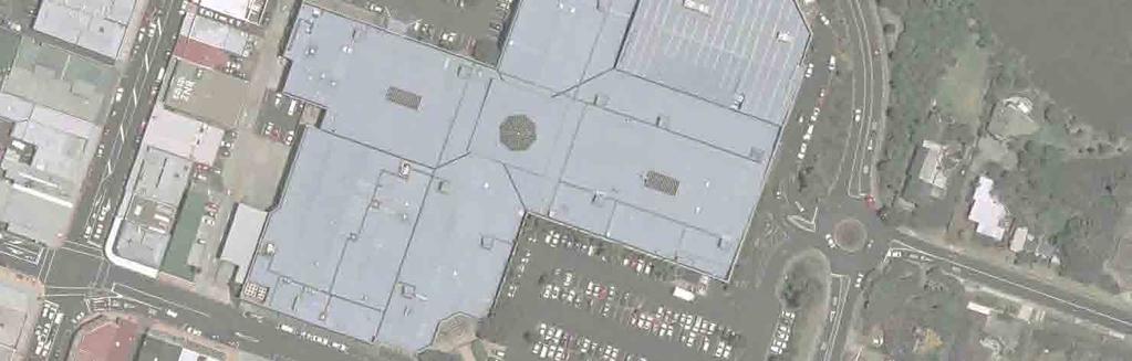
7 2. Introduction 2.1 General Sinclair Knight Merz (SKM) has been commissioned by Milford Centre Ltd ( MCL ) to prepare a geotechnical assessment for a proposed plan change application for the Milford Shopping Centre ( MSC ) site. Site location and layout plans are presented on drawings 001 and 002 in Appendix A. 2.2 Background The proposed plan change seeks to achieve an amendment of relevant existing provisions within the operative North Shore City Council district plan as well as the insertion of new provisions into the district plan. The proposed amendments to the district plan will provide for high density residential development. It is noted that the provisions will themselves provide for resource consent approval for the development to be sought at a later date. Building consent approval will of course also be required. These processes subsequent to the plan change will provide an opportunity for Council to adequately control, by way of design assessment and through consent conditions, any specific requirements that arise from the recommendations of this report. The basis for analysis within this report is approximately 250 residential units, to be provided for within the existing site by way of several new buildings which could be built to the following Reduced Levels (RL): - Building 1 63 metres - Building metres - Building metres 2.3 Scope The scope of this geotechnical assessment is to: - identify geotechnical conditions, - discuss hydrogeological issues, - provide commentary on geotechnical issues, and - provide geotechnical recommendations for the development to be provided for via the plan change. Geotech final PAGE 2
8 3. Site Setting 3.1 Site Description The MSC site is located at 143 Kitchener Road, Milford and is located within a block defined by Milford Road to the east, Ihumata Road to the north, Omana Road to the west and the shops fronting Kitchener Road to the south. The site is utilised by the existing MSC. The shopping centre comprises a mixed occupancy, primarily a retail mall. Well known retailers operating from the MSC include The Warehouse, Woolworths and Whitcoulls. Associated asphalt carparking as well as landscaping are also located on site. Prior to development of the MSC in , the Milford Mariana Hotel, shops and a motel with associated private residences were located on the site. At its widest point (Milford Road to Omana Road) the site is approximately 205m across. Topographically, the site generally falls in a northwest direction towards the Wairau creek, with levels ranging from approximately RL 13m nearest the Milford Road / Kitchener Road intersection, to approximately RL 2.5m in the lower area of the site fronting Omana Road / the Wairau Creek. 3.2 High Density Residential Proposal The basis for analysis within this report is approximately 250 residential units, to be developed on the site by way of several new buildings which range from RL 34 metres to RL 63 metres. The main buildings will be located: - Building 1 fronting Omana Road to the northwest of the site - Building 2 fronting Omana Road, near the existing roundabout, to the north of the site - Building 3 set back from Milford Road, to the north east of the site The areas of development are shown on drawing 002 in Appendix A. 3.3 Geology Information regarding the site geology has been obtained principally from the Geology of the Auckland Urban Area Map (Sheet 2, 1:50:000), as well as from previous investigations carried out in 1993, 2006 and The geology beneath the site is not uniformly consistent. Generally, the site is indicated to be underlain by alluvial/colluvial deposits which are in turn, in certain places, underlain by solid strata belonging to the East Coast Bays Formation comprising residually weathered, alternating sandstone and mudstone with variable volcanic content and interbedded volcaniclastic grit beds. Geotech final PAGE 3
9 Incising the alluvium toward the east of the site is basalt lava belonging to the Kerikeri Volcanic Group. Previous intrusive investigations have identified heterogeneous fill deposits directly beneath hardstanding across the site. These deposits have been generally described as firm to stiff, orange/brown/grey, dry to moist clay or silt containing organic matter, gravel (basaltic/scoriaeous) and occasional glass, wood and shell fragments. Fill has also been described as loose to stiff, slightly plastic, dark brown/grey moist silty gravel/silt. This was identified at the centre and south of the site. We have not reviewed any information regarding the potential for contamination within the fill. Volcanic ash and lapilli generally described as stiff, moist, moderately plastic, reddish brown, sandy silt with minor clay and gravel was recorded to the northeast of the site beneath the current carpark area. A cross-section (taken NW-SE through the site) identifying the geology beneath the site and a borehole location plan are presented on drawings 003 and 004 respectively in Appendix A. 3.4 Hydrogeology Local water resources which affect groundwater flow are: - the Wairau estuary adjacent to the site to the north west - Lake Pupuke located approx 400m from the site to the south - Milford Beach / Hauraki Gulf Coastline located approx 600 m from the site, to the north east Based on the available information, which includes levels pre and post development (in reference to the existing MSC); groundwater exists at relatively shallow depths beneath the site. Groundwater levels, recorded in boreholes toward the east of the site, show that depths to groundwater have varied, since 1993, between 1.5 and 5.9 m). There is limited information regarding groundwater for this site. However, recent monitoring was initiated by SKM, including; re-drilling of borehole P8 (now renamed BH08) and installing two standpipe piezometers at deep and shallow depths. Recent monitoring visits (July to August 2007) have identified groundwater at depths of between 1.4m and 1.78m. Monitoring will continue until December It is anticipated that groundwater flow will be in a northwest/northerly direction toward the Wairau Estuary. Geotech final PAGE 4
10 4. Geotechnical Appraisal 4.1 Previous Investigations To date, three geotechnical investigation assessment reports/letters have been produced regarding the site. This section of the report briefly reviews the key findings from the following investigations: Foundation Investigation for Proposed Milford Shopping Centre dated September 1993, Soil & Rock Consultants (Ref: 93123); Subsoil Investigation for Carpark Areas at Milford Shopping Centre, Milford, North Shore City, dated May 2006, Soil & Rock Consultants (Ref: 06114); and Rotary Percussion Drilling Carpark area at Milford Shopping Centre, Milford dated January 2007, Soil & Rock Consultants (Ref: 06114). A summary borehole location plan is presented on drawing 004 in Appendix A. 4.2 September 1993 Foundation Investigation The 1993 Soil & Rock Consultants report was produced prior to construction of the existing MSC. The intrusive investigation comprised 11 boreholes (to a maximum depth of 19.5m), 6 hand auger holes (to a maximum depth of 3.3m) and 6 Scala Penetrometer tests. The subsoil conditions were recorded with respect to the two terraces or ground levels which formed the topography of the site in Generally ground conditions across the site comprised asphalt underlain by varying units of clay and silt overlying basalt. Basalt was recorded at depths of between 1 and 5.2m with a maximum thickness of 3.5m. Recommendations were provided for development of the MSC. 4.3 May 2006 Subsoil Investigation for Carpark Areas The 2006 Soil & Rock Consultants report was produced after development of the MSC. The investigation was carried out to assess subsurface ground conditions related to expanding the existing car parking space. Following intrusive investigation comprising 21 hand augerholes (AH1 to AH21) and Scala penetrometer testing, subsoil conditions were found to be consistent with those identified in the previous site investigation report. The report states the site comprised volcanic deposits overlain by hardfill and earthfill. Geotech final PAGE 5
11 The main findings included a basalt mound beneath the old Marina hotel building and across the MSC carpark. 4.4 January 2007 Rotary Percussion Drilling Rotary drilling was carried out in January 2007 to further quantify the depth and thickness of basalt rock beneath the shopping centre carpark. The supplementary investigation comprised 13 boreholes. The depth to basalt was proved between 2.2 and 4.3m. The maximum thickness of basalt was recorded as approximately 6.8m, located at the north-western corner of the carpark. It should be noted that thicknesses determined by this intrusive investigation are based solely on the base of the borehole. The actual thickness of the basalt is likely to exceed this. Generally the basalt was fractured at the top of the unit. The material lying straigraphically above the basalt was described as Volcanic Ash, generally described as reddish brown, sandy SILT, minor gravel, very stiff, moist, and moderately plastic. Groundwater was recorded in one location at the centre of the carpark, within the fractured basalt at depths of 5.5 and 5.9m. Geotech final PAGE 6
12 4.5 Geotechnical Considerations Foundation Design Based on current geotechnical information, the underlying ground conditions are considered suitable for the proposed development. This position is based on the results of earlier reporting and our site investigations. Foundations for the main buildings are likely to be piled, however there is the potential for pad or raft foundations in the areas underlain by basalt. Further investigation is required to develop foundation design parameters. Excavations and Groundwater Excavations at the site should be feasible using an appropriate type of hydraulic plant. However, any significant excavations into the basalt may require controlled blasting to minimise the duration of adverse effects from noise and vibration. All excavations at the site will require adequate lateral support, or battering back to a safe angle, to ensure their stability. The potential for contamination of the fill identified at the centre and south of the site will need to be assessed at resource consent stage, so that appropriate plans can be developed for safe management and disposal of the material. Groundwater is likely to be encountered in excavations and will need to be adequately controlled during construction. Geotech final PAGE 7
13 5. Recommendations In our opinion, there are no geotechnical nor hydrogeological reasons for refusing the proposed plan change. We recommend that further site investigations be carried out at the resource consent phase to provide design parameters for foundations and retaining walls, and the safe management of excavations and groundwater during construction. The further detailed geotechnical investigation should include shallow and deep boreholes. This should also include the installation of groundwater monitoring wells and geotechnical laboratory testing. These assessments will provide the basis for Council to institute the necessary conditions through the further consent processes to ensure adequate foundations, retaining structures and groundwater controls are in place. Geotech final PAGE 8
14 6. References The Geology of the Auckland Area (1:250,000 Map extract 3), Institute of Geological and Nuclear Sciences, Foundation Investigation for Proposed Milford Shopping Centre dated September 1993, Soil & Rock Consultants (Ref: 93123). Subsoil Investigation for Carpark Areas at Milford Shopping Centre, Milford, North Shore City, dated May 2006, Soil & Rock Consultants (Ref: 06114). Rotary Percussion Drilling Carpark area at Milford Shopping Centre, Milford dated January 2007, Soil & Rock Consultants (Ref: 06114). Geotech final PAGE 9
15 Appendix A - Figures Geotech final PAGE 10


16


17
18


19
Lake Rotoiti Wastewater Scheme - Stage 1 Investigations. Rotorua Lakes Council
 Lake Rotoiti Wastewater Scheme - Stage 1 Investigations Rotorua Lakes Council i Contents 1 Introduction...1 2 Site Description...1 3 Geological Setting...1 4 Geotechnical Investigation...1 4.1 Borehole
Appendix A. Producer Statement Advisory Note
 Appendix A Producer Statement Advisory Note Ref. No. 17095 26 May 2017 PRODUCER STATEMENT CONSTRUCTION REVIEW (PS4) IMPORTANT ADVISORY NOTE The Building Consent Authority (BCA) frequently requires Producer
16 January 2018 Job Number: RICHARD NEWMAN C\- CLARK FORTUNE MCDONALD AND ASSOCIATES PO BOX 553 QUEENSTOWN
 16 January 2018 Job Number: 50595 RICHARD NEWMAN C\- CLARK FORTUNE MCDONALD AND ASSOCIATES PO BOX 553 QUEENSTOWN CHANSEN@CFMA.CO.NZ STORMWATER DISPOSAL ASSESSMENT Dear Richard, RDAgritech were requested
REPORT. Housing Re-Zone. Middle Road and Iona Road - Geotechnical Investigation Report
 REPORT Housing Re-Zone Middle Road and Iona Road - Geotechnical Investigation Report Prepared for Hastings istrict Council Prepared by Tonkin & Taylor Ltd ate April 06 Job Number 464.000 istribution: Hastings
patersongroup Mineral Aggregate Assessment 3119 Carp Road Ottawa, Ontario Prepared For Mr. Greg LeBlanc March 7, 2014 Report: PH2223-REP.
 Geotechnical Engineering Environmental Engineering group Hydrogeology Geological Engineering Archaeological Studies Materials Testing 3119 Carp Road Prepared For Mr. Greg LeBlanc March 7, 2014 Paterson
Earthquake Commission Darfield Earthquake Recovery Geotechnical Factual Report New Brighton
 REPORT Earthquake Commission Darfield Earthquake Recovery Geotechnical Factual Report New Brighton REPORT Earthquake Commission Darfield Earthquake Recovery Geotechnical Factual Report New Brighton Report
AGENDA ITEM 6 APPENDIX /0151/DET GROUND WATER & SURFACE WATER MANAGEMENT PLAN
 CAIRNGORMS NATIONAL PARK AUTHORITY Planning Committee Agenda Item 6 Appendix 18 12/10/2018 AGENDA ITEM 6 APPENDIX 18 2018/0151/DET GROUND WATER & SURFACE WATER MANAGEMENT PLAN Dalwhinnie Quarry Ground
APPENDIX H SOIL SURVEY
 Environmental Impact Statement Beryl Solar Farm APPENDIX H SOIL SURVEY Beryl Solar Farm 16 347 Final V1 H i Geotechnical Engineers & Engineering Geologists NATA Accredited Laboratories for Asphalt, Aggregate,
14 Geotechnical Hazards
 Volume 2: Assessment of Environmental Effects 296 14 Geotechnical Hazards Overview This Chapter provides an assessment of the underlying geotechnical conditions to identify: any potential liquefaction
New Plymouth CBD Site Subsoil Class: Results from ground investigation
 Alexander, G.J., Chin, C.Y., Kayser, C. & Bradshaw, J. (2017) New Plymouth CBD Site Subsoil Proc. 20 th NZGS Geotechnical Symposium. Eds. GJ Alexander & CY Chin, Napier New Plymouth CBD Site Subsoil Class:
Hydrogeological Assessment for Part of Lots 2 and 3, Concession 5, Township of Thurlow, County of Hastings 1.0 INTRODUCTION. 1.
 February 10,2017 25506400 Ontario Ltd. Foxboro, ON Attention: Brad Newbatt Re: Hydrogeological Assessment for Part of Lots 2 and 3, Concession 5, Township of Thurlow, County of Hastings 1.0 INTRODUCTION
DATA REPORT GEOTECHNICAL INVESTIGATION GALVESTON CRUISE TERMINAL 2 GALVESTON, TEXAS
 DATA REPORT GEOTECHNICAL INVESTIGATION GALVESTON CRUISE TERMINAL 2 GALVESTON, TEXAS SUBMITTED TO PORT OF GALVESTON 123 ROSENBERG AVENUE, 8TH FLOOR GALVESTON, TEXAS 77553 BY HVJ ASSOCIATES, INC. HOUSTON,
STATEMENT OF EVIDENCE OF SHANE LANDER (GEOTECHNICAL - QD2) ON BEHALF OF MURPHYS DEVELOPMENTS LIMITED
 ON BEHALF OF MURPHYS DEVELOPMENTS LIMITED") IN THE MATTER of the Housing Accords and Special Housing Areas Act 2013 ("HASHAA") AND IN THE MATTER of Proposed Qualifying Development Application ("QD2") for 125 Murphys Road, Flat Bush BETWEEN Murphys
IN THE MATTER of the Housing Accords and Special Housing Areas Act 2013 ("HASHAA") AND IN THE MATTER of Proposed Qualifying Development Application ("QD2") for 125 Murphys Road, Flat Bush BETWEEN Murphys
Re: Steep Slope Assessment for 2465 Waverly Drive, Blind Bay, BC; Legal Address: Lot 39, Section 18, Township 22, Range 10, Plan 25579, W6M, KDYD.
 OEL File 1563-1 May 30, 2017 Doug Wall PO Box 774 Salmon Arm, BC V1E 4N7 Re: Steep Slope Assessment for 2465 Waverly Drive, Blind Bay, BC; Legal Address: Lot 39, Section 18, Township 22, Range 10, Plan
Omaroro Lower Playing Field - Geotechnical Interpretive Report
 Report Omaroro Lower Playing Field - Geotechnical Interpretive Report Prepared for Wellington Water Limited Prepared by Beca Limited 1 December 2017 Omaroro Lower Playing Field - Geotechnical Interpretive
ARCHAEOLOGICAL S E R V I C E S. 1 Beechmount Road, Southampton, Hampshire. Archaeological Watching Brief. by David Platt. Site Code: SOU1649
 T H A M E S V A L L E Y ARCHAEOLOGICAL S E R V I C E S 1 Beechmount Road, Southampton, Hampshire Archaeological Watching Brief by David Platt Site Code: SOU1649 (SU 4188 1616) 1 Beechmount Road, Southampton,
REPORT NO 12/115/D NOVEMBER 2012 GEOTECHNICAL INVESTIGATION FOR THE PROPOSED SOLAR PHOTOVOLTAIC FACILITY, GROOTVLEI POWER STATION
 Consulting Geotechnical Engineers & Engineering Geologists P.O.Box 3557 Cramerview 2060. Tel: (011) 465-1699. Fax: (011) 465-4586. Cell 082 556 7302 & 076 966 8445 REPORT NO 12/115/D NOVEMBER 2012 GEOTECHNICAL
LEGEND BUSINESS ZONE NORTH OF AGRESEARCH BOREHOLE CPT SEISMIC CPT AUGER SCALE. Powells Road TEST PIT AGRESEARCH INNOVATION PARK. Hamilton Ring Road
 LEGEND ra R aku Ru BUSINESS ZONE NORTH OF Powells Road oad AGRESEARCH BOREHOLE CPT SEISMIC CPT AUGER SCALE 3 mm TEST PIT AS121 SCPT12 TP18 BH13 TP15 2 AS125 AS126 TP14 BH12 AGRESEARCH CPT13 TP17 INNOVATION
GEOTECHNICAL INVESTIGATION REPORT PROPOSED MIXED USE DEVELOPMENT 54 PARKWAY DRIVE ROSEDALE, AUCKLAND
 K170412-1 9 August 2017 GEOTECHNICAL INVESTIGATION REPORT PROPOSED MIXED USE DEVELOPMENT 54 PARKWAY DRIVE ROSEDALE, AUCKLAND Prepared For: Lucy Li c/- DCS Ltd Unit 67 Victoria Park Market PO Box 91247,
General. DATE December 10, 2013 PROJECT No TO Mary Jarvis Urbandale/Riverside South Development Corporation
 DATE December 10, 201 PROJECT No. 10-1121-0260- TO Mary Jarvis Urbandale/Riverside South Development Corporation CC Justin Robitaille, Urbandale Jonathan Párraga, J.L. Richards & Associates Limited FROM
KANSAS GEOLOGICAL SURVEY Open File Report LAND SUBSIDENCE KIOWA COUNTY, KANSAS. May 2, 2007
 KANSAS GEOLOGICAL SURVEY Open File Report 2007-22 LAND SUBSIDENCE KIOWA COUNTY, KANSAS Prepared by Michael T. Dealy L.G., Manager, Wichita Operations SITE LOCATION The site was approximately four miles
3.4 Typical Soil Profiles
 SEI.UoC.0002.11 Figure 4. Streams in central Christchurch as mapped in March 1850, superposed on aerial photography captured on 24 February 2011. Streams digitised from the Black Map of Christchurch (March
3.0 GEOLOGY AND HYDROGEOLOGY
 3.0 GEOLOGY AND HYDROGEOLOGY 3.1 Methodology The Geological Survey of Ireland (GSI) publication Geology of South Cork was consulted to establish the nature of the bedrock lithology and Quaternary sediments.
BP Connect Development Turangi Preliminary Geotechnical Assessment Report
 The Holmes Group BP Connect Development Turangi Preliminary Geotechnical Assessment Report The Holmes Group BP Connect Development Turangi Preliminary Geotechnical Assessment Report Prepared By Opus International
GEOTECHNICAL ENGINEERING II. Subject Code : 06CV64 Internal Assessment Marks : 25 PART A UNIT 1
 GEOTECHNICAL ENGINEERING II Subject Code : 06CV64 Internal Assessment Marks : 25 PART A UNIT 1 1. SUBSURFACE EXPLORATION 1.1 Importance, Exploration Program 1.2 Methods of exploration, Boring, Sounding
Geotechnical Completion Report Knights Stream Park Stage3A Development (Lots 107 to 148)
") Aurecon New Zealand Limited Unit 1, 150 Cavendish Road Casebrook Christchurch 8051 PO Box 1061 Christchurch 8140 New Zealand T F E W +64 3 366 0821 +64 3 379 6955 christchurch@aurecongroup.com aurecongroup.com
Aurecon New Zealand Limited Unit 1, 150 Cavendish Road Casebrook Christchurch 8051 PO Box 1061 Christchurch 8140 New Zealand T F E W +64 3 366 0821 +64 3 379 6955 christchurch@aurecongroup.com aurecongroup.com
ENCE 3610 Soil Mechanics. Site Exploration and Characterisation Field Exploration Methods
 ENCE 3610 Soil Mechanics Site Exploration and Characterisation Field Exploration Methods Geotechnical Involvement in Project Phases Planning Design Alternatives Preparation of Detailed Plans Final Design
 5.2 APPENDIX D2 Geotechnical Report Jeffares & Green: 03524: Ilinge and Lesseyton Cemetery Development ILINGE AND LESSEYTON CEMETERY DEVELOPMENT - GEOTECHNICAL INVESTIGATION FINAL REPORT SEPTEMBER 2014
June 9, R. D. Cook, P.Eng. Soils Engineer Special Services Western Region PUBLIC WORKS CANADA WESTERN REGION REPORT ON
 PUBLIC WORKS CANADA WESTERN REGION REPORT ON GEOTECHNICAL INVESTIGATION PROPOSED MARTIN RIVER BRIDGE MILE 306.7 MACKENZIE HIGHWAY Submitted by : R. D. Cook, P.Eng. Soils Engineer Special Services Western
Gotechnical Investigations and Sampling
 Gotechnical Investigations and Sampling Amit Prashant Indian Institute of Technology Gandhinagar Short Course on Geotechnical Investigations for Structural Engineering 12 14 October, 2017 1 Purpose of
University of Fort Hare, Alice Campus
 University of Fort Hare, Alice Campus Geotechnical Investigation COMPILED FOR: MBB Consulting Engineers P O Box 509 Grahamstown 6140 Telephone: +27 (0)46 622 7223 Facsimile: +27 (0)86 570 7844 COMPILED
Oxford Bus Company Depot, Cowley Road, Oxford
 Oxford Bus Company Depot, Cowley Road, Oxford An Archaeological Evaluation (Stage 2) for Berkeley Homes (Oxford and Chiltern) Ltd by Jo Pine Thames Valley Archaeological Services Ltd Site Code GAG 00/32
Central Queensland Coal Project Appendix 4b Geotechnical Assessment. Environmental Impact Statement
 Central Queensland Coal Project Appendix 4b Geotechnical Assessment Environmental Impact Statement GEOTECHNICAL ASSESSMENT OF OPEN CUT MINING ADJACENT TO THE BRUCE HIGHWAY, CENTRAL QUEENSLAND COAL PROJECT
Prediction of subsoil subsidence caused by opencast mining
 Land Subsidence (Proceedings of the Fifth International Symposium on Land Subsidence, The Hague, October 1995). IAHS Publ. no. 234, 1995. 167 Prediction of subsoil subsidence caused by opencast mining
Oxford Options Resource Centre, Horspath Driftway, Headington, Oxford
 Oxford Options Resource Centre, Horspath Driftway, Headington, Oxford An Archaeological Watching Brief For Oxfordshire County Council by Tim Dawson and Heather Hopkins Thames Valley Archaeological Services
Slope Stability Assessment Proposed Development 4401 Fallowfield Road Lands Ottawa, Ontario Rev-02
 REPORT August 2014 REPORT ON Slope Stability Assessment Proposed Development 4401 Fallowfield Road Lands Ottawa, Ontario Submitted to: DCR Phoenix Homes 18 Bentley Avenue Ottawa, Ontario K2E 6T8 Report
Diddenham Court, Grazeley, Reading, Berkshire, Phase 2
 Diddenham Court, Grazeley, Reading, Berkshire, Phase 2 An Archaeological Watching Brief For Fenchurch Estates (Diddenham) Ltd by Steve Hammond and Simon Cass Thames Valley Archaeological Services Ltd Site
Engineer. Engineering. Engineering. (in-ja-neer ) A person trained and skilled in any of the various branches of engineering: a civil engineer
 A person trained and skilled in any of the various branches of engineering: a civil engineer") Engineer (in-ja-neer ) A person trained and skilled in any of the various branches of engineering: a civil engineer (Random House Webster s College Dictionary, 1991) CE100 Introduction to Civil Geotechnical
Engineer (in-ja-neer ) A person trained and skilled in any of the various branches of engineering: a civil engineer (Random House Webster s College Dictionary, 1991) CE100 Introduction to Civil Geotechnical
Free Range Broiler Farm, Arapohue: Geotechnical assessment
 Free Range Broiler Farm, Arapohue: Geotechnical assessment Prepared for Date September 2017 Job Number 1003028 Document Control Title: Date Version Description Prepared by: Reviewed by: Authorised by:
Report to Tyris Realty on a Geotechnical Investigation for a Proposed Warehouse Development at Sprite Place, Westmead
 Report to Tyris Realty on a Geotechnical Investigation for a Proposed Warehouse Development at Sprite Place, Westmead Reference : 11-358 Dated : February 2012 MOORE SPENCE JONES (PTY) LTD Consulting Geotechnical,
Preliminary Geotechnical Evaluation Gooseberry Point Pedestrian Improvements Whatcom County, Washington SITE AND PROJECT DESCRIPTION
 File No. 12-100 Geotechnical & Earthquake Engineering Consultants Mr. Kevin Brown, P.E. Gray & Osborne, Inc. 3710 168 th Street NE, Suite B210 Arlington, Washington 98223 Subject: Draft Report Preliminary
Superficial Geology Map - Slice A. Order Details: Order Number: Customer Reference: National Grid Reference: Slice: Site Area (Ha): Search Buffer (m):
: Search Buffer (m):") Superficial Geology Superficial Deposits are the youngest geological deposits formed during the most recent period of geological time, the Quaternary, which extends back about 1.8 million years from the
Superficial Geology Superficial Deposits are the youngest geological deposits formed during the most recent period of geological time, the Quaternary, which extends back about 1.8 million years from the
Acrefield Cottage, Winkfield Street, Maidens Green, Winkfield, Windsor, Berkshire
 Acrefield Cottage, Winkfield Street, Maidens Green, Winkfield, Windsor, Berkshire An Archaeological Watching Brief For Mr and Mrs Elia by Pamela Jenkins Thames Valley Archaeological Services Ltd Site Code
Slope Stability Evaluation Ground Anchor Construction Area White Point Landslide San Pedro District Los Angeles, California.
 Slope Stability Evaluation Ground Anchor Construction Area White Point Landslide San Pedro District Los Angeles, California Submitted To: Mr. Gene Edwards City of Los Angeles Department of Public Works
Christchurch CBD: Lessons Learnt and Strategies for Foundation Remediation 22 February 2011 Christchurch, New Zealand, Earthquake
 Christchurch CBD: Lessons Learnt and Strategies for Foundation Remediation 22 February 2011 Christchurch, New Zealand, Earthquake K.M. Murahidy & A.F. Sleight Tonkin & Taylor Ltd, Christchurch, New Zealand
Site 3: Park Road, Katikati: field logs, stratigraphic description, and site description
 Appendix 4.2 Site 3: Park Road, Katikati: field logs, stratigraphic description, and site description Criteria suitability The third site selected was at Park Road Reserve, Katikati (Figure 1). This site
2. Initial Summary of Preliminary Expert Opinion of Converse and Psomas Reports
 UNITED WALNUT TAXPAYERS PRELIMINARY REVIEW OF NEGATIVE GEOTECHNICAL AND GEOLOGICAL ASPECTS OF CONSTRUCTING EARTHFILL PAD FOR A SOLAR FARM ON THE WEST PARCEL - DRAFT 1. Introduction A licensed Engineering
GEOTECHNICAL INVESTIGATION REPORT INFRASTRUCTURE PVT LTD
 GEOTECHNICAL INVESTIGATION REPORT Client : TAEIN CONSTRUCTION & INFRASTRUCTURE PVT LTD Office address : Flat No.104, A -Wing,1st floor,gloria Park, Paranjape Scheme, Bavdhan Khurd, Chandni Chowk, Pune
REPORT ON SLOPE STABILITY INVESTIGATION DON MILLS ROAD AND EGLINTON AVENUE EAST TORONTO, ONTARIO. Prepared for:
 REPORT ON SLOPE STABILITY INVESTIGATION DON MILLS ROAD AND EGLINTON AVENUE EAST TORONTO, ONTARIO Prepared for: TORONTO AND REGION CONSERVATION AUTHORITY Prepared By: SIRATI & PARTNERS CONSULTANTS LIMITED
Appendix F Geotechnical Investigation
 Appendix F Geotechnical Investigation Cie Sucriere de Bel Ombre Ltee Residential Development at Bel Ombre Environmental Impact Assessment F1 Geotechnical Investigation This appendix includes the Factual
Northern Colorado Geotech
 PRELIMINARY GEOTECHNICAL ENGINEERING REPORT PROPOSED CECIL FARMS DEVELOPMENT WELD COUNTY ROAD 7, BETWEEN ROADS 7 AND 7 SEVERANCE, COLORADO NORTHERN COLORADO GEOTECH PROJECT NO. 0-6 APRIL 0, 06 Prepared
Proposed Cemetery Thornhill Road. Tier One Hydrogeological Risk Assessment. Peter Mitchell Associates
 Proposed Cemetery Thornhill Road Tier One Hydrogeological Risk Assessment Peter Mitchell Associates January 2015 Executive Summary This report uses a desk-based risk assessment technique published by the
Manor Farm, Otley Road, Adel - preliminary findings
 005/87/ 6 th September 07 Mr G Titchmarsh Titchmarsh & Bagley. Prospect House Sovereign Street Leeds LS BJ Registered in England 07068066 Parkhill Wetherby West Yorkshire LS 5DZ T 097 55 0 www.lithos.co.uk
DRENNAN MAUD (PTY) LTD
 LTD") DRENNAN MAUD (PTY) LTD GEOTECHNICAL ENGINEERS AND ENGINEERING GEOLOGISTS Incorporating Drennan Maud & Partners (Est.1975) and GAP Consulting Reg. No. 2014/038872/07 Durban Head Office Info@drennanmaud.com
DRENNAN MAUD (PTY) LTD GEOTECHNICAL ENGINEERS AND ENGINEERING GEOLOGISTS Incorporating Drennan Maud & Partners (Est.1975) and GAP Consulting Reg. No. 2014/038872/07 Durban Head Office Info@drennanmaud.com
HISTORY OF CONSTRUCTION FOR EXISTING CCR SURFACE IMPOUNDMENT PLANT GASTON ASH POND 40 CFR (c)(1)(i) (xii)
(1)(i) (xii)") HISTORY OF CONSTRUCTION FOR EXISTING CCR SURFACE IMPOUNDMENT PLANT GASTON ASH POND 40 CFR 257.73(c)(1)(i) (xii) (i) Site Name and Ownership Information: Site Name: E.C. Gaston Steam Plant Site Location:
HISTORY OF CONSTRUCTION FOR EXISTING CCR SURFACE IMPOUNDMENT PLANT GASTON ASH POND 40 CFR 257.73(c)(1)(i) (xii) (i) Site Name and Ownership Information: Site Name: E.C. Gaston Steam Plant Site Location:
patersongroup Consulting Engineers April 20, 2010 File: PG1887-LET.01R Novatech Engineering Consultants Suite 200, 240 Michael Cowpland Drive
 patersongroup April 20, 2010 File: PG1887-LET.01R Novatech Engineering Consultants Suite 200, 240 Michael Cowpland Drive Ottawa, Ontario K2M 1P6 Attention: Mr. Adam Thompson Consulting Engineers 28 Concourse
The Soils and Land Capability for Agriculture. Land North of Aberdeen, Aberdeenshire
 The Soils and Land Capability for Agriculture Of Land North of Aberdeen, Aberdeenshire Report prepared for Peter Radmall Associates May 2012 Reading Agricultural Consultants Ltd Beechwood Court, Long Toll,
10. GEOTECHNICAL EXPLORATION PROGRAM
 Geotechnical site investigations should be conducted in multiple phases to obtain data for use during the planning and design of the tunnel system. Geotechnical investigations typically are performed in
BELFAST SEWERS PROJECT
 BELFAST SEWERS PROJECT Adam Green - Atkins Tunnelling Scheme Overview New stormwater interceptor Tunnel Scheme within Belfast City Centre to alleviate flooding and divert storm water flows from existing
SITE INVESTIGATION 1
 SITE INVESTIGATION 1 Definition The process of determining the layers of natural soil deposits that will underlie a proposed structure and their physical properties is generally referred to as site investigation.
REPORT. Earthquake Commission. Christchurch Earthquake Recovery Geotechnical Factual Report Bryndwr Appendix C: Borehole Logs
 REPORT Earthquake Commission Christchurch Earthquake Recovery Geotechnical Factual Report Bryndwr Appendix C: Borehole Logs REPORT Earthquake Commission Christchurch Earthquake Recovery Geotechnical Factual
Roman Farm, Nettleden, Hemel Hempstead, Hertfordshire
 Roman Farm, Nettleden, Hemel Hempstead, Hertfordshire An Archaeological Watching Brief for Mercantile Land Development Ltd by Siân Anthony Thames Valley Archaeological Services Ltd Site Code RFN01/82 October
CENTRAL REGION GEOHAZARDS RISK ASSESSMENT SITE INSPECTION FORM
 SITE NUMBER AND NAME C55 H861:02 Slide LEGAL DESCRIPTION NW 14-40-14-W4 CENTRAL REGION GEOHAZARDS RISK ASSESSMENT SITE INSPECTION FORM HIGHWAY & KM NAD 83 COORDINATES N 5811217 E 437291 PREVIOUS INSPECTION
Report on Site Classification & Construction Testing
 Report on Site Classification & Construction Testing Northlakes Estate Stage 29, Cameron Park CGS1871 CGS1871 Prepared for Northlakes Pty Ltd C/- McCloy Group Pty Ltd December 2013 Report on Site Classification
Appendix 6 Geotechnical report
 Page 56 Appendix 6 Geotechnical report 1. Introduction The following provides an initial and preliminary description/assessment of the overall geology, the likely ground conditions and preliminary geotechnical
Performance and Post Earthquake Assessment of CFA Pile Ground Improvement 22 February 2011 Christchurch, New Zealand Earthquake
 Performance and Post Earthquake Assessment of CFA Pile Ground Improvement 22 February 2011 Christchurch, New Zealand Earthquake K. M. Murahidy, S. W Sutherland & M. E. Jacka Tonkin & Taylor Ltd, Christchurch,
Thames Valley University, Kings Road, Reading, Berkshire
 Thames Valley University, Kings Road, Reading, Berkshire An Archaeological Evaluation for Thames Valley University by Danielle Milbank and Steve Ford Thames Valley Archaeological Services Ltd Site Code
Distribution: Tonkin & Taylor Ltd (FILE) 1 copy 1 copy
 1 copy 1 copy") REPORT Proposed Second Runway Geotechnical Environmental Baseline Report Prepared for Prepared by Tonkin & Taylor Ltd Date October 2015 Job Number 29777.2000.v3 Distribution: Tonkin & Taylor Ltd (FILE)
REPORT Proposed Second Runway Geotechnical Environmental Baseline Report Prepared for Prepared by Tonkin & Taylor Ltd Date October 2015 Job Number 29777.2000.v3 Distribution: Tonkin & Taylor Ltd (FILE)
SLOPE STABILITY ASSESSMENT PROPOSED RESIDENTIAL SUBDIVISION 161 LAKESHORE ROAD EAST TOWN OF THE BLUE MOUNTAINS, ONTARIO
 SLOPE STABILITY ASSESSMENT PROPOSED RESIDENTIAL SUBDIVISION 161 LAKESHORE ROAD EAST TOWN OF THE BLUE MOUNTAINS, ONTARIO PETO MacCALLUM LTD. 19 CHURCHILL DRIVE BARRIE, ONTARIO L4N 8Z5 PHONE: (705) 734-3900
Report prepared for: Report prepared by: Auckland Council. Geotechnical Desk Study South Auckland Rural Urban Boundary Project.
 REPORT Auckland Council Geotechnical Desk Study South Auckland Rural Urban Boundary Project Report prepared for: Auckland Council Report prepared by: Tonkin & Taylor Ltd Distribution: Auckland Council
KRIS wsbssm. IBHiiilll
 KRIS wsbssm IBHiiilll Digitized by the Internet Archive in 2012 with funding from University of Illinois Urbana-Champaign http://archive.org/details/engineeringaspec34ekbl STATE OF ILLINOIS HENRY HORNER,
Appendix Z. Groundwater Assessment Supplementary Report. Document Name i Insert Month/Year
 Appendix Z Groundwater Assessment Supplementary Report Document Name i Insert Month/Year Australasian Groundwater and Environmental Consultants Pty Ltd Level 2 / 15 Mallon Street Bowen Hills, QLD 4006
IV. ENVIRONMENTAL IMPACT ANALYSIS G. GEOLOGY AND SOILS
 IV. ENVIRONMENTAL IMPACT ANALYSIS G. GEOLOGY AND SOILS The following section is based upon the City of El Segundo General Plan and General Plan EIR and addresses the following geologic issues: soil erosion,
Geotechnical Data Report
 Geotechnical Data Report Downtown Greenville Future Conveyance Study December 1, 2015 Terracon Project No. 86155032 Prepared for: Prepared by: Terracon Consultants, Inc. December 1, 2015 561 Mauldin Road
GEOTECHNICAL INVESTIGATION. Proposed Douglas Street Bus Lane
 May, 0 GEOTECHNICAL INVESTIGATION Proposed Douglas Street Bus Lane Submitted to: Greg Smith P.Eng. Senior Transportation Engineer Urban Systems Ltd. 0- Homer Street Vancouver, BC V6B W9 REPORT Report Number:
Ardaman & Associates, Inc. Geotechnical, Environmental and Materials Consultants
 SUBSURFACE SOIL EXPLORATION ANALYSIS AND RECOMMENDATIONS LELY AREA STORMWATER IMPROVEMENT PROJECT (LASIP) COUNTY BARN ROAD AND WING SOUTH CHANNELS NAPLES, COLLIER CO., FLORIDA Ardaman & Associates, Inc.
Guidelines for Geotechnical Site Investigation for Residential Building Consents in Hastings District. (Draft)
") Guidelines for Geotechnical Site Investigation for Residential Building Consents in Hastings District (Draft) December 2017 Acknowledgements These guidelines have been prepared with assistance from Tonkin
Guidelines for Geotechnical Site Investigation for Residential Building Consents in Hastings District (Draft) December 2017 Acknowledgements These guidelines have been prepared with assistance from Tonkin
GEOTECHNICAL INVESTIGATION FOSTER BLOCK, GOULDS ROAD ROLLESTON
 GEOTECHNICAL INVESTIGATION FOSTER BLOCK, GOULS ROA ROLLESTON SUBMITTE TO: R.. HUGHES EVELOPMENTS LT PO BOX 848 CHRISTCHURCH 8140 21 ecember 2011 ISTRIBUTION 2 Copies R.. Hughes evelopments Ltd 1 Copy Geoscience
Tunnelling through volcaniclastic grit; monitoring and management of groundwater effects on the Waterview Connection Project
 France, S. (2017) Tunnelling through volcaniclastic grit; monitoring and management of groundwater effects on the Waterview Connection Project Proc. 20 th NZGS Geotechnical Symposium. Eds. GJ Alexander
Project No: 68R3056 Client: City of Frederick Project: RFQ 14-H Future North Side Water Tank City/State: 7516 Hayward Road, Frederick, MD
 Boring: SB-1 (1 of 1) Moist, brown to orange brown CLAY and SILT, trace sand with fine weathered rock fragments. POSSIBLE FILL. Dry, orange brown sandy SILT trace clay (SM-ML). RESIDUAL SOIL : Not Surveyed
Appendix F Laboratory test results
 Appendix F Laboratory test results SOIL AND ROCK SAMPLE ANALYSIS LABORATORY TEST REPORT To: Bord Gais Copy: Orla Smyth (kkidd@bge.ie) From: Stephen Watson Laboratory Manager Causeway Geotech Ltd Tel: +44(0)2827666640
AWRA PMAS Engineers Club of Philadelphia. A Geologic Perspective on Stormwater
 AWRA PMAS Engineers Club of Philadelphia A Geologic Perspective on Stormwater Toby J. Kessler, P.G. Hydrogeologist Trevor G. Woodward, P.G. Engineering Geologist September 10, 2014 Gilmore & Associates,
ENGINEER S CERTIFICATION OF FAULT AREA DEMONSTRATION (40 CFR )
") PLATTE RIVER POWER AUTHORITY RAWHIDE ENERGY STATION BOTTOM ASH TRANSFER (BAT) IMPOUNDMENTS LARIMER COUNTY, CO ENGINEER S CERTIFICATION OF FAULT AREA DEMONSTRATION (40 CFR 257.62) FOR COAL COMBUSTION RESIDUALS
PLATTE RIVER POWER AUTHORITY RAWHIDE ENERGY STATION BOTTOM ASH TRANSFER (BAT) IMPOUNDMENTS LARIMER COUNTY, CO ENGINEER S CERTIFICATION OF FAULT AREA DEMONSTRATION (40 CFR 257.62) FOR COAL COMBUSTION RESIDUALS
 Project: ITHACA-TOMPKINS REGIONAL AIRPORT EXPANSION Project Location: ITHACA, NY Project Number: 218-34 Key to Soil Symbols and Terms TERMS DESCRIBING CONSISTENCY OR CONDITION COARSE-GRAINED SOILS (major
An Introduction to Field Explorations for Foundations
 An Introduction to Field Explorations for Foundations J. Paul Guyer, P.E., R.A. Paul Guyer is a registered mechanical engineer, civil engineer, fire protection engineer and architect with over 35 years
Bramley Grange, Horsham Road, Bramley, Surrey
 Bramley Grange, Horsham Road, Bramley, Surrey An Archaeological Evaluation for English Villages Housing Association by Stephen Hammond Thames Valley Archaeological Services Ltd Site Code BGB 03/95 October
Construction Exits Rock pads
 Construction Exits Rock pads SEDIMENT CONTROL TECHNIQUE Type 1 System Sheet Flow Sandy Soils Type 2 System Concentrated Flow [1] Clayey Soils Type 3 System Supplementary Trap Dispersive Soils [1] Minor
IV. ENVIRONMENTAL IMPACT ANALYSIS E. GEOLOGY/SOILS
 IV. ENVIRONMENTAL IMPACT ANALYSIS E. GEOLOGY/SOILS Except where otherwise noted, the following Section is based on the Preliminary Geotechnical Investigation, Proposed Medical Office Buildings and Mixed-Use
The Geology and Hydrogeology of the Spyhill Area
 The Geology and Hydrogeology of the Spyhill Area Clare North (WorleyParsons Komex) and Martin Ortiz (The City of Calgary) 2-Jul-08 Outline Background Site Location Existing Information New Work Geology
Environmental Scoping Report for the proposed establishment of a New Coal-Fired Power Station in the Lephalale Area, Limpopo Province
 8. GEOLOGY, SOILS AND AGRICULTURAL POTENTIAL 8.1. Geology 8.1.1. Candidate Site Geology Due to the layered natured of the geology and various structures the candidate sites are underlain by differing geological
S E R V I C E S. The Vicarage, Victoria Square, Lee-on-the-Solent, Hampshire. Archaeological Watching Brief. by Ellen McManus-Fry. Site Code: VVL16/97
 T H A M E S V A L L E Y ARCHAEOLOGICAL S E R V I C E S The Vicarage, Victoria Square, Lee-on-the-Solent, Hampshire Archaeological Watching Brief by Ellen McManus-Fry Site Code: VVL16/97 (SU 5618 0093)
USE OF GEOPHYSICAL SURVEYS FOR FILL CHARACTERIZATION AND QUANTITY ESTIMATION AT BROWNFIELD SITES A CASE HISTORY. Abstract
 USE OF GEOPHYSICAL SURVEYS FOR FILL CHARACTERIZATION AND QUANTITY ESTIMATION AT BROWNFIELD SITES A CASE HISTORY John A. Mundell, Mundell & Associates, Inc., Indianapolis, IN Gregory B. Byer, Mundell &
August 28, 2013 PN: 53225GE. Geotechnical Engineering Subsurface Exploration The Proposed LAPLAWD Phase 1E 12 Main Water Line Durango, Colorado
 August 8, La Plata Archuleta Water District c/o Harris Water Engeerg, P.E. 9 East nd Avenue, Suite Durango, Colorado 8 brett@durangowater.com Subject: Geotechnical Engeerg Subsurface Exploration The Proposed
[GEOTECHNICAL SURVEY]
![[GEOTECHNICAL SURVEY]](/thumbs/92/109313113.jpg "[GEOTECHNICAL SURVEY]") COMPAGNIE DE BEAU VALLON LIMITEE SUBDIVISION of LAND AT RICHE EN EAU, ST HUBERT [GEOTECHNICAL SURVEY] Rue De La Canelle Ebene City Ebene Tel/Fax No: (230) 465-8154 Email: kaselor@orange.mu October 2015
COMPAGNIE DE BEAU VALLON LIMITEE SUBDIVISION of LAND AT RICHE EN EAU, ST HUBERT [GEOTECHNICAL SURVEY] Rue De La Canelle Ebene City Ebene Tel/Fax No: (230) 465-8154 Email: kaselor@orange.mu October 2015
The process of determining the layers of natural soil deposits that will underlie a proposed structure and their physical properties is generally
 The process of determining the layers of natural soil deposits that will underlie a proposed structure and their physical properties is generally referred to as sub surface investigation 2 1 For proper
SI Planning & Laboratory Testing for Hill-Site Development
 SI Planning & Laboratory Testing for Hill-Site Development 21 April 2009 IEM Penang Ir. Tan Yean Chin G&P Geotechnics Sdn Bhd Cameron Highlands, 1961 Genting Highland Tower 1993 Bukit Antarabangsa, 1999
Todmorden Wind Farm Geotechnical Site Investigations, Calderdale, West Yorkshire
 Todmorden Wind Farm Geotechnical Site Investigations, Calderdale, West Yorkshire Archaeological Watching Brief Report Oxford Archaeology North March 2013 I and H Brown Issue No: 2012-13/1370 OA North Job
CHAPTER 7 GEOLOGY AND SOILS
 CHAPTER 7 GEOLOGY AND SOILS 7.1 General Geology of the Area Based on the Geological map compiled by Cornec (2002) the area consists of Miocene/Pleistocene deposits as seen in figure 7.1. These are geologically
Geotechnical Investigation Bow Ridge Subdivision Phase 3 Cochrane, Alberta
 Geotechnical Investigation Bow Ridge Subdivision Phase 3 Cochrane, Alberta FINAL Prepared for: The Town of Cochrane 101 Ranchehouse Road Cochrane, Alberta Prepared by: Stantec Consulting Ltd. Calgary,
GEOTECHNICAL INVESTIGATION WAVERLY WIND FARM
 GEOTECHNICAL INVESTIGATION WAVERLY WIND FARM RILEY CONSULTANTS LTD New Zealand Email: riley@riley.co.nz Email: rileychch@riley.co.nz Web: www.riley.co.nz AUCKLAND 4 Fred Thomas Drive, Takapuna, Auckland