UNIT 1: THE PLANET EARTH
|
|
|
- Shannon Stevenson
- 6 years ago
- Views:
Transcription

1 UNIT 1: THE PLANET EARTH
2 How many planets are there in our Solar System? What is the Equator? Why does life exist in our planet? Does The Earth move? What is a map?

3 1. Planet Earth TOPICS 2. Movements of the Earth: Rotation and Revolution 3. Lines and geographic coordinates: parallels, meridians, latitude and longitude 4. Times zones 5. Representation of the Earth: maps

4 1. The Planet Earth The Earth is the third planet from the sun in our solar system. It is around million years old.
5 1. The Planet Earth The Earth is a sphere, but not a perfect one. It is flat at two geographic points called poles. The top point is called North Pole and the bottom one the South Pole. The Earth is usually represented as a sphere with an imaginary axis going through it from pole to pole. There is also an imaginary circle around the Earth, called the Equator.
6 1. The Planet Earth The Equator divides the Earth into two equal halves called hemispheres: the northern hemisphere and the southern hemisphere.

7 1. The Planet Earth
8 1. The Planet Earth The Earth is the only planet in the solar system where life is known to exist. This is because of the following conditions: The surface temperature makes it possible for water to remain in a liquid state. The presence of liquid water makes life possible for people, animals and plants. The atmosphere, a gaseous covering that surround the Earth, protects living thing from harmful solar radiation.
9 ACTIVITIES 1. Find the name of the eight planets and write it down from the closest to the sun to the furthest from the sun. V M E R C U R Y E C O N O G R J N A S T T U L U U R A N U S A P S T T I L O N I E N U T P E N T H T R A E K I E D S N M A R S R
10 ACTIVITIES 2. Write the correct name of each imaginary line in the box: Equator, North Pole, South Pole, Axis.
11 ACTIVITIES 3. Choose the correct words: a) The Earth is a(n) perfect/imperfect sphere. b) The Equator divides the Earth into two equal poles/hemispheres. c) One reason there is life on Earth is because there is liquid water/gas. d) The temperature/atmosphere protect us from harmful radiation.
12 2. MOVEMENTS OF THE EARTH The Earth moves in two different ways: ROTATION: refers to the Earth turning around itself. It takes 24 hours effects: the succession of days and night. REVOLUTION: refers to the Earth revolving around the Sun describing an elliptical orbit. It takes 365 days and 6 hour ( leap year) effects: the succession of seasons: spring, summer, autumn and winter. Another effect of revolution is eclipses.

13 2. MOVEMENTS OF THE EARTH ROTATION

14 2. MOVEMENTS OF THE EARTH REVOLUTION
15 2. MOVEMENTS OF THE EARTH The four cardinal points: NORTH WEST EAST SOUTH

16 2. MOVEMENTS OF THE EARTH To find each point you can use a compass, an instrument than always points North.

17 2. MOVEMENTS OF THE EARTH The Sun rises in the East and sets in the West. A sunset
18 ACTIVITIES 4. Complete the chart with the main characteristics of the two movements made by the Earth: ROTATION REVOLUTION WHAT IT CONSIST OF DURATION CONSEQUENCES
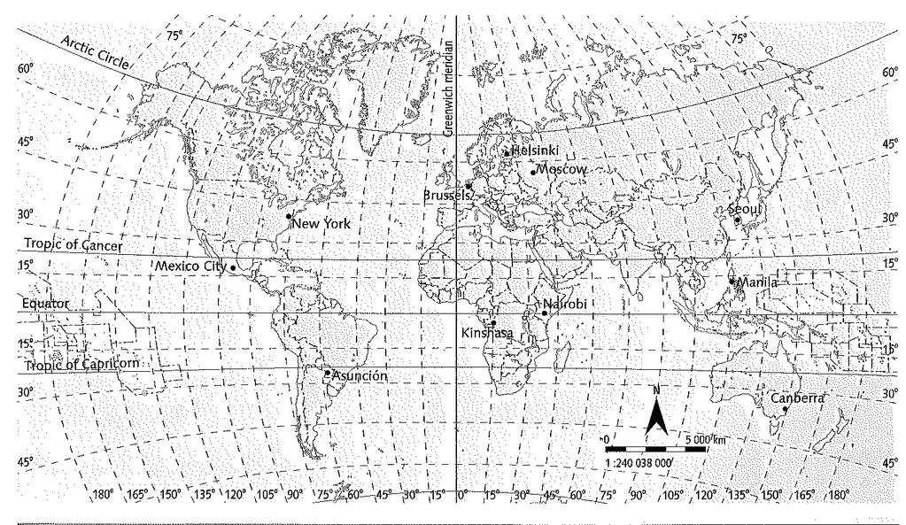
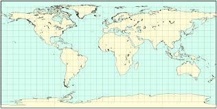
19 3. Lines and geographic coordinates Geographic network: a grid of imaginary lines that can be used to determine the location of a place on the surface of the Earth. This lines are: Parallels: imaginary parallel circles perpendicular to the Earth s axis. They are drawn around the Earth from East to West. The reference parallel is the Equator, or parallel 0º.
20 3. Lines and geographic coordinates The other principal parallels are: o The Tropic of Cancer o The Arctic Circle o The Tropic of Capricorn o The Antarctic Circle

21 3. Lines and geographic coordinates
22 3. Lines and geographical coordinates Meridians: imaginary semicircles drawn from the North Pole to the South Pole. The prime meridian is meridian 0º or Greenwich meridian. The number of meridians that can be drawn could be infinite. Maps always show meridians every 5⁰, 10⁰, 15⁰ or 20⁰

23 3. Lines and geographic coordinates
24 3. Lines and geographic coordinates Geographic coordinates To find a place on the surface of the Earth we have to know its geographic coordinates, which are its latitude and longitude. Latitude: the distance between any point on the Earth s surface and the Equator. It is measured in degrees north or south. Its value is between 0º and 90º.
25 3. Lines and geographic coordinates Geographic coordinates Longitude: the distance between any point on the Earth s surface and the Greenwich meridian. It is measured in degrees east or west. Its value is between 0º and 180º.

26 3. Lines and geographic coordinates Latitude

27 3. Lines and geographic coordinates Longitude

28 3. Lines and geographic coordinates Latitude and longitude grid


29 ACTIVITIES 5. Write the correct name of each imaginary line in the box:
30 ACTIVITIES
31

32 4. Time zones
 PLANAR")

33 5. Representation of the Earth CYLINDRICAL PROJECTION EQUATOR (And the whole world) PLANAR PROJECTION THE POLES CONICAL PROJECTION THE MIDDLE LATITUDES (between the tropics and the polar circles)

34 5. Representation of the Earth
35 5. Representation of the Earth
36 THE END By José Luis Alcaide Juárez Geography & History teacher IES Puerta de la Axarquía
THE EARTH AND ITS REPRESENTATION
 UNIT 7 THE EARTH AND ITS REPRESENTATION TABLE OF CONTENTS 1 THE EARTH AND THE SOLAR SYSTEM... 2 2 THE EARTH S MOVEMENTS... 2 2.1 Rotation.... 2 2.2 The revolution of the Earth: seasons of the year....
The Earth and its representation
 GEOGRAPHY UNIT 1 The Earth and its representation THE SOLAR SYSTEM AND THE EARTH THE SOLAR SYSTEM The solar system is a planetary system. Is a group of astronomical objects who surround a star, in this
The Earth is a Rotating Sphere
 The Earth is a Rotating Sphere The Shape of the Earth Earth s Rotation ( and relative movement of the Sun and Moon) The Geographic Grid Map Projections Global Time The Earth s Revolution around the Sun
Module 2: Mapping Topic 2 Content: Determining Latitude and Longitude Notes
 Introduction In order to more easily locate points on a globe or map, cartographers designed a system of imaginary vertical lines (also called parallels) and horizontal lines (also called meridians) that
Chapter 1 Introduction to the Earth
 Chapter 1 Introduction to the Earth What is Geography? The study of the earth as the home of humankind. Greek - Eratosthenes Father of Geography Geo means Earth Graphy means to write Study how things are
November 20, NOTES ES Rotation, Rev, Tilt.notebook. vertically. night. night. counterclockwise. counterclockwise. East. Foucault.
 NOTES ES, Rev,.notebook, and Rotates on an imaginary axis that runs from the to the South North Pole Pole vertically North The of the axis points to a point in space near day Pole Polaris night Responsible
Latitude and Longitude. Begin
 Latitude and Longitude Begin The Earth is divided in two halves, the top half is called the northern hemisphere, and the bottom half is called the southern hemisphere. The dividing line between the two
Practice Seasons Moon Quiz
 1. Which diagram represents the tilt of Earth's axis relative to the Sun's rays on December 15? A) B) C) D) 2. The diagram below represents Earth in space on the first day of a season. 5. Base your answer
Lecture #03. January 20, 2010, Wednesday
 Lecture #03 January 20, 2010, Wednesday Causes of Earth s Seasons Earth-Sun geometry Day length Solar angle (beam spread) Atmospheric beam depletion Shape and Size of the Earth North Pole E Geoid: not
STANDARD. S6E1 d. Explain the motion of objects in the day/night sky in terms of relative position.
 STANDARD S6E1 d. Explain the motion of objects in the day/night sky in terms of relative position. S6E2 b. Explain the alignment of the earth, moon, and sun during solar and lunar eclipses. c. Relate the
Reasons for the seasons - Rebecca Kaplan
 Reasons for the seasons - Rebecca Kaplan https://www.youtube.com/watch?v=dd_8jm5ptlk https://www.timeanddate.com/worldclock/sunearth.html https://www.time.gov/ https://www.space.com/33790-harvest-moon-guide.html
The following terms are some of the vocabulary that students should be familiar with in order to fully master this lesson.
 Lesson 211: EARTH'S SEASONS Students learn the complex geometry and planetary motions that cause Earth to have four distinct seasons. Fundamental Questions Attempting to give thorough and reasonable answers
Some of these parallels are very important. In the Northern Hemisphere, there is the Tropic of Cancer and the Arctic Circle.
 PDF 2 Geographic coordinates 1 The geographic coordinates system is network of imaginary horizontal and vertical lines that are drawn on globes or maps. These lines are called parallels (lines of latitude)
Earth s Orbit. Sun Earth Relationships Ridha Hamidi, Ph.D. ESCI-61 Introduction to Photovoltaic Technology
 1 ESCI-61 Introduction to Photovoltaic Technology Sun Earth Relationships Ridha Hamidi, Ph.D. Spring (sun aims directly at equator) Winter (northern hemisphere 23.5 tilts away from sun) 2 Solar radiation
Downloaded from
 Geo Globe : Latitudes and Longitudes 1.Suppose the time at 30 east is 2 p.m. then what is the time at Greenwich? (A) 2 p.m. (B) 12 p.m. (C) 1 p.m. (D) Cannot find 2.What does the term 'Grid' mean
PHYSICAL GEOGRAPHY. By Brett Lucas
 PHYSICAL GEOGRAPHY By Brett Lucas INTRODUCTION Introduction to Earth Geography as a Field of Learning Geography is from two Greek words, Geo Earth, and Graphien to write. Elements/Branches of Geography
SUBJECT : GEOGRAPHY ROTATION AND REVOLUTION This paper consists of 5 printed pages.
 SUBJECT : GEOGRAPHY ROTATION AND REVOLUTION 2017-2018 This paper consists of 5 printed pages. 1. Name the motions of the earth. A. They are Rotation and Revolution. 2. What is Rotation? A. Rotation is
Chapter 1 Test on Geography Skills
 Name Score Chapter 1 Test on Geography Skills Part 1 Matching (14 pts.) Match each term in Column B with its correct definition in Column A by clearly writing the number in the blank space provided. Two
The Earth-Moon-Sun System
 chapter 7 The Earth-Moon-Sun System section 2 Time and Seasons What You ll Learn how to calculate time and date in different time zones how to distinguish rotation and revolution what causes seasons Before
Geography Class 6 Chapters 3 and
 CHAPTER 3 MOTIONS OF THE EARTH The Earth is always travelling in Space. That makes each person on Earth, a Space Traveller. No one feels the movement of the Earth because humans are too tiny when compared
Aim: What causes Seasons?
 Notepack 28 Aim: What causes Seasons? Do Now: What is the difference between revolution and rotation? Earth s rotation The Earth rotates on its axis (imaginary vertical line around which Earth spins) every
Chapter: The Earth-Moon-Sun System
 Chapter 7 Table of Contents Chapter: The Earth-Moon-Sun System Section 1: Earth in Space Section 2: Time and Seasons Section 3: Earth s Moon 1 Earth in Space Earth s Size and Shape Ancient Measurements
1/3/12. Chapter: The Earth-Moon-Sun System. Ancient Measurements. Earth s Size and Shape. Ancient Measurements. Ancient Measurements
 // Table of Contents Chapter: The Earth-Moon-Sun System Section : Chapter 7 Section : Section : Earth s Size and Shape Ancient Measurements First, no matter where you are on Earth, objects fall straight
L.O: EARTH'S 23.5 DEGREE TILT ON ITS AXIS GIVES EARTH ITS SEASONS March 21 (SPRING), June 21(SUMMER), Sept 22 (AUTUMN) & Dec 21(WINTER)
, June 21(SUMMER), Sept 22 (AUTUMN) & Dec 21(WINTER)") L.O: EARTH'S 23.5 DEGREE TILT ON ITS AXIS GIVES EARTH ITS SEASONS March 21 (SPRING), June 21(SUMMER), Sept 22 (AUTUMN) & Dec 21(WINTER) 1. The apparent daily path of the Sun changes with the seasons because
L.O: EARTH'S 23.5 DEGREE TILT ON ITS AXIS GIVES EARTH ITS SEASONS March 21 (SPRING), June 21(SUMMER), Sept 22 (AUTUMN) & Dec 21(WINTER) 1. The apparent daily path of the Sun changes with the seasons because
Introduction to Geography
 Introduction to Geography ropic of Cancer 3½ N Arctic Circle 90 N Prime Meridian 0 Arctic Ocean Mississippi R. Appalachian Mts. Europe Rocky Mountains N. America Atlantic Gulf of Ocean Mexico Caribbean
7a LATITUDE LONGITUDE.notebook. September 19, 2017
 1 PANGEA Add a pangea link to here 2 There are 4 hemispheres Hemispheres are divided using the Equator (north and south) and Prime Meridian (west and east) 3 4 Northern Hemisphere Equator SOUTHERN OCEAN
Map Skills Unit. Note taking unit
 Map Skills Unit Note taking unit Introduction To learn about the Earth, we are going to learn about two geographic tools you can use.globes and maps. Globe A globe is a round model of the planet Earth
Seasons & Time.
 Seasons & Time Earth s Movements Rotation Movement of Earth Around the Sun Elliptical Orbit Revolution 24 Hours (1 Day) 365 Days (1 Year) The Earth s Revolution & the Tilt of the axis cause variations
Astronomy 122 Section 1 TR Outline. The Earth is Rotating. Question Digital Computer Laboratory
 Astronomy 122 Section 1 TR 1300-1350 Outline 1320 Digital Computer Laboratory Leslie Looney Phone: 244-3615 Email: lwlw@wuiucw. wedu Office: Astro Building #218 Office Hours: T 10:30-11:30 a.m. or by appointment
01) The Sun s rays strike the surface of the Earth at 90 degrees at the on December 22.
 The Sun s rays strike the surface of the Earth at 90 degrees at the on December 22.") Package Title: Testbank Course Title: Introducing Physical Geography 6e Chapter Number: 01 Question Type: Multiple Choice 01) The Sun s rays strike the surface of the Earth at 90 degrees at the on December
Package Title: Testbank Course Title: Introducing Physical Geography 6e Chapter Number: 01 Question Type: Multiple Choice 01) The Sun s rays strike the surface of the Earth at 90 degrees at the on December
Practice Questions: Seasons #1
 1. Seasonal changes on Earth are primarily caused by the A) parallelism of the Sun's axis as the Sun revolves around Earth B) changes in distance between Earth and the Sun C) elliptical shape of Earth's
What causes Earth to have seasons?
 Seasons What causes Earth to have seasons? The distance to Earth does NOT cause seasons seasons are caused by : 1. the tilt of the earth on its axis (23.5 degrees) 2.revolution of earth around the sun
The Sun-Earth-Moon System
 chapter 311 section 1 Earth The Sun-Earth-Moon System Before You Read What do you already know about Earth s shape, its size, and how it moves? Write what you know on the lines below. What You ll Learn
The Earth, Moon, and Sky. Lecture 5 1/31/2017
 The Earth, Moon, and Sky Lecture 5 1/31/2017 From Last Time: Stable Orbits The type of orbit depends on the initial speed of the object Stable orbits are either circular or elliptical. Too slow and gravity
NAVIGATION THEORY QUESTIONS Basics of Navigation
 NAVIGATION THEORY QUESTIONS Basics of Navigation Q610065 look at it The angle between the plane of the ecliptic and the plane of equator is approx? 23.5 degrees In which two months of the year is the difference
Globes, Maps, and Atlases. Plus, A Whole Bunch of Other Way Cool Geographic Information!!!
 Globes, Maps, and Atlases Plus, A Whole Bunch of Other Way Cool Geographic Information!!! Globes Are the Most Accurate Portrayal of the Earth The earth is about 24,900 miles in circumference, and about
THE EARTH. Some animals and plants live in water. Many animals, plants and human beings live on land.
 THE EARTH The Earth is our planet. It is round and it looks blue from space. The Earth has everything that living beings need: air, water, and heat and light from the Sun. On our planet there is water,
Appearance of the Sky Orientation Motion of sky Seasons Precession (?)
") Today Appearance of the Sky Orientation Motion of sky Seasons Precession (?) The Celestial Sphere Stars at different distances all appear to lie on the celestial sphere. The ecliptic is the Sun s apparent
Today Appearance of the Sky Orientation Motion of sky Seasons Precession (?) The Celestial Sphere Stars at different distances all appear to lie on the celestial sphere. The ecliptic is the Sun s apparent
Planet Earth. Part 2
 Planet Earth Part 2 Sun, Earth and Moon Motions The Solar System revolves around the Milky Way galaxy center. The Sun rotates on its own axis. Earth revolves around the Sun (1 year) and rotates on its
C) D) 2. The model below shows the apparent path of the Sun as seen by an observer in New York State on the first day of one of the four seasons.
 D) 2. The model below shows the apparent path of the Sun as seen by an observer in New York State on the first day of one of the four seasons.") 1. Which diagram best represents the regions of Earth in sunlight on June 21 and December 21? [NP indicates the North Pole and the shading represents Earth's night side. Diagrams are not drawn to scale.]
1. Which diagram best represents the regions of Earth in sunlight on June 21 and December 21? [NP indicates the North Pole and the shading represents Earth's night side. Diagrams are not drawn to scale.]
Full name:.. Date:. School: Teacher:
 CONTENTS: 1. The solar system 2. The representation of the Earth 3. The cardinal points 4. The geographical coordinates 5. The scale 6. Earth movements Full name:.. Date:. Class: School: Teacher: A Asteroid:
HOW TO TRAVEL ON EARTH WITHOUT GETTING LOST
 HOW TO TRAVEL ON EARTH WITHOUT GETTING LOST Using a globe to learn how a position on Earth can be described. Rui Dilão, Instituto Superior Técnico Curriculum topic latitude, longitude, coordinate system
Weather Dynamics. Amazing Weather!
 Lesson1Weather Hurricane Igor, St. John's, 2010 Tsunami, Japan, 2011 Amazing Weather! Weather Dynamics Weather Dynamics is the study of how the movement of water and air causes weather patterns. The main
Appearance of the Sky Orientation Motion of sky Seasons Precession (?)
") Today Appearance of the Sky Orientation Motion of sky Seasons Precession (?) The Celestial Sphere Stars at different distances all appear to lie on the celestial sphere. The ecliptic is the Sun s apparent
Today Appearance of the Sky Orientation Motion of sky Seasons Precession (?) The Celestial Sphere Stars at different distances all appear to lie on the celestial sphere. The ecliptic is the Sun s apparent
Seasons. What causes the seasons?
 Questions: Seasons What causes the seasons? How do we mark the progression of the seasons? What is the seasonal motion of the sun in the sky? What could cause the seasonal motion of the sun to change over
Daylight Data: Days and Nights Around the World
 Days & Nights 1 Name Daylight Data: Days and Nights Around the World Purpose: To investigate the number of hours of daylight received by countries at different latitudes. Materials: Daylight data sheet
Complete the following: a. Lines of latitude are parallel to the equator. Name:
 Name: Date: Social Studies Introduction: Basic Geography Period: Latitude Latitude is defined as a measurement of distance in degrees north and south of the equator. The word latitude is derived from the
Geographic Grid -Latitudes and Longitudes
 GEOGRAPHY STD 9 Geographic Grid -Latitudes and Longitudes 2018-2019 Q1. Define Geographic Grid. The network of latitudes and longitudes are known as Geographic Grid. They help us to locate places on the
Rotation and Revolution
 On Earth, each day begins at sunrise and ends at sunset. You see the Sun come up or rise in the morning and go down or set at night. When we use these phrases, what do you think they imply about the way
This clementine orange is an oblate spheroid. Earth is more rounded than this clementine, but it is still an oblate spheroid.
 On Earth, each day begins at sunrise and ends at sunset. You see the Sun come up or rise in the morning and go down or set at night. When we use these phrases, what do you think they imply about the way
INTERNATIONAL INDIAN SCHOOL, RIYADH HALF YEARLY
 INTERNATIONAL INDIAN SCHOOL, RIYADH HALF YEARLY 2018-19 STD V Fill in the blanks: WORKSHEET LESSON - 1 KNOW YOUR PLANET SOCIAL STUDIES 1 A book containing maps is called an _ 2 A Flemish map maker, collection
astronomy A planet was viewed from Earth for several hours. The diagrams below represent the appearance of the planet at four different times.
 astronomy 2008 1. A planet was viewed from Earth for several hours. The diagrams below represent the appearance of the planet at four different times. 5. If the distance between the Earth and the Sun were
Earth Moon Motions A B1
 Earth Moon Motions A B1 1. The Coriolis effect provides evidence that Earth (1) rotates on its axis (2) revolves around the Sun (3) undergoes cyclic tidal changes (4) has a slightly eccentric orbit 9.
THE EARTH. MERIDIANS AND PARALLELS
 THE EARTH. MERIDIANS AND PARALLELS 1=Circle of latitude 2=Meridian (geography) A circle of latitude, on the Earth, is an imaginary east-west circle connecting all locations (not taking into account elevation)
The position of the Sun on the celestial sphere at the solstices and the equinoxes.
 1 2 3 4 5 6 7 8 9 10 11 12 13 EARTH IN SPACE Tillery, Chapter 18 Artist's concept of the solar system. Shown are the orbits of the planets, Earth being the third planet from the Sun, and the other planets
Time, coordinates and how the Sun and Moon move in the sky
 Time, coordinates and how the Sun and Moon move in the sky Using the colors and magnitudes of quasars drawn from the SDSS Catalog Archive Server to distinguish quasars from stars using the light they emit
GEOGRAPHY STD.9 LATITUDE & LONGITUDE
 GEOGRAPHY STD.9 LATITUDE & LONGITUDE 1. What is the Earth Grid? A. The complete network of meridians & parallels is called the earth Grid. 2. What is Latitude? A. The latitude of a place is the distance
Discovering the Night Sky
 Discovering the Night Sky Guiding Questions 1. What role did astronomy play in ancient civilizations? 2. Are the stars that make up a constellation actually close to one another? 3. Are the same stars
Discovering the Night Sky
 Guiding Questions Discovering the Night Sky 1. What role did astronomy play in ancient civilizations? 2. Are the stars that make up a constellation actually close to one another? 3. Are the same stars
Knowing the Heavens. Chapter Two. Guiding Questions. Naked-eye (unaided-eye) astronomy had an important place in ancient civilizations
 astronomy had an important place in ancient civilizations") Knowing the Heavens Chapter Two Guiding Questions 1. What role did astronomy play in ancient civilizations? 2. Are the stars that make up a constellation actually close to one another? 3. Are the same
Knowing the Heavens Chapter Two Guiding Questions 1. What role did astronomy play in ancient civilizations? 2. Are the stars that make up a constellation actually close to one another? 3. Are the same
Name: Earth and Space Assessment Study Guide. Assessment Date : Term Rotation Revolution
 Name: Earth and Space Assessment Study Guide Assessment Date : Earth s Rotation and Revolution Term Rotation Revolution Brief Definition Earth s Time to Complete One complete spin on an axis 24 hours (or
Introduction To Astronomy Lesson 1
 Introduction To Astronomy Lesson 1 Topics for this Lesson Earth Based Coordinates The Celestial Sphere and Sky Coordinates The North Star Measuring Distances on the Sky The Motion of Objects in the Sky
L.O: THE ANGLE OF INSOLATION ANGLE INSOLATION: THE ANGLE SUNLIGHT HITS THE EARTH
 L.O: THE ANGLE OF INSOLATION ANGLE INSOLATION: THE ANGLE SUNLIGHT HITS THE EARTH 1. The graph below shows air temperatures on a clear summer day from 7 a.m. to 12 noon at two locations, one in Florida
Earth Motions Packet 14
 Earth Motions Packet 14 Your Name Group Members Score Minutes Standard 4 Key Idea 1 Performance Indicator 1.1 Explain complex phenomena, such as tides, variations in day length, solar insolation, apparent
UNIT 3: EARTH S MOTIONS
 UNIT 3: EARTH S MOTIONS After Unit 3 you should be able to: o Differentiate between rotation and revolution of the Earth o Apply the rates of rotation and revolution to basic problems o Recall the evidence
Science4. Student s book. Natural
 Science4 Student s book Natural Contents LESSON Page VALUES COMMUNICATION AND CRITICAL SPIRIT COMPETENCES AND MULTIPLE INTELLIGENCES 1. The Earth 4 to 17 Taking care of our planet. Explaining the Solar
1. Write down the term 2. Write down the book definition 3. Put the definition in your own words 4. Draw an image and/or put a Real Life Example
 Unit 1 Vocabulary 1. Write down the term 2. Write down the book definition 3. Put the definition in your own words 4. Draw an image and/or put a Real Life Example Absolute Location Where Is It EXACTLY?
2. Knowing the Heavens
 2. Knowing the Heavens Ancient naked-eye astronomy Eighty-eight constellations The sky s ever-changing appearance The celestial sphere Celestial coordinates Seasons: Earth s axial tilt Precession of Earth
C) the seasonal changes in constellations viewed in the night sky D) The duration of insolation will increase and the temperature will increase.
 the seasonal changes in constellations viewed in the night sky D) The duration of insolation will increase and the temperature will increase.") 1. Which event is a direct result of Earth's revolution? A) the apparent deflection of winds B) the changing of the Moon phases C) the seasonal changes in constellations viewed in the night sky D) the
1. Which event is a direct result of Earth's revolution? A) the apparent deflection of winds B) the changing of the Moon phases C) the seasonal changes in constellations viewed in the night sky D) the
 Name Period Parent Signature Geography/Map Skills Study Guide *For extra practice with these skills, check out Mr. Kath s website: http://rkath.weebly.com/activities--links.html Continents and Oceans of
Cardinal and Intermediate Directions:
 Name Period Parent Signature Due Date: (TBA) Geography/Map Skills Study Guide Continents and Oceans of the World: Label the continents (7) and oceans (4) on the lines below the map. 1 11 3 5 4 8 2 9 10
Earth s Motion. Lesson Outline LESSON 1. A. Earth and the Sun 1. The diameter is more than 100 times greater than
 Lesson Outline Earth s Motion LESSON 1 A. Earth and the Sun 1. The diameter is more than 100 times greater than Earth s diameter. a. In the Sun, atoms combine during, producing huge amounts of energy.
Solar System Test - Grade 5
 Solar System Test - Grade 5 Multiple Choice Directions: Identify the choice that best completes the statement or answers the question. Write this answer on your answer document. 1. The tilt of Earth s
ME 476 Solar Energy UNIT THREE SOLAR RADIATION
 ME 476 Solar Energy UNIT THREE SOLAR RADIATION Unit Outline 2 What is the sun? Radiation from the sun Factors affecting solar radiation Atmospheric effects Solar radiation intensity Air mass Seasonal variations
Map Skills and Geographic Tools
 Name: Period: Map Skills and Geographic Tools TEKS: 8.9C interpret topographic maps and satellite views to identify land and erosional features and predict how these features may be reshaped by weathering
Chapter 1 Section 2. Land, Water, and Climate
 Chapter 1 Section 2 Land, Water, and Climate Vocabulary 1. Landforms- natural features of the Earth s land surface 2. Elevation- height above sea level 3. Relief- changes in height 4. Core- most inner
EARTHS SHAPE AND POLARIS PRACTICE 2017
 1. In the diagram below, letters A through D represent the locations of four observers on the Earth's surface. Each observer has the same mass. 3. Which diagram most accurately shows the cross-sectional
AUSTRALIAN HOMESCHOOLING SERIES SAMPLE. Earth and Space. Secondary Science 7C. Years 7 9. Written by Valerie Marett. CORONEOS PUBLICATIONS Item No 544
 AUSTRALIAN HOMESCHOOLING SERIES Earth and Space Secondary Science 7C Years 7 9 Written by Valerie Marett CORONEOS PUBLICATIONS Item No 544 Secondary Science Earth and Space Contents The Earth. 2 Movements
Astronomy#2 - Notebook
 Name Test Date Hour Astronomy#2 - Notebook Planet Earth LEARNING TARGETS I can describe a sphere and give evidence used to prove Earth is spherical. I can explain the difference between rotation and revolution.
Latitude and Longitude Pre Test
 Name Date Latitude and Longitude Pre Test Multiple Choice Directions: For questions, 1 10 circle the answer that letter that best answers the question. Each question is worth 1 point each. 1. To locate
Know the Lingo LATITUDE LONGITUDE
 Station Alpha SS.6.G.1.1 Use latitude and longitude coordinates to understand the relationship between people and places on the Earth - - - - - - - - - - - - - - - - - - - - - - - - - - - Know the Lingo
Cartesian Coordinates Need two dimensional system 2 number lines perpendicular to each other X-axis is horizontal Y-axis is vertical Position relative
 General Physical Science Chapter 15 Place and Time Space and Time Einstein Space and time related Single entity Time is the 4 th dimension! Cartesian Coordinates Need some system to tell us where something
Mapping Earth s Surface Chapter 2 Section 3
 Mapping Earth s Surface Chapter 2 Section 3 Day 1 Objective I will understand maps can be used to find locations on Earth and to represent information about features on Earth s Surface I will understand
Fundamentals of Satellite technology
 Fundamentals of Satellite technology Prepared by A.Kaviyarasu Assistant Professor Department of Aerospace Engineering Madras Institute Of Technology Chromepet, Chennai Orbital Plane All of the planets,
Complete Geography Overview: Year 1 to Year 6
 Option 1 Complete Geography Overview: Year 1 to Year 6 Autumn Term Spring Term Summer Term Year 1 Where do I live? Around the World The Four Seasons Year 2 At the Farm Let s go on Safari My World and Me
Introduction to Geography
 Introduction to Geography What is geography? Geography comes from the Greek word Geographia. Geo means earth and graphia means to describe or chart. Geographers study the earth in relation to space and
Summary Sheet #1 for Astronomy Main Lesson
 Summary Sheet #1 for Astronomy Main Lesson From our perspective on earth The earth appears flat. We can see half the celestial sphere at any time. The earth s axis is always perpendicular to the equator.
Year 1 name and locate the four countries and capital cities of the United Kingdom and its surrounding seas
 Long Term Objective Organisation for Geography Please note that only statutory requirements should be included in this document; any supplementary guidance and information should be retained by Subject
Chapter 3 Models of the Earth. 3.1 Finding Locations on the Earth. 3.1 Objectives
 Chapter 3 Models of the Earth 3.1 Finding Locations on the Earth 3.1 Objectives Explain latitude and longitude. How can latitude and longitude be used to find locations on Earth? How can a magnetic compass
Day, Night, Year, and Seasons
 Welcome Astronomers to the Sun, Moon, and Earth! The relationship between the Sun, Moon, and Earth is very important to the existence of life on Earth. Our quest is to find out how their relationships
MOTIONS OF THE EARTH. Figure 3.1 : Inclination of the Earth s axis and the orbital plane. Figure 3.2 : Day and Night on the Earth due to rotation
 3 Let s Do Take a ball to represent the earth and a lighted candle to represent the sun. Mark a point on the ball to represent a town X. Place the ball in such a way that the town X is in darkness. Now
Chapter S1 Celestial Timekeeping and Navigation. How do we define the day, month, year, and planetary time periods?
 Chapter S1 Celestial Timekeeping and Navigation S1.1 Astronomical Time Periods Our goals for learning:! How do we define the day, month, year, and planetary time periods?! How do we tell the time of day?!
Lesson 20: The Earth in its Orbit
 291 Lesson 20: The Earth in its Orbit Recall that the Earth s orbit around the un is an ellipse which is almost a perfect circle. The average distance from the un to the Earth is 152,100,000 km (to the
Section. 1 Our Planet, Earth. Prepare to Read
 1 Section Step-by-Step Instruction Objectives Social Studies 1. Learn about Earth s movement in relation to the sun. 2. Explore seasons and latitude. Reading/Language Arts Use context clues from surrounding
... Europe. Based on Bloom s Taxonomy. Environment Interactions Movement. Human & Location. Regions. Place
 ... Europe Location Place Human & Environment Interactions Movement Regions LEVEL 1 Knowledge Match Show or Label List Information Recall Details (5Ws + H) Find Information LEVEL 2 Comprehension Describe
Meteorology Pretest on Chapter 2
 Meteorology Pretest on Chapter 2 MULTIPLE CHOICE 1. The earth emits terrestrial radiation a) only at night b) all the time c) only during winter d) only over the continents 2. If an imbalance occurs between
Downloaded from
 I II III IV V VI Define the following terms:- a) Orbitb) Meteoroids c) Celestial bodies GEOGRAPHY ASSIGNMENTS The Earth In The Solar System d) Satellite e) Comets Give one word answers:- a) Blue planet
Chapter 1: Discovering the Night Sky. The sky is divided into 88 unequal areas that we call constellations.
 Chapter 1: Discovering the Night Sky Constellations: Recognizable patterns of the brighter stars that have been derived from ancient legends. Different cultures have associated the patterns with their
Section 2. Locating Astronomical Objects in the Night Sky What Do You See? What Do You See? Think About It. Investigate.
 Section 2 Locating Astronomical Objects in the Night Sky Section 2 Locating Astronomical Objects in the Night Sky What Do You See? What Do You See? Learning Outcomes In this section, you will Construct
5 - Seasons. Figure 1 shows two pictures of the Sun taken six months apart with the same camera, at the same time of the day, from the same location.
 ASTR 110L 5 - Seasons Purpose: To plot the distance of the Earth from the Sun over one year and to use the celestial sphere to understand the cause of the seasons. What do you think? Write answers to questions