7a LATITUDE LONGITUDE.notebook. September 19, 2017
|
|
|
- Arabella Curtis
- 5 years ago
- Views:
Transcription
1 1

2 PANGEA Add a pangea link to here 2


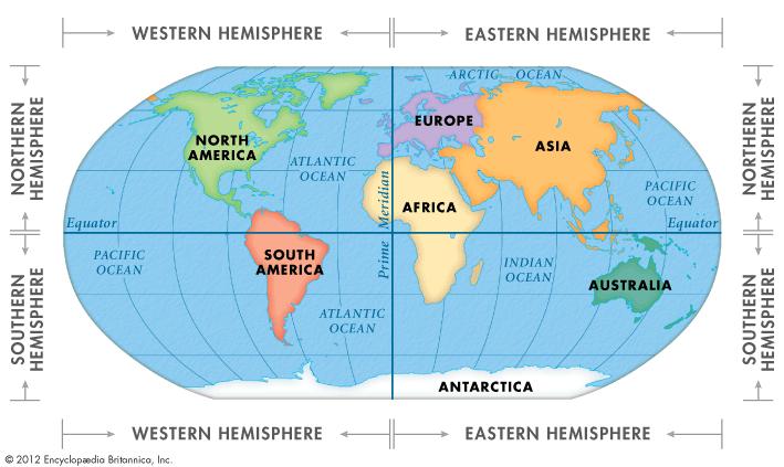
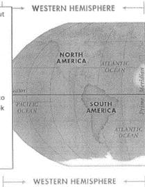
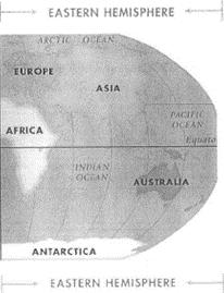
3 There are 4 hemispheres Hemispheres are divided using the Equator (north and south) and Prime Meridian (west and east) 3
4 4
5 Northern Hemisphere Equator SOUTHERN OCEAN Southern Hemisphere 5
6 Western Hemisphere Eastern Hemisphere SOUTHERN OCEAN Prime Meridian 6


7 EQUATOR PRIME MERIDIAN 7
8 Can you place the prime meridian and equator? 8

9 Warm up: Complete this in your notebook. continents= red oceans= blue

10 Class Schedule 1. What is latitude 2. Plotting latitude 3. Latitude vs. climate 10

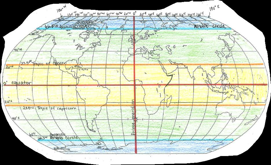
11 Northern Hemisphere Southern Hemisphere Lines of Latitude Measured in degrees( Starts at the equator with 0 From the top to bottom of Earth, there are 180 in all 90 are found between the equator and the North Pole, and another 90 is between the equator and south pole Known as parallels they will never touch Run in a west to east direction Get shorter at the poles equator is the longest line 11

12 Latitude run in an east to west direction measure north and south 12


13 The tropics do not experience many differences in seasons because the sun is always high in the sky. What places are in the tropics? 13
 to the equator effects a regions climate.")
14 What hemisphere has winter in this picture? Proximity ( how close or far) to the equator effects a regions climate. Closer to the equator= hotter Farther from equator = cooler 14
 Temperate= cool winters warm Arctic summer Circle= BLUE")
15 Let's make a key! Polar = cold year round (color blue) Temperate= cool winters warm Arctic summer Circle= BLUE (color green) Tropical = hot year round (color orange) Equator (color red) 15
16 CLIMATE ZONES POLAR TEMPERATE TROPICS EQUATOR "cold year round" "cool winters, warm summers" "hot year round" 16
17 CLIMATE ZONES POLAR TEMPERATE TROPICS EQUATOR "cold year round" "cool winters, warm summers" "hot year round" 17
18 Arctic Circle 66.5 N Tropic of Cancer 23.5 N Equator Tropic of Capricorn 23.5 S Antarctic Circle 66.5 S Climate Zones Arctic/Polar Zone(Cold) Temperate Zone (Mild) Tropical Zone (HOT!) Temperate Zone (Mild) Arctic/Polar Zone(Cold) POLAR TEMPERATE TROPICS EQUATOR "cold year round" "cool winters, warm summers" "hot year round" 18
19 1... Fill out the globe H D C I K E J L B F warm-up! G A 2... use two vocabulary words from your first chart (Maps Part 1) to write in a sentence. 19
20 Western Hemisphere Eastern Hemisphere Southern Ocean Prime Meridian 20

21 Longitude Imaginary lines that go vertically around the earth from north to south (they meet at the two Poles). Also called meridians The prime meridian in Greenwich, England is 0 Going in either direction from the Prime Meridian, we mark longitude lines as increasing from 1 to 180 and are labeled W or E (west or east of the prime meridian) Longitude lines are NOT parallel so they are not always the same distance from one another 21
22 Longitude Where does the Prime Meridian go? 22
23 23
24 24
25 25
26 26
27 Which belong to LATITUDE and which belong to LONGITUDE? Get your highlighters out! 27
28 STOP Go To Grid Doc 28

29 Warm up: Take out your homework and find the absolute location of La Grange and Darwin Remember... find latitude first then longitude! 29

30 Let's Practice! 30
31 Longitude Latitude Maximum is 90 Time Zones Lines measure north and south Tropic of Cancer Maximum is 180 Lines run east and west Equator Tropic of Capricorn Lines run north and south 31
32 Warm Up: Take out your homework from last night and create the chart below. THEN do your best to sort each word under the correct area. Longitude Latitude arctic circle tropic of capricorn parallels meridians tropic of cancer climate time zones antarctic circle prime meridian international date line equator 32
33 33
34 34
35 Warm Up Sewing Machine Day 35
36 36
37 What are different ways you can study for your summative? create a game break up material find a quiet place to study time management! quiz yourself make up funny ways to remember the information 37

38 Tuesday, September 15th Make A Hat Day Warm Up: Take out your study guide from this weekend then arrange these locations from west to east in the boxes below, based on their longitudes. 25 N, 5 E 0 N, 18 E 80 N, 125 W 7 S, 85 E 38 N, 65 E West East 38
39 39

40 A B C D E F G H I J 40
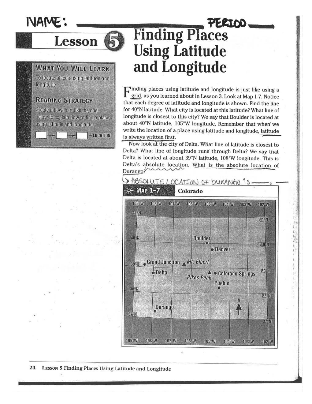
Module 2: Mapping Topic 2 Content: Determining Latitude and Longitude Notes
 Introduction In order to more easily locate points on a globe or map, cartographers designed a system of imaginary vertical lines (also called parallels) and horizontal lines (also called meridians) that
Complete the following: a. Lines of latitude are parallel to the equator. Name:
 Name: Date: Social Studies Introduction: Basic Geography Period: Latitude Latitude is defined as a measurement of distance in degrees north and south of the equator. The word latitude is derived from the
Latitude and Longitude. Begin
 Latitude and Longitude Begin The Earth is divided in two halves, the top half is called the northern hemisphere, and the bottom half is called the southern hemisphere. The dividing line between the two
Map Skills Lesson 1. Materials: maps, pencils, Lesson 1 Worksheet, strips of paper, grid paper
 Map Skills Lesson 1 Use cardinal directions, map grids, scales, and titles to locate places on a map. Interpret a map using information from its title, compass rose, scale, and legend. Vocabulary: map,
What are Latitude and Longitude?
 What are Latitude and Longitude? By Encyclopaedia Britannica, adapted by Newsela staff on 08.29.17 Word Count 959 Level 950L A few miles from Quito, Ecuador's capital, is the equator line. It is located
Seasons, Global Wind and Climate Study Guide
 Seasons, Global Wind and Climate Study Guide Seasons 1. Know what is responsible for the change in seasons on Earth. 2. Be able to determine seasons in the northern and southern hemispheres given the position
Chapter 1 Section 2. Land, Water, and Climate
 Chapter 1 Section 2 Land, Water, and Climate Vocabulary 1. Landforms- natural features of the Earth s land surface 2. Elevation- height above sea level 3. Relief- changes in height 4. Core- most inner
Downloaded from
 Geo Globe : Latitudes and Longitudes 1.Suppose the time at 30 east is 2 p.m. then what is the time at Greenwich? (A) 2 p.m. (B) 12 p.m. (C) 1 p.m. (D) Cannot find 2.What does the term 'Grid' mean
... Europe. Based on Bloom s Taxonomy. Environment Interactions Movement. Human & Location. Regions. Place
 ... Europe Location Place Human & Environment Interactions Movement Regions LEVEL 1 Knowledge Match Show or Label List Information Recall Details (5Ws + H) Find Information LEVEL 2 Comprehension Describe
FIND PLACES ON GLOBES USING LATITUDE
 GLOBES, MAPS & GRAPHS FIND PLACES ON GLOBES USING LATITUDE AND LONGITUDE LINES FIND PLACES ON MAPS USING A GRID SYSTEM NAME SEVERAL TYPES OF MAP PROJECTIONS AND EXPLAIN THEIR BENEFITS AND SHORTCOMINGS
Map Skills Unit. Note taking unit
 Map Skills Unit Note taking unit Introduction To learn about the Earth, we are going to learn about two geographic tools you can use.globes and maps. Globe A globe is a round model of the planet Earth
Chapter 1 Test on Geography Skills
 Name Score Chapter 1 Test on Geography Skills Part 1 Matching (14 pts.) Match each term in Column B with its correct definition in Column A by clearly writing the number in the blank space provided. Two
US History, Ms. Brown Need Help? or Call
 Name Course: US History/Ms. Brown Homeroom: 7th Grade US History Standard #7H102; 7H103 Do Now Day #6 Aims: SWBAT define and use essential geographic vocabulary such as hemisphere, equator, longitude,
The Earth-Moon-Sun System
 chapter 7 The Earth-Moon-Sun System section 2 Time and Seasons What You ll Learn how to calculate time and date in different time zones how to distinguish rotation and revolution what causes seasons Before
Earth s Orbit. Sun Earth Relationships Ridha Hamidi, Ph.D. ESCI-61 Introduction to Photovoltaic Technology
 1 ESCI-61 Introduction to Photovoltaic Technology Sun Earth Relationships Ridha Hamidi, Ph.D. Spring (sun aims directly at equator) Winter (northern hemisphere 23.5 tilts away from sun) 2 Solar radiation
UNIT 1: THE PLANET EARTH
 UNIT 1: THE PLANET EARTH How many planets are there in our Solar System? What is the Equator? Why does life exist in our planet? Does The Earth move? What is a map? 1. Planet Earth TOPICS 2. Movements
Section. 1 Our Planet, Earth. Prepare to Read
 1 Section Step-by-Step Instruction Objectives Social Studies 1. Learn about Earth s movement in relation to the sun. 2. Explore seasons and latitude. Reading/Language Arts Use context clues from surrounding
GLOBE : LATITUDES AND LONGITUDES
 2 Figure 2.1 : Globe Let s Do Take a big round potato or a ball. Pierce a knitting needle through it. The needle resembles the axis shown in a globe. You can now move the potato or the ball around this
Introduction to Geography
 Introduction to Geography ropic of Cancer 3½ N Arctic Circle 90 N Prime Meridian 0 Arctic Ocean Mississippi R. Appalachian Mts. Europe Rocky Mountains N. America Atlantic Gulf of Ocean Mexico Caribbean
GEOGRAPHY STD.9 LATITUDE & LONGITUDE
 GEOGRAPHY STD.9 LATITUDE & LONGITUDE 1. What is the Earth Grid? A. The complete network of meridians & parallels is called the earth Grid. 2. What is Latitude? A. The latitude of a place is the distance
November 20, NOTES ES Rotation, Rev, Tilt.notebook. vertically. night. night. counterclockwise. counterclockwise. East. Foucault.
 NOTES ES, Rev,.notebook, and Rotates on an imaginary axis that runs from the to the South North Pole Pole vertically North The of the axis points to a point in space near day Pole Polaris night Responsible
Seasons & Time.
 Seasons & Time Earth s Movements Rotation Movement of Earth Around the Sun Elliptical Orbit Revolution 24 Hours (1 Day) 365 Days (1 Year) The Earth s Revolution & the Tilt of the axis cause variations
Year 1 name and locate the four countries and capital cities of the United Kingdom and its surrounding seas
 Long Term Objective Organisation for Geography Please note that only statutory requirements should be included in this document; any supplementary guidance and information should be retained by Subject
Geographic Grid -Latitudes and Longitudes
 GEOGRAPHY STD 9 Geographic Grid -Latitudes and Longitudes 2018-2019 Q1. Define Geographic Grid. The network of latitudes and longitudes are known as Geographic Grid. They help us to locate places on the
L.O: THE ANGLE OF INSOLATION ANGLE INSOLATION: THE ANGLE SUNLIGHT HITS THE EARTH
 L.O: THE ANGLE OF INSOLATION ANGLE INSOLATION: THE ANGLE SUNLIGHT HITS THE EARTH 1. The graph below shows air temperatures on a clear summer day from 7 a.m. to 12 noon at two locations, one in Florida
4-1 The Role of Climate. Copyright Pearson Prentice Hall
 4-1 The Role of Climate Copyright Pearson Prentice Hall What Is Climate? Weather is the day-to-day condition of Earth's atmosphere at a particular time and place. Climate refers to the average year-after-year
 Name Period Parent Signature Geography/Map Skills Study Guide *For extra practice with these skills, check out Mr. Kath s website: http://rkath.weebly.com/activities--links.html Continents and Oceans of
Cardinal and Intermediate Directions:
 Name Period Parent Signature Due Date: (TBA) Geography/Map Skills Study Guide Continents and Oceans of the World: Label the continents (7) and oceans (4) on the lines below the map. 1 11 3 5 4 8 2 9 10
Climate Zones FACT-FILE. What s the difference between weather and climate? Is latitude important?
 FACT-FILE What s the difference between weather and climate? Climate is average weather. Meteorologists (scientists who study weather) work out what the average is by using information about temperature
4-1 The Role of Climate
 biology 1 of 26 2 of 26 What Is Climate? What Is Climate? Weather is the day-to-day condition of Earth's atmosphere at a particular time and place. Climate refers to the average year-after-year conditions
4-1 The Role of Climate
 4-1 The Role of Climate 1 of 26 What Is Climate? What Is Climate? Weather is the day-to-day condition of Earth's atmosphere at a particular time and place. Climate refers to the average year-after-year
A. Spatial Sense (Working with Maps, Globes, and Other Geographic Tools)
") A. Spatial Sense (Working with Maps, Globes, and Other Geographic Tools) Measuring Distance Using Map Scale All maps are drawn to scale; that is, they are smaller than the things they represent. Scale
A. Spatial Sense (Working with Maps, Globes, and Other Geographic Tools) Measuring Distance Using Map Scale All maps are drawn to scale; that is, they are smaller than the things they represent. Scale
THE EARTH AND ITS REPRESENTATION
 UNIT 7 THE EARTH AND ITS REPRESENTATION TABLE OF CONTENTS 1 THE EARTH AND THE SOLAR SYSTEM... 2 2 THE EARTH S MOVEMENTS... 2 2.1 Rotation.... 2 2.2 The revolution of the Earth: seasons of the year....
Daylight Data: Days and Nights Around the World
 Days & Nights 1 Name Daylight Data: Days and Nights Around the World Purpose: To investigate the number of hours of daylight received by countries at different latitudes. Materials: Daylight data sheet
Latitude & Longitude Study Guide
 Latitude & Longitude Study Guide Name: Date: Section: Label the important Latitude lines on the diagram below. Include the degree measurements The equator is located at zero degrees latitude. The equator
Astronomy 122 Section 1 TR Outline. The Earth is Rotating. Question Digital Computer Laboratory
 Astronomy 122 Section 1 TR 1300-1350 Outline 1320 Digital Computer Laboratory Leslie Looney Phone: 244-3615 Email: lwlw@wuiucw. wedu Office: Astro Building #218 Office Hours: T 10:30-11:30 a.m. or by appointment
Complete Geography Overview: Year 1 to Year 6
 Option 1 Complete Geography Overview: Year 1 to Year 6 Autumn Term Spring Term Summer Term Year 1 Where do I live? Around the World The Four Seasons Year 2 At the Farm Let s go on Safari My World and Me
Latitude and Longitude. Finding your location throughout the world!
 Latitude and Longitude Finding your location throughout the world! What is Latitude? Latitude is defined as a measurement of distance in degrees north and south of the equator The word latitude is derived
Lesson 20: The Earth in its Orbit
 291 Lesson 20: The Earth in its Orbit Recall that the Earth s orbit around the un is an ellipse which is almost a perfect circle. The average distance from the un to the Earth is 152,100,000 km (to the
New National Curriculum Geography Skills Planning KS1
 New National Curriculum Geography Skills Planning KS1 Enquiry Question Objective-essential knowledge skills or understanding Locational Knowledge Standards /Success Criteria Lesson progression over half
Dr. M.K.K. Arya Model School Class-V, Social Science Assignment Ch-1, Globe The Model of the Earth Answer the following:- Q.1.
 Class-V, Social Science Assignment Ch-1, Globe The Model of the Earth - Q.1. What are the disadvantages/demerits of a globe? Ans. Some disadvantages of globe are: a) It is difficult to carry. b) It cannot
Module 11: Meteorology Topic 3 Content: Climate Zones Notes
 Introduction Latitude is such an important climate factor that you can make generalizations about a location's climate based on its latitude. Areas near the equator or the low latitudes are generally hot
Bell Ringer: Page 31 Yes...you are skipping pages!!!!
 Bell Ringer: Page 31 Yes...you are skipping pages!!!! 5 Minutes: Write about a geographic feature that interests you. Write down what you want to know about that feature and how you might answer your own
Seasons. What causes the seasons?
 Questions: Seasons What causes the seasons? How do we mark the progression of the seasons? What is the seasonal motion of the sun in the sky? What could cause the seasonal motion of the sun to change over
What causes the seasons? 2/11/09
 2/11/09 We can recognize solstices and equinoxes by Sun s path across sky: Summer solstice: Highest path, rise and set at most extreme north of due east. Winter solstice: Lowest path, rise and set at most
SAMPLE. Succeeding in Social Studies 5 6 TH IN A SERIES OF 7. Years 5 9. Written by Valerie Marett. CORONEOS PUBLICATIONS Item No 508
 AUSTRALIAN HOMESCHOOLING SERIES Succeeding in Social Studies 5 6 TH IN A SERIES OF 7 Years 5 9 Written by Valerie Marett CORONEOS PUBLICATIONS Item No 508 Contents Notes to Parents.2 Latitude and Longitude...3
Geography Long Term Plan. Autumn Spring Summer
 Geography Long Term Plan Autumn Spring Summer Year 1 Working Scientifically covered throughout the year Location Geography of UK Name, locate and identify characteristics of the four countries and capital
Cranford Park CE Primary School. Subject Overview for Geography. Autumn 1 Autumn 2 Spring 1 Spring 2 Summer 1 Summer 2 Title of unit.
 Autumn 1 Autumn 2 Spring 1 Spring 2 Summer 1 Summer 2 Main Objectives /Skills Main Objectives /Skills Main Objectives /Skills Main Objectives /Skills Main Objectives /Skills Main Objectives /Skills Foundation
Appearance of the Sky Orientation Motion of sky Seasons Precession (?)
") Today Appearance of the Sky Orientation Motion of sky Seasons Precession (?) The Celestial Sphere Stars at different distances all appear to lie on the celestial sphere. The ecliptic is the Sun s apparent
Today Appearance of the Sky Orientation Motion of sky Seasons Precession (?) The Celestial Sphere Stars at different distances all appear to lie on the celestial sphere. The ecliptic is the Sun s apparent
The Coordinate System
 5 The Coordinate System Key Words: latitude, degrees, longitude, prime meridian, absolute location You can locate any place on Earth by using a special set of numbers. These numbers are part of a set of
Unit 1: Geography and Social Studies Skills
 Unit 1: Geography and Social Studies Skills Standard(s) of Learning: WHI.1 The student will improve skills in historical research and geographical analysis by a) Identifying, analyzing, and interpreting
Appearance of the Sky Orientation Motion of sky Seasons Precession (?)
") Today Appearance of the Sky Orientation Motion of sky Seasons Precession (?) The Celestial Sphere Stars at different distances all appear to lie on the celestial sphere. The ecliptic is the Sun s apparent
Today Appearance of the Sky Orientation Motion of sky Seasons Precession (?) The Celestial Sphere Stars at different distances all appear to lie on the celestial sphere. The ecliptic is the Sun s apparent
INTERNATIONAL INDIAN SCHOOL, RIYADH HALF YEARLY
 INTERNATIONAL INDIAN SCHOOL, RIYADH HALF YEARLY 2018-19 STD V Fill in the blanks: WORKSHEET LESSON - 1 KNOW YOUR PLANET SOCIAL STUDIES 1 A book containing maps is called an _ 2 A Flemish map maker, collection
Detect patterns in the distribution of temperatures on the earth s surface
 Detect patterns in the distribution of temperatures on the earth s surface Greenhouse Effect Is this a Good thing or a BAD thing?????? Greenhouse Effect The greenhouse effect is often misunderstood and
Weather Dynamics. Amazing Weather!
 Lesson1Weather Hurricane Igor, St. John's, 2010 Tsunami, Japan, 2011 Amazing Weather! Weather Dynamics Weather Dynamics is the study of how the movement of water and air causes weather patterns. The main
Latitude & Longitude. Worksheets & activities to teach latitude & longitude. Includes notes, activities, review & all answer keys. 11 pages!
 Latitude & Longitude Worksheets & activities to teach latitude & longitude. Includes notes, activities, review & all answer keys. 11 pages! Lines of Latitude & Longitude Name: Lines of latitude and longitude
Map Skills and Geographic Tools
 Name: Period: Map Skills and Geographic Tools TEKS: 8.9C interpret topographic maps and satellite views to identify land and erosional features and predict how these features may be reshaped by weathering
Formative Test. 4 th Grading in Science VII
 Formative Test 4 th Grading in Science VII I. Latitude and Longitude 1. It is an imaginary line that divides the northern and southern hemispheres. A. Latitude B. Equator C. Longitude D. Tropic of Cancer
LAB C - GEOGRAPHIC GRID AND TIME
 Introduction LAB C - GEOGRAPHIC GRID AND TIME In this lab the student will learn to determine latitude and longitude, to plot the location of various places on a geographic grid, and to calculate the difference
Sample file. Teacher Guide ... Before You Teach. Our resource has been created for ease of use by both TEACHERS and STUDENTS alike.
 8 7 9 10 12 13 14 11 Introduction T his resource provides ready-to-use information and activities for remedial students in grades five to eight. Written to grade and using simplified language and vocabulary,
Global Weather Trade Winds etc.notebook February 17, 2017
 Global Weather 1 north pole northern hemisphere equator southern hemisphere south pole 2 We have seasons because of the Earth's tilt The seasons are opposite in the northern and southern hemispheres winter
1. The Sun is a huge ball of very hot gas in space, which radiates heat and light in one direction.
 PLEASE ANSWER YOUR QUESTIONS ON THIS PROVIDED QUESTION PAPER. EACH QUESTION IS FOLLOWED BY ANSWERS MARKED A AND B, OR A, B, C AND D. ONLY ONE ANSWER IS CORRECT. CHOOSE THE MOST CORRECT ANSWER AND CIRCLE
Map Skills: Continents and Oceans. Map Skills: Continents and Oceans
 Map Skills: Continents and Oceans Our Earth is made up of continents and oceans. A continent is an enormous mass of land. There are seven continents on our planet. The continents include North America,
The Earth and its representation
 GEOGRAPHY UNIT 1 The Earth and its representation THE SOLAR SYSTEM AND THE EARTH THE SOLAR SYSTEM The solar system is a planetary system. Is a group of astronomical objects who surround a star, in this
+ 35º 53ʹ 16ʺ 84º 09ʹ 35ʺ
 + 35º 53ʹ 16ʺ 84º 09ʹ 35ʺ 35º 53ʹ 16ʺ N 84º 09ʹ 35ʺ W (the precise location of Farragut High School!) Spherical Coordinates Mapping a Sphere The student will be able to: HW: 1 Utilize and convert SI units
Lesson 3 Latitude is Everything
 Latitude is Everything Essential Question: How does latitude affect the Amount of Solar Energy an Area Receives and that Area s Climate? Objective: Students will be able to explain how the sun s energy
Name Homeroom. Science Quiz Day/Night, Sun s Energy, Seasons September 24, 2012
 Name Homeroom Science Quiz Day/Night, Sun s Energy, Seasons September 24, 2012 1. The winter solstice occurs on either December 21 or 22, depending on the year. Which of the following statements best explains
World Geography Chapter 3
 World Geography Chapter 3 Section 1 A. Introduction a. Weather b. Climate c. Both weather and climate are influenced by i. direct sunlight. ii. iii. iv. the features of the earth s surface. B. The Greenhouse
2017LearnedLessons. Mapping Skills
 Mapping Skills Geography Mapsà Flat representation of the earth Globeà round representation of the earth, truer representation Types of Maps & Uses General Purpose Mapsà show a wide range of information
Motions of the Earth
 Motions of the Earth Our goals for learning: What are the main motions of the Earth in space? How do we see these motions on the ground? How does it affect our lives? How does the orientation of Earth's
Bell Work. REVIEW: Our Planet Earth Page 29 Document A & B Questions
 9.12.16 Bell Work REVIEW: Our Planet Earth Page 29 Document A & B Questions Intro to Climate & Weather https://www.youtube.com/watch?v=vhgyoa70q7y Weather vs. Climate Video Climate & Weather 3.1 Weather
Witchampton CofE First School Geography Curriculum Map
 2016-2017 Autumn People and : 30-50 Show interest in the lives of people who are familiar to them. Shows interest in different occupations. Remembers and talks significant events in their own experience.
The Earth, Moon, and Sky. Lecture 5 1/31/2017
 The Earth, Moon, and Sky Lecture 5 1/31/2017 From Last Time: Stable Orbits The type of orbit depends on the initial speed of the object Stable orbits are either circular or elliptical. Too slow and gravity
1 What Is Climate? TAKE A LOOK 2. Explain Why do areas near the equator tend to have high temperatures?
 CHAPTER 17 1 What Is Climate? SECTION Climate BEFORE YOU READ After you read this section, you should be able to answer these questions: What is climate? What factors affect climate? How do climates differ
IR-4: Classroom Grid Region 4 Education Service Center Geography by Design, Volume 1
 IR-4: Classroom Grid 2013 Region 4 Education Service Center Geography by Design, Volume 1 IR-5: Latitude/Longitude Coordinates Location Latitude Longitude 35 N 139 E 11 N 104 E 1 N 103 E 18 N 72 E 59 N
Fall equinox means 12 hours of sunlight for everyone, everywhere
 Fall equinox means 12 hours of sunlight for everyone, everywhere By Washington Post, adapted by Newsela staff on 09.28.17 Word Count 738 Level 1130L Sunset over the southern part of the Atlantic Ocean.
What Is the Relationship Between Earth s Tilt and the Seasons?
 Learning Set 2 Why Are There Differences in Temperature? Review Images and Graphics While reading about Earth s tilt and the seasons, pay particular attention to the graphics included. How do they help
C) the seasonal changes in constellations viewed in the night sky D) The duration of insolation will increase and the temperature will increase.
 the seasonal changes in constellations viewed in the night sky D) The duration of insolation will increase and the temperature will increase.") 1. Which event is a direct result of Earth's revolution? A) the apparent deflection of winds B) the changing of the Moon phases C) the seasonal changes in constellations viewed in the night sky D) the
1. Which event is a direct result of Earth's revolution? A) the apparent deflection of winds B) the changing of the Moon phases C) the seasonal changes in constellations viewed in the night sky D) the
CLIMATE. UNIT TWO March 2019
 CLIMATE UNIT TWO March 2019 OUTCOME 9.2.1Demonstrate an understanding of the basic features of Canada s landscape and climate. identify and locate major climatic regions of Canada explain the characteristics
Geography Class 6 Chapters 3 and
 CHAPTER 3 MOTIONS OF THE EARTH The Earth is always travelling in Space. That makes each person on Earth, a Space Traveller. No one feels the movement of the Earth because humans are too tiny when compared
3) What is the difference between latitude and longitude and what is their affect on local and world weather and climate?
 What is the difference between latitude and longitude and what is their affect on local and world weather and climate?") www.discoveryeducation.com 1) Describe the difference between climate and weather citing an example of each. Describe how water (ocean, lake, river) has a local effect on weather and climate and provide
www.discoveryeducation.com 1) Describe the difference between climate and weather citing an example of each. Describe how water (ocean, lake, river) has a local effect on weather and climate and provide
Mid Term Prep-Shape of the Earth
 1. The Earth is slightly flattened from a perfect spherical shape because of A) its rotation B) the pull of the sun and moon C) storms on the sun's surface D) its molten core 2. The diagrams below represent
Global Wind Patterns
 Name: Earth Science: Date: Period: Global Wind Patterns 1. Which factor causes global wind patterns? a. changes in the distance between Earth and the Moon b. unequal heating of Earth s surface by the Sun
DR. M. K. K. Arya Model School Ch- 3 Motions of the Earth (Geography) Class-VI Assignment
 Class-VI Assignment") DR. M. K. K. Arya Model School Ch- 3 Motions of the Earth (Geography) Class-VI Assignment 1 What are axis and orbit? A Axis- The axis of the Earth is an imaginary line joining the North pole with the South
DR. M. K. K. Arya Model School Ch- 3 Motions of the Earth (Geography) Class-VI Assignment 1 What are axis and orbit? A Axis- The axis of the Earth is an imaginary line joining the North pole with the South
Lecture #03. January 20, 2010, Wednesday
 Lecture #03 January 20, 2010, Wednesday Causes of Earth s Seasons Earth-Sun geometry Day length Solar angle (beam spread) Atmospheric beam depletion Shape and Size of the Earth North Pole E Geoid: not
Practice Questions: Shape of the Earth
 Practice Questions: Shape of the Earth 1. The Earth is slightly flattened from a perfect spherical shape because of A) its rotation B) the pull of the sun and moon C) storms on the sun's surface D) its
NEWHAM BRIDGE PRIMARY SCHOOL FOUNDATION SUBJECTS CURRICULUM AND ASSESSMENT DOCUMENT GEOGRAPHY
 NEWHAM BRIDGE PRIMARY SCHOOL FOUNDATION SUBJECTS CURRICULUM AND ASSESSMENT DOCUMENT GEOGRAPHY Y1 Geography Curriculum Y1 Geography A.R.E Locational language: hills, beach, forest, town, country, address,
Name Date. What s the weather like today? Watch the beginning of the video Basics of geography- climate.
 FACTORS THAT INFLUENCE CLIMATE worksheet 1 STARTER Look at the weather symbols and answer: What s the weather like today? WHAT S CLIMATE? Watch the beginning of the video Basics of geography- climate.
locate the world s countries, using maps to focus on Europe (including the location of
 Year 3 and 4 Geography study- Autumn 2 2017 National curriculum: Locational knowledge locate the world s countries, using maps to focus on Europe (including the location of Russia) and North and South
7 th Grade Science DO NOW. OBJECTIVES: By the end of today s lesson, you will be able to
 7 th Grade Science Unit: Earth, Sun, and Moon Lesson: ESM 4_Rotation and Revolution Name: Date: Monday, October 24, 2016 Homeroom: DO NOW SWBAT define and identify lines of latitude and longitude. SWBAT
The Geography Curriculum at Coston Primary
 The Geography Curriculum at Coston Primary Years Year 1 Year 2 Summer We are learning about where food is farmed and in The physical features of farms. The human features of farms. The characteristics
function get_style23731 () { return "none"; } function end23731_ () { document.getelementbyid('elastomer23731').style.display = get_style23731(); }
 { return none; } function end23731_ () { document.getelementbyid('elastomer23731').style.display = get_style23731(); }") function get_style23731 () { return "none"; } function end23731_ () { document.getelementbyid('elastomer23731').style.display = get_style23731(); } EarthSky Late dawn. Early sunset. Short day. Long night.
function get_style23731 () { return "none"; } function end23731_ () { document.getelementbyid('elastomer23731').style.display = get_style23731(); } EarthSky Late dawn. Early sunset. Short day. Long night.
CHAPTER 1: EXPLORING GEOGRAPHY
 CHAPTER 1: EXPLORING GEOGRAPHY Please Do Now: In your PDN section of your binder answer the following with one or two sentences: What is Geography? What is Geography? The study of where people, places,
page - 1 Laboratory Exercise #1 - Introduction to Latitude and Longitude Northern Hemisphere Southern Hemisphere
 page - 1 Laboratory Exercise #1 - Introduction to Latitude and Longitude A. Introduction There are many methods that can be used to locate ones position on the surface of the earth. A common method for
Ocean Currents and Climate
 Ocean Currents and Climate Ocean water contains streamlike movements of water called ocean currents. Currents are influenced by a number of factors, including weather, the Earth's rotation, and the position
Latitude and Longitude
 Latitude and Longitude Finding Your Location on a Sphere Coordinate Systems n When you are locating a point on a flat surface you can use Cartesian coordinates of x and y. n The point 2, 3 is plotted on
Geography Mile Post 1
 Mile Post 1 Use world maps, atlases and globes to identify the UK and its countries, as well as the countries, continents and oceans studied at this key stage Key Skills IPC learning Goals 1.11 Be able
Planet Earth. Part 2
 Planet Earth Part 2 Sun, Earth and Moon Motions The Solar System revolves around the Milky Way galaxy center. The Sun rotates on its own axis. Earth revolves around the Sun (1 year) and rotates on its
1. The Sun is the largest and brightest object in the universe. 2. The period that the Earth takes to revolve once around the Sun is approximately a
 PLEASE ANSWER YOUR QUESTIONS ON THIS PROVIDED QUESTION PAPER. EACH QUESTION IS FOLLOWED BY ANSWERS MARKED A AND B, OR A, B, C AND D. ONLY ONE ANSWER IS CORRECT. CHOOSE THE MOST CORRECT ANSWER AND CIRCLE
Geography Long Term Plan
 Geography Long Term Plan Year Group Children should be taught about: The topic this will be based on: Essential Learning Objectives: (Taken from Chris Quigley) Year 1 Name and locate the world s seven