Compilation Report Hawke Hill South. Licence No M NTS 01N/06. Newfoundland and Labrador. Submitted by Gordon E. Cooper and Kevin P.
|
|
|
- Hollie Bennett
- 5 years ago
- Views:
Transcription
1
2
3 Compilation Report 2010 Hawke Hill South Licence No M NTS 01N/06 Newfoundland and Labrador Submitted by Gordon E. Cooper and Kevin P. Ryan For Kevin P. Ryan (Licence holder) January, 2011 Work Year: 1 Total Claims: 9 Total expenditures: $1,
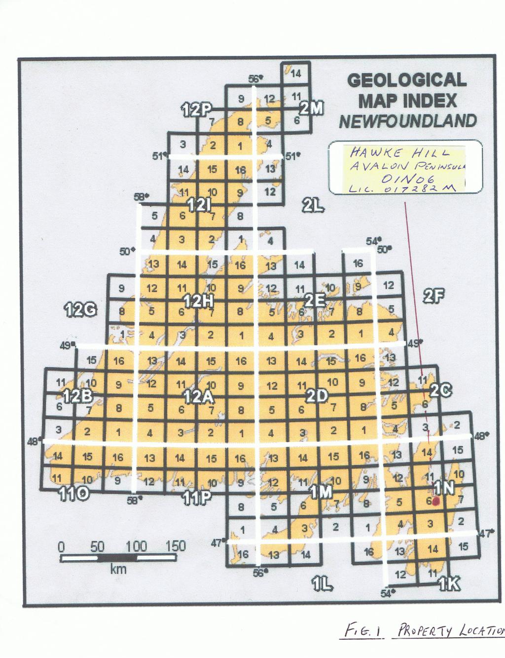
4 Table of Contents Page Introduction 3 Location and Access 3 Previous Work 3 Geology 3 Mineralization Description 4 Conclusion and Recommendations 4 References 5 List of Figures Fig. 1 Fig. 2 Fig. 3 Fig. 4 Property Location NFLD Claims Location Map Map Staked Claims Area Topographic Map List of Appendices Appendix 1 Personnel and Man Days 1 page Appendix 2 Statement of Expenditures 1 page 2
5 Introduction The subject property consists of nine claims staked for Gold under License No M and is immediately south of Licences M and M previously registered by the owner as part of the Hawke Hill Claims Group. This cumulative summary report follows a general reconnaissance visit to the northern area of the subject property by Ryan and Cooper and results from review and investigation of historical data and recent assessments available through the Government of Newfoundland and Labrador, Department of Natural Resources, Mineral Lands Division. Location and Access The subject property is situated 40 kms South West of St. John s and 2 kms south of the intersection of TCH and Route 62 on the Avalon Peninsula, NL. (re; Eastern NFLD NTS map sheet 01N/06). Access is provided by the Trans Canada Highway located to the North of the property and then by foot or ATV on existing trails. The area is largely barrens with glacial drift with sporadic outcrop, rolling hills and valleys. Wooded areas are confined primarily to stream valley sand there are numerous small ponds and gulleys. Previous Work Noel R. Andrews and Associates Inc. carried out work in 1997 on a small portion of the property. Coleman Sadd, S.P., and Crisby Whittle, L (2001) compiled the bedrock geology as part of the bedrock geology dataset for the Island of Newfoundland (NFLD Dept. Of Mines and Energy Geological Survey open file Gold Occurrences Source). Geology The property lies within the Avalon Tectonostratigraphic Zone and is underlain by the Conception and Harbour Main Groups, Late Neoptoterozic in age, and The Holyrood Intrusive Suite. The property geology consists of the harbour Main Group of volcanic rocks which consists of rhyolitic and ash flows, volcanic breccias and related rhyolite porphyry. These rocks are intruded by granite and granodiorite of the Holyrood Intrusive Suite. Conception Group Sedimentary rocks form a narrow synclinal keel between two major north trending faults; the Duff and Holyrood Faults. This pocket of Conception Group Rocks separates the Harbour Main volcanics that consist of unwelded lithic, crystal and lapilli tuffs. The massive rhyolite flows in this belt are commonly silicified, sericitized and in place, heavily pyritized within the property. (O Brien 1996) These alteration zones host a variety of rocks including rhyolite, quartz rich breccia, granite and porphyritic granite. The alteration zones occur near the boundary of the Harbour Main and Conception Groups and are spatially related to the Holyrood Fault and the Holyrood Intrusive Suite. 3
6
7 References O'Brien, S J; O'Driscoll, C F 1997: Geochemical data listing [I]: 1996 field season [parts of 1N/3, 6, 7, 10 and 11, Avalon Zone, Newfoundland Appalachians], Newfoundland and Labrador Mineral Development Division, Open File 77 pages Geological Survey, Department of Mines and Energy, Government of Newfoundland and Labrador, Atlantic Analytical; Becquerel Laboratories, 001N/0579 Version 2.0 Mannard, G W 1969: Final report on Texas Gulf Sulphur and Brinex joint venture in the Conception Bay area, Newfoundland. British Newfoundland Exploration Limited and Texas Gulf Sulphur Company Unpublished report [GSB# 001N/06/0205] O'Brien, S J and O'Driscoll, C F 1996: Preliminary investigation of Neoproterozoic [Avalonian] rocks, northeastern Holyrood [NTS 1N/6] map area: notes on geology, mineralization and mineral exploration potential. In Current Research. Geological Survey, Department of Natural Resources, Government of Newfoundland and Labrador Report 96-01, pages [GSB# NFLD/2593] O'Brien, S J; King, A F; O'Driscoll, C F Pereira, C P G; Walsh, D G 1997: Late Neoproterozoic geology of the central Avalon Peninsula, Newfoundland, with an overview of mineralization and hydrothermal alteration, in Current Research, Newfoundland and Labrador Mineral Development Division, Report 97-01, pages Geological Survey, Department of Mines and Energy, Government of Newfoundland and Labrador, NFLD/2638 Mccartney, W D 1967: Whitbourne Map Area, Newfoundland. Geological Survey of Canada, Memoir, No , 135 pages. [GSB# NFLD/0333] Taylor, S W, O'Brien, S J, Swinden, H S, and Gibbons, R V 1979: Geology and mineral potential of the Avalon Zone and granitoid rocks of eastern Newfoundland. Mineral Development Division, Department of Mines and Energy, Government of Newfoundland and Labrador Report 79-03, 56 pages. [GSB# NFLD/1016] 5
8 Appendix 1 Personnel and Man Days Name: Address: Number of days worked: Kevin Ryan St. John s, NL 3.5 Gordon Cooper Mount Pearl, NL 3.5 6
9 Appendix 2 Statement of Expenditures Expense Rate Totals Research and Report Preparation K / day X 3.5 days = $ G. Cooper / day X 3.5 days = $ 1, , Subtotal $ 1, Overhead 15% Total $ 1,
10

11

12

13
%+ '$# $) %, %*$ " $ $ ' %' !()'-!" %( %"%! " *'+ - % %$! $)! " $)!" !$ ' "! )( ! $ '%& ')- % % "!#( (( ((# $) ' ) ((* & *# ' % %"*# ( !!
 %, %*$ $ $ ' %' !()'-! %( %%! *'+ - % %$! $)! $)! !$ ' ! )( ! $ '%& ')- % % !#( (( ((# $) ' ) ((* & *# ' % %*# ( !!") 001N/11/0964 Third Year Assessment Report for Licence 20850M Of Prospecting Activity On the Red Rock Property NTS 1N/11 Brigus, Newfoundland and Labrador Submitted by (License Holder) Jason White Work
001N/11/0964 Third Year Assessment Report for Licence 20850M Of Prospecting Activity On the Red Rock Property NTS 1N/11 Brigus, Newfoundland and Labrador Submitted by (License Holder) Jason White Work
FIRST YEAR ASSESSMENT REPORT PROSPECTING LICENCE 16512M MARYSTOWN AREA, BURIN PENINSULA NTS 1M/3
 FIRST YEAR ASSESSMENT REPORT OF PROSPECTING ON LICENCE 16512M MARYSTOWN AREA, BURIN PENINSULA NTS 1M/3 BY NATHANIEL NOEL MSc. FOR E. MICHELE NOEL MINERAL LICENCES: 16512 M WORK CONDUCTED: MID-SEPTEMBER
%+ '$# $) %, %*$ " $ $ ' %' !()'-!" %( %"%! " *'+ - % %$! $)! " $)!" !$ ' "! )( ! $ '%& ')- % % "!#( (( ((# $) ' ) ((* & *# ' % %"*# ( !!
 %, %*$ $ $ ' %' !()'-! %( %%! *'+ - % %$! $)! $)! !$ ' ! )( ! $ '%& ')- % % !#( (( ((# $) ' ) ((* & *# ' % %*# ( !!") 002E/13/1893 THIRD YEAR ASSESSMENT REPORT OF PROSPECTING ON LICENCE 19122M and 19124M Betts Cove, NL NTS 2E/13 BY NATHANIEL NOEL MSc. FOR E. MICHELE NOEL MINERAL LICENCE: 19122M 19124M WORK CONDUCTED:
002E/13/1893 THIRD YEAR ASSESSMENT REPORT OF PROSPECTING ON LICENCE 19122M and 19124M Betts Cove, NL NTS 2E/13 BY NATHANIEL NOEL MSc. FOR E. MICHELE NOEL MINERAL LICENCE: 19122M 19124M WORK CONDUCTED:
SECOND and THIRD YEAR ASSESSMENT REPORT PROSPECTING LICENCE M, ROCK CUT PROPERTY, NTS 1N/12, NEWFOUNDLAND. ROY FRENCH (licence holder )
") SECOND and THIRD YEAR ASSESSMENT REPORT Of PROSPECTING On LICENCE 013704M, ROCK CUT PROPERTY, NTS 1N/12, NEWFOUNDLAND. By ROY FRENCH (licence holder ) Work Conducted: Sept. 17, 2008 Nov. 03, 2009 Total
SECOND and THIRD YEAR ASSESSMENT REPORT Of PROSPECTING On LICENCE 013704M, ROCK CUT PROPERTY, NTS 1N/12, NEWFOUNDLAND. By ROY FRENCH (licence holder ) Work Conducted: Sept. 17, 2008 Nov. 03, 2009 Total
First Year assessment Report on Prospecting and Rock sampling, King George property, License M NTS 12A/05 Newfoundland and Labrador.
 First Year assessment Report on Prospecting and Rock sampling, King George property, License 016679M NTS 12A/05 Newfoundland and Labrador. Submitted by Shawn Rose For Shawn Rose January 2011 Work year
%+ '$# $) %, %*$ " $ $ ' %' !()'-!" %( %"%! " *'+ - % %$! $)! " $)!" !$ ' "! )( ! $ '%& ')- % % "!#( (( ((# $) ' ) ((* & *# ' % %"*# ( !!
 %, %*$ $ $ ' %' !()'-! %( %%! *'+ - % %$! $)! $)! !$ ' ! )( ! $ '%& ')- % % !#( (( ((# $) ' ) ((* & *# ' % %*# ( !!") 001L/14/0218 First Year Assessment Report of Prospecting, Rock and Stream Sediment Sampling On Licence 18880M, NTS 1L/14 Burin Peninsula Newfoundland and Labrador Submitted by: Keith Kelloway Work year:
001L/14/0218 First Year Assessment Report of Prospecting, Rock and Stream Sediment Sampling On Licence 18880M, NTS 1L/14 Burin Peninsula Newfoundland and Labrador Submitted by: Keith Kelloway Work year:
FIFTH YEAR ASSESSMENT REPORT ON LICENCE 15809M. GEOCHEMISTRY and PROSPECTING. on the ENGLISH RIDGE PROPERTY, NTS 1N/06
 FIFTH YEAR ASSESSMENT REPORT ON LICENCE 15809M of GEOCHEMISTRY and PROSPECTING on the ENGLISH RIDGE PROPERTY, NTS 1N/06 MARYSVALE, CONCEPTION BAY, NEWFOUNDLAND Submitted by (License Holder) JASON WHITE
First Year Assessment Report on Licence 18084m & 18066m. Prospecting. on the. Crows Gulch Property, NTS 1N/06
 First Year Assessment Report on Licence 18084m & 18066m of Prospecting on the Crows Gulch Property, NTS 1N/06 Marysvale, Conception Bay, Newfoundland and Labrador Submitted by Jason D. White (License Holder)
FOURTH YEAR ASSESSMENT REPORT PROSPECTING AND GEOCHEMICAL INVESTIGATIONS LICENCE M SITUATED WITHIN NTS MAP SHEET 02E/02 BRINKS POND CENTRAL
 FOURTH YEAR ASSESSMENT REPORT PROSPECTING AND GEOCHEMICAL INVESTIGATIONS LICENCE 016249M SITUATED WITHIN NTS MAP SHEET 02E/02 BRINKS POND CENTRAL NEWFOUNDLAND I TABLE OF CONTENTS 1:0 INTRODUCTION PAGE
Keels Venure Inc. Re: Assessment Report for 6735M, 8289M & 10280M Grouped to M
 Keels Venure Inc. April 10, 2011 Mr. Jim Hinchey, P. Geo. Department of Natural Resources P.O. Box 8700 St. John s, NL A1B 4J6 Re: Assessment Report for 6735M, 8289M & 10280M Grouped to 011690M Dear Jim,
First Year Assessment Report: Report on Prospecting, Rock and Soil Sampling Carried Out From September/2012 to December/2012.
 First Year Assessment Report: Report on Prospecting, Rock and Soil Sampling Carried Out From September/2012 to December/2012 on the Clarkes Pond Property Licence 020334M Northwest Gander River,Central
1 FILMED 1. FILE NO:!..rsrru -* -. GRAND TWO CLAIM
 FILE NO:!..rsrru -* -. GRAND TWO CLAIM REPORT ON 1993 ASSESSMENT WORK GRAND TWO CLAIM REC. NO. 301849 NELSON MINING DIVISION NTS MAP SHEET 82F6/W 49 25'51" NORTH 117 18'08" WEST 1 FILMED 1 AUTHOR: R. Jordan,
%+ '$# $) %, %*$ " $ $ ' %' !()'-!" %( %"%! " *'+ - % %$! $)! " $)!" !$ ' "! )( ! $ '%& ')- % % "!#( (( ((# $) ' ) ((* & *# ' % %"*# ( !!
 %, %*$ $ $ ' %' !()'-! %( %%! *'+ - % %$! $)! $)! !$ ' ! )( ! $ '%& ')- % % !#( (( ((# $) ' ) ((* & *# ' % %*# ( !!") 001M/16/0790 TENTH YEAR ASSESSMENT REPORT OF PROSPECTING ON LICENCE 18624M HICKEYS POND AREA, BURIN PENINSULA NTS 1M/16 BY NATHANIEL NOEL MSc. FOR E. MICHELE NOEL MINERAL LICENCES: 18624 M WORK CONDUCTED:
001M/16/0790 TENTH YEAR ASSESSMENT REPORT OF PROSPECTING ON LICENCE 18624M HICKEYS POND AREA, BURIN PENINSULA NTS 1M/16 BY NATHANIEL NOEL MSc. FOR E. MICHELE NOEL MINERAL LICENCES: 18624 M WORK CONDUCTED:
A GUIDE TO WRITING AN ASSESSMENT REPORT ON YOUR CLAIMS
 A GUIDE TO WRITING AN ASSESSMENT REPORT ON YOUR CLAIMS PLEASE NOTE! In the following pages, suggestions and advice are in italics, under each heading. Use as a guideline only. Items in bold should be changed
%+ '$# $) %, %*$ " $ $ ' %' !()'-!" %( %"%! " *'+ - % %$! $)! " $)!" !$ ' "! )( ! $ '%& ')- % % "!#( (( ((# $) ' ) ((* & *# ' % %"*# ( !!
 %, %*$ $ $ ' %' !()'-! %( %%! *'+ - % %$! $)! $)! !$ ' ! )( ! $ '%& ')- % % !#( (( ((# $) ' ) ((* & *# ' % %*# ( !!") 001M/09/0796 SEVENTH YEAR ASSESSMENT REPORT ON LIC. 13640M FIRST YEAR ASSESSMENT REPORT ON LIC. 18523M FIRST YEAR ASSESSMENT REPORT ON LIC. 18524M OF PROSPECTING ON TOWER WEST AREA, BURIN PENINSULA NTS
001M/09/0796 SEVENTH YEAR ASSESSMENT REPORT ON LIC. 13640M FIRST YEAR ASSESSMENT REPORT ON LIC. 18523M FIRST YEAR ASSESSMENT REPORT ON LIC. 18524M OF PROSPECTING ON TOWER WEST AREA, BURIN PENINSULA NTS
ASSESSMENT REPORT ON THE PEAVINE PROJECT. DGW & Associates # Alberni Street, Vancouver, British Columbia, V6E 4V2
 ASSESSMENT REPORT ON THE PEAVINE PROJECT KAMLOOPS MINING DIVISION BRITISH COLUMBIA NTS 082M 12 Latitude 51 36' 19.0"North -- Longitude --119 47' 27.0"West UTM Zone 11, NAD 83 5720827N 306744E Prepared
2013 GEOLOGICAL ASSESSMENT REPORT SHERIDAN HILL PROPERTY
 2013 GEOLOGICAL ASSESSMENT REPORT ON THE SHERIDAN HILL PROPERTY NEW WESTMINSTER MINING DIVISION BRITISH COLUMBIA NTS 092G07 49 16 31 NORTH LATITUDE, 122 39 48 WEST LONGITUDE PREPARED FOR Sheridan Hill
Canada Fluorspar Inc.
 1 Canada Fluorspar Inc. 2012 Assessment Report For Canada Fluorspar (NL) Inc. License 018210M, NTS 1L/14 Newfoundland and Labrador Submitted by; Phonce Cooper, P. Eng. James Reeves, P. Geo. Frank Pitman,
Assessment Report (Prospecting) BLACK RIDGE PROPERTY. 12H/07 and 12H/08. License Numbers
 BLACK RIDGE PROPERTY. 12H/07 and 12H/08. License Numbers") Assessment Report (Prospecting) BLACK RIDGE PROPERTY 12H/07 and 12H/08 License Numbers First year - 14411M (supplementary) Second year - 13978M (supplementary) Submitted by: Wayne Reid, B.Sc., P.Geo Metals
Assessment Report (Prospecting) BLACK RIDGE PROPERTY 12H/07 and 12H/08 License Numbers First year - 14411M (supplementary) Second year - 13978M (supplementary) Submitted by: Wayne Reid, B.Sc., P.Geo Metals
TOPOGRAPHICAL SURVEY REPORT ON THE GREENDROP PROPERTY NEAR CHILLIWACK, B.C. 92-H-3/W
 TOPOGRAPHICAL SURVEY REPORT ON THE GREENDROP PROPERTY NEW WESTMINSTER M.D. NEAR CHILLIWACK, B.C. 92-H-3/W Location: The central pap of the claims is located at coordinates 49 08'N, latitude by 121 26'W,
BONANZA-GRADE GOLD FROM NEOPROTEROZOIC LOW- SULPHIDATION EPITHERMAL VEINS AND BRECCIAS, BERGS PROSPECT, AVALON ZONE, EASTERN NEWFOUNDLAND
 GOVERNMENT OF NEWFOUNDLAND AND LABRADOR Department of Mines and Energy Geological Survey BONANZA-GRADE GOLD FROM NEOPROTEROZOIC LOW- SULPHIDATION EPITHERMAL VEINS AND BRECCIAS, BERGS PROSPECT, AVALON ZONE,
I PRELIMINARY MAGNETOMETER SURVEY
 .REPORT O N I PRELIMINARY MAGNETOMETER SURVEY and GEOLOGICAL RECONNAISSANCE L AND K GROUP OF CLAIMS Located 8 Miles East of Princeton, B. C. Similkameen Mining Division Lat. 49' 27' N. Long. 120' 16' W
for the Greenwood Mining Division, B.C. NTS 82E/7W Latitude 49' 27' W, Longitude 118' 5 Prepared by a= D. Dylan Watt, B.Sc.
 t. b LOGnO: 37~ -08 m. ACTIO#: for the AMP AMP 2 AMP 3 t AMP 4 CLAIMS Greenwood Mining Division, B.C. NTS 82E/7W Latitude 49' 27' W, Longitude 8' 5 %E c,w zc *& a w Prepared by a= -4c. D. Dylan Watt, B.Sc.
ASSESSMENT REPORT. HL1 Project, License 06172M (1st year), Newfoundland NTS 2D/05: Report on Prospecting and Rock Sampling For Larry Quinlan
, Newfoundland NTS 2D/05: Report on Prospecting and Rock Sampling For Larry Quinlan") ASSESSMENT REPORT HL1 Project, License 06172M (1st year), Newfoundland NTS 2D/05: Report on Prospecting and Rock Sampling For Larry Quinlan Work conducted from June, 2009 to April, 2010 Total Expenditures:
ASSESSMENT REPORT HL1 Project, License 06172M (1st year), Newfoundland NTS 2D/05: Report on Prospecting and Rock Sampling For Larry Quinlan Work conducted from June, 2009 to April, 2010 Total Expenditures:
FIRST YEAR ASSESSMENT REPORT ON THE HAMMERDOWN SOUTH PROPERTY KING S POINT AREA, NEWFOUNDLAND
 FIRST YEAR ASSESSMENT REPORT ON THE HAMMERDOWN SOUTH PROPERTY KING S POINT AREA, NEWFOUNDLAND Licenses: 017558M, 017559M, 017560M and 017561M NTS Mapsheets: 012H/08 and 012H/09 Garry Fraser 66a Frontenac
TSX-V: NRN. Shot Rock Gold Property,
 Shot Rock Gold Property, Nova Scotia August, 2018 This document contains statements concerning the potential for PGE, Ni-Cu, Gold and other mineralization at Huckleberry, Shot Rock and Five Islands; geological,
Update on the Big Easy Gold Project, Newfoundland
 Update on the Big Easy Gold Project, Newfoundland FORWARD-LOOKING STATEMENTS Certain information contained herein regarding Cartier Iron Corporation, including management s assessment of future plans and
for the Greenwood Mining Division, B.C. NTS 82E/7W 29' W, Longitude 118' 53' N Prepared by D. Dylan Watt, B.Sc.
 for the FltE NO: u VOLT 1, VOLT 2, VOLT 3, & VOLT 4 CLAIMS Greenwood Mining Division, B.C. NTS 82E/7W Latitude 49' 29' W, Longitude 118' 53' N Prepared by D. Dylan Watt, B.Sc. #309-1996 Trutch Street Vancouver,
Summary of Rover Metals Geologic Mapping Program at the Up Town Gold Project, Northwest Territories
 October 13, 2017 Summary of Rover Metals Geologic Mapping Program at the Up Town Gold Project, Northwest Territories Vancouver, British Columbia, Canada - Rover Metals Corp., Rover, is pleased to provide
SQUARE POST PROJECT CHARTERS TOWERS NORTH QUEENSLAND AUSTRALIA
 SQUARE POST PROJECT CHARTERS TOWERS NORTH QUEENSLAND AUSTRALIA Square Post - Summary PROJECT DETAILS - SQUARE POST The Square Post exploration permit (EPM 18510) contains two styles of mineralisation:
Prospecting Report 'S Office i DB Property, B.C. -J Negro Creek Nelson Mining District NTS 82F.050. Operator: Kootenay Gold Inc.
 . '.' I"' i9 12 Prospecting Report 'S Office i DB Property, B.C. -J Negro Creek Nelson Mining District NTS 82F.050 Operator: Kootenay Gold Inc. Owner: Darlene Lavoie Work Performed Summer of 2007 Report
GEOLOGIC REPORT. on the. NTS- 92 L/ 12 co-ords 50~37.5'~ 127~32'~ Owned by UTAH MINES LTD. GORDON MILBOURNE. Operator UTAH MINES LTD.
 GEOLOGIC REPORT on the " - SUNSET GROUP OF CLAIMS NTS- 92 L/ 12 co-ords 50~37.5'~ 127~32'~ Owned by UTAH MINES LTD. & GORDON MILBOURNE Operator UTAH MINES LTD. BY G.L. Holland Geol ogi st June 15, 1983
GEOLOGICAL MAPPING REPORT ON THE ASH MINERAL CLAIM OSOYOOS MINING DIVISION ASHNOLA RIVER MAP SHEET NTS M092,H019 MCBRIDE CREEK AREA, ASHNOLA RIVER,
 GEOLOGICAL MAPPING REPORT ON THE ASH MINERAL CLAIM OSOYOOS MINING DIVISION ASHNOLA RIVER MAP SHEET NTS M092,H019 LATITUDE 49 o O6, LONGITUDE 120 o 22 MCBRIDE CREEK AREA, ASHNOLA RIVER, KEREMEOS, B.C. CANADA
BGND 2-7 CLAIMS, KELOWNA, B.C.
 GEOLOGICAL EVALUATION of BGND 2-7 CLAIMS, KELOWNA, B.C. 5"'33"N; 9"33'3"W:NTS 82L/4E BEAR CREEK: 4Km NNW of Kelowna Vernon Mining Div., British Columbia by N. C., P.Geol., P. Eng. Consulting Geologist,
H/16/2065
 2015-02-06 2012-02-21 012H/16/2065 TENTH YEAR ASSESSMENT REPORT OF SITE VISIT AND POLISHING TESTS ON LIC. # 19491m BAIE VERTE PENINSULA, NL NTS 12H/16 BY NATHANIEL NOEL MSc. FOR E. MICHELE NOEL MINERAL
Forth Year Assessment Report. Prospecting. Licence 14798M, Silver Cliff Property, NTS 1N/05 DUNVILLE, NEWFOUNDLAND. Submitted by.
 Forth Year Assessment Report of Prospecting on Licence 14798M, Silver Cliff Property, NTS 1N/05 DUNVILLE, NEWFOUNDLAND Submitted by (License Holder) JASON WHITE Work Conducted: August 2007 Total Expenditures:
MINERAL OCCURRENCE DATA SYSTEM
 Current Research (2008) Newfoundland and Labrador Department of Natural Resources Geological Survey, Report 08-1, pages 237-241 MINERAL OCCURRENCE DATA SYSTEM G.J. Stapleton, J.L. Smith and T. van Nostrand
ASSESSMENT REPORT. Geochemical and Geological Surveys. on the. Gooch#1-4. Mineral Claims. Omenica Mining District NTS 93L/7W
 f- GEOLOGICAL BRANCH ASSESSMENT REPORT ASSESSMENT REPORT Geochemical and Geological Surveys on the Gooch#1-4 Mineral Claims Omenica Mining District NTS 93L/7W LAT: 54O25'W LONG: 126O26'W Operator: SMD
COMBINATION OF MMI AND ENZYME LEACH METHODS IN EXPLORATION FOR GOLD IN AN AREA OF THE CANADIAN SHIELD COVERED WITH GLACIAL SEDIMENTS: A CASE STUDY
 COMBINATION OF MMI AND ENZYME LEACH METHODS IN EXPLORATION FOR GOLD IN AN AREA OF THE CANADIAN SHIELD COVERED WITH GLACIAL SEDIMENTS: A CASE STUDY Nadia Yavorskaya 450 Bonner Ave., Winnipeg, MB, Canada
For personal use only
 VICTORIAN PORPHYRY COPPER GOLD TENEMENTS GRANTED ASX ANNOUNCEMENT 13 AUGUST 2013 Mantle Mining Corporation Limited (ASX: MNM) is pleased to report that three exploration licences highly prospective for
POTENTIAL OF THE DONGWE COPPER GOLD PROJECT
 POTENTIAL OF THE DONGWE COPPER GOLD PROJECT By Nathan Sabao, P.Geo. September 2015 1 TABLE OF CONTENTS Page 1.0 EXECUTIVE SUMMARY 1 2.0 LOCATION 2 3.0 ACCESS 2 4.0 GEOLOGY 3 5.0 PREVIOUS DRILLING 5 6.0
GEOLOGY OF THE NICOLA GROUP BETWEEN MISSEZULA LAKE AND ALLISON LAKE
 GEOLOGY OF THE NICOLA GROUP BETWEEN MISSEZULA LAKE AND ALLISON LAKE (92H/15E. 10E1 By V. A. Preto INTRODUCTION Mapping was continued southward from the area covered in 1973 and an additional 55 square
PROSPECTORS ASSISTANCE PROGRAM MINISTRY OF ENERGY AND MINES
 BRITISH COLUMBIA PROSPECTORS ASSISTANCE PROGRAM MINISTRY OF ENERGY AND MINES GEOLOGICAL SURVEY BRANCH PROGRAM YEAR: 1999/2000 REPORT #: PAP 99-l 6 NAME: KIM ANSCHETZ PROSPECTORS TlEPORT on the 99 LOUIS
Sombrero Butte Copper Project Arizona, USA
 Sombrero Butte Copper Project Arizona, USA January 2017 Sombrero Butte Project Location COPPER CREEK DEPOSIT (7.75 Billion Lbs Cu) SAN MANUEL KALAMAZOO MINE (BHP) (10.4 Billion Lbs Cu) SOMBRERO BUTTE EXPLORATION
MINERAL OCCURRENCE DATA SYSTEM
 Current Research (2011) Newfoundland and Labrador Department of Natural Resources Geological Survey, Report 11-1, pages 341-345 MINERAL OCCURRENCE DATA SYSTEM G.J. Stapleton, J.L. Smith and H.M. Rafuse
RECONNAISSANCE GEOCHEMICAL SURVEY
 RECONNAISSANCE GEOCHEMICAL SURVEY LEGAL, RITA, LOUISE FR. (CHAPLEAU GROUP) REVERTED CROWN GRANTS CHAPLEAU CREEK AREAJ, SLOC& MINING DIVISION 82 F/11W Lat: 49'44" Long: 117"22'W MINERAL RESOURCES BRANCH
I 4.w.g //old. Lat. 5Oo35T Long T. for. By: James R. Glass, P. Eng. June 6, DUSTY MAC MINES LTD. (N.P.L.)
") 440 6 REPORT ON MAGNETOMETER SURVEY POD GROU'OF CLAIMS HIGHLAND VALLEY KAMLOOPS MINING DIVISION Lat. 5Oo35T Long. 120 55T 9.2 1 //old for DUSTY MAC MINES LTD. (N.P.L.) By: James R. Glass, P. Eng. June
440 6 REPORT ON MAGNETOMETER SURVEY POD GROU'OF CLAIMS HIGHLAND VALLEY KAMLOOPS MINING DIVISION Lat. 5Oo35T Long. 120 55T 9.2 1 //old for DUSTY MAC MINES LTD. (N.P.L.) By: James R. Glass, P. Eng. June
Reconnaissance. Of the. Denis mineral claims. Situated at Kilometer 844 of the Alaska Highway. Liard Mining Division. Northeastern British Columbia
 Reconnaissance Of the Denis mineral claims Situated at Kilometer 844 of the Alaska Highway Liard Mining Division Northeastern British Columbia N.T.S. 94M.075 Latitude 59 42 25 Longitude 127 13 12 Field
Hiking the Bold Coast, Cutler, Maine
 Maine Geologic Facts and Localities June, 2010 Hiking the Bold Coast, Cutler, Maine 44 o 39 36.34 N, 67 o 12 46.99 W Text by Robert A. Johnston, Department of Agriculture, Conservation & Forestry 1 Map
PROSPECTING REPORT THE WALLACE CLAIM OMENICA MINING DIVISION. 54" x6" 3.d d. for. Reako Exlorat ions Ltd. Wallace Rev. C.G.
 PROSPECTING REPORT ON THE WALLACE CLAIM OMENICA MINING DIVISION 54"44 14 1x6" 3.d d by David A. Howard P.Eng. for Reako Exlorat ions Ltd. Claim Locat ion Wallace Rev. C.G. #1560 Dome Mountain Area 9 3
%+ '$# $) %, %*$ " $ $ ' %' !()'-!" %( %"%! " *'+ - % %$! $)! " $)!" !$ ' "! )( ! $ '%& ')- % % "!#( (( ((# $) ' ) ((* & *# ' % %"*# ( !!
 %, %*$ $ $ ' %' !()'-! %( %%! *'+ - % %$! $)! $)! !$ ' ! )( ! $ '%& ')- % % !#( (( ((# $) ' ) ((* & *# ' % %*# ( !!") 001M/10/0783 Compilation Report Harbour Mille Property Licence No. 018813M NTS 01M/10 Newfoundland and Labrador Submitted by Kevin P. Ryan For Kevin P. Ryan (Licence holder) 2011-12 Work Year: 1 Total
001M/10/0783 Compilation Report Harbour Mille Property Licence No. 018813M NTS 01M/10 Newfoundland and Labrador Submitted by Kevin P. Ryan For Kevin P. Ryan (Licence holder) 2011-12 Work Year: 1 Total
TIGER GOLD EXPLORATION CORPORATION. Prospecting Over the HARKER HERITAGE PROPERTY AREA 10. Harker Township, Ontario
 PO Box 219, 14579 Government Road, Larder Lake, Ontario, P0K 1L0, Canada Phone (705) 643-2345 Fax (705) 643-2191 www.cxsltd.com TIGER GOLD EXPLORATION CORPORATION Prospecting Over the HARKER HERITAGE PROPERTY
Mishi Lake Gold Property Mishibishu Lake Area, Wawa
 Mishi Lake Gold Property Mishibishu Lake Area, Wawa Location, Accessibility, Infrastructure and Local Resources The property is located 40 km west of Wawa, Ontario, in the Mishibishu Lake Area, Sault Ste.
We are committed to providing accessible customer service. If you need accessible formats or communications supports, please contact us.
 We are committed to providing accessible customer service. If you need accessible formats or communications supports, please contact us. Nous tenons à améliorer l accessibilité des services à la clientèle.
UNION MINIERE EXPLORATIONS AND MINING CORPORATION LIMITED ASSESSMENT REPORT ON FITINAT MINERAL CLAIM. Alberni Mining Division Record No.
 M F )( UNION MINIERE EXPLORATIONS AND MINING CORPORATION LIMITED Suite 200, 4299 Canada Way, Burnaby, B.C. V5G 1 H4 Telephone (604) 437-9491 ASSESSMENT REPORT ON GEOCHEMICAL SOIL SURVEYS AND ROCKSAMPLING
For personal use only
 ACN 097 088 689 ASX Announcement 1 EXPLORATION SUCCESS CONTINUES AT RAVENSWOOD RC drilling targeting shallow portions of Welcome breccia returns a number of significant new results including: 7m @ 7.84g/t
COPPERSTONE RESOURCES AB INTERCEPTS ZONE OF CHALCOPYRITE-ARSENOPYRITE- BORNITE MINERALIZATION AT SVARTLIDEN IN FIRST DEEP DRILLHOLE FROM 720m-810m
 COPPERSTONE RESOURCES AB INTERCEPTS ZONE OF CHALCOPYRITE-ARSENOPYRITE- BORNITE MINERALIZATION AT SVARTLIDEN IN FIRST DEEP DRILLHOLE FROM 720m-810m In mid-january 2017 Copperstone Resource published a geological
Burchell Lake, A Copper, Gold and Molybdenum Property In Ontario. Corporate Presentation September, 2013
 Burchell Lake, A Copper, Gold and Molybdenum Property In Ontario Corporate Presentation September, 2013 Background Tanager Energy Inc. is a Canadian corporation whose shares are traded on the TSX Venture
BALFOUR MINING LTD. (N.P.L.) HAM GROUP 92-P-6, CLINTON M. D.8 B. C. Lat 51 17'N, GEOCHEMICAL REPORT. V. CUKOR, P. Eng.
 HAM GROUP 92-P-6, CLINTON M. D.8 B. C. Lat 51 17'N, GEOCHEMICAL REPORT. V. CUKOR, P. Eng.") 34q '7 BALFOUR MINING LTD. (N.P.L.) HAM GROUP 92-P-6, CLINTON M. D.8 B. C. Lat 51 17'N, Long 12lo14'W GEOCHEMICAL REPORT, V. CUKOR, P. Eng. January 31, 1972 TABLE OF CONTENTS 1. INTRODUCTION 2. PROPERTY,
34q '7 BALFOUR MINING LTD. (N.P.L.) HAM GROUP 92-P-6, CLINTON M. D.8 B. C. Lat 51 17'N, Long 12lo14'W GEOCHEMICAL REPORT, V. CUKOR, P. Eng. January 31, 1972 TABLE OF CONTENTS 1. INTRODUCTION 2. PROPERTY,
IVANHOE DISCOVERS IMPORTANT NEW GOLD-COPPER PORPHYRY DISTRICT IN SOUTHERN MONGOLIA NEW PORPHYRY DISTRICT NOW NAMED BRONZE FOX
 November 29, 2004 IVANHOE DISCOVERS IMPORTANT NEW GOLD-COPPER PORPHYRY DISTRICT IN SOUTHERN MONGOLIA NEW PORPHYRY DISTRICT NOW NAMED BRONZE FOX ULAANBAATAR, MONGOLIA Ivanhoe Mines Chairman Robert Friedland
A New Direction. Copper-Gold Deposit at Thor TSX.V:COL. August 11, May 2013
 A New Direction Copper-Gold Deposit at Thor August 11, 2016 May 2013 TSX.V:COL FORWARD LOOKING STATEMENTS This presentation includes certain forward-looking information or forward-looking statements for
EXISTING GEOLOGICAL INFORMATION
 CHAPER 3 EXISTING GEOLOGICAL INFORMATION 3-1 General Geology of the Surrounding Area (1) General geology and ore deposits in Mongolia Geographically, Mongolia is a country located between Russia to the
=%REPORT RECONNAISSANCE OF CHISHOLM LAKE PROSPECT. October 25, 1977
 =%REPORT ON FIELD RECONNAISSANCE OF CHISHOLM LAKE PROSPECT October 25, 1977 Bruce D. Vincent Imperial Oil Limited, Minerals - Coal, CALGARY, ALBERTA CHISHOLM LAKE PROSPECT Introduction The Chisholm Lake
News Release February 27, 2014 TSX SYMBOL: COP
 Suite 1280 625 Howe St Vancouver, B.C. V6C 2T6 February 27, 2014 TSX SYMBOL: COP www.coromining.com CORO ANNOUNCES DRILLING RESULTS FROM ITS EL DESESPERADO PROJECT, CHILE February 27 2014, Coro Mining
Groundwater Vulnerability Mapping Eastern Newfoundland Executive Summary
 Groundwater Vulnerability Mapping Eastern Newfoundland Executive Summary 123102.00 Executive Summary March 2014 ISO 9001 Registered Company Prepared for: Water Resources Management Division Department
For personal use only
 2 May 2018 METEORIC SECURES FURTHER HIGHLY PROSPECTIVE CANADIAN COBALT PROJECT Meteoric has secured the Beauchamp Cobalt Project 40km north of the Cobalt Camp, Ontario Beauchamp comprises 33.5km 2 being
lat ' N Long ' W
 305 7 ec1;, REPORT ON THE JERY CLAIMS OF POLA RESOURCES LTD. NTS 93L/16 0 0 lat. 54 45' N Long. 126 22' W BABIXE LAKE AREA OMINECA MINING DIVISION, B.C. PAUL PLICKA CONSULTING GEOLOGIST DECEMBER 30, 1981
News Release No GOLD AND COPPER MINERALIZATION DISCOVERED DURING PHASE 2 EXPLORATION AT THE MCBRIDE PROPERTY
 November 19, 2018 TSX Venture Exchange Listed Frankfurt Exchange Listed News Release No. 303-2018 GOLD AND COPPER MINERALIZATION DISCOVERED DURING PHASE 2 EXPLORATION AT THE MCBRIDE PROPERTY Vancouver,
Serengeti Resources Inc GEOCHEMICAL REPORT ON THE SHADOW PROPERTY a.
 Serengeti Resources Inc. 2004 GEOCHEMICAL REPORT ON THE SHADOW PROPERTY a. Located in the Johanson Lake Area Omenica Mining Division NTS 94D/9 6 degrees and 32 minutes North Latitude 126 degrees and 2
ASSESSMENT REPORT PROSPECTING PROGRAM ION/DIRTY JACK PROPERTY NELSON MINING DIVISION N.T.S. MAP SHEET 82F.023 UTM COORDINATES N E
 ASSESSMENT REPORT PROSPECTING PROGRAM ION/DIRTY JACK PROPERTY NELSON MINING DIVISION N.T.S. MAP SHEET 82F.023 UTM COORDINATES 5454800N - 0455235E Work Performed Summer 2007 OWNER >* ' Tom Kennedy >8 404-22
G.W. Sparkes, S.J. O'Brien 1 and G.R. Dunning 2 Mineral Deposits Section 1. Geoscience Publications and Information Section 2
 Current Research (2007) Newfoundland and Labrador Department of Natural Resources Geological Survey, Report 07-1, pages 179-195 PRELIMINARY NOTES ON SOME GEOCHEMICAL CHARACTERISTICS OF PLUTONIC AND VOLCANIC
LOS AZULES April 2018
 April 2018 lies along the southern extensions of the highly productive Paleocene Mineral Belt in northern Chile that contains numerous important copper, gold and silver mines and projects, and to the south
Total Magnetic Field and VLF Surveys on the Swayze Property. Claim Swayze Township. Porcupine Mining Division
 1 January, 016 NTS: 041 O 15 Total Magnetic Field and VLF Surveys on the Swayze Property Claim 475471 Swayze Township Porcupine Mining Division 380850E, 599450N UTM Z17N NAD83 Report Prepared for: 540
Pacific Empire Minerals Provides Copper King RC Drilling Results
 Pacific Empire Minerals Provides Copper King RC Drilling Results November 1, 2018 - Vancouver, BC, Canada - Pacific Empire Minerals Corp. (TSXV: PEMC) ( Pacific Empire, PEMC or the Company ), a hybrid
3. GEOLOGY. 3.1 Introduction. 3.2 Results and Discussion Regional Geology Surficial Geology Mine Study Area
 3. GEOLOGY 3.1 Introduction This chapter discusses the baseline study of the geology and mineralization characteristics of the mine study area. The study consolidates existing geological data and exploration
Gold Mineralization Potential in a Wabigoon Subprovince Granite-Greenstone Terrane, International Falls Area, Minnesota
 Gold Mineralization Potential in a Wabigoon Subprovince Granite-Greenstone Terrane, International Falls Area, Minnesota Manitoba Ontario Mn The State of Minnesota is located in the north-central portion
r ffj Ronald C. Wells, BSc. Lacana Mining Corporation LACANA CLAIMS GAUTMER TOWNSMP GEOPHYSICAL REPORT OCT LARDER LAKE MINING DIVISION
 a- 32D04NWei39 2.3507 GAUTHIER 010 GEOPHYSICAL REPORT LACANA CLAIMS GAUTMER TOWNSMP LARDER LAKE MINING DIVISION RECEIVED OCT171980 MINING UNDS SECTION Author: Ronald C. Wells, BSc. Lacana Mining Corporation
NTS 082F03SW N W U E N
 Prospecting Report JOCELYN CLAIM NTS 082F03SW N49 09 51 W 117 14 04 11U 482906E 5445737N NELSON MINING DIVISION Martin Ross PO Box 323 Salmo BC V0G 1Z0 Jan 31, 2012 PROSPECTING REPORT JOCELYN MINERAL CLAIM
A Geological Tour of Tumbledown Mountain, Maine
 Maine Geologic Facts and Localities April, 1998 A Geological Tour of Tumbledown Mountain, Maine 44 45 3.21 N, 70 32 50.24 W Text by Robert G. Marvinney, Department of Agriculture, Conservation & Forestry
A Prospecting Report on the Leo d Or Mineral Claims
 A Prospecting Report on the Leo d Or Mineral Claims Hnvilah Gold Mines Ltd. John Devlin Ande Rychter Leo d Or Claims 2202 C63 NTS, 32 L/7NNippkish 1264 W W, 508) 23$J o f Owner: M.S. Madnri /nay 25, 1987
CONTANGO ORE, INC. Contango ORE Announces Results of 2012 Exploration Program
 CONTANGO ORE, INC. NEWS RELEASE Contango ORE Announces Results of 2012 Exploration Program December 6, 2012 HOUSTON, TEXAS Contango ORE, Inc. (CTGO.PK) announced today the preliminary results on a portion
4th YEAR ASSESSMENT REPORT LINE CUTTING, SOIL GEOCHEMISTRY. on the. Little River Property, Mineral Licence 15458M
 4th YEAR ASSESSMENT REPORT On LINE CUTTING, SOIL GEOCHEMISTRY on the Little River Property, Mineral Licence 15458M Baie D espoir Area, Newfoundland, NTS 01M/13, by GARY WOODS, P.Geo. Work Conducted: June
ARGENTINE FRONTIER RESOURCES INC (AFRI) SALTA EXPLORACIONES SA (SESA)
 SALTA EXPLORACIONES SA (SESA)") ARGENTINE FRONTIER RESOURCES INC (AFRI) SALTA EXPLORACIONES SA (SESA) LA SARITA IOCG-Porphyry Copper-Gold August 2006 La Sarita Cateo 2 La Sarita - bleached center is Taca Taca Arriba. The hematite zone
ARGENTINE FRONTIER RESOURCES INC (AFRI) SALTA EXPLORACIONES SA (SESA) LA SARITA IOCG-Porphyry Copper-Gold August 2006 La Sarita Cateo 2 La Sarita - bleached center is Taca Taca Arriba. The hematite zone
LINGIG PORPHYRY COPPER DISCOVERY
 MEDUSA MINING LIMITED ABN: 60 099 377 849 Unit 7, 11 Preston Street Como WA 6152 PO Box 860 Canning Bridge WA 6153 Telephone: 618-9367 0601 Facsimile: 618-9367 0602 Email: admin@medusamining.com.au Internet:
State Metallic Minerals Lease Sale Minnesota s Vermilion Gold District
 State Metallic Minerals Lease Sale Minnesota s Vermilion Gold District State Metallic Minerals Lease Sale Notice of Intent Scale 1:100,000 State Metallic Minerals Lease Sale This portion of the lease sale
Using 3D/4D modeling tools in exploration of gold-polymetallic potential areas in Greece
 Using 3D/4D modeling tools in exploration of gold-polymetallic potential areas in Greece Arvanitidis N.D., Michael C., Weihed P., Gaál l G., Royer J.J., Perantonis G., Bakalis V., Ballas D. and Christidis
The North American Soil Geochemical Landscapes Project: Report on the 2008 Sampling Program and Preliminary 2007 Results 1
 Report of Activities 2008 45 The North American Soil Geochemical Landscapes Project: Report on the 2008 Sampling Program and Preliminary 2007 Results 1 T. A. Goodwin, E. M. McIsaac and P. W. B. Friske
McVicar Lake Gold Property Lang Lake Greenstone Belt Ontario. Argo Gold Inc. (ARQ)
") McVicar Lake Gold Property Lang Lake Greenstone Belt Ontario Argo Gold Inc. (ARQ) Forward Looking Statements This presentation may contain forward-looking statements that involve a number of risks and
McVicar Lake Gold Property Lang Lake Greenstone Belt Ontario Argo Gold Inc. (ARQ) Forward Looking Statements This presentation may contain forward-looking statements that involve a number of risks and
TABLE OF CONTENTS. Page A. INTRODUCTION 1 B. LOCATION AND ACCESS 2 C. CLAIM INFORMATION 2 D. BRIEF HISTORY 3 E. REGIONAL GEOLOGICAL FRAMEWORK 4
 TABLE OF CONTENTS Page A. INTRODUCTION 1 B. LOCATION AND ACCESS 2 C. CLAIM INFORMATION 2 D. BRIEF HISTORY 3 E. REGIONAL GEOLOGICAL FRAMEWORK 4 F. RECONNAISSANCE BEDROCK GEOLOGY 5 G. FIELD PROCEDURES 5
SURVEY OF CLOSED AND ABANDONED MINES IN BRITISH COLUMBIA FOR ACID ROCK DRAINAGE I: REGIONAL PERSPECTIVE ABSTRACT
 SURVEY OF CLOSED AND ABANDONED MINES IN BRITISH COLUMBIA FOR ACID ROCK DRAINAGE I: REGIONAL PERSPECTIVE Stephen J. Day 1 and David P. Harpley 2 1 Norecol Environmental Consultants Ltd. 700-1090 West Fender
TABLE OF CONTENTS APPENDICES SUMMARY DRILL LOG STATEMENT OF QUALIFICATION STATEMENT OF EXPENDITURES LIST OF FIGURES
 ASSESSMENT WORK REPORT DIAMOND DRILLING PROGRAM AUGUST AND SEPTEMBER, 1980 ON CLAIMS Molly Tom 1-4 and 8 Omineca Mining Division NTS 93M/llU 55'35'N, 127"29'W by David A. Bending Owner: Operator: Texasgulf
Revelo Defines Porphyry Copper Targets at its Calvario Project
 www.reveloresources.com NEWS RELEASE #01/2015 Revelo Defines Porphyry Copper Targets at its Calvario Project Vancouver - February 03, 2015 - Revelo Resources Corp. ( Revelo or the Company ) (TSX-V: RVL)
NEWS RELEASE. September 22, Symbol: TSX V: ANG
 NEWS RELEASE September 22, 2015 Symbol: TSX V: ANG Angel Gold Soil Sampling Discovers a 1200m x 410m Gold-Silver Soil Anomaly located along the Segovia Batholith Contact (Nus Fault) and strong mineralization
We are committed to providing accessible customer service. If you need accessible formats or communications supports, please contact us.
 We are committed to providing accessible customer service. If you need accessible formats or communications supports, please contact us. Nous tenons à améliorer l accessibilité des services à la clientèle.
SEPTEMBER QUARTERLY REPORT
 SEPTEMBER QUARTERLY REPORT Resource Mining Corporation Limited ( RMC ) For the period ended 30 th September 2011 HIGHLIGHTS: Resource Mining Corporation Limited ABN: 97 008 045 083 702 Murray Street West
For personal use only
 ASX ANNOUNCEMENT ASX: IVG Date: 30 April 2012 Number: 030_300412 MARCH 2012 QUARTERLY REPORT SUMMARY Market Cap A$2.23m ($0.062 p/s) Issued Capital 36,006,006 Assay data and mineral alteration studies
Department of Natural Resources. Request for Proposals On Exempt Mineral Land
 Department of Natural Resources Request for Proposals On Exempt Mineral Land Former Consolidated Rambler Mine Tailings Baie Verte Peninsula Newfoundland and Labrador, Canada June 10, 2016 Government of
Voisey s Bay South Nickel-Copper Project
 Voisey s Bay South Nickel-Copper Project Robert Freidland is back exploring in Labrador Project Overview - Vulcan Minerals Inc. owns 100% of 4 strategically located licences within the Voisey s Bay South
Wind Mountain Project Summary Memo Feeder Program
 A Manex Resource Group Company Wind Mountain Project Summary Memo Feeder Program J.A. Kizis, Jr., February 07, 2018 Assays have been received for both holes drilled at Wind Mountain during late 2017 and
We are committed to providing accessible customer service. If you need accessible formats or communications supports, please contact us.
 We are committed to providing accessible customer service. If you need accessible formats or communications supports, please contact us. Nous tenons à améliorer l accessibilité des services à la clientèle.