We are committed to providing accessible customer service. If you need accessible formats or communications supports, please contact us.
|
|
|
- Joella Doyle
- 5 years ago
- Views:
Transcription
1 We are committed to providing accessible customer service. If you need accessible formats or communications supports, please contact us. Nous tenons à améliorer l accessibilité des services à la clientèle. Si vous avez besoin de formats accessibles ou d aide à la communication, veuillez nous contacter. 1
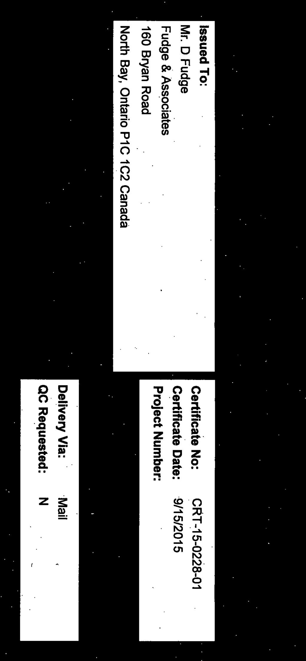
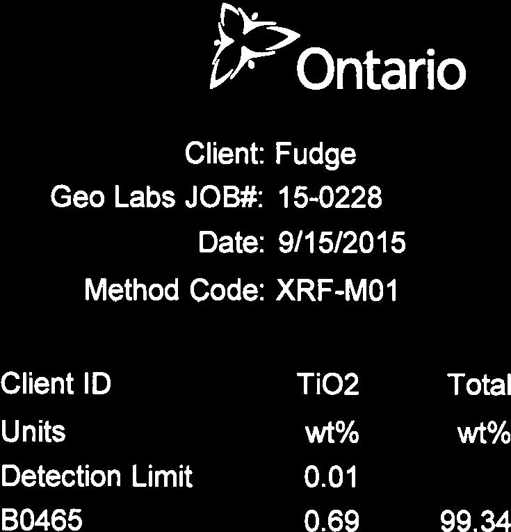
2 Report of Work G. Mote Claim S Sudbury Mining Division UTM: Zone 17, m E, m N - NAD 83 September 15, 2015 s Hand Stripping & Sampling
3 Report of Work G. Mote Claim S Contents 1.0 Introduction Location and Access Claim Status Personnel Previous Work General Geology Work Program Conclusions and Recommendations... 8 CERTIFICATION... 9 Appendix A - Assay Certificate P a g e
4 1.0 Introduction Report of Work G. Mote Claim S This report deals with the logistics and results of a hand stripping and grab sample program carried out on staked mining claim S registered 50% each to Gary M. Mote and Glen J. Mote, in Lasalle Township, Sudbury Mining Division. The field work was completed between August 24 st and September 5 th, The purpose of the program was to strip and identify bedrock to evaluate its suitability for use as decorative stone. The material was thought to be similar to stone produced from the nearby quarries operated by Callander Industries and McLarens Bay Mica in McAuslan Twp. Glen and Gary Mote of Callander, Ontario carried out the hand stripping and grab sample collection under the direction of the author who examined the property on September 5, Location and Access The Property is located in south west corner of Lasalle Township approximately 1 km east of the ONR Rail Siding at Diver in the District of Nipissing, Sudbury Mining Division. From North Bay, access is northeast on Highway 63 then north via the McConnell Lake Road for 27 km, then westerly for 18 km through the abandoned Diver Air strip to mining claim S Post # 1 of the claim is located 150 meter north of the access road at Zone 17, m E, m N (Nad 83). 3.0 Claim Status The Property consists of 1 staked mining claim totaling 2 units in the south west corner of Lasalle Township approximately 1 km east of the ONR siding at Diver. The claims are recorded as follows, held by Gary M. Mote and Glen J. Mote. The 2 claim units overlap Mining Lease also registered to G. Mote. SUDBURY - Division 70 Claim No: S Status: ACTIVE Due Date: 2015-Sep-23 Recorded: 2012-Nov-23 Work Required: $ 800 Staked: 2012-Nov-19 16:30 Total Work: $ 0 Township/Area: LA SALLE (G-1485) Total Reserve: $ 0 Lot Description:, Present Work Assignment: $ 0 Claim Units: 2 Claim Bank: $ 0 Claim Holders Recorded Holder(s) Percentage Client Number MOTE, GARY M ( %) MOTE, GLEN JOSEPH ( %) Personnel 3 P a g e
5 Report of Work G. Mote Claim S Gary and Glen Mote, Callander Ontario carried out stripping, between August 24 st and September 5 th, Don Fudge of Fudge & Associates, North Bay visited the site on September 5 th Previous Work The general area has been the subject of intermittent exploration focused on development of decorative stone since the early Most local work has focused on exploration and production from McLaren s Bay Mica and Callander Industries located 10 km to the east A limited amount of stripping, blasting and sample collection was undertaken by the leasehold in the 1970 s, however there is no record of the work in MNDM Assessment Records. 6.0 General Geology Mining Claim S is underline by biotite granitic gneiss rock and is thought to be sited within the Grenville Front Techtronic Zone near eastern edge of the Tomiko Terrane. In this part of the Grenville Province, the northern part of the Grenville Front tectonic zone consists mainly of tectonized Archean metasedimentary rocks belonging to the Red Cedar Lake gneiss. 1 1 Easton, R.M Geology and mineral potential of the eastern Tomiko terrane, Grenville Province; Ontario Geological Survey, Open File Report 5554, 117p. 4 P a g e

6 Report of Work G. Mote Claim S P a g e
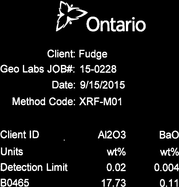
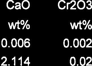
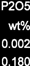
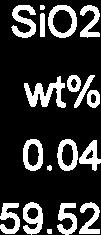
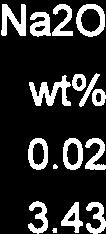
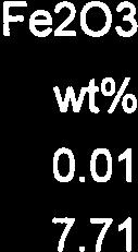
7 7.0 Work Program Report of Work G. Mote Claim S The hand stripping was carried out between August 24 and September 5th, 2015 under the field direction of D. Fudge. The location was chosen following prospecting which located biotie rich bands in gneissic granitic outcrop. Several locations were, cleaned with hand tools and a single representative sample was taken and shipped to Ministry of Northern Development and Mines Geosciences Laboratory in Sudbury for whole rock analysis. ( SAM-SPG XRF-M01) to determine if deleterious elements may be present. Where exposed the outcrop displayed irregular banding although less pronounced than that found in the McLarens Bay Quarry some 10 km east of the property. The banding imparts a variable foliation in the rock and acts as a plane of weakness for splitting the stone. The bands range from less that 1 mm up to. 5 meters. Quartz occurs as lenses and blebs with minor hematite staining. The stone is characterized by a satin black colour when exposed to sunlight or green when the biotite grades into muscovite. Quality determining properties include colour, abundance of mica, grain size, uniformity and joint spacing. 6 P a g e
8 Report of Work G. Mote Claim S P a g e

9 Report of Work G. Mote Claim S Photo 1 Stripped Outcrop Photo 2 Biotite rich feldspathic gneiss with quartz lenses 8.0 Conclusions and Recommendations Exposed rock show significantly less parallel foliation than rock from McLarens Bay Mica in McAuslan Township, and may be less suitable for splitting. Dependent on jointing and fracture patterns the more massive rock may be suitable for quarrying and production of dimension stone blocks and crushed products An abundance of black and green mica both which sparkle when exposed to sunlight should make it an attractive dimension or landscape product. Major element analysis suggest that deleterious leachable mineral is absent from the sample. As a next step toward commercial production, a kg sample should be acquired for physical property testing. Recovery of residual mica should be considered as a potential byproduct. 8 P a g e
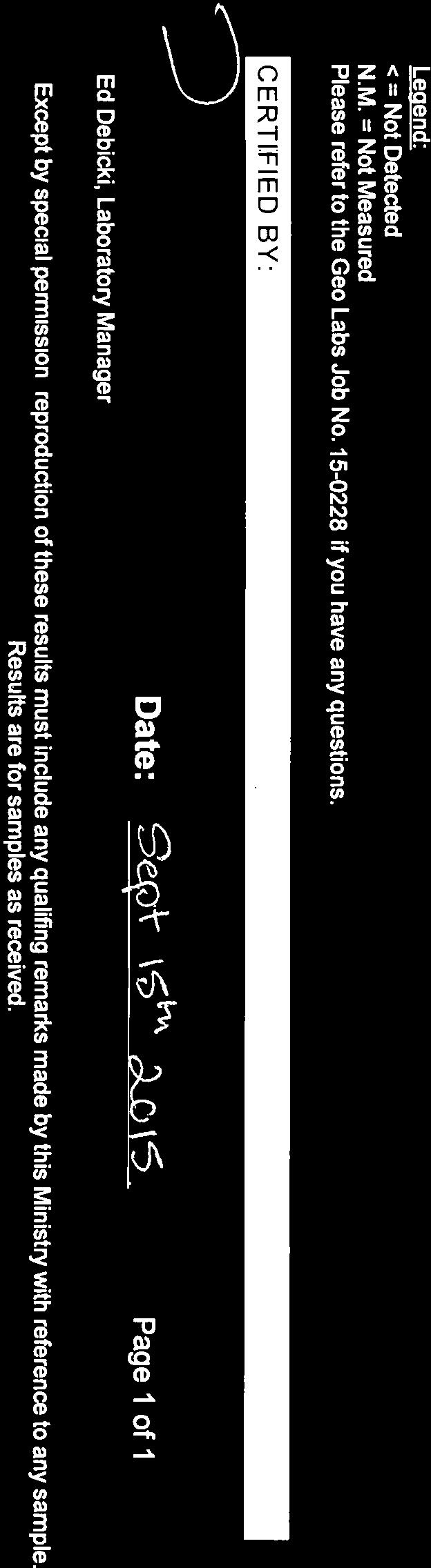
10 Report of Work G. Mote Claim S CERTIFICATION I, Donald Thomas Fudge of North Bay, Ontario hereby certify that: 1. I hold a three-year Business Administration Diploma from Cambrian College of Applied Arts, North Bay, Ontario obtained in 1969, 2. That I am a Prospector and have been practicing my profession since 1975 in Ontario, Quebec, Newfoundland, Manitoba, Alberta, British Columbia, The United States of America, Jamaica, Guyana, Ukraine and China. 3. That I have been employed directly by Teck Corporation, Metallgessellshaft Canada Limited, and the Ontario Ministry of Natural Resources and have been self-employed with Fudge & Associates since I have based my conclusions and recommendations contained in this report on knowledge of the area, my previous experience and on the results of the fieldwork conducted on the property. 5. That I hold no interest in the property either directly or indirectly. Dated this 15th day of September 2015 At North Bay Ontario Don T. Fudge 9 P a g e
11 Appendix A - Assay Certificate
12 Report of Work G. Mote Claim S P a g e

13


14
15
We are committed to providing accessible customer service. If you need accessible formats or communications supports, please contact us.
 We are committed to providing accessible customer service. If you need accessible formats or communications supports, please contact us. Nous tenons à améliorer l accessibilité des services à la clientèle.
Report. Mining Claim SO Butt Township. District of Nipissing. Southern Ontario Mining District. Richard Keevil ~ Geologist. August 29,2006.
 Report On Mining Claim SO 1077365 Butt Township District of Nipissing Southern Ontario Mining District ~ "'_I ""'..1 D I..:"'.U&O... ~u ~]. Richard Keevil ~ Geologist August 29,2006. Richard R. Keevil,
We are committed to providing accessible customer service. If you need accessible formats or communications supports, please contact us.
 We are committed to providing accessible customer service. If you need accessible formats or communications supports, please contact us. Nous tenons à améliorer l accessibilité des services à la clientèle.
2013 GEOLOGICAL ASSESSMENT REPORT SHERIDAN HILL PROPERTY
 2013 GEOLOGICAL ASSESSMENT REPORT ON THE SHERIDAN HILL PROPERTY NEW WESTMINSTER MINING DIVISION BRITISH COLUMBIA NTS 092G07 49 16 31 NORTH LATITUDE, 122 39 48 WEST LONGITUDE PREPARED FOR Sheridan Hill
SECOND and THIRD YEAR ASSESSMENT REPORT PROSPECTING LICENCE M, ROCK CUT PROPERTY, NTS 1N/12, NEWFOUNDLAND. ROY FRENCH (licence holder )
") SECOND and THIRD YEAR ASSESSMENT REPORT Of PROSPECTING On LICENCE 013704M, ROCK CUT PROPERTY, NTS 1N/12, NEWFOUNDLAND. By ROY FRENCH (licence holder ) Work Conducted: Sept. 17, 2008 Nov. 03, 2009 Total
SECOND and THIRD YEAR ASSESSMENT REPORT Of PROSPECTING On LICENCE 013704M, ROCK CUT PROPERTY, NTS 1N/12, NEWFOUNDLAND. By ROY FRENCH (licence holder ) Work Conducted: Sept. 17, 2008 Nov. 03, 2009 Total
We are committed to providing accessible customer service. If you need accessible formats or communications supports, please contact us.
 We are committed to providing accessible customer service. If you need accessible formats or communications supports, please contact us. Nous tenons à améliorer l accessibilité des services à la clientèle.
We are committed to providing accessible customer service. If you need accessible formats or communications supports, please contact us.
 We are committed to providing accessible customer service f you need accessible formats or communications supports please contact us Nous tenons à améliorer l accessibilité des services à la clientèle
We are committed to providing accessible customer service. If you need accessible formats or communications supports, please contact us.
 We are committed to providing accessible customer service. If you need accessible formats or communications supports, please contact us. Nous tenons à améliorer l accessibilité des services à la clientèle.
REPORT ON DIAMOND DRILLING SUBSTITUTION EAST PROPERTY CLAIMS AND HEBERT TOWNSHIP ONTARIO, CANADA
 REPORT ON DIAMOND DRILLING SUBSTITUTION EAST PROPERTY CLAIMS 1248920 AND 1248921 HEBERT TOWNSHIP ONTARIO, CANADA Adroit Resources Inc. Suite #610-1111 Melville Street Vancouver, British Columbia, Canada
WORK REPORT. on the ALEXO PROPERTY DUNDONALD TOWNSHIP PORCUPINE MINING DIVISION. for LIBERTY MINES INC.
 GEOSCIE CE AS r::;ss lent OFFICE WORK REPORT on the ALEXO PROPERTY DUNDONALD TOWNSHIP PORCUPINE MINING DIVISION for LIBERTY MINES INC. 2. 340 51 Submitted by: Steve Anderson VISION EXPLORATION 2041663
We are committed to providing accessible customer service. If you need accessible formats or communications supports, please contact us.
 We are committed to providing accessible customer service. If you need accessible formats or communications supports, please contact us. Nous tenons à améliorer l accessibilité des services à la clientèle.
BLURTON CREEK NICKEL PROPERTY. (Minfile # 082LNW-039)
") 5489153 BLURTON CREEK NICKEL PROPERTY (Minfile # 082LNW-039) Mara Lake Area / Salmon Arm B.C NTS - 82L-11 (UTM 83/Z10, 357690E, 5614220N) Prepared by: Jim Cuttle, B.Sc., P.Geo. 86 Cloudburst Road Whistler,
5489153 BLURTON CREEK NICKEL PROPERTY (Minfile # 082LNW-039) Mara Lake Area / Salmon Arm B.C NTS - 82L-11 (UTM 83/Z10, 357690E, 5614220N) Prepared by: Jim Cuttle, B.Sc., P.Geo. 86 Cloudburst Road Whistler,
Reconnaissance. Of the. Denis mineral claims. Situated at Kilometer 844 of the Alaska Highway. Liard Mining Division. Northeastern British Columbia
 Reconnaissance Of the Denis mineral claims Situated at Kilometer 844 of the Alaska Highway Liard Mining Division Northeastern British Columbia N.T.S. 94M.075 Latitude 59 42 25 Longitude 127 13 12 Field
Montgomery Bedrock Geology 21d-Gowganda Formation: conglomerate, sandstone, siltstone, argillite
 Work Report 2014 Trenching Montgomery Township G-3303 Claim #4259384,4245818 Sault Ste. Marie Mining Division Michael & Yvon Gagne Montgomery Copper Property 1 P a g e 2 P a g e Montgomery Bedrock Geology
We are committed to providing accessible customer service. If you need accessible formats or communications supports, please contact us.
 We are committed to providing accessible customer service. If you need accessible formats or communications supports, please contact us. Nous tenons à améliorer l accessibilité des services à la clientèle.
ASSESSMENT REPORT ON THE PEAVINE PROJECT. DGW & Associates # Alberni Street, Vancouver, British Columbia, V6E 4V2
 ASSESSMENT REPORT ON THE PEAVINE PROJECT KAMLOOPS MINING DIVISION BRITISH COLUMBIA NTS 082M 12 Latitude 51 36' 19.0"North -- Longitude --119 47' 27.0"West UTM Zone 11, NAD 83 5720827N 306744E Prepared
Wavy Lake Silica Property. Silica Assays - EDEN TOWNSHIP -
 Wavy Lake Silica Property Silica Assays - EDEN TOWNSHIP - Prepared by: Robert G. Komarechka P.Geo. Dec. 8, 2011 1 TABLE OF CONTENTS INTRODUCTION...3 LOCATION and ACCESS...3 page PROPERTY TENURE...3 PREVIOUS
Summary of Rover Metals Geologic Mapping Program at the Up Town Gold Project, Northwest Territories
 October 13, 2017 Summary of Rover Metals Geologic Mapping Program at the Up Town Gold Project, Northwest Territories Vancouver, British Columbia, Canada - Rover Metals Corp., Rover, is pleased to provide
Simplified exploration work report
 Simplified exploration work report Work Report of exploration and examination of outcrops of rock and boulders Report on stripping and excavating work of $ 5 000 or less.(section 81 of regulation) Report
We are committed to providing accessible customer service. If you need accessible formats or communications supports, please contact us.
 We are committed to providing accessible customer service. If you need accessible formats or communications supports, please contact us. Nous tenons à améliorer l accessibilité des services à la clientèle.
NTS 082F03SW N W U E N
 Prospecting Report JOCELYN CLAIM NTS 082F03SW N49 09 51 W 117 14 04 11U 482906E 5445737N NELSON MINING DIVISION Martin Ross PO Box 323 Salmo BC V0G 1Z0 Jan 31, 2012 PROSPECTING REPORT JOCELYN MINERAL CLAIM
FIRST YEAR ASSESSMENT REPORT PROSPECTING LICENCE 16512M MARYSTOWN AREA, BURIN PENINSULA NTS 1M/3
 FIRST YEAR ASSESSMENT REPORT OF PROSPECTING ON LICENCE 16512M MARYSTOWN AREA, BURIN PENINSULA NTS 1M/3 BY NATHANIEL NOEL MSc. FOR E. MICHELE NOEL MINERAL LICENCES: 16512 M WORK CONDUCTED: MID-SEPTEMBER
PROSPECTING Survey Over the AULD PROPERTY Auld Township, Ontario
 PO Box 219, 14579 Government Road, Larder Lake, Ontario, P0K 1L0, Canada Phone (705) 643-2345 Fax (705) 643-2191 www.cxsltd.com PROSPECTING Survey Over the AULD PROPERTY C Jason Ploeger, B.Sc, P.Geo August
MRD273-REV METADATA. Acronyms are Used to Identify the Data Set or Information Holding: MRD273-REV
 MRD273-REV METADATA GENERAL INFORMATION Official Name of the Data Set or Information Holding: Ontario Precambrian Bedrock Magnetic Susceptibility Geodatabase for 2001 to 2012 Acronyms are Used to Identify
DiaMine Exploration Inc. Pickle Lake Option Property
 DiaMine Exploration Inc. Pickle Lake Option Property Rock Sampling Program and Field Observations Claims 4249174, 4249175, 4249176 and 4249177, Kapkichi Lake Area (G-2081) And Claims 4249178, 4249179 and
We are committed to providing accessible customer service. If you need accessible formats or communications supports, please contact us.
 We are committed to providing accessible customer service. If you need accessible formats or communications supports, please contact us. Nous tenons à améliorer l accessibilité des services à la clientèle.
1 CLAIMS GEOPHYSICAL REPORT ON BOYAL SITUATE NORTHEAST OF TILLICUM MOUNTAIN GOLD AREA BURTON - NAKUSP SIQCAEJ MINING DIVISION
 GEOPHYSICAL REPORT ON BOYAL 1 CLAIMS SITUATE NORTHEAST OF TILLICUM MOUNTAIN GOLD AREA BURTON - NAKUSP SIQCAEJ MINING DIVISION CONSULTING GEOLOGIST AUGUST 1983 VANCOUVER B *C INDEX INTRODUCTION ooa,.eoaaa.aaaoaaooaoa~ao~o
1 FILMED 1. FILE NO:!..rsrru -* -. GRAND TWO CLAIM
 FILE NO:!..rsrru -* -. GRAND TWO CLAIM REPORT ON 1993 ASSESSMENT WORK GRAND TWO CLAIM REC. NO. 301849 NELSON MINING DIVISION NTS MAP SHEET 82F6/W 49 25'51" NORTH 117 18'08" WEST 1 FILMED 1 AUTHOR: R. Jordan,
We are committed to providing accessible customer service. If you need accessible formats or communications supports, please contact us.
 We are committed to providing accessible customer service. If you need accessible formats or communications supports, please contact us. Nous tenons à améliorer l accessibilité des services à la clientèle.
PROSPECTING REPORT THE WALLACE CLAIM OMENICA MINING DIVISION. 54" x6" 3.d d. for. Reako Exlorat ions Ltd. Wallace Rev. C.G.
 PROSPECTING REPORT ON THE WALLACE CLAIM OMENICA MINING DIVISION 54"44 14 1x6" 3.d d by David A. Howard P.Eng. for Reako Exlorat ions Ltd. Claim Locat ion Wallace Rev. C.G. #1560 Dome Mountain Area 9 3
We are committed to providing accessible customer service. If you need accessible formats or communications supports, please contact us.
 We are committed to providing accessible customer service. If you need accessible formats or communications supports, please contact us. Nous tenons à améliorer l accessibilité des services à la clientèle.
BALFOUR MINING LTD. (N.P.L.) HAM GROUP 92-P-6, CLINTON M. D.8 B. C. Lat 51 17'N, GEOCHEMICAL REPORT. V. CUKOR, P. Eng.
 HAM GROUP 92-P-6, CLINTON M. D.8 B. C. Lat 51 17'N, GEOCHEMICAL REPORT. V. CUKOR, P. Eng.") 34q '7 BALFOUR MINING LTD. (N.P.L.) HAM GROUP 92-P-6, CLINTON M. D.8 B. C. Lat 51 17'N, Long 12lo14'W GEOCHEMICAL REPORT, V. CUKOR, P. Eng. January 31, 1972 TABLE OF CONTENTS 1. INTRODUCTION 2. PROPERTY,
34q '7 BALFOUR MINING LTD. (N.P.L.) HAM GROUP 92-P-6, CLINTON M. D.8 B. C. Lat 51 17'N, Long 12lo14'W GEOCHEMICAL REPORT, V. CUKOR, P. Eng. January 31, 1972 TABLE OF CONTENTS 1. INTRODUCTION 2. PROPERTY,
Geological Mapping and Mineralization on the eastern part of the Mumford Claim Cardiff Township, Ontario
 Geological Mapping and Mineralization on the eastern part of the Mumford Claim Cardiff Township, Ontario SO 1500016 (Lots 9-11, Concession 22 and Lot 11, Concession 21)), By Bradley S Wilson Kingston,
MRD 281. Official Name of the Data Set or Information Holding: Northeastern Ontario Rhyolite Database
 MRD 281 GENERAL INFORMATION Official Name of the Data Set or Information Holding: Northeastern Ontario Rhyolite Database Acronyms are Used to Identify the Data Set or Information Holding: MRD281 Describe
for the Greenwood Mining Division, B.C. NTS 82E/7W Latitude 49' 27' W, Longitude 118' 5 Prepared by a= D. Dylan Watt, B.Sc.
 t. b LOGnO: 37~ -08 m. ACTIO#: for the AMP AMP 2 AMP 3 t AMP 4 CLAIMS Greenwood Mining Division, B.C. NTS 82E/7W Latitude 49' 27' W, Longitude 8' 5 %E c,w zc *& a w Prepared by a= -4c. D. Dylan Watt, B.Sc.
RECONNAISSANCE GEOCHEMICAL SURVEY
 RECONNAISSANCE GEOCHEMICAL SURVEY LEGAL, RITA, LOUISE FR. (CHAPLEAU GROUP) REVERTED CROWN GRANTS CHAPLEAU CREEK AREAJ, SLOC& MINING DIVISION 82 F/11W Lat: 49'44" Long: 117"22'W MINERAL RESOURCES BRANCH
32?un North of Hope, B.C.,
 Geological Reconnaissance Assessment Report on portions of the Gilt Creek Group (Mike, C.G., Julie, and Gilt Mineral Claims) Situated 32?un North of Hope, B.C., New Westminster Mining Division N 'P 97H/11W
PHYSICAL WORK REPORT. the BAY CLAIMS. Omineca Mining Division Smithers, British Columbia N.T.S. 93E 13E/W
 PHYSICAL WORK REPORT the BAY CLAIMS Omineca Mining Division Smithers, British Columbia a N.T.S. 93E 13E/W LATITUDE: 53 57 00 N I LONGITUDE: 127 45 OO W for Home Ventures Ltd. 1201-675 West Hastings Street
DRILLING REPORT ON THE HIGHLAND VALLEY, KAMLOOPS MINING DIVISION, OWNED BY GAZA MINES LTD., NEW JERICHO DEVELOPMENT AND TECK CORPORATION
 DRILLING REPORT ON THE GAZA 1 AND JERICHO 1 AND 2 MINERAL CLAIMS / (RECORD NUMBERS 159, 492 AND 161) HIGHLAND VALLEY, KAMLOOPS MINING DIVISION, LATITUDE 50' 26' N; LONGITUDE 120' 55' W; NTS 92-I/7W OWNED
AGGREGATE RESOURCES OF ONTARIO (ARO) METADATA
 METADATA") AGGREGATE RESOURCES OF ONTARIO (ARO) METADATA GENERAL INFORMATION Official Name of the Data Set or Information Holding: Aggregate Resources of Ontario Acronyms are Used to Identify the Data Set or Information
AGGREGATE RESOURCES OF ONTARIO (ARO) METADATA GENERAL INFORMATION Official Name of the Data Set or Information Holding: Aggregate Resources of Ontario Acronyms are Used to Identify the Data Set or Information
TIGER GOLD EXPLORATION CORPORATION. Prospecting Over the HARKER HERITAGE PROPERTY AREA 10. Harker Township, Ontario
 PO Box 219, 14579 Government Road, Larder Lake, Ontario, P0K 1L0, Canada Phone (705) 643-2345 Fax (705) 643-2191 www.cxsltd.com TIGER GOLD EXPLORATION CORPORATION Prospecting Over the HARKER HERITAGE PROPERTY
Geneva Lake Mine Property
 2 "-,." j, i.. \' i Fli FR l- ' 2 "- ''. -" ^tji. o -^' " - - - S? l GEOSCIENCE ASSESSMENT Reconnaissance" Prospecting and Geological Surveys on the j Geneva Lake Mine Property Hess TOWNSHIP Zn-Pb-Cu-Ag
2010 ASSESSMENT REPORT ON PROSPECTING AND ROCK SAMPLING MICHIKAMATS PROPERTY
 2010 ASSESSMENT REPORT ON PROSPECTING AND ROCK SAMPLING MICHIKAMATS PROPERTY Licences no 017501M, 017505M, 017502M, 017503M, 017504M, 017507M, 017508M, 017509M, 017511M, 017512M, 017516M, 017500M and 017529M
XRAL X-RAY Bharti Engineering Associates Inc Lasalle Blvd. P O Box 2336 Sudbury (M P3A4S8. DATE SUBMITTED 9-Aug-89
 XRAL X-RAY 1885 LESLIE S TEL: (416)445 41113SE9429 2.12731 ULSTER 010 C ERT X F X O A.T E TO: BHARTI ENGINEERING ASSOCIATES INC. ATTN: HAROLD J. TRACANELLI 1009 LASALLE BLVD P.O. BOX 2336 SUDBURY, ONTARIO
CJP EXPLORATION INC.
 PO Box 219 14579 Government Road Larder Lake, Ontario P0K 1L0, Canada Phone (705) 643-1122 Fax (705) 643-2191 CJP EXPLORATION INC. Spectrometer Survey Over the SHEBA PROPERTY Nouvel Township, Ontario TABLE
The Kennady North Project Investor Presentation Q2 2017
 The Kennady North Project Investor Presentation Q2 2017 Forward Looking Statement This presentation may contain forward-looking statements. These forward-looking statements are made as of the date of the
SKEAD HOLDINGS LTD. Prospecting Over the. PUSEY LAKE PROPERTY Cardiff Township, Ontario
 PO Box 219, 14579 Government Road, Larder Lake, Ontario, P0K 1L0, Canada Phone (705) 643-2345 Fax (705) 643-2191 www.cxsltd.com SKEAD HOLDINGS LTD. Prospecting Over the PUSEY LAKE PROPERTY Cardiff Township,
Within. Mineral Claim
 31E12SE2001 2.19268 RYERSON 010 2.19-68 January 15,1999 ASSESSMENT REPORT ON A GEOLOGICAL MAPPING PROJECT Within Mineral Claim 1077246 Ryerson Township, Southern Ontario TABLE OF CONTENTS 1. Summary And
We are committed to providing accessible customer service. If you need accessible formats or communications supports, please contact us.
 We are committed to providing accessible customer service. If you need accessible formats or communications supports, please contact us. Nous tenons à améliorer l accessibilité des services à la clientèle.
Assessment Work Report (Stripping & Mapping) HavikLake Granite Dimension Stone Deposit (Redditt Auburn) Kilgore Lake Area Kenora Mining Division
 HavikLake Granite Dimension Stone Deposit (Redditt Auburn) Kilgore Lake Area Kenora Mining Division") Assessment Work Report (Stripping & Mapping) HavikLake Granite Dimension Stone Deposit (Redditt Auburn) Kilgore Lake Area Kenora Mining Division Claim K-3007960 for Redditt Stones Inc. -' 2 3523 1 Prepared
Assessment Work Report (Stripping & Mapping) HavikLake Granite Dimension Stone Deposit (Redditt Auburn) Kilgore Lake Area Kenora Mining Division Claim K-3007960 for Redditt Stones Inc. -' 2 3523 1 Prepared
Compilation Report Hawke Hill South. Licence No M NTS 01N/06. Newfoundland and Labrador. Submitted by Gordon E. Cooper and Kevin P.
 Compilation Report 2010 Hawke Hill South Licence No. 017282M NTS 01N/06 Newfoundland and Labrador Submitted by Gordon E. Cooper and Kevin P. Ryan For Kevin P. Ryan (Licence holder) January, 2011 Work Year:
SUMMARY REPORT. ESSAR STEEL ALGOMA INC. 105 West Street, Sault Ste. Marie, Ontario, Canada P6A 7B4
 SUMMARY REPORT IRON LAKE PROPERTY Keating and Keating Additional Townships, Ontario, Canada ESSAR STEEL ALGOMA INC. 105 West Street, Sault Ste. Marie, Ontario, Canada P6A 7B4 Date: March 18, 2013 Prepared
4. Geological maps published by the Ontario Department of Mines.
 52J08NWei45 S2J08NWa6B1 SMYE 010 AMALGAMATED RARE EARTH MINES LTD. *, SAVANT LAKE PROSPECT x ONTARIO INTRODUCTION t This Is a report on a group of 28 claims control led by Amalgamated Rare Earth Mines
We are committed to providing accessible customer service. If you need accessible formats or communications supports, please contact us.
 We are committed to providing accessible customer service. If you need accessible formats or communications supports, please contact us. Nous tenons à améliorer l accessibilité des services à la clientèle.
Spent several times the time exploring off claim as opposed to on claim with expected intent of registering more claims.
 .. 1 Report of daily work done on claim 504253731 Allen Currie Aug.24, 2009 Register claim RECEVED AUG 1 2 2011 GEOSCENCE ASSESSMENT OFFCE Sept. 15, 23, Oct. 19, 20, Nov. 15,20 2009; Exploring ridge of
MRD 229-Revised METADATA
 GENERAL INFORMATION MRD 229-Revised METADATA Official Name of the Data Set or Information Holding: Till Compositional Database: Investigation of the Overburden Signature of the Caribou Lake Greenstone
First Year Assessment Report: Report on Prospecting, Rock and Soil Sampling Carried Out From September/2012 to December/2012.
 First Year Assessment Report: Report on Prospecting, Rock and Soil Sampling Carried Out From September/2012 to December/2012 on the Clarkes Pond Property Licence 020334M Northwest Gander River,Central
compietea since tnat date, and wnicn comprisea btage I ot tne recommended
 compietea since tnat date, and wnicn comprisea btage I ot tne recommended four-stage program. GEOLOGY & MINERALIZATION The property situate6 on the southeast slope of Nickel Plate Mtn., and within the
TECHNICAL REPORT ON THE BLACK CREEK PROPERTY FOR CARRIE ARRAN RESOURCES BLACK TOWNSHIP LARDER LAKE MINING DIVISION ONTARIO
 TECHNICAL REPORT ON THE BLACK CREEK PROPERTY FOR CARRIE ARRAN RESOURCES BLACK TOWNSHIP LARDER LAKE MINING DIVISION ONTARIO B.J. McKay, 8 February 2011 Keewatin, Ontario TECHNICAL REPORT BJML 2011 Table
SELF POTENTIAL SURVEY OVER THE JAY GROUP, INVERMERE AREA GOLDEN MINING DIVISION, BFUTISH COLUMBIA NTS 82W8W7 82W9W LATLONG 50 30' ' FOR
 - GEOLOGICAL SURVEY BRANCH ASSESSMENT REPORTS -- -- DATE RECEI?/::D 06T 10 1996 - SELF POTENTIAL SURVEY OVER THE JAY GROUP, INVERMERE AREA GOLDEN MINING DIVISION, BFUTISH COLUMBIA NTS 82W8W7 82W9W LATLONG
Rubicon Minerals Corporation. Physical Work Submission Report June, RED LAKE PROPERTY MECHANICAL STRIPPING South Pipestone Bay
 Rubicon Minerals Corporation Physical Work Submission Report June, 2001 RED LAKE PROPERTY MECHANICAL STRIPPING South Pipestone Bay Ball Township Red Lake Mining Division NTS 52/N4 2.216 A /^ r--^'^-, t'n
GEOLOGIC ASSESSMENT / QUARRY PLAN REVIEW BLACK GOLD GRANITE QUARRY DEVELOPMENT
 GEOLOGIC ASSESSMENT / QUARRY PLAN REVIEW BLACK GOLD GRANITE QUARRY DEVELOPMENT GARIBALDI RESOURCES CORP. BLACK GOLD GRANITE CLAIMS GREENWOOD MINING DIVISION GRAND FORKS, B.C., CANADA NTS 82 E/7 E UTM (Zone
Mishi Lake Gold Property Mishibishu Lake Area, Wawa
 Mishi Lake Gold Property Mishibishu Lake Area, Wawa Location, Accessibility, Infrastructure and Local Resources The property is located 40 km west of Wawa, Ontario, in the Mishibishu Lake Area, Sault Ste.
REPORT ON GEOLOGICAL MAPPING OF CLAIM SHAW TOWNSHIP PORCUPINE MINING DIVISION) NORTHEASTERN ONTARIO FOR LAURION GOLD INCORPORATED
 NORTHEASTERN ONTARIO FOR LAURION GOLD INCORPORATED") REPORT ON GEOLOGICAL MAPPING OF CLAIM 1180899 SHAW TOWNSHIP PORCUPINE MINING DIVISION) NORTHEASTERN ONTARIO * O Q Q fi FOR LAURION GOLD INCORPORATED Schumacher, ON November 29th, 2004 Leslie A. Tihor Tihor
REPORT ON GEOLOGICAL MAPPING OF CLAIM 1180899 SHAW TOWNSHIP PORCUPINE MINING DIVISION) NORTHEASTERN ONTARIO * O Q Q fi FOR LAURION GOLD INCORPORATED Schumacher, ON November 29th, 2004 Leslie A. Tihor Tihor
NOA ASSESSMENT HARRIS QUARRY MENDOCINO COUNTY, CALIFORNIA TABLE OF CONTENTS
 NOA ASSESSMENT HARRIS QUARRY MENDOCINO COUNTY, CALIFORNIA TABLE OF CONTENTS Introduction... 1 Scope of Services... 1 Project Location and Description... 1 Geologic Setting... 1 Regional Geology... 1 Site
RECEIVED MINING LANDS SECTION. a.9535 MCTAVISH. E.A. JENNINGS, H.D.Se. Thunder Bay, Ontario September GEOLOGY OF THE THUNDER BAY AMETHYST MINE
 a.9535 MCTAVISH 010 GEOLOGY OF THE THUNDER BAY AMETHYST MINE AND PRECIOUS PURPLE GEMSTOHES CLAIMS E.A. JENNINGS, H.D.Se. Thunder Bay, Ontario September 30 1985 RECEIVED MOV l o 1986 MINING LANDS SECTION
MRD 207 METADATA DETAIL PAGE
 MRD 207 METADATA DETAIL PAGE The following represents the Basic description of an information holding. To obtain more information about this holding, see the section named Contacts. GENERAL INFORMATION
RECEIVED. Report. Butt Township. District Of Nipissing. Southern Ontario Mining Division. Submitted By: Don K.D. Baxter, P.Eng.
 Report On Mining Claims 1077365, 1077366, 1077367, 1077370 Butt Township District Of Nipissing Southern Ontario Mining Division Submitted By: Don K.D. Baxter, P.Eng. Huntsville, Ontario AUGUST 27, 2001
for the Greenwood Mining Division, B.C. NTS 82E/7W 29' W, Longitude 118' 53' N Prepared by D. Dylan Watt, B.Sc.
 for the FltE NO: u VOLT 1, VOLT 2, VOLT 3, & VOLT 4 CLAIMS Greenwood Mining Division, B.C. NTS 82E/7W Latitude 49' 29' W, Longitude 118' 53' N Prepared by D. Dylan Watt, B.Sc. #309-1996 Trutch Street Vancouver,
We are committed to providing accessible customer service. If you need accessible formats or communications supports, please contact us.
 We are committed to providing accessible customer service. If you need accessible formats or communications supports, please contact us. Nous tenons à améliorer l accessibilité des services à la clientèle.
WORK REPORT on the ALEXO PROPERTY DUNDONALD TOWNSHIP PORCUPINE MINING DIVISION for LIBERTY MINERAL EXPLORATION
 WORK REPORT on the ALEXO PROPERTY DUNDONALD TOWNSHIP PORCUPINE MINING DIVISION for LIBERTY MINERAL EXPLORATION Submitted by: Steve Anderson VISION EXPLORATION 170 Second Ave Timmins, Ontario P4N-IGI Phone:
Report on Exploratory Drilling. Prospecting Claim Nos and
 Report on Exploratory Drilling Prospecting Claim Nos. 4212342 and 4212343 Glamorgan Township, Lot 34, Concession IV: Southern Ontario Mining Division Exploratory Drilling Program Site Work: November 11-17,2008
TIGER GOLD EXPLORATION CORPORATION. Prospecting Over the HARKER HERITAGE PROPERTY AREA 1. Clifford Township, Ontario
 PO Box 219, 14579 Government Road, Larder Lake, Ontario, P0K 1L0, Canada Phone (705) 643-2345 Fax (705) 643-2191 www.cxsltd.com TIGER GOLD EXPLORATION CORPORATION Prospecting Over the HARKER HERITAGE PROPERTY
GEOLOGICAL MAPPING REPORT ON THE ASH MINERAL CLAIM OSOYOOS MINING DIVISION ASHNOLA RIVER MAP SHEET NTS M092,H019 MCBRIDE CREEK AREA, ASHNOLA RIVER,
 GEOLOGICAL MAPPING REPORT ON THE ASH MINERAL CLAIM OSOYOOS MINING DIVISION ASHNOLA RIVER MAP SHEET NTS M092,H019 LATITUDE 49 o O6, LONGITUDE 120 o 22 MCBRIDE CREEK AREA, ASHNOLA RIVER, KEREMEOS, B.C. CANADA
PROSPECTING REPORT. Broken Hill Property. EVENT # TENURE # Tenure Name: Broken Hill. New Westminster Mining Division Map 092H
 2009-2010 PROSPECTING REPORT Broken Hill Property EVENT # 4514071 TENURE # 600988 Tenure Name: Broken Hill New Westminster Mining Division Map 092H Central Coordinate Reference 121 24 26.2 W Longitude
Hope Brook gold mine, NL - Copper, then switched to gold
 Chapter 12 : Mining in NL Defined as the extraction of valuable minerals from Earth from an ore body, vein, or seam. A mineral is any chemical substance arranged in some crystalline structure. - must have
NELSON GRANITE LIMITED. Test Quarrying, Sample Block Removal. Sawing and Polishing Tests. Mining Claim K-l Kilgour Lake Area NTS: 52K 4SW
 l 52K04SW2005 2.20708 KILGOUR LAKE 010 2.20708 NELSON GRANITE LIMITED Test Quarrying, Sample Block Removal Sawing and Polishing Tests Mining Claim K-l 149856 Kilgour Lake Area NTS: 52K 4SW Kenora Mining
GEOPHYSICAL DATA SET (GDS) 1084B METADATA
 1084B METADATA") GEOPHYSICAL DATA SET (GDS) 1084B METADATA GENERAL INFORMATION Official Name of the Data Set or Information Holding: Ontario Airborne Geophysical Surveys, Magnetic Gradiometer and Gamma-Ray Spectrometric
GEOPHYSICAL DATA SET (GDS) 1084B METADATA GENERAL INFORMATION Official Name of the Data Set or Information Holding: Ontario Airborne Geophysical Surveys, Magnetic Gradiometer and Gamma-Ray Spectrometric
LUCKY BEN MINE PROJECT SEPTEMBER 2018 UPDATE
 LUCKY BEN MINE PROJECT SEPTEMBER 2018 UPDATE During the first week of July 2018 work was completed by our Geologist, Richard Morris, and support personnel to stake the Lucky Ben vein structure at surface
Report. On a 3D Magnetic Inversion. For. Cadillac Ventures Ltd. And. Newcastle Minerals Ltd. Pickle Lake Project. Ontario, Canada
 Report On a 3D Magnetic Inversion For Cadillac Ventures Ltd And Newcastle Minerals Ltd. Pickle Lake Project Ontario, Canada SCOTT HOGG & ASSOCIATES LTD October 2010 TABLE OF CONTENTS 1 INTRODUCTION...
Marshall Shore Town Park, Liberty, Maine
 Maine Geologic Facts and Localities August, 2005 Marshall Shore Town Park, Liberty, Maine 44 22 33.04 N, 69 21 9.19 W Text by Henry N. Berry IV, Department of Agriculture, Conservation & Forestry 1 Introduction
Witwatersrand-type Gold
 Pardo The Pardo JV Project, Joint Venture Ontario Witwatersrand-type Gold March 2015 TSX.V: EDG Corporate Disclosure The information contained herein, while obtained from sources which we believe are reliable,
Prospecting Report 'S Office i DB Property, B.C. -J Negro Creek Nelson Mining District NTS 82F.050. Operator: Kootenay Gold Inc.
 . '.' I"' i9 12 Prospecting Report 'S Office i DB Property, B.C. -J Negro Creek Nelson Mining District NTS 82F.050 Operator: Kootenay Gold Inc. Owner: Darlene Lavoie Work Performed Summer of 2007 Report
Lat. 52' 43' N Long ' W
 &A exploration ltd MINING ENGINEERING GEOLOGY- GEOPHYSICS 4570 HOSKINS ROAD, NORTH VANCOUVER, 6. C. TELEPHONE (804) 985,7921 V7K 2R1 GEOLOGICAL AND GEOCHEMICAL REPORT on the BLUE CLAIMS Cariboo Mining
First Year assessment Report on Prospecting and Rock sampling, King George property, License M NTS 12A/05 Newfoundland and Labrador.
 First Year assessment Report on Prospecting and Rock sampling, King George property, License 016679M NTS 12A/05 Newfoundland and Labrador. Submitted by Shawn Rose For Shawn Rose January 2011 Work year
Grassroots Exploration for Gold in Labrador
 Grassroots Exploration for Gold in Labrador Roger Moss, Nikos Explorations Ltd., Shawn Ryan, RyanWood Exploration, John Clarke, GroundTruth Exploration. Mineral Resources Review November 1 st -4 th 2017
Total Magnetic Field and VLF Surveys on the Swayze Property. Claim Swayze Township. Porcupine Mining Division
 1 January, 016 NTS: 041 O 15 Total Magnetic Field and VLF Surveys on the Swayze Property Claim 475471 Swayze Township Porcupine Mining Division 380850E, 599450N UTM Z17N NAD83 Report Prepared for: 540