Assessing, Monitoring, and Defending Coral Reefs with GIS
|
|
|
- Jonas Harrell
- 5 years ago
- Views:
Transcription

1 Assessing, Monitoring, and Defending Coral Reefs with GIS Dr. Rich Snow and Dr. Mary Snow Applied Aviation Sciences Embry-Riddle Aeronautical University Daytona Beach, Florida

2 It is estimated that 60% of Earth s coral reefs are at risk and that bleaching already has damaged 90% of living reefs. Regionally, the occurrence of coral bleaching will be highest in the Caribbean over the course of the next years. Brain coral and sea fan

3 Efficient monitoring requires the assessment of various coastal data baselines and the evaluation of subsequent alterations in spatial patterns. Relevant aspects include changes in coastal land use, wetlands, and shoreline configuration. A shallow water reef scene in Florida

4 The objective of this research is to demonstrate that GIS is an efficient instrument for conducting surveys and inventories of coral reefs in order to assess those ecosystems at higher risk and develop appropriate mitigation strategies. Flower coral


5 Louis Agassiz conducted his first studies of coral reefs in 1851 when he was commissioned by the Coast Survey to study the Florida Reefs as related to navigation of the Florida Straits

6 Today, coral reefs are studied as indicators of global change and as highly endangered ecosystems that suffer from bleaching episodes related to warming of the global ocean, pollution from chemicals and sediment, and destructive fishing practices. Barrel sponges

7 Coral reefs are in danger of destruction due to over exploitation, degradation of habitat and changes in global climate. Globally, the resulting loss of income from fisheries is estimated to be billions of dollars a year and affects many millions of people. Glassy sweepers and elkhorn coral off the Florida Keys

8 Few figures are available to indicate the sustainable yields that might be extracted for different reef types, current and potential yields of different reef species, how yields are affected by declining reef health and loss of productive capacity, and the value of non-extractive uses of reefs such as tourism. Keys reef scene with a sergeant major fish and an angelfish

9 Sophisticated methods to quantify the deterioration of coral reefs have been initiated in some areas, while hardly any assessment or monitoring activities exist in others. Information from these activities is usually published in the primary scientific literature and may not be readily available or understood by a non-technical reader. French angelfish in the Keys

10 A larger body of information has been compiled in technical reports, which are generally for limited distribution. This makes it difficult for the people tasked with managing coral reefs to obtain the information needed for good management even when comprehensive information exists. A scrawled filefish

11 What is needed is a GIS that gathers available knowledge about coral reefs into one easily accessible information repository. Such a GIS could facilitate analysis and monitoring of coral reef health while offering support for informed decisions about coral reef use and management. Closeup of staghorn coral with polyps extended
. ReefBase is housed at the World Fish Center in Malaysia with funding through ICRAN from the United Nations.")
12 ReefBase is the official database of the Global Coral Reef Monitoring Network (GCRMN) and the International Coral Reef Action Network (ICRAN). ReefBase is housed at the World Fish Center in Malaysia with funding through ICRAN from the United Nations. An elkhorn coral colony

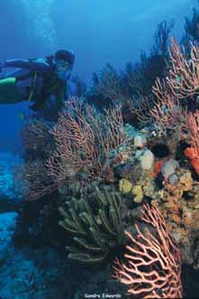
13 ReefBase Objectives Develop a relational database and information system for structured information on coral reefs and their resources that will serve as a computerized encyclopedia and analytical tool for use in reef management, conservation, and research. Florida Keys sponge and seafan

14 ReefBase Objectives Provide key information to support decision-making by fisheries and environmental managers in developing countries, especially those concerned with improving the livelihoods of poor fishers. Elkhorn coral and a club tip finger coral in the foreground

15 ReefBase Objectives Collaborate with other national, regional, and international databases, and GIS facilities relating to reefs, and provide a means of comparing and interpreting information at the global level. Horse conch in sand and coral rubble

16 ReefBase Objectives Define criteria for reef health and use them to refine procedures for coral reef assessments and to determine coral reef status at the regional and global level. And examine the relationships among coral reef health, fishery production, and the quality of life of people dependent on reefs. Two four-eyed butterfly fish in the Keys
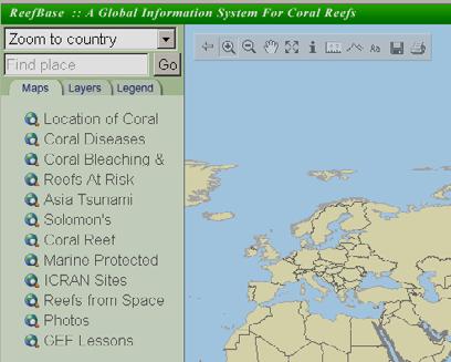
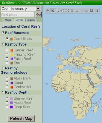
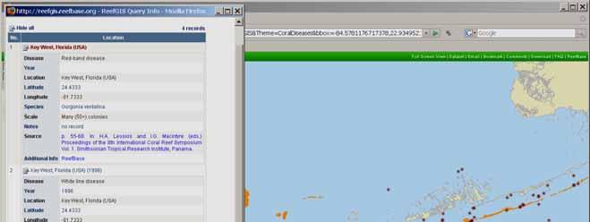
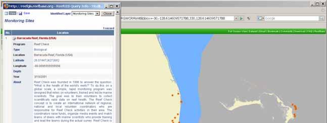
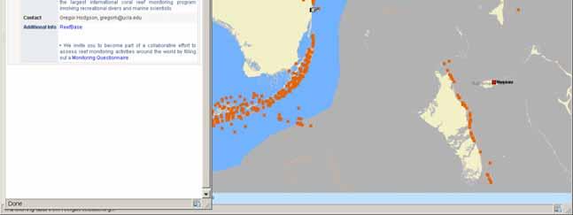
17 ReefBase GIS Base Map
18
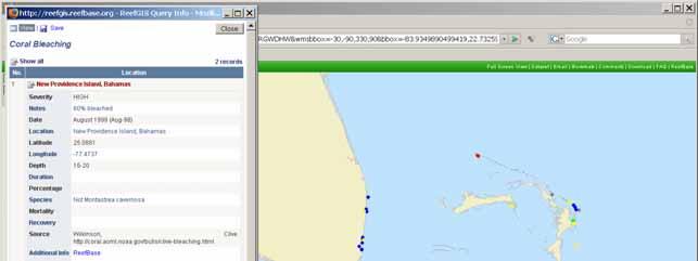
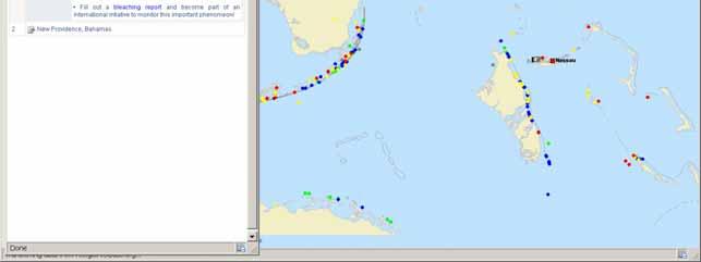
19
20

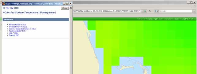
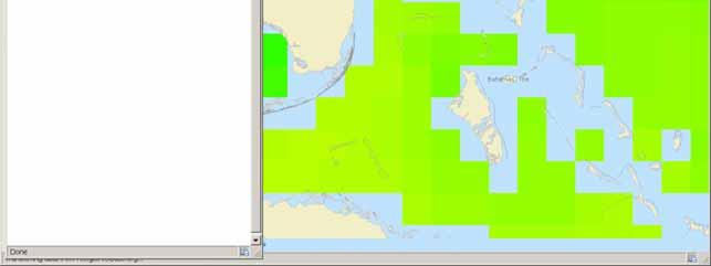
21 Florida and Bahamas coral reef locations

22 Florida and Bahamas reefs from space

23 Florida and Bahamas reefs at risk

24

25 Florida and Bahamas monitored reefs
26

27 Florida and Bahamas coral bleaching
28

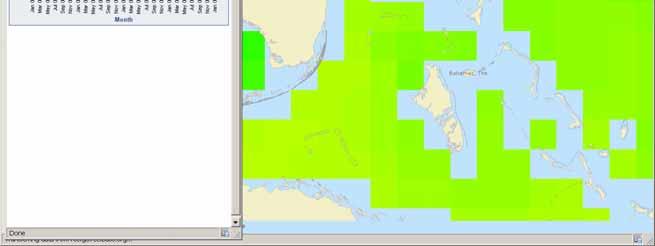
29 Sea surface temperatures SST
30


31 You may use these datasets for non-commercial purposes, including research, education, presentations, and non-commercial publications.

32 Conclusion This study of ReefBase is meant to demonstrate that GIS plays an integral role in defending coral reefs from climate change and other threats while providing the collective tool to integrate multifaceted data and transform them into a meaningful medium for informed decision-making. Green moray eel

33 Reefs At Risk data provided by World Resources Institute (WRI) Phone: +60 (0) Fax: +60 (0) Website: Images courtesy of the NOAA Photo Gallery
34
BENEFITS OF HAVING REEFS. Economic evaluation Belize reefs: WRI Challenges facing coral reefs: Monitoring for solutions
 Challenges facing coral reefs: Monitoring for solutions first reefs end Ordovician Late Devonian end Permian first Scleractinia end Triassic K/T Siluri Ordovician an Devonian Carboniferous Permian Triassic
December 23 rd, 2018 Sample Current Affairs
 December 23 rd, 2018 Sample Current Affairs 1. The coral reef cover in Lakshadweep has shrunk by as much as 40% in just 18 years Why the coral reefs in Lakshadweep are being eroded so fast? How do climate
TOWARDS CLIMATE-RESILIENT COASTAL MANAGEMENT: OPPORTUNITIES FOR IMPROVED ICZM IN BELIZE
 TOWARDS CLIMATE-RESILIENT COASTAL MANAGEMENT: OPPORTUNITIES FOR IMPROVED ICZM IN BELIZE CHANTALLE SAMUELS Coastal Zone Management Authority and Institute The Caribbean Community Climate Change Centre VULNERABILITY
Global Environment Facility - Integrating Watershed & Coastal Areas Management (GEF-IWCAM): Andros Demonstration Site
: Andros Demonstration Site") Global Environment Facility - Integrating Watershed & Coastal Areas Management (GEF-IWCAM): Andros Demonstration Site Coastal Aquifer Management in Small Island Developing States of the Caribbean: Challenges
Global Environment Facility - Integrating Watershed & Coastal Areas Management (GEF-IWCAM): Andros Demonstration Site Coastal Aquifer Management in Small Island Developing States of the Caribbean: Challenges
IMA s ROLE IN COASTAL AND OCEAN GOVERNANCE IN TRINIDAD AND TOBAGO
 IMA s ROLE IN COASTAL AND OCEAN GOVERNANCE IN TRINIDAD AND TOBAGO Presented by Rahanna Juman, Deputy Director (Ag.) About the Institute of Marine Affairs Institute of Marine Affairs (IMA) was established,
Population Trends Along the Coastal United States:
 Coastal Trends Report Series Population Trends Along the Coastal United States: 1980-2008 U.S. Department of Commerce National Oceanic and Atmospheric Administration National Ocean Service Assessing the
OCEANS, CORAL REEFS NOAA
 1 of 5 From the HORIZON Solutions Site, www.solutions-site.org OCEANS, CORAL REEFS NOAA Helps National Coral Reef Institute Grow Coral in Laboratory for Transplantation to Damaged Reefs By Mar 2, 2008,
Sister Sanctuaries: Linking the Science and Management of Coral Reefs in Cuba and the U.S.
 Sister Sanctuaries: Linking the Science and Management of Coral Reefs in Cuba and the U.S. Memorandum of Understanding on Cooperation in the Conservation and Management of Marine Protected Areas Seventh
Courtesy of John Mitchell
 Shrimp trawl fisheries Marine fish stocks are under increasing threat from a range of spatially based problems that might be natural or involve socio-economic factors. To best manage spatial problems,
MPAs - do we need them?
 MPAs - do we need them? Thomas Peschak We all want healthy oceans We all want healthy oceans Our Natural Heritage conserved for future generations We all want healthy oceans To enjoy our sea and the economic
Introduction: The Gulf of Mexico Alliance. The Gulf GAME project MERMAid and PHINS Results & Conclusions What s next? Examples
 AAG Las Vegas March 25, 2009 Introduction: Ocean governance and Ecosystem-Based Management The Gulf of Mexico Alliance Habitat Identification and Characterization The Gulf GAME project MERMAid and PHINS
Why Are Communities at Risk from Coastal Hazards?
 Chapter 2 Why Are Communities at Risk from Coastal Hazards? The Indian Ocean Tsunami of December 2004 raised awareness worldwide of the potentially devastating impacts of tsunamis. Coastal communities
Mapping Maine s Working Waterfront: for Our Heritage and Economy
 Mapping Maine s Working Waterfront: for Our Heritage and Economy Abstract Mapping Maine s Working Waterfronts is a collaborative project led by the Island Institute that inventories the state s current
NOAA s OCM: Services, tools and collaboration opportunities & Puerto Rico s NE Marine Corridor as a case study
 NOAA s OCM: Services, tools and collaboration opportunities & Puerto Rico s NE Marine Corridor as a case study Dr. Antares Ramos Álvarez NOAA s Office of Coastal Management September 15 th, 2016 Conservation
CORAL REEFS IN HOT WATER
 CORAL REEFS IN HOT WATER Coral reef ecosystems are in trouble. About 20 percent of the world s coral reefs have already been lost, and that number may climb to 50 percent in the next 20 to 40 years. The
Heather Schlosser Army Corps of Engineers Coastal Studies Group August 28, 2008
 Got sand? Regional Sediment Management in Orange County Heather Schlosser Army Corps of Engineers Coastal Studies Group August 28, 2008 Regional Sediment Management Regional sediment management recognizes
Kyoto and Carbon Initiative - the Ramsar / Wetlands International perspective
 Kyoto and Carbon Initiative - the Ramsar / Wetlands International perspective (the thoughts of Max Finlayson, as interpreted by John Lowry) Broad Requirements Guideline(s) for delineating wetlands (specifically,
Louis-François Guerre, Planet Action Coordinator Copenhagen, December Spot Image 2007
 Louis-François Guerre, Planet Action Coordinator Copenhagen, December 2009 1 Spot Image 2007 Spot Image, Earth Observation and geo-information services Satellite operator, imagery distributor SPOT4 SPOT5
Coastal marine ecosystems and Integrated Coastal Zone Management (ICZM); A way forward?
; A way forward?") Coastal marine ecosystems and Integrated Coastal Zone Management (ICZM); A way forward? Erlend Moksness Topic Session S13: Risk management in coastal zone ecosystems around the North Pacific PICES Annual
Coastal marine ecosystems and Integrated Coastal Zone Management (ICZM); A way forward? Erlend Moksness Topic Session S13: Risk management in coastal zone ecosystems around the North Pacific PICES Annual
Building capacity to support decisionmaking for protection and management of marine areas
 Credit_Deep Atlantic Stepping Stones Science Team_IFE_URI_NOAA_no3 Credit: John Weller, john@lastocean.com Credit: John Weller, john@lastocean.com Credit: John Weller, john@lastocean.com Credit: Sarah
Sri Lanka has a coastline of km excluding the shoreline of bays and inlets.
 Defining and Demarcating Coastal zones in Sri Lanka Procedure, Challenges and What needs to be done? Dr. Anil Premaratne Director General Coast Conservation Coast Conservation Department Sri Lanka 1 Sri
III. Distribution and Abundance of Acropora Corals
 III. Distribution and Abundance of Acropora Corals Background The declines in abundance of two of the principal Caribbean reef-building corals, staghorn coral (Acropora cervicornis) and elkhorn coral (A.
Lorna V Inniss, Ph.D SAGE Workshop, New York City
 Lorna V Inniss, Ph.D SAGE Workshop, New York City 2014-05-21 Why me? The globally recognized success of the Barbados ICZM programme has generated requests for technical assistance and CD from many Governments
Outline. - Background of coastal and marine conservation - Species distribution modeling (SDM) - Reserve selection analysis. - Results & discussion
 - Reserve selection analysis. - Results & discussion") Application of GIS for data preparation and modeling for coastal and marine conservation planning in Madagascar Rija Rajaonson Technical Assistant, REBIOMA Wildlife Conservation Society Madagascar Outline
Application of GIS for data preparation and modeling for coastal and marine conservation planning in Madagascar Rija Rajaonson Technical Assistant, REBIOMA Wildlife Conservation Society Madagascar Outline
BLUEFIELDS EMERGENCY PLATFORM:
 BLUEFIELDS EMERGENCY PLATFORM: Community Early Warning Systems for Mitigating Hydro-Meteorological Impacts in Bluefields, Jamaica T. Hyman, J. Horney, B. Carby, K. Miller, M. Taylor OUTLINE Background
The Socio Economic Development of the Marine Sector in the Atlantic Area. Stephen Hynes
 The Socio Economic Development of the Marine Sector in the Atlantic Area Stephen Hynes Overview SEMRU and its role in Marine Socioeconomic analysis Defining Ocean and Coastal Economies in the Atlantic
Empowered lives. Resilient nations. Data for People and Planet. powered by
 Empowered lives. Resilient nations. Data for People and Planet powered by Overview As we enter the fourth industrial revolution, technology is revolutionizing our ability to map nature. Satellite data
Rising Sea Levels: Time for Proactive Action in Florida and the Caribbean?
 Rising Sea Levels: Time for Proactive Action in Florida and the Caribbean? Dr. Alan Fyall and Dr. Thomas Wahl National Center for Integrated Coastal Research, University of Central Florida Dr. Roberta
IV. Distribution and Abundance of Acropora Corals
 IV. Distribution and Abundance of Acropora Corals Background The declines in abundance of two of the principal Caribbean reef-building corals, staghorn coral (Acropora cervicornis) and elkhorn coral (A.
Designing Networks of Marine Protected Areas in DFO s Three Atlantic Bioregions
 Designing Networks of Marine Protected Areas in DFO s Three Atlantic Bioregions Presentation for Indigenous Protected Areas Workshop Max Westhead, DFO and Adrian Gerhartz-Abraham, Dalhousie March 29, 2017
Climate Change Impacts, Adaptation and Vulnerability: Small Islands - South West Pacific
 Climate Change Impacts, Adaptation and Vulnerability: Small Islands - South West Pacific Penehuro F. Lefale Lead Author (LA), Chapter 16 Manager, International Cooperation & Development NZ Meteorological
CLIMATE CHANGE A THREAT TO THE FUTURE SUSTAINABLE DEVELOPMENT IN THE CARIBBEAN. U Trotz CCCCC
 CLIMATE CHANGE A THREAT TO THE FUTURE SUSTAINABLE DEVELOPMENT IN THE CARIBBEAN 1 Key Observations from the IPCC IV Assessment Temperature trend from actual observations "Warming of the climate system is
Session 2: Reports from ICRI bodies GCRMN updates
 Session 2: Reports from ICRI bodies GCRMN updates Tadashi Kimura Japan Wildlife Research Center 29 th ICRI General Meeting 20 st -23 rd October 2014, Okinawa Institute of Science and Technology GCRMN SOUTH
Application #: TEXT
 TOWN OF FORT MYERS BEACH 2008 PROPOSED COMPREHENSIVE PLAN AMENDMENTS Application #: 2008-13-TEXT Description: Modify the Coastal Management and Future Land Use Elements to reflect the state s new definition
Sea Level Rise and Coral Reefs: Predicting Responses. Pamela Hallock College of Marine Science University of South Florida St. Petersburg, FL 33701
 Sea Level Rise and Coral Reefs: Predicting Responses Pamela Hallock College of Marine Science University of South Florida St. Petersburg, FL 33701 Acknowledgments Funded by EPA's Science To Achieve Results
III. Acropora coral habitat distribution
 2008 Quick Look Report: Miller et al. III. Acropora coral habitat distribution Background The declines in abundance of two of the principal Caribbean reef-building corals, staghorn coral (Acropora cervicornis)
Changes in Ecosystems - Natural Events
 Changes in Ecosystems - Natural Events 8A predict and describe how different types of catastrophic events impact ecosystems such as floods, hurricanes, or tornadoes Textbook pages: 396-406 How can ecosystems
Chapter 32. Australia & New Zealand
 Chapter 32 Australia & New Zealand Lesson 1: Physical Geography of Australia & New Zealand Landforms Australia lies between the Pacific and Indian Oceans in the Southern Hemisphere. Although an island,
Strengthening the Southwestern indian ocean islands network
 Strengthening the Southwestern indian ocean islands network By Said Ahamada Assistant in charge of environment and fisheries said.ahamada@coi-ioc.org ICRI 29 th General Meeting in OKINAWA, October 2014
The Coastal Change Analysis Program and the Land Cover Atlas. Rebecca Love NOAA Office for Coastal Management
 The Coastal Change Analysis Program and the Land Cover Atlas Rebecca Love NOAA Office for Coastal Management Natural Infrastructure = Greater Resilience NOAA C-CAP Regional Land Cover and Change coast.noaa.gov/digitalcoast/data/ccapregional
NOAA/NSTA Symposium: The Heat is On! Climate Change and Coral Reef Ecosystems Saturday, March 21, 2009
 NOAA/NSTA Symposium: The Heat is On! Climate Change and Coral Reef Ecosystems Saturday, 8:00 AM 8:25 AM Welcome, Introductions, Goals for the Symposium Flavio Mendez, Senior Director, NSTA Learning Center
Cambridge International Examinations Cambridge International General Certificate of Secondary Education
 Cambridge International Examinations Cambridge International General Certificate of Secondary Education *0123456789* ENVIRONMENTAL MANAGEMENT 0680/01 Paper 1 Theory For Examination from 2019 SPECIMEN PAPER
Newsletter # 2. Pilot sites in Greece. December 2018
 A HarmonizEd framework to Mitigate coastal EroSion promoting ICZM protocol implementation Newsletter # 2 December 2018 View of a beach in Ammolofi ( Paggaio Municipality ) Pilot sites in Greece 1. Name
Taxonomy and Systematics: a broader classification system that also shows evolutionary relationships
 Taxonomy: a system for naming living creatures Carrolus Linnaeus (1707-1778) The binomial system: Genus and species e.g., Macrocystis pyrifera (Giant kelp); Medialuna californiensis (halfmoon) Taxonomy
Chapter 32. Australia & New Zealand
 Chapter 32 Australia & New Zealand Lesson 1: Physical Geography of Australia & New Zealand Landforms Australia lies between the Pacific and Indian Oceans in the Southern Hemisphere. Although an island,
Seabed knowledge In support of UN SDGs
 Seabed knowledge In support of UN SDGs Evert Flier Fiskerifaglig forum 2. november 2017 Hydrography & small scale fishing Hydrography in Transition Serving the Maritime Community Hydrography in Transition
Mapping Coastal Change Using LiDAR and Multispectral Imagery
 Mapping Coastal Change Using LiDAR and Multispectral Imagery Contributor: Patrick Collins, Technical Solutions Engineer Presented by TABLE OF CONTENTS Introduction... 1 Coastal Change... 1 Mapping Coastal
Disaster Management & Recovery Framework: The Surveyors Response
 Disaster Management & Recovery Framework: The Surveyors Response Greg Scott Inter-Regional Advisor Global Geospatial Information Management United Nations Statistics Division Department of Economic and
Keywords: climate change, sustainable tourism development, resilience, adaptation. Key Messages: Introduction
 Keywords: climate change, sustainable tourism development, resilience, adaptation Key Messages: Belize s tourism industry is highly vulnerable to the potential adverse impacts of climate change, which
T he O utlet: Almirante
 T he O utlet: Almirante For me, the sea is life. This understanding also holds true with our rivers. Each are alive, and carry life with them as they reach the sea. Our rivers, are born up high in the
Marine Spatial Planning in Hellas; Recent Facts and Perspectives
 XXV FIG CONGRESS Engaging the Challenges, Enhancing the Relevance Kuala Lumpur, Malaysia 16 21 June 2014 Marine Spatial Planning in Hellas; Recent Facts and Perspectives Mrs. Chaiditsa BOLANOU Surveying
GREEN GROWTH TOOLBOX. Nature-Friendly Planning. Jeff Marcus North Carolina Wildlife Resources Commission
 GREEN GROWTH TOOLBOX Nature-Friendly Planning Jeff Marcus North Carolina Wildlife Resources Commission Growth in North Carolina NC is the 5 th fastest growing state 3 million people will move to NC over
Coral Reef Electronic Chart Initiative: Protecting Corals, Saving Ships
 Proceedings: US Hydrographic Conference 2005, 29-31 March 2005, San Diego, CA Coral Reef Electronic Chart Initiative: Protecting Corals, Saving Ships Dr. Lee Alexander Center for Coastal and Ocean Mapping
HELSINKI COMMISSION Baltic Marine Environment Protection Commission
 HELSINKI COMMISSION Baltic Marine Environment Protection Commission HELCOM RECOMMENDATION 24/10 Adopted 25 June 2003, having regard to Article 20, Paragraph 1 b) of the 1992 Helsinki Convention IMPLEMENTATION
Catastrophic Events Impact on Ecosystems
 Catastrophic Events Impact on Ecosystems Hurricanes Hurricanes An intense, rotating oceanic weather system with sustained winds of at least 74 mph and a welldefined eye Conditions for formation: Warm water
Marine Geomorphology as a Determinant for Essential Life Habitat III
 Marine Geomorphology as a Determinant for Essential Life Habitat III marinecoastalgis.net/aag08 10:10 Dawn Wright, Oregon 10:30 Will McClintock, California 10:50 Daniel Sampson, Massachusetts 11:10 Gary
Staghorn Corals and Climate Change
 Better to burn out than to phade away? Summary As well as being the most biodiverse ecosystems in the marine realm, coral reefs provide protein, livelihoods and services to tens of millions of people worldwide.
5/10/15. Chapter 16: Marine Communities. Biomes and Ecosystems
 Chapter 16: Marine Communities Biomes and Ecosystems Biomes are defined as "the world's major communi'es, classified according to the predominant vegeta;on and characterized by adapta;ons of organisms
Analysis of Environmental Impacts from the Port of Miami Expansion. Julienne Beblo
 Analysis of Environmental Impacts from the Port of Miami Expansion Julienne Beblo 6.28.16 The Port of Miami One of the most prominent ports for global tourism and commerce Contributes $28 billion/yr to
Quantifying Climate Impacts on Sustainable Livelihoods in Coastal Caribbean Communities: The Development of a Vulnerability Index
 Quantifying Climate Impacts on Sustainable Livelihoods in Coastal Caribbean Communities: The Development of a Vulnerability Index Sherry Ann Ganase, Sandra Sookram, Sonja Teelucksingh and Patrick Watson
Santos Alvarado Juanita Casanova Ana Cavazos Gayle Robinson Lupita Sanchez 1900 Galveston Hurricane ESS Analysis
 1900 Galveston Hurricane ESS Analysis Problem Statement: Hurricanes are natural disasters that are presented every year; they cause catastrophic disaster to the area they approach. The problem is that
5th Caribbean Environmental Forum and Exhibition (CEF 5) Montego Bay, Jamaica June 21-25, 2010
 Montego Bay, Jamaica June 21-25, 2010") 5th Caribbean Environmental Forum and Exhibition (CEF 5) Montego Bay, Jamaica June 21-25, 2010 Watershed Modeling in the Caribbean: Application of Geographic Information Systems (GIS) in the Assessment
5th Caribbean Environmental Forum and Exhibition (CEF 5) Montego Bay, Jamaica June 21-25, 2010 Watershed Modeling in the Caribbean: Application of Geographic Information Systems (GIS) in the Assessment
The European Union and its Overseas Entities
 The European Union and its Overseas Entities Strategies in the face of climate change and biodiversity loss Reunion Island, 07-11 July 2008 An official event under the EU French Presidency International
Regional-scale understanding of the geologic character and sand resources of the Atlantic inner continental shelf, Maine to Virginia
 Regional-scale understanding of the geologic character and sand resources of the Atlantic inner continental shelf, Maine to Virginia Workshop on Dredging, Beach Nourishment and Bird Conservation Atlantic
SAFMC Habitat and Ecosystem IMS. Habitat and Environmental Protection Advisory Panel Meeting
 SAFMC Habitat and Ecosystem IMS Habitat and Environmental Protection Advisory Panel Meeting Charleston, SC November 18, 2008 Project Overview Phase 1 develop and host an Internet Map Server (IMS) application
Marine/Maritime Spatial Planning Andrej Abramić
 Marine/Maritime Spatial Planning Andrej Abramić EcoAqua SUMMER SCHOOL: Ecosystem approach to aquaculture 26-29th of October 2015 Research and Technology to enhance excellence in Aquaculture development
International Air Safety & Climate change conference
 International Air Safety & Climate change conference 08-09 September 2010, Koln, EASA Stéphanie STOLTZ Project Officer 'Aeronautics' Directorate 'Transport, Directorate-General for Research European Commission
Cross-border Maritime Spatial Plan for the Black sea - Romania and Bulgaria project
 Cross-border Maritime Spatial Plan for the Black sea - Romania and Bulgaria project in Romania and Bulgaria Plan Presentation A first step in the management of the marine areas of Romania and Bulgaria
Table-Top Exercise for Emergency Preparedness Evaluation: Little Anse, Isle Madame
 Table-Top Exercise for Emergency Preparedness Evaluation: Little Anse, Isle Madame Alexander Chung, M.Sc. Candidate C-Change Student Research Associate May 2013 The Community of Little Anse Coastal community
Business Preparedness and Hurricane Risk
 Business Preparedness and Hurricane Risk Hurricanes are one of the more predictable natural disasters compared to events such as earthquakes, wildfires and tornadoes. Meteorologists gather data to predict
Exploring the impacts of future global change on mangrove-fishery-community linkages
 Exploring the impacts of future global change on mangrove-fishery-community linkages Rachel Seary University of Cambridge/ UNEP-WCMC Supervisors: Dr Tom Spencer, Dr Mike Bithell & Dr Chris McOwen Photograph:
Developed in Consultation with Florida Educators
 Developed in Consultation with Florida Educators Table of Contents Next Generation Sunshine State Standards Correlation Chart... 7 Benchmarks Chapter 1 The Practice of Science...................... 11
Learning Objectives: I can identify and interpret river flows and directions.
 Learning Objectives: I can identify and interpret river flows and directions. Bellringer Review: Check for Understanding Questions: 1 2 What Are The Key Parts Of A River s Anatomy? In your data notebooks
Dr. Biliana Cicin-Sain President, Global Ocean Forum 1
 Towards a Sustainable Development Goal on Oceans and Seas: Healthy, Productive and Resilient Oceans and Seas- Prosperous and Resilient Peoples and Communities Dr. Biliana Cicin-Sain President, Global Ocean
Chapter 1 Study Guide
 Chapter 1 Study Guide Reminders: Vocabulary quiz and test will be on Tuesday, September 6th. Complete study guide and bring completed to school Friday, September 2nd. You are NOT required to print the
Together towards a Sustainable Urban Agenda
 Together towards a Sustainable Urban Agenda The City We (Youth) Want Preliminary findings from youth consultations Areas Issue Papers Policy Units 1.Social Cohesion and Equity - Livable Cities 2.Urban
An international research expedition assess the biodiversity and health of New Caledonia coral reefs
 Nouméa, 28.11.2013. An international research expedition assess the biodiversity and health of New Caledonia coral reefs A research mission on coral reefs in New Caledonia conducted in association with
OCEANOGRAPHIC DATA MANAGEMENT
 OCEANOGRAPHIC DATA MANAGEMENT Presented to: Environmental Disaster Data Management Meeting Russ Beard Director, National Coastal Data Development Center Interim Science Coordinator, Gulf Restoration Council
Da Nang Vietnam November 2015
 WORKSHOP Contribution of Valuation Economy Study to the zoning process for proposed Tun Mustapha Marine Park (TMP) and Semporna Marine Spatial Planning Da Nang Vietnam November 2015 Da Nang Vietnam November
Hurricane Katrina and Oil Spills: Impact on Coastal and Ocean Environments
 Archived version from NCDOCKS Institutional Repository http://libres.uncg.edu/ir/asu/ Pine, J. C. (June 2006). Hurricane Katrina and oil spills: Impact on coastal and ocean environments. Oceanography,
Implementing Rio+20: Integrated Planning For Sustainable Coastal Area Management In the Caribbean Region
 Expert Group Meeting Implementing Rio+20: Integrated Planning For Sustainable Coastal Area Management In the Caribbean Region Address by Ronny Jumeau Seychelles Ambassador for Climate change And SIDS Issues
FINAL EXAM PRACTICE #3: Meteorology, Climate, and Ecology
 FINAL EXAM PRACTICE #3: Meteorology, Climate, and Ecology 1. Clay is watching the weather to prepare for a trip to the beach tomorrow. The forecast predicts that a low-pressure system will move in overnight.
Wetland Programmes. Biodiversity assessments in determining wetland conservation priorities: a catchment approach. Dr. Piet-Louis Grundling
 CHIEF DIRECTORATE NATURAL RESOURCE MANAGEMENT PROGRAMMES: Wetland Programmes Biodiversity assessments in determining wetland conservation priorities: a catchment approach Dr. Piet-Louis Grundling Environmental
3.3 Threats to Biodiversity
 Name: Date: Class: IB Environmental Systems and Societies 3.3 Threats to Biodiversity Significant ideas: While global biodiversity is difficult to quantify, it is decreasing rapidly due to human activity.
ARCTIC FISHERIES: GOVERNANCE CHALLENGES AND OPPORTUNITIES
 Commentary ARCTIC FISHERIES: GOVERNANCE CHALLENGES AND OPPORTUNITIES FRANK MILLERD JULY 2011 Contact: fmillerd@wlu.ca Professor Emeritus, Department of Economics, Wilfrid Laurier University. Contact: fmillerd@wlu.ca.
Economic Valuation of Goods and Services Derived from Coral Reefs. Results from the Tobago Cays Marine Park Reeffix Exercise
 Economic Valuation of Goods and Services Derived from Coral Reefs Results from the Tobago Cays Marine Park Reeffix Exercise Table of Contents Background Project Background Overview of Economic Valuation
Cambridge International Examinations Cambridge International Advanced Subsidiary and Advanced Level
 Cambridge International Examinations Cambridge International Advanced Subsidiary and Advanced Level *0627433796* MARINE SCIENCE 9693/01 Paper 1 AS Structured Questions October/November 2016 1 hour 30 minutes
NOAA S Arctic Program in 2017
 NOAA S Arctic Program in 2017 NOAA s Arctic Mission To determine how the Arctic system is changing on time scales of weeks to decades, particularly with respect to the consequences that the loss of sea
Liana Talaue McManus. Division of Marine Affairs and Policy Rosenstiel School of Marine & Atmospheric Science University of Miami
 Liana Talaue McManus Division of Marine Affairs and Policy Rosenstiel School of Marine & Atmospheric Science University of Miami Outline 1. Coasts as vulnerable & resilient social ecological systems 2.
Current experiences in the use of satellite information in development aid activities
 Current experiences in the use of satellite information in development aid activities Meeting at ESA/ESRIN in Frascati 16 th of September 2017 #WorldInCommon AGENCE FRANÇAISE DE DÉVELOPPEMENT FRENCH DEVELOPMENT
M14/3/GEOGR/SP2/ENG/TZ0/XX/Q GEOGRAPHY STANDARD LEVEL PAPER 2. Monday 19 May 2014 (morning) 1 hour 20 minutes INSTRUCTIONS TO CANDIDATES
 1 hour 20 minutes INSTRUCTIONS TO CANDIDATES") M14/3/GEOGR/SP2/ENG/TZ0/XX/Q 22145203 GEOGRAPHY STANDARD LEVEL PAPER 2 Monday 19 May 2014 (morning) 1 hour 20 minutes INSTRUCTIONS TO CANDIDATES Do not open this examination paper until instructed to do
M14/3/GEOGR/SP2/ENG/TZ0/XX/Q 22145203 GEOGRAPHY STANDARD LEVEL PAPER 2 Monday 19 May 2014 (morning) 1 hour 20 minutes INSTRUCTIONS TO CANDIDATES Do not open this examination paper until instructed to do
THE EFFECTS OF CLIMATE CHANGE ON THE TOURISM INDUSTRY IN SOUTHEAST ASIA WITH A SPECIFIC ANALYSIS OF THE CASE OF PATTAYA, THAILAND
 i THE EFFECTS OF CLIMATE CHANGE ON THE TOURISM INDUSTRY IN SOUTHEAST ASIA WITH A SPECIFIC ANALYSIS OF THE CASE OF PATTAYA, THAILAND Name School Course Date ii Abstract Climate change has already made an
Geospatial Decision Support Tools for Planning of Marine Protected Areas in California
 Geospatial Decision Support Tools for Planning of Marine Protected Areas in California WILL MCCLINTOCK (UNIVERSITY OF CALIFORNIA SANTA BARBARA), MATT MERRIFIELD (THE NATURE CONSERVANCY), SOPHIE DE BEUKELAER
Terms of Reference for developing thematic maps and establishing a GIS baseline of vulnerable reefs in the MAR region
 Terms of Reference for developing thematic maps and establishing a GIS baseline of vulnerable reefs in the MAR region 1. Introduction Mesoamerican Reef Rescue Initiative The Mesoamerican Reef Fund (MAR
Coastal Response Research Center. Nancy Kinner University of New Hampshire (UNH) Michele Jacobi NOAA ORR. September 27, 2007
 Michele Jacobi NOAA ORR. September 27, 2007") Coastal Response Research Center Nancy Kinner University of New Hampshire (UNH) Michele Jacobi NOAA ORR September 27, 2007 1 Coastal Response Research Center (CRRC) CRRC is partnership between NOAA s Office
Coastal Response Research Center Nancy Kinner University of New Hampshire (UNH) Michele Jacobi NOAA ORR September 27, 2007 1 Coastal Response Research Center (CRRC) CRRC is partnership between NOAA s Office
This table connects the content provided by Education Perfect to the NSW Syllabus.
 Education Perfect Geography provides teachers with a wide range of quality, engaging and innovative content to drive positive student learning outcomes. Designed by teachers and written by our in-house
U.S. Data on the Ocean and Coastal Economy: An Introduction
 U.S. Data on the Ocean and Coastal Economy: An Introduction Linwood Pendleton Acting Chief Economist, NOAA Director of Ocean and Coastal Policy, Duke slides and data contributed by: Jeff Adkins, Percy
FINDINGS OF THE IPCC FOURTH ASSESSMENT REPORT IMPLICATIONS FOR ADAPTATION IN SMALL VULNEARABLE COMMUNITIES
 FINDINGS OF THE IPCC FOURTH ASSESSMENT REPORT IMPLICATIONS FOR ADAPTATION IN SMALL VULNEARABLE COMMUNITIES UNFCCC Article 6 Workshop for SIDS Carlos Fuller, Deputy Director, Caribbean Community Climate
International Journal of Scientific & Engineering Research, Volume 6, Issue 11, November ISSN
 International Journal of Scientific & Engineering Research, Volume 6, Issue 11, November-2015 42 Geospatial Mapping of Fish Farms in Anambra State Using GIS Approach Ojiako, J.C., Okafor, C. M., Igbokwe,
DWH Restoration Funding at a Glance
 NCER 2018 DWH Restoration Funding at a Glance Natural Resource Damage Assessment: $8.1 Billion RESTORE Act: $5.3 Billion National Fish and Wildlife Foundation GEBF: $2.5 Billion National Academy of Sciences: