Keywords: climate change, sustainable tourism development, resilience, adaptation. Key Messages: Introduction
|
|
|
- Melissa Bradley
- 5 years ago
- Views:
Transcription


1

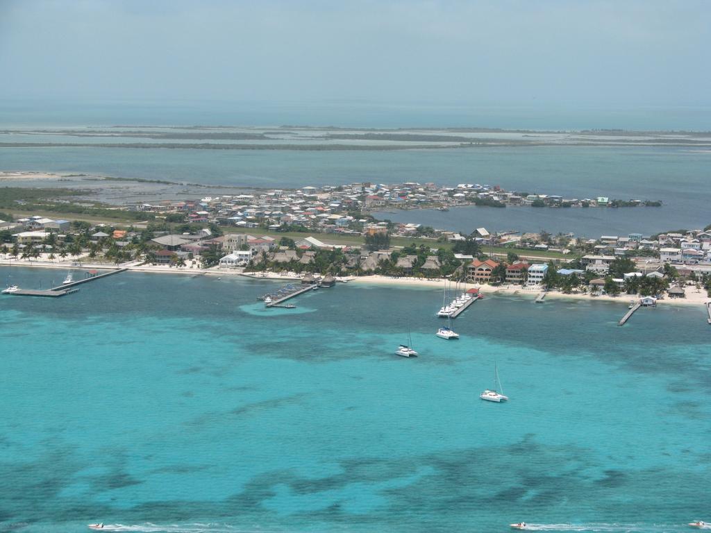
2 Keywords: climate change, sustainable tourism development, resilience, adaptation Key Messages: Belize s tourism industry is highly vulnerable to the potential adverse impacts of climate change, which emphasizes the importance of identifying climate resilient areas. The physical infrastructure, destination sites and natural environment that support Belize s marine-based tourism industry are located within the coastal zone, which increases the vulnerability of the industry to climate change. Vulnerability assessments as presented here identify areas that can be prioritized for adaptation action, and those that can facilitate climate-compatible tourism development opportunities. Policy review and sound development planning can lead to maximum returns from tourism investments. Introduction Global climate change has severe adverse implications for developing countries, such as Belize that are heavily reliant on natural resources for economic growth. Identifying particularly vulnerable areas is therefore critical for ensuring future economic sustainability, especially with regard to the tourism industry, which is the largest contributor to the Belizean economy. Currently, most of the major physical infrastructure, transportation hubs, tourism attractions and hotels that support marine-based tourism are located within the coastal zone. This poses a potential threat for the tourism industry since Belize is particularly vulnerable to climate change impacts. Therefore, conducting vulnerability assessments will help to highlight priority areas for investment in tourism development in climate resilient areas, and will build the adaptive capacity of the industry. In Belize, important attractors for the tourism industry include natural features found within the coastal zone such as the barrier reef, atolls, and several hundred cayes. The existence of these irreplaceable natural features, coupled with the fact that almost 40% of Belize s population resides within coastal areas, emphasizes the importance of including climate adaptation strategies in development planning. As a developing nation, Belize has limited resources available to invest in extensive studies to determine and mitigate projected climate change effects. Thus, vulnerability assessments are an effective and cost efficient tool to anticipate future changes associated with climate change, highlight areas at highest risk, maximize development investment through sound planning, and prioritize adaptation action within industries. Why Conduct Vulnerability Assessments for the Tourism Sector? The Intergovernmental Panel on Climate Change (IPCC) defines vulnerability as "the degree to which a system is susceptible to, and unable to cope with, adverse effects of climate change, including climate variability and extremes" (IPCC, 2007). Vulnerability can vary depending on the characteristics of that system including its exposure, sensitivity, and adaptive capacity (Snover et al., 2007). Using this concept, an assessment of vulnerability can help to identify the structural integrity of tourism infrastructure, estimate the potential for damage and disruption of tourism services, and prioritize areas for implementing adaptive strategies into development planning. These areas, once identified, will become hallmark destinations to attract tourism development that will both decrease investor risk and encourage responsible sustainable development.

, the coastal zone (CATIE/TNC, 2012), resulting in numerous datasets and maps.")
3 Vulnerability Assessment of the Tourism Sector in Belize in Belize With limited resources to invest in adapting to current and future changes, decision makers are faced with tough decision about where to target investment. Identifying particularly vulnerable areas and the factors that contribute to vulnerability can help to inform such decisions. Multiple vulnerability assessments have been carried out in Belize for different geographic areas, sectors and ecosystems, e.g. tourism (Richardson, 2007), mangroves (Cherrington et al., 2010), the coastal zone (CATIE/TNC, 2012), resulting in numerous datasets and maps. Information from these initiatives and other available datasets were reviewed, mapped where possible and aggregated to give a picture of the current status and vulnerability of Belize's coastal areas used for tourism or designated for future tourism development. Therefore, this project funded by CARIBSAVE and the Climate and Development Knowledge Network (CDKN) aims at assessing the current vulnerability of Belize's tourism system to climate change, including the coastal ecosystems on which it depends, and how current policies facilitate or hinder climate-compatible tourism development based on healthy coastal ecosystems Methodology Vulnerability Assessment & Creation of Vulnerability Index Map We created a base map of Belize s tourism system using GIS, which includes the natural environment, physical infrastructure and tourist destinations (Figure 1). This base map was then used to develop a vulnerability ranking for the different tourism areas based on tourism investments and socio-economic contributions. In order to investigate the vulnerability of the tourism system to climate change, data layers representing different indicators of vulnerability (exposure, sensitivity and adaptive capacity) were compiled using GIS (Figures 2 & 3). Each indicator was ranked, and a composite vulnerability index was developed. The resulting vulnerability map shows the relative vulnerability of regions within the coastal zone, which are ranked from low to high vulnerability (Figure 4). Finally, a map was created to identify resilient areas that may be prioritized for future adaptation actions and prioritized for potential future tourism development (Figure 5).


4 Policy Review We conducted a policy review to consider both explicit policies - those that are formulated with the intention to address tourism, coastal/marine health and/or climate change adaptation; and implicit - those that were formulated to address other issues but are relevant in that they influence vulnerability to climate change impacts or ecosystem health. A total of 39 documents were analysed; 24 public policies, strategies and plans, and 15 relevant laws (Acts, Legislations and Regulations. Of these, only 7 effectively accounted for climate changes and related impacts. Potential Effects of Climate Change on Belize s Tourism Sector Exposure indicators to climate change were mapped using the following four critical climate effects on tourism in coastal areas. Rise in sea surface temperature Increased storm intensity Sea Level Rise Changes in rainfall patterns and air temperature Rise in sea surface temperature Exposure Sensitivity Figure 2: Exposure to thermal stress from (Source: CATIE/TNC, 2012) Figure 3: Reef sensitivity to sea surface warming from (Source: CATIE/TNC, 2012) The level of exposure to thermal stress in the study area from 2006 to 2010 was mapped as seen in Figure 2. Bleaching occurred mainly in northern Ambergris Caye, South Belize City, Turneffe Atoll Marine Reserve, South Central Region and Southern Region during this period. Various areas are also undergoing thermal stress, demonstrating the need for a monitoring system in the coastal zone to identify bleaching and the capacity of coral reefs to recover. Current and future thermal stress was overlapped with coral reefs as seen in Figure 3. Results indicate that under a thermal stress shows that the coral reef will be exposed and suffering a very high thermal stress, with a high impact. Thus, coral mortality from climate change may reduce the appeal of visitors that would like to participate in underwater recreational activities.
 2 Equation 1: Formula for determining potential climate change impact.")

5 Determining tourism industry vulnerability to climate change A weighted arithmetic aggregation was used to determine the potential impact of climate change to the tourism sector using the following formula: PI = (EX + SE) 2 Equation 1: Formula for determining potential climate change impact. Where PI is the potential impact composite indicator, EX is the vulnerability component exposure, and SE is the vulnerability component sensitivity. Tourism Vulnerability Map Figure 4: Vulnerability Index of Belize's Tourism System Figure 5: Areas for Climate-Compatible Tourism Development The highest potential impact to the tourism areas will be to the popular destination of Ambergris Caye, Central Region, South Central Region and Southern Region (Figure 4). Hence, there is a need to prioritize these areas for adaptation interventions. Less vulnerable hotspots for climate-compatible tourism development were identified as seen in Figure 5. This assessment also illustrates areas that may be prioritized for future research into their potential for climate-compatible tourism development. These include: Northern Region, Caye Caulker and South Northern Region. Policy Recommendations: The following key policies recommendations are urgently required to help bolster the country s ability to adequately address climate change threats with the appropriate actions that will minimize the impacts: National Sustainable Tourism Master Plan - revise to integrate green climate adaptation options to help deal with current and future disaster risk reduction (DRR) and climate risk factors within the tourism development landscape. Coastal Zone Management (CZM) Act - ensure that the CZM Act is effectively revised to grant greater protection to Belize's coastal habitats, including those beyond the high water mark, and that it is climate-smart to sufficiently address risks and vulnerabilities posed by a changing climate. A revised CZM Act will also grant greater strength to the implementation of the Belize Integrated Coastal Zone Management Plan. Environmental Impact Assessment (EIA) Regulations - ensure that the EIA Regulations, including associated development checklist, fully call for the accounting of the value of nature in combating risks and vulnerability related to climate change effects Mangrove Regulations - revise/update the mangrove regulation of grant greater protection to mangroves, and reflecting the critical goods and services provided by these ecosystems in buffering against climate impacts; climate-smart the regulation. Horizon 2030 Development Plan - need to clearly account for the influence (negative or positive) of climate change on our environmental, social, and economic sectors. Belize's main economies are nature-based and climate change may compromise some of the benefits we are receiving from nature if appropriate planning and management actions are not set in place.

 / World Wildlife Fund. Panama City, Panama. 33 pp. Available online: http://maps.cathalac.")
6 References: CATIE/TNC, 2012, Climate Change vulnerability Analysis of the Caribbean Coast of Belize, Guatemala and Honduras. Climate change and watershed Tropical Agricultural Research and Higher Education Centre. Cherrington, E, Hernandez, B, Trejos, N, Smith, O, Anderson, E, Flores, A, and Garcia, B 2010, Identification of threatened and resilient mangroves in the Belize Barrier Reef System. Technical Report. Water Center for the Humid Tropics of Latin America and the Caribbean (CATHALAC) / World Wildlife Fund. Panama City, Panama. 33 pp. Available online: bz_mangroves_ _highres.pdf. Intergovernmental Panel on Climate Change, IPCC 2007, Climate Change 2007: Impacts, Adaptation and Vulnerability. Contribution of Working Group II to the Fourth Assessment Report of the Intergovernmental Panel on Climate Change, eds. M.L. Parry, O.F. Canziani, J.P. Palutikof, P.J. van der Linden and C.E. Hanson. Cambridge, UK : Cambridge University Press, 976 pp. Richardson, R 2007, Tourism in Belize Vulnerability and Capacity Assessment. Michigan, USA: Michigan State University Snover, A.K., Whitely Binder, L, Lopez, J, Willmott E, Kay J, Howell D & Simmonds, J 2007, Preparing for Climate Change: A Guidebook for Local, Regional and State Governments. In association with and published by ICLEI - Local Governments for Sustainability, Oakland, CA. Biography Chantalle Clarke-Samuels is the Director of the Belize Coastal Zone Management Authority and Institute. Nadia Bood is a Reef Scientist and Climate Adaptation Advisor for the World Wildlife Fund Mesoamerican Reef Program. Leandra Cho-Ricketts is the Administrative Director and Marine Science Director at the University of Belize Environmental Research Institute (UB ERI) where she is in charge of the marine science programs at the Institute. For further information on this work contact: Nadia Bood at nbood@wwfca.org and/or Chantalle Clarke-Samuels at directorczmai@gmail.com This document is an output from a project funded by the UK Department for International Development (DFID) for the benefit of developing countries. However, the views expressed and information contained in it are not necessarily those of or endorsed by DFID, which can accept no responsibility for such views or information or for any reliance placed on them. This publication has been prepared for general guidance on matters of interest only, and does not constitute professional advice. No representation or warranty (express or implied) is given as to the accuracy or completeness of the information contained in this publication, and, to the extent permitted by law, the Climate and Development Knowledge Network s members, the UK Department for International Development ( DFID ), their advisors and the authors and distributors of this publication do not accept or assume any liability, responsibility or duty of care for any consequences of you or anyone else acting, or refraining to act, in reliance on the information contained in this publication or for any decision based on it.
TOWARDS CLIMATE-RESILIENT COASTAL MANAGEMENT: OPPORTUNITIES FOR IMPROVED ICZM IN BELIZE
 TOWARDS CLIMATE-RESILIENT COASTAL MANAGEMENT: OPPORTUNITIES FOR IMPROVED ICZM IN BELIZE CHANTALLE SAMUELS Coastal Zone Management Authority and Institute The Caribbean Community Climate Change Centre VULNERABILITY
TERMS OF REFERENCE CONSULTANCY TO DEVELOP CLIMATE PRODUCTS AND SERVICES FOR THE CARIBBEAN TOURISM INDUSTRY (FEASIBILITY STUDY)
") Appendix 2 TERMS OF REFERENCE CONSULTANCY TO DEVELOP CLIMATE PRODUCTS AND SERVICES FOR THE CARIBBEAN TOURISM INDUSTRY (FEASIBILITY STUDY) 1. BACKGROUND 1.01 The Caribbean tourism product depends largely
Appendix 2 TERMS OF REFERENCE CONSULTANCY TO DEVELOP CLIMATE PRODUCTS AND SERVICES FOR THE CARIBBEAN TOURISM INDUSTRY (FEASIBILITY STUDY) 1. BACKGROUND 1.01 The Caribbean tourism product depends largely
The World Bank BZ Marine Conservation and Climate Adaptation (P131408)
") Public Disclosure Authorized LATIN AMERICA AND CARIBBEAN Belize Environment & Natural Resources Global Practice Recipient Executed Activities Investment Project Financing FY 2015 Seq No: 2 ARCHIVED on
Public Disclosure Authorized LATIN AMERICA AND CARIBBEAN Belize Environment & Natural Resources Global Practice Recipient Executed Activities Investment Project Financing FY 2015 Seq No: 2 ARCHIVED on
ACTION PLAN FOR WORLD HERITAGE IN LATIN AMERICA AND THE CARIBBEAN ( )
") Annex ACTION PLAN FOR WORLD HERITAGE IN LATIN AMERICA AND THE CARIBBEAN (2014-2024) The current Regional Action Plan for Latin America and the Caribbean for 2014-2024 has been elaborated by the State Parties
Annex ACTION PLAN FOR WORLD HERITAGE IN LATIN AMERICA AND THE CARIBBEAN (2014-2024) The current Regional Action Plan for Latin America and the Caribbean for 2014-2024 has been elaborated by the State Parties
16540/14 EE/cm 1 DG E 1A
 Council of the European Union Brussels, 5 December 2014 (OR. en) 16540/14 ENV 965 CULT 139 NOTE From: To: Subject: General Secretariat of the Council Delegations Charter of Rome on Natural and Cultural
Rising Sea Levels: Time for Proactive Action in Florida and the Caribbean?
 Rising Sea Levels: Time for Proactive Action in Florida and the Caribbean? Dr. Alan Fyall and Dr. Thomas Wahl National Center for Integrated Coastal Research, University of Central Florida Dr. Roberta
17 th Session of RA IV
 17 th Session of RA IV Agenda Item 4.1: Disaster Risk Reduction, Resilience and Prevention, Focusing on Impact-Based Decision Support Services Doc 4.1.(6):Coastal Inundation Forecasting Demonstration Project
SPLAN-Natura Towards an integrated spatial planning approach for Natura th January, 2017 Brussels. Commissioned by DG Environment
 SPLAN-Natura 2000 Towards an integrated spatial planning approach for Natura 2000 Commissioned by DG Environment 17 th January, 2017 Brussels V. Simeonova (Ph.D.) Drivers towards integrating Biodiversity
CLIMATE CHANGE A THREAT TO THE FUTURE SUSTAINABLE DEVELOPMENT IN THE CARIBBEAN. U Trotz CCCCC
 CLIMATE CHANGE A THREAT TO THE FUTURE SUSTAINABLE DEVELOPMENT IN THE CARIBBEAN 1 Key Observations from the IPCC IV Assessment Temperature trend from actual observations "Warming of the climate system is
Disaster Risk Assessment: Opportunities for GIS and data management with Open DRI
 Disaster Risk Assessment: Opportunities for GIS and data management with Open DRI Jacob Opadeyi Department of Geomatics Engineering and Land Management, The University of the West Indies, St. Augustine,
WELCOME & INTRODUCTION
 MPA Management Capacity Building Training Module 1: WELCOME & INTRODUCTION Participants Distinguished Guests Welcome Site Overviews of MPAs represented Overview of Training Program What are Today s Objectives?
Natura 2000 and spatial planning. Executive summary
 Natura 2000 and spatial planning Executive summary DISCLAIMER The information and views set out in this study are those of the author(s) and do not necessarily reflect the official opinion of the Commission.
Mediterranean Sea and Territorial Development, Opportunities and Risks
 EESC Hearing Towards an EU Macro-Regional Strategy for the Mediterranean Mediterranean Sea and Territorial Development, Opportunities and Risks Michaela Gensheimer Structure of Intervention Part I: What
Improving global coastal inundation forecasting WMO Panel, UR2014, London, 2 July 2014
 Improving global coastal inundation forecasting WMO Panel, UR2014, London, 2 July 2014 Cyclone Sidr, November 2007 Hurricane Katrina, 2005 Prof. Kevin Horsburgh Head of marine physics, UK National Oceanography
Lorna V Inniss, Ph.D SAGE Workshop, New York City
 Lorna V Inniss, Ph.D SAGE Workshop, New York City 2014-05-21 Why me? The globally recognized success of the Barbados ICZM programme has generated requests for technical assistance and CD from many Governments
NOVEMBER 2016 AFRICA S CLIMATE HELPING DECISION MAKERS MAKE SENSE OF CLIMATE INFORMATION FUTURE CLIMATE FOR AFRICA
 NOVEMBER 2016 AFRICA S CLIMATE HELPING DECISION MAKERS MAKE SENSE OF CLIMATE INFORMATION FUTURE CLIMATE FOR AFRICA Trevor Samson/World Bank/Flickr GENERAL READERS SOUTHERN AFRICA REGIONAL OVERVIEW STUDYING
HELSINKI COMMISSION Baltic Marine Environment Protection Commission
 HELSINKI COMMISSION Baltic Marine Environment Protection Commission HELCOM RECOMMENDATION 24/10 Adopted 25 June 2003, having regard to Article 20, Paragraph 1 b) of the 1992 Helsinki Convention IMPLEMENTATION
Climate Resilience Decision Making Framework in the Caribbean. A case of Spatial Data Management
 Climate Resilience Decision Making Framework in the Caribbean A case of Spatial Data Management Bishwa Pandey Sr. Data Management Specialist The World Bank Background The mission of The World Bank s Latin
The European Union and its Overseas Entities
 The European Union and its Overseas Entities Strategies in the face of climate change and biodiversity loss Reunion Island, 07-11 July 2008 An official event under the EU French Presidency International
THE EFFECTS OF CLIMATE CHANGE ON THE TOURISM INDUSTRY IN SOUTHEAST ASIA WITH A SPECIFIC ANALYSIS OF THE CASE OF PATTAYA, THAILAND
 i THE EFFECTS OF CLIMATE CHANGE ON THE TOURISM INDUSTRY IN SOUTHEAST ASIA WITH A SPECIFIC ANALYSIS OF THE CASE OF PATTAYA, THAILAND Name School Course Date ii Abstract Climate change has already made an
THE IMPACT OF EL NIÑO AND LA NIÑA ON SOUTHEAST ASIA
 THE IMPACT OF EL NIÑO AND LA NIÑA ON SOUTHEAST ASIA 21st-23rd February 2000 WORKSHOP SUMMARY Organized by the Indochina Global Change Network Funded by the Asia-Pacific Network for Global Change Research
Chapter 32. Australia & New Zealand
 Chapter 32 Australia & New Zealand Lesson 1: Physical Geography of Australia & New Zealand Landforms Australia lies between the Pacific and Indian Oceans in the Southern Hemisphere. Although an island,
Business Preparedness and Hurricane Risk
 Business Preparedness and Hurricane Risk Hurricanes are one of the more predictable natural disasters compared to events such as earthquakes, wildfires and tornadoes. Meteorologists gather data to predict
CLIMATE RESILIENT ALTITUDINAL GRADIENTS (CRAGs)
") CLIMATE RESILIENT ALTITUDINAL GRADIENTS (CRAGs) BUILDING CLIMATE CHANGE RESILIENCE IN THE KIVU- RUSIZI WATERSHEDS Great Lake Conference Entebbe 2017 Chris Magero WHAT ARE CRAGs? Climate-Resilient Altitudinal
CLIMATE RESILIENT ALTITUDINAL GRADIENTS (CRAGs) BUILDING CLIMATE CHANGE RESILIENCE IN THE KIVU- RUSIZI WATERSHEDS Great Lake Conference Entebbe 2017 Chris Magero WHAT ARE CRAGs? Climate-Resilient Altitudinal
Population Trends Along the Coastal United States:
 Coastal Trends Report Series Population Trends Along the Coastal United States: 1980-2008 U.S. Department of Commerce National Oceanic and Atmospheric Administration National Ocean Service Assessing the
Outline National legislative & policy context Regional history with ESSIM ESSIM Evaluation Phase Government Integration via RCCOM Regional ICOM Framew
 What MSP Implementation could change in the Maritimes Region Tim Hall, Regional Manager Oceans and Coastal Management Division Ecosystem Management Branch Fisheries and Oceans Canada Maritimes Region BIO
Seabed knowledge In support of UN SDGs
 Seabed knowledge In support of UN SDGs Evert Flier Fiskerifaglig forum 2. november 2017 Hydrography & small scale fishing Hydrography in Transition Serving the Maritime Community Hydrography in Transition
Land Use in the context of sustainable, smart and inclusive growth
 Land Use in the context of sustainable, smart and inclusive growth François Salgé Ministry of sustainable development France facilitator EUROGI vice president AFIGéO board member 1 Introduction e-content+
Urban Climate Resilience
 Urban Climate Resilience in Southeast Asia Partnership Project Introduction Planning for climate change is a daunting challenge for governments in the Mekong Region. Limited capacity at the municipal level,
Chapter 32. Australia & New Zealand
 Chapter 32 Australia & New Zealand Lesson 1: Physical Geography of Australia & New Zealand Landforms Australia lies between the Pacific and Indian Oceans in the Southern Hemisphere. Although an island,
Disaster Management & Recovery Framework: The Surveyors Response
 Disaster Management & Recovery Framework: The Surveyors Response Greg Scott Inter-Regional Advisor Global Geospatial Information Management United Nations Statistics Division Department of Economic and
Climate Change in the Pacific: Scientific Assessment and New Research Volume 1: Regional Overview
 Climate Change in the Pacific: Scientific Assessment and New Research Volume 1: Regional Overview Australian Bureau of Meteorology and Commonwealth Scientific and Industrial Research Organisation (CSIRO)
Assessment and valuation of Ecosystem Services for decision-makers
 Assessment and valuation of Ecosystem Services for decision-makers An introduction to the ARIES approach Ferdinando Villa *, Ken Bagstad Gary Johnson, Marta Ceroni *Basque Center for Climate Change, Bilbao,
Geospatial framework for monitoring SDGs/Sendai targets By Shimonti Paul Sr. Assistant Editor Geospatial Media & Communications
 Geospatial framework for monitoring SDGs/Sendai targets By Shimonti Paul Sr. Assistant Editor Geospatial Media & Communications Outline 1. Introduction to Geospatial Media and Communications 2. Geospatial
Together towards a Sustainable Urban Agenda
 Together towards a Sustainable Urban Agenda The City We (Youth) Want Preliminary findings from youth consultations Areas Issue Papers Policy Units 1.Social Cohesion and Equity - Livable Cities 2.Urban
Cultural Routes of the Council of Europe - Glossary
 Cultural Routes of the Council of Europe - Glossary Below is a collection of terms linked to Cultural Routes of the Council of Europe. The glossary is taken from the book Cultural Routes management: from
A Framework for the Study of Urban Health. Abdullah Baqui, DrPH, MPH, MBBS Johns Hopkins University
 This work is licensed under a Creative Commons Attribution-NonCommercial-ShareAlike License. Your use of this material constitutes acceptance of that license and the conditions of use of materials on this
The UN-GGIM: Europe core data initiative to encourage Geographic information supporting Sustainable Development Goals Dominique Laurent, France
 INSPIRE conference Strasbourg 6 September 2017 The UN-GGIM: Europe core data initiative to encourage Geographic information supporting Sustainable Development Goals Dominique Laurent, France Introduction
FINDINGS OF THE ARCTIC METEOROLOGY SUMMIT
 FINDINGS OF THE ARCTIC METEOROLOGY SUMMIT 2018 WWW.FMI.FI CHAIR S SUMMARY: 1 2 3 We need to be curious to explore the known unknowns. Meteorology is an elemental part of international collaboration in
Using Information and Geospatial Technologies to Support Biodiversity Conservation Policy Options in Latin America
 Using Information and Geospatial Technologies to Support Biodiversity Conservation Policy Options in Latin America Cover map credit: Javier Alfonso Racero-Casarrubia Using Information and Geospatial Technologies
THE SEVILLE STRATEGY ON BIOSPHERE RESERVES
 THE SEVILLE STRATEGY ON BIOSPHERE RESERVES 1 VISION FOR BIOSPHERE RESERVES IN THE 21 ST CENTURY The international Seville Conference on Biosphere Reserves, organised by UNESCO, adopted a two-pronged approach,
Which tools were used? How and why?
 Raquel Chun 1, Clare Goodess 2, Ottis Joslyn 1, Colin Harpham 2 1 Caribbean Community Climate Change Centre, Belize 2 University of East Anglia, UK Keywords: Urban development, Flood Risk, Flooding, Extreme
2018/1 The integration of statistical and geospatial information. The Regional Committee of UN-GGIM: Americas:
 The following are the conclusions and recommendations of the Regional Committee of the United Nations on Global Geospatial Information Management for the Americas, during its Fifth Session, Thursday 8
Sri Lanka has a coastline of km excluding the shoreline of bays and inlets.
 Defining and Demarcating Coastal zones in Sri Lanka Procedure, Challenges and What needs to be done? Dr. Anil Premaratne Director General Coast Conservation Coast Conservation Department Sri Lanka 1 Sri
By Lillian Ntshwarisang Department of Meteorological Services Phone:
 By Lillian Ntshwarisang Department of Meteorological Services Phone: +267 3612200 Email: lntshwarisang@gov.bw/ lntshwarisang@gmail.com Introduction Mandate of DMS Function of the Department Services to
Asia Protected Areas Charter
 資料 3-1 Asia Protected Areas Charter The Asia Challenge Asia is the world s most rapidly growing region as well as one of the most bio-diverse. This dynamic development has led to unprecedented growth,
STATUS OF HAZARD MAPS VULNERABILITY ASSESSMENTS AND DIGITAL MAPS
 JapanInternational Cooperation Agency STATUS OF HAZARD MAPS VULNERABILITY ASSESSMENTS AND DIGITAL MAPS ANGUILLA REPORT THE CARIBBEAN DISASTER EMERGENCY RESPONSE AGENCY () Table of Contents Page Preface
TOWARDS STRATEGIC SPATIAL PLANNING IN JAMAICA: THE NATIONAL SPATIAL PLAN
 TOWARDS STRATEGIC SPATIAL PLANNING IN JAMAICA: THE NATIONAL SPATIAL PLAN JIEP 5th Biennial Conference on the Environment: Balancing National Development and Environmental Protection June 6, 2011 Jamaica
ACTION PLAN FOR WORLD HERITAGE IN LATIN AMERICA AND THE CARIBBEAN
 Final version-to send to the ACTION PLAN FOR WORLD HERITAGE IN LATIN AMERICA AND THE CARIBBEAN 2014-2024 The current Regional Action Plan for Latin America and the Caribbean has been elaborated by the
National Adaptation Geo-information System (NAGiS) project in Hungary
 project in Hungary") National Adaptation Geo-information System (NAGiS) project in Hungary Mr. Péter Kajner Hungarian Mining and Geological Survey (MBFSZ) National Adaptation Center Department CGE webinar: Geo-information
National Adaptation Geo-information System (NAGiS) project in Hungary Mr. Péter Kajner Hungarian Mining and Geological Survey (MBFSZ) National Adaptation Center Department CGE webinar: Geo-information
Regional stakeholders strategy of Donegal County Council
 Regional stakeholders strategy of Donegal County Council Table of contents The template comprised five steps in the creation of this communication strategy: 1 Starting point. Communication objectives...
A GIS-BASED TOOL FOR ASSESSING CLIMATE CHANGE IMPACTS ON TOURISM
 Proceedings of the 12 th International Conference on Environmental Science and Technology Rhodes, Greece, 8-10 September 2011 A GIS-BASED TOOL FOR ASSESSING CLIMATE CHANGE IMPACTS ON TOURISM G. ARAMPATZIS,
Storm Surge/Coastal Inundation State of the Union. Jamie Rhome Storm Surge Team Lead NOAA/National Hurricane Center
 Storm Surge/Coastal Inundation State of the Union Jamie Rhome Storm Surge Team Lead NOAA/National Hurricane Center 2 Tampa: Cat 5 Scenario 3 4 The Stakes are High Combination of SLR and increasing coastal
GUIDE. Climate models: What they show us and how they can be used in planning FUTURE CLIMATE FOR AFRICA. What are global climate models?
 FUTURE CLIMATE FOR AFRICA GUIDE December 2016 Climate models: What they show us and how they can be used in planning Weather and climate: what s the difference? Weather is the state of the atmosphere at
They include earthquakes, volcanic eruptions, floods, landslides, and other processes and occurrences. They are included in the broader concept of.
 They include earthquakes, volcanic eruptions, floods, landslides, and other processes and occurrences. They are included in the broader concept of. In general, natural processes are labeled hazardous only
TERRITORIAL COHESION MEASUREMENT AT THE REGIONAL SCALE. A METHODOLOGICAL PROPOSAL AND APPLICATION IN ANDALUSIA
 Boletín Territorial de la Asociación cohesion measurement de Geógrafos at Españoles the regional N.º scale. 68-2015, A methodological págs. 455-459 proposal and application in Andalusia I.S.S.N.: 0212-9426
Marine Spatial Planning Leslie-Ann McGee Battelle Memorial Institute
 Marine Spatial Planning Leslie-Ann McGee Battelle Memorial Institute Rev061708 1 Marine Spatial Planning What is it? Why is it different? Where is it currently being employed? What is happening in the
ACRONYMS AREAS COUNTRIES MARINE TERMS
 Natura 2000 ACRONYMS AREAS COUNTRIES MARINE TERMS DEFINITION A European network of protected sites under the European Habitats and Birds Directives, aiming to protect the most valuable and threatened European
Newsletter # 2. Pilot sites in Greece. December 2018
 A HarmonizEd framework to Mitigate coastal EroSion promoting ICZM protocol implementation Newsletter # 2 December 2018 View of a beach in Ammolofi ( Paggaio Municipality ) Pilot sites in Greece 1. Name
Oman NSDI Supporting Economic Development. Saud Al-Nofli Director of Spatial Data Directorate General of NSDI, NCSI
 Oman NSDI Supporting Economic Development 2017 Saud Al-Nofli Director of Spatial Data Directorate General of NSDI, NCSI "It s critical to make correct decisions the first time to optimize the Investments
Social Vulnerability Index. Susan L. Cutter Department of Geography, University of South Carolina
 Social Vulnerability Index Susan L. Cutter Department of Geography, University of South Carolina scutter@sc.edu Great Lakes and St. Lawrence Cities Initiative Webinar December 3, 2014 Vulnerability The
Dr. Biliana Cicin-Sain President, Global Ocean Forum 1
 Towards a Sustainable Development Goal on Oceans and Seas: Healthy, Productive and Resilient Oceans and Seas- Prosperous and Resilient Peoples and Communities Dr. Biliana Cicin-Sain President, Global Ocean
Storm Hazard Assessment for San Pedro/Ambergris Caye, Belize. Statistical Estimation of Hazard Frequency and Intensity
 Storm Hazard Assessment for San Pedro/Ambergris Caye, Belize Statistical Estimation of Hazard Frequency and Intensity Prepared For: Caribbean Development Bank Advanced technology and analysis solving problems
IMA s ROLE IN COASTAL AND OCEAN GOVERNANCE IN TRINIDAD AND TOBAGO
 IMA s ROLE IN COASTAL AND OCEAN GOVERNANCE IN TRINIDAD AND TOBAGO Presented by Rahanna Juman, Deputy Director (Ag.) About the Institute of Marine Affairs Institute of Marine Affairs (IMA) was established,
December 23 rd, 2018 Sample Current Affairs
 December 23 rd, 2018 Sample Current Affairs 1. The coral reef cover in Lakshadweep has shrunk by as much as 40% in just 18 years Why the coral reefs in Lakshadweep are being eroded so fast? How do climate
RCOF Review [Regional Climate Outlook Forum for the Gulf of Guinea region of Africa - PRESAGG] Status Report
![RCOF Review [Regional Climate Outlook Forum for the Gulf of Guinea region of Africa - PRESAGG] Status Report](/thumbs/78/77466191.jpg "RCOF Review [Regional Climate Outlook Forum for the Gulf of Guinea region of Africa - PRESAGG] Status Report") RCOF Review 2017 [Regional Climate Outlook Forum for the Gulf of Guinea region of Africa - PRESAGG] Status Report Specific Climate features of concerned region This region typically covers the area below
RCOF Review 2017 [Regional Climate Outlook Forum for the Gulf of Guinea region of Africa - PRESAGG] Status Report Specific Climate features of concerned region This region typically covers the area below
Economic and Social Council
 United Nation E/C.20/2012/4/Add.1 Economic and Social Council Distr.: General 2 July 2012 Original: English Committee of Experts on Global Geospatial Information Management Second session New York, 13-15
M14/3/GEOGR/SP2/ENG/TZ0/XX/Q GEOGRAPHY STANDARD LEVEL PAPER 2. Monday 19 May 2014 (morning) 1 hour 20 minutes INSTRUCTIONS TO CANDIDATES
 1 hour 20 minutes INSTRUCTIONS TO CANDIDATES") M14/3/GEOGR/SP2/ENG/TZ0/XX/Q 22145203 GEOGRAPHY STANDARD LEVEL PAPER 2 Monday 19 May 2014 (morning) 1 hour 20 minutes INSTRUCTIONS TO CANDIDATES Do not open this examination paper until instructed to do
M14/3/GEOGR/SP2/ENG/TZ0/XX/Q 22145203 GEOGRAPHY STANDARD LEVEL PAPER 2 Monday 19 May 2014 (morning) 1 hour 20 minutes INSTRUCTIONS TO CANDIDATES Do not open this examination paper until instructed to do
UNCTAD Single-year Expert Meeting on Tourism s Contribution to Sustainable Development
 UNCTAD Single-year Expert Meeting on Tourism s Contribution to Sustainable Development Geneva, Palais des Nations, Salle XXVI, 14-15 March 2013 Zoritsa Urosevic Head, Institutional & Corporate Relations,
National Land Use Policy and National Integrated Planning Framework for Land Resource Development
 Title National Land Use Policy and National Integrated Planning Framework for Land Resource Development Duration: 32 Weeks Objective: Adoption of appropriate land use planning approaches to: Maintain the
Measuring Disaster Risk for Urban areas in Asia-Pacific
 Measuring Disaster Risk for Urban areas in Asia-Pacific Acknowledgement: Trevor Clifford, Intl Consultant 1 SDG 11 Make cities and human settlements inclusive, safe, resilient and sustainable 11.1: By
National Disaster Management Centre (NDMC) Republic of Maldives. Location
 Republic of Maldives. Location") National Disaster Management Centre (NDMC) Republic of Maldives Location Country Profile 1,190 islands. 198 Inhabited Islands. Total land area 300 sq km Islands range b/w 0.2 5 sq km Population approx.
National Disaster Management Centre (NDMC) Republic of Maldives Location Country Profile 1,190 islands. 198 Inhabited Islands. Total land area 300 sq km Islands range b/w 0.2 5 sq km Population approx.
6 th GLOBAL SUMMIT ON URBAN TOURISM 4 6 December 2017, Kuala Lumpur (Malaysia)
") 6 th GLOBAL SUMMIT ON URBAN TOURISM 4 6 December 2017, Kuala Lumpur (Malaysia) SUMMARY/CONCLUSIONS Esencan TERZIBASOGLU Director Destination Management and Quality eterzibasoglu@unwto.org 6TH GLOBAL SUMMIT
6 th GLOBAL SUMMIT ON URBAN TOURISM 4 6 December 2017, Kuala Lumpur (Malaysia) SUMMARY/CONCLUSIONS Esencan TERZIBASOGLU Director Destination Management and Quality eterzibasoglu@unwto.org 6TH GLOBAL SUMMIT
Entrepreneurship on islands and other peripheral regions. Specific Contract No 6511 implementing Framework contract No CDR/DE/16/2015/
 Entrepreneurship on islands and other peripheral regions Specific Contract No 6511 implementing Framework contract No CDR/DE/16/2015/ Aims of this study: To analyse the particular challenges and obstacles
Linking the value of ocean space and marine ecosystem to coastal reclamation planning: A case study of Xiamen
 Linking the value of ocean space and marine ecosystem to coastal reclamation planning: A case study of Xiamen Benrong Peng, PhD Coastal and Ocean Management Institute, Xiamen University (COMI) Nov. 20,
What is the deal with climate change?
 Contents Climate change, vulnerability and adapta5on Hazards and challenges for SIDS Why work at the city level? Exis5ng assessment tools Aim and objec5ves Methodology Case studies Construc5ng the CCUVI
Aboriginal communities strengthen governance with location-based tools in the 21st century
 Aboriginal communities strengthen governance with location-based tools in the 21st century Today, Aboriginal communities are taking advantage of the geomatics technologies that underpin popular online
Marine Spatial Planning as an important tool for implementing the MSFD
 Marine Spatial Planning as an important tool for implementing the MSFD Risto Kalliola Tallinn, Nov. 16 th 2012 DEPARTMENT OF GEOGRAPHY AND GEOLOGY University of Turku, Finland Ten principles to provide
Natural Resource Management Strategy. Southern Tasmania. Summary. Natural Resource Management Strategy for Southern Tasmania Summary
 Natural Resource Management Strategy Summary Southern Tasmania 2015 2020 Natural Resource Management Strategy for Southern Tasmania 2015 2020 - Summary i Disclaimer In developing this Strategy, every effort
Terms of Reference for developing thematic maps and establishing a GIS baseline of vulnerable reefs in the MAR region
 Terms of Reference for developing thematic maps and establishing a GIS baseline of vulnerable reefs in the MAR region 1. Introduction Mesoamerican Reef Rescue Initiative The Mesoamerican Reef Fund (MAR
NOAA s OCM: Services, tools and collaboration opportunities & Puerto Rico s NE Marine Corridor as a case study
 NOAA s OCM: Services, tools and collaboration opportunities & Puerto Rico s NE Marine Corridor as a case study Dr. Antares Ramos Álvarez NOAA s Office of Coastal Management September 15 th, 2016 Conservation
Uses of The Climate and Climate-related Hazard Information in The Adaptation Strategies for Development and Spatial Planning Assessments
 Uses of The Climate and Climate-related Hazard Information in The Adaptation Strategies for Development and Spatial Planning Assessments Wilmar Salim, ST., M. Reg. Dev., Ph.D. Yogyakarta Monday, March
CHAPTER 4 HIGH LEVEL SPATIAL DEVELOPMENT FRAMEWORK (SDF) Page 95
 Page 95") CHAPTER 4 HIGH LEVEL SPATIAL DEVELOPMENT FRAMEWORK (SDF) Page 95 CHAPTER 4 HIGH LEVEL SPATIAL DEVELOPMENT FRAMEWORK 4.1 INTRODUCTION This chapter provides a high level overview of George Municipality s
CHAPTER 4 HIGH LEVEL SPATIAL DEVELOPMENT FRAMEWORK (SDF) Page 95 CHAPTER 4 HIGH LEVEL SPATIAL DEVELOPMENT FRAMEWORK 4.1 INTRODUCTION This chapter provides a high level overview of George Municipality s
World Meteorological Organization
 World Meteorological Organization Opportunities and Challenges for Development of Weather-based Insurance and Derivatives Markets in Developing Countries By Maryam Golnaraghi, Ph.D. Head of WMO Disaster
QU: How do we define natural hazards? AIM: To explain community vulnerability and resilience using established geographical models.
 QU: How do we define natural hazards? AIM: To explain community vulnerability and resilience using established geographical models. ST: Account for the difference in eruption height and explosivity of
Building the Sustainable Network of Settlements on the Caspian Sea Region of Kazakhstan
 Building the Sustainable Network of Settlements on the Caspian Sea Region of Kazakhstan Introduction The Ecological Zoning and Identification of Ecological Capacity of Natural and Socio- Economic Potential
An Environmental Profile of the Island of Jost Van Dyke, British Virgin Islands
 An Environmental Profile of the Island of Jost Van Dyke, British Virgin Islands Executive Summary including Little Jost Van Dyke, Sandy Cay, Green Cay and Sandy Spit This publication was made possible
Use of climate reanalysis for EEA climate change assessment. Blaz Kurnik. European Environment Agency (EEA)
") Use of climate reanalysis for EEA climate change assessment Blaz Kurnik European Environment Agency (EEA) 2016: EEA content priorities Circular economy Climate and Energy Sustainable Development Goals
Use of climate reanalysis for EEA climate change assessment Blaz Kurnik European Environment Agency (EEA) 2016: EEA content priorities Circular economy Climate and Energy Sustainable Development Goals
Examples of Vulnerability Assessment Aggregation Results from other Regions. Spatial Vulnerability Assessments
 Examples of Vulnerability Assessment Aggregation Results from other Regions Potential Vulnerability to Climate change in the European Union Kathrin Renner EURAC.Research,, Risk, Vulnerability and Climate
PACIFIC ISLANDS REGIONAL OCEAN POLICY. A healthy Ocean that sustains the livelihoods and aspirations of Pacific Island communities.
 PACIFIC ISLANDS REGIONAL OCEAN POLICY VISION A healthy Ocean that sustains the livelihoods and aspirations of Pacific Island communities. THIS IS OUR OCEAN 1. The care of the ocean is the responsibility
Local Area Key Issues Paper No. 13: Southern Hinterland townships growth opportunities
 Draft Sunshine Coast Planning Scheme Review of Submissions Local Area Key Issues Paper No. 13: Southern Hinterland townships growth opportunities Key Issue: Growth opportunities for Southern Hinterland
THE SEVILLE STRATEGY FOR BIOSPHERE RESERVES BIOSPHERE RESERVES: THE FIRST TWENTY YEARS
 THE SEVILLE STRATEGY FOR BIOSPHERE RESERVES BIOSPHERE RESERVES: THE FIRST TWENTY YEARS Biosphere reserves are designed to deal with one of the most important questions the World faces today: How can we
Quantifying Climate Impacts on Sustainable Livelihoods in Coastal Caribbean Communities: The Development of a Vulnerability Index
 Quantifying Climate Impacts on Sustainable Livelihoods in Coastal Caribbean Communities: The Development of a Vulnerability Index Sherry Ann Ganase, Sandra Sookram, Sonja Teelucksingh and Patrick Watson
The Role of Urban Planning and Local SDI Development in a Spatially Enabled Government. Faisal Qureishi
 The Role of Urban Planning and Local SDI Development in a Spatially Enabled Government Faisal Qureishi 1 Introduction A continuous increase in world population combined with limited resources has lead
Climate Change Impacts, Adaptation and Vulnerability: Small Islands - South West Pacific
 Climate Change Impacts, Adaptation and Vulnerability: Small Islands - South West Pacific Penehuro F. Lefale Lead Author (LA), Chapter 16 Manager, International Cooperation & Development NZ Meteorological
CONCEPT NOTE. UNESCO s International Science School 29 May - 1 June 2018, Havana, Cuba
 CONCEPT NOTE UNESCO s International Science School 29 May - 1 June 2018, Havana, Cuba Building resilient societies through the links between research, disaster risk reduction and climate change adaptation
Understanding Weather and Climate Risk. Matthew Perry Sharing an Uncertain World Conference The Geological Society, 13 July 2017
 Understanding Weather and Climate Risk Matthew Perry Sharing an Uncertain World Conference The Geological Society, 13 July 2017 What is risk in a weather and climate context? Hazard: something with the
Coastal Inundation Forecasting Demonstration Project (CIFDP)
") WMO World Meteorological Organization Working together in weather, climate and water Coastal Inundation Forecasting Demonstration Project (CIFDP) WMO Technical Commission for Oceanography and Marine Meteorology
WMO World Meteorological Organization Working together in weather, climate and water Coastal Inundation Forecasting Demonstration Project (CIFDP) WMO Technical Commission for Oceanography and Marine Meteorology
Strengthening the Southwestern indian ocean islands network
 Strengthening the Southwestern indian ocean islands network By Said Ahamada Assistant in charge of environment and fisheries said.ahamada@coi-ioc.org ICRI 29 th General Meeting in OKINAWA, October 2014
The Arctic Landscape Conservation Cooperative Conservation Goals
 The Arctic Landscape Conservation Cooperative Conservation Goals Adopted by the Arctic LCC Steering Committee, 24 August 2010 Background : Landscape Conservation Cooperatives and Climate Science Centers