Prehistoric Hunter-Gatherers in the Savage River Uplands, Denali National Park and Preserve
|
|
|
- Rosalind Shaw
- 5 years ago
- Views:
Transcription

1 20
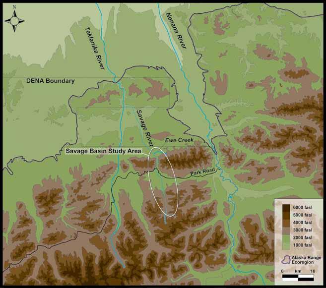
2 Alaska Park Science, Volume 12, Issue 1 Prehistoric Hunter-Gatherers in the Savage River Uplands, Denali National Park and Preserve By John Blong Took a trip... down Savage River Trail. That trail is a bear. (Davis 1980) In retrospect, I should have heeded NPS archaeologist Craig Davis words when planning our backcountry trip north along the Savage River Trail through the steep-sided Savage canyon in Denali National Park and Preserve (Denali) (Figure 1). Our destination was the confluence of the Savage River and Ewe Creek (Figure 2), where we camped for one week and excavated three archaeological sites. The trail was difficult, but the chilly wet weather and one-week worth of camping and archaeological excavation equipment on our backs made it even more so. In the end our trip proved worthwhile, and we collected important information on prehistoric hunter-gatherer activity in Denali. Our research in the Savage River basin is part of an ongoing study investigating how prehistoric huntergatherers lived and hunted in the mountainous uplands of the central Alaska Range, from earliest colonization at the end of the last ice age to less than 1,000 years ago. Emerging archaeological evidence suggests that upland landscapes of central Alaska were seasonally important to early humans (Holmes et al. 2010, Wygal 2010). When and how humans adapted to this landscape is unknown. Research also suggests prehistoric hunters Figure 1. Dall sheep on the Savage River Trail. Photograph courtesy of Heather Smith Figure 2. (Map) Savage Basin study area in the Alaska Range Ecoregion. adjusted their hunting technology to target caribou and sheep in the uplands, taking advantage of abundant tool-stone (stone suitable for tool-making) to fashion bifacially worked stone projectile points instead of the osseous inset-microblade projectile points preferred for lowland hunting (Potter 2011, Wygal 2010). Assessing these hypotheses is difficult because the majority of well-documented archaeological sites in central Alaska are located in the lowlands of the Nenana and Tanana river valleys, whereas in the uplands of the central Alaska Range, few prehistoric sites have been fully documented. The Savage River project was part of our effort to improve our knowledge of upland activities. Our research asks: When did humans first begin targeting resources in the uplands, and what was the environmental context of this use? How did the environment and use of upland resources change over time? How did use of upland resources influence stone tool manufacture, especially bifacial projectile versus inset-microblade weapons? The Savage River basin is within the upland Alaska Range Ecoregion (Figure 2), consisting of rugged mountain ridges and valleys and dwarf-scrub vegetation communities (Nowacki et al. 2001), and as such is ideal for studying prehistoric hunter-gatherer upland adaptations. In addition, there are significant park management interests in the Savage basin. More than 400,000 visitors visited the park in 2011 (DENA 2012 Fact Sheet); the Savage basin is highly impacted by this traffic and an important place for park managers to protect cultural resources. Given both research and management interests, the Savage River uplands project was developed with three goals in mind: (1) relocate and update Denali records on nine prehistoric archaeological sites in the upper Savage basin near the Park Road; (2) systematically survey the upper Savage basin for unrecorded archaeological sites; and (3) evaluate the condition and significance of three sites at the confluence of the Savage River and Ewe Creek. History of Archaeological Research in the Savage Basin A portion of this project retraced the steps of scientists responsible for the earliest archaeological discoveries in the park. In 1961, Dr. Frederick Hadleigh-West conducted the first extensive archaeological excavations (in what was then known as Mt. McKinley National Park) at the Teklanika West and Teklanika East sites. The discovery of prehistoric archaeological materials in close proximity to the Park Road moved the NPS to enlist Dr. H. Morris Morgan and Dr. Adan E. Treganza to undertake the first planned surveys of park archaeological resources in 1963 and Their efforts resulted in the discovery of 16 archaeological sites, including five located in the upper Savage basin. In 1980, NPS archaeologist Craig Davis revisited sections of Morgan and Treganza s survey routes to update cultural resource records, and located three more sites in the upper Savage basin (Griffin 1990). Treganza also targeted the Ewe Creek drainage area as a probable location for prehistoric hunter-gatherer activity based on information provided by Dr. Aldoph Murie, the pioneering naturalist, who observed a mineral outcrop (or lick) frequented by large game. Treganza surveyed the drainage, but found no significant 21

3 Prehistoric Hunter-Gatherers in the Savage River Uplands, Denali National Park and Preserve Figure 3. Typical elevated landform in the upper Savage basin covered in our survey. Landforms like this often had exposed archaeological material lying on the surface. archaeological material, and it was not until 1989 that an NPS survey team located three prehistoric sites along a high terrace overlooking the mineral lick (Lynch 1996). This research served as the foundation upon which we built our research project in the Savage basin Research In summer 2010, archaeologists from the Center for the Study of the First Americans at Texas A&M University conducted archaeological survey and excavation in the Savage River basin. In the upper Savage basin, we located previously recorded sites using coordinates and maps from Denali site files and identified landforms likely to have exposed archaeological material using topographic maps and infrared satellite images (Figure 3). Archaeological survey consisted of walking exposed surfaces and flagging artifacts, then recording GPS points and tool manufacturing data for each artifact (Figures 4-5). Detailed observations were recorded on the setting, condition, and potential significance of each site. Our 2010 Photograph courtesy of John Blong survey located four of nine previously recorded sites and six previously unrecorded sites, and we recorded information on a total of 77 stone artifacts, including 59 pieces of flaking debris and 18 flaked stone cores and tools. At Ewe Creek we used a total station survey device to record detailed provenience information before collecting surface artifacts at three sites (Figure 6). We excavated three 1m 2 test units to search for buried, datable artifact deposits and evaluate the significance of these sites. Our excavations established that there were two paleosols, (dark horizons representing a buried former ground surface), containing flaking debris (Figure 7). The lowest paleosol contained stone artifacts buried with charcoal wood dated to 4,150±40 radiocarbon years ago, or approximately 4,680 calendar years ago (cal BP). At the Ewe Creek sites we collected 53 stone artifacts, including 39 pieces of flaking debris and eight tools from surface contexts, and six pieces of flaking debris from subsurface contexts. Tool Manufacture A detailed study of the stone artifacts from the Savage basin indicates that a wide range of stone tool manufacturing activities occurred at these sites, primarily geared towards manufacturing tools from previously prepared stone blanks, as well as re-sharpening existing tools. Stone artifacts from the study area are primarily made of chert, an easily worked stone available from streambeds and gravel bars in the park, indicating that prehistoric hunters were obtaining quality rock from nearby drainages in the basin. The presence of stone projectile points, some of which had fractured upon impact, suggests that hunting was an important activity, but the presence of scraping and cutting tools suggests that carcass and hide processing also may have occurred at these sites (Figure 8-9). The small assemblages from the study area suggest short-term occupations: probably hunting camps, where prehistoric toolmakers primarily manufactured bifacially worked stone projectile points. 22


4 Alaska Park Science, Volume 12, Issue 1 Figure 4. CSFA archaeologists Angela Gore and Tom Jennings scour the exposed ground surface for artifacts in the upper Savage basin. Photograph courtesy of John Blong Photograph courtesy of Tom Jennings Figure 5. CSFA archaeologists John Blong and Tom Jennings collect information on stone artifacts lying on the surface in the upper Savage basin. Photograph courtesy of Angela Gore Photograph courtesy of John Blong Figure 6. CSFA archaeologists John Blong and Heather Smith collect detailed provenience information on surface artifacts at Ewe Creek. Figure 7. Sediment profile from 1 m2 test unit at Ewe Creek showing (a) paleosol containing cultural material, (b) paleosol containing cultural material and charcoal radiocarbon dated to 4,150 ±40 14C BP (4,680 calbp). 23
 has a breakage pattern typical of a projectile point that fractured upon impact. Figure 9.")

5 Prehistoric Hunter-Gatherers in the Savage River Uplands, Denali National Park and Preserve Figure 8. Bifacially worked stone projectile tips recovered at Ewe Creek. Artifact (b) has a breakage pattern typical of a projectile point that fractured upon impact. Figure 9. Stone artifacts recovered from Ewe Creek: (a) stone scraping tool likely used for carcass or hide processing, (b) bifacially worked stone projectile point base. Photograph courtesy of John Blong Photograph courtesy of John Blong Temporal Span of Uplands Occupation Archaeologists are most interested in artifacts that have been excavated from buried, datable contexts, because they often represent a discrete time period and therefore have more meaning to our understanding of prehistory. Unfortunately, most of the artifacts analyzed for this project were from surface contexts, and could potentially represent thousands of years of human activity. We recovered two lanceolate projectile point fragments, but this type of projectile point is found in assemblages dating from the Pleistocene through the late Holocene, and is often not useful as a chronological marker (Holmes et al. 2008). The buried artifacts from the Ewe Creek sites suggest that hunters occupied the study area as early as 4,680 cal BP, and the surface assemblages probably represent several occupations dating to this time period and younger, indicating that the uplands played an important role in huntergatherer lifeways in the middle and late Holocene. Park Management We had limited success revisiting previously recorded sites in the upper Savage basin. These sites could have been ephemeral occupations represented by the few artifacts that were collected in the original investigations, or cultural material may have been lost to erosion. A third possibility is that visitors disturbed or collected cultural material at these sites; all five of the unsuccessfully relocated sites are within a 30-minute hike from the Park Road. These results indicate how important it is to document archaeological sites before they are lost. Archaeological survey resulted in the discovery of five previously unrecorded sites, suggesting the future potential for locating additional unrecorded archaeological sites. The Ewe Creek sites are of particular significance because they have buried, datable cultural material in an unique setting adjacent to a mineral lick, and the age of the lowest component is a time not well represented in the prehistory of the region. This project utilized field notes, GPS, 24
6 Alaska Park Science, Volume 12, Issue 1 and digital photography to significantly upgrade Denali site record forms and document new sites in the Savage basin, equipping park managers with the information necessary to make cultural resource management decisions. Summary Our 2010 field research program in the Savage basin met the three goals outlined in our research design. We successfully updated existing archaeological site records, located unrecorded sites, and excavated and dated artifacts from Ewe Creek, providing park managers with the information necessary to protect important cultural resources. We also worked towards our two long-term research objectives: documenting prehistoric huntergatherer activity in the mountainous uplands of the central Alaska Range, and explaining the factors that influence prehistoric stone-tool manufacture. The data collected during this project suggests that by the middle Holocene, prehistoric people were using the uplands of the Savage basin for short-term hunting needs and collecting tool-stone from nearby drainages to produce bifacially worked projectile points. Future research will continue archaeological survey and excavation in the uplands of the Alaska Range to improve our knowledge of prehistoric use of these landscapes. More information about this project is available ( Acknowledgements This research was funded by the Center for the Study of the First Americans Roy J. Shlemon Student Field Geoarchaeology Award and the Murie Science and Learning Center Discover Denali Research Fellowship. This project would not have been possible without the efforts of the 2010 field crew: Tom Jennings, Heather Smith, and Angela Gore. REFERENCES Davis, C Archaeological Field Notes. On file at the National Park Service, Alaska Regional Office. Anchorage, Alaska. Griffin, K An Overview and Assessment of Archeological Resources, Denali National Park and Preserve, Alaska. Research/Resources Management Report AR-16. Department of Interior, National Park Service, Alaska Regional Office. Anchorage, Alaska. Holmes, C.E., B.A. Potter, J.D. Reuther, O.K. Mason, R.M. Thorson, and P. Bowers Geological and Cultural Context of the Nogahabara I Site. American Antiquity 73(4): Holmes, C.E., J.D. Reuther, and P. Bowers The Eroadaway Site: Early Holocene Lithic Technological Variability in the Central Alaska Range. Paper presented at the 37th Annual Meeting of the Alaska Anthropological Association. Anchorage, Alaska. Lynch, A.J Archeological Investigations of Five Remote Tracts of Land within Denali National Park and Preserve, Alaska: 1988, Department of the Interior, National Park Service, Alaska System Support Office, Division of Cultural Resources. Anchorage, Alaska. Nowacki. G.J., P. Spencer, M. Fleming, T. Brock, and T. Jorgenson Ecoregions of Alaska and Neighboring Territories. U.S. Geological Survey Open-File Report Potter, B.A Late Pleistocene and Early Holocene Assemblage Variability in Central Alaska. In From the Yenisei to the Yukon: Interpreting Lithic Assemblage Variability in Late Pleistocene/Early Holocene Beringia, edited by Ted Goebel and Ian Buvit, pp Texas A&M University Press. College Station, Texas. Wygal, B.T Prehistoric Upland Tool Production in the Central Alaska Range. Alaska Journal of Anthropology 8(1):
Table 9. FAI accession log
 Table 9. FAI-02045 accession log UA Accession # FS # Depth (cm BS) Artifact Type n= Material Color UA2010-187-0001 1 5-10 utilized flake 1 basalt black UA2010-187-0002 2 5-10 flake 1 chert black UA2010-187-0003
DIRT ROADS, ANCIENT LANDSCAPES, AND EARLY SITES
 DIRT ROADS, ANCIENT LANDSCAPES, AND EARLY SITES JOAN E. BRANDOFF-KERR LOS PADRES NATIONAL FOREST (RETIRED) DAN REEVES ROCK ART DOCUMENTATION GROUP, SANTA BARBARA, CALIFORNIA Early populations in the Santa
SUMMARY OF 2015 RESEARCH OF THE SCOTTIE CREEK BORDERLANDS CULTURE HISTORY PROJECT
 SUMMARY OF 2015 RESEARCH OF THE SCOTTIE CREEK BORDERLANDS CULTURE HISTORY PROJECT Norman Alexander Easton Field research in 2015 began in early June and continued to late August. At the projects based
RE: End of Field Letter for the Proposed Milton Mears Farm Road Solar Project, Milton, Chittenden County, Vermont
 October 10, 2017 Kirk Shields Green Mountain Power 163 Acorn Lane Colchester, VT 05446 RE: End of Field Letter for the Proposed Milton Mears Farm Road Solar Project, Milton, Chittenden County, Vermont
Kansas Archaeology Month
 Activities for Discovering Prehistoric Trails TIME: 45 min. Kansas Archaeology Month Discovering Prehistoric Trails This lesson is divided into four sections: instructional goals, advanced preparation,
Figure 66. FAI site overview.
 Figure 66. FAI-02246 site overview. FAI-02247 Latitude: Longitude: UTM: Determination of Eligibility: Not evaluated FAI-02247 is located on a high point where the northern branch of the Blair Lakes ridge
Origins of the First Californians
 Setting the Stage for the Peopling of the Americas Origins of the First Californians John R. Johnson Anthropology 131CA Mal ta Peopling of Siberia was episodic between 35,000 and 15,000 years ago. Middle
Selected Archeological Terms
 Page 1 of 6 Selected Archeological Terms Links General Reference Bibliographies Glossaries Terms A b C D E F G H i j k l M N O P q R S T U V w x y z ADAPTATION: The process of change to better conform
Stratigraphy Layers of Time in the Earth by Carol Schlenk
 Subject: Science, Social Studies Grade level: 11-12 Stratigraphy Layers of Time in the Earth by Carol Schlenk Rationale: This lesson introduces students to the concept of stratification as a historical
Erosional Features. What processes shaped this landscape?
 Have you ever looked at the land around you and wondered what processes shaped what you see? Perhaps you see mountains, valleys, rivers, or canyons. Do you know how long these geologic features have been
EROSIONAL FEATURES. reflect
 reflect Have you ever looked at the land around you and wondered what processes shaped what you see? Perhaps you see mountains, valleys, rivers, or canyons. Do you know how long these geologic features
Archaeological Predictive Modeling within the context of Paleo-river Terraces in the City of Prince George
 Archaeological Predictive Modeling within the context of Paleo-river Terraces in the City of Prince George Background The documented pre-contact archaeological record of the Interior Plateau of B.C. is
December 13, Kirk Shields Green Mountain Power 163 Acorn Lane Colchester, VT 05446
 December 13, 2017 Kirk Shields Green Mountain Power 163 Acorn Lane Colchester, VT 05446 RE: End of Field Letter for Archaeological Phase II Site Evaluation at Site VT-CH-1218 within the Proposed Milton
Prehistoric Clay Sources: A Forensic Exercise in Geoarchaeology
 Prehistoric Clay Sources: A Forensic Exercise in Geoarchaeology Lynn Ketterhagen Faculty Sponsor: Dean Wilder, Department of Geography and Earth Science ABSTRACT The prehistoric Oneota culture of the Upper
AN ARCHAEOLOGICAL SURVEY FOR THE DCP MIDSTREAM THREE RIVERS PLANT TO CGP 51 PROJECT IN LIVE OAK COUNTY, TEXAS
 AN ARCHAEOLOGICAL SURVEY FOR THE DCP MIDSTREAM THREE RIVERS PLANT TO CGP 51 PROJECT IN LIVE OAK COUNTY, TEXAS By William E. Moore Brazos Valley Research Associates Contract Report Number 251 2011 AN ARCHAEOLOGICAL
Archaeological Excavations at Pie Creek and Tule Valley Shelters, Elko County, Nevada
 NEVADA DEPARTMENT OF CULTURAL AFFAIRS DIVISION OF MUSUEUMS AND HISTORY SUB Hamburg B/89960 NEVADA STATE MUSEUM ANTHROPOLOGICAL PAPERS NUMBER 25 Archaeological Excavations at Pie Creek and Tule Valley Shelters,
Starting at Rock Bottom: A Peculiar Central Texas PreClovis Culture
 Starting at Rock Bottom: A Peculiar Central Texas PreClovis Culture Background Brushy Creek grades, overall, west-northwest (WNW) to east-southeast (ESE) through the easternmost portions of the central
Yukon Mineral Exploration Best Management Practices for Heritage Resources April 2010 Edition 1
 Tourism & Culture Heritage Resources Tourism & Culture Heritage Resources Yukon Mineral Exploration Best Management Practices for Heritage Resources April 2010 Edition 1 DISCLAIMER Nothing in the Yukon
AN ARCHAEOLOGICAL SURVEY FOR THE EASTHAM STATE PRISON FARM UNIT PROJECT IN HOUSTON COUNTY TEXAS
 AN ARCHAEOLOGICAL SURVEY FOR THE EASTHAM STATE PRISON FARM UNIT PROJECT IN HOUSTON COUNTY TEXAS Antiquities Permit 5693 By William E. Moore and Edward P. Baxter Brazos Valley Research Associates Contract
THE CROOKS GAP HOUSEPIT SITE AND OTHER NEARBY MID-HOLOCENE HOUSEPITS
 Volume 56(1 ), Spring 2012 The Wyoming Archaeologist THE CROOKS GAP HOUSEPIT SITE AND OTHER NEARBY MID-HOLOCENE HOUSEPITS by Craig S. Smith Marcia Peterson INTRODUCTION This article summarizes excavation
Natural hazards in Glenorchy Summary Report May 2010
 Natural hazards in Glenorchy Summary Report May 2010 Contents Glenorchy s hazardscape Environment setting Flood hazard Earthquakes and seismic hazards Hazards Mass movement Summary Glossary Introduction
Archaeology at Meadowcroft Rockshelter GigaPan Lessons
 Archaeology at Meadowcroft Rockshelter GigaPan Lessons An exploration of archaeological methodology at Meadowcroft Rockshelter Summary: This activity guides learners through an exploration of the archaeological
Archaeological Survey and Evaluation at 8954 El Dorado Parkway, El Cajon, San Diego County, California
 April 16, 2013 Ms. Andrea Bitterling Helix Environmental Planning, Inc. 7578 El Cajon Blvd., Suite 200 El Cajon, California 91942 Re: Archaeological Survey and Evaluation at 8954 El Dorado Parkway, El
Weathering and Erosion
 Have you ever looked at the land around you and wondered how it was shaped? The geologic features that help define the world are still being shaped by the natural processes of weathering, erosion, and
Texas Prehistoric Archeology. TPWD Cultural Resources Coordinator (a.k.a. Archeologist)
") Texas Prehistoric Archeology TPWD Cultural Resources Coordinator (a.k.a. Archeologist) Prehistory Definition Prehistory is that time when man first came to North America (~12,000 BP [years before present])
Texas Prehistoric Archeology TPWD Cultural Resources Coordinator (a.k.a. Archeologist) Prehistory Definition Prehistory is that time when man first came to North America (~12,000 BP [years before present])
Archaeological Glossary
 Archaeological Glossary analysis: the stage of archaeological research that involves the description and classification of archaeological data. anthropology: the study of humans, including the variety
BISTI / DE-NA-ZIN WILDERNESS
 BISTI / DE-NA-ZIN WILDERNESS Activities: Facilities: Season / Hours: Description: Hiking and photography. No electrical hookups, water, or restrooms are available. Open year-round. The Bisti/De-Na-Zin
Earth and Space: Topographic Maps Satellite Images
 Earth and Space: Topographic Maps Satellite Images Earth and Space: Formative Assessment Activities for Earth and Space Topographic Maps Satellite Images Teacher Pages Purpose The purpose of this station
Vegetation and Wildlife Habitat Mapping Study in the Upper and Middle Susitna Basin Study Plan Section 11.5
 (FERC No. 14241) Vegetation and Wildlife Habitat Mapping Study in the Upper and Middle Susitna Basin Study Plan Section 11.5 Initial Study Report Part C: Executive Summary and Section 7 Prepared for Prepared
David R. Yesner Department of Anthropology, University of Alaska Anchorage
 l a t e p l e i s t o c e n e /e a r ly h o l o c e n e s i t e s t r u c t u r e in b e r i ng i a: a case study from the broken mammoth site, interior alaska Kathryn E. Krasinski Department of Anthropology,
PW Parkway ES Prince William County, Virginia WSSI #
 PW Parkway ES Prince William County, Virginia WSSI #15.3 Cultural Resources Site Assessment November 15 Prepared for: Prince William County Public Schools P.O. Box 39 Manassas, Virginia 1 Prepared by:
THE TWO MOST SIGNIFICANT ARCHEOLOGICAL SITES IN KERR COUNTY, TEXAS ARE THE GATLIN SITE AND THE BEARING SINK HOLE SITE.
 WHAT ARE THE MOST IMPORTANT ARCHEOLOGY SITES IN KERR COUNTY? By Steve Stoutamire THE TWO MOST SIGNIFICANT ARCHEOLOGICAL SITES IN KERR COUNTY, TEXAS ARE THE GATLIN SITE AND THE BEARING SINK HOLE SITE. Map
interpret archaeological strata using the law of superposition; apply cross-dating to determine the age of other artifacts.
 Grade 8: Standardized Task Competency Goal 5: The learner will conduct investigations and utilize appropriate technologies and information systems to build an understanding of evidence of evolution in
Additional Testing for Padre Dam Eastern Service Area Secondary Connection- Alternative Site Location, San Diego County, California
 Mark Niemiec Padre Dam Municipal Water District P.O. Box 719003 9300 Fanita Parkway Santee, California 92072 Re: Additional Testing for Padre Dam Eastern Service Area Secondary Connection- Alternative
Placer Potential Map. Dawson L and U se P lan. Jeffrey Bond. Yukon Geological Survey
 Placer Potential Map Dawson L and U se P lan By Jeffrey Bond Yukon Geological Survey Dawson Land Use Plan Placer Potential Map 1.0 Introduction Placer mining has been an important economic driver within
Midterm Review. Nata/Lee
 Name: 1. Which statement best supports the theory that all the continents were once a single landmass? (1) Rocks of the ocean ridges are older than those of the adjacent sea floor. (2) Rock and fossil
The Upper Paleolithic Longwangcan Site at Yichuan in Shaanxi
 The Upper Paleolithic Longwangcan Site at Yichuan in Shaanxi The Institute of Archaeology, Chinese Academy of Social Sciences Shaanxi Provincial Institute of Archaeology Key words: Longwangcan site; microliths;
4.11 CULTURAL RESOURCES
 4.11 CULTURAL RESOURCES 4.11 CULTURAL RESOURCES This section summarizes the cultural resources of. Information reviewed for the summary includes the General Plan, published reports on archaeological research
The subject paper is being submitted for approval for publication in the annual volume entitled Geological Survey Research.
 Water Resources Division 345 Middlefield Road Menlo Park, California January 12, 1965 Memorandum To: Mr. Frank E. Clark, Chief, General Hydrology Branch Thru: Area Hydrologist PCA From: Valmore C. LaMarche
MOR FOSSILS TEACHERS. Making a Fossil Activity Overview BIG IDEA
 Making a Fossil Activity Overview BIG IDEA OBJECTIVE BACKGROUND Not every organism that died, including dinosaurs, left behind a fossil. Explore fossilization with this activity. Students will follow a
SECOND HOMEWORK ASSIGNMENT Absolute and Relative Dating Methods
 Tulane University Chris Rodning NAME INTRODUCTION TO ARCHAEOLOGY ANTH 334 F2008 SCORE of 40 points SECOND HOMEWORK ASSIGNMENT Absolute and Relative Dating Methods Answer the following questions about dating
Archaeological Survey and Assessment of Four Wastewater Interceptor Routes in Garner, Wake Co., N.C. (EPA C )
") Archaeological Survey and Assessment of Four Wastewater Interceptor Routes in Garner, Wake Co., N.C. (EPA C370623-02) By H. Trawick \vard R. P. Stephen Davis Prepared by the Research Laboratories of Anthropology
Archaeological Survey and Assessment of Four Wastewater Interceptor Routes in Garner, Wake Co., N.C. (EPA C370623-02) By H. Trawick \vard R. P. Stephen Davis Prepared by the Research Laboratories of Anthropology
Unit 7.2 W.E.D. & Topography Test
 Name: Score: Unit 7.2 W.E.D. & Topography Test 1. 2. 3. 4. 5. 6. 7. 8. 9. 10. 11. 12. 13. 14. 15. 16. 17. 18. 19. 20. 21. 22. 23. 24. 25. 1. The formation of mountains is due mainly to while the destruction
Notes and Summary pages:
 Topographic Mapping 8.9C Interpret topographical maps and satellite views to identify land and erosional features and predict how these shapes may be reshaped by weathering ATL Skills: Communication taking
Clough Award 2017 Katmai and the Valley of Ten Thousand Smokes
 Clough Award 2017 Katmai and the Valley of Ten Thousand Smokes In June 2017, Clough Award funding allowed me to participate in the International Volcanology Summer School, organised by University of Alaska
Pastoralists and GIS: Predictive Modeling and Campsite Location in Beidha, Southern Jordan
 Pastoralists and GIS: Predictive Modeling and Campsite Location in Beidha, Southern Jordan Outline Predictive Modeling: Why? Why Beidha? Modeling Parameters: What works, What Doesn't. The Model. The Next
APPENDIX G GLOSSARY. Mn/DOT/WR-0200
 APPENDIX G GLOSSARY Mn/DOT/WR-0200 Alluvial - comprised of clay, silt, sand, gravel, and/or other detritus deposited by water. Usually refers to accretionary overbank, floodplain or levee deposits. Biomantling
Plate 51. Site 035. Collection of remains. Scale is in cm. Plate 50. Site 034. Collection of remains. Scale is in cm
 Plate 48. Site 033. View facing north west Plate 49. Site 034. View facing north Pottery Pottery Ostrich eggshell Plate 50. Site 034. Collection of remains. Scale is in cm Plate 51. Site 035. Collection
ORIENTEERING. The challenge is to use the map to decide the best route to complete the course in the quickest time. Orienteering Map. Compass.
 ORIENTEERING Orienteering is similar to a cross-country race but you navigate using a map instead of following a set course. It is an outdoor sport where competitors navigate their own way, you can run,
DATING HOW OLD IS THIS THING?
 DATING HOW OLD IS THIS THING? WHY? u CROSS-CULTURAL COMPARISON v UNDERSTANDING DEVELOPMENT AND CHANGE OF A PARTICULAR GROUP OR CULTURE w UNDERSTANDING SITE FORMATION PROCESSES x UNDERSTANDING REGIONAL
The Cassiar Mountains
 The Cassiar Mountains Introduction Topography Dease Plateau Dease Lake, BC Stikine Ranges Eve Cone Mount Edziza Provincial Park Mount Ash, BC 2 125m Ketchika Ranges Muskwa- Ketchika Management Area Sifton
Vantage/Columbia Basin Field Trip
 Geology 152 Name Vantage/Columbia Basin Field Trip The primary goal of this course is to help you see the Earth from a different perspective a geological one. To accomplish this goal you will be expected
MINNESOTA DEEP TEST PROTOCOL PROJECT
 MINNESOTA DEEP TEST PROTOCOL PROJECT Mn/DOT Agreement No. 85878 OSA License No. 04-030 Authorized and Sponsored by: MINNESOTA DEPARTMENT OF TRANSPORTATION FEDERAL HIGHWAY ADMINISTRATION Prepared by COMMONWEALTH
Module/Unit: Landforms Grade Level: Fifth
 Module/Unit: Landforms Grade Level: Fifth PA Academic Standards for Science and Technology and Environment and Ecology: 3.1.7.B Describe the use of models as an application or scientific or technological
Glacial Geology of Moose Point State Park, ME
 Geologic Site of the Month May, 2013 Glacial Geology of Moose Point State Park, Maine 44 o 25 59.18"N, 68 o 56 37.11"W Text and photos by Woodrow B. Thompson, Department of Agriculture, Conservation &
CHAPTER 5 LATE ARCHAIC LITHIC TECHNOLOGY AND LAND USE WITHIN THE GARDINER BASIN, UPPER YELLOWSTONE RIVER, MONTANA/WYOMING
 CHAPTER 5 LATE ARCHAIC LITHIC TECHNOLOGY AND LAND USE WITHIN THE GARDINER BASIN, UPPER YELLOWSTONE RIVER, MONTANA/WYOMING excavated 24YE14 in Gardiner, Montana, another Late Archaic site in the study area.
Hiking the Bold Coast, Cutler, Maine
 Maine Geologic Facts and Localities June, 2010 Hiking the Bold Coast, Cutler, Maine 44 o 39 36.34 N, 67 o 12 46.99 W Text by Robert A. Johnston, Department of Agriculture, Conservation & Forestry 1 Map
ARCHAEOLOGICAL SURVEY OF BANDERA CITY PARK, BANDERA COUNTY, TEXAS
 ARCHAEOLOGICAL SURVEY OF BANDERA CITY PARK, BANDERA COUNTY, TEXAS Ronald W. Burkett I / Center for Archaeological Research The University of Texas at San Antonio Archaeological Survey Report, No. 183 1989
Prehistory and History of Squaw Creek, Powder River Basin, Wyoming
 Prehistory and History of Squaw Creek, Powder River Basin, Wyoming Mavis Greer, Ph.D. and John Greer, Ph.D. Paper Presented at the 53 rd Annual Meeting of the Wyoming Archaeological Society Cheyenne, Wyoming
The Upper Palaeolithic of North China Chaisi Locality 7701
 The Upper Palaeolithic of North China Chaisi Locality 7701 Tang Chung Centre for Chinese Archaeology and Art The Chinese University of Hong Kong 1 LOCATION The site of Chaisi is located at the bank of
Chapter 5 LiDAR Survey and Analysis in
 Chapter 5 LiDAR Survey and Analysis in 2010-2011 Christopher Fennell A surveyor s plat and town plan filed in 1836 set out an intended grid of blocks, lots, alleys, and streets for New Philadelphia. Geophysical,
The Little Clovis Point that Wasn t
 Manitoba Archaeological Society The projectile point illustrated in Figure 1 was surface-found at FaMi-10 in the Upper Swan River valley of Manitoba (Fig. 2) in the 1960s. It is made of Swan River Chert,
Yukon Wilderness Tourism Best Management Practices for Heritage Resources February 2009 Edition 1
 Tourism & Culture Heritage Resources Tourism & Culture Heritage Resources Yukon Wilderness Tourism Best Management Practices for Heritage Resources February 2009 Edition 1 DISCLAIMER Nothing in the Yukon
Waterbury Dam Disturbance Mike Fitzgerald Devin Rowland
 Waterbury Dam Disturbance Mike Fitzgerald Devin Rowland Abstract The Waterbury Dam was completed in October 1938 as a method of flood control in the Winooski Valley. The construction began in April1935
Update on Archaeological Resources Assessment for Phase 1 Dredge Areas
 Update on Archaeological Resources Assessment for Phase 1 Dredge Areas Prepared by URS Corp for General Electric Presented by John Vetter, USEPA CAG Meeting December 8, 2005 1 Presentation Outline Overview
Social Studies - Read the article "The Earliest Americans" and complete the Build Your Map Skills page and Extinct Animals of North America page.
 Day 2 Social Studies - Read the article "" and complete the Build Your Map Skills page and Extinct Animals of North America page. Language Arts - Draw a self-portrait of yourself in the center of a piece
Name. Designed and Produced for the Orleans County Historical Society by Andrew R. Beaupré, RPA
 Name Archaeology! Archeology! What is Archaeology? Archaeology is the scientific study of people of the past by studying the places people lived, the objects they used, and traces in the soil left by human
Bestwood 1: a newly discovered Earlier Stone Age living surface near Kathu, Northern Cape Province, South Africa
 Project Gallery Antiquity Volume 086 Issue 331 March 2012 Bestwood 1: a newly discovered Earlier Stone Age living surface near Kathu, Northern Cape Province, South Africa Michael Chazan, Jayne Wilkins,
SETTLEMENT. Student exercises. The Kuril Biocomplexity Project:
 SETTLEMENT Student exercises Table of Content Vocabulary... 67 Background Information... 69 Introduction... 7 Part 1... 71 Part 2... 8 76 Vocabulary Deposit: Sediment put down on the earth surface in the
Sacred Lands File & Native American Contacts List Request
 Sacred Lands File & Native American Contacts List Request NATIVE AMERICAN HERITAGE COMMISSION 915 Capitol Mall, RM 364 Sacramento, CA 95814 (916) 653-4082 (916) 657-5390 Fax nahc@pacbell.net Information
Lapita and Later Archaeology of the Malolo and Mamanuca Islands, Fiji
 Journal of Island & Coastal Archaeology, 2:245 250, 2007 Copyright 2007 Taylor & Francis Group, LLC ISSN: 1556-4894 print / 1556-1828 online DOI:10.1080/15564890701622896 Lapita and Later Archaeology of
Topographic Maps and Mount Rainier
 Topographic Maps and Mount Rainier 50 60 80 70 Learner Objectives: Students will: Read and understand map explanations, including the name, date and origin of the map, scale and contour intervals Understand
Physiographic Provinces (West, Ch. 13)
") Geology 229 Engineering Geology Lecture 13 Physiographic Provinces (West, Ch. 13) The definition of the term Physiography Physiography (n.) The science which treats of the earth's exterior physical features,
Geology 229 Engineering Geology Lecture 13 Physiographic Provinces (West, Ch. 13) The definition of the term Physiography Physiography (n.) The science which treats of the earth's exterior physical features,
2014 Arizona State University, School of Geographical Sciences and Urban Planning Lounsbury Travel Award. $350
 Heather A. Fischer Arizona State University School of Geographical Sciences and Urban Planning P.O. Box 875302 Tempe, AZ 85287-5302 (801) 870-3365 heather.fischer@asu.edu https://sites.google.com/a/asu.edu/heatherafischer/
Timing and magnitude of late Pleistocene and Holocene glaciations in Yosemite National Park
 National Park Service U.S. Department of the Interior Yosemite National Park Timing and magnitude of late Pleistocene and Holocene glaciations in Yosemite National Park Greg Stock Yosemite National Park
Study Module for RIVER PROCESSES. Geo Lab at Nordland National Park Centre. HANDBOOK for TEACHERS
 Study Module for RIVER PROCESSES Geo Lab at Nordland National Park Centre HANDBOOK for TEACHERS Table of contents 1 Summary of module... 3 1.1 Level... 5 1.2 Objectives... 5 1.3 Curriculum links... 5 1.3.1
Elevations are in meters above mean sea level. Scale 1:2000
 12.001 LAB 7: TOPOGRAPHIC MAPS Due: Monday, April 11 PART I: CONTOURING AND PROFILES (20 PTS) 1. Contour this area map using a 5 meter contour interval. Remember some fundamental rules of contour lines,
5 Significance of Geomorphology to Cultural Resources
 5 Significance of Geomorphology to Cultural Resources Introduction Objectives The last and most important objective of this study was to determine the archaeological significance of the geomorphic features,
DRAFT
 A84536-22, A81184-3 Discovery of Human Remains On Site Lead Licensing and Environmental Assessment Archaeologist Manitoba Historic Resources Branch (HRB) RCMP STOP activities at location Step 6
The Ancient World. Chapter 1 The Beginnings of Human Society. What historical accomplishments is each civilization known for?
 Chapter 1 The Beginnings of Human Society Chapter 1-Guiding Questions: What historical accomplishments is each civilization known for? How did physical geography affect the growth of ancient civilizations
GEOL151 Fall 2016: Lab for Week #7 Drainage Basins: Following a River from Source to Sink
 GEOL151 Fall 2016: Lab for Week #7 Drainage Basins: Following a River from Source to Sink Overview As we enter the middle of the course, we move into more synthetic topics and strive to gain an understanding
New investigations at Shanidar Cave, Iraqi Kurdistan
 New investigations at Shanidar Cave, Iraqi Kurdistan Tim Reynolds, William Boismier, Lucy Farr, Chris Hunt, Dlshad Abdulmutalb & Graeme Barker Shanidar Cave (36º50 N, 44º13 E) in the Zagros Mountains of
Kara-Bom: new investigations of a Palaeolithic site in the Gorny Altai, Russia
 Kara-Bom: new investigations of a Palaeolithic site in the Gorny Altai, Russia Natalia E. Belousova 1,2,, Evgeny P. Rybin 1,2, Alexander Yu. Fedorchenko 1,2 &AntonA.Аnoykin 1,2 New archaeological investigations
Patterns of Recovery Outdoor Activity
 Mount St Helens National Volcanic Monument Teacher s Corner 2011 Gifford Pinchot National Forest USDA Forest Service Patterns of Recovery Outdoor Activity Time Commitment: Site: Location: 45 minutes to
MAPS AND THEIR CLASSIFICATION
 MAPPING MAPS AND THEIR CLASSIFICATION WHAT IS A MAP? A map is representation of the Earth's surface, showing how things are related to each other by distance, direction, and size. Maps are a way of showing
Appendix I-1: Archaeological Records Search
 Appendix I-1: Archaeological Records Search South Central Coastal Information Center California State University, Fullerton Department of Anthropology MH-426 800 North State College Boulevard Fullerton,
Living in a Watershed
 Living in a Watershed Department of Ecosystem Science and Ma... http://ecosystems.psu.edu/youth/sftrc/lesson-plans/water/k-5/watershed Department of Ecosystem Science and Management Youth Living in a Watershed
Your web browser (Safari 7) is out of date. For more security, comfort and the best experience on this site: Update your browser Ignore
 is out of date. For more security, comfort and the best experience on this site: Update your browser Ignore") Your web browser (Safari 7) is out of date. For more security, comfort and the best experience on this site: Update your browser Ignore DOGGERL AND - THE EU RO PE THAT WAS The British Isles were once neither
Your web browser (Safari 7) is out of date. For more security, comfort and the best experience on this site: Update your browser Ignore DOGGERL AND - THE EU RO PE THAT WAS The British Isles were once neither
STAAR Science Tutorial 40 TEK 8.9C: Topographic Maps & Erosional Landforms
 Name: Teacher: Pd. Date: STAAR Science Tutorial 40 TEK 8.9C: Topographic Maps & Erosional Landforms TEK 8.9C: Interpret topographic maps and satellite views to identify land and erosional features and
PHYSICAL GEOGRAPHY. By Brett Lucas
 PHYSICAL GEOGRAPHY By Brett Lucas FLUVIAL PROCESSES Fluvial Processes The Impact of Fluvial Processes on the Landscape Streams and Stream Systems Stream Channels Structural Relationships The Shaping and
PSI Paleo Sleuth Investigation Grades 4-8
 PSI Paleo Sleuth Investigation Grades 4-8 Paleo Sleuth Investigations, or PSI, includes four activities to be used in succession that focus around fossils in Nebraska and the Ashfall Fossil Beds State
Changes in Texas Ecoregions
 Comment On Lesson Changes in Texas Ecoregions The state of Texas can be divided into 10 distinct areas based on unique combinations of vegetation, topography, landforms, wildlife, soil, rock, climate,
abrasion the rubbing, grinding, and bumping of rocks that cause physical weathering (SRB, IG)
") FOSS Soils, Rocks, and Landforms Module Glossary NGSS Edition 2019 abrasion the rubbing, grinding, and bumping of rocks that cause physical weathering (SRB, IG) acid a substance that geologists use to
FOSS Soils, Rocks, and Landforms Module Glossary NGSS Edition 2019 abrasion the rubbing, grinding, and bumping of rocks that cause physical weathering (SRB, IG) acid a substance that geologists use to
EQ: Discuss main geographic landforms of the U.S. & Canada and examine varied landforms in relation to their lifestyles.
 EQ: Discuss main geographic landforms of the U.S. & Canada and examine varied landforms in relation to their lifestyles. Places & Terms for Discussion Appalachian Mountains Great Plains Canadian Shield
SUPPLEMENTAL MATERIAL
 SUPPLEMENTAL MATERIAL DESCRIPTIONS OF OTHER STRATIGRAPHIC SECTIONS Cherry Creek In its middle reaches, Cherry Creek meanders between three paired terraces within a narrow bedrock valley. The highest is
Discovery Site of Sudbury Mining Camp, Sudbury
 Birthplace of a World Famous Mining District Coordinates (46.52110 o 81.5337 o ) Aerial view of Murray Mine open pit prior to flooding. (Left) Roadside historic marker. It all started here. In 1883, nickel-copper
Wednesday October 22, VIII The Spread of Homo sapiens sapiens E. Colonization of the New World IX Broad Spectrum Hunting and Gathering
 Wednesday October 22, 2014 VIII The Spread of Homo sapiens sapiens E. Colonization of the New World IX Broad Spectrum Hunting and Gathering 1-2 paragraph Summary On the Human Prehistory Part of the Film
ADDENDA #1 CONTRACT # C May 3, 2013 Page 1 of 1
 State of California Natural Resources Agency Edmund G. Brown Jr., Governor DEPARTMENT OF PARKS AND RECREATION Major General Anthony L. Jackson, USMC (Ret), Director ADDENDA #1 CONTRACT # C1247040 May 3,
The Geology of Sebago Lake State Park
 Maine Geologic Facts and Localities September, 2002 43 55 17.46 N, 70 34 13.07 W Text by Robert Johnston, Department of Agriculture, Conservation & Forestry 1 Map by Robert Johnston Introduction Sebago
Field Trip to Tempe Butte
 Synopsis Field Trip to Tempe Butte So far you have been identifying rocks and mapping their locations without actually going there. Now it is your chance to put it all together and see real rocks out in