Pastoralists and GIS: Predictive Modeling and Campsite Location in Beidha, Southern Jordan
|
|
|
- Amie Gray
- 5 years ago
- Views:
Transcription

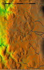
1 Pastoralists and GIS: Predictive Modeling and Campsite Location in Beidha, Southern Jordan
2 Outline Predictive Modeling: Why? Why Beidha? Modeling Parameters: What works, What Doesn't. The Model. The Next Steps for Predictive Modeling. Beidha Revisited (Site Formation Processes). Conclusions
3 Predictive Modeling and Near Eastern Nomadic Pastoralism Goats and sheep were fully domesticated by 9000 kya. Nomadic pastoralism was therefore a major social and economic strategy by at least the PPN whose participants were dynamically involved with their more settled neighbors. Why then do we know so little about these ancient pastoralists? Due to the nature of pastoralism, campsites are generally temporary and ephemeral. Therefore, the survey strategies employed to find more permanent agricultural sites are not effective. Survey methodologies utilized in the research of hunter-gatherer site are more useful, but even these do not take the interdependence of pastoralists and their herd animals in to account
4 Predictive Modeling and Near Eastern Nomadic Pastoralism Predictive models have been used successfuly in other types of archaeology for several decades, but have never been employed in the archaeology of nomadic pastoralists. Modern GIS combines advanced terrrain simulation and robust geo-statistical abilities with high powered computing to provide a platform for types of predictive modeling heretofore thought functionally impossible. Multivariate analysis of ecological, cultural, and geographic variables of nomadic campsite location can be cross-tabulated with known campsites to create a unique model.
5 Predictive Modeling and Near Eastern Nomadic Pastoralism These models can be tuned both in geographic and cultural scope, and provide multiple types of information useful to archaeologists. Not only can they tell us where sites are located, they can tell us exactly why these types of site are located where they are.
6

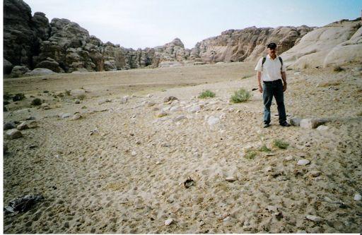
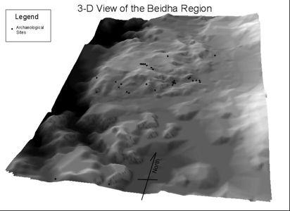
7 Why Beidha? Pastoralism in Beidha
8 Pastoralism in Beidha Why Beidha? Surveyed specifically for recent pastoral campsites in 1982 by Banning and Köhler- Rollefson and again in by Simms and Russell, and other travel 19 th and early 20 th century travellers visited the are and wrote about the pastoralists they encountered. Extensive ethnological and ethnoarchaeological data for the modern Bedouin of the region. Small in total area, but comprised of diverse ecological and geographic zones. Presents a living laboratory that has been studied ethnoarchaeologically for over two decades.


9 Upland Forested Wadis Lowland Alluvial Zones
10
11 Modeling Parameters What seems useful? The fallacy of water and pasture Purely ecological factors? Purely cultural factors? The right mix. Trial and error is the only way. What I used for the Beidha Model: Distance to Wadi bottoms as a proxy for water. Distance to ridge tops as a proxy for pasture and seasonality. Slope as a measure of water avoidance and ease of camping. Aspect as measure of wind and sun avoidance/seeking. Parameters tested and not used. Substrate type; Distance to shadows (Summer and Winter); Viewshed area and direction; Distance to the roads; Distance to the various geobotanical zones.


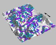
12 Summer Areas All Predicted Areas Winter Areas
13 The Future of Predictive Modeling More sophisticated environmental models. Larger scale, more realistic digital elevation models. More accurate environmental simulation using remotely sensed data and irradiation simulation.


14 Intensity of Solar Radiation Overall Ground Reflectance
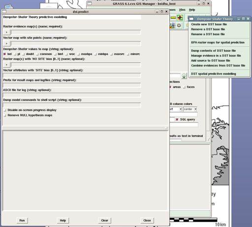
15 The Future of Predictive Modeling More sophisticated environmental models. Larger scale, more realistic digital elevation models. More accurate environmental simulation using remotely sensed data and irradiation simulation. More appropriate model building tools. Dempster Schafer Theory and Plugin for GRASS GIS
16
17 The Future of Predictive Modeling More sophisticated environmental models. Larger scale, more realistic digital elevation models. More accurate environmental simulation using remotely sensed data and irradiation simulation. More appropriate model building tools. Dempster Schafer Theory and Plugin for GRASS GIS Paleoenvironmental reconstruction. The Mediterranean Landscape Dynamics project at ASU. Paleoclimatic data and reconstruction. Geomorphic landscape reconstruction and erosion/deposition modeling.

18 USPED-based landscape evolution in GRASS GIS (6 timesteps, landcover, rainfall, and soil type held constant)
19 Beidha Revisited In 2004 I was able to briefly revisit Beidha with Dr. Banning, and we reconnoitred some of the sites he recorded in Simms and Russell investigated the effects of 1, 2, and 4 years worth of site formation at some of their ethnoarchaeologically recorded campsites. Because the sites were recorded in depth more than 20 years ago, the Banning and Köhler- Rollefson sites are prime candidates for site formation studies. In combination with the short term effects of site formation garnered from the Simms and Russell study, reanalysis of the Banning and Köhler- Rollefson sites would provide ancillary information on the long term effects of site formation.


20 Site formation processes affecting the preservation of compacted goat-dung floors at two sites.


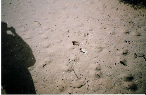
21 Eroding Hearth Surface Scatter Rock Ring
22 Conclusions Predictive modeling is a tool that can and should be used to address the challenges presented to archaeologists interested in nomadic peoples. Caveat emptor however: You only get what you put into the model. Therefore, complex multivariate models of site location built from archaeolgical, ethnoarchaeologal, and ecological data and applied to robust terrain and environmental models should be pursued above other types of modeling. These models not only aid in site location, but also give us the means to test why sites are where they are, and can open up new avenues of research.
23 Conclusions Most importantly, however, it should be stated that predictive models are only the first step. In order to bring the archaeology of Near Eastern nomadic pastoralists to the same level as their agriculturalist neighbours, we must pursue other important research topics, such as site formation studies. Hopefully, the model presented here represents a good first step, and will help bring the archaolgy of nomadic pastoralists into the 21 st century.

24 The End! References: Banning, E. B., and I. Köhler-Rollefson Ethnoarchaeological survey in the Beda area, southern Jordan. Zeitschrift des Deutschen Palastina-Vereins 102: "Ethnographic lessons for the pastoral past: camp locations and material remains near Beidha, southern Jordan," in Pastoralism in the Levant: Archaeological Materials in Anthropological Perspectives, vol. 10, Monographs in World Archaeology, pp Madison: Prehistory Press. Simms, S. R., and K. W. Russell Ethnoarchaeology of the Bedul Bedouin of Petra, Jordan: Implications for the Food producing Transition, Site Structure, and pastoralist Archaeology. Utah State University, Manuscript. For More Information: Land-Use and Landscape Socioecology in the Mediterranean Basin: A Natural Laboratory for the Study of the Long-Term Interaction of Human and Natural Systems NSF Award #
Michael Barton School of Human Evolution & Social Change Center for Social Dynamics & Complexity
 Michael Barton School of Human Evolution & Social Change Center for Social Dynamics & Complexity Social Systems are Complex Even simple social systems are complex Complexity has grown at increasing rate
Kansas Archaeology Month
 Activities for Discovering Prehistoric Trails TIME: 45 min. Kansas Archaeology Month Discovering Prehistoric Trails This lesson is divided into four sections: instructional goals, advanced preparation,
Remote Sensing and Geographic Information System (GIS) Based Analysis of Historic Resources
 Based Analysis of Historic Resources") World War II Additional Material Remote Sensing and Geographic Information System (GIS) Based Analysis of Historic Resources By Nicole Vernon and Patrick O Day, GANDA Remote Sensing and Geographic Information
World War II Additional Material Remote Sensing and Geographic Information System (GIS) Based Analysis of Historic Resources By Nicole Vernon and Patrick O Day, GANDA Remote Sensing and Geographic Information
Your web browser (Safari 7) is out of date. For more security, comfort and the best experience on this site: Update your browser Ignore
 is out of date. For more security, comfort and the best experience on this site: Update your browser Ignore") Your web browser (Safari 7) is out of date. For more security, comfort and the best experience on this site: Update your browser Ignore DOGGERL AND - THE EU RO PE THAT WAS The British Isles were once neither
Your web browser (Safari 7) is out of date. For more security, comfort and the best experience on this site: Update your browser Ignore DOGGERL AND - THE EU RO PE THAT WAS The British Isles were once neither
Description of Simandou Archaeological Potential Model. 12A.1 Overview
 12A Description of Simandou Archaeological Potential Model 12A.1 Overview The most accurate and reliable way of establishing archaeological baseline conditions in an area is by conventional methods of
Integrating Spatial & Temporal Dynamics in Ecological Modeling: Issues & Directions. Michael Barton School of Human Evolution and Social Change
 Integrating Spatial & Temporal Dynamics in Ecological Modeling: Issues & Directions Michael Barton School of Human Evolution and Social Change Ecosystems are dynamic Not just variation, but change across
Table of Contents. Introduction...3 How to Use This Book...4 Standards Information...6 The World in Spatial Terms
 Table of Contents Introduction...................................................................3 How to Use This Book..........................................................4 Standards Information...........................................................6
Central Inuit Household Economies
 B/95324 Central Inuit Household Economies Zooarchaeological, environmental, and historical evidence from outer Frobisher Bay, Baffin Island, Canada Anne Stevens Henshaw BAR International Series 871 2000
Chapter 1: Basic Concepts
 Chapter 1: Basic Concepts The Cultural Landscape: An Introduction to Human Geography Defining Geography Word coined by Eratosthenes Geo = Earth Graphia = writing Geography thus means earth writing Contemporary
Key elements An open-ended questionnaire can be used (see Quinn 2001).
.") Tool Name: Risk Indexing What is it? Risk indexing is a systematic approach to identify, classify, and order sources of risk and to examine differences in risk perception. What can it be used assessing
Tool Name: Risk Indexing What is it? Risk indexing is a systematic approach to identify, classify, and order sources of risk and to examine differences in risk perception. What can it be used assessing
DEPARTMENT OF GEOGRAPHY B.A. PROGRAMME COURSE DESCRIPTION
 DEPARTMENT OF GEOGRAPHY B.A. PROGRAMME COURSE DESCRIPTION (3 Cr. Hrs) (2340100) Geography of Jordan (University Requirement) This Course pursues the following objectives: - The study the physical geographical
World Prehistory. Introduction: Archaeology, Paleontology, and Geology
 World Prehistory Introduction: Archaeology, Paleontology, and Geology Geology Geological eras keyed to earth s geological, climatological, and astronomical history Relevant eras for this course: Pleistocene:
Geography and the Early Settlement of China
 Geography and the Early Settlement of I N T E R A C T I V E S T U D E N T N O T E B O O K How did geography affect life in ancient? P R E V I E W Physical Features 1. Circle the physical features that
Middle School. Assessment Focus: Strand 2 Developing a Geographic Perspective. Geography Content Standard Location, Movement, and Connection
 MS05 Michigan Geographic Alliance(1996) Geography Sample Item Middle School Assessment Focus: Strand 2 Developing a Geographic Perspective Geography Content Standard Location, Movement, and Connection
Environmental Changes, Migration, and Remittances Affect Pastoralist Communities in Montane Central Asia
 Environmental Changes, Migration, and Remittances Affect Pastoralist Communities in Montane Central Asia Geoffrey M. Henebry * Hannah Visiting Professor Center for Global Change & Earth Observations &
Mutah university faculty of Social Sciences The Study plan of the department of Geography 2006/2007
 Mutah university faculty of Social Sciences The Study plan of the department of Geography 2006/2007 Requirements university compulsory 22 Credit hours Course No Credit hours Prerequisite Requirements Faculty
EQ: Discuss main geographic landforms of the U.S. & Canada and examine varied landforms in relation to their lifestyles.
 EQ: Discuss main geographic landforms of the U.S. & Canada and examine varied landforms in relation to their lifestyles. Places & Terms for Discussion Appalachian Mountains Great Plains Canadian Shield
A Small Migrating Herd. Mapping Wildlife Distribution 1. Mapping Wildlife Distribution 2. Conservation & Reserve Management
 A Basic Introduction to Wildlife Mapping & Modeling ~~~~~~~~~~ Rev. Ronald J. Wasowski, C.S.C. Associate Professor of Environmental Science University of Portland Portland, Oregon 8 December 2015 Introduction
Conceptual Understandings for K-2 Teachers
 AFK12SE/NGSS Strand Disciplinary Core Ideas ESS1: Earth s Place in the Universe What is the universe, and what is Earth s place in it? ESS1. A: The Universe and Its Stars What is the universe, and what
COURSE OUTLINE. GEO 101 Geography 3 Course Number Course Title Credits. Reference Liberal Arts Division Book List
 MERCER COUNTY COMMUNITY COLLEGE LIBERAL ARTS DIVISION COURSE OUTLINE GEO 101 Geography 3 Course Number Course Title Credits Required Materials: Catalog Description: Reference Liberal Arts Division Book
Artificial and Real Prehistoric Worlds: Agent Based Modeling in the Prehistoric American Southwest
 Artificial and Real Prehistoric Worlds: Agent Based Modeling in the Prehistoric American Southwest Archaeology: The only discipline with the time range to study long-term culture change. Impossible to
Turkey, Egypt and Italy
 Remote sensing techniques in geoarchaeological research; Case studies in Turkey, Egypt and Italy V. De Laet*, G. Verstraeten, E. Paulissen Center for Archaeological Sciences, K.U.Leuven Celestijnenlaan
Chapter 6. Field Trip to Sandia Mountains.
 University of New Mexico Biology 310L Principles of Ecology Lab Manual Page -40 Chapter 6. Field Trip to Sandia Mountains. Outline of activities: 1. Travel to Sandia Mountains 2. Collect forest community
International Journal of Modern Trends in Engineering and Research e-issn No.: , Date: April, 2016
 International Journal of Modern Trends in Engineering and Research www.ijmter.com e-issn No.:2349-9745, Date: 28-30 April, 2016 Landslide Hazard Management Maps for Settlements in Yelwandi River Basin,
Plate 51. Site 035. Collection of remains. Scale is in cm. Plate 50. Site 034. Collection of remains. Scale is in cm
 Plate 48. Site 033. View facing north west Plate 49. Site 034. View facing north Pottery Pottery Ostrich eggshell Plate 50. Site 034. Collection of remains. Scale is in cm Plate 51. Site 035. Collection
GEOGRAPHY (GEOGRPHY) Geography (GEOGRPHY) 1
 Geography (GEOGRPHY) 1") Geography (GEOGRPHY) 1 GEOGRAPHY (GEOGRPHY) GEOGRPHY 1040 Planet Earth 4 Credits The features of the natural environment (lithosphere, atmosphere and hydrosphere); their character, distribution, origin
Geography (GEOGRPHY) 1 GEOGRAPHY (GEOGRPHY) GEOGRPHY 1040 Planet Earth 4 Credits The features of the natural environment (lithosphere, atmosphere and hydrosphere); their character, distribution, origin
 Prehistory and the Present: Paleoenvironments in the Northern Congo Basin Christopher A. Kiahtipes Washington State University, Department of Anthropology Abstract: The Congo Basin contains a stunning
Gully erosion and associated risks in the Tutova basin Moldavian Plateau
 Landform Analysis, Vol. 17: 193 197 (2011) Gully erosion and associated risks in the Tutova basin Moldavian Plateau University Alexandru Ioan Cuza of Iasi, Department of Geography, Romania, e-mail: catiul@yahoo.com
Chapter 5 LiDAR Survey and Analysis in
 Chapter 5 LiDAR Survey and Analysis in 2010-2011 Christopher Fennell A surveyor s plat and town plan filed in 1836 set out an intended grid of blocks, lots, alleys, and streets for New Philadelphia. Geophysical,
Stratigraphy Layers of Time in the Earth by Carol Schlenk
 Subject: Science, Social Studies Grade level: 11-12 Stratigraphy Layers of Time in the Earth by Carol Schlenk Rationale: This lesson introduces students to the concept of stratification as a historical
Section 8. North American Biomes. What Do You See? Think About It. Investigate. Learning Outcomes
 Section 8 North American Biomes What Do You See? Learning Outcomes In this section, you will Define the major biomes of North America and identify your community s biome. Understand that organisms on land
Studies on adaptation capacity of Carpathian ecosystems/landscape to climate change
 ` Studies on adaptation capacity of Carpathian ecosystems/landscape to climate change Science for the Carpathians CARPATHIAN CONVENTION COP5 Lillafüred, 10.10.2017-12.10.2017 Marcel Mîndrescu, Anita Bokwa
Geographical knowledge and understanding scope and sequence: Foundation to Year 10
 Geographical knowledge and understanding scope and sequence: Foundation to Year 10 Foundation Year 1 Year 2 Year 3 Year 4 Year 5 Year 6 Year level focus People live in places Places have distinctive features
SPATIAL AND TEMPORAL MODELLING OF ECOSYSTEM SERVICES
 SPATIAL AND TEMPORAL MODELLING OF ECOSYSTEM SERVICES Solen Le Clec h, T.Decaëns, S. Dufour, M. Grimaldi, N. Jégou and J. Oszwald ACES Conference 2016 Jacksonville, Florida (USA). December, 5-9th : issues
Landuse and Landcover change analysis in Selaiyur village, Tambaram taluk, Chennai
 Landuse and Landcover change analysis in Selaiyur village, Tambaram taluk, Chennai K. Ilayaraja Department of Civil Engineering BIST, Bharath University Selaiyur, Chennai 73 ABSTRACT The synoptic picture
Modelling forager land-use by close-coupling ABM and GIS
 Modelling forager land-use by close-coupling ABM and GIS Mark Lake Institute of Archaeology Agenda What is agent-based GIS? Research problem Why take an agent-based approach? Overview of the model The
Climate Change: How it impacts Canadians and what we can do to slow it down.
 Climate Change: How it impacts Canadians and what we can do to slow it down. Lesson Overview This lesson takes stock of how climate change has already affected Canadians in geographic, economic, and cultural
GEOGRAPHY (GE) Courses of Instruction
 Courses of Instruction") GEOGRAPHY (GE) GE 102. (3) World Regional Geography. The geographic method of inquiry is used to examine, describe, explain, and analyze the human and physical environments of the major regions of the
GEOGRAPHY (GE) GE 102. (3) World Regional Geography. The geographic method of inquiry is used to examine, describe, explain, and analyze the human and physical environments of the major regions of the
Spatial Model of the First Bulgarian Capital Pliska Based on Remote Sensing and Ground- Based Data. Stefan Stamenov, Bulgaria
 Spatial Model of the First Bulgarian Capital Pliska Based on Remote Sensing and Ground- Based Data Stefan Stamenov, Bulgaria 1 Location of the study area 2 PURPOSE OF THE STUDY The purpose of this paper
USING HYPERSPECTRAL IMAGERY
 USING HYPERSPECTRAL IMAGERY AND LIDAR DATA TO DETECT PLANT INVASIONS 2016 ESRI CANADA SCHOLARSHIP APPLICATION CURTIS CHANCE M.SC. CANDIDATE FACULTY OF FORESTRY UNIVERSITY OF BRITISH COLUMBIA CURTIS.CHANCE@ALUMNI.UBC.CA
Directorate E: Sectoral and regional statistics Unit E-4: Regional statistics and geographical information LUCAS 2018.
 EUROPEAN COMMISSION EUROSTAT Directorate E: Sectoral and regional statistics Unit E-4: Regional statistics and geographical information Doc. WG/LCU 52 LUCAS 2018 Eurostat Unit E4 Working Group for Land
The Driftless Area. Dave Speer Geography 326
 The Driftless Area Dave Speer Geography 326 Introduction: Wisconsin s landscape is defined by many physical features resulting from continental glaciation. Wisconsin is unique in the fact that it possesses
Interdisciplinary Data Management: An Example from NSF s Dynamics of Coupled Natural and Human Systems Program
 Interdisciplinary Data Management: An Example from NSF s Dynamics of Coupled Natural and Human Systems Program Steven Fassnacht, Watershed Science with Melinda Laituri, Watershed Science; Sophia Linn,
School of Geography and Geosciences. Head of School Degree Programmes. Programme Requirements. Modules. Geography and Geosciences 5000 Level Modules
 School of Geography and Geosciences Head of School Degree Programmes Graduate Diploma: Dr W E Stephens Health Geography Research Environmental History and Policy (see School of History) M.Res.: M.Litt.:
Moreton Bay and Key Geographic Concepts Worksheet
 Moreton Bay and Key Geographic Concepts Worksheet The Australian Curriculum: Geography draws on seven key geographic concepts: place scale space environment change interconnection sustainability They are
Grade Five Social Studies Assessment Regions/Native Americans
 Name Grade Five Social Studies Assessment Regions/Native Americans Use the map below to answer questions 1 and 2 1. (Geo 1) For this location give the name of the city found there. 38 N, 100 W a. Scottsbluff
Chapter 1: Basic Concepts
 Chapter 1: Basic Concepts The Cultural Landscape: An Introduction to Human Geography Defining Geography Word coined by Eratosthenes Geo = Earth Graphia = writing Geography thus means earth writing Contemporary
OAKLYN PUBLIC SCHOOL
 Content Area: Science OAKLYN PUBLIC SCHOOL Unit Title: Unit C - Earth and Beyond Target Course/Grade Level: Fourth Grade Unit Summary: The Earth is in constant change. Earth s materials, such as rocks
Understanding the Predynastic. the beginnings of ancient Egyptian civilization
 Understanding the Predynastic the beginnings of ancient Egyptian civilization The development of agriculture may have been promoted by climate changes that began around 7000 BC. Settled agricultural communities
GRADE LEVEL EXPECTATIONS CORRELATION NOTATIONS
 Book Title: World Studies: The Eastern Hemisphere 2005 Grade Level: 6 Publisher: Pearson Prentice Hall Subject/Course: Social Studies, Grade 6 Geography The World in Spatial Terms Grade 6 1. Use latitude
THE INDIAN COMMUNITY SCHOOL, KUWAIT
 THE INDIAN COMMUNITY SCHOOL, KUWAIT SERIES : I TERM /AN/ 2018-2019 CODE : H 087 TIME ALLOWED : 3 HOURS NAME OF STUDENT : MAX. MARKS : 80 ROLL NO. :.. CLASS/SEC :.. NO. OF PAGES : 2 + 1 MAP SOCIAL SCIENCE
Chapter 6, Part Colonizers arriving in North America found extremely landscapes. It looked different to region showing great.
 Social Studies 9 Unit 1 Worksheet Chapter 6, Part 1. 1. Colonizers arriving in North America found extremely landscapes. It looked different to region showing great. 2. The Earth is years old and is composed
For GE and Unrestricted Elective course conversions visit
 Sub plan/option: Geographic Information Systems GEO222/222A Introduction to Cartography* 3/1 * 3 GEO309 Field Geography 4 GEO3090/3090L Introduction to Field Geography/Laboratory 2/1 GEO305 Advanced Physical
Site Suitability Analysis for Local Airport Using Geographic Information System
 Cloud Publications International Journal of Advanced Remote Sensing and GIS 2018, Volume 7, Issue 1, pp. 2719-2727 ISSN 2320 0243, Crossref: 10.23953/cloud.ijarsg.368 Research Article Site Suitability
Year 9 plan Victorian Curriculum: Humanities Semester Two (Geography/Economics and Business)
") Year 9 plan Victorian Curriculum: Humanities Semester Two (Geography/Economics and Business) Implementation year: School name: Kyabram P-12 College Prepared By: Rowena Morris Identify Curriculum Curriculum
Year 9 plan Victorian Curriculum: Humanities Semester Two (Geography/Economics and Business) Implementation year: School name: Kyabram P-12 College Prepared By: Rowena Morris Identify Curriculum Curriculum
UNIT4. Ancient China. Geography and the Early Settlement of China. Three Chinese Philosophies The First Emperor of China
 UNIT4 Ancient China Lesson 19 Lesson 20 Lesson 21 Lesson 22 Lesson 23 Lesson 24 Geography and the Early Settlement of China The Shang Dynasty Three Chinese Philosophies The First Emperor of China The Han
Role of GIS and Remote Sensing to Environment Statistics
 United Nations Economic Commission for Africa Role of GIS and Remote Sensing to Environment Dozie Ezigbalike Data Management Coordinator A Definition Environment statistics are statistics that describe
Quarterly Pacing Guide 6th grade Social Studies Content Expectations
 6.G1 The World in Spacial Term Terms: Geographical Habits of Mind 6.G1.1 Spacial Thinking 6 - G1.1.1 Use maps, globes, and web based geography technology to investigate the world at global, interregional,
RESEARCH CENTRE OF ASTRONOMY & GEOPHYSICS OF MONGOLIAN ACADEMY OF SCIENCES. Seismicity of Mongolia and activity around Ulaanbaatar city
 RESEARCH CENTRE OF ASTRONOMY & GEOPHYSICS OF MONGOLIAN ACADEMY OF SCIENCES Seismicity of Mongolia and activity around Ulaanbaatar city Topic. Brief information about Mongolia Development of Seismology
Application of Remote Sensing and GIS in Seismic Surveys in KG Basin
 P-318 Summary Application of Remote Sensing and GIS in Seismic Surveys in KG Basin M.Murali, K.Ramakrishna, U.K.Saha, G.Sarvesam ONGC Chennai Remote Sensing provides digital images of the Earth at specific
World Geography Chapter 3
 World Geography Chapter 3 Section 1 A. Introduction a. Weather b. Climate c. Both weather and climate are influenced by i. direct sunlight. ii. iii. iv. the features of the earth s surface. B. The Greenhouse
History EC LE UE MS. Knows the names and order of the Seasons of the Year and science behind it
 History EC LE UE MS Time and Timelines : awareness of how the universe and life came to be and his/her place on the continuum. The child discovers interests, makes connections and draws inferences about
Spatial Disaggregation of Land Cover and Cropping Information: Current Results and Further steps
 CAPRI CAPRI Spatial Disaggregation of Land Cover and Cropping Information: Current Results and Further steps Renate Koeble, Adrian Leip (Joint Research Centre) Markus Kempen (Universitaet Bonn) JRC-AL
18.2 Earth Cycles Days and years Calendars Years and days Leap years Calendars throughout human history 20,000 years ago. 7,000 BC. 4,000 BC.
 18.2 Reading 18.2 Earth Cycles Do you ever wonder where our calendar comes from? Or why the Moon gradually changes its shape? Or why we have seasons? The answers have to do with the relative positions
New Geography A Levels from Martin Evans, University of Manchester
 New Geography A Levels from 2016 Martin Evans, University of Manchester How did we get to here? Smith Report June 2013 A-Level Reform Timeline Public Consultation Autumn 2013 Geography Referred to ALCAB
Chapter 1: Introduction to Safety and Ethics
 Core Curriculum Standards Met by Each Chapter On the Right Trail meets Utah s Social Studies Core Curriculum Standards for grades 3-7. Each chapter has specific standard objectives, which are met by the
A future for GIS in Archaeology: the integration of theory and analysis
 A future for GIS in Archaeology: the integration of theory and analysis Gary Lock and John Pouncett University of Oxford, UK Since the late 1980s GIS for Cultural Resource Management, mapping, data management
Meteorology. Chapter 15 Worksheet 1
 Chapter 15 Worksheet 1 Meteorology Name: Circle the letter that corresponds to the correct answer 1) The Tropic of Cancer and the Arctic Circle are examples of locations determined by: a) measuring systems.
Advanced Placement Human Geography
 Advanced Placement Human Geography Introduction to AP Human Geography The Advanced Placement course in Human Geography is designed to introduce students to the systematic study of the processes that have
Stage 2 Geography. Assessment Type 1: Fieldwork. Student Response
 Stage 2 Geography Assessment Type 1: Fieldwork Student Response Page 1 of 21 Page 2 of 21 Page 3 of 21 Image removed due to copyright. Page 4 of 21 Image removed due to copyright. Figure 5: A cause of
Steve Pye LA /22/16 Final Report: Determining regional locations of reference sites based on slope and soil type. Client: Sonoma Land Trust
 Steve Pye LA 221 04/22/16 Final Report: Determining regional locations of reference sites based on slope and soil type. Client: Sonoma Land Trust Deliverables: Results and working model that determine
EGYPTIAN AMERICAN INTERNATIONAL SCHOOL Elementary Social Studies Department GRADE 5 Semester 1 Exams- Review. Name: Grade: Date:
 1 EGYPTIAN AMERICAN INTERNATIONAL SCHOOL Elementary Social Studies Department GRADE 5 Semester 1 Exams- Review Name: Grade: Date: Part A- Choose the correct answer for the following 1. Geographers create
Chapter 1 Quantitative Analysis of Geomorphometric Parameters of Wadi Kerak, Jordan, Using Remote Sensing and GIS
 Chapter 1 Quantitative Analysis of Geomorphometric Parameters of Wadi Kerak, Jordan, Using Remote Sensing and GIS Yahya Farhan, Ali Anbar, Omar Enaba, Nisrin Al-Shaikh Geomorphometric analysis was carried
Planning an Earth and Space science course
 Earth and Space Science Y12 and Y13 It is essential with the problems facing planet Earth that students have a working knowledge of how all the Earth system (geosphere, atmosphere, hydrosphere and biosphere)
South Carolina Standards & Learning Science Grade: 1 - Adopted: 2014
 Main Criteria: South Carolina Standards & Learning Secondary Criteria: Subjects: Science, Social Studies Grade: 1 Correlation Options: Show Correlated South Carolina Standards & Learning Science Grade:
G E O G RAP H Y Geomorphology: Climatology : Oceanography: Geographic Thought : Population Geography :
 GEOGRAPHY SYALLABUS Geomorphology: Fundamental concepts; Endogenetic and Exogenetic forces; Denudation and weathering; Geosynclines, continental drift and plate tectonics; Concept of geomorphic cycle;
Eagle Creek Post Fire Erosion Hazard Analysis Using the WEPP Model. John Rogers & Lauren McKinney
 Eagle Creek Post Fire Erosion Hazard Analysis Using the WEPP Model John Rogers & Lauren McKinney Columbia River Gorge at Risk: Using LiDAR and GIS-based predictive modeling for regional-scale erosion susceptibility
Lesson Graphic Organizer
 Lesson Graphic Organizer Theme Location Where is it? Questions What is its absolute location? What is its relative location? Place What is it like there? What are its natural characteristics? What are
Ancient China UNIT 4 GEOGRAPHY CHALLENGE. 1 Unit 4 Geography Challenge. Teachers Curriculum Institute
 UNIT 4 GEOGRAPHY CHALLENGE Ancient China N W E S 0 250 500 miles 0 250 500 kilometers Albers Conic Equal-Area Projection AW_ISN_U04_01 Ancient China Second Proof TCI18 108 1 Unit 4 Geography Challenge
Alliance Created State Giant Traveling Map Lesson
 Title: Comparing Arizona s Temperatures Recommended Grades: 4 th 5 th Time Needed: 30 minutes Objectives: Students will: Compare and contrast the geographic features of Arizona by researching seasonal
Department of Geography: Vivekananda College for Women. Barisha, Kolkata-8. Syllabus of Post graduate Course in Geography
 India: Regional Problems and Resource management Module 11 (Full Marks 50) Unit I: Region and Regionalisation 1.1 Various bases of regionalisation of India; problems of identification and delineation.
student pretest Stewardship Project middle school (Grades 7-8)
") student pretest Stewardship Project middle school (Grades 7-8) 1. True or False. Solar energy is radiant energy carried through the sun s heat and light. 2. Yes or No. Does solar energy dissipate as it
student pretest Stewardship Project middle school (Grades 7-8) 1. True or False. Solar energy is radiant energy carried through the sun s heat and light. 2. Yes or No. Does solar energy dissipate as it
5th social studies geography (5thsocstud_geography)
") Name: Date: 1. Many of the Native Americans who lived on the Great Plains were nomadic people. Why did they move from place to place? A. They were finding new areas to mine. B. They were looking for fertile
Name: Date: 1. Many of the Native Americans who lived on the Great Plains were nomadic people. Why did they move from place to place? A. They were finding new areas to mine. B. They were looking for fertile
The structure of the Earth and how its motion creates the seasons. The landforms of the earth and the forces that shape the land.
 The structure of the Earth and how its motion creates the seasons. The landforms of the earth and the forces that shape the land. The role of wind and water in creating climate. The different climate and
Book Title: World Studies, Medieval Times to Today 2005 Grade Level: 6 Publisher: Pearson Prentice Hall Subject/Course: Social Studies, Grade 6
 Book Title: World Studies, 2005 Grade Level: 6 Publisher: Pearson Prentice Hall Subject/Course: Social Studies, Grade 6 Geography The World in Spatial Terms Grade 6 1. Use latitude and longitude to determine
The Use of Random Geographic Cluster Sampling to Survey Pastoralists. Kristen Himelein, World Bank Addis Ababa, Ethiopia January 23, 2013
 The Use of Random Geographic Cluster Sampling to Survey Pastoralists Kristen Himelein, World Bank Addis Ababa, Ethiopia January 23, 2013 Paper This presentation is based on the paper by Kristen Himelein
VILLAGE INFORMATION SYSTEM (V.I.S) FOR WATERSHED MANAGEMENT IN THE NORTH AHMADNAGAR DISTRICT, MAHARASHTRA
 FOR WATERSHED MANAGEMENT IN THE NORTH AHMADNAGAR DISTRICT, MAHARASHTRA") VILLAGE INFORMATION SYSTEM (V.I.S) FOR WATERSHED MANAGEMENT IN THE NORTH AHMADNAGAR DISTRICT, MAHARASHTRA Abstract: The drought prone zone in the Western Maharashtra is not in position to achieve the agricultural
VILLAGE INFORMATION SYSTEM (V.I.S) FOR WATERSHED MANAGEMENT IN THE NORTH AHMADNAGAR DISTRICT, MAHARASHTRA Abstract: The drought prone zone in the Western Maharashtra is not in position to achieve the agricultural
Vanishing Species 5.1. Before You Read. Read to Learn. Biological Diversity. Section. What do biodiversity studies tell us?
 Vanishing Species Before You Read Dinosaurs are probably the most familiar organisms that are extinct, or no longer exist. Many plants and animals that are alive today are in danger of dying out. Think
What do you think? Should the development of cold environments continue? Is there a better way?
 What do you think? Should the development of cold environments continue? Is there a better way? What is the future for the development of cold environments? d) With reference to one or more examples, Outline
Reading for Information Grade 2 Correlations to Alabama State Curriculum
 Grade 2 Correlations to Alabama State Curriculum Science Strand Life Science Earth Science Physical Science Grade 2 Leveled Plants Live and Grow Plants: Alive and Growing Plants: Living and Growing All
Marr College Geography Department. Can-Do Checklist for Higher Geography
 Marr College Geography Department Can-Do Checklist for Higher Geography The Higher Geography exam consists of one paper. It is out of a total of 60 marks. The total time for the paper is 2 hours 15 minutes.
Dawood Public School Secondary Section Class VII
 Dawood Public School Secondary Section Class VII Introduction: Geography is the study of the Earth and its lands, features, inhabitants, and phenomena relating to the sciences of aforementioned. This subject
Unit 6 Lesson 1 How Do the Sun, Earth, and Moon Interact? Copyright Houghton Mifflin Harcourt Publishing Company
 Unit 6 Lesson 1 How Do the Sun, Earth, and Moon Interact? Night and Day Earth rotates, or turns like a top. Earth s rotation causes day and night. Earth rotates around an imaginary line called an axis,
Book Title: History of Our World, The Early Ages Edition 2005 Grade Level: 6 Publisher: Pearson Prentice Hall Subject/Course: World History, Grade 6
 Book Title: History of Our World, The Early Ages Edition 2005 Grade Level: 6 Publisher: Pearson Prentice Hall Subject/Course: World History, Grade 6 Geography The World in Spatial Terms Grade 6 1. Use
PÀ ÁðlPÀ gádå G À Áå ÀPÀgÀ CºÀðvÁ ÀjÃPÉë KARNATAKA STATE ELIGIBILITY TEST FOR LECTUERSHIP
 PÀ ÁðlPÀ gádå G À Áå ÀPÀgÀ CºÀðvÁ ÀjÃPÉë KARNATAKA STATE ELIGIBILITY TEST FOR LECTUERSHIP Subject: GEOGRAPHY Subject Code: 08 Note: There will be two question papers, Paper-II and Paper-III. Paper II will
Topic: Megalithic Culture in Chhattisgarh: Insight from the Ethnographic Tradition
 Ph.D Synopsis Topic: Megalithic Culture in Chhattisgarh: Insight from the Ethnographic Tradition By: Tirtharaj Bhoi Department of History School of Social Sciences University of Hyderabad Hyderabad 2009
Comparing the Land Use and Land Cover Changes Between the North and South Louisiana Using Data Mining
 Comparing the Land Use and Land Cover Changes Between the North and South Louisiana Using Data Mining Yi Qiang and Nina Lam Department of Environmental Sciences Louisiana State University yqiang1@lsu.edu,
ESTIMATION OF LANDFORM CLASSIFICATION BASED ON LAND USE AND ITS CHANGE - Use of Object-based Classification and Altitude Data -
 ESTIMATION OF LANDFORM CLASSIFICATION BASED ON LAND USE AND ITS CHANGE - Use of Object-based Classification and Altitude Data - Shoichi NAKAI 1 and Jaegyu BAE 2 1 Professor, Chiba University, Chiba, Japan.
Environmental and Cultural Factors Influencing Parthian Archaeological Site Distribution in the Sarfirouzabad Plain of Kermanshah, Northwest of Iran
 International Journal of Geosciences, 2013, 4, 69-77 http://dx.doi.org/10.4236/ijg.2013.41008 Published Online January 2013 (http://www.scirp.org/journal/ijg) Environmental and Cultural Factors Influencing
Unit 1 All. Study online at quizlet.com/_3l51hr
 Unit 1 All Study online at quizlet.com/_3l51hr 1. geography: 4. 7 APHG Units+: The study of the distribution and interaction of physical and human features on the earth 2. physical geography: 1. Geography: