Update on Archaeological Resources Assessment for Phase 1 Dredge Areas
|
|
|
- Jocelin Golden
- 5 years ago
- Views:
Transcription
1 Update on Archaeological Resources Assessment for Phase 1 Dredge Areas Prepared by URS Corp for General Electric Presented by John Vetter, USEPA CAG Meeting December 8,
2 Presentation Outline Overview of the Shoreline Reconnaissance Description of submerged resources associated with Phase 1 dredge areas Description of riverbank areas that may be impacted during Phase 1 dredging and contain terrestrial archaeological sites. Summary of resources and additional data needs.


3 July-September Shoreline reconnaissance, by small boat and on foot, of ALL Phase 1 Dredge Areas (regardless of sensitivity classification) 2. Systematic surface inspection and shovel test pit survey along shorelines where needed 3. Underwater archaeological survey of remote sensing targets and historically sensitive areas
4 Underwater (just barely) Archaeology
5 Recap of Underwater Methods Extensive remote sensing conducted prior to underwater field work side-scan sonar multibeam bathymetry survey sub-bottom profiling with groundpenetrating radar (GPR) magnetometer (metal detector). Systematic diver sweeps Mapping and photography No excavation of bottom sediments due to PCBs


6 Inspection of entire channel east of Rogers Island Scattered glass and pottery but no intact deposits


7 Ceramics & Glass from the East Channel Date range 1840 to to to to to to to to to to to to to to to to to 1960 Pre 1920


8 Glass soda or beer bottle date range JOHN MAHON BOTTLER FORT EDWARD, N.Y. CONTENTS 8 OZ. REGISTRED. Stoneware bottle, wheel thrown, saltglazed, buff body, impressed at shoulder date range BURDOCK & CO.


9 One gallon stoneware jug Bristol glaze and dark brown slip glaze date range Salt-glazed stoneware jug or jar sherd Albany interior slip date range FORT EDWARE... /FORT E...


10 U-1


11 U-2

12


13 U3 and U-4


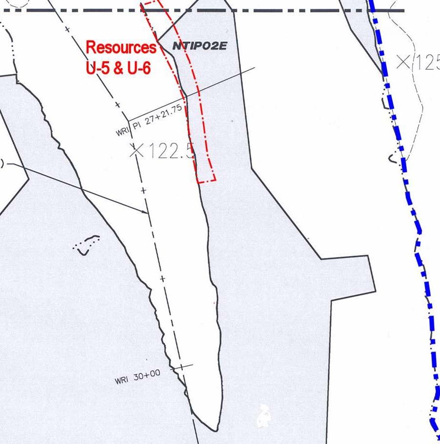

14 U-5 and U-6


15 Canal boats worked hard, withstood tremendous abuse, and rotted quickly after abandonment


16 U-7


17 U-7


18 U-7


19 U8, U9, U10


20 U8 (SS-319), U9, U10 NOAA Chart 2003 Sonar 2005 Magnetometer

21 U8 (SS-319) 2003 Sonar 2005 Diver Photo 2005 Sonar
22 U Sonar 2005 Sonar


23 NOAA Chart U Sonar 2005 Sonar
24 Summary: Underwater Sites Phase 1 dredging program would have an impact on underwater archaeological resources that are potentially NRHP-eligible. However, larger excavation exposures are needed to: assess their physical integrity evaluate their internal content and structure determine if they possess distinctive construction features associated with historically important contexts. To obtain the necessary information to determine these resources eligibility for the NRHP, it would be necessary to disturb and remove the PCB-containing sediments over and around them. Further discussions are needed to resolve this issue.

")

25 Terrestrial Studies Crew of six people for three weeks (reconnaissance and survey) 180 shovel test pits (STPs) were excavated in 14 separate Test Areas. Over 1,600 artifacts found
26 Terrestrial Artifacts Southern NTIP & Griffin Island Area discussed in report in more detail Southern NTIP has sites in need of investigation prior to Phase 2 dredging but not for Phase 1 Eastern Griffin Island Area has no terrestrial or submerged sites in need of further investigation Area Total Historic Prehistoric A B C D E F G H I J K L M N O P Q R


27 Northern Part of NTIP


28 Area G


29 Northern Part of NTIP


30 Area H


31 Northern Part of NTIP

32 Cribbing in riverbank


33 Area L
34 Summary: Terrestrial Sites Area G: a structural foundation and artifact deposits near the shoreline that appear to date to the mid to late nineteenth century. Area L: the cellar hole of a nineteenth century structure has been identified, but it is unclear whether artifact deposits or associated features extend to the river bank. In addition, there is the possibility of deeply buried prehistoric layers. Area H: the 18th century site of Fort Edward was previously determined eligible for the NRHP, but the boundaries of intact deposits associated with that site have not been established.
35 What Next? Terrestrial Sites In Areas G, H, and L, we have identified potentially significant deposits near the river bank. Additional data are needed for NRHP eligibility determination and impact assessment: larger sample of artifacts recovered from controlled excavations horizontal exposures from bigger excavation units to expose cultural features and their stratigraphic contexts.
36 What Next? Terrestrial Sites Need to determine impacts of dredging on any NRHP-eligible resources and identify dredge design project modifications that might be needed to prevent or mitigate any adverse impacts. Need to know what portions of any eligible sites might be impacted by the dredging and in what way. Data on depth, thickness, soil characteristics, etc, needed to assess how vulnerable a site may be to activities such as nearby dredging, installation of erosion control measures, and backfilling and restoration.
Archaeological Survey and Evaluation at 8954 El Dorado Parkway, El Cajon, San Diego County, California
 April 16, 2013 Ms. Andrea Bitterling Helix Environmental Planning, Inc. 7578 El Cajon Blvd., Suite 200 El Cajon, California 91942 Re: Archaeological Survey and Evaluation at 8954 El Dorado Parkway, El
Archaeological Glossary
 Archaeological Glossary analysis: the stage of archaeological research that involves the description and classification of archaeological data. anthropology: the study of humans, including the variety
MINNESOTA DEEP TEST PROTOCOL PROJECT
 MINNESOTA DEEP TEST PROTOCOL PROJECT Mn/DOT Agreement No. 85878 OSA License No. 04-030 Authorized and Sponsored by: MINNESOTA DEPARTMENT OF TRANSPORTATION FEDERAL HIGHWAY ADMINISTRATION Prepared by COMMONWEALTH
2007 Raleigh Colony Investigation: Magnetic Anomaly Identification & Assessment Roanoke Sound and Shallowbag Bay Roanoke Island, North Carolina
 2007 Raleigh Colony Investigation: Magnetic Anomaly Identification & Assessment Roanoke Sound and Shallowbag Bay Roanoke Island, North Carolina 2007 Raleigh Colony Investigation: Magnetic Anomaly Identification
PHASE 1 STUDIES UPDATE EROSION WORKING GROUP
 PHASE 1 STUDIES UPDATE EROSION WORKING GROUP Presented By MICHAEL WOLFF, PG Erosion Study Area Manager West Valley Demonstration Project Quarterly Public Meeting February 24, 2016 OUTLINE Study 1 Terrain
Remedial Program. GE Hudson Falls Plant Site. GE Hudson Falls Plant Site. TDCS Status
 Updates on Remedial Programs at the GE Hudson Falls Plant Site and GE Fort Edward Plant Site GE Hudson Falls USEPA Community Advisory Group Meeting September 11, 2008 GE Fort Edward Division of Environmental
David Moore, PacifiCorp Cultural Resources Coordinator Denise DeJoseph, Project Archaeologist
 References DeJoseph, Denise 2011 Lewis River HPMP: Swift Camp FSC Survey Negative Results. Memo report submitted by Historical Research Associates to PacifiCorp, Portland, Oregon. Copies available at PacifiCorp,
Habitat Monitoring Update Hudson River CAG November 16, 2017
 Habitat Monitoring Update Hudson River CAG November 16, 2017 Habitat Reconstruction Overview: Habitats A habitat replacement program is being implemented in an Adaptive Management context to reconstruct
Highland Lake Bathymetric Survey
 Highland Lake Bathymetric Survey Final Report, Prepared For: The Town of Highland Lake 612 Lakeshore Drive Oneonta, AL 35121 Prepared By: Tetra Tech 2110 Powers Ferry Road SE Suite 202 Atlanta, GA 30339
APPENDIX K NATIONAL HISTORIC PRESERVATION ACT COORDINATION BRAZOS ISLAND HARBOR CHANNEL IMPROVEMENT PROJECT CAMERON COUNTY, TEXAS
 APPENDIX K NATIONAL HISTORIC PRESERVATION ACT COORDINATION BRAZOS ISLAND HARBOR CHANNEL IMPROVEMENT PROJECT CAMERON COUNTY, TEXAS U.S. Army Corps of Engineers, Galveston District 2000 Fort Point Road Galveston,
Appendix I. Dredged Volume Estimates. Draft Contractor Document: Subject to Continuing Agency Review
 Appendix I Dredged Volume Estimates Draft Contractor Document: Subject to Continuing Agency Review Interoffice Correspondence Date: April 6, 2007 To: L. Bossi (WHI) Copy: S. Thompson (WHI), B. Fidler (NNJ)
ARCHAEOLOGICAL INVESTIGATION George Street Haymarket
 ARCHAEOLOGICAL INVESTIGATION 710-722 George Street Haymarket VOLUME 4: Thomas Ball Pottery Appendices Report to Inmark June 2011 VOLUME 4: Thomas Ball Pottery Appendices Appendix 4.1: Pottery Tables Appendix
December 13, Kirk Shields Green Mountain Power 163 Acorn Lane Colchester, VT 05446
 December 13, 2017 Kirk Shields Green Mountain Power 163 Acorn Lane Colchester, VT 05446 RE: End of Field Letter for Archaeological Phase II Site Evaluation at Site VT-CH-1218 within the Proposed Milton
ACQUISITION, PROCESSING AND INTERPRETATION TECHNIQUES FOR GROUND-PENETRATING RADAR MAPPING OF BURIED PIT-STRUCTURES IN THE AMERICAN SOUTHWEST
 ACQUISITION, PROCESSING AND INTERPRETATION TECHNIQUES FOR GROUND-PENETRATING RADAR MAPPING OF BURIED PIT-STRUCTURES IN THE AMERICAN SOUTHWEST Lawrence B. Conyers Deparunent of Anthropology, University
Name. Designed and Produced for the Orleans County Historical Society by Andrew R. Beaupré, RPA
 Name Archaeology! Archeology! What is Archaeology? Archaeology is the scientific study of people of the past by studying the places people lived, the objects they used, and traces in the soil left by human
ANALYSIS OF SEISMIC PROFILES AND SIDE-SCAN SONAR RECORDS FROM LOWER NEW YORK HARBOR, A PROGRESS REPORT. Roger D. Flood Vicki Lynn Ferrini
 45 ANALYSIS OF SISMIC PROFILS AND SID-SCAN SONAR RCORDS FROM LOWR NW YORK HARBOR, A PROGRSS RPORT Roger D. Flood Vicki Lynn Ferrini Marine Sciences Research Center State University of New York, Stony Brook,
AN ARCHAEOLOGICAL SURVEY FOR THE EASTHAM STATE PRISON FARM UNIT PROJECT IN HOUSTON COUNTY TEXAS
 AN ARCHAEOLOGICAL SURVEY FOR THE EASTHAM STATE PRISON FARM UNIT PROJECT IN HOUSTON COUNTY TEXAS Antiquities Permit 5693 By William E. Moore and Edward P. Baxter Brazos Valley Research Associates Contract
EEEEEEE. 7 nd-a1?2 ii7 STATEMENT OF NEGATIVE FINDINGS ON THE TEST EXCAVATIONS 1;1
 7 nd-a1?2 ii7 STATEMENT OF NEGATIVE FINDINGS ON THE TEST EXCAVATIONS 1;1 AT THE REUNION SITE -- 32WA406(U) NORTH DAKOTA UNIY GRAND FORKS DEPT OF ANTHROPOLOGY AND ARCHAEOLOGY UNCLASSFIE EEEEEEE L L LOENDORF
Sediment Basin Project, Savannah Harbor, Georgia
 University of South Carolina Scholar Commons Research Manuscript Series Archaeology and Anthropology, South Carolina Institute of 11-1973 Sediment Basin Project, Savannah Harbor, Georgia Leland G. Ferguson
PW Parkway ES Prince William County, Virginia WSSI #
 PW Parkway ES Prince William County, Virginia WSSI #15.3 Cultural Resources Site Assessment November 15 Prepared for: Prince William County Public Schools P.O. Box 39 Manassas, Virginia 1 Prepared by:
Archaeology and Geophysics at the Chillicothe Site, Ohio, USA
 info@gemsys.on.ca Archaeology and Geophysics at the Chillicothe Site, Ohio, USA In this short paper, we summarize the recent procedings of the National Parks Service Archaeology Workshop in Chillicothe,
EXTREMELY FAST IP USED TO DELINEATE BURIED LANDFILLS. Norman R. Carlson, Cris Mauldin Mayerle, and Kenneth L. Zonge
 EXTREMELY FAST IP USED TO DELINEATE BURIED LANDFILLS Norman R. Carlson, Cris Mauldin Mayerle, and Kenneth L. Zonge Zonge Engineering and Research Organization, Inc. 3322 East Fort Lowell Road Tucson, Arizona,
Archaeological Monitoring Report
 Archaeological Monitoring Report High Lodge, Santon Downham SMR Nos. STN 067, STN 068 A REPORT ON THE ARCHAEOLOGCAL MONTORNG, 2002 Andrew Tester Field Team Suffolk C.C. Archaeological Service November
Geophysical Investigation of a 19th Century Archeological Site, Boston College K. Corcoran, J. Hager, M. Carnevale
 Geophysical Investigation of a 19th Century Archeological Site, Boston College K. Corcoran, J. Hager, M. Carnevale Hager GeoScience, Inc., Waltham, MA ------------------------------------------------------------------------
Sacred Lands File & Native American Contacts List Request
 Sacred Lands File & Native American Contacts List Request NATIVE AMERICAN HERITAGE COMMISSION 915 Capitol Mall, RM 364 Sacramento, CA 95814 (916) 653-4082 (916) 657-5390 Fax nahc@pacbell.net Information
Stabilization Study. Prepared For: The Town of Bethlehem. Henry Hudson Park Shoreline Stabilization Study. June 2011
 Henry Hudson Park Shoreline Stabilization Study Prepared For: The Town of Bethlehem 1 Company Introduction - OCC Ocean and Coastal Consultants (OCC) is a 50 person engineering consulting firm that specializes
Archaeological Survey and Assessment of Four Wastewater Interceptor Routes in Garner, Wake Co., N.C. (EPA C )
") Archaeological Survey and Assessment of Four Wastewater Interceptor Routes in Garner, Wake Co., N.C. (EPA C370623-02) By H. Trawick \vard R. P. Stephen Davis Prepared by the Research Laboratories of Anthropology
Archaeological Survey and Assessment of Four Wastewater Interceptor Routes in Garner, Wake Co., N.C. (EPA C370623-02) By H. Trawick \vard R. P. Stephen Davis Prepared by the Research Laboratories of Anthropology
DRAFT
 A84536-22, A81184-3 Discovery of Human Remains On Site Lead Licensing and Environmental Assessment Archaeologist Manitoba Historic Resources Branch (HRB) RCMP STOP activities at location Step 6
ENCE 3610 Soil Mechanics. Site Exploration and Characterisation Field Exploration Methods
 ENCE 3610 Soil Mechanics Site Exploration and Characterisation Field Exploration Methods Geotechnical Involvement in Project Phases Planning Design Alternatives Preparation of Detailed Plans Final Design
Barbuda Historical Ecology Project Assessment for Qualitative Field Analysis of Phosphates on Barbuda
 Barbuda Historical Ecology Project 2009 Assessment for Qualitative Field Analysis of Phosphates on Barbuda Cory Look Anthropology Department Brooklyn College and CUNY Graduate Center CLook@gc.cuny.edu
CHAPTER 4. Blue Heron Site (47Je1001) 2003 Investigations. By Chrisie L. Hunter
 2003 Investigations. By Chrisie L. Hunter") CHAPTER 4 Blue Heron Site (47Je1001) 2003 Investigations By Chrisie L. Hunter Introduction The Blue Heron site (47Je1001) is on the property of the Crescent Bay Hunt Club, which is located in the NE 1/4
CHAPTER 4 Blue Heron Site (47Je1001) 2003 Investigations By Chrisie L. Hunter Introduction The Blue Heron site (47Je1001) is on the property of the Crescent Bay Hunt Club, which is located in the NE 1/4
ARCHAEOLOGICAL METHOD FEHMARN STYLE
 ARCHAEOLOGICAL METHOD FEHMARN STYLE Digital archaeology By: Nadja M. K. Mortensen, Prehistoric Archaeologist, Responsible for GIS Overview of the survey area Digital measuring and registration are an important
MARINE GEOLOGY & GEOGRAPHY
 MARINE GEOLOGY & GEOGRAPHY Bathymetry BATHYMETRY BATHYMETRY THE UNDERWATER EQUIVALENT TO TOPOGRAPHY THE STUDY OF WATER DEPTH A BATHYMETRIC MAP SHOWS FLOOR RELIEF OR TERRAIN AS CONTOUR LINES Bathymetry
Historical Bathymetric Data for the Lower Passaic River
 Historical Bathymetric Data for the Lower Passaic River 4th Passaic River Symposium June 22nd, 2010 Dr. William Hansen Jeffrey Cranson Worcester State College Project Supported by The Hudson River Foundation
Introduction to Archaeology: Notes 6 Stratigraphy and site formation Copyright Bruce Owen 2009 The most basic question about an archaeological site
 Introduction to Archaeology: Notes 6 Stratigraphy and site formation Copyright Bruce Owen 2009 The most basic question about an archaeological site why is this stuff here, and arranged the way it is? why
Appendix I-1: Archaeological Records Search
 Appendix I-1: Archaeological Records Search South Central Coastal Information Center California State University, Fullerton Department of Anthropology MH-426 800 North State College Boulevard Fullerton,
Imagine the result Sediment Sampling Plan. 1½-Mile Reach of the Housatonic River. General Electric Company Pittsfield, Massachusetts
 Imagine the result General Electric Company Pittsfield, Massachusetts 2012 Sediment Sampling Plan 1½-Mile Reach of the Housatonic River March 2012 2012 Sediment Sampling Plan 1½-Mile Reach of the Housatonic
Thames Valley University, Kings Road, Reading, Berkshire
 Thames Valley University, Kings Road, Reading, Berkshire An Archaeological Evaluation for Thames Valley University by Danielle Milbank and Steve Ford Thames Valley Archaeological Services Ltd Site Code
Figure 1. Map of Feather River Basin in northern California. (A) Region straddles the northwestern Sierra Nevada and Sacramento Valley.
 Region straddles the northwestern Sierra Nevada and Sacramento Valley.") Figure 1. Map of Feather River Basin in northern California. (A) Region straddles the northwestern Sierra Nevada and Sacramento Valley. (B) Feather River Basin with Yuba and Bear subbasins. Most hydraulic
Figure 1. Map of Feather River Basin in northern California. (A) Region straddles the northwestern Sierra Nevada and Sacramento Valley. (B) Feather River Basin with Yuba and Bear subbasins. Most hydraulic
MISSOURI DEPARTMENT OF NATURAL RESOURCES MISSOURI STATE HISTORIC PRESERVATION OFFICE (SHPO) ARCHAEOLOGICAL SITE RECORDATION
 ARCHAEOLOGICAL SITE RECORDATION") MISSOURI DEPARTMENT OF NATURAL RESOURCES MISSOURI STATE HISTORIC PRESERVATION OFFICE (SHPO) ARCHAEOLOGICAL SITE RECORDATION 1. COUNTY 2. SHPO SITE NUMBER 3. LOCAL NAME / NUMBER 4. SECTION / LAND GRANT
MISSOURI DEPARTMENT OF NATURAL RESOURCES MISSOURI STATE HISTORIC PRESERVATION OFFICE (SHPO) ARCHAEOLOGICAL SITE RECORDATION 1. COUNTY 2. SHPO SITE NUMBER 3. LOCAL NAME / NUMBER 4. SECTION / LAND GRANT
Sediment Management in the Coastal Bays
 Sediment Management in the Coastal Bays Introduction Need for ecosystem view of sediment management in Coastal Bays Island loss and restoration Navigation needs Habitat Trade offs Living Shoreline Requirements
MISSISSIPPI COASTAL IMPROVEMENTS
 MISSISSIPPI COASTAL IMPROVEMENTS PROGRAM (MsCIP) Comprehensive Barrier 237 27 200 237 27 200 Island 237 Restoration 27 200 Plan 80 9 27 252 74.59 255 255 255 0 0 0 63 63 63 3 32 22 239 65 53 0 35 20 2
ACTON COMMUNITY WIDE ARCHAEOLOGICAL RECONNAISSANCE SURVEY. Town of Acton and PAL, Inc.
 ACTON COMMUNITY WIDE ARCHAEOLOGICAL RECONNAISSANCE SURVEY Town of Acton and PAL, Inc. Objectives and Scope of Work Four phase study; (1. research, 2. draft report outline, resource protection bylaw, 3.
Additional Testing for Padre Dam Eastern Service Area Secondary Connection- Alternative Site Location, San Diego County, California
 Mark Niemiec Padre Dam Municipal Water District P.O. Box 719003 9300 Fanita Parkway Santee, California 92072 Re: Additional Testing for Padre Dam Eastern Service Area Secondary Connection- Alternative
HADRIANS WALL NEWCASTLE UNIVERSITY
 HADRIANS WALL NEWCASTLE UNIVERSITY WEEK 3 FRONTIER COMMUNITIES: LIFE IN THE NORTHERN FRONTIER LATE 1ST-EARLY 3RD CENTURY EXPLORING MAGNETOMETRY Archaeologists use a number of methods and types of information
Converse Consultants Geotechnical Engineering, Environmental & Groundwater Science, Inspection & Testing Services
 Converse Consultants Geotechnical Engineering, Environmental & Groundwater Science, Inspection & Testing Services July 27, 2017 Ms. Rebecca Mitchell Mt. San Antonio College Facilities Planning & Management
LONG PRESTON DEEPS, RIBBLESDALE, NORTH YORKSHIRE
 LONG PRESTON DEEPS, RIBBLESDALE, NORTH YORKSHIRE Archaeological Watching Brief Oxford Archaeology North October 2011 ENVIRONMENT AGENCY Issue No: 2011 12/1231 OA North Job No: L10410 NGR: SD 8110 6090
ARCHAEOLOGICAL SIGNIFICANCE OF THE DAVIS FARM COMPLEX LOCATED IN OXFORD, CALHOUN COUNTY, ALABAMA
 Archaeological Resource Laboratory - 1 ARCHAEOLOGICAL SIGNIFICANCE OF THE DAVIS FARM COMPLEX LOCATED IN OXFORD, CALHOUN COUNTY, ALABAMA The Woodland Stone Structure mound (1CA636) and the Mississippian
THE CROOKS GAP HOUSEPIT SITE AND OTHER NEARBY MID-HOLOCENE HOUSEPITS
 Volume 56(1 ), Spring 2012 The Wyoming Archaeologist THE CROOKS GAP HOUSEPIT SITE AND OTHER NEARBY MID-HOLOCENE HOUSEPITS by Craig S. Smith Marcia Peterson INTRODUCTION This article summarizes excavation
SAVANNAH HARBOR EXPANSION BANK EROSION STUDY UPDATE
 CESAS-EN-GS SAVANNAH HARBOR EXPANSION BANK EROSION STUDY UPDATE GEOTECHNICAL AND HTRW BRANCH SOILS SECTION CITY FRONT, BIGHT SECTION, FORT PULASKI & NORTH TYBEE ISLAND GEORGIA 23 June 2011 CESAW-TS-EG
Regional-scale understanding of the geologic character and sand resources of the Atlantic inner continental shelf, Maine to Virginia
 Regional-scale understanding of the geologic character and sand resources of the Atlantic inner continental shelf, Maine to Virginia Workshop on Dredging, Beach Nourishment and Bird Conservation Atlantic
Flowering Rush Hand Removal. Lake Minnetonka Pilot Program
 Flowering Rush Hand Lake Minnetonka Pilot Program Spring 2012 Survey Report Provided For the Minnehaha Creek Watershed District By Waterfront Restoration LLC & Blue Water Science May 31, Waterfront Restoration,
Taunton River Salt Marsh Assessment Results from 2014 season
 Taunton River Salt Marsh Assessment Results from 2014 season December, 2014 During the late summer and fall of 2014, Save The Bay evaluated salt marshes in Assonet Bay, Freetown and Broad Cove in Dighton
Lapita and Later Archaeology of the Malolo and Mamanuca Islands, Fiji
 Journal of Island & Coastal Archaeology, 2:245 250, 2007 Copyright 2007 Taylor & Francis Group, LLC ISSN: 1556-4894 print / 1556-1828 online DOI:10.1080/15564890701622896 Lapita and Later Archaeology of
DIVISION OF COASTAL MANAGEMENT TO STUDY CURRENT LONG-TERM EROSION RATES ADJACENT TO TERMINAL GROINS
 DIVISION OF COASTAL MANAGEMENT TO STUDY CURRENT LONG-TERM EROSION RATES ADJACENT TO TERMINAL GROINS North Carolina Department of Environmental Quality Division of Coastal Management February 22, 2018 N.
SECOND HOMEWORK ASSIGNMENT Absolute and Relative Dating Methods
 Tulane University Chris Rodning NAME INTRODUCTION TO ARCHAEOLOGY ANTH 334 F2008 SCORE of 40 points SECOND HOMEWORK ASSIGNMENT Absolute and Relative Dating Methods Answer the following questions about dating
NEW SEAFLOOR INSTALLATIONS REQUIRE ULTRA-HIGH RESOLUTION SURVEYS
 NEW SEAFLOOR INSTALLATIONS REQUIRE ULTRA-HIGH RESOLUTION SURVEYS Donald Hussong (Fugro Seafloor Surveys, Inc.) dhussong@fugro.com Fugro Seafloor Surveys, Inc., 1100 Dexter Avenue North (Suite 100), Seattle,
4.11 CULTURAL RESOURCES
 4.11 CULTURAL RESOURCES 4.11 CULTURAL RESOURCES This section summarizes the cultural resources of. Information reviewed for the summary includes the General Plan, published reports on archaeological research
ARTIFACT INVENTORIES AND RESEARCH QUESTIONS
 CHAPTER 5 ARTIFACT INVENTORIES AND RESEARCH QUESTIONS Jonathan B. Mabry and J. Homer Thiel Desert Archaeology, Inc. A large number of artifacts were discovered over the course of the Rio Nuevo archaeological
Developing Soil Maps and Interpretations for Shallow Subtidal Habitats
 Developing Soil Maps and Interpretations for Shallow Subtidal Habitats James D. Turenne Assistant State Soil Scientist Rhode Island (The Ocean State) USDA-NRCS Narragansett Bay Estuary LNB Coastal Lagoons
5 Significance of Geomorphology to Cultural Resources
 5 Significance of Geomorphology to Cultural Resources Introduction Objectives The last and most important objective of this study was to determine the archaeological significance of the geomorphic features,
Appletree Bay, Scilly Isles
 Appletree Bay, Scilly Isles Record ID 662 NMR Amongst shoreline boulders on the south side of the bay. Seven small peat beds visible as two main fragmentary groups (part of old land surface). Pitted and
Steven Noble MDEQ - WRD Enbridge Response Unit
 EPA situation report, October 19, 2012 Steven Noble MDEQ - WRD Enbridge Response Unit Brief history of the spill Monitoring Monitoring the impacts Follow the oil The Current Situation A Look at the Future
Subaqueous Soils A A New Frontier in Soil Survey. By Jim Turenne
 Subaqueous Soils A A New Frontier in Soil Survey By Jim Turenne http://nesoil.com.sas Subaqueous History Traditional soil survey conducted on land. Not a lot of work in wetlands and tidal marshes until
GIS and GPS Utilization in Archaeological Survey at MCB Quantico
 GIS and GPS Utilization in Archaeological Survey at MCB Quantico John H. Haynes, M.A., R.P.A. Archaeologist MCB, Quantico, NREA, NEPA Coordination Section GIS and Background Study: Setting the Context
VICTORIA BEND HYDRAULIC SEDIMENT RESPONSE MODEL INVESTIGATION LOWER MISSISSIPPI RIVER MILES
 Technical Report M48 VICTORIA BEND HYDRAULIC SEDIMENT RESPONSE MODEL INVESTIGATION LOWER MISSISSIPPI RIVER MILES 600-590 By Peter M. Russell, P.E. Jasen L. Brown, P.E Edward J. Brauer, P.E. Robert D. Davinroy,
Table 5-1 Sampling Program Summary for Milltown Ford Avenue Redevelopment Area, NJ.
 Table 5- Sampling Program Summary for Milltown Ford Avenue Redevelopment Area, NJ. Transformer Pads (9 pads: PAD 9) Evaluate if PCBs presently exist in soils adjacent to, and/or beneath the transformer
A GPR ASSESSMENT OF THE PREHISTORIC NAPLES CANAL NAPLES, FLORIDA ARCHAEOLOGICAL AND HISTORICAL CONSERVANCY, INC.
 A GPR ASSESSMENT OF THE PREHISTORIC NAPLES CANAL NAPLES, FLORIDA ARCHAEOLOGICAL AND HISTORICAL CONSERVANCY, INC. AHC TECNICAL REPORT NO. 1004 DECEMBER 2013 A GPR ASSESSMENT OF THE PREHISTORIC NAPLES CANAL
New Mexico Register / Volume XVI, Number 15 / August 15, 2005
 TITLE 4 CHAPTER 10 PART 17 CULTURAL RESOURCES CULTURAL PROPERTIES AND HISTORIC PRESERVATION STANDARDS FOR MONITORING 4.10.17.1 ISSUING AGENCY: Cultural Properties Review Committee. Contact State Historic
City of Lockport Historic Resources Survey - Section METHODOLOGY
 2.0 METHODOLOGY Clinton Brown Company PN 07-008 2-1 April 2011 2.0 METHODOLOGY This methodology statement is prepared as part of the project tasks. It outlines the research sources identified, field strategies,
IMPORTANCE OF GEOLOGIC CHARACTERIZATION FOR LEVEE FOUNDATION AND BORROW MATERIALS AS STUDIED AT THE INDIAN GRAVES LEVEE DISTRICT, ADAMS COUNTY, IL
 IMPORTANCE OF GEOLOGIC CHARACTERIZATION FOR LEVEE FOUNDATION AND BORROW MATERIALS AS STUDIED AT THE INDIAN GRAVES LEVEE DISTRICT, ADAMS COUNTY, IL Conor Watkins Missouri University of Science and Technology
ADDITIONAL PHASE IA ARCHAEOLOGICAL SURVEY FOR THE UMORE PARK SAND AND GRAVEL MINING ENVIRONMENTAL REVIEW SERVICES, DAKOTA COUNTY, MINNESOTA
 ADDITIONAL PHASE IA ARCHAEOLOGICAL SURVEY FOR THE UMORE PARK SAND AND GRAVEL MINING ENVIRONMENTAL REVIEW SERVICES, DAKOTA COUNTY, MINNESOTA ADDENDUM I Submitted to: Short Elliot Hendrickson, Inc. Submitted
GALILEE PREHISTORY PROJECT Excavations at Tel Nes (Tell es-sanjak)
") GALILEE PREHISTORY PROJECT Excavations at Tel Nes (Tell es-sanjak) YORKE M. ROWAN, MORAG M. KERSEL, and AUSTIN CHAD HILL In 2016, a variety of sites were considered for the next phase of the Galilee Prehistory
GALILEE PREHISTORY PROJECT Excavations at Tel Nes (Tell es-sanjak) YORKE M. ROWAN, MORAG M. KERSEL, and AUSTIN CHAD HILL In 2016, a variety of sites were considered for the next phase of the Galilee Prehistory
A GPR ASSESSMENT OF THE NAPLES CANAL 8CR59: PHASE II NAPLES, FLORIDA ARCHAEOLOGICAL AND HISTORICAL CONSERVANCY, INC.
 A GPR ASSESSMENT OF THE NAPLES CANAL 8CR59: PHASE II NAPLES, FLORIDA ARCHAEOLOGICAL AND HISTORICAL CONSERVANCY, INC. AHC TECNICAL REPORT NO. 1023 JUNE 2014 A GPR ASSESSMENT OF THE NAPLES CANAL 8CR59: PHASE
AN ARCHAEOLOGICAL SURVEY FOR THE DCP MIDSTREAM THREE RIVERS PLANT TO CGP 51 PROJECT IN LIVE OAK COUNTY, TEXAS
 AN ARCHAEOLOGICAL SURVEY FOR THE DCP MIDSTREAM THREE RIVERS PLANT TO CGP 51 PROJECT IN LIVE OAK COUNTY, TEXAS By William E. Moore Brazos Valley Research Associates Contract Report Number 251 2011 AN ARCHAEOLOGICAL
Columbia River Project Water Use Plan. Monitoring Program Terms of Reference HERITAGE MANAGEMENT PLAN
 HERITAGE MANAGEMENT PLAN CLBMON-50 Arrow Lakes Reservoir Heritage Monitoring Wind and Wave Erosion 23 October 2007 1.0 OVERVIEW HERITAGE MANAGEMENT PLAN TERMS OF REFERENCE This document presents Terms
MaxDepth Aquatics, Inc.
 MaxDepth Aquatics, Inc. Bathymetry of Mirror Pond From Newport Bridge to Galveston Bridge Prepared for the City of Bend By Joseph Eilers & Benn Eilers MaxDepth Aquatics, Inc. Bend, OR June 2005 INTRODUCTION
Work Conducted in August 2018
 Kelly Nieforth Economic Development Manager City of Oshkosh 215 Church Avenue Oshkosh, W 54903 August 31, 2018 RE: Update #9: August 1 to 31, 2018 Archaeological Data Recovery at the Golf Course Site (47WN0049)
Geomorphological and Geoarchaeological Investigations in Support of Archeological Investigations
 V. Geomorphological and Geoarchaeological Investigations in Support of Archeological Investigations 103 Geomorphological and Geoarchaeological Investigations in Support of Archeological Investigations
Table 9. FAI accession log
 Table 9. FAI-02045 accession log UA Accession # FS # Depth (cm BS) Artifact Type n= Material Color UA2010-187-0001 1 5-10 utilized flake 1 basalt black UA2010-187-0002 2 5-10 flake 1 chert black UA2010-187-0003
Ground Penetrating Radar Survey Report: Follow-up Ground Truth Study
 Ground Penetrating Radar Survey Report: Follow-up Ground Truth Study 2005 Tell es-safi/gath Archaeological Project Figure 1: Tell es-safi GPR ground-truth study. Data Acquired August 4, 2005 Report compiled
Selected Archeological Terms
 Page 1 of 6 Selected Archeological Terms Links General Reference Bibliographies Glossaries Terms A b C D E F G H i j k l M N O P q R S T U V w x y z ADAPTATION: The process of change to better conform
Muck. Kevin Henderson, P.E. Evergreen Engineering, Inc. Presentation to Rivers Coalition 9/29/16
 Muck Kevin Henderson, P.E. Evergreen Engineering, Inc. Presentation to Rivers Coalition 9/29/16 LITERATURE REVIEW Schropp (1994) defined muck sediments as sediment with greater than 60% silts and clays,
Using Ground Conductivity as a Geophysical Survey Technique to Locate Potential Archaeological Sites in the Bad Axe River Valley of Western Wisconsin
 Using Ground Conductivity as a Geophysical Survey Technique to Locate Potential Archaeological Sites in the Bad Axe River Valley of Western Wisconsin Anthony J. Beauchaine, Elizabeth Werdemann Faculty
Archaeological Work at Tchinguiz Tepe: Verifying the Results of Geophysical Surveying Using Radar
 IPAEB. Volume II Archaeological Work at Tchinguiz Tepe: Verifying the Results of Geophysical Surveying Using Radar Oriol Achón, Enrique Ariño, Diego García, Josep M Gurt and Roger Sala RC The area chosen
Warship Hazardous Prize (1706) a protected wreck site at risk
 a protected wreck site at risk") Warship Hazardous Prize (1706) a protected wreck site at risk case study and quantitative analysis of dynamic seabed movement and rapid site destruction by biological attack Data collated by the Warship
Warship Hazardous Prize (1706) a protected wreck site at risk case study and quantitative analysis of dynamic seabed movement and rapid site destruction by biological attack Data collated by the Warship
Phase II: Evaluation According to National Register Criteria
 Phase II: Evaluation According to National Register Criteria Introduction... 39 Determinations of Eligibility under Section 106... 40 Evaluation under State Historic Preservation Legislation... 41 Nominating
Beach Sediment Tracer Study Beach Tracer Report for Portsmouth & Hayling Island Frontage
 Beach Sediment Tracer Study 2010-2012 Beach Tracer Report for Portsmouth & Hayling Island Frontage Introduction The SCOPAC Sediment Transport Study (2004) identified several limitations in the current
ΛTKINS. Applications of Regional Sediment Management Concepts in Texas Estuarine Restoration Projects. Riparian Workshop Fort Worth, October 17, 2012
 Juan C Moya, PhD., PG Coastal Planning and Restoration Applications of Regional Sediment Management Concepts in Texas Estuarine Restoration Projects Riparian Workshop Fort Worth, October 17, 2012 West
Evaluation/Monitoring Report No. 259
 SITE 100M EAST OF 16 LEARMORE ROAD CASTLEGORE CASTLEDERG COUNTY TYRONE LICENCE NO.: AE/13/36E NAOMI CARVER 1 Site Specific Information Site Name: 100m east of 16 Learmore Road, Castlederg, Co. Tyrone Townland:
Environmental Geophysics for Coastal Management
 Environmental for Coastal Management Paul Donaldson 1, Dr Douglas Bergersen 2, Dr Matthew Barnes 3, Conor Jones 3 Coast To Coast, Hobart April 2018 1 BMT Newcastle, Australia, 2 Acoustic Imaging, Cooroy,
Geomorphology Studies
 Geomorphology Studies Technical Workgroup Meeting February 14, 2012 Prepared by: Tetra Tech Prepared for: Alaska Energy Authority Overall Goal Geomorphology Studies Two studies Geomorphology Study (RSP
9. SLOPE AND EMBANKMENT FAILURES
 9. SLOPE AND EMBANKMENT FAILURES 9.1 Soil Slope Failures There were some soil slope failures on the banks of roadways and along Ceyhan river (Figures 9.1, 9.2 and 9.3). These are observed Mercimekköy,Yüreğir
Cultural Resources Data
 MENIFEE VALLEY CAMPUS MASTER PLAN DRAFT EIR MT. SAN JACINTO COMMUNITY COLLEGE DISTRICT Appendices Appendix E Cultural Resources Data February 2017 MENIFEE VALLEY CAMPUS MASTER PLAN DRAFT EIR MT. SAN JACINTO
CHAPTER 4 RECONNAISSANCE SURVEY OF 8LA1-WEST. Asa R. Randall
 CHAPTER 4 RECONNAISSANCE SURVEY OF 8LA1-WEST Asa R. Randall During the 2007 and 2008 seasons, field school students conducted a shovel test reconnaissance survey of the western aspect of the Juniper Club
Archaeology of East Oxford Project: Minchery Paddock 2012 Trench 1 Excavation Narrative report
 Archaeology of East Oxford Project: Minchery Paddock 2012 Trench 1 Excavation Narrative report Julian Stern and Olaf Bayer Introduction & Summary Trench 1 was the northern most of three trenches excavated
FEATURE DESCRIPTIONS: PART 2. MISSION GARDENS LOCUS, THE CLEARWATER SITE, AZ BB:13:6 (ASM)
") CHAPTER 4 FEATURE DESCRIPTIONS: PART 2. MISSION GARDENS LOCUS, THE CLEARWATER SITE, AZ BB:13:6 (ASM) Thomas Klimas, Caramia Williams, and J. Homer Thiel Desert Archaeology, Inc. Archaeological work conducted
CHAPTER 4 FEATURE DESCRIPTIONS: PART 2. MISSION GARDENS LOCUS, THE CLEARWATER SITE, AZ BB:13:6 (ASM) Thomas Klimas, Caramia Williams, and J. Homer Thiel Desert Archaeology, Inc. Archaeological work conducted
Former Cart Shed, Stroud Farm, Holyport, Maidenhead, Berkshire
 Former Cart Shed, Stroud Farm, Holyport, Maidenhead, Berkshire An Archaeological Watching Brief For Mr Simon Rinder by Stephen Hammond and Jennifer Lowe Thames Valley Archaeological Services Ltd Site Code
2) re-positioning of the SSS data, 3) individuation of geomorphological features and morphometrical parameters correlated to instability phenomena.
 re-positioning of the SSS data, 3) individuation of geomorphological features and morphometrical parameters correlated to instability phenomena.") HIGH-RESOLUTION SIDE SCAN SONAR AND MULTIBEAM DATA PROCESSING AND MERGING TO STUDY SUBMARINE INSTABILITY PHENOMENA ON VOLCANIC ISLANDS (PONTINE, CAMPANIAN AND AEOLIAN ARCHIPELAGOS) A. BOSMAN Extended abstract:
HIGH-RESOLUTION SIDE SCAN SONAR AND MULTIBEAM DATA PROCESSING AND MERGING TO STUDY SUBMARINE INSTABILITY PHENOMENA ON VOLCANIC ISLANDS (PONTINE, CAMPANIAN AND AEOLIAN ARCHIPELAGOS) A. BOSMAN Extended abstract:
Airborne Laser Scanning USE : LIDAR SURVEY. Airborne Lidar Survey USE : LIDAR SURVEY
 3D SEISMIC SURVEY RT : SUB BOTTOM PROFILING SURVEY SN : A maritime technique similar in theory to sub bottom profilers, however for 3D seismic surveys the receiver array is more complex involving multiple