Table 9. FAI accession log
|
|
|
- Mildred Miles
- 6 years ago
- Views:
Transcription
1
 Artifact Type n= Material Color UA2010-187-0001 1 5-10 utilized flake 1 basalt black UA2010-187-0002 2 5-10 flake 1 chert black")
2 Table 9. FAI accession log UA Accession # FS # Depth (cm BS) Artifact Type n= Material Color UA utilized flake 1 basalt black UA flake 1 chert black UA flake 1 chert black & translucent UA removed UA flakes 2 chert dark gray & dark grayish brown Figure 83. FAI stratigraphy 83
3
4
5

6
7
8

9
10
11
12
13
. Site elevation is 213 masl.")
14 Figure 99. FAI stratigraphy FAI Latitude: Longitude: Determination of Eligibility: Not Evaluated Site FAI is located on a terrace edge approximately 2.5 km southwest of Dry Creek, at UTM coordinates (Figure 100, Figure 101, Figure 102). Site elevation is 213 masl. The site is situated on a point on a north-facing terrace overlooking the Tanana River Valley. The slope down to the valley floor starts at approximately 5-10, dropping off to a slope near the bottom. The nearest source of water is Dry Creek, and seasonally-wet drainages cut through the outwash bench in numerous, closer locations. The ecosystem is characterized as upland moist mixed broadleaf and needleleaf forest (Figure 101). Site vegetation consists of spruce, birch, aspen, willow, alder, and low shrubs. A dense 95
15
16
17
18
19

20


21 Figure 108. FAI microblade Figure 109. FAI test pit stratigraphy 102

22 Figure 110. FAI stratigraphy 103
23 FAI Latitude: Longitude: Determination of Eligibility: Not Evaluated Site FAI is located on a terrace edge at UTM coordinates (Figure 111, Figure 112). Site elevation is 217 masl. The site is situated on a level hilltop overlooking a large drainage to the southeast and the Tanana River Valley to the north. The hilltop is relatively level and approximately m in diameter. The sides of the hill slope down at to the north, east and south toward a lower terrace m below. The west side of the hilltop remains fairly level for at least 50 m. An unnamed, southwest-northeast trending creek approximately 500 m southeast of the site is the closest source of water. The location provides excellent 180 views of the valley and the Dry Creek drainage to the north and east. The ecosystem is characterized by upland dry broadleaf forest (Figure 113). Site vegetation consists of spruce, aspen, wild rose, Labrador tea, bearberry, salmonberry, and other low shrubs. Ground cover is a dense moss/lichen carpet. Surface visibility is 0%. Site FAI was identified through subsurface testing. Cultural material was recovered from two of the four 50 cm x 50 cm test units excavated. Each of the positive test pits yielded a single rhyolite flake at depths ranging from cm BS (Table 13). No tools were recovered from the site. Site stratigraphy consists of aeolian silts cm thick overlying poorly sorted silty gravels extending to at least 80 cm BS (Figure 114, Figure 115). AT187 contains a coarse sand and gravel layer (65-80 cm BS) below silty gravels (60-65 cm BS). 104
24
25
26
27 FAI Latitude: Longitude: Determination of Eligibility: Not Evaluated Site FAI is located on a terrace edge approximately 500 m west of Dry Creek at UTM coordinates (Figure 116, Figure 117). Site elevation is 245 masl. The landform drops m at a 50 slope to the east, north, and northeast. South of the site, the terrain gradually gains elevation for at least 50 m. A small, southwest-northeast drainage borders the site to the west. Dry Creek is the nearest water source, and several unnamed, seasonal creeks cut through the outwash bench at closer locations. The viewshed is approximately 120 with limited views of the Dry Creek drainage and the Tanana River Valley. The ecosystem is characterized as upland moist mixed broadleaf/needleleaf forest (Figure 118). Site vegetation consists primarily of mixed age spruce and birch with an understory of willow, alder, wild rose, low forbs, and a dense moss/lichen groundcover. Surface exposure is 0%. No disturbances were observed. Site FAI was identified through subsurface testing. Cultural material was recovered from one of three 50 cm x 50 cm test units excavated. In total, two gray chert flakes were recovered from depths of cm BS (Table 14). No tools were recovered from the site. Site stratigraphy consists of aeolian silt at least 30 cm thick overlying poorly sorted sandy gravel extending to at least 50 cm BS (Figure 119, Figure 120). 108
28
29
30
31
32
33

34 Figure 125. FAI stratigraphy FAI Latitude: Longitude: Determination of Eligibility: Not Evaluated Site FAI is located on a north-facing terrace edge approximately 3 km southwest of Dry Creek at UTM coordinates (Figure 126, Figure 127). Site elevation is 210 masl. The site is situated on the edge of an east-west trending terrace perched 5 m above a lower, smaller terrace, some 15 m above a large, east-west dry drainage. The slope from site to drainage is A dirt two-track parallels the terrace approximately 30 m south of the site. The location provides a viewshed of the drainage northeast of the site. Dry Creek is the nearest water source, and several unnamed, seasonal creeks cut through the outwash bench at closer locations. The ecosystem is characterized as upland moist mixed needleleaf/broadleaf forest (Figure 128). Site vegetation includes spruce, birch, aspen, alder, willow, low scrub, mosses, and lichen. 115
35
36
37
. Site elevation is 199 masl. The site is situated on an elevated rounded point extending roughly 10-20 m in diameter.")
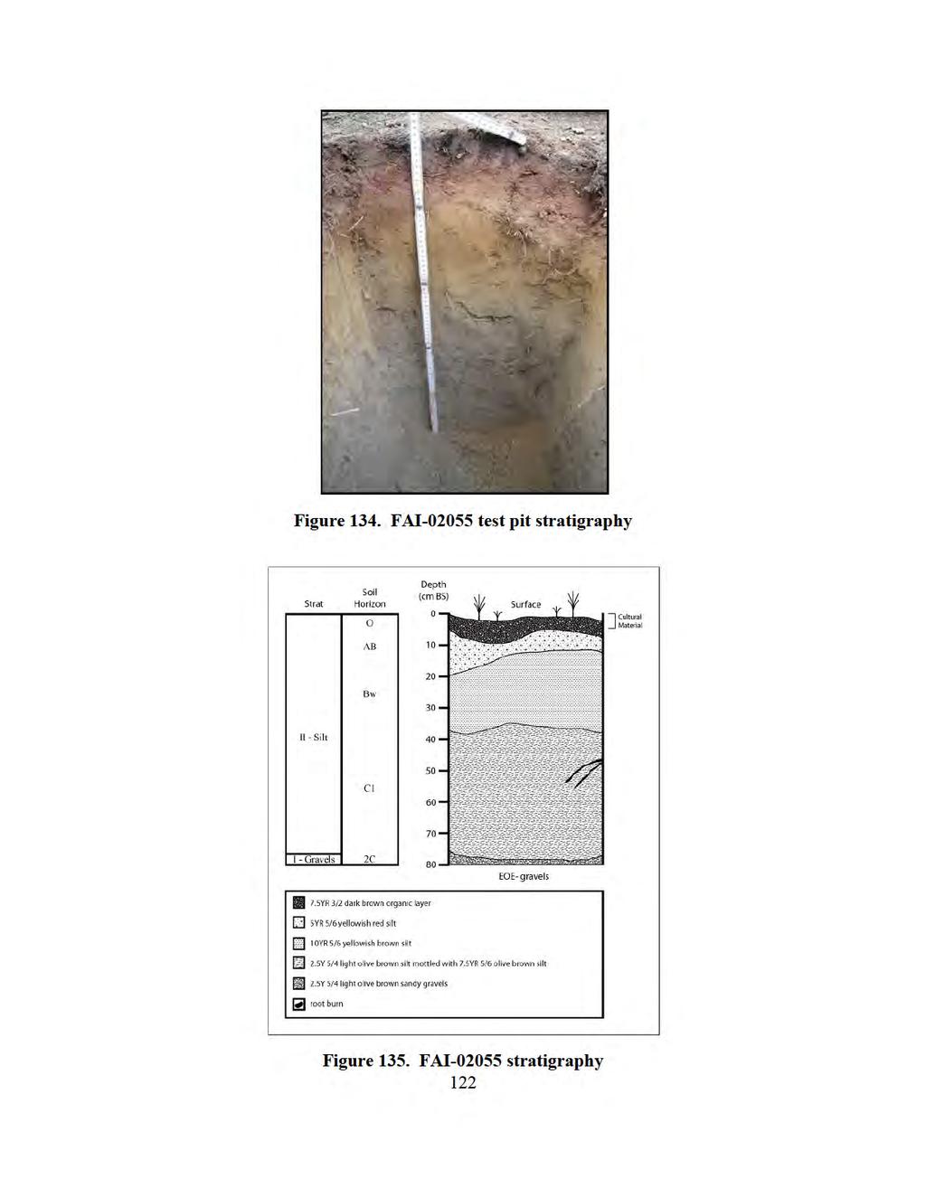
38 Figure 130. FAI stratigraphy FAI Latitude: Longitude: Determination of Eligibility: Not Evaluated Site FAI is located on a north-facing terrace edge approximately 2.5 km southwest of Dry Creek at UTM coordinates (Figure 131, Figure 132). Site elevation is 199 masl. The site is situated on an elevated rounded point extending roughly m in diameter. The sides of the knoll slope down to a small drainage 50 m north and east of the site, steeper to the east than to the north. The location of the site provides a viewshed of a nearby drainage to the east and limited views of the Dry Creek drainage to the north/northeast. Dry Creek is the nearest water source, and several unnamed, seasonal creeks cut through the outwash bench at closer locations. The ecosystem surrounding the site is characterized as upland moist mixed broadleaf/needleleaf forest (Figure 133). Site vegetation includes spruce, birch, aspen, willow, alder, and low shrubs. Ground cover at the site is minimal, but some areas have up to 30% surface exposure. An abandoned military foxhole is located 5 m north of the site. 119
39
40
41
42 FAI Latitude: Longitude: Determination of Eligibility: Not Evaluated Site FAI-2056 is located on a north-facing terrace edge some 2.5 km southwest of Dry Creek and less than 1 km east of the Clear Creek Assault Strip at UTM coordinates are (Figure 136, Figure 137). Site elevation is 208 masl. The site is situated on a low east-west trending terrace edge bordered by two elevated terraces to the east and west. Fifteen meters north of the site, the terrain slopes gradually (0-5 ) down to another terrace edge. South of the site, the terrain remains generally level for at least 50 m. The viewshed is significantly limited by vegetation and topography. Dry Creek is the nearest water source, and several unnamed, seasonal creeks cut through the outwash bench at closer locations. The ecosystem is characterized as upland moist mixed broadleaf/needleleaf forest (Figure 138). Site vegetation includes mixed age spruce, birch, scrub alder, willow, mosses, and lichen. There is minimal surface exposure in the site area. The site appears to be undisturbed, although there are a number of military foxholes in the vicinity. Site FAI was identified on the basis of a single dark reddish gray (10R 3/1) chert broken flake (UA ), size class mm, found within the exposed roots of a treefall (Figure 139). Soil in and around the roots was removed and screened, and 19 bone fragments were recovered. All of these are small fragments less than 10 cm in diameter. A single 50 cm x 50 cm test pit 15 m northeast of the treefall yielded no cultural material. Site stratigraphy consists of aeolian silt 48 cm thick overlying poorly sorted, sandy silt and gravel extending to a depth of 50 cm BS (Figure 139). 123
43
44
45
46 FAI Latitude: Longitude: Determination of Eligibility: Not Evaluated Site FAI is located on a north-facing terrace edge approximately 3 km southwest of Dry Creek at UTM coordinates (Figure 140, Figure 141). Site elevation is 215 masl. The site is situated on an elongated point that protrudes from the terrace and is situated between two north-south drainages. The site overlooks a large dry drainage running east-west, m north of the site. The terrain surrounding the site slopes down north, east, and west at approximately 5-10 to a secondary, lower terrace. Below this terrace, the slope increases to until it terminates in the drainages. South of the site, the terrain slopes gradually uphill for at least 50 m. The viewshed is limited to the dry drainage to the north. Dry Creek is the nearest water source, and several unnamed, seasonal creeks cut through the outwash bench at closer locations. The ecosystem is characterized as upland moist mixed broadleaf and needleleaf forest (Figure 142). Site vegetation includes spruce, birch, aspen, willow, alder, and low scrub. Surface exposure ranges from 0-30%. The site area is disturbed by two military foxholes and is littered by a can scatter and other military-related debris. Site FAI was identified through subsurface testing. Cultural material was recovered from one of four 50 cm x 50 cm test units, which yielded a single gray (7.5YR 5/1) chert flake fragment (UA ), size class mm, at cm BS. No tools were recovered from the site. Site stratigraphy consists of aeolian silt at least 50 cm thick overlying poorly sorted, silty gravel and/or sandy silt and gravel extending to at least 65 cm BS (Figure 143, Figure 144). 127
47
48
49
50
51
52
 Artifact Type n= Material Color UA2010-200-0001 1 surface flake fragment 1 rhyolite gray UA2010-200-0002 2B 0-10 broken flake 1 chert dark")
53 Table 15. FAI accession log UA Accession # FS # Depth (cm BS) Artifact Type n= Material Color UA surface flake fragment 1 rhyolite gray UA B 0-10 broken flake 1 chert dark gray UA bone 3 UA charcoal UA flake fragment 1 rhyolite dark gray UA A 8 broken flake 1 chert light gray UA A 0-10 microblade fragment 1 rhyolite light brown UA B 8 charcoal UA Accession # L (mm) Table 16. FAI microblade attributes W (mm) T (mm) # of Arrises Segment Retouch Material Color UA medial no rhyolite light brown Munsell Code 7.5YR 6/3 Figure 148. FAI microblade 134
54
55 FAI Latitude: Longitude: Determination of Eligibility: Not Evaluated Site FAI is located on the upper of three stepped terraces overlooking a large, south-north drainage to the east and the Tanana River Valley to the north (Figure 151, Figure 152). UTM coordinates for the site are. Site elevation is 202 masl. The site is situated on a level area near the eastern edge of the terrace. The terrace drops at a 5-15 slope to the north, east, and west. South of the site, the terrace roughly parallels the eastern drainage at a slightly lower elevation. The location of the site provides an excellent viewshed of the eastern drainage and the Tanana River Valley to the north. Dry Creek is the nearest water source, although several unnamed seasonal creeks cut through the outwash bench at closer locations. The ecosystem is characterized as upland moist mixed needleleaf forest (Figure 153). The terrace is thickly wooded with small spruce trees except on the terrace edge, where the ground surface is bare dirt and gravel, void of any ground cover and prone to erosion. Site vegetation is primarily low thick spruce trees with a sparse understory of alder, willow, mosses, and lichen. Site FAI was located through subsurface testing. Cultural material was recovered from one of three 50 cm x 50 cm test units excavated. In total, 42 artifacts were recovered at depths of 0-45 cm BS. These artifacts include 39 pieces of debitage (Table 17), two biface fragments (Table 18, Figure 154), one complete endscraper (Table 19, Figure 155), and one tested cobble (Table 20). Site stratigraphy consists of aeolian silts at least 70 cm thick containing intermittent bands and pockets of sand, overlying poorly sorted silty gravels extending to at least 80 cm BS (Figure 156, Figure 157). 136
56
57
58 Table 17. FAI accession log UA Accession # FS # Depth (cm BS) Artifact Type n= Material Color UA flake 1 chert very dark gray UA flake 1 rhyolite pale brown UA A flake fragment 1 chert very dark gray UA flake and flake fragment 9 chert, basalt & rhyolite various UA flake fragment 1 basalt black UA flake 1 chert very dark gray UA flake fragment 1 chert very dark gray UA flake fragment 2 chert very dark gray UA flake and flake fragment 2 chert dark gray UA flake and flake fragment 4 chert dark gray UA flake and flake fragment 4 chert dark gray UA flake and flake fragment 2 chert dark gray UA flake 2 chert dark gray UA flake 1 basalt dark gray UA flake and flake fragment 3 chert dark gray UA flake and flake fragment 3 chert dark gray UA flake fragment 1 chert gray Table 18. FAI biface attributes UA Accession # FS # Depth (cm BS) Material Color L(mm) W(mm) T(mm) UA chert dark gray UA B basalt black Table 19. FAI endscraper attributes Retouch Length (mm) UA Accession # FS # Depth A (left B C (right D Material Color L(mm) W(mm) (cm BS) lat.) (dist.) lat.) (prox.) UA C rhyolite mottled Table 20. FAI cobble attributes UA Accession # FS # Depth (cm BS) Material Color Shape L(mm) W(mm) T(mm) UA grano-diorite greenish gray rounded


59 Figure 153. FAI bifaces Figure 154. FAI endscraper 140
60
61
62
63
 UA2010-202-0002 2 0-10 flake and flake fragment 2 rhyolite and basalt grayish brown and very dark gray")
64 Figure 160. FAI retouched flake Table 22. FAI accession log FS Depth UA Accession # Artifact Type n= Material Color # (cm BS) UA flake and flake fragment 2 rhyolite and basalt grayish brown and very dark gray UA flake fragment 1 rhyolite very dark gray, yellowish brown UA charcoal #1 UA charcoal #2 UA charcoal #3 UA flake fragment 2 rhyolite and chert light gray and light brownish gray UA flake and flake fragment 5 rhyolite and chert various UA flake and flake fragment 4 rhyolite gray and light brownish gray UA flake and flake fragment 10 chert very dark gray UA flake fragment 1 chert dark gray UA flake and flake fragment 7 chert dark gray UA soil sample UA flake and flake fragment 2 chert dark gray 145


65 Figure 161. FAI test pit stratigraphy Figure 162. FAI stratigraphy 146
66
67

68

69 Figure 166. FAI stratigraphy FAI Latitude: Longitude: Determination of Eligibility: Not Evaluated Site FAI is located on a north-facing terrace edge approximately 3 km southwest of Dry Creek and about 1 km southeast of the Clear Creek Assault Strip at UTM coordinates (Figure 168, Figure 169). Site elevation is 202 masl. The site is situated on small, level knoll 2-4 m in diameter overlooking a south-north drainage lying to the east. The site area has a 0-5 slope. The sides of the knoll slope down in all directions. The location of the site provides an excellent 180 viewshed of a large drainage to the east and a limited view of the Tanana River Valley to the north. The ecosystem surrounding the site is characterized as upland moist mixed broadleaf/needleleaf forest (Figure 170). Site vegetation consists of spruce, birch, aspen, willow, alder, and low 150

70
71
72
73
74
75
 Artifact Type n= Material Color UA2010-205-0001 1 35-50 flake and flake fragment 8 chert various UA2010-205-0002 2 40 flake 1 chert dark gray")
76 Table 25. FAI accession log UA Accession # FS # Depth (cm BS) Artifact Type n= Material Color UA flake and flake fragment 8 chert various UA flake 1 chert dark gray UA flake 1 chert black UA flake fragment 1 chert dark gray Table 26. FAI biface attributes UA Accession # FS # Depth (cm BS) Material Color L (mm) W (mm) T(mm) UA chert dark gray Figure 175. FAI projectile point fragment 157
77
78
79
80
81 Table 27. FAI accession log UA Accession # FS # Depth (cm BS) Artifact Type n= Material Color UA flake fragment 2 rhyolite various UA flake and flake fragment 18 chert and rhyolite various UA flake fragment 1 rhyolite very pale brown UA flake and flake fragment 5 chert and rhyolite various UA flake fragment 5 chert and rhyolite various UA flake 1 rhyolite light yellowish brown UA flake fragment 1 rhyolite light brown UA charcoal UA flake fragment 1 chert black UA flake 1 rhyolite light brown UA charcoal UA A 35 flake fragment 2 rhyolite various UA A flake and fragment 5 chert and rhyolite various UA flake fragment 2 rhyolite light brown UA flake 1 chert dark gray UA charcoal UA flake and flake fragment 6 chert and rhyolite various UA flake and flake fragment 12 chert and rhyolite various UA flake fragment 5 chert and rhyolite various UA flake and flake fragment 3 chert and rhyolite various UA B flake 1 obsidian clear Table 28. FAI microblade attributes UA Accession # FS # Depth Material Color L(mm) W(mm) T(mm) # of (cm BS) Arises Segment UA chert brown medial UA chert dusky red proximal Figure 181. FAI microblades 162
 Material Color L(mm) W(mm) T(mm) UA2010-206-0022 12B 35 chert light")
82 Table 29. FAI burin attributes UA Accession # FS # Depth (cm BS) Material Color L(mm) W(mm) T(mm) UA B 35 chert light brownish gray Figure 182. FAI burin spall Figure 183. FAI test pit BT79 stratigraphy (view to south) 163
83
84
85

86
87
88
89 Table 32. FAI accession log UA Accession # FS # Depth (cm BS) Artifact Type n= Material Color UA flake and flake fragment 70 chert various UA flake fragment 1 chert dark reddish gray UA flake fragment 1 chert dark gray UA flake fragment 2 chert dark gray UA flake and flake fragment 3 chert very dark gray and dark gray UA flake fragment 1 chert dark gray UA charcoal UA flake 1 chert dark gray UA flake fragment 1 chert dark gray UA flake and flake fragment 4 chert dark gray UA flake 2 chert dark gray UA flake 1 chert dark gray UA flake fragment 1 chert dark gray Table 33. FAI biface attributes Depth UA Accession # FS # Material Color L(mm) W(mm) T(mm) (cm BS) UA (1 of 2)* 5A 9-33 chert grayish brown UA (2 0f 2) 5B 0-33 *2 heat fractured fragments refit and analyzed as one artifact (originally recovered separately) 170


90 Figure 192. FAI biface Table 34. FAI microblade attributes FS Depth # of UA Accession # Material Color L(mm) W(mm) T(mm) Segment # (cm BS) Arises UA chert black proximal Figure 193. FAI microblade 171
91
92
93
94
95
96
97
98
99
100
Figure 66. FAI site overview.
 Figure 66. FAI-02246 site overview. FAI-02247 Latitude: Longitude: UTM: Determination of Eligibility: Not evaluated FAI-02247 is located on a high point where the northern branch of the Blair Lakes ridge
 Figure 343. FAI-02094 stratigraphy FAI-02097 Latitude: Longitude: Determination of Eligibility: not evaluated Site FAI-02097 is located on a low stabilized dune in the relatively featureless expanse of
December 13, Kirk Shields Green Mountain Power 163 Acorn Lane Colchester, VT 05446
 December 13, 2017 Kirk Shields Green Mountain Power 163 Acorn Lane Colchester, VT 05446 RE: End of Field Letter for Archaeological Phase II Site Evaluation at Site VT-CH-1218 within the Proposed Milton
DETAILED DESCRIPTION OF STREAM CONDITIONS AND HABITAT TYPES IN REACH 4, REACH 5 AND REACH 6.
 DETAILED DESCRIPTION OF STREAM CONDITIONS AND HABITAT TYPES IN REACH 4, REACH 5 AND REACH 6. The Eklutna River was divided into study reaches (figure 1) prior to this site visit. Prominent geologic or
THE CROOKS GAP HOUSEPIT SITE AND OTHER NEARBY MID-HOLOCENE HOUSEPITS
 Volume 56(1 ), Spring 2012 The Wyoming Archaeologist THE CROOKS GAP HOUSEPIT SITE AND OTHER NEARBY MID-HOLOCENE HOUSEPITS by Craig S. Smith Marcia Peterson INTRODUCTION This article summarizes excavation
AN ARCHAEOLOGICAL SURVEY FOR THE EASTHAM STATE PRISON FARM UNIT PROJECT IN HOUSTON COUNTY TEXAS
 AN ARCHAEOLOGICAL SURVEY FOR THE EASTHAM STATE PRISON FARM UNIT PROJECT IN HOUSTON COUNTY TEXAS Antiquities Permit 5693 By William E. Moore and Edward P. Baxter Brazos Valley Research Associates Contract
SUPPLEMENTAL MATERIAL
 SUPPLEMENTAL MATERIAL DESCRIPTIONS OF OTHER STRATIGRAPHIC SECTIONS Cherry Creek In its middle reaches, Cherry Creek meanders between three paired terraces within a narrow bedrock valley. The highest is
3.2.2 Ecological units of the Des Quinze lake proposed biodiversity reserve
 3.2.2 Ecological units of the proposed biodiversity reserve An intact forest mass The proposed biodiversity reserve (see appendix 3) protects terrestrial environments almost exclusively. Proximity of Des
Monitoring and modelling hydrological fluxes in support of nutrient cycling studies in Amazonian rain forest ecosystems Tobon-Marin, C.
 UvA-DARE (Digital Academic Repository) Monitoring and modelling hydrological fluxes in support of nutrient cycling studies in Amazonian rain forest ecosystems Tobon-Marin, C. Link to publication Citation
APPENDIX C HYDROGEOLOGIC INVESTIGATION
 Figure B-5.7 Figure B-5.8 Preliminary Geotechnical and Environmental Report Appendix C Hydrogeologic Investigation APPENDIX C HYDROGEOLOGIC INVESTIGATION December 21, 2011 WESTSIDE SUBWAY EXTENSION PROJECT
Lowest and Youngest Terrace : Soil Pit #4
 Lowest and Youngest Terrace : Soil Pit #4 Observations : Where : Huntington Terraces Climate : Cloudy, mid 60 s Our soil pit was the lowest of the 4 sites The pit site was located on the right side of
Preliminary soil survey of the NATL Old Field Plots
 Preliminary soil survey of the NATL Old Field Plots The preliminary soil survey consisted of completing auger borings at 25 m intervals and included auger borings at total of 46 points. The borings were
CHAPTER 4. Blue Heron Site (47Je1001) 2003 Investigations. By Chrisie L. Hunter
 2003 Investigations. By Chrisie L. Hunter") CHAPTER 4 Blue Heron Site (47Je1001) 2003 Investigations By Chrisie L. Hunter Introduction The Blue Heron site (47Je1001) is on the property of the Crescent Bay Hunt Club, which is located in the NE 1/4
CHAPTER 4 Blue Heron Site (47Je1001) 2003 Investigations By Chrisie L. Hunter Introduction The Blue Heron site (47Je1001) is on the property of the Crescent Bay Hunt Club, which is located in the NE 1/4
Clyde River Landslide
 Clyde River Landslide Department of Geology, Perkins Hall, University of Vermont, Burlington, VT 05405 Abstract: This paper investigates a landslide on the Clyde River in Newport, Vermont. The landslide
 TP-1 N61E 0 DARK BROWN SANDY SILT (ML) stiff, wet with roots (Disturbed Surficial Soil) DEPTH (FEET) 5 REDDISH BROWN SANDSTONE intensely fractured, weak to friable, deeply weathered, tight (Franciscan
The Upper Paleolithic Longwangcan Site at Yichuan in Shaanxi
 The Upper Paleolithic Longwangcan Site at Yichuan in Shaanxi The Institute of Archaeology, Chinese Academy of Social Sciences Shaanxi Provincial Institute of Archaeology Key words: Longwangcan site; microliths;
Hydro One (Sept 2014) Hydro One (Sept 2014) Hydro One (Sept 2014)
 Hydro One (Sept 2014) Hydro One (Sept 2014)") TABLE 1 WELL CONSTRUCTION DETAILS MOE WWR No Well ID Location Installation Date Status Easting Coordinates Northing Source Elevation Screened Interval Screened Material Borehole Well Stick-up Ground Top
TABLE 1 WELL CONSTRUCTION DETAILS MOE WWR No Well ID Location Installation Date Status Easting Coordinates Northing Source Elevation Screened Interval Screened Material Borehole Well Stick-up Ground Top
Figure DR3. Constraints on the depth of the hiatus surface based on 10 Be concentration of middle core sample.
 GSA Data Repository Item 2018099 Del Vecchio, J., DiBiase, R.A., Denn, A.R., Bierman, P.R., Caffee, M.W., and Zimmerman, S.R., 2018, Record of coupled hillslope and channel response to Pleistocene erosion
Log of Monitoring Well D58B
 Project: Motiva - Monitoring Well and Soil Boring Data Project Location: Delaware City Refinery Project Number: 20240412.W1000 Log of Monitoring Well D58B Sheet 1 of 7 Date(s) Drilled Drilling Method Drill
Waterbury Dam Disturbance Mike Fitzgerald Devin Rowland
 Waterbury Dam Disturbance Mike Fitzgerald Devin Rowland Abstract The Waterbury Dam was completed in October 1938 as a method of flood control in the Winooski Valley. The construction began in April1935
DATE: 5/17/2012. LOGGED BY: Geoff Richards. COMPANY: Tetra Tech EM, Inc. DRILL FOREMAN: Walter
 ATTACHMENT 2 Page 1 of 1 B1 0 1 2 FILL, Dry; brownish red; clayey silt and gravel; ~30% gravel size fragments of dark grey microcrystalline (aphanetic), extrusive, igneous, rock 3 B1-4a 1100 B1-4b-duplicate
Starting at Rock Bottom
 Starting at Rock Bottom At rock bottom of the Brushy Creek site s geological column lies the first clue to human habitation: A smelting and heattreating furnace, and mold, carved into Bed Ked: Figure 15
ODFW AQUATIC INVENTORY PROJECT RESTORATION MONITORING STREAM HABITAT REPORT. Peggy Kavanagh, Trevan Cornwell TOLEDO SOUTH Coast Range Lora Tennant
 ODFW AQUATIC INVENTORY PROJECT RESTORATION MONITORING STREAM HABITAT REPORT STREAM: GCG: 2-MC SITE ID: 489 BASIN: YAQUINA TREATMENT DATE: 24 SURVEY DATE: 2/27/24 SURVEY CREW: USGS MAPS: ECOREGION: REPORT
Midterm Review. Nata/Lee
 Name: 1. Which statement best supports the theory that all the continents were once a single landmass? (1) Rocks of the ocean ridges are older than those of the adjacent sea floor. (2) Rock and fossil
UAS Student Residence
 General Notes, Abbreviations and Symbols C100 MATCH LINE - SEE SHEET L6 Existing Site Topographic Conditions C101 MATCH LINE - SEE SHEET L5 Existing Site Topographic Conditions C102 DEPTH(FT.) 5 FROZEN
Feet. SAND; clayey, fine grained; shells are common; rounded quartz grains. SHELLS; muddy; almost no sand, shells and fragments common
 SAND; clayey, fine grained; shells are common; rounded quartz grains SHELLS; muddy; almost no sand, shells and fragments common SAND; back to medium to fine; has a mottled appearance and looks burrowed;
Archaeological Survey and Evaluation at 8954 El Dorado Parkway, El Cajon, San Diego County, California
 April 16, 2013 Ms. Andrea Bitterling Helix Environmental Planning, Inc. 7578 El Cajon Blvd., Suite 200 El Cajon, California 91942 Re: Archaeological Survey and Evaluation at 8954 El Dorado Parkway, El
Depth (ft) USCS Soil Description TOPSOIL & FOREST DUFF
 USCS Soil Description TOPSOIL & FOREST DUFF") Test Pit No. TP-6 Location: Latitude 47.543003, Longitude -121.980441 Approximate Ground Surface Elevation: 1,132 feet Depth (ft) USCS Soil Description 0 1.5 1.5 5.0 SM 5.0 8.0 SM Loose to medium dense,
Test Pit No. TP-6 Location: Latitude 47.543003, Longitude -121.980441 Approximate Ground Surface Elevation: 1,132 feet Depth (ft) USCS Soil Description 0 1.5 1.5 5.0 SM 5.0 8.0 SM Loose to medium dense,
THE MINISTRY OF ENERGY AND ENERGY INDUSTRIES MINERALS DIVISION MINE DESIGN TEMPLATE OPERATOR NAME: OPERATOR ADDRESS: PHONE NUMBER: FACSIMILE:
 THE MINISTRY OF ENERGY AND ENERGY INDUSTRIES MINERALS DIVISION MINE DESIGN TEMPLATE 1.0 GENERAL INFORMATION OPERATOR NAME: OPERATOR ADDRESS: PHONE NUMBER: FACSIMILE: NAME OF CONTACT: CELLULAR PHONE: EMAIL
Converse Consultants Geotechnical Engineering, Environmental & Groundwater Science, Inspection & Testing Services
 Converse Consultants Geotechnical Engineering, Environmental & Groundwater Science, Inspection & Testing Services July 27, 2017 Ms. Rebecca Mitchell Mt. San Antonio College Facilities Planning & Management
Soils of the GLBRC Marginal Land Experiment (MLE) Sites
 Sites") KBS LTER Special Publication Soils of the GLBR Marginal Land Experiment (MLE) Sites. S. Kasmerchak and R. Schaetzl Department of Geography, Environmental, and Spatial Sciences Michigan State University
KBS LTER Special Publication Soils of the GLBR Marginal Land Experiment (MLE) Sites. S. Kasmerchak and R. Schaetzl Department of Geography, Environmental, and Spatial Sciences Michigan State University
New York University Excavations at Amheida 2010 Geological Investigations LOCAL GEOLOGY
 New York University Excavations at Amheida 2010 Geological Investigations LOCAL GEOLOGY The geology of the Amheida area has been outlined previously by the site topographers; the general geomorphology
On-Site Soils Investigation. Buttermilk Way Storm water Treatment Project Buzzards Bay. MA. February 28 th, 2012
 1 On-Site Soils Investigation Buttermilk Way Storm water Treatment Project Buzzards Bay. MA February 28 th, 2012 Glenn Stanisewski, Resource Soil Scientist, USDA-NRCS, West Wareham, MA Introduction: The
Regional Geomorphology
 Chapter 2 Environmental Setting Regional Geomorphology The study area is set in the floodplain of the Mississippi River, just south of Plaquemine, Louisiana. The river has occupied its current position
3.12 Geology and Topography Affected Environment
 3 Affected Environment and Environmental Consequences 3.12 Geology and Topography 3.12.1 Affected Environment 3.12.1.1 Earthquakes Sterling Highway MP 45 60 Project Draft SEIS The Kenai Peninsula is predisposed
Observations on Surface Water in the Seminary Fen in Spring, Prepared 6/4/13 by Sam Wetterlin; updated 7/28/13
 Observations on Surface Water in the Seminary Fen in Spring, 2013 Prepared 6/4/13 by Sam Wetterlin; updated 7/28/13 Ordinarily, a calcareous fen is primarily dependent on upwelling mineral-rich, oxygen-poor
MILITARY TOPOGRAPHIC MAP II B170247XQ STUDENT HANDOUT
 UNITED STATES MARINE CORPS THE BASIC SCHOOL MARINE CORPS TRAINING COMMAND CAMP BARRETT, VIRGINIA 22134-5019 MILITARY TOPOGRAPHIC MAP II B170247XQ STUDENT HANDOUT Basic Officer Course Introduction Importance
Date Submitted: June General Nature of Report: Examination of Placer Samples
 General Nature of Report: Examination of Placer Samples Claim: Gold Channel, Record Number 3775!8 1 (Gold Channel Placer Property) Mining Division: Cariboo NTS 093 G 09 W and E Latitude 520 23 N' Longitude1210
Correlation of gravel deposits from trenching project on Alder Creek fluvial terrace near Point Arena, California
 Correlation of gravel deposits from trenching project on Alder Creek fluvial terrace near Point Arena, California Aletha Lee Department of Geology and Geography, West Virginia University, White Hall, Morgantown,
 UNIT DESCRIPTIONS: Artificial Fill, Undocumented (Afu): Locally derived sandy silt and silty sand, locally with clay and varying amounts of gravel and man-made debris. Abundant concrete rubble, in places
Ecology 312 SI STEVEN F. Last Session: Aquatic Biomes, Review This Session: Plate Tectonics, Lecture Quiz 2
 Ecology 312 SI STEVEN F. Last Session: Aquatic Biomes, Review This Session: Plate Tectonics, Lecture Quiz 2 Questions? Warm up: KWL KNOW: On a piece of paper, write down things that you know well enough
Pratice Surface Processes Test
 1. The cross section below shows the movement of wind-driven sand particles that strike a partly exposed basalt cobble located at the surface of a windy desert. Which cross section best represents the
Four Beetles Project Mendocino National Forest
 Four Beetles Project Mendocino National Forest Jose Chavez Bakersfield College 06/07/2016-08/02/2016 District Archeologist Curtis Fair & District Hydrologist John Kelley 2016 Acknowledgements: This project
Correlation of Tills Exposed in Toledo Edison Dam Cut, Ohio
 The Ohio State University Knowledge Bank kb.osu.edu Ohio Journal of Science (Ohio Academy of Science) Ohio Journal of Science: Volume 60, Issue 2 (March, 1960) 1960-03 Correlation of Tills Exposed in Toledo
List of Sites in District 2C Source Number
 List of Sites in District 2C Source Number 03-002-1...2 03-021-1...4 03-070-1...6 14-002-1...8 14-007-1...10 14-011-1...12 14-015-1...14 26-004-1...16 26-007-1...18 26-010-1...20 26-013-1...22 26-036-1...24
The Upper Palaeolithic of North China Chaisi Locality 7701
 The Upper Palaeolithic of North China Chaisi Locality 7701 Tang Chung Centre for Chinese Archaeology and Art The Chinese University of Hong Kong 1 LOCATION The site of Chaisi is located at the bank of
BURIED SOILS OF GLOBE HILL, UPPER OHIO VALLEY
 BURIED SOILS OF GLOBE HILL, UPPER OHIO VALLEY HEBER D. LESSIG Soil Scientist, Box 248, Lisbon, Ohio A terrace, 5 mi downstream from Wellsville, Ohio, standing about 200 ft above the Ohio River, was recently
Prehistory and History of Squaw Creek, Powder River Basin, Wyoming
 Prehistory and History of Squaw Creek, Powder River Basin, Wyoming Mavis Greer, Ph.D. and John Greer, Ph.D. Paper Presented at the 53 rd Annual Meeting of the Wyoming Archaeological Society Cheyenne, Wyoming
Parent Materials. & some of Seattle s soils
 Parent Material & some of Seattle s soils ESRM 311/SEFS 507 Week 3 SOILS = f(cl, r, o, p, t) Parent Materials 1) Sedentary a) residual (bedrock weathered in place) b) organic 2) Transported by a) gravity
A Phase I Archaeological Survey of Muir Knoll, University of Wisconsin-Madison, Dane County, Wisconsin
 A Phase I Archaeological Survey of Muir Knoll, University of Wisconsin-Madison, Dane County, Wisconsin Prepared For: The University of Wisconsin-Madison Prepared By: Amy L. Rosebrough Office of the State
SOIL: DEFINITION, FORMATION! & LAYERS"
 SOIL: DEFINITION, FORMATION & LAYERS" What Is Soil? soil - upper-most (relatively thin) layer of Earth s crust, which supports terrestrial plants, animals, & microorganisms basic natural resource that
Unit 3 Review - Surface Processes
 Unit 3 Review - Surface Processes 1. Why is the surface of Mercury covered with meteor impact craters, while Earth s surface has relatively few craters? A) Mercury is larger than Earth, so it gets hit
depression above scarp scarp
 1 LAB 1: FIELD TRIP TO McKINLEYVILLE AND MOUTH OF THE MAD RIVER OBJECTIVES: a. to look at geomorphic and geologic evidence for large scale thrust-faulting of young sediments in the Humboldt Bay region
We recommend you cite the published version. The publisher s URL is
 Bridle, A. (2012) The mid-to-late pleistocene palaeos of the Gordano Valley, North Somerset. PhD, University of the West of England. We recommend you cite the published version. The publisher s URL is
TEXTURE ANALYSIS. Unknown 1 Unknown 2. Unknown 3 6O 6O O Z 14X 10Z X X 8Z
 Unknown 1 Unknown 2 TEXTURE ANALYSIS Unknown 3 O 2O 10Z X X 8Z O 2X O Z 14X X 2O 6O 6O Parent Material & some of Seattle s soils ESRM 311/SEFS 507 Week 3 SOILS = f(cl, r, o, p, t) Parent Materials 1) Sedentary
Global Biogeography. Natural Vegetation. Structure and Life-Forms of Plants. Terrestrial Ecosystems-The Biomes
 Global Biogeography Natural Vegetation Structure and Life-Forms of Plants Terrestrial Ecosystems-The Biomes Natural Vegetation natural vegetation is the plant cover that develops with little or no human
Name: Which rock layers appear to be most resistant to weathering? A) A, C, and E B) B and D
 A, C, and E B) B and D") Name: 1) The formation of soil is primarily the result of A) stream deposition and runoff B) precipitation and wind erosion C) stream erosion and mass movement D) weathering and biological activity 2)
Name: 1) The formation of soil is primarily the result of A) stream deposition and runoff B) precipitation and wind erosion C) stream erosion and mass movement D) weathering and biological activity 2)
The Cassiar Mountains
 The Cassiar Mountains Introduction Topography Dease Plateau Dease Lake, BC Stikine Ranges Eve Cone Mount Edziza Provincial Park Mount Ash, BC 2 125m Ketchika Ranges Muskwa- Ketchika Management Area Sifton
PARQUE COLON AGUADILLA (LAND PROPERTY OF MUNICIPIO AGUADA) LOT PROPERTY OF SUNC. ESTEVEZ BW-1 BW-5 BW-2 DB1 BW-3 DB2 BW-4 DB3 GWS-1
 LOT PROPERTY OF SUNC. ESTEVEZ BW-1 BW-5 BW-2 DB1 BW-3 DB2 BW-4 DB3 GWS-1") N 64650 N 64600 N 64550 N 64500 N 64450 N 64400 N 64350 N 64300 N 64250 N 64200 N 64150 N 64100 N 64050 N 64000 N 63950 N 63900 N 63850 N 63800 N 63750 N 63700 N 63650 N 63600 N 63550 N 63500 N 63450 N
N 64650 N 64600 N 64550 N 64500 N 64450 N 64400 N 64350 N 64300 N 64250 N 64200 N 64150 N 64100 N 64050 N 64000 N 63950 N 63900 N 63850 N 63800 N 63750 N 63700 N 63650 N 63600 N 63550 N 63500 N 63450 N
CASE STUDY #9 - Brushy Fork Dam, Sugar Grove, West Virginia
 CASE STUDY #9 - Brushy Fork Dam, Sugar Grove, West Virginia Brushy Fork Dam is a flood control structure built by the Soil Conservation Service southeast of the city of Franklin in Pendleton County, West
APPENDIX C. Borehole Data
 APPENDIX C Borehole Data MAJOR DIVISIONS SOIL CLASSIFICATION CHART SYMBOLS GRAPH LETTER TYPICAL DESCRIPTIONS ADDITIONAL MATERIAL
Geotechnical Report McCormick Pit
 Geotechnical Report McCormick Pit Part of Lot 12, Concession 2 EHS Town of Caledon, Region of Peel For Blueland Farms Limited February 2013 Prepared by Harrington McAvan Ltd 6882 14 th Avenue, Markham,
remain on the trees all year long) Example: Beaverlodge, Alberta, Canada
 Example: Beaverlodge, Alberta, Canada") Coniferous Forest Temperature: -40 C to 20 C, average summer temperature is 10 C Precipitation: 300 to 900 millimeters of rain per year Vegetation: Coniferous-evergreen trees (trees that produce cones
Coniferous Forest Temperature: -40 C to 20 C, average summer temperature is 10 C Precipitation: 300 to 900 millimeters of rain per year Vegetation: Coniferous-evergreen trees (trees that produce cones
Feet. Cape May Core #51 Start depth: 240 ft Stop depth: 245 ft Recovery (ft): 5.1 ft Date: 3/21/94 Described by: JVB, KGM, CL. 5.
: 5.1 ft Date: 3/21/94 Described by: JVB, KGM, CL. 5.") SAND; medium to fine sand with abundant silt, homogenous slightly mottled appearance; mica on outside, mostly quartz; few darks; peat layer.9 - ft; cnv - same as above; the last few cores are all the same;
SAND; medium to fine sand with abundant silt, homogenous slightly mottled appearance; mica on outside, mostly quartz; few darks; peat layer.9 - ft; cnv - same as above; the last few cores are all the same;
DRAFT SW ReGAP Vegetation Field Form
 SW ReGAP Vegetation Field Form Recorders Initials: Date: / 20 Plot ID: Mapping Zone: State: AZ CO NM UT UTM Zone: GPS: Y N UTM Easting: _ - - _ UTM Northing: - - _ % Error +/-: Datum: Site Confidence:
LANDFORM ANALYSIS AND SOIL RESOURCE INVENTORY USING REMOTE SENSING TECHNIQUE IN A WATERSHED OF UTTARANCHAL, INDIA
 LANDFORM ANALYSIS AND SOIL RESOURCE INVENTORY USING REMOTE SENSING TECHNIQUE IN A WATERSHED OF UTTARANCHAL, INDIA S.K.Mahapatra *, D. Martin, R.D.Sharma, S.P. Singh and J.P.Sharma National Bureau of Soil
Prehistoric Hunter-Gatherers in the Savage River Uplands, Denali National Park and Preserve
 20 Alaska Park Science, Volume 12, Issue 1 Prehistoric Hunter-Gatherers in the Savage River Uplands, Denali National Park and Preserve By John Blong Took a trip... down Savage River Trail. That trail is
Topographic Map Series:
 DEFINITION OF A MAP A MAP IS A GEOGRAPHIC PREPRESENTATION OF A PORTION OF THE EARTH S SURFACE DRAWN TO SCALE, AS SEEN FROM ABOVE. IT S USES COLORS, SYMBOLS AND LABELS TO REPRESENT FEATURES FOUND ON THE
The Lee River Landslide
 The Lee River Landslide Meghan O'Donnell Jon Bevan Geomorphology December 5, 2003 Abstract: Steep hillslopes that lie adjacent to active stream channels are prone to landsliding. Glaciolacustrine material
Evolution of the conceptual hydrogeologic and ground-water flow model for Las Vegas Valley, Clark County, Nevada
 Evolution of the conceptual hydrogeologic and ground-water flow model for Las Vegas Valley, Clark County, Nevada Geological Society of America Annual Meeting November 14, 2 David J. Donovan Southern Nevada
Using Map and Compass Together
 Using Map and Compass Together In situations where you foresee a potential evacuation on foot, where there are no roads, and no indication as to the direction of travel (i.e., road signs), it is recommended
 Page 1 of 9 Name: Base your answer to the question on the diagram below. The arrows show the direction in which sediment is being transported along the shoreline. A barrier beach has formed, creating a
2.2.7 Backbarrier flats
 FIGURE 24. VERTICAL PHOTOGRAPH SHOWING THE DEVELOPMENT OF SMALL PARABOLIC DUNES FROM BLOWOUTS IN A LARGE RELICT FOREDUNE NORTHWEST OF HUNTER'S CREEK. PHOTOGRAPH COURTESY OF CAR'T'ER HOLT HARVEY FORESTS
Using High-Resolution Airphotos for Assessing Landscape Change. Torre Jorgenson
 Using High-Resolution Airphotos for Assessing Landscape Change Torre Jorgenson It s All a Matter of Scale Landsat TM 28-m pixel Ikonos Fused 1-m pixel Digital Camera 0.2-m pixel Examples of Landscape
COMPOSITION OF AN ILLINOIAN-AGE GLACIAL KAME TERRACE IN THE BREMEN CREEK VALLEY FAIRFIELD COUNTY, OHIO
 COMPOSTON OF AN LLNOAN-AGE GLACAL KAME TERRACE N THE BREMEN CREEK VALLEY FARFELD COUNTY, OHO Senior Thesis--Completed in fulfillment of the requirements for the Bachelor of Science Degree at The Ohio State
Don Elsenheimer, Ph.D Glenn Melchert Minnesota Dept. Natural Resources
 Regional Survey of Gold in Till, Bigfork Greenstone Belt, St. Louis & Itasca Counties, Minnesota: Follow-up Trenching in Areas with Anomalously High Gold Grain Counts Don Elsenheimer, Ph.D Glenn Melchert
Prehistoric Clay Sources: A Forensic Exercise in Geoarchaeology
 Prehistoric Clay Sources: A Forensic Exercise in Geoarchaeology Lynn Ketterhagen Faculty Sponsor: Dean Wilder, Department of Geography and Earth Science ABSTRACT The prehistoric Oneota culture of the Upper
CANADA S LANDFORM REGIONS
 CANADA S LANDFORM REGIONS Canada s Regions Canada is divided into Eight major regions. A Region is an area that is defined on the basis of the presence or absence of certain characteristics: Age of rock
Kara-Bom: new investigations of a Palaeolithic site in the Gorny Altai, Russia
 Kara-Bom: new investigations of a Palaeolithic site in the Gorny Altai, Russia Natalia E. Belousova 1,2,, Evgeny P. Rybin 1,2, Alexander Yu. Fedorchenko 1,2 &AntonA.Аnoykin 1,2 New archaeological investigations
The Palmer Hill Glacial-Marine Delta, Whitefield, Maine
 Maine Geologic Facts and Localities December, 2010, Maine 44 o 10 12.16 N, 69 o 37 18.93 W Text by Woodrow Thompson, Department of Agriculture, Conservation & Forestry 1 Introduction The most recent continental
1. The map below shows a meandering river. A A' is the location of a cross section. The arrows show the direction of the river flow.
 1. The map below shows a meandering river. A A' is the location of a cross section. The arrows show the direction of the river flow. Which cross section best represents the shape of the river bottom at
Table 7.2. Summary of the magnetic anomalies scheduled for examination at the Long Tom site.
 The Long Tom and Chalker Sites 82 Figure 7.6. Magnetometer map of the central portion of the Long Tom site between 100W and 160W showing the location of trenches 124W and 145W excavated to examine magnetic
GEOLOGIC LOG Sand - orange-brown, slightly clayey; fine- to medium-grained, very well-sorted, subangular to subrounded; trace of feldspar
 OWNER: Fred W. Haislip DRILLER: Douglas & Dickinson, Inc. COUNTY: Northumberland (Burgess) Depth in feet GEOLOGIC LOG VDMR: WWCR: TOTAL DEPTH: 2000 140 673' COLUMBIA GROUP (0-42') 0-10 Sand - orange-brown,
 Photo 1 - Southerly view across 2700 parking lot toward existing building. Multi-residential building borders western side of property in upper right of view. Photo 2 - Southerly view across 2750 parking
SOUTH CERRO AZUL STRATIGRAPHIC SECTION. Upper Cerro Azul flow of the Servilleta Basalt (Tsbcau) Lower Sandlin unit (Tsl)
 Lower Sandlin unit (Tsl)") Figure A3-01 cobbles claysilt general grain size sand pebbles vf f m c vc SOUTH CERRO AZUL STRATIGRAPHIC SECTION Top at 18 m. Upper Cerro Azul flow of the Servilleta Basalt (Tsbcau) 15 Basalt: Very dark
Figure A3-01 cobbles claysilt general grain size sand pebbles vf f m c vc SOUTH CERRO AZUL STRATIGRAPHIC SECTION Top at 18 m. Upper Cerro Azul flow of the Servilleta Basalt (Tsbcau) 15 Basalt: Very dark
The discovery and excavation of a Mesolithic site in Daer Valley. Tam Ward December 2004
 The discovery and excavation of a Mesolithic site in Daer Valley. Tam Ward December 2004 Summary This report describes the discovery and excavation of a further Mesolithic site in the Daer Valley. Despite
3.18 GEOLOGY AND SOILS
 3.18 GEOLOGY AND SOILS This section discusses geologic resource concerns as they relate to the environment, public safety, and project design both during construction and after completion of the project.
Topographic Maps and Profiles
 Name: Date: Period: Earth Science Foundations The Physical Setting: Earth Science CLASS NOTES! Topographic Maps [contour maps] -! Topographic maps show three-dimensional shapes in two dimensions Elevation
1' U. S. Forest Products Laboratory. Weathering and decay. U.S. Forest Serv. Forest Prod. Lab. Tech. Note 221 (rev,), 2 pp. 1956, (Processed.
, 2 pp. 1956, (Processed.") Number 171 Portland, Oregon August 1959 EFFECT OF WEATHERING ON ACCURACY OF FUEL-MOISTURE-INDICATOR STICKS IN THE PACIFIC NORTHWEST by William Go Morris How much does weathering affect accuracy of fuel-moistureindicator
Number 171 Portland, Oregon August 1959 EFFECT OF WEATHERING ON ACCURACY OF FUEL-MOISTURE-INDICATOR STICKS IN THE PACIFIC NORTHWEST by William Go Morris How much does weathering affect accuracy of fuel-moistureindicator
Mass Wasting. Revisit: Erosion, Transportation, and Deposition
 Mass Wasting Revisit: Erosion, Transportation, and Deposition While landslides are a normal part of erosion and surface processes, they can be very destructive to life and property! - Mass wasting: downslope
Appendix 7A. Cultural Resources Documentation
 Appendix 7A Cultural Resources Documentation October 5, 2009 Mr. Douglas P. Mackey Historic Preservation Program Analyst, Archaeology New York State Office of Parks, Recreation and Historic Preservation
Laboratory Exercise #4 Geologic Surface Processes in Dry Lands
 Page - 1 Laboratory Exercise #4 Geologic Surface Processes in Dry Lands Section A Overview of Lands with Dry Climates The definition of a dry climate is tied to an understanding of the hydrologic cycle
Biosphere. All living things, plants, animals, (even you!) are part of the zone of the earth called the biosphere.
 are part of the zone of the earth called the biosphere.") Unit 1 Study Guide Earth s Spheres Biosphere All living things, plants, animals, (even you!) are part of the zone of the earth called the biosphere. Hydrosphere Water covers ¾ of the earth, made up mostly
Unit 1 Study Guide Earth s Spheres Biosphere All living things, plants, animals, (even you!) are part of the zone of the earth called the biosphere. Hydrosphere Water covers ¾ of the earth, made up mostly
Gregory L. Fox, PhD. U.S. Army Central Identification Laboratory 310 Worchester Avenue Hickam AFB, HI October 2002
 Search and Recovery Report 2002/CIL/069, Recovery Scene KN-0885, a Secondary and Primary Burial Recovery Scene in Shin- Hungri Village, Changjin District, South Hamkyong Province, Democratic People s Republic
A journey through the earth history of Australia s Coastal Wilderness Part 3 The backdrop - a 70 million year old plain
 A journey through the earth history of Australia s Coastal Wilderness Part 3 The backdrop - a 70 million year old plain Monaro Plain 3. The Cretaceous Plain The western horizon behind Moruya is dominated
SOIL INFORMATION FOR PUMPED WATER STORAGE SCHEME, STEELPOORT VALLEY
 REPORT On contract research for Bohlweki Environmental SOIL INFORMATION FOR PUMPED WATER STORAGE SCHEME, STEELPOORT VALLEY February 2007 By D.G. Paterson ARC-Institute for Soil, Climate and Water, Private
The elevations on the interior plateau generally vary between 300 and 650 meters with
 11 2. HYDROLOGICAL SETTING 2.1 Physical Features and Relief Labrador is bounded in the east by the Labrador Sea (Atlantic Ocean), in the west by the watershed divide, and in the south, for the most part,
KANSAS GEOLOGICAL SURVEY Open File Report LAND SUBSIDENCE KIOWA COUNTY, KANSAS. May 2, 2007
 KANSAS GEOLOGICAL SURVEY Open File Report 2007-22 LAND SUBSIDENCE KIOWA COUNTY, KANSAS Prepared by Michael T. Dealy L.G., Manager, Wichita Operations SITE LOCATION The site was approximately four miles
Archaeological Survey and Assessment of Four Wastewater Interceptor Routes in Garner, Wake Co., N.C. (EPA C )
") Archaeological Survey and Assessment of Four Wastewater Interceptor Routes in Garner, Wake Co., N.C. (EPA C370623-02) By H. Trawick \vard R. P. Stephen Davis Prepared by the Research Laboratories of Anthropology
Archaeological Survey and Assessment of Four Wastewater Interceptor Routes in Garner, Wake Co., N.C. (EPA C370623-02) By H. Trawick \vard R. P. Stephen Davis Prepared by the Research Laboratories of Anthropology
CHAPTER 12 Archaeological Survey at Quinney Farm and Papcke Fields, Walworth County by Jocelyn Boor, Kira Kaufmann, Robert J.
 CHAPTER 12 Archaeological Survey at Quinney Farm and Papcke Fields, Walworth County by Jocelyn Boor, Kira Kaufmann, Robert J. Jeske The 2000 University of Wisconsin-Milwaukee Field School conducted an