TEXTURE ANALYSIS. Unknown 1 Unknown 2. Unknown 3 6O 6O O Z 14X 10Z X X 8Z
|
|
|
- Nigel Porter
- 5 years ago
- Views:
Transcription
1 Unknown 1 Unknown 2 TEXTURE ANALYSIS Unknown 3 O 2O 10Z X X 8Z O 2X O Z 14X X 2O 6O 6O
2 Parent Material & some of Seattle s soils ESRM 311/SEFS 507 Week 3
 water - alluvial - marine - lacustrine c) ice - glacial - outwash - till d) wind (eolian) - sand dunes (coarse) - loess (silt, vfs) - volcanic")
3 SOILS = f(cl, r, o, p, t) Parent Materials 1) Sedentary a) residual (bedrock weathered in place) b) organic 2) Transported by a) gravity - colluvial b) water - alluvial - marine - lacustrine c) ice - glacial - outwash - till d) wind (eolian) - sand dunes (coarse) - loess (silt, vfs) - volcanic (ash) 3
4 4
5 5
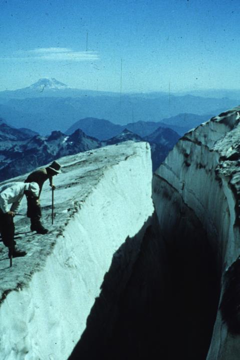
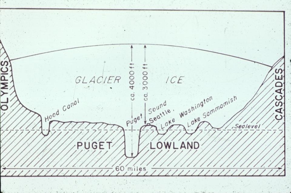
6 6
7 7

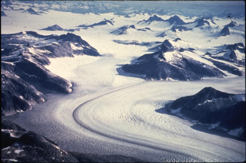
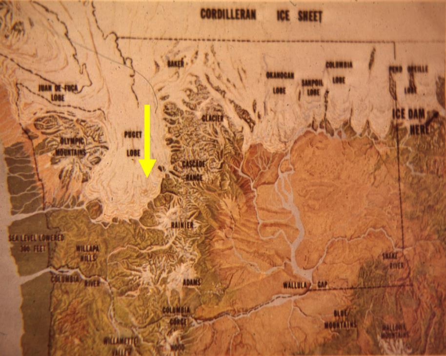
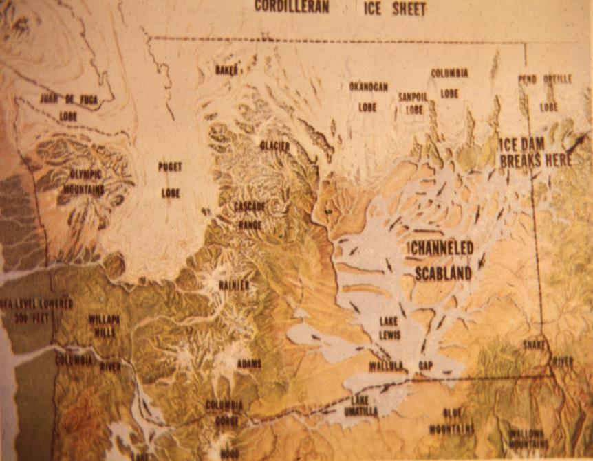
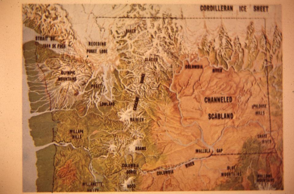
8 ~ 20,000 yrs ago Lake Columbia Lake Missoula 8
9 9
10 10

11 Erratic ice age floods, Sentinel Gap 11
12 N 1
13 13

14 Glacial effects on deposits and PM 14
 Pedogenesis and Soil Taxonomy Part II: The soil")
15 Organic Parent Material From Wilding et al. (1983) Pedogenesis and Soil Taxonomy Part II: The soil orders. 15

16 Johannessen and MacLennan


17 Sand Vashon Recessional Outwash Vashon Till Hardpan Loose Colluvial Material The Contact Streambed Typical Seattle geologic cross-section Lawton Clay Alluvial, Depression filling Soil Pre-Vashon Deposits Groundwater seepage 17 17


18 Washington Soil Series 18
 Soil Surveys Maps Profile descriptions")
19 Many counties in the U.S. have a Soil Survey produced by Natural Resources Conservation Service (NRCS) Soil Surveys Maps Profile descriptions Tables on soil properties: physical, chemical, engineering, land capabilities, plant growth 19
20 Alderwood Soil Series Association 20


21 KITSAP INDIANOLA ALDERWOOD 21
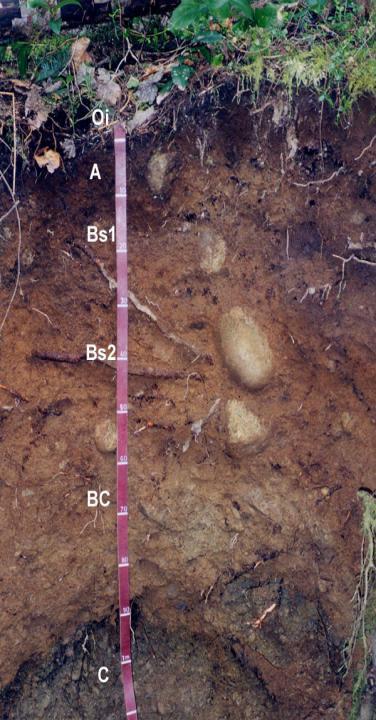
22 Lodgement till Ablation till ESC311/507 Important Soil Series in Seattle Area ALDERWOOD SERIES The Alderwood series con sists of moderately deep, moderately well drained soils formed in glacial till. Alderwood soils are on glacially modified foothills and valleys and have slopes of 0 to 65 percent. The average annual precipitation is about 40 inches, and the mean annual temperature is about 50 degrees F. TAXONOMIC CLASS: Loamy-skeletal, mixed, mesic Vitrandic Duroch repts TYPICAL PEDON: Alderwood grav elly loam - forested. (Colors are for moist soil unless otherwise no ted.) Ap--0 to 7 inches; very dark gray ish brown (10YR 3/2) gravelly sandy loam, brown (10YR 5/3) dry; moderate fine granular structure; slightly hard, very friable, slightly sticky and slightly plastic; many fine roots; few fine interstitial pores; slightly acid (ph 6.2); abrupt smooth bounda ry. (3 to 7 inches thick) Bs1--7 to 21 inches; dark yellowish brown (10YR 4/4) very gravelly sandy loam, yellowish brown (10YR 5/4) dry; weak medium subangu lar blocky structure; slightly hard, very friable, nonsticky and nonp lastic; many fine roots; many fine tubular and interstitial pores; 35 percent pebbles; diffuse smooth bounda ry; slightly acid (ph 6.2). Bs2--21 to 30 inches; dark brown (10YR 4/3) very gravelly sandy loam, pale brown (10YR 6/3); dry; weak medium subangul ar blocky structure; slightly hard, very friable, nonsticky and nonplastic; common fine roots; few very fine tubular pores; 40 percent pebbles; slightly acid (ph 6.2); clear wavy boundary. (Bs horizon 15 to 30 inches thick) 22
23 INDIANOLA SERIES The Indianola series consists of deep, somewhat exce ssively drained soils formed in sandy glacial drift and minor amounts of volcanic ash. Indianola soils are on terraces, terrace escarpments, eskers, and kames at elevations of near sea level to 1,000 feet. Slopes are 0 to 90 percent. The mean annual precipitation range s from 30 to 55 inches and the mean annual temperature is about 50 degrees F. TAXONOMIC CLASS: Mixed, mesic Dystric Xeropsamments TYPICAL PEDON: Indianola loamy sand-forested. (Colors are for moist soil unless otherwise stated.) A--0 to 6 inches;dark reddish-brown (5YR 3/3) loamy sand, brown (10YR 5/3) dry; weak coarse and medium subangu lar blocky structure; soft, very friable, nonsticky and nonplastic; many very fine and few coarse and medium roots; common fine tubular pores; neutral (ph 6.8); abrupt smooth boundary. (1 to 9 inches thick) Bw--6 to 13 inches; dark reddish-brown (5YR 3/4) loamy sand, pale brown (10YR 6/3) dry; weak coarse and medium subangu lar blocky structure; soft, very friable, nonsticky and nonplastic; common very fine and few medium roots; few fine tubular pores; neutral (ph 6.8); clear smooth bounda ry. (3 to 10 inches thick) BC--13 to 25 inches; dark brown (10YR 4/3) loamy sand, pale brown (10YR 6/3) dry; massive; soft, very friable, nonsticky and nonplastic; few very fine and fine roots; few very fine tubular pores; 5 percent rounded pebbles; neutral (ph 6.6); clear smooth boundary. (3 to 12 inches thick) C1--25 to 35 inches; dark yellowish-brown (10YR 4/4) sand, light brownish gray (2.5Y 6/2) single grain; loose; few very fine roots; few very fine tubular pores; 5 percent rounded p ebbles; neutral (ph 6.8); gradu al wavy boundary. (4 to 24 inches thick) 23
24 KITSAP SERIES The Kitsap series consists of deep, moderately well drained soils formed in lacustrine sediments. Kitsap soils are on terraces and terrace escarpments and have slopes of 0 to 70 percent. The mean annual precipitation is about 37 inches. The mean annual temperature is about 50 degrees F. TAXONOMIC CLASS: Fine-silty, mixed, mesic Aquandic Xerochrepts TYPICAL PEDON: Kitsap silt loam - pasture. (Colors are for moist soil unless otherwise noted.) Ap--0 to 6 inches; very dark gray ish brown (l0yr 3/2) silt loam, grayish brown (l0yr 5/2) dry; moderate fine subangu lar blocky structure; slightly hard, friable, slightly sticky and slightly plastic; many very fine roots; medium acid (ph 5.8); abrupt smooth boundary. (3 to 6 inches thick) B2l--6 to l0 inches; dark brown (l0yr 4/3) silt loam, pale brown (l0yr 6/3) dry; moderate fine subangu lar blocky structure; slightly hard, friable, slightly sticky and slightly plastic; many very fine roots; few very fine pores; many 2 to 5 mm light brown (7.5YR 6/4) concretions; medium acid (ph 6.0); clear wavy boundary. (3 to l2 inches thick) B22--l0 to l7 inches; brown (l0yr 4/3) silty clay loam, pale brown (l0yr 6/3) dry; moderate medium subangul ar blocky structure; hard, firm, sticky and p lastic; many very fine roots; common very fine pores about 3 percent fine pebbles; few 2 to 5 mm light brown (7.5YR 6/4) concretions; few silt balls; few krotovinas; slightly acid (ph 6.4); clear wavy boundary. (4 to 22 inches thick) 24
25 BELLINGHAM SERIES The Bellingh am series consists of deep, poorly drained soils formed in loess, alluvium, and lacustrine sediments. These soils are in depressions. Slopes of 0 to 3 percent. The average annual precipitation is about 48 inches and the mean annual temperature is about 50 degr ees F. TAXONOMIC CLASS: Fine, mixed, nonacid, mesic Typic Epiaquep ts TYPICAL PEDON: Bellingh am silty clay loam - pasture. (Colors are for moist soil unless otherwise noted. All textures are apparent field textures.) Ap--0 to 5 inches; black (10YR 2/1) silty clay loam, dark gray (10YR 4/1) dry; strong fine granular structure; hard, friable, sticky and plastic; many fine roots; moderately acid (ph 5.8): abrupt smooth boundary. (4 to 9 inches thick) Bg1--5 to 8 inches; gray (5Y 5/1) silty clay, light gray (N 7/) dry; few fine distinct yellowish brown (10YR 5/8) mottles; weak medium prismatic structure; very hard, firm, sticky and plastic; many fine roots; many medium tubular and ves icular pores; moderately acid (ph 6.0); clear smooth boundary. (2 to 13 inches thick) Bg2--8 to 14 inches; dark gray (5Y 4/1) silty clay, light gray (N 7/) dry; few fine distinct yellowish brown (10YR 5/8) mottles; moderate medium prismatic structure; very hard, firm, very sticky and very plastic; common fine roots; many medium tubular and interstitial pores; thin patchy pressure faces on peds and lining pores; slightly acid (ph 6.2); clear smooth boundary. (4 to 18 inches thick) 25
26 SEATTLE SERIES The Seattle series con sists of deep, very poorly drained o rgan ic soils formed in herbaceou s and woody deposits in depressions in river valleys and glacial till plains. Slopes are 0 to 1 percent. Average annual precipitation is about 40 inches. Mean annua l temperature is about 50 degrees F. TAXONOMIC CLASS: Euic, mesic Hemic Medisaprists TYPICAL PEDON: Seattle muck, pasture. (Colors are for moist soil unless otherwise noted.) Oap--0 to 11 inches; black (5YR 2/1) sapric material, black (10YR 2/1) dry; about 10 percent fibers, less than 1 percent rubbed; strong fine granu lar structure; hard, very friable, nonsticky, nonplastic; many roots; strongly acid (ph 5.4); clear smooth bounda ry. (10 to 13 inches thick) Oe1--11 to 17 inches; dark reddish brown (5YR 2/2) hemic material, black (10YR 2/1) and dark brown (10YR 4/3) dry; about 60 percent fibers, 25 percent rubbed; laminar structure; very hard, very friable, nonsticky, nonplastic; common roots; strongly acid (ph 5.1); clear smooth boundary. (3 to 12 inches thick) Oa2--17 to 21 inches; black (5YR 2/1) sapric material, black (5YR 2/1) dry; about 5 percent fibers, less than 1 percent rubbed; massive; very hard, very friable, slightly sticky, slightly plastic; few roots; very strongly acid (ph 4.8); clear wavy boundary. (0 to 6 inches thick) 26

27 Johannessen and MacLennan


28 Humans can affect our soils & environment SOILS = f (cl, r, o, p, t,..h) But so can the animals Woodway in Seattle
29 ESRM 311/SEFS 507 Field Trip Week #3, for use with accompanying map and soil descriptions Week 3 Field Trip - Arboretum trip Stop 1. Surprise soil. Stop 2. Urban fill. Mapped as as Inceptisol. Andept. This area is a combination of fill from the Lake Washington ship canal and other landfilling. Notice mottled appearance but lack of high water table in the winter. notice lack of OM Stop 3. Marsh Island, old trail. Mapped as Seattle series. Stop 4. Marsh Island, tall trees. Mapped as Seattle series. Note how most trees are small and spread out this site is an exception. Why? Stop 5. Marsh Island view from floating docks. Island mapped as Seattle series. Glacial action has created the many freshwater bodies in the State of Washington. Sedimentation has filled many in. Marsh Island is apparently the result of organic deposition in an environment where decomposition is slow. In addition, filling nearby areas might have pushed up organic material, forming islands. Note water table. Note appearance of OM. 29
30 Stop 6. Foster Island. Mapped as Bellingham (upper) and Seattle (lower areas) series. Clay soil; large trees. Note mottling within the soil profile. What caused this? Would this be a good garden soil? Between Stops 6 & 7. Recent construction on bank to prevent duck erosion. Large boulder on other side of the trail (glacial erratic). Stop at Arboretum building (only if necessary). Stop 7. French Drain Azalea Way. Mapped as series. The Arboretum wishes to keep Azalea Way grassed, but not muddy. Unfortunately, the soil situation here encourages subsoil water flow along restrictive layers on the slopes and surfacing on Azalea Way and below. 30
31 sandy drift compacted layer water flow till cut original slope Azalea Way fill silty sediments A French drain (a drain that is buried) has been cut along the uphill side of Azalea Way to help alleviate this. Water theoretically passes into the drain and under Azalea Way. Is this working? sandy drift compacted layer water flow till silty sediments cut original slope Azalea Way fill drainage under Azalea Way gravel filled french drain Stop 8. Modified French drain. Located at the bottom of the slope as a trench with rock exposed to help drain away (especially) surface water. Mapped as Bellingham series. Note that marks on a map that look like this...( ) could represent what? Some maps may have different symbols to represent the same parameter. What would this mean to the desired uses of the Arboretum? What steps would need to be taken to increase the suitability of this soil for use by the Arboretum. 31
Parent Materials. & some of Seattle s soils
 Parent Material & some of Seattle s soils ESRM 311/SEFS 507 Week 3 SOILS = f(cl, r, o, p, t) Parent Materials 1) Sedentary a) residual (bedrock weathered in place) b) organic 2) Transported by a) gravity
Soil Surveys. What are the most important properties to consider in a taxonomic system used for making a soil survey?
 Soil Surveys What are the most important properties to consider in a taxonomic system used for making a soil survey? What is a Soil Survey? Inventory of soil resources Delineation of spatial distribution
On-Site Soils Investigation. Buttermilk Way Storm water Treatment Project Buzzards Bay. MA. February 28 th, 2012
 1 On-Site Soils Investigation Buttermilk Way Storm water Treatment Project Buzzards Bay. MA February 28 th, 2012 Glenn Stanisewski, Resource Soil Scientist, USDA-NRCS, West Wareham, MA Introduction: The
Monitoring and modelling hydrological fluxes in support of nutrient cycling studies in Amazonian rain forest ecosystems Tobon-Marin, C.
 UvA-DARE (Digital Academic Repository) Monitoring and modelling hydrological fluxes in support of nutrient cycling studies in Amazonian rain forest ecosystems Tobon-Marin, C. Link to publication Citation
Jim Turenne. Soils on Social Media
 Jim Turenne USDA-NRCS 60 Quaker Lane, Suite 46 Warwick, RI. 02886 401-822-8832 Jim.turenne@ri.usda.gov Soils on Social Media www.twitter.com/soilsne www.fb.com/soilsne www.nesoil.com U.S. Department of
Soil Formation. Lesson Plan: NRES B2-4
 Soil Formation Lesson Plan: NRES B2-4 1 Anticipated Problems 1. What are five different factors that affect soil formation? 2. What are some different types of parent material that affect soils? 3. What
Figure DR3. Constraints on the depth of the hiatus surface based on 10 Be concentration of middle core sample.
 GSA Data Repository Item 2018099 Del Vecchio, J., DiBiase, R.A., Denn, A.R., Bierman, P.R., Caffee, M.W., and Zimmerman, S.R., 2018, Record of coupled hillslope and channel response to Pleistocene erosion
Introduction to Soil Science and Wetlands Kids at Wilderness Camp
 Introduction to Soil Science and Wetlands Kids at Wilderness Camp Presented by: Mr. Brian Oram, PG, PASEO B.F. Environmental Consultants http://www.bfenvironmental.com and Keystone Clean Water Team http://www.pacleanwater.org
Geology and New England Landscapes
 Geology and New England Landscapes Jim Turenne, CPSS USDA-NRCS Warwick, RI. http://nesoil.com Why Geology? Provides the big picture of site conditions. Major part of soil formation (parent material and
MINERALOGICAL ALTERATIONS OF SOIL IRRIGATED WITH ACIDIC MINE WATER IN THE ALAMOSA RIVER BASIN
 MINERALOGICAL ALTERATIONS OF SOIL IRRIGATED WITH ACIDIC MINE WATER IN THE ALAMOSA RIVER BASIN by Stephanie J. Connolly Steve W. Blecker Grant E. Cardon Eugene Kelly Colorado State University, Department
Maggie Payne Jim Turenne
 Maggie Payne Jim Turenne USDA-NRCS 60 Quaker Lane, Suite 46 Warwick, RI. 02886 401-822-8832 maggie.payne@ri.usda.gov U.S. Department of Agriculture 1935: Soil Conservation Service (SCS) Natural Resources
MAFF Ministry of IfiriLE Agriculture Fisheries and Food
 MAFF Ministry of IfiriLE Agriculture Fisheries and Food STATEMENT OF PHYSICAL CHARACTERISTICS AND AGRICULTURAL LAND CLASSIFICATION UPSLAND, KIRKLINGTON NORTH YORKSHIRE EXTRACTION OF SAND AND GRAVEL MARCH
Unit E: Basic Principles of Soil Science. Lesson 2: Understanding Soil Formation
 Unit E: Basic Principles of Soil Science Lesson 2: Understanding Soil Formation Important Terms Alluvium Bedrock Chemical weathering Climate Glacial till Loess Native vegetation Organic matter Outwash
Objectives. Introduction to Soils. Terms to know: What is soil? Study of Soils. The Soil Body 11/9/2012
 Objectives Explain what soil is and where it comes from Define a soil body List examples of the five soil-forming factors Explain how soils develop Introduction to Soils Terms to know: What is soil? Alluvial
Soils of the GLBRC Marginal Land Experiment (MLE) Sites
 Sites") KBS LTER Special Publication Soils of the GLBR Marginal Land Experiment (MLE) Sites. S. Kasmerchak and R. Schaetzl Department of Geography, Environmental, and Spatial Sciences Michigan State University
KBS LTER Special Publication Soils of the GLBR Marginal Land Experiment (MLE) Sites. S. Kasmerchak and R. Schaetzl Department of Geography, Environmental, and Spatial Sciences Michigan State University
Lowest and Youngest Terrace : Soil Pit #4
 Lowest and Youngest Terrace : Soil Pit #4 Observations : Where : Huntington Terraces Climate : Cloudy, mid 60 s Our soil pit was the lowest of the 4 sites The pit site was located on the right side of
SOIL PROFILE STUDY GUIDE
 2017 USDA, Natural Resources Conservation Service Yuri Plowden Ecological Site Specialist SOIL PROFILE STUDY GUIDE The purpose of this study guide is to help familiarize you with different characteristics
Soil Map Polk County, Florida
 Soil Map Polk County, Florida 28 9' 21'' 28 8' 23'' 3113000 3113200 3113400 3113600 3113800 3114000 3114200 3114400 3114600 81 51' 19'' 81 51' 19'' 416000 416000 ± 416200 416200 68 416400 68 416400 7 13
Standards and Procedures for Site Specific Soil Mapping in Rhode Island. Pg 1
 Standards and Procedures for Site Specific Soil Mapping in Rhode Island Pg 1 The Task Take This and Create This The Task Take This and Create This and a Report Pg 2 How is this different than the RI Soil
 UNIT DESCRIPTIONS: Artificial Fill, Undocumented (Afu): Locally derived sandy silt and silty sand, locally with clay and varying amounts of gravel and man-made debris. Abundant concrete rubble, in places
Colluvial debris: Rocks that have fallen down hills. Types of Parent Material
 Weathered Rocks from the lithosphere are the parent materials for soils Nature of the parent material will greatly influence time it takes to make soil and the nature of the soil that is formed Types of
Topic 6: Weathering, Erosion and Erosional-Deposition Systems (workbook p ) Workbook Chapter 4, 5 WEATHERING
 Workbook Chapter 4, 5 WEATHERING") Topic 6: Weathering, Erosion and Erosional-Deposition Systems (workbook p. 95-125) Workbook Chapter 4, 5 THE BIG PICTURE: Weathering, erosion and deposition are processes that cause changes to rock material
Topic 6: Weathering, Erosion and Erosional-Deposition Systems (workbook p. 95-125) Workbook Chapter 4, 5 THE BIG PICTURE: Weathering, erosion and deposition are processes that cause changes to rock material
BURIED SOILS OF GLOBE HILL, UPPER OHIO VALLEY
 BURIED SOILS OF GLOBE HILL, UPPER OHIO VALLEY HEBER D. LESSIG Soil Scientist, Box 248, Lisbon, Ohio A terrace, 5 mi downstream from Wellsville, Ohio, standing about 200 ft above the Ohio River, was recently
SOILS OF THE HIGH TERRACE REMNANTS IN THE UPPER OHIO VALLEY
 SOILS OF THE HIGH TERRACE REMNANTS IN THE UPPER OHIO VALLEY HEBER D. LESSIG Soil Conservation Service, U. S. Department of Agriculture, Box 248, Lisbon, Ohio INTRODUCTION Soils on the high terrace remnants
Soil Formation. Parent Material. Time. Climate
 Soil Formation Parent Material Time Climate Topography Biota Main Objectives 1. Gain a general understanding of soil formation processes 2. Understand the importance of mineral weathering in soil formation
Soils of Rhode Island
 Soils of Rhode Island Jim Turenne, RI State Soil Scientist USDA-NRCS 60 Quaker Ln. Suite 46 Warwick, RI. 02886 401-822-8830 http://nesoil.com Jim.turenne@ri.usda.gov About NRCS Established as the Soil
Chapter 5: Glaciers and Deserts
 I. Glaciers and Glaciation Chapter 5: Glaciers and Deserts A. A thick mass of ice that forms over land from the compaction and recrystallization of snow and shows evidence of past or present flow B. Types
Weathering, Erosion and Deposition
 Weathering, Erosion and Deposition Shaping the Earth s Surface Weathering the process of breaking down rocks into smaller fragments Erosion the transport of rock fragments from one location to another
HEBER D. LESSIG U.S. Soil Conservation Service, Box 248, Lisbon, Ohio
 THE SOILS DEVELOPED ON WISCONSIN AND ILLINOIAN- AGE GLACIAL OUTWASH TERRACES ALONG LITTLE BEAVER CREEK AND THE ADJOINING UPPER OHIO VALLEY, COLUMBIANA COUNTY, OHIO HEBER D. LESSIG U.S. Soil Conservation
FINAL REPORT Rangeland Rehabilitation through Water Conservation/Concentration
 FINAL REPORT Rangeland Rehabilitation through Water Conservation/Concentration Alyson McDonald, Extension Assistant - Hydrology and Charles Hart, Extension Range Specialist Photo Courtesy: Bill Thompson
Custom Soil Resource Report for Forrest County, Mississippi
 United States Department of Agriculture Natural Resources Conservation Service A product of the National Cooperative Soil Survey, a joint effort of the United States Department of Agriculture and other
Soil Map Boulder County Area, Colorado (Planet Blue Grass) Web Soil Survey National Cooperative Soil Survey
 Web Soil Survey National Cooperative Soil Survey") 475910 476000 476090 476180 476270 476360 105 16' 21'' W 476450 476540 476630 476720 476810 4453350 4453440 4453260 4453350 4453170 4453260 4453080 4453170 4453080 475820 475910 4452990 476000 476090 476180
475910 476000 476090 476180 476270 476360 105 16' 21'' W 476450 476540 476630 476720 476810 4453350 4453440 4453260 4453350 4453170 4453260 4453080 4453170 4453080 475820 475910 4452990 476000 476090 476180
Master Horizons. O horizon A horizon E horizon B horizon C horizon R horizon W horizon O A E
 Soil Horizons Master Horizons O horizon A horizon E horizon B horizon C horizon R horizon W horizon O A E B C R W Master Horizons O horizon predominantly organic matter (litter and humus) A horizon zone
Appendix F4.11 Geologic Unit Summaries, Hazard Areas, and Boring Locations
 Appendix F4.11 Geologic Unit Summaries, Hazard Areas, and Boring Locations Appendix F4.11 Geologic Unit Summaries and Hazard Areas TABLE F4.11-1 Summary of Geologic Units and their Engineering Properties
Science EOG Review: Landforms
 Mathematician Science EOG Review: Landforms Vocabulary Definition Term canyon deep, large, V- shaped valley formed by a river over millions of years of erosion; sometimes called gorges (example: Linville
Soil Mechanics. Chapter # 1. Prepared By Mr. Ashok Kumar Lecturer in Civil Engineering Gpes Meham Rohtak INTRODUCTION TO SOIL MECHANICS AND ITS TYPES
 Soil Mechanics Chapter # 1 INTRODUCTION TO SOIL MECHANICS AND ITS TYPES Prepared By Mr. Ashok Kumar Lecturer in Civil Engineering Gpes Meham Rohtak Chapter Outlines Introduction to Soil Mechanics, Soil
LANDFORM ANALYSIS AND SOIL RESOURCE INVENTORY USING REMOTE SENSING TECHNIQUE IN A WATERSHED OF UTTARANCHAL, INDIA
 LANDFORM ANALYSIS AND SOIL RESOURCE INVENTORY USING REMOTE SENSING TECHNIQUE IN A WATERSHED OF UTTARANCHAL, INDIA S.K.Mahapatra *, D. Martin, R.D.Sharma, S.P. Singh and J.P.Sharma National Bureau of Soil
Section I: Multiple Choice Select the best answer to each question. Mark your final answer on the answer sheet. (1 pt each)
") Sedimentary Rocks & Surface Processes Quest Name: Earth Science 2013 Block: Date: Section I: Multiple Choice Select the best answer to each question. Mark your final answer on the answer sheet. (1 pt each)
Sedimentary Rocks & Surface Processes Quest Name: Earth Science 2013 Block: Date: Section I: Multiple Choice Select the best answer to each question. Mark your final answer on the answer sheet. (1 pt each)
6W9}* Appendix 2 to report No. P62 SOIL RESOURCES MAP OF TH E MPEKETONIAREA (LAMU AND TANA RIVER DISTRICTS) 40" 40 E LEGEND ISWC U8RAWY _& Jl W*g*n)ng
 40 40 E LEGEND ISWC U8RAWY _& Jl W*g*n)ng") 6W9}* Appendix 2 to report No. P62 SOIL RESOURCES MAP OF TH E MPEKETONIAREA (LAMU AND TANA RIVER DISTRICTS) 40" 40 E LEGEND ISWC U8RAWY _& Jl W*g*n)ng«ft, Tlw 9MtWt&nât COASTAL PLAINS (slopes less than
6W9}* Appendix 2 to report No. P62 SOIL RESOURCES MAP OF TH E MPEKETONIAREA (LAMU AND TANA RIVER DISTRICTS) 40" 40 E LEGEND ISWC U8RAWY _& Jl W*g*n)ng«ft, Tlw 9MtWt&nât COASTAL PLAINS (slopes less than
Erosion and Deposition in a Juniper Woodland: The Chicken or the Egg?
 This file was created by scanning the printed publication. Errors identified by the software have been corrected; however, some errors may remain. Erosion and Deposition in a Juniper Woodland: The Chicken
Lecture 2: Soil Properties and Groundwater Flow
 ENGI 7718 Environmental Geotechniques ENGI 9621 Soil Remediation Engineering Lecture 2: Soil Properties and Groundwater Flow Spring 2011 Faculty of Engineering & Applied Science 1 2.1 Soil properties 2.1.1
Subsurface Erosion in Response to Land Management Changes and Soil Hydropedology. G.V. Wilson, J. R. Rigby, S.M. Dabney
 Subsurface Erosion in Response to Land Management Changes and Soil Hydropedology G.V. Wilson, J. R. Rigby, S.M. Dabney USDA-ARS National Sedimentation Laboratory Soil Pipeflow & Internal Erosion Impacts
Depth (ft) USCS Soil Description TOPSOIL & FOREST DUFF
 USCS Soil Description TOPSOIL & FOREST DUFF") Test Pit No. TP-6 Location: Latitude 47.543003, Longitude -121.980441 Approximate Ground Surface Elevation: 1,132 feet Depth (ft) USCS Soil Description 0 1.5 1.5 5.0 SM 5.0 8.0 SM Loose to medium dense,
Test Pit No. TP-6 Location: Latitude 47.543003, Longitude -121.980441 Approximate Ground Surface Elevation: 1,132 feet Depth (ft) USCS Soil Description 0 1.5 1.5 5.0 SM 5.0 8.0 SM Loose to medium dense,
Fossils and Geology of Litzsinger Road Ecology Center
 Fossils and Geology of Litzsinger Road Ecology Center Table of Content Key Terms 1 Key Terms 2 What you need to know Geologic Map of Missouri Geologic Time Chart More of what you need to know Digital map
Class Notes: Surface Processes
 Name: Date: Period: Surface Processes The Physical Setting: Earth Science Class Notes: Surface Processes I. Weathering and Soils Weathering -! Sediments -! Weathering occurs when rocks are exposed to:
Curtis Monger USDA-NRCS Developments in Soil Taxonomy
 Curtis Monger USDA-NRCS Developments in Soil Taxonomy rice ANTHROPOCENE? Ca Curtis Monger USDA-NRCS Developments in Soil Taxonomy rice ANTHROPOCENE? Soil sustainability differs across the landscape. Ca
For Sale at $437,500.00
 We are pleased to present Carlson Farm 72.43 ± Acres Garden City Township, Blue Earth County For Sale at $437,500.00 Listing Agent: Darrell Hylen, ALC Office: 507-345-LAND (5263) Toll Free: 800-730-LAND
Lab 7: Sedimentary Structures
 Name: Lab 7: Sedimentary Structures Sedimentary rocks account for a negligibly small fraction of Earth s mass, yet they are commonly encountered because the processes that form them are ubiquitous in the
Correlation of Tills Exposed in Toledo Edison Dam Cut, Ohio
 The Ohio State University Knowledge Bank kb.osu.edu Ohio Journal of Science (Ohio Academy of Science) Ohio Journal of Science: Volume 60, Issue 2 (March, 1960) 1960-03 Correlation of Tills Exposed in Toledo
Appendix I SOIL RATING CHART. (Storie soil Index Rating = factor A* factor B* factor C* factor X) FACTOR A- Rating on character of Physical Profile
 FACTOR A- Rating on character of Physical Profile") Appendix I SOIL RATING CHART (Storie soil Index Rating = factor A* factor B* factor C* factor X) FACTOR A- Rating on character of Physical Profile Sr. No Particulars Percentage I Soil on recent alluvial
Appendix I SOIL RATING CHART (Storie soil Index Rating = factor A* factor B* factor C* factor X) FACTOR A- Rating on character of Physical Profile Sr. No Particulars Percentage I Soil on recent alluvial
Supplementary Material: Crop & Pasture Science, 2013, 64(12),
,") 10.1071/CP13168_AC CSIRO 2013 Supplementary Material: Crop & Pasture Science, 2013, 64(12), 1182 1194. Hydrological and water-use efficiency implications of geomorphological stratification in palæochannels
10.1071/CP13168_AC CSIRO 2013 Supplementary Material: Crop & Pasture Science, 2013, 64(12), 1182 1194. Hydrological and water-use efficiency implications of geomorphological stratification in palæochannels
EARTH S CHANGING SURFACE
 EARTH S CHANGING SURFACE Weathering Together, weathering and erosion work continuously to wear down the material on Earth s surface. weathering process that breaks down rock and other substances of Earth
Figure 1 The map shows the top view of a meandering stream as it enters a lake. At which points along the stream are erosion and deposition dominant?
 1. In which type of climate does chemical weathering usually occur most rapidly? 1. hot and dry 3. cold and dry 2. hot and wet 4. cold and wet 2. Figure 1 The map shows the top view of a meandering stream
Rocks and Weathering
 Rocks and Weathering The Effects of Weathering The process of mountain building thrusts rock up to Earth s surface. Weathering is the process that breaks down rock and other substances at Earth s surface.
Feet. SAND; clayey, fine grained; shells are common; rounded quartz grains. SHELLS; muddy; almost no sand, shells and fragments common
 SAND; clayey, fine grained; shells are common; rounded quartz grains SHELLS; muddy; almost no sand, shells and fragments common SAND; back to medium to fine; has a mottled appearance and looks burrowed;
Quaternary Research Center. Soils and Land Use in the Puget Sound Basin
 Quaternary Research Center Home About People Research Journal Resource Center Events Facilities Soils and Land Use in the Puget Sound Basin Ronald S. Sletten, Dept. of Civil Engineering, University of
Circle the correct (best) terms inside the brackets:
 terms inside the brackets:") 1 Circle the correct (best) terms inside the brackets: 1) Soils are [consolidated / unconsolidated] [natural / artificial] bodies at the earth s surface. Soils contain mineral and organic material, which
1 Circle the correct (best) terms inside the brackets: 1) Soils are [consolidated / unconsolidated] [natural / artificial] bodies at the earth s surface. Soils contain mineral and organic material, which
3.3 CLIMATE, GEOLOGY, TOPOGRAPHY, AND SOILS CLIMATE GEOLOGY TOPOGRAPHY
 3.3 CLIMATE, GEOLOGY, TOPOGRAPHY, AND SOILS This section describes the climate, geology, topography, and soil resource characteristics of the Yolo Bypass Wildlife Area (Wildlife Area). Agricultural soil
APPENDIX P4.10 Background Information for Section 4.10, Geology and Soils
 Central Link Light Rail Transit Project Final Supplemental Environmental Impact Statement North Link APPENDIX P4.10 Background Information for Section 4.10, Geology and Soils Appendix P4.10 Background
Pre-Lab Reading Questions ES202
 ES202 The are designed to encourage students to read lab material prior to attending class during any given week. Reading the weekly lab prior to attending class will result in better grade performance
4. Soils and soil conditions
 4. Soils and soil conditions 4.1 General characteristics 4.1.1 Soil-forming processes Most soils of the Bardenas area show no distinct characteristics of soil development. Except in the ancient alluvium
Geo 302D: Age of Dinosaurs. LAB 2: Sedimentary rocks and processes
 Geo 302D: Age of Dinosaurs LAB 2: Sedimentary rocks and processes Last week we covered the basic types of rocks and the rock cycle. This lab concentrates on sedimentary rocks. Sedimentary rocks have special
Weathering, Erosion & Soils Quiz
 Weathering, Erosion & Soils Quiz Multiple Choice Identify the choice that best completes the statement or answers the question. 1. The diagram below shows a cross-section of a rock layer. Erosion is the
LAB 4 FIELD STUDY OF SOIL: DESCRIBING SOIL HORIZON WITH SOIL PROPERTIES
 LAB 4 FIELD STUDY OF SOIL: DESCRIBING SOIL HORIZON WITH SOIL PROPERTIES Learning outcomes The student is able to: 1. describe the soil properties of soil horizons 2. describe the full description of a
Clyde River Landslide
 Clyde River Landslide Department of Geology, Perkins Hall, University of Vermont, Burlington, VT 05405 Abstract: This paper investigates a landslide on the Clyde River in Newport, Vermont. The landslide
Custom Soil Resource Report Soil Map
 121 3' 56'' W Custom Soil Resource Report Soil Map 121 2' 49'' W 45 16' 39'' N 5013800 5014000 5014200 5014400 5014600 5014800 5015000 5015200 5015400 5015600 651800 652000 652200 652400 652600 652800
Lecture Outline Wednesday - Friday February 14-16, 2018
 Lecture Outline Wednesday - Friday February 14-16, 2018 Quiz 2 scheduled for Friday Feb 23 (Interlude B, Chapters 6,7) Questions? Chapter 6 Pages of the Past: Sedimentary Rocks Key Points for today Be
Custom Soil Resource Report Soil Map
 77 35' 22'' W Custom Soil Resource Report Soil Map 77 35' 0'' W 282170 282220 282270 282320 282370 282420 282470 282520 282570 282620 40 59' 2'' N 40 58' 52'' N 4539900 4539950 4540000 4540050 4540100
The Marine Environment
 The Marine Environment SECTION 16.1 Shoreline Features In your textbook, read about erosional landforms, beaches, estuaries, longshore currents, and rip currents. For each statement below, write or. 1.
Depth to the Apparent Water Table in 17 New York Soils from 1963 to 1970*
 NEW YORK'S FOOD AND LIFE SCIENCES BULLETIN NO. 13, MARCH 1972 CORNELL UNIVERSITY AGRICULTURAL EXPERIMENT STATION, NEW YORK STATE COLLEGE OF AGRICULTURE AND LIFE SCIENCES, A STATUTORY COLLEGE OF THE STATE
Biosphere. All living things, plants, animals, (even you!) are part of the zone of the earth called the biosphere.
 are part of the zone of the earth called the biosphere.") Unit 1 Study Guide Earth s Spheres Biosphere All living things, plants, animals, (even you!) are part of the zone of the earth called the biosphere. Hydrosphere Water covers ¾ of the earth, made up mostly
Unit 1 Study Guide Earth s Spheres Biosphere All living things, plants, animals, (even you!) are part of the zone of the earth called the biosphere. Hydrosphere Water covers ¾ of the earth, made up mostly
Prentice Hall EARTH SCIENCE
 Prentice Hall EARTH SCIENCE Tarbuck Lutgens Chapter 7 Glaciers, Desert, and Wind 7.1 Glaciers Types of Glaciers A glacier is a thick ice mass that forms above the snowline over hundreds or thousands of
,Baynes Lake. TO...?&.?...A 2...KO.?'!!&... Sr. *logical Engineer
 > i evernment OF BRITISH COLUMBIA a TO...?&.?...A 2....KO.?'!!&... Sr. *logical Engineer... Grou,,water. Section Hydrology Division Wat.er... In~.~s.tiga.ti.On.s..Branck.... 5 u BJECT...C;.roun.dw.ater...Snve
Unit 4: Landscapes Practice Problems
 Name: Date: 1. Soil with the greatest porosity has particles that are A. poorly sorted and densely packed B. poorly sorted and loosely packed C. well sorted and densely packed D. well sorted and loosely
 SOIL CLASSIFICATION CHART COARSE-GRAINED SOILS MORE THAN 50% RETAINED ON NO.200 SIEVE FINE-GRAINED SOILS 50% OR MORE PASSES THE NO.200 SIEVE PRIMARY DIVISIONS GRAVELS MORE THAN 50% OF COARSE FRACTION RETAINED
NACTA 2013 Soils Judging-2 Year Division
 Department of Animal and Food Sciences NACTA 2013 Soils Judging-2 Year Division Date: April 5, 2013 Contact: Dr. Richard Zartman richard.zartman@ttu.edu Rules: 1.Each team will consist of four (4) members
Soil Profiles (West, Ch. 8)
") Geology 229 Engineering Geology Lecture 24 Soil Profiles (West, Ch. 8) We have just finished the discussion of rock weathering. One direct consequence of weathering is the formation of the soil profile.
Geology 229 Engineering Geology Lecture 24 Soil Profiles (West, Ch. 8) We have just finished the discussion of rock weathering. One direct consequence of weathering is the formation of the soil profile.
Earth Science S5E1b (EarthScienceS5E1b)
") Name: Date: 1. The flattest part of the ocean floor is the A. trench. B. abyssal plain. C. continental shelf. D. mid-ocean rift valley. 2. Which causes some parts of the ocean to be saltier than other
Name: Date: 1. The flattest part of the ocean floor is the A. trench. B. abyssal plain. C. continental shelf. D. mid-ocean rift valley. 2. Which causes some parts of the ocean to be saltier than other
STUDY GUIDE FOR CONTENT MASTERY. Surface Water Movement
 Surface Water SECTION 9.1 Surface Water Movement In your textbook, read about surface water and the way in which it moves sediment. Complete each statement. 1. An excessive amount of water flowing downslope
What are the different ways rocks can be weathered?
 Romano - 223 What are the different ways rocks can be weathered? Weathering - the breakdown of rocks and minerals at the Earth s surface 1. 2. PHYSICAL WEATHERING Rock is broken into smaller pieces with
Your web browser (Safari 7) is out of date. For more security, comfort and the best experience on this site: Update your browser Ignore
 is out of date. For more security, comfort and the best experience on this site: Update your browser Ignore") Your web browser (Safari 7) is out of date. For more security, comfort and the best experience on this site: Update your browser Ignore ALLU VIAL FAN colluvial fan, debris cone For the complete encyclopedic
Your web browser (Safari 7) is out of date. For more security, comfort and the best experience on this site: Update your browser Ignore ALLU VIAL FAN colluvial fan, debris cone For the complete encyclopedic
Circle the best answer for each question. There are a total of 50 questions.
 Winter Packet 2013 Name Period ircle the best answer for each question. There are a total of 50 questions. 1. What occurs when ions from the Sun hit air molecules and cause them to emit vivid colors of
Weathering is the process that breaks down rock and other substances at Earth s surface
 Chapter 8 Notes Weathering is the process that breaks down rock and other substances at Earth s surface Factors that contribute to weathering Heat Cold Water Ice O 2 & CO 2 in the atmosphere Examples of
Sediment. Weathering: mechanical and chemical decomposition and disintegration of rock and minerals at the surface
 Sediment Some basic terminology Weathering: mechanical and chemical decomposition and disintegration of rock and minerals at the surface Erosion: removal of weathered rock and minerals from one place to
Don Elsenheimer, Ph.D Glenn Melchert Minnesota Dept. Natural Resources
 Regional Survey of Gold in Till, Bigfork Greenstone Belt, St. Louis & Itasca Counties, Minnesota: Follow-up Trenching in Areas with Anomalously High Gold Grain Counts Don Elsenheimer, Ph.D Glenn Melchert
HYDRIC SOILS. Background
 Background HYDRIC SOILS Soils consist of natural bodies that occur on a landform within a landscape and have properties that result from the integrated effects of climate and living organisms, acting on
 TP-1 N61E 0 DARK BROWN SANDY SILT (ML) stiff, wet with roots (Disturbed Surficial Soil) DEPTH (FEET) 5 REDDISH BROWN SANDSTONE intensely fractured, weak to friable, deeply weathered, tight (Franciscan
Subsurface Geology of the Kennebec River
 Maine Geologic Facts and Localities July, 1998 Subsurface Geology of the Kennebec River 43 54 40.75 N, 69 48 29.01 W Text by Daniel B. Locke, Department of Agriculture, Conservation & Forestry 1 Map by
Weathering, Erosion, Deposition, and Landscape Development
 Weathering, Erosion, Deposition, and Landscape Development I. Weathering - the breakdown of rocks into smaller particles, also called sediments, by natural processes. Weathering is further divided into
Sediment and sedimentary rocks Sediment
 Sediment and sedimentary rocks Sediment From sediments to sedimentary rocks (transportation, deposition, preservation and lithification) Types of sedimentary rocks (clastic, chemical and organic) Sedimentary
1. Any process that causes rock to crack or break into pieces is called physical weathering. Initial product = final product
 Weathering 1. Any process that causes rock to crack or break into pieces is called physical weathering. Initial product = final product End Result of physical weathering is increased surface area. 2. Physical
Soils in Minnesota Calcareous Fens
 Soils in Minnesota Calcareous Fens MGWA TECHNICAL WORKSHOP June 18, 2004 George Poch 6/23/2004 1 Introduction Our presentation today is to show What soils are in the Fen areas How they have been mapped
Lecture 7: Introduction to Soil Formation and Classification
 Lecture 7: Introduction to Soil Formation and Classification Soil Texture and Color Analysis Lab Results Soil A: Topsoil from Prof. Catalano s backyard Soil B: Soil above beach at Castlewood State Park
Chapter 6 Sedimentary and Metamorphic Rock
 Chapter 6 Sedimentary and Metamorphic Rock Weathering and Erosion Wherever rock is exposed at Earth s surface, it is continuously being broken down by weathering a set of physical and chemical processes
4 Formation of glacial ice 3. 5 Formation of glacial ice (cont.) 3. 6 Glacier economy and general flow structure 4
 3. 6 Glacier economy and general flow structure 4") Contents 1 Glacier Flow 2 2 Definition 2 3 Amount 3 4 Formation of glacial ice 3 5 Formation of glacial ice (cont.) 3 6 Glacier economy and general flow structure 4 7 Example 5 8 Examples 6 9 Ice movement
Contents 1 Glacier Flow 2 2 Definition 2 3 Amount 3 4 Formation of glacial ice 3 5 Formation of glacial ice (cont.) 3 6 Glacier economy and general flow structure 4 7 Example 5 8 Examples 6 9 Ice movement
RALPH SIMMONS STATE FOREST 2016 LAND MANAGEMENT PLAN EXHIBITS
 RALPH SIMMONS STATE FOREST 2016 LAND MANAGEMENT PLAN EXHIBITS EXHIBIT A Location Map Exhibit A EXHIBIT B Management Accomplishment Summary for RSSF EXHIBIT C Proximity to Other Public Lands Exhibit C
MASS MOVEMENTS, WIND, AND GLACIERS
 Date Period Name MASS MOVEMENTS, WIND, AND GLACIERS SECTION.1 Mass Movements In your textbook, read about mass movements. Use each of the terms below just once to complete the passage. avalanche creep
 Page 1 of 9 Name: Base your answer to the question on the diagram below. The arrows show the direction in which sediment is being transported along the shoreline. A barrier beach has formed, creating a
SUPPLEMENTAL MATERIAL
 SUPPLEMENTAL MATERIAL DESCRIPTIONS OF OTHER STRATIGRAPHIC SECTIONS Cherry Creek In its middle reaches, Cherry Creek meanders between three paired terraces within a narrow bedrock valley. The highest is
LAA. Wassents that have sulfidic materials within 50 cm of the mineral soil surface. Sulfiwassents
 Wassents Wassents are subaqueous Entisols. Defined as Entisols that have a positive water potential at the soil surface for at least 90% of each day. These soils are the first suborder to classify out