Soils of Rhode Island
|
|
|
- Sabrina York
- 5 years ago
- Views:
Transcription


1 Soils of Rhode Island Jim Turenne, RI State Soil Scientist USDA-NRCS 60 Quaker Ln. Suite 46 Warwick, RI

2 About NRCS Established as the Soil Conservation Service to combat the soil erosion know as the dust bowl in 1935 Provide technical assistance to private land owners to address soil, water, air, plant/animal concerns. RI NRCS

3 Soil Science (Pedology) The scientific study of soils, including their origins, characteristics, and uses. Many different areas soil chemistry, physics, genesis, classification, morphology. A soil scientist can read the layers of earth to tell what has occurred in the past (ST). Narragansett Silt Loam The (Unofficial) State Soil of RI


4 Soil - Definition Natural body that occurs on the land surface, occupies space, and is characterized by one or both of the following: Horizons formed by pedogenesis. The ability to support rooted plants in a natural environment.


5 Why are Soils Important? Importance to Society Food, fiber, woodland, waste disposal, filter of pollutants, used by most animals to live in and on, part of nutrient and hydrologic cycle.
")

6 Soil Formation Biota Climate Topography SOIL! Parent Material (The first four factors over) Time These five factors work together to create a unique soil profile made of layers called horizons.
. Types of minerals. Reaction of soil. Soil Color.")

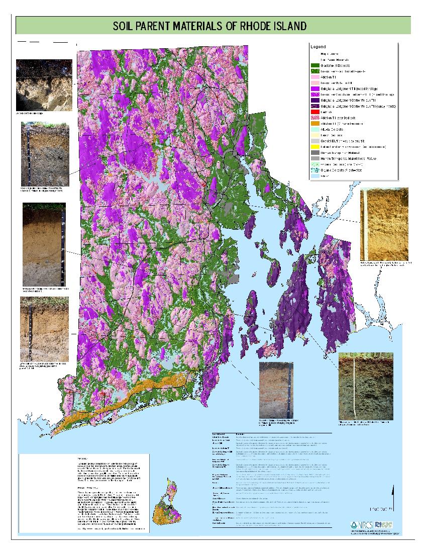
7 Soil Forming Factor: Parent Geologic material the soil formed from (or in). Types of minerals. Reaction of soil. Soil Color. Chemical/physical properties Types of PM: Bedrock, Glacial, Volcanic, Organic, Loess, Colluvium, Alluvium, Residuim, Karst, etc. Material
8
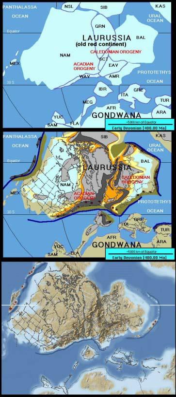
 - 1.8 MYBP to 8 KYBP. 4 Major advances.")

9 RI Parent Materials Pleistocene Epoch (Ice Age) MYBP to 8 KYBP. 4 Major advances. Last- Wisconsinan advance covered all of NE. Soil parent materials - glacial & post glacial


10 Unsorted/stratified material deposited beneath and within glacial ice. Heterogeneous mixture of all particle sizes (boulder to clay). Oldest surficial deposit overlying most bedrock areas. Glacial Till


11 Till Properties Major Types: Basal and Ablation. Landforms: Drumlins, moraines, Ice contact. Basal till has a dense restrictive layer which impedes downward water movement. Large angular stones and boulders.

12 Hydrology in Tills Hardpan (dense till) perches water causing wet basements, wetlands on hill tops and slopes drainage driven by landscape position.

.")
13 Glacial Fluvial (outwash) Sediments deposited by glacial meltwater. Stratified layers of sand, gravel, and fines. Types: Proglacial and Proximal (ice contact). Landforms: Plains, eskers, kames, deltas.

14 Outwash Properties Dominantly sand and gravel sized particles. Rapid water movement, associated with aquifers. Apparent watertable. Few limitations for most uses.
15 Outwash Hydrology Concerns Apparent watertables, generally easy to interpret hydrology. Large pore space causes rapid permeability. Aquifer recharge areas. Poor filtering capacity.

16 Post Glacial Deposits Material deposited after glacier left (Holocene-10K BP). Eolian - wind deposited sand to silt sized particles. Most upland soils in NE have a thin inch eolian cap. Deposited rapidly after ice left.

17 Post Glacial Deposits Alluvium - sediments deposited in modern-day floodplains. Organic - material consisting of decaying plant material. - source of fuel grade peat. Study of Chapman Swamp showed enough peat to power 20% of the homes in Westerly for 45 years.

18 Post Glacial Deposits Anthro-transported material (Cut and Fill) - recent sediments deposited or removed by human activity. - Lot of areas in the NE have been altered by humans. - Difficult morphology, often lacking horizons. Fill Organic
. Elevation. Aspect. Slope.")
19 Soil Forming Factor: Relief and Landscape Factors Position on the landscape (convex/concave). Elevation. Aspect. Slope. Water movement Most wetlands on concave landforms.


20 Reading Topographic Maps Contour lines shows areas of equal elevation. Also shows drainage, cultural features, water, etc. Convex slope Concave slope


 Hummocky to steep")

21 RI Landscapes Outwash Plains Level to undulating areas composed of stratified sand and gravel. End Moraines (outwash heads) Hummocky to steep areas with bouldery surfaces composed of loose sandy till and ice-contact outwash.
22 Soil Characteristics & Properties Landscape Features: 1. Position 2. Slope 3. Stoniness 4. Rockiness 5. Drainage 6. Parent Material Soil Profile Features: 1. Horizons 2. Color 3. Texture 4. Permeability 5. Structure

23 Soil Horizons A layer of soil, approximately parallel to the surface, having distinct characteristics produced by soil forming processes. Used to classify the soil and make interpretations.

24 Soil Color Easily identified property. Used to relate chemical/physical properties such as watertable depth, drainage, chemical constituents, formation, horizons.
25 Color Components Organic Matter (carbon): Very strong coloring agent. Makes soil dark or black colored such as in an A horizon or topsoil. Compounds and elements: Such as iron, sulfur, manganese, etc. Iron is a dominant element in soils, when well aerated iron-oxides coat particles giving the soil a yellowish-brown to reddish color.
26 Soil Properties: Texture Soil Texture: The relative proportions of sand, silt, and clay particles in a mass of soil (material less than 2mm in size). Very Coarse Sand Very Fine Sand Silt Clay mm mm mm < mm

27 Soil Texture (cont.) Material larger than 2 mm are coarse fragments (gravel, cobble, stone, boulder). Importance: Soil formation, mechanics, water movement, erosion, CEC, shrinkswell, etc. Clay: High specific surface, net negative charge (isomorphic), high pore, expansion. Most textures in NE have very little clay.

28 Soil Texture Triangle Triangle is used if laboratory data is available: Example: Sand = 60% Silt = 30% Clay = 10% Soil Texture = Sandy Loam


29 Soil Properties - related to texture Porosity: An index of the relative pore volume in the soil. Infiltration: The downward entry of water into the immediate surface of soil or other material. Erodibility: In general, large particles are less erodible, exceptions being clay. Available Water Holding Capacity: Silt loam textures have highest.


30 Soil Properties - related to texture Shrink-Swell: High activity clays have high factors. Soil Formation: Clayey soils = older. Permeability: The quality of the soil that enables water to move downward through the profile. Number of in/hr that water moves downward through saturated soil.


31 The frequency and duration of periods of saturation or partial saturation during soil formation. Depth to water. Classes: Excessively, well, moderately well, poorly, very poorly drained. Soil Drainage


32 Soil Surveys A soil survey describes the characteristics of the soils in a given area, classifies the soils according to a standard system of classification, plots the boundaries of the soils on a map, and makes predictions about the behavior of soils. Extensive field work!

33 Soil Interpretations Suitability of a soil for specific land uses such as agricultural, urban, forestry, environmental assessment, and development. Envirothon Interps: Farmland Houses Septic Systems

34 Hydric Soils Soil Survey Data


35 Soil Suitability for Development Alluvial Soil Deep sandy Soil Organic Soil Wet till Soil


36 Regulatory Issues Related to Soil Wetlands, ISDS Septic Systems, Erosion Protection, Stormwater Runoff, Zoning Issues.


37 Hydric Soils A hydric soil is a soil that formed under conditions of saturation, flooding, or ponding long enough during the growing season to develop anaerobic conditions in the upper part.


38 Septic System Function Treatment of Effluent to remove or reduce: 1. Suspended Solids. 2. Nitrates and Nutrients. 3. Bacteria and Pathogens. 4. Filter effluent before it is returned to ground water.

.")

39 14 million acres of prime farmland were developed between 1982 and 2007 (about the size of West Virginia). Est. 30,000 acres of Prime Farmland lost in RI Farmland Loss


40 Soil Erosion Concerns Types of Erosion: Sheet, Rill, Gully Highly Erodible Soils: soil texture and slope Erosion Control: Ag. - contour plowing, terracing, buffer strips, no till, cover crops in winter. Urban silt fences, hydro seed, limit stockpile size.

41 Stormwater Runoff Need to control the effects of creating impervious material during the conversion of land use (woodland to sub-urban). 1,000 square feet of impervious ground generates 28, 000 gallons of run-off each year! Soils are used to determine the size of detention ponds to store run-off (soil hydrologic groups) in drainage calculations.

42 Indicate intensive land uses that cause pollution Inhibit recharge of groundwater Prevent natural processing of pollutants in soil, plants Provide a surface for accumulation of pollutants Provide an express route for pollutants to waterways Impervious Surfaces


43 Development Impacts on Water Quality Increased quantity Decreased quality Nutrients Pathogens Sediment Toxic Contaminants Debris Thermal Stress

44 Development Impacts on the Water Cycle 10% 50% 55% 15%

45 How much runoff? Calculate Runoff: 0.02 square miles or 557,868 sq. ft. of impervious ground X 4 feet rain/yr =2,231,472 cu ft 1 cu ft = 7.4 gal = 15,640,868 gallons!
46

47 Questions
Jim Turenne. Soils on Social Media
 Jim Turenne USDA-NRCS 60 Quaker Lane, Suite 46 Warwick, RI. 02886 401-822-8832 Jim.turenne@ri.usda.gov Soils on Social Media www.twitter.com/soilsne www.fb.com/soilsne www.nesoil.com U.S. Department of
Maggie Payne Jim Turenne
 Maggie Payne Jim Turenne USDA-NRCS 60 Quaker Lane, Suite 46 Warwick, RI. 02886 401-822-8832 maggie.payne@ri.usda.gov U.S. Department of Agriculture 1935: Soil Conservation Service (SCS) Natural Resources
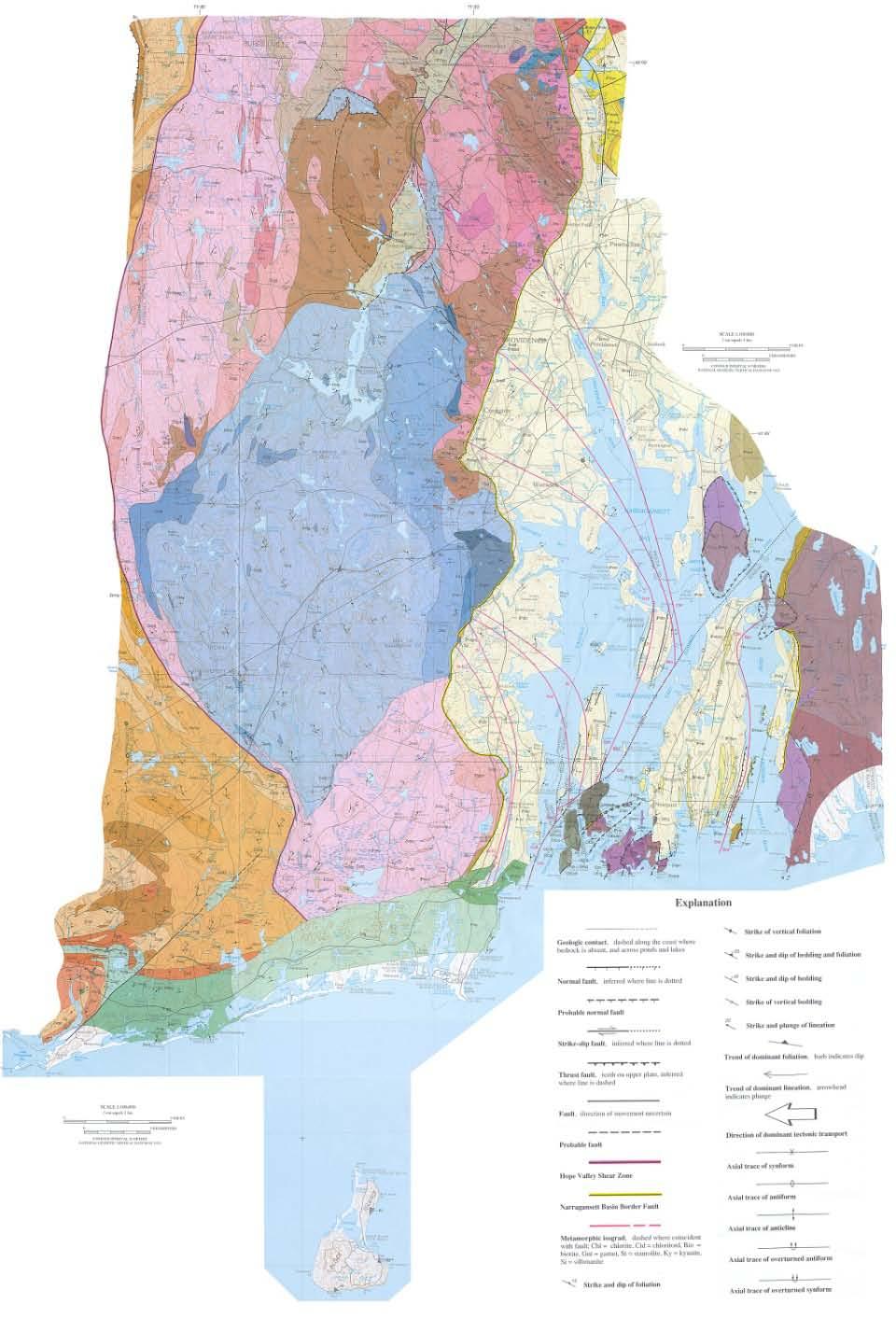
Geology and New England Landscapes
 Geology and New England Landscapes Jim Turenne, CPSS USDA-NRCS Warwick, RI. http://nesoil.com Why Geology? Provides the big picture of site conditions. Major part of soil formation (parent material and
Soils of Rhode Island What s Under It?
 Soils of Rhode Island What s Under It? Jim Turenne, CPSS Assistant State Soil Scientist USDA-NRCS60 Quaker Lane. Suite 46 Warwick, RI. http://nesoil.com www.ri.nrcs.usda.gov www.twitter.com/soil_sne Objective
Introduction to Soil Science and Wetlands Kids at Wilderness Camp
 Introduction to Soil Science and Wetlands Kids at Wilderness Camp Presented by: Mr. Brian Oram, PG, PASEO B.F. Environmental Consultants http://www.bfenvironmental.com and Keystone Clean Water Team http://www.pacleanwater.org
Soil Surveys. What are the most important properties to consider in a taxonomic system used for making a soil survey?
 Soil Surveys What are the most important properties to consider in a taxonomic system used for making a soil survey? What is a Soil Survey? Inventory of soil resources Delineation of spatial distribution
On-Site Soils Investigation. Buttermilk Way Storm water Treatment Project Buzzards Bay. MA. February 28 th, 2012
 1 On-Site Soils Investigation Buttermilk Way Storm water Treatment Project Buzzards Bay. MA February 28 th, 2012 Glenn Stanisewski, Resource Soil Scientist, USDA-NRCS, West Wareham, MA Introduction: The
Soil Formation. Lesson Plan: NRES B2-4
 Soil Formation Lesson Plan: NRES B2-4 1 Anticipated Problems 1. What are five different factors that affect soil formation? 2. What are some different types of parent material that affect soils? 3. What
EARTH S CHANGING SURFACE
 EARTH S CHANGING SURFACE Weathering Together, weathering and erosion work continuously to wear down the material on Earth s surface. weathering process that breaks down rock and other substances of Earth
Standards and Procedures for Site Specific Soil Mapping in Rhode Island. Pg 1
 Standards and Procedures for Site Specific Soil Mapping in Rhode Island Pg 1 The Task Take This and Create This The Task Take This and Create This and a Report Pg 2 How is this different than the RI Soil
Rocks and Weathering
 Rocks and Weathering The Effects of Weathering The process of mountain building thrusts rock up to Earth s surface. Weathering is the process that breaks down rock and other substances at Earth s surface.
Soil Map Boulder County Area, Colorado (Planet Blue Grass) Web Soil Survey National Cooperative Soil Survey
 Web Soil Survey National Cooperative Soil Survey") 475910 476000 476090 476180 476270 476360 105 16' 21'' W 476450 476540 476630 476720 476810 4453350 4453440 4453260 4453350 4453170 4453260 4453080 4453170 4453080 475820 475910 4452990 476000 476090 476180
475910 476000 476090 476180 476270 476360 105 16' 21'' W 476450 476540 476630 476720 476810 4453350 4453440 4453260 4453350 4453170 4453260 4453080 4453170 4453080 475820 475910 4452990 476000 476090 476180
Soil Formation. Parent Material. Time. Climate
 Soil Formation Parent Material Time Climate Topography Biota Main Objectives 1. Gain a general understanding of soil formation processes 2. Understand the importance of mineral weathering in soil formation
Section I: Multiple Choice Select the best answer to each question. Mark your final answer on the answer sheet. (1 pt each)
") Sedimentary Rocks & Surface Processes Quest Name: Earth Science 2013 Block: Date: Section I: Multiple Choice Select the best answer to each question. Mark your final answer on the answer sheet. (1 pt each)
Sedimentary Rocks & Surface Processes Quest Name: Earth Science 2013 Block: Date: Section I: Multiple Choice Select the best answer to each question. Mark your final answer on the answer sheet. (1 pt each)
Unit E: Basic Principles of Soil Science. Lesson 2: Understanding Soil Formation
 Unit E: Basic Principles of Soil Science Lesson 2: Understanding Soil Formation Important Terms Alluvium Bedrock Chemical weathering Climate Glacial till Loess Native vegetation Organic matter Outwash
Weathering is the process that breaks down rock and other substances at Earth s surface
 Chapter 8 Notes Weathering is the process that breaks down rock and other substances at Earth s surface Factors that contribute to weathering Heat Cold Water Ice O 2 & CO 2 in the atmosphere Examples of
Michigan s Geology and Groundwater
 Michigan s Geology and Groundwater Ralph J. Haefner Deputy Director U.S. Geological Survey Michigan-Ohio Water Science Center Lansing, Michigan Outline About the USGS Geology 101 Michigan s geology Bedrock
Weathering, Erosion and Deposition
 Weathering, Erosion and Deposition Shaping the Earth s Surface Weathering the process of breaking down rocks into smaller fragments Erosion the transport of rock fragments from one location to another
' International Institute for Land Reclamation and Improvement. 2 Groundwater Investigations. N.A. de Ridder'? 2.1 Introduction. 2.
 2 Groundwater Investigations N.A. de Ridder'? 2.1 Introduction Successful drainage depends largely on a proper diagnosis of the causes of the excess water. For this diagnosis, one must consider: climate,
Objectives. Introduction to Soils. Terms to know: What is soil? Study of Soils. The Soil Body 11/9/2012
 Objectives Explain what soil is and where it comes from Define a soil body List examples of the five soil-forming factors Explain how soils develop Introduction to Soils Terms to know: What is soil? Alluvial
Weathering, Erosion, Deposition, and Landscape Development
 Weathering, Erosion, Deposition, and Landscape Development I. Weathering - the breakdown of rocks into smaller particles, also called sediments, by natural processes. Weathering is further divided into
MEMORANDUM. wa.tsr..-z.n~.e.s-t.i~at.i.o.ns... Branch... Mr. Webster contends that prior to excavation of the gravel
 TO... J. C. Foweraker 2... Head Gr o w a t er S e c t i on... Hyar....og~~~.~.~vis.ion... wa.tsr..-z.n~.e.s-t.i~at.i.o.ns... Branch... eernment OF BRITISH COLUMBIA MEMORANDUM II 0 PROM A. P. Kohut, Geological
Chapter 5: Glaciers and Deserts
 I. Glaciers and Glaciation Chapter 5: Glaciers and Deserts A. A thick mass of ice that forms over land from the compaction and recrystallization of snow and shows evidence of past or present flow B. Types
Prentice Hall EARTH SCIENCE
 Prentice Hall EARTH SCIENCE Tarbuck Lutgens Chapter 7 Glaciers, Desert, and Wind 7.1 Glaciers Types of Glaciers A glacier is a thick ice mass that forms above the snowline over hundreds or thousands of
Biosphere. All living things, plants, animals, (even you!) are part of the zone of the earth called the biosphere.
 are part of the zone of the earth called the biosphere.") Unit 1 Study Guide Earth s Spheres Biosphere All living things, plants, animals, (even you!) are part of the zone of the earth called the biosphere. Hydrosphere Water covers ¾ of the earth, made up mostly
Unit 1 Study Guide Earth s Spheres Biosphere All living things, plants, animals, (even you!) are part of the zone of the earth called the biosphere. Hydrosphere Water covers ¾ of the earth, made up mostly
Weathering, Soil, and Mass Movements
 Tarbuck Lutgens Weathering, Soil, and Mass Movements 5.1 Weathering Mechanical Weathering Mechanical weathering occurs when physical forces break rock into smaller and smaller pieces without changing the
HYDROGEOLOGIC EVALUATION of REDUCED ISOLATION DISTANCE from WELL to WASTEWATER PIPING
 HYDROGEOLOGIC EVALUATION of REDUCED ISOLATION DISTANCE from WELL to WASTEWATER PIPING PECOR FAMILY GAME ROOM 598 Black Willow Lane, Charlotte, Vermont TO: FR: Raymond III and Dominique Pecor, Owners; Chris
UNIT 4: Earth Science Chapter 21: Earth s Changing Surface (pages )
") CORNELL NOTES Directions: You must create a minimum of 5 questions in this column per page (average). Use these to study your notes and prepare for tests and quizzes. Notes will be turned in to your teacher
CORNELL NOTES Directions: You must create a minimum of 5 questions in this column per page (average). Use these to study your notes and prepare for tests and quizzes. Notes will be turned in to your teacher
Weathering and Soil Formation. Chapter 10
 Weathering and Soil Formation Chapter 10 Old and New Mountains The Appalachian Mountains appear very different from the Sierra Mountains. The Appalachians are smaller, rounded, gently sloping, and covered
Page 1. Name:
 Name: 1) Which property would best distinguish sediment deposited by a river from sediment deposited by a glacier? thickness of sediment layers age of fossils found in the sediment mineral composition
The Geology of Sebago Lake State Park
 Maine Geologic Facts and Localities September, 2002 43 55 17.46 N, 70 34 13.07 W Text by Robert Johnston, Department of Agriculture, Conservation & Forestry 1 Map by Robert Johnston Introduction Sebago
RIVERS, GROUNDWATER, AND GLACIERS
 RIVERS, GROUNDWATER, AND GLACIERS Delta A fan-shaped deposit that forms when a river flows into a quiet or large body of water, such as a lake, an ocean, or an inland sea. Alluvial Fan A sloping triangle
NDWRCDP Disclaimer This work was supported by the National Decentralized Water Resources Capacity Development Project (NDWRCDP) with funding provided
 with funding provided") Glacial Landforms NDWRCDP Disclaimer This work was supported by the National Decentralized Water Resources Capacity Development Project (NDWRCDP) with funding provided by the U.S. Environmental Protection
Glacial Landforms NDWRCDP Disclaimer This work was supported by the National Decentralized Water Resources Capacity Development Project (NDWRCDP) with funding provided by the U.S. Environmental Protection
Colluvial debris: Rocks that have fallen down hills. Types of Parent Material
 Weathered Rocks from the lithosphere are the parent materials for soils Nature of the parent material will greatly influence time it takes to make soil and the nature of the soil that is formed Types of
STUDY GUIDE FOR CONTENT MASTERY. Surface Water Movement
 Surface Water SECTION 9.1 Surface Water Movement In your textbook, read about surface water and the way in which it moves sediment. Complete each statement. 1. An excessive amount of water flowing downslope
Hydrogeology of Karst NE Wisconsin. Dr. Maureen A. Muldoon UW-Oshkosh Geology Department
 Hydrogeology of Karst NE Wisconsin Dr. Maureen A. Muldoon UW-Oshkosh Geology Department WI Bedrock Outline Karst Landscapes Existing WQ Data Flow in Karst Aquifers Overview of Silurian Aquifer Water Level
Mechanical Weathering
 Mechanical Weathering Objectives Students will be able to: Explain how weathering breaks down rock. Explain how a rock s surface area affects the rate of weathering. The Great Sphinx Of all the amazing
G470/570 Regional Landscapes of Oregon Basics of Soils and Rock Weathering
 G470/570 Regional Landscapes of Oregon Basics of Soils and Rock Weathering I. SOIL BASICS A. Soils Defined 1. Soils represent the weathered mantle of unconsolidated surficial material that covers land
Land subsidence due to groundwater withdrawal in Hanoi, Vietnam
 Land Subsidence (Proceedings of the Fifth International Symposium on Land Subsidence, The Hague, October 1995). 1AHS Publ. no. 234, 1995. 55 Land subsidence due to groundwater withdrawal in Hanoi, Vietnam
GEOL.3250 Geology for Engineers Glacial Geology
 GEOL.3250 Geology for Engineers Glacial Geology NAME Part I: Continental Glaciation Continental glaciers are large ice sheets that cover substantial portions of the land area. In the region of accumulation
What Is Water Erosion? Aren t they the same thing? What Is Sediment? What Is Sedimentation? How can Sediment Yields be Minimized?
 Jerald S. Fifield, Ph.D. CISEC HydroDynamics Incorporated Parker, CO 303-841-0377 Aren t they the same thing? What Is Sediment? Soil particles deposited or suspended in water or air The process of depositing
Mechanical Weathering
 Weathering is the disintegration and decomposition of material at or near the surface. Erosion is the incorporation and transportation of material by a mobile agent, usually water, wind, or ice. Geologists
Procedure for Determining Near-Surface Pollution Sensitivity
 Procedure for Determining Near-Surface Pollution Sensitivity Minnesota Department of Natural Resources Division of Ecological and Water Resources County Geologic Atlas Program March 2014 Version 2.1 I.
MASS MOVEMENTS, WIND, AND GLACIERS
 Date Period Name MASS MOVEMENTS, WIND, AND GLACIERS SECTION.1 Mass Movements In your textbook, read about mass movements. Use each of the terms below just once to complete the passage. avalanche creep
Bell Ringer. Are soil and dirt the same material? In your explanation be sure to talk about plants.
 Bell Ringer Are soil and dirt the same material? In your explanation be sure to talk about plants. 5.3 Mass Movements Triggers of Mass Movements The transfer of rock and soil downslope due to gravity is
Custom Soil Resource Report for Forrest County, Mississippi
 United States Department of Agriculture Natural Resources Conservation Service A product of the National Cooperative Soil Survey, a joint effort of the United States Department of Agriculture and other
4. What type of glacier forms in a sloping valley between rock walls? a. firn glacier b. ice sheet c. cirque d. alpine glacier
 Multiple Choice Questions 1. The term means the loss of snow and ice by evaporation and melting. a. sublimation b. ablation c. erosion d. abrasion 2. What condition must be met for a glacier to begin flowing
Lecture Outlines PowerPoint. Chapter 6 Earth Science 11e Tarbuck/Lutgens
 Lecture Outlines PowerPoint Chapter 6 Earth Science 11e Tarbuck/Lutgens 2006 Pearson Prentice Hall This work is protected by United States copyright laws and is provided solely for the use of instructors
STREAM SYSTEMS and FLOODS
 STREAM SYSTEMS and FLOODS The Hydrologic Cycle Precipitation Evaporation Infiltration Runoff Transpiration Earth s Water and the Hydrologic Cycle The Hydrologic Cycle The Hydrologic Cycle Oceans not filling
Precipitation Evaporation Infiltration Earth s Water and the Hydrologic Cycle. Runoff Transpiration
 STREAM SYSTEMS and FLOODS The Hydrologic Cycle Precipitation Evaporation Infiltration Earth s Water and the Hydrologic Cycle Runoff Transpiration The Hydrologic Cycle The Hydrologic Cycle Oceans not filling
Landscapes & Hydric Soils Bruce Vasilas University of Delaware
 Landscapes & Hydric Soils Bruce Vasilas University of Delaware Hydric soils are defined as soils that formed under conditions of saturation, flooding, or ponding long enough during the growing season to
Weathering, Erosion & Soils Quiz
 Weathering, Erosion & Soils Quiz Multiple Choice Identify the choice that best completes the statement or answers the question. 1. The diagram below shows a cross-section of a rock layer. Erosion is the
Mass Movements, Wind, and Glaciers
 Mass Movements,, and Glaciers SECTION 8.1 Mass Movement at Earth s Surface In your textbook, read about mass movement. Use each of the terms below just once to complete the passage. avalanche creep landslide
Name: Mid-Year Review #2 SAR
 Name: Mid-Year Review #2 SAR Base your answers to questions 1 through 3 on on the diagram below, which shows laboratory materials used for an investigation of the effects of sediment size on permeability,
Topic 6: Weathering, Erosion and Erosional-Deposition Systems (workbook p ) Workbook Chapter 4, 5 WEATHERING
 Workbook Chapter 4, 5 WEATHERING") Topic 6: Weathering, Erosion and Erosional-Deposition Systems (workbook p. 95-125) Workbook Chapter 4, 5 THE BIG PICTURE: Weathering, erosion and deposition are processes that cause changes to rock material
Topic 6: Weathering, Erosion and Erosional-Deposition Systems (workbook p. 95-125) Workbook Chapter 4, 5 THE BIG PICTURE: Weathering, erosion and deposition are processes that cause changes to rock material
Glaciers. (Shaping Earth s Surface, Part 6) Science 330 Summer 2005
 Science 330 Summer 2005") Glaciers (Shaping Earth s Surface, Part 6) Science 330 Summer 2005 1 Glaciers Glaciers are parts of two basic cycles Hydrologic cycle Rock cycle Glacier a thick mass of ice that originates on land from
Glaciers (Shaping Earth s Surface, Part 6) Science 330 Summer 2005 1 Glaciers Glaciers are parts of two basic cycles Hydrologic cycle Rock cycle Glacier a thick mass of ice that originates on land from
RALPH SIMMONS STATE FOREST 2016 LAND MANAGEMENT PLAN EXHIBITS
 RALPH SIMMONS STATE FOREST 2016 LAND MANAGEMENT PLAN EXHIBITS EXHIBIT A Location Map Exhibit A EXHIBIT B Management Accomplishment Summary for RSSF EXHIBIT C Proximity to Other Public Lands Exhibit C
Soil Map Polk County, Florida
 Soil Map Polk County, Florida 28 9' 21'' 28 8' 23'' 3113000 3113200 3113400 3113600 3113800 3114000 3114200 3114400 3114600 81 51' 19'' 81 51' 19'' 416000 416000 ± 416200 416200 68 416400 68 416400 7 13
HYDRIC SOILS. Background
 Background HYDRIC SOILS Soils consist of natural bodies that occur on a landform within a landscape and have properties that result from the integrated effects of climate and living organisms, acting on
Lecture 29: Soil Formation
 Lecture 29: Soil Formation Factors Controlling Soil Formation 1. Parent material: Soil precursor 2. Climate: Temperature and precipitation 3. Biota: Native vegetation, microbes, soil animals, humans 4.
 12 10 8 6 4 2 0 40-50 50-60 60-70 70-80 80-90 90-100 Fresh Water What we will cover The Hydrologic Cycle River systems Floods Groundwater Caves and Karst Topography Hot springs Distribution of water in
Custom Soil Resource Report Soil Map
 77 35' 22'' W Custom Soil Resource Report Soil Map 77 35' 0'' W 282170 282220 282270 282320 282370 282420 282470 282520 282570 282620 40 59' 2'' N 40 58' 52'' N 4539900 4539950 4540000 4540050 4540100
Name: Class: Date: Multiple Choice Identify the letter of the choice that best completes the statement or answers the question.
 Name: Class: Date: geology ch 7 test 2008 Multiple Choice Identify the letter of the choice that best completes the statement or answers the question. 1. Which of the following is true about ice sheets?
Chapter 2. Regional Landscapes and the Hydrologic Cycle
 Chapter 2. Regional Landscapes and the Hydrologic Cycle W. Lee Daniels Department of Crop and Soil Environmental Sciences, Virginia Tech Table of Contents Introduction... 23 Soils and landscapes of the
1. Any process that causes rock to crack or break into pieces is called physical weathering. Initial product = final product
 Weathering 1. Any process that causes rock to crack or break into pieces is called physical weathering. Initial product = final product End Result of physical weathering is increased surface area. 2. Physical
Chapter 8 Earth Systems and Resources
 Chapter 8 Earth Systems and Resources Earth s resources were determined when the planet formed. The Earth s Crust Layers Core: innermost zone of the planet, largely nickel and iron. Mantle: above the core,
Earth systems the big idea guiding questions Chapter 1 & 2 Earth and Earth Systems review notes are in purple
 Earth systems the big idea guiding questions Chapter 1 & 2 Earth and Earth Systems review notes are in purple How can you describe Earth? What are the composition and the structure of the atmosphere? How
ENVIRONMENTAL SCIENCE
 Advanced Placement ENVIRONMENTAL SCIENCE Geologic Processes & Soil Student 2014 Geologic Processes and Soil Geologic Processes The age of Earth is best measured by the geologic time scale. The idea that
Overview. Rock weathering Functions of soil Soil forming factors Soil properties
 UN-FAO A. Healthy soils are the basis for healthy food production. B. A tablespoon of normal topsoil has more microorganisms than the entire human population on Earth. C. It can take up to 1,000 years
WATER ON AND UNDER GROUND. Objectives. The Hydrologic Cycle
 WATER ON AND UNDER GROUND Objectives Define and describe the hydrologic cycle. Identify the basic characteristics of streams. Define drainage basin. Describe how floods occur and what factors may make
The Earth s Layers. Convection and Hot Spots. The Earth s Layers. The Earth s resources were determined when the planet formed.
 The Earth s resources were determined when the planet formed. Chapter 8 Earth Systems and Resources The Earth s Layers Core- the innermost zone of the planet made of nickel and iron. Mantle- above the
CHAPTER 4 NOTES -WEATHERING AND EROSION- LESSON 4.1: TYPES OF WEATHERING
 CHAPTER 4 NOTES -WEATHERING AND EROSION- LESSON 4.1: TYPES OF WEATHERING WEATHERING Weathering- the process by which rocks are broken down by the forces of nature. - the breakdown of large rocks into fragments
Pre-Lab Reading Questions ES202
 ES202 The are designed to encourage students to read lab material prior to attending class during any given week. Reading the weekly lab prior to attending class will result in better grade performance
Erosion and Deposition
 Erosion and Deposition Chapter Test A Multiple Choice Write the letter of the correct answer on the line at the left. 1. Water erosion begins when runoff from rainfall flows in a thin layer over the land
Relative aging, fossils, natural disasters
 Relative aging, fossils, natural disasters Rocks breaking down into smaller pieces Water that moves over Earth s surface Causes sheet erosion Moves downhill Forms rills and gullies Erosion creates valleys,
Chapter 2. Wearing Down Landforms: Rivers and Ice. Physical Weathering
 Chapter 2 Wearing Down Landforms: Rivers and Ice Physical Weathering Weathering vs. Erosion Weathering is the breakdown of rock and minerals. Erosion is a two fold process that starts with 1) breakdown
Ecoregions Glossary. 7.8B: Changes To Texas Land Earth and Space
 Ecoregions Glossary Ecoregions The term ecoregions was developed by combining the terms ecology and region. Ecology is the study of the interrelationship of organisms and their environments. The term,
Chapter 6. Weathering, Erosion, and Soil
 Chapter 6 Weathering, Erosion, and Soil Introduction Rocks and minerals disintegrate and decompose by the processes of physical and chemical weathering. This breakdown occurs because the parent material
Appendix I SOIL RATING CHART. (Storie soil Index Rating = factor A* factor B* factor C* factor X) FACTOR A- Rating on character of Physical Profile
 FACTOR A- Rating on character of Physical Profile") Appendix I SOIL RATING CHART (Storie soil Index Rating = factor A* factor B* factor C* factor X) FACTOR A- Rating on character of Physical Profile Sr. No Particulars Percentage I Soil on recent alluvial
Appendix I SOIL RATING CHART (Storie soil Index Rating = factor A* factor B* factor C* factor X) FACTOR A- Rating on character of Physical Profile Sr. No Particulars Percentage I Soil on recent alluvial
Landscape. Review Note Cards
 Landscape Review Note Cards Last Ice Age Pleistocene Epoch that occurred about 22,000 Years ago Glacier A large, long lasting mass of ice which forms on land and moves downhill because of gravity. Continental
Glaciers Earth 9th Edition Chapter 18 Glaciers: summary in haiku form Key Concepts Glaciers Glaciers Glaciers Glaciers
 1 2 3 4 5 6 7 8 9 10 11 12 13 14 Earth 9 th Edition Chapter 18 : summary in haiku form Ten thousand years thence big glaciers began to melt - called "global warming." Key Concepts and types of glaciers.
Physiographic zones. and water quality
 Southland Physiographic zones bedrock/hill country Technical information Physiographic zones are part of the Water and Land 2020 & Beyond project that aims to maintain and improve water quality in the
Laboratory Exercise #4 Geologic Surface Processes in Dry Lands
 Page - 1 Laboratory Exercise #4 Geologic Surface Processes in Dry Lands Section A Overview of Lands with Dry Climates The definition of a dry climate is tied to an understanding of the hydrologic cycle
D. Ask questions to identify types of weathering, agents of erosion and transportation, and environments of deposition.
 Weathering, Soil, Erosion, and Deposition S6E5: Obtain, evaluate, and communicate information to show how Earth s surface is formed. C. Construct an explanation of how to classify rocks by their formation
The future of the Lowland Belizean Savannas?.
 The future of the Lowland Belizean Savannas?. Using cluster analysis to explore multivariate spatial patterns in savanna soils PETER FURLEY & SARAH BEADLE UK Belize association 15 th November 2014 Outline
Continuing Education Associated with Maintaining CPESC and CESSWI Certification
 Continuing Education Associated with Maintaining CPESC and CESSWI Certification Module 2: Stormwater Management Principles for Earth Disturbing Activities Sponsors: ODOTs Local Technical Assistance Program
Custom Soil Resource Report for Clackamas County Area, Oregon
 United States Department of Agriculture Natural Resources Conservation Service A product of the National Cooperative Soil Survey, a joint effort of the United States Department of Agriculture and other
Custom Soil Resource Report for Clackamas County Area, Oregon
 United States Department of Agriculture Natural Resources Conservation Service A product of the National Cooperative Soil Survey, a joint effort of the United States Department of Agriculture and other
Science EOG Review: Landforms
 Mathematician Science EOG Review: Landforms Vocabulary Definition Term canyon deep, large, V- shaped valley formed by a river over millions of years of erosion; sometimes called gorges (example: Linville
Physical Geography A Living Planet
 Physical Geography A Living Planet The geography and structure of the earth are continually being changed by internal forces, like plate tectonics, and external forces, like the weather. Iguaçu Falls at
Circle the correct (best) terms inside the brackets:
 terms inside the brackets:") 1 Circle the correct (best) terms inside the brackets: 1) Soils are [consolidated / unconsolidated] [natural / artificial] bodies at the earth s surface. Soils contain mineral and organic material, which
1 Circle the correct (best) terms inside the brackets: 1) Soils are [consolidated / unconsolidated] [natural / artificial] bodies at the earth s surface. Soils contain mineral and organic material, which
3.3 CLIMATE, GEOLOGY, TOPOGRAPHY, AND SOILS CLIMATE GEOLOGY TOPOGRAPHY
 3.3 CLIMATE, GEOLOGY, TOPOGRAPHY, AND SOILS This section describes the climate, geology, topography, and soil resource characteristics of the Yolo Bypass Wildlife Area (Wildlife Area). Agricultural soil
SOIL: DEFINITION, FORMATION! & LAYERS"
 SOIL: DEFINITION, FORMATION & LAYERS" What Is Soil? soil - upper-most (relatively thin) layer of Earth s crust, which supports terrestrial plants, animals, & microorganisms basic natural resource that
2011 Pearson Education, Inc.
 Weathering and Soil Earth - Chapter 6 Earth s External Processes Weathering the physical breakdown and chemical decomposition of rock Mass wasting the transfer of rock and soil downslope under the influence
2011 Pearson Education, Inc.
 Weathering and Soil Earth - Chapter 6 Earth s External Processes Weathering the physical breakdown and chemical decomposition of rock Mass wasting the transfer of rock and soil downslope under the influence
Class Schedule and Assignments
 Class Schedule and Assignments Course Title: Soil Morphology and Mapping (PLNTSOIL 597T) Instructor: Time: Peter Fletcher (www.pfdigsoil@gmail.com) Home phone: (774) 202-5695 Cell phone: (508) 524-1397
Custom Soil Resource Report for Multnomah County Area, Oregon
 United States Department of Agriculture Natural Resources Conservation Service A product of the National Cooperative Soil Survey, a joint effort of the United States Department of Agriculture and other
Soil Profiles (West, Ch. 8)
") Geology 229 Engineering Geology Lecture 24 Soil Profiles (West, Ch. 8) We have just finished the discussion of rock weathering. One direct consequence of weathering is the formation of the soil profile.
Geology 229 Engineering Geology Lecture 24 Soil Profiles (West, Ch. 8) We have just finished the discussion of rock weathering. One direct consequence of weathering is the formation of the soil profile.
MAFF Ministry of IfiriLE Agriculture Fisheries and Food
 MAFF Ministry of IfiriLE Agriculture Fisheries and Food STATEMENT OF PHYSICAL CHARACTERISTICS AND AGRICULTURAL LAND CLASSIFICATION UPSLAND, KIRKLINGTON NORTH YORKSHIRE EXTRACTION OF SAND AND GRAVEL MARCH
What are the different ways rocks can be weathered?
 Romano - 223 What are the different ways rocks can be weathered? Weathering - the breakdown of rocks and minerals at the Earth s surface 1. 2. PHYSICAL WEATHERING Rock is broken into smaller pieces with