By: Jill F. Hasling, Certified Consulting. Houston, Texas. November 2016
|
|
|
- Winfred Stevenson
- 5 years ago
- Views:
Transcription
1 Thirty-three Years of Annual Atlantic Hurricane Season Outlooks Comparison of Weather Research Center Cyclone Strike Index with Colorado State s Hurricane Outlook By: Jill F. Hasling, Certified Consulting Houston, Texas November 2016 When the Weather Research Center [WRC] Cyclone Strike Index [CSI] Annual Atlantic Hurricane Outlook is compared to Colorado State University s outlook and Climatology, WRC s outlook edges out both. In 1985, Jill F. Hasling and Dr. John C. Freeman developed a seasonal hurricane outlook model to forecast which section of the United States coast had the highest risk of experiencing the landfall of a tropical storm or hurricane. Thirty-three years of outlooks have been made from 1984 to 2016 and only four years 1992, 2006, 2010 and 2014 failed to have a landfall for the part of the coast with the highest risk. So 29 out 33 years gives WRC a 88% accuracy rate. Around the same time, Professor Bill Gray at Colorado State University started making an Atlantic Hurricane Season Outlook which gave the total number of named storms, the number of hurricanes, the number of hurricane days and the number of tropical storm days. WRC model gives secondary predictions of these parameters, so the author did a comparison between the two outlooks since Figure 1 shows the difference between the number of observed named storms in the Atlantic and the WRC CSI Outlook, CSU Outlook, and Climatology. Climatology is the average of number observed named storms. The red line in Figure 1 indicates the error which is the difference between the number of storms forecasted by the WRC s CSI and the observed named storms each year. The blue line is the CSU outlook error and the green line is the outlook error from the Climatology outlook. The yellow line is NOAA outlook which started in Since the NOAA outlook is a range, this plot is the average of the range of the number of storms prediction each year. Out of the thirty-three years [1984 to 2016], WRC s outlook was for the total number of named storms was within one cyclone nine of the years. CSU outlook was within one cyclone eight of the years and the outlook based on climatology was within one cyclone five of the years. The same procedure was applied to the forecast of the number of hurricanes each year. The forecast error is plotted in Figure 2. This shows the difference between the number of observed hurricanes in the Atlantic and the WRC CSI Outlook, CSU Outlook and Climatology. Out of the thirty-three years, the WRC CSI outlook forecasted the number of hurricanes within one hurricane for fourteen of the years. The CSU outlook was within one hurricane twelve of the thirty-three years and the Climatology outlook was within one hurricane ten of the years.


2 The number of expected hurricane days each year is also predicted. Figure 3 shows the difference between the number of hurricane days in the Atlantic and the WRC CSI Outlook, CSU Outlook and Climatology. Out of the thirty-three years, the number of hurricane days forecasted by the WRC CSI was within five days twelve of the years. For the CSU outlook, nine of the years were within five days and for Climatology seven of the years were within five days. The same procedure to determine the error in the forecast of the number of tropical storm days was performed. Figure 4 shows the difference between the number of tropical storm days in the Atlantic and the WRC CSI Outlook, CSU Outlook and Climatology. The number of tropical storm days within ten days was predicted by the WRC CSI outlook fifteen the years. For the CSU outlook eleven of the years were within ten days and for climatology nine of the years were within ten days. Table 1 gives a summary of these outlooks. Figure 1: Difference plus or minus between the number of observed named storms, selected outlook.


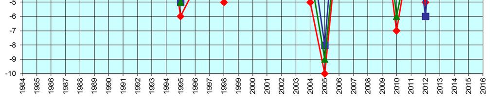
3 Figure 2: Difference plus or minus between the number of observed hurricanes, selected outlook. Figure 3: Difference plus or minus between the number of observed hurricane days, selected outlook


4 Figure 4: Difference plus or minus between the number of observed tropical storm days, selected outlook
5 Table 1: Summary of Outlook Comparisons 1984 to 2016 [33 Years] CSU WRC CSI OUTLOOK CLIMATOLOGY OUTLOOK Named Storms in storm 9 Years 5 Years 8 Years Hurricanes in storm 14 Years 10 Years 12 Years Hurricane Days Atlantic within 5 days 12 Years 7 Years 9 Years Tropical Storms days in Atlantic within 10 days 15 Years 9 Years 11 Years In 2000, NOAA started making Annual Atlantic Hurricane Outlooks. Also at that time with better observing techniques, it seems that the number of observed storms increased. So the decision was made to increase the total number of named tropical storms by 3 storms each year and the number of hurricanes by one after This would change the numbers for the WRC CSI outlook by the following, see Table 2. Table 2: Corrected WRC CSI Outlook to Increase Named Storms and Hurricanes after 1999 CSU WRC CSI OUTLOOK CLIMATOLOGY OUTLOOK Named Storms in storm 13 Years 4 Years 9 Years Hurricanes in storm 15 Years 9 Years 12 Years
6 WRC CSI was developed to predict which section of the United States coast line had the highest risk of experiencing a landfall of a tropical storm or hurricane each year. Below is the outlook from 2017 to When using this outlook, remember that it states which section of the coast has the highest risk, each year each section of the coast has a risk of experiencing landfall of a tropical cyclone. Year Coast No. of Cyclones No, Hurricanes Hurricane Days Tropical Storm Days 2017 Texas 70% W. Florida 70% Louisiana to Alabama 75% Louisiana to Alabama 75% Georgia to N. Carolina 90% Louisiana to Alabama 70% W. Florida 90% Louisiana to Alabama 90% W Florida 90% Georgia to N. Carolina 60% Louisiana to Alabama 60% W. Florida 60% Louisiana to Alabama 70% W. Florida 70% W. Florida 80% NE Coast 70% Georgia to N Carolina 70% W. Florida 70% Texas 70% W. Florida 70% Georgia to N. Carolina 90% Louisiana to Alabama 70% W. Florida 90% Louisiana to Alabama 90% W. Florida 90% Georgia to N. Carolina 60% Louisiana to Alabama 60% W. Florida 60% Louisiana to Alabama 70% W. Florida 70% W. Florida 80% NE Coast 70% Georgia to N Carolina 70% W. Florida 70% Texas 70% W. Florida 70%
Weather Research Center
 Weather Research Center 3227 Audley Houston, Texas 77098 Phone: 713-529-3076 Fax: 713-528-3538 E-mail: wrc@wxresearch.org Press Release For Immediate Release November 29, 2005 For Information Contact:
2006 ATLANTIC HURRICANE SUMMARY. Weather Research Center Houston, Texas
 2006 ATLANTIC HURRICANE SUMMARY Weather Research Center Houston, Texas Weather Research Center 5104 Caroline Houston, Texas 77004 Phone: 713-529-3076 Fax: 713-528-3538 E-mail: wrc@wxresearch.org 2006 Atlantic
COLORADO STATE UNIVERSITY FORECAST OF ATLANTIC HURRICANE ACTIVITY FROM AUGUST 16 AUGUST 29, 2013
 COLORADO STATE UNIVERSITY FORECAST OF ATLANTIC HURRICANE ACTIVITY FROM AUGUST 16 AUGUST 29, 2013 We expect that the next two weeks will be characterized by above-average amounts (greater than 130 percent)
COLORADO STATE UNIVERSITY FORECAST OF ATLANTIC HURRICANE ACTIVITY FROM AUGUST 4-17, 2015
 COLORADO STATE UNIVERSITY FORECAST OF ATLANTIC HURRICANE ACTIVITY FROM AUGUST 4-17, 2015 We expect that the next two weeks will be characterized by below-average amounts (
COLORADO STATE UNIVERSITY FORECAST OF ATLANTIC HURRICANE ACTIVITY FROM AUGUST 17 AUGUST 30, 2012
 COLORADO STATE UNIVERSITY FORECAST OF ATLANTIC HURRICANE ACTIVITY FROM AUGUST 17 AUGUST 30, 2012 We expect that the next two weeks will be characterized by above-average amounts (greater than 130 percent)
COLORADO STATE UNIVERSITY FORECAST OF ATLANTIC HURRICANE ACTIVITY FROM SEPTEMBER 25 OCTOBER 8, 2014
 COLORADO STATE UNIVERSITY FORECAST OF ATLANTIC HURRICANE ACTIVITY FROM SEPTEMBER 25 OCTOBER 8, 2014 We expect that the next two weeks will be characterized by below-average amounts (
COLORADO STATE UNIVERSITY FORECAST OF ATLANTIC HURRICANE ACTIVITY FROM OCTOBER 13 OCTOBER 26, 2017
 COLORADO STATE UNIVERSITY FORECAST OF ATLANTIC HURRICANE ACTIVITY FROM OCTOBER 13 OCTOBER 26, 2017 We expect that the next two weeks will be characterized by above-normal hurricane activity. (as of 13
COLORADO STATE UNIVERSITY FORECAST OF ATLANTIC HURRICANE ACTIVITY FROM SEPTEMBER 1 SEPTEMBER 14, 2015
 COLORADO STATE UNIVERSITY FORECAST OF ATLANTIC HURRICANE ACTIVITY FROM SEPTEMBER 1 SEPTEMBER 14, 2015 We expect that the next two weeks will be characterized by below-average amounts (
April Forecast Update for Atlantic Hurricane Activity in 2018
 April Forecast Update for Atlantic Hurricane Activity in 2018 Issued: 5 th April 2018 by Professor Mark Saunders and Dr Adam Lea Dept. of Space and Climate Physics, UCL (University College London), UK
August Forecast Update for Atlantic Hurricane Activity in 2015
 August Forecast Update for Atlantic Hurricane Activity in 2015 Issued: 5 th August 2015 by Professor Mark Saunders and Dr Adam Lea Dept. of Space and Climate Physics, UCL (University College London), UK
COLORADO STATE UNIVERSITY FORECAST OF ATLANTIC HURRICANE ACTIVITY FROM AUGUST 14 AUGUST 27, 2014
 COLORADO STATE UNIVERSITY FORECAST OF ATLANTIC HURRICANE ACTIVITY FROM AUGUST 14 AUGUST 27, 2014 We expect that the next two weeks will be characterized by below-average amounts (less than 70 percent)
April Forecast Update for Atlantic Hurricane Activity in 2016
 April Forecast Update for Atlantic Hurricane Activity in 2016 Issued: 5 th April 2016 by Professor Mark Saunders and Dr Adam Lea Dept. of Space and Climate Physics, UCL (University College London), UK
COLORADO STATE UNIVERSITY FORECAST OF ATLANTIC HURRICANE ACTIVITY FROM SEPTEMBER 28 OCTOBER 11, 2011
 COLORADO STATE UNIVERSITY FORECAST OF ATLANTIC HURRICANE ACTIVITY FROM SEPTEMBER 28 OCTOBER 11, 2011 We expect that the next two weeks will be characterized by below-average amounts (less than 70 percent)
July Forecast Update for North Atlantic Hurricane Activity in 2018
 July Forecast Update for North Atlantic Hurricane Activity in 2018 Issued: 5 th July 2018 by Professor Mark Saunders and Dr Adam Lea Dept. of Space and Climate Physics, UCL (University College London),
April Forecast Update for North Atlantic Hurricane Activity in 2019
 April Forecast Update for North Atlantic Hurricane Activity in 2019 Issued: 5 th April 2019 by Professor Mark Saunders and Dr Adam Lea Dept. of Space and Climate Physics, UCL (University College London),
Pre-Season Forecast for North Atlantic Hurricane Activity in 2018
 Pre-Season Forecast for North Atlantic Hurricane Activity in 2018 Issued: 30 th May 2018 by Professor Mark Saunders and Dr Adam Lea Dept. of Space and Climate Physics, UCL (University College London),
COLORADO STATE UNIVERSITY FORECAST OF ATLANTIC HURRICANE ACTIVITY FROM AUGUST 31 SEPTEMBER 13, 2012
 COLORADO STATE UNIVERSITY FORECAST OF ATLANTIC HURRICANE ACTIVITY FROM AUGUST 31 SEPTEMBER 13, 2012 We expect that the next two weeks will be characterized by average amounts (70-130 percent) of activity
August Forecast Update for Atlantic Hurricane Activity in 2012
 August Forecast Update for Atlantic Hurricane Activity in 2012 Issued: 6 th August 2012 by Professor Mark Saunders and Dr Adam Lea Dept. of Space and Climate Physics, UCL (University College London), UK
August Forecast Update for Atlantic Hurricane Activity in 2016
 August Forecast Update for Atlantic Hurricane Activity in 2016 Issued: 5 th August 2016 by Professor Mark Saunders and Dr Adam Lea Dept. of Space and Climate Physics, UCL (University College London), UK
COLORADO STATE UNIVERSITY FORECAST OF ATLANTIC HURRICANE ACTIVITY FROM AUGUST 30 SEPTEMBER 12, 2013
 COLORADO STATE UNIVERSITY FORECAST OF ATLANTIC HURRICANE ACTIVITY FROM AUGUST 30 SEPTEMBER 12, 2013 We expect that the next two weeks will be characterized by average amounts (70-130 percent) of activity
PRMS WHITE PAPER 2014 NORTH ATLANTIC HURRICANE SEASON OUTLOOK. June RMS Event Response
 PRMS WHITE PAPER 2014 NORTH ATLANTIC HURRICANE SEASON OUTLOOK June 2014 - RMS Event Response 2014 SEASON OUTLOOK The 2013 North Atlantic hurricane season saw the fewest hurricanes in the Atlantic Basin
COLORADO STATE UNIVERSITY FORECAST OF ATLANTIC HURRICANE ACTIVITY FROM SEPTEMBER 27-OCTOBER 10, 2018
 COLORADO STATE UNIVERSITY FORECAST OF ATLANTIC HURRICANE ACTIVITY FROM SEPTEMBER 27-OCTOBER 10, 2018 We expect that the next two weeks will be characterized by above-normal amounts of hurricane activity,
2013 ATLANTIC HURRICANE SEASON OUTLOOK. June RMS Cat Response
 2013 ATLANTIC HURRICANE SEASON OUTLOOK June 2013 - RMS Cat Response Season Outlook At the start of the 2013 Atlantic hurricane season, which officially runs from June 1 to November 30, seasonal forecasts
July Forecast Update for Atlantic Hurricane Activity in 2016
 July Forecast Update for Atlantic Hurricane Activity in 2016 Issued: 5 th July 2016 by Professor Mark Saunders and Dr Adam Lea Dept. of Space and Climate Physics, UCL (University College London), UK Forecast
COLORADO STATE UNIVERSITY FORECAST OF ATLANTIC HURRICANE ACTIVITY FROM SEPTEMBER 15 SEPTEMBER 28, 2015
 COLORADO STATE UNIVERSITY FORECAST OF ATLANTIC HURRICANE ACTIVITY FROM SEPTEMBER 15 SEPTEMBER 28, 2015 We expect that the next two weeks will be characterized by below-average amounts (
Preliminary Assessment of 2017 Atlantic Hurricane Season. Phil Klotzbach. Department of Atmospheric Science. Phil Klotzbach
 Atlantic Basin Basin Tropical Seasonal Cyclone Hurricane Climatology Prediction and Preliminary Assessment of 2017 Atlantic Hurricane Season Phil Klotzbach Department of Atmospheric Science Colorado Phil
July Forecast Update for Atlantic Hurricane Activity in 2017
 July Forecast Update for Atlantic Hurricane Activity in 2017 Issued: 4 th July 2017 by Professor Mark Saunders and Dr Adam Lea Dept. of Space and Climate Physics, UCL (University College London), UK Forecast
COLORADO STATE UNIVERSITY FORECAST OF ATLANTIC HURRICANE ACTIVITY FROM AUGUST 2 AUGUST 15, 2013
 COLORADO STATE UNIVERSITY FORECAST OF ATLANTIC HURRICANE ACTIVITY FROM AUGUST 2 AUGUST 15, 2013 We expect that the next two weeks will be characterized by below-average amounts (
Extreme Rainfall in the Southeast U.S.
 Extreme Rainfall in the Southeast U.S. David F. Zierden Florida State Climatologist Center for Ocean Atmospheric Prediction Studies The Florida State University March 7, 2016 Causes of Extreme Rainfall
Are You Ready For Hurricane Season? 2018 Hurricane Talk B Y : S T O R M T E A M 8 M E T E O R O L O G I S T J U L I E P H I L L I P S
 Are You Ready For Hurricane Season? 2018 Hurricane Talk B Y : S T O R M T E A M 8 M E T E O R O L O G I S T J U L I E P H I L L I P S About Me I am Currently a Weekday Meteorologist at WFLA Channel 8.
2016 Hurricane Season Preview
 2016 Hurricane Season Preview Eric Uhlhorn, Ph.D. 1 2 Recap of 2015 Hurricane Season - El Niño played a significant role in activity - Atlantic activity was slightly below normal 11 named storms, 4 hurricanes,
A Statistical-Dynamical Seasonal Forecast of US Landfalling TC Activity
 A Statistical-Dynamical Seasonal Forecast of US Landfalling TC Activity Johnny Chan and Samson K S Chiu Guy Carpenter Asia-Pacific Climate Impact Centre City University of Hong Kong Research sponsored
DYNAMIC POSITIONING CONFERENCE October 7-8, Operations. Using GIS to Understand Hurricane Windfields in the Gulf of Mexico
 Return to Session Directory DYNAMIC POSITIONING CONFERENCE October 7-8, 2008 Operations Using GIS to Understand Hurricane Windfields in the Gulf of Mexico Jill F. Hasling and Maureen T. Maiuri Weather
The Worst Places for Hurricanes
 The Worst Places for Hurricanes Hurricane Hotspots By now, everyone knows that the last two hurricane seasons have been particularly severe. Severe yes, but compared to what? Hurricane experts are saying
COLORADO STATE UNIVERSITY FORECAST OF ATLANTIC HURRICANE ACTIVITY FROM SEPTEMBER 13-SEPTEMBER 26, 2018
 COLORADO STATE UNIVERSITY FORECAST OF ATLANTIC HURRICANE ACTIVITY FROM SEPTEMBER 13-SEPTEMBER 26, 2018 We expect that the next two weeks will be characterized by near-normal amounts of hurricane activity.
COLORADO STATE UNIVERSITY FORECAST OF ATLANTIC HURRICANE ACTIVITY FROM AUGUST 16 29, 2018
 COLORADO STATE UNIVERSITY FORECAST OF ATLANTIC HURRICANE ACTIVITY FROM AUGUST 16 29, 2018 We expect that the next two weeks will be characterized by below-normal amounts of hurricane activity. (as of 16
WEEKEND WEATHER OUTLOOK BELIZE, CENTRAL AMERICA
 WEEKEND WEATHER OUTLOOK BELIZE, CENTRAL AMERICA PERIOD: Friday, July 13 until Monday, July 16, 2012 DATE ISSUED: Friday, June 13, 2012, 9:00 am RFrutos SYNOPSIS: A weak pressure gradient over the NW Caribbean
The 2014 Atlantic Hurricane Season. What is New and What to Expect. Mark Chambers President & CEO ImpactWeather, Inc.
 The 2014 Atlantic Hurricane Season What is New and What to Expect Mark Chambers President & CEO ImpactWeather, Inc. Hurricane Climatology for the Gulf of Mexico A Look back at 2013 The outlook for this
KCC White Paper: The 100 Year Hurricane. Could it happen this year? Are insurers prepared? KAREN CLARK & COMPANY. June 2014
 KAREN CLARK & COMPANY KCC White Paper: The 100 Year Hurricane Could it happen this year? Are insurers prepared? June 2014 Copyright 2014 Karen Clark & Company The 100 Year Hurricane Page 1 2 COPLEY PLACE
At the Midpoint of the 2008
 At the Midpoint of the 2008 Atlantic Hurricane Season Editor s note: It has been an anxious couple of weeks for those with financial interests in either on- or offshore assets in the Gulf of Mexico and
RMS Medium Term Perspective on Hurricane Activity
 RMS Medium Term Perspective on Hurricane Activity Dr. Manuel Lonfat Florida Commission on Hurricane Loss Projection Methodology Workshop Tallahassee, July 27 2006 Agenda Multiyear autocorrelation of Atlantic,
Weather Outlook for Spring and Summer in Central TX. Aaron Treadway Meteorologist National Weather Service Austin/San Antonio
 Weather Outlook for Spring and Summer in Central TX Aaron Treadway Meteorologist National Weather Service Austin/San Antonio Outline A Look Back At 2014 Spring 2015 So Far El Niño Update Climate Prediction
2A.5 A Climatology of Catastrophic Flooding in Texas From Tropical Cyclones Derek Ortt and Cameron Self StormGeo Inc, Houston, Texas
 2A.5 A Climatology of Catastrophic Flooding in Texas From Tropical Cyclones Derek Ortt and Cameron Self StormGeo Inc, Houston, Texas 1. INTRODUCTION In August 2017, Hurricane Harvey produced catastrophic
Climate Variability and El Niño
 Climate Variability and El Niño David F. Zierden Florida State Climatologist Center for Ocean Atmospheric Prediction Studies The Florida State University UF IFAS Extenstion IST January 17, 2017 The El
2014 Emergency Preparedness Conference. Tuesday, June 3, 2014 The Wildwoods Convention Center 4501 Boardwalk Wildwood, New Jersey 08260
 2014 Emergency Preparedness Conference Tuesday, June 3, 2014 The Wildwoods Convention Center 4501 Boardwalk Wildwood, New Jersey 08260 A Look back at Winter 2013-2014 A Look ahead to the 2014 Hurricane
FORECAST OF ATLANTIC SEASONAL HURRICANE ACTIVITY AND LANDFALL STRIKE PROBABILITY FOR 2015
 FORECAST OF ATLANTIC SEASONAL HURRICANE ACTIVITY AND LANDFALL STRIKE PROBABILITY FOR 2015 We continue to foresee a below-average 2015 Atlantic hurricane season. A moderate to strong El Niño is underway,
Homework 9: Hurricane Forecasts (adapted from Pipkin et al.)
") November 2010 MAR 110 HW9 Hurricane Forecasts 1 Homework 9: Hurricane Forecasts (adapted from Pipkin et al.) Movement of Hurricanes The advance of a tropical storm or hurricane is controlled by the prevailing
November 2010 MAR 110 HW9 Hurricane Forecasts 1 Homework 9: Hurricane Forecasts (adapted from Pipkin et al.) Movement of Hurricanes The advance of a tropical storm or hurricane is controlled by the prevailing
COLORADO STATE UNIVERSITY FORECAST OF ATLANTIC HURRICANE ACTIVITY FROM AUGUST 18-31, 2017
 COLORADO STATE UNIVERSITY FORECAST OF ATLANTIC HURRICANE ACTIVITY FROM AUGUST 18-31, 2017 We expect that the next two weeks will be characterized by above-average amounts (>130%) of activity relative to
Monthly Long Range Weather Commentary Issued: SEPTEMBER 19, 2016 Steven A. Root, CCM, Chief Analytics Officer, Sr. VP,
 Monthly Long Range Weather Commentary Issued: SEPTEMBER 19, 2016 Steven A. Root, CCM, Chief Analytics Officer, Sr. VP, sroot@weatherbank.com SEPTEMBER 2016 Climate Highlights The Month in Review The contiguous
There was a big difference in rainfall patterns during the month of May across the ACF basin. The image to the left indicates either a surplus or
 There was a big difference in rainfall patterns during the month of May across the ACF basin. The image to the left indicates either a surplus or deficit of rainfall for the month. Note that northern reaches
FORECAST OF ATLANTIC SEASONAL HURRICANE ACTIVITY AND LANDFALL STRIKE PROBABILITY FOR 2018
 FORECAST OF ATLANTIC SEASONAL HURRICANE ACTIVITY AND LANDFALL STRIKE PROBABILITY FOR 2018 We have decreased our forecast and now believe that 2018 will have below-average activity. The tropical and subtropical
Monthly Long Range Weather Commentary Issued: NOVEMBER 16, 2015 Steven A. Root, CCM, Chief Analytics Officer, Sr. VP, sales
 Monthly Long Range Weather Commentary Issued: NOVEMBER 16, 2015 Steven A. Root, CCM, Chief Analytics Officer, Sr. VP, sales sroot@weatherbank.com OCTOBER 2015 Climate Highlights The Month in Review The
Climate Outlook through 2100 South Florida Ecological Services Office Vero Beach, FL September 9, 2014
 Climate Outlook through 2100 South Florida Ecological Services Office Vero Beach, FL September 9, 2014 Short Term Drought Map: Short-term (
ATMOSPHERIC MODELLING. GEOG/ENST 3331 Lecture 9 Ahrens: Chapter 13; A&B: Chapters 12 and 13
 ATMOSPHERIC MODELLING GEOG/ENST 3331 Lecture 9 Ahrens: Chapter 13; A&B: Chapters 12 and 13 Agenda for February 3 Assignment 3: Due on Friday Lecture Outline Numerical modelling Long-range forecasts Oscillations
Weekend Outlook Belize, Central America Valid for: Friday until Monday, May 25-28, 2012
 Weekend Outlook Belize, Central America Valid for: Friday until Monday, May 25-28, 2012 RFrutos Synopsis: Conditions this past week improved by Wednesday as a surface low and trough producing the showery
QUALITATIVE DISCUSSION OF ATLANTIC BASIN SEASONAL HURRICANE ACTIVITY FOR 2019
 QUALITATIVE DISCUSSION OF ATLANTIC BASIN SEASONAL HURRICANE ACTIVITY FOR 2019 We provide qualitative discussions of the factors which will determine next year s Atlantic basin hurricane activity with our
Your web browser (Safari 7) is out of date. For more security, comfort and the best experience on this site: Update your browser Ignore
 is out of date. For more security, comfort and the best experience on this site: Update your browser Ignore") Your web browser (Safari 7) is out of date. For more security, comfort and the best experience on this site: Update your browser Ignore Educator Version 2005 HU RRICANE SEASO N Map traces a stormy season
Your web browser (Safari 7) is out of date. For more security, comfort and the best experience on this site: Update your browser Ignore Educator Version 2005 HU RRICANE SEASO N Map traces a stormy season
Plotting Early Nineteenth-Century Hurricane Information
 Vol. 85, No. 20, 18 May 2004 Plotting Early Nineteenth-Century Hurricane Information Brian H. Bossak, U.S. Geological Survey Center for Coastal and Watershed Studies, St. Petersburg, Fla.; and James B.
Monthly Long Range Weather Commentary Issued: APRIL 18, 2017 Steven A. Root, CCM, Chief Analytics Officer, Sr. VP,
 Monthly Long Range Weather Commentary Issued: APRIL 18, 2017 Steven A. Root, CCM, Chief Analytics Officer, Sr. VP, sroot@weatherbank.com MARCH 2017 Climate Highlights The Month in Review The average contiguous
Agricultural Outlook Forum Presented: February 17, 2006 THE SCIENCE BEHIND THE ATLANTIC HURRICANES AND SEASONAL PREDICTIONS
 Agricultural Outlook Forum Presented: February 17, 2006 THE SCIENCE BEHIND THE ATLANTIC HURRICANES AND SEASONAL PREDICTIONS Gerald Bell Meteorologist, National Centers for Environmental Prediction NOAA,
Significant Tornado Risk for AIRGAS Locations East of the Continental Divide. Scott A. Yuknis. Climate Impact Company, Inc.
 Significant Tornado Risk for AIRGAS Locations East of the Continental Divide Scott A. Yuknis Climate Impact Company, Inc. January 2018 1 Significant Tornado Risk for AIRGAS, an Air Liquide Company Locations
Topic 3.2: Tropical Cyclone Variability on Seasonal Time Scales (Observations and Forecasting)
") Topic 3.2: Tropical Cyclone Variability on Seasonal Time Scales (Observations and Forecasting) Phil Klotzbach 7 th International Workshop on Tropical Cyclones November 18, 2010 Working Group: Maritza Ballester
Topic 3.2: Tropical Cyclone Variability on Seasonal Time Scales (Observations and Forecasting) Phil Klotzbach 7 th International Workshop on Tropical Cyclones November 18, 2010 Working Group: Maritza Ballester
What s s New for 2009
 What s s New for 2009 Graphical Tropical Weather Outlook becomes operational Special Tropical Disturbance Statement replaced with Special Tropical Weather Outlook Tropical Cyclone Wind Field Graphic becomes
2015 Plymouth Rock Assurance New Jersey Hurricane Preparedness Study
 2015 Plymouth Rock Assurance New Jersey Hurricane Preparedness Study About This Study Tropical storms and hurricanes directly and indirectly impact New Jersey and its 130 miles of Atlantic coastline. Although
Crop / Weather Update
 Crop / Weather Update Corn Crop Condition Percent of Acreage Rated Good or Excellent 85 80 75 70 65 60 55 50 45 As of September 9, USDA rates the crop at 68% good to excellent. The rating is up one point
2015 AIR Hurricane Season Preview
 2015 AIR Hurricane Season Preview Tim Doggett, Ph.D. 1 Agenda Seasonal hurricane forecasts for 2015 Historical perspective on seasonal forecasting Accounting for uncertainty Forecasts for the 2015 Atlantic
WEEKLY WEATHER OUTLOOK BELIZE, CENTRAL AMERICA
 WEEKLY WEATHER OUTLOOK BELIZE, CENTRAL AMERICA PERIOD: Sunday, July 1 until Monday, July 9, 2012 DATE ISSUED: Sunday, July 1, 2012 3:00 pm RFrutos EcoSolutions & Services SYNOPSIS: The features of interest
1C.4 TROPICAL CYCLONE TORNADOES: SYNOPTIC SCALE INFLUENCES AND FORECASTING APPLICATIONS
 1C.4 TROPICAL CYCLONE TORNADOES: SYNOPTIC SCALE INFLUENCES AND FORECASTING APPLICATIONS Daniel J. Cecil and Lori A. Schultz University of Alabama in Huntsville, Huntsville, AL, 35805 1. INTRODUCTION Several
Crop / Weather Update
 Crop / Weather Update Corn Crop Condition Percent of Acreage Rated Good or Excellent 85 80 75 70 65 60 55 50 45 Corn condition this week is the same as the last two weeks in the good/excellent category,
Short-Term Job Growth Impacts of Hurricane Harvey on the Gulf Coast and Texas
 Short-Term Job Growth Impacts of Hurricane Harvey on the Gulf Coast and Texas Keith Phillips & Christopher Slijk Federal Reserve Bank of Dallas San Antonio Branch The views expressed in this presentation
Colorado State University (CSU) Atlantic Hurricane Season Forecast
 Atlantic Hurricane Season Forecast") Colorado State University (CSU) Atlantic Hurricane Season Forecast Dr. Philip Klotzbach of Colorado State University (CSU) has issued his April forecast for the 2018 Atlantic Hurricane Season. The forecast
Colorado State University (CSU) Atlantic Hurricane Season Forecast Dr. Philip Klotzbach of Colorado State University (CSU) has issued his April forecast for the 2018 Atlantic Hurricane Season. The forecast
Observed Climate Variability and Change: Evidence and Issues Related to Uncertainty
 Observed Climate Variability and Change: Evidence and Issues Related to Uncertainty David R. Easterling National Climatic Data Center Asheville, North Carolina Overview Some examples of observed climate
TROPICAL CYCLONES IN A WARMER WORLD
 TROPICAL CYCLONES IN A WARMER WORLD Dr Mark Saunders Benfield Hazard Research Centre Department of Space and Climate Physics University College London Workshop for Under 35s Reinsurance Group 14th October
WEEKLY WEATHER OUTLOOK BELIZE, CENTRAL AMERICA
 WEEKLY WEATHER OUTLOOK BELIZE, CENTRAL AMERICA PERIOD: Sunday, June 17 until Monday, June 25, 2012 DATE ISSUED: Sunday, June 17, 2012; 3:00 pm RFrutos EcoSolutions & Services SYNOPSIS: An upper level trough
Drought Impacts in the Southern Great Plains. Mark Shafer University of Oklahoma Norman, OK
 Drought Impacts in the Southern Great Plains Mark Shafer University of Oklahoma Norman, OK Causes of Drought: Large-Scale, Stationary High Pressure Air rotates clockwise around high pressure steers storms
2004 Hurricane Season: Climate Overview and Lessons Learned
 2004 Hurricane Season: Climate Overview and Lessons Learned Mark Saunders, PhD (Presenter: Milan Simic,, PhD, Benfield) Lead Scientist, Tropical Storm Risk Benfield Hazard Research Centre University College
Hurricane Forecasting Using Regression Modeling
 Hurricane Forecasting Using Regression Modeling Yue Liu, Ashley Corkill, Roger Estep Group 10 Overview v Introduction v Choosing Predictors v Modeling The Hurricane Data v Conclusion and Results Images
HURRICANE Information for the Teacher
 HURRICANE Information for the Teacher This hurricane simulation activity and STELLA model were adapted from materials developed by Jan Mons and Cathy Eaton of the Glynns Integration of Systems Thinking
Continuity in the Face of Hurricanes: What Every Business Needs To Know. Cameron Self, Tropical Meteorologist. StormGeo
 Continuity in the Face of Hurricanes: What Every Business Needs To Know Cameron Self, Tropical Meteorologist. StormGeo A Hurricane is a Big Heat Engine Forming over warm tropical waters, wind speeds range
U.S. Tropical Cyclone Landfall Variability:
 APRIL NOTES AND CORRESPONDENCE U.S. Tropical Cyclone Landfall Variability: STEVEN W. LYONS The Weather Channel, Atlanta, Georgia April and July ABSTRACT Interannual variations in U.S. tropical storm and
Onset of the Rains in 1997 in the Belmopan Area and Spanish Lookout
 Ten day Outlook for Belize Update: Monday Date: 5/18/2015 ECMWF and NOAA Climate Models are projecting an intensifying El Niño through autumn, 2015. Indications are the 2015 El Niño across the tropical
Lessons Learned from Hurricane Harvey and Irma
 EOL Visit to NSF 3 March 2016 Lessons Learned from Hurricane Harvey and Irma Wen-Chau Lee National Center for Atmospheric Research 23 November 2017 Outline: Meteorological elements of the active 2017 Atlantic
2015 Hurricane Season BY: STORM TEAM 8 METEOROLOGIST JULIE PHILLIPS
 2015 Hurricane Season BY: STORM TEAM 8 METEOROLOGIST JULIE PHILLIPS FORECAST COLORADO STATE UNIVERSITY FORECAST IS CALLING FOR ONE OF THE LEAST ACTIVE SEASONS SINCE THE MID 20 TH CENTURY! THE OFFICIAL
TSR TROPICAL STORM TRACKER LAUNCH
 TSR TROPICAL STORM TRACKER LAUNCH The Old Library, Lloyd s s of London Friday 30th May 2003 10.30am - 11.30am Tropical Storm Risk (TSR) Founded in 2000, Tropical Storm Risk (TSR) offers a leading resource
Module 11: Meteorology Topic 6 Content: Severe Weather Notes
 Severe weather can pose a risk to you and your property. Meteorologists monitor extreme weather to inform the public about dangerous atmospheric conditions. Thunderstorms, hurricanes, and tornadoes are
Mixed Review Write an equation for each problem. Then solve the equation. 1. The difference between 70 and a number is 2. A number minus 13 is 1.
 1 of 12 2/23/2009 4:28 PM Name Mixed Review Write an equation for each problem. Then solve the equation. 1. The difference between 70 and a number is 2. A number minus 13 is 1. 66. 3. A number multiplied
5-3 Solving Multi-Step Inequalities. Solve each inequality. Graph the solution on a number line b 1 11 SOLUTION: The solution set is {b b 2}.
 Solve each inequality. Graph the solution on a number line. 12. 5b 1 11 14. 9 m + 7 The solution set is {b b 2}. {b b 2} The solution set is {m m 40}. 13. 21 > 15 + 2a {m m 40} 15. 13 > 6 The solution
2006 & 2007 Pre-Hurricane Scenario Analyses
 2006 & 2007 Pre-Hurricane Scenario Analyses Executive Summary May 2007 Page 1 OF X FOR OFFICIAL USE ONLY 4 Public Availability to be Determined Under 5 U.S.C. 552 NOTE: Limited Distribution. Release of
Comments by William M. Gray (Colorado State University) on the recently published paper in Science by Webster, et al
 on the recently published paper in Science by Webster, et al") Comments by William M. Gray (Colorado State University) on the recently published paper in Science by Webster, et al., titled Changes in tropical cyclone number, duration, and intensity in a warming environment
Comments by William M. Gray (Colorado State University) on the recently published paper in Science by Webster, et al., titled Changes in tropical cyclone number, duration, and intensity in a warming environment
Colorado State University (CSU) Atlantic Hurricane Season Forecast
 Atlantic Hurricane Season Forecast") Colorado State University (CSU) Atlantic Hurricane Season Forecast Dr. Philip Klotzbach of Colorado State University (CSU) has issued his latest forecast for the Atlantic Hurricane Season. The forecast
Colorado State University (CSU) Atlantic Hurricane Season Forecast Dr. Philip Klotzbach of Colorado State University (CSU) has issued his latest forecast for the Atlantic Hurricane Season. The forecast
ESCI 1010 Lab 7 Hurricanes (AKA: Typhoons, Cyclones)
") ESCI 1010 Lab 7 Hurricanes (AKA: Typhoons, Cyclones) Before Lab: Review pages 328-361 in your Weather and Climate textbook. Please pay special attention to the sections entitled: Hurricanes around the
ESCI 1010 Lab 7 Hurricanes (AKA: Typhoons, Cyclones) Before Lab: Review pages 328-361 in your Weather and Climate textbook. Please pay special attention to the sections entitled: Hurricanes around the
2017 Hurricane Season and Beyond
 2017 Hurricane Season and Beyond Ken Graham National Hurricane Center Building a Weather-Ready Nation Much of U.S. Coast Saw Tropical Wind Watches or Warnings 2017 Hurricane Season Facts and Figures 7th
Weathernews Looks Back at 2015: A Year of Storms. Powerful Typhoons Occurred with Changing Patterns in El Niño Years
 NEWS RELEASE January 27th, 2016 Weathernews Looks Back at 2015: A Year of Storms Powerful Typhoons Occurred with Changing Patterns in El Niño Years Weathernews Inc. (Chiba, Japan; Chihito Kusabiraki/CEO)
P Hurricane Danielle Tropical Cyclogenesis Forecasting Study Using the NCAR Advanced Research WRF Model
 P1.2 2004 Hurricane Danielle Tropical Cyclogenesis Forecasting Study Using the NCAR Advanced Research WRF Model Nelsie A. Ramos* and Gregory Jenkins Howard University, Washington, DC 1. INTRODUCTION Presently,
A Climatology of Landfalling Hurricane Central Pressures Along the Gulf of Mexico Coast
 A Climatology of Landfalling Hurricane Central Pressures Along the Gulf of Mexico Coast David H. Levinson NOAA National Climatic Data Center Asheville, NC Peter J. Vickery Applied Research Associates,
Communicating Hurricane Threats and Impacts on a National Scale. Daniel Brown Warning Coordination Meteorologist National Hurricane Center
 Communicating Hurricane Threats and Impacts on a National Scale Daniel Brown Warning Coordination Meteorologist National Hurricane Center New NWS Products to Help Communicate Potential Impacts New probabilistic
TROPICAL CYCLONE TORNADOES,
 11C.5 COMPOSITE DISTRIBUTIONS AND ANALYSIS OF TROPICAL CYCLONE TORNADOES, 1950-2005 Lori A.Schultz and Dr. Daniel J. Cecil 1 University of Alabama at Huntsville, Huntsville, Alabama 1 INTRODUCTION Although
Crop / Weather Update
 Crop / Weather Update The next will be published November 13, 2018, due to the Veteran s Day holiday on Monday. Corn Harvesting Progress 100% 90% 80% 70% 60% 50% 40% 30% 20% 10% 0% 9/9 9/16 9/23 9/30 10/7
The 2005 North Atlantic Hurricane Season A Climate Perspective
 The 2005 North Atlantic Hurricane Season A Climate Perspective Gerald Bell 1, Eric Blake 2, Chris Landsea 2, Kingtse Mo 1, Richard Pasch 2, Muthuvel Chelliah 1, Stanley Goldenberg 3 1 Climate Prediction
Business Preparedness and Hurricane Risk
 Business Preparedness and Hurricane Risk Hurricanes are one of the more predictable natural disasters compared to events such as earthquakes, wildfires and tornadoes. Meteorologists gather data to predict