Submitted to Central Coalfields Limited BHURKUNDA OCP, CCL
|
|
|
- Meryl Paul
- 5 years ago
- Views:
Transcription
1
 based on Satellite Data for the Year 2013 BHURKUNDA OCP, CCL Submitted to Central Coalfields Limited March")
2 Land Restoration / Reclamation Monitoring of Open Cast Coal Mines of Central Coalfields Limited producing less than 5 m cu m. (Coal+ OB) based on Satellite Data for the Year 2013 BHURKUNDA OCP, CCL Submitted to Central Coalfields Limited March 2014
3 Land Restoration / Reclamation Monitoring of Open Cast Coal Mines of Central Coalfields Limited producing less than 5 m cu m. (Coal+ OB) based on Satellite Data for the Year 2013 March 2014 Remote Sensing Cell Geomatics Division CMPDI, Ranchi i
4 Document Control Sheet (1) Job No. RSC/ (2) Publication Date March 2014 (3) Number of Pages 34 (4) Number of Figures 13 (5) Number of Tables 02 (6) Number of Plates 11 (7) Title of Report Land Restoration / Reclamation Monitoring of Open Cast Mines of Central Coalfields Ltd producing Less than 5 million cu.m. (OB+ Coal) Based on Satellite Data for the Year 2013 (8) Aim of the Report To prepare land use/cover map of leasehold area of 11 opencast mine projects based on high resolution satellite data (IRS-R2-L4MX) of the year 2013 using digital image processing technique. (9) Executing Unit Remote Sensing Cell, Geomatics Division, Central Mine Planning & Design Institute Limited, Gondwana Place, Kanke Road, Ranchi (10) User Agency Central Coalfields Ltd., Ranchi, Jharkhand. (11) Author Priyanka Bhatta, Assistant Manager (RSC) (12) Security Restriction Restricted Circulation (13) No. of Copies 5 (14) Distribution Statement Official ii
5 CONTENTS Sl. No. Description Page No. Executive Summary Background Objective Methodology Land Reclamation in Central Coalfields Limited 08 List of Tables Table-1 Project wise Land Reclamation Status 02 Table-2 Area Statistics of Land Use Classes in OC Mines 09 List of Plates Plate-1 Land Use Map of Ara OCP 11 Plate-2 Land Use Map of Bhurkunda OCP 12 Plate-3 Land Use Map of Pichri OCP 13 Plate-4 Land Use Map of Pindra OCP 14 Plate-5 Land Use Map of Sirka OCP 15 Plate-6 Land Use Map of Dhori OCP 16 Plate-7 Land Use Map of Bokaro OCP 17 Plate-8 Land Use Map of Kargali OCP 18 Plate-9 Land Use Map of Rajhara OCP 14 Plate-10 Land Use Map of Religera OCP 20 Plate-11 Land Use Map of Sarubera OCP 21 List of Figures Figure-1: Bar- chart of Project wise Land Reclamation Status 03 Figure-2: Methodology of Land Reclamation Monitoring 05 Figure-3: Bar-Chart of Land Reclamation Status of Ara OCP 22 Figure-4: Bar-Chart of Land Reclamation Status of Bhurkunda OCP iii
6 Figure-5: Bar-Chart of Land Reclamation Status of Pichri OCP 23 Figure-6: Bar-Chart of Land Reclamation Status of Pindra OCP 23 Figure-7: Bar-Chart of Land Reclamation Status of Sirka OCP 24 Figure-8: Bar-Chart of Land Reclamation Status of Dhori OCP 24 Figure-9: Bar-Chart of Land Reclamation Status of Bokaro OCP 25 Figure-10: Bar-Chart of Land Reclamation Status of Kargali OCP 25 Figure-11: Bar-Chart of Land Reclamation Status of Rajhara OCP 26 Figure-12: Bar-Chart of Land Reclamation Status of Religera OCP 26 Figure-13: Bar-Chart of Land Reclamation Status of Sarubera OCP 27 List of Photographs Photo-1: Plantation on OB Dump (Ara OCP) 28 Photo-2: Plantation on OB Dump (Bhurkunda OCP) 28 Photo-3: Plantation on OB Dump (Pichri OCP) 29 Photo-4: Plantation on OB Dump (Sarubera OCP) 29 Photo-5: Plantation on OB Dump (Bokaro OCP) 30 Photo-6: Plantation on OB Dump (Bokaro OCP) iv
7 Executive summary 1.0 Project Land restoration/reclamation monitoring of 11 opencast coal mines of Central Coalfields Ltd. (CCL) producing less than 5 million cu. m. (Coal+OB) per year based on satellite data on every three year basis. 2.0 Objective Objective of the land restoration/reclamation monitoring is to assess the area of backfilled, plantation, social forestry, active mining area, water bodies, and distribution of wasteland, agricultural land and forest land in the leasehold area of the various opencast projects. This will help in assessing the progressive status of mined out land reclamation and to take up remedial measures, if any, required for environmental protection. 3.0 Salient Findings Out of the total mine leasehold area of hectares of the 11 OC projects Viz. Ara, Bhurkunda, Pichri, Pindra, Sirka, Dhori, Bokaro, Kargali, Rajhara, Religera and Sarubera considered for monitoring during year 2013; total excavated area is only hec. Out of which ha area (41.41%) has been planted, ha area (28.76%) has been backfilled and ha area (29.83%) is under active mining. It is evident from the analysis that 70.17% area of the OC projects have already been reclamed and balance 29.83% area is under active mining. Project wise details are given intable-1 & Fig.-1. Of the total area reclamed by CCL, 41.41% is under biological reclamation (plantation) and 28.76% is under technical reclamation. Out of 11 projects of CCL, Bokaro OCP ranks on top for land reclamation (83.35%) followed by Bhurkunda OCP (78.57%) and Kargali OCP (76.54%)
8 Table - 1 Sl. No. Name Project Projectwise Land Reclamation Status in Opencast Projects of CCL based on Satellite Data of the year 2013 Leasehold (i) (% Calculated in terms of Total Excavated Area) Plantation/ Vegetation Under Backfilling Active Mining Total Excavated Area (Area in Hectares) Total Area under Reclamation (ii) (iii) (iv) (ii+iii+iv) (ii+iii) Ara Bhurkund a Pichri Pindra Sirka Dhori Bokaro Kargali Rajhara Religera Sarubera TOTAL (CCL)

9 Figure 1: Project wise status of Land Reclamation in CCL for the year
10 1.0 Background 1.1 Land is the most important natural resource which embodies soil, water, flora, fauna and total ecosystem. All human activities are based on the land which is the scarcest natural resource in our country. Mining is a site specific industry and it could not be shifted anywhere else from the location where mineral occurs. It is a fact that surface mining activities do affect the land environment due to ground breaking. Therefore, there is an urgent need to reclame and restore the mined out land for its productive use for sustainable development of mining. This will not only mitigate environment for land acquisition by coal companies in future. 1.2 Keeping above in view, M/s Coal India Ltd. (CIL) issued a work order vide letter no. CIL/WBP/Env/2011/4706 dated for monitoring of opencast mines of less than 5 million m3 per annum capacity (Coal + OB) from the year 2012 at intervals of three years. The result of land reclamation status of all such mines is to be published on the website of CIL, ( CMPDI,( and the concerned coal companies in public domain. Detailed reports are to be submitted to Coal India and respective subsidiaries. 1.3 Land reclamation monitoring of all opencast coal mining projects would also comply the statutory requirements of Ministry of Environment & Forest (MoEF). Such monitoring would not only facilitate in taking timely mitigation measures against environmental degradation, but would also enable coal companies to utilize the reclaimed land for larger socio-economic benefits in a planned way. 1.4 Present report is embodying the finding of the study based on satellite data of the year 2013 carried out for 11 OC projects of Central Coalfields Ltd. Producing less than 5 m.c.m (Coal + OB) per annum

11 2.0 Objective Objective of the land reclamation/restoration monitoring is to assess the area of backfilled plantation, OB dumps, social forestry, active mining area, settlements and water bodies, distribution of wasteland, agricultural land and forest land in the leasehold area of the project. This is an important step taken up for assessing the progressive status of mined land reclamation and for taking up remedial measures, if any, required, required for environmental protection. 3.0 Methodology There are number of steps involved between raw satellite data procurement and preparation of final map. National Remote Sensing Centre (NRSC), Hyderabad, being the nodal agency for satellite data supply in India, provides raw digital satellite data, which needs further digital image processing for extracting the information and map preparation before uploading the same in the website. Methodology for land reclamation monitoring is given in Fig. 2. Following steps are involved in land reclamation/ restoration monitoring: Figure-2: Methodology of Land Reclamation Monitoring
12 3.1 Data Procurement: After browsing the data quality and date of pass on NRSC site, data order is placed to NRSC. Secondary data like leasehold boundary, topo-sheets are procured for creation of vector database. 3.2 Satellite Data Processing: Satellite data are processed using ERDAS IMAGINE digital image processing s/w v2012. Methodology involves the following major steps: Rectification & Geo-referencing: Inaccuracies in digital imagery may occur due to systematic errors attributed to earth curvature and rotation as well as non-systematic errors attributed to satellite receiving station itself. Raw digital images contain geometric distortions, which make them unusable as maps. Therefore, geo-referencing is required for correction of image data using ground control points (GCP) to male it compatible to SOI topo-sheet. Image Enhancement: To improve the interpretability of the raw data, image enhancement is necessary. Local operations modify the value of each pixel based on brightness value of neighbouring pixels using ERDAS IMAGINE 9.3 s/w and enhance the image quality for interpretation. Training set Selection Training set requires to be selected, so that software can classify the image data accurately. The image data are analysed based on the interpretation keys. These keys are evolved from certain fundamental image elements such as tone/colour, size, shape, texture, pattern, location, association and shadow. Based on the image- elements and other geo-technical elements like land form, drainage pattern and physiography; training sets were selected/identified for each land use/cover class. Field survey was carried out by taking selective traverses in order to collect the ground information (or reference data) so that training sets are selected accurately in the image. This was intended to serve as an aid for classification
13 Classification and Accuracy Assessment Image classification is carried out using the maximum likelihood algorithm. The classification proceeds through the following steps: (a) calculation of statistics [i.e. signature generation] for the identified training areas, and (b) the decision boundary of maximum probability based on the mean vector, variance, covariance and correlation matrix of the pixels. After evaluating the statistical parameters of the training sets, reliability test of training sets are conducted by measuring the statistical separation between the classes that resulted from computing divergence matrix. The overall accuracy of the classification was finally assessed with reference to ground truth data. Area calculation The area of each land use class in the leasehold is determined using ERDAS IMAGINE v2012 s/w and given in table 2. Overlay of Vector database Vector data base created based on secondary dat. Vector layer like railway line, settlements, forest boundary, leasehold boundary, roads, drainage etc. are superimposed on the image as vector layer in the ArcGIS database. Pre-field map preparation Pre-field map is prepared for validation of classification result 3.3 Ground Truthing: Selective ground verification of the land use classes are carried out in the field and necessary corrections if required, are incorporated before map finalization. 3.4 Land reclamation Database on GIS: Land reclamation database is created on GIS platform to identify the temporal changes identified from satellite data of different cut-off dates
14 4.0 Land Reclamation Status of Central Coalfields Ltd. Following 11 OC Projects producing less than 5 million m 3 (Coal +OB) of Central Coalfields Ltd. Have been taken up during the year 2013 for land reclamation monitoring: Ara Bhurkunda Pichri Pindra Sirka Dhori Bokaro Kargali Rajhara Religera Sarubera 4.1 Area statistics of different land use classes present in OC projects in the year 2013 is given in table 2. Land use maps derived from the satellite data is given in Plate No. 1 to 11. Land use statuses are shown in fig and field photographs showing plantation and backfilled area in mining project is shown in Photos Study reveals that 70.17% of excavated area has already been reclaimed by CCL in the OC Projects, out of which 41.41% area has been planted and 28.76% area are backfilled. 4.3 After analyzing the satellite data of the year 2013, it is evident that plantation carried out on backfilled area, OB dumps as well as under social forestry in all the 11 mines of CCL taken for study, has reached 41.41% till now. It can also be seen from table 1 that the total area of reclamation has reached 70.17% till the year

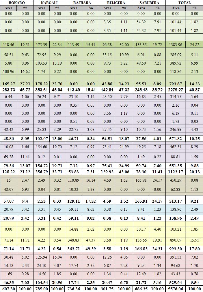
15 Table 2: STATUS OF LAND RECLAMATION IN CENTRAL COALFIELDS LIMITED BASED ON SATELLITE DATA OF THE YEAR

16 CMPDI

17 Plate

18 Plate

19 Plate

20 Plate

21 Plate

22 Plate 6 CMPDI Plate

23 Plate

24 Plate

25 Plate

26 Plate

27 Plate


28 Figure 3 Figure


29 Figure 5 Figure


30 Figure 7 Figure


31 Figure 9 Figure

32 Figure 11 Figure

33 Figure
 Photo")
")
34 Photo 1: Plantation on OB Dump (Ara OCP) Photo 2: Plantation on OB Dump (Bhurkunda OCP)
 Photo")
 561410027")
35 Photo 3: Plantation on OB Dump (Pichri OCP) Photo 4: Plantation on OB Dump (Sarubera OCP)
")

36 Photo 5: Plantation on OB Dump (Bokaro OCP) Photo 6: Plantation on OB Dump (Bokaro OCP)
37 Central Mine Planning & Design Institute Ltd. (A Subsidiary of Coal India Ltd.) Gondwana Place, Kanke Road, Ranchi ,India Phone : ( ) , , , Fax ( ) , cmpdi2@hub.nic.in, cmpdihq@cmpdi.co.in website : cmpdi.co.in
Submitted to: Central Coalfields Limited Ranchi, Jharkhand. Ashoka & Piparwar OCPs, CCL
 Land Restoration / Reclamation Monitoring of more than 5 million cu. m. (Coal + OB) Capacity Open Cast Coal Mines of Central Coalfields Limited Based on Satellite Data for the Year 2013 Ashoka & Piparwar
Coalfields Limited. Based on Satellite Data for the Year Central Coalfields Limited Ranchi, Jharkhand. Submitted to:
 Land Restoration / Reclamation Monitoring of less than 5 m cu. m. (Coal + OB) Capacity Open Cast Coal Mines of Central Coalfields Limited Based on Satellite Data for the Year 2011. N URIMARI (BIRSA) OCP,CCL
Submitted to Western Coalfields Limited. I Inder UG to OC. Kamptee UG to OC
 Land Restoration / Reclamation Monitoring of Open Cast Coal Mines Less than 5 million cu.m. (OB+Coal) of Western Coalfields Ltd. Based on Satellite Data for the Year 2012 I Inder UG to OC Kamptee UG to
WESTERN COALFIELDS LIMITED
 Land Restoration / Reclamation Monitoring of less than 5 million Cu. M. (Coal+OB) Capacity Opencast Coal Mines of Western Coalfields Limited based on Satellite Data for the Year 2014 ERAI RIVER Coal Stock
Land Restoration /Reclamation Monitoring of Opencast Coal Mines of WCL Based On Satellite Data for the Year 2009 CMPDI. A Miniratna Company
 Land Restoration /Reclamation Monitoring of Opencast Coal Mines of WCL Based On Satellite Data for the Year 2009 CMPDI A Miniratna Company Land Restoration /Reclamation Monitoring of Opencast Coal Mines
Land Restoration / Reclamation Monitoring of 50 Opencast Coal Mines of CIL producing more than 5 mcm (Coal+OB) based on Satellite Data for the Year
 based on Satellite Data for the Year") Land Restoration / Reclamation Monitoring of 50 Opencast Coal Mines of CIL producing more than 5 mcm (Coal+OB) based on Satellite Data for the Year 2014-15 Land Restoration / Reclamation Monitoring of
Land Restoration / Reclamation Monitoring of 50 Opencast Coal Mines of CIL producing more than 5 mcm (Coal+OB) based on Satellite Data for the Year 2014-15 Land Restoration / Reclamation Monitoring of
Land Restoration / Reclamation Monitoring of 50 Opencast Coal Mines of CIL producing more than 5 mcm (Coal+OB) based on Satellite Data for the Year
 based on Satellite Data for the Year") Land Restoration / Reclamation Monitoring of 50 Opencast Coal Mines of CIL producing more than 5 mcm (Coal+OB) based on Satellite Data for the Year 2013-14 Land Restoration / Reclamation Monitoring of
Land Restoration / Reclamation Monitoring of 50 Opencast Coal Mines of CIL producing more than 5 mcm (Coal+OB) based on Satellite Data for the Year 2013-14 Land Restoration / Reclamation Monitoring of
REPORT ON LAND USE/ VEGETATION COVER MAPPING OF BANDER COALFIELD OF WCL BASED ON REMOTE SENSING TECHNIQUE USING SATELLITE DATA OF 2012
 REPORT ON LAND USE/ VEGETATION COVER MAPPING OF BANDER COALFIELD OF WCL BASED ON REMOTE SENSING TECHNIQUE USING SATELLITE DATA OF 2012 March 2013 REPORT ON LAND USE/ VEGETATION COVER MAPPING OF BANDER
Land use/land cover Mapping of Jharia Coalfield based on Satellite Data of the Year March-2010
 Land use/land cover Mapping of Jharia Coalfield based on Satellite Data of the Year- 2008 March-2010 Remote Sensing Cell Geomatics Division CMPDI, Ranchi Document Control Sheet (1) Job No. RSC/561410027
Report on Land Use /Vegetation Cover Mapping of Singrauli Coalfield, NCL based on Remote Sensing Technique Year
 Report on Land Use /Vegetation Cover Mapping of Singrauli Coalfield, NCL based on Remote Sensing Technique Year-2012-13 Submitted to COAL INDIA LIMITED September 2012 Document Control Sheet List of Figures
REPORT ON Land use/vegetation cover Mapping of Rajmahal Coalfield based on Satellite data of the year Submitted to Eastern Coalfields Limited
 REPORT ON Land use/vegetation cover Mapping of Rajmahal Coalfield based on Satellite data of the year 2014 Submitted to Eastern Coalfields Limited Land use/vegetation cover Mapping of Rajmahal Coalfield
Report on Land Use / Vegetation Cover Mapping of Ib Valley Coalfield based on Satellite Data for the Year 2017 IB VALLEY COALFIELD
 Report on Land Use / Vegetation Cover Mapping of Ib Valley Coalfield based on Satellite Data for the Year 2017 IB VALLEY COALFIELD Submitted to Mahanadi Coalfields Limited Report on Land Use/ Vegetation
7.1 INTRODUCTION 7.2 OBJECTIVE
 7 LAND USE AND LAND COVER 7.1 INTRODUCTION The knowledge of land use and land cover is important for many planning and management activities as it is considered as an essential element for modeling and
FEBRUARY tis ... Po. III. Cll
 FEBRUARY 2010 ṯs....... ts Po. o Cll ~ ADVSORY BOARD 4 ndigenous knowledge validates GS outcome Purabl Chanda ndian Agricultural Research nstitute, ndia Dato' Dr. Abdul Kadir bin Taib Director General
Vegetation Cover Mapping of Kamptee Coalfield based on Satellite Data for the Year March-2017
 . CMPDI Vegetation Cover Mapping of Kamptee Coalfield based on Satellite Data for the Year- 2016 March-2017 Remote Sensing Cell Geomatics Division CMPDI, Ranchi Job No 5561410027 Page i . CMPDI Document
Abstract: About the Author:
 REMOTE SENSING AND GIS IN LAND USE PLANNING Sathees kumar P 1, Nisha Radhakrishnan 2 1 1 Ph.D Research Scholar, Department of Civil Engineering, National Institute of Technology, Tiruchirappalli- 620015,
INTERNATIONAL JOURNAL OF GEOMATICS AND GEOSCIENCES Volume 2, No 1, 2011
 INTERNATIONAL JOURNAL OF GEOMATICS AND GEOSCIENCES Volume 2, No 1, 2011 Copyright 2010 All rights reserved Integrated Publishing services Research article ISSN 0976 4380 Spatio-Temporal changes of Land
Abstract. TECHNOFAME- A Journal of Multidisciplinary Advance Research. Vol.2 No. 2, (2013) Received: Feb.2013; Accepted Oct.
 Received: Feb.2013; Accepted Oct.") Vol.2 No. 2, 83-87 (2013) Received: Feb.2013; Accepted Oct. 2013 Landuse Pattern Analysis Using Remote Sensing: A Case Study of Morar Block, of Gwalior District, M.P. Subhash Thakur 1 Akhilesh Singh 2
Vol.2 No. 2, 83-87 (2013) Received: Feb.2013; Accepted Oct. 2013 Landuse Pattern Analysis Using Remote Sensing: A Case Study of Morar Block, of Gwalior District, M.P. Subhash Thakur 1 Akhilesh Singh 2
Environmental Impact Assessment Land Use and Land Cover CISMHE 7.1 INTRODUCTION
 7 LAND USE AND LAND COVER 7.1 INTRODUCTION The knowledge of land use and land cover is important for many planning and management activities as it is considered an essential element for modeling and understanding
Overview of Remote Sensing in Natural Resources Mapping
 Overview of Remote Sensing in Natural Resources Mapping What is remote sensing? Why remote sensing? Examples of remote sensing in natural resources mapping Class goals What is Remote Sensing A remote sensing
Investigation of the Effect of Transportation Network on Urban Growth by Using Satellite Images and Geographic Information Systems
 Presented at the FIG Congress 2018, May 6-11, 2018 in Istanbul, Turkey Investigation of the Effect of Transportation Network on Urban Growth by Using Satellite Images and Geographic Information Systems
UNITED NATIONS E/CONF.96/CRP. 5
 UNITED NATIONS E/CONF.96/CRP. 5 ECONOMIC AND SOCIAL COUNCIL Eighth United Nations Regional Cartographic Conference for the Americas New York, 27 June -1 July 2005 Item 5 of the provisional agenda* COUNTRY
A GIS approach to generation of thematic maps to monitor tea plantations: A case study
 Two and a Bud 59(2):41-45, 2012 RESEARCH PAPER. A GIS approach to generation of thematic maps to monitor tea plantations: A case study Minerva Saiki a I and R.M. Bhagat Department of Soils, Tocklai Experimental
International Journal of Intellectual Advancements and Research in Engineering Computations
 ISSN:2348-2079 Volume-5 Issue-2 International Journal of Intellectual Advancements and Research in Engineering Computations Agricultural land investigation and change detection in Coimbatore district by
LAND SUITABILITY STUDY IN LAND DEGRADED AREA DUE TO MINING IN DHANBAD DISTRICT, JHARKHAND.
 LAND SUITABILITY STUDY IN LAND DEGRADED AREA DUE TO MINING IN DHANBAD DISTRICT, JHARKHAND. Saranathan, E a*, Loveson, V.J b. and Victor Rajamanickam, G c a School of Civil Engineering, SASTRA, Thanjavur
1. Introduction. S.S. Patil 1, Sachidananda 1, U.B. Angadi 2, and D.K. Prabhuraj 3
 Cloud Publications International Journal of Advanced Remote Sensing and GIS 2014, Volume 3, Issue 1, pp. 525-531, Article ID Tech-249 ISSN 2320-0243 Research Article Open Access Machine Learning Technique
Application of Remote Sensing Techniques for Change Detection in Land Use/ Land Cover of Ratnagiri District, Maharashtra
 IOSR Journal of Applied Geology and Geophysics (IOSR-JAGG) e-issn: 2321 0990, p-issn: 2321 0982.Volume 3, Issue 6 Ver. II (Nov. - Dec. 2015), PP 55-60 www.iosrjournals.org Application of Remote Sensing
M.C.PALIWAL. Department of Civil Engineering NATIONAL INSTITUTE OF TECHNICAL TEACHERS TRAINING & RESEARCH, BHOPAL (M.P.), INDIA
, INDIA") INVESTIGATIONS ON THE ACCURACY ASPECTS IN THE LAND USE/LAND COVER MAPPING USING REMOTE SENSING SATELLITE IMAGERY By M.C.PALIWAL Department of Civil Engineering NATIONAL INSTITUTE OF TECHNICAL TEACHERS
INVESTIGATIONS ON THE ACCURACY ASPECTS IN THE LAND USE/LAND COVER MAPPING USING REMOTE SENSING SATELLITE IMAGERY By M.C.PALIWAL Department of Civil Engineering NATIONAL INSTITUTE OF TECHNICAL TEACHERS
An Automated Object-Oriented Satellite Image Classification Method Integrating the FAO Land Cover Classification System (LCCS).
.") An Automated Object-Oriented Satellite Image Classification Method Integrating the FAO Land Cover Classification System (LCCS). Ruvimbo Gamanya Sibanda Prof. Dr. Philippe De Maeyer Prof. Dr. Morgan De
An Automated Object-Oriented Satellite Image Classification Method Integrating the FAO Land Cover Classification System (LCCS). Ruvimbo Gamanya Sibanda Prof. Dr. Philippe De Maeyer Prof. Dr. Morgan De
CHAPTER VII FULLY DISTRIBUTED RAINFALL-RUNOFF MODEL USING GIS
 80 CHAPTER VII FULLY DISTRIBUTED RAINFALL-RUNOFF MODEL USING GIS 7.1GENERAL This chapter is discussed in six parts. Introduction to Runoff estimation using fully Distributed model is discussed in first
Report on Land use/vegetation cover Mapping of North and South Karanpura Coalfields based on Satellite Data of the Year 2015
 Report on Land use/vegetation cover Mapping of North and South Karanpura Coalfields based on Satellite Data of the Year 2015 Submitted to Central Coalfields Ltd Ranchi Job No-561410027 [ Page i] Report
GEOMATICS. Shaping our world. A company of
 GEOMATICS Shaping our world A company of OUR EXPERTISE Geomatics Geomatics plays a mayor role in hydropower, land and water resources, urban development, transport & mobility, renewable energy, and infrastructure
Application of Geographical Information System (GIS) tools in watershed analysis
 tools in watershed analysis") Application of Geographical Information System (GIS) tools in watershed analysis Paritosh Gupta 1, Damanjit S Minhas 2, Rajendra M Tamhane 1, A K Mookerjee 2 1.ESRI India New Delhi 2. LEA Associates South
Application of Geographical Information System (GIS) tools in watershed analysis Paritosh Gupta 1, Damanjit S Minhas 2, Rajendra M Tamhane 1, A K Mookerjee 2 1.ESRI India New Delhi 2. LEA Associates South
International Journal of Scientific Research and Reviews
 Case Study Available online www.ijsrr.org ISSN: 2279 0543 International Journal of Scientific Research and Reviews Study on the Pattern of Land Use /Land Cover Change in Sonipat District of NCR, A Block
MALDIVES. Regional Expert Workshop On Land Accounting For SDG Monitoring & Reporting (25-27 th Sept 2017) - Fathimath Shanna, Aishath Aniya -
 - Fathimath Shanna, Aishath Aniya -") MALDIVES Regional Expert Workshop On Land Accounting For SDG Monitoring & Reporting (25-27 th Sept 2017) - Fathimath Shanna, Aishath Aniya - ABOUT MALDIVES Approximately 860 km long and 120 km wide Consists
MALDIVES Regional Expert Workshop On Land Accounting For SDG Monitoring & Reporting (25-27 th Sept 2017) - Fathimath Shanna, Aishath Aniya - ABOUT MALDIVES Approximately 860 km long and 120 km wide Consists
Geospatial Information for Urban Sprawl Planning and Policies Implementation in Developing Country s NCR Region: A Study of NOIDA City, India
 Geospatial Information for Urban Sprawl Planning and Policies Implementation in Developing Country s NCR Region: A Study of NOIDA City, India Dr. Madan Mohan Assistant Professor & Principal Investigator,
A Case Study of Using Remote Sensing Data and GIS for Land Management; Catalca Region
 A Case Study of Using Remote Sensing Data and GIS for Land Management; Catalca Region Dr. Nebiye MUSAOGLU, Dr. Sinasi KAYA, Dr. Dursun Z. SEKER and Dr. Cigdem GOKSEL, Turkey Key words: Satellite data,
Land Administration and Cadastre
 Geomatics play a major role in hydropower, land and water resources and other infrastructure projects. Lahmeyer International s (LI) worldwide projects require a wide range of approaches to the integration
The National Spatial Data Infrastructure of Zambia Shlomi SIVAN, Israel. Key words: National Land Audit, GIS, LIS, Common Spatial Data
 The National Spatial Data Infrastructure of Zambia Shlomi SIVAN, Israel Key words: National Land Audit, GIS, LIS, Common Spatial Data SUMMARY One of Zambia's important challenges is to recognize the title
SOLUTIONS ADVANCED GIS. TekMindz are developing innovative solutions that integrate geographic information with niche business applications.
 ADVANCED GIS SOLUTIONS TekMindz are developing innovative solutions that integrate geographic information with niche business applications. TEK INDZ TM GIS Services Overview At the leading edge of geospatial
Land Use and Land Cover Mapping and Change Detection in Jind District of Haryana Using Multi-Temporal Satellite Data
 Land Use and Land Cover Mapping and Change Detection in Jind District of Haryana Using Multi-Temporal Satellite Data Ravindra Prawasi, M.P. Sharma, T. P. Babu, Om Pal, Saroj, Kirti Yadav, R.S.Hooda Abstract
Progress and Land-Use Characteristics of Urban Sprawl in Busan Metropolitan City using Remote sensing and GIS
 Progress and Land-Use Characteristics of Urban Sprawl in Busan Metropolitan City using Remote sensing and GIS Homyung Park, Taekyung Baek, Yongeun Shin, Hungkwan Kim ABSTRACT Satellite image is very usefully
International Journal of Scientific & Engineering Research, Volume 6, Issue 7, July ISSN
 International Journal of Scientific & Engineering Research, Volume 6, Issue 7, July-2015 1428 Accuracy Assessment of Land Cover /Land Use Mapping Using Medium Resolution Satellite Imagery Paliwal M.C &.
Report for Area Drainage Studies for 1320 MW (2x660 MW) THERMAL POWER PROJECT AT MIRZAPUR, U.P.
 THERMAL POWER PROJECT AT MIRZAPUR, U.P.") Report for Area Drainage Studies for 1320 MW (2x660 MW) THERMAL POWER PROJECT AT MIRZAPUR, U.P. 1. Introduction M/s Welspun Energy Uttar Pradesh Ltd. (WEUPL) is putting up 1320 MW (2 x 660 MW) coal fired
Report for Area Drainage Studies for 1320 MW (2x660 MW) THERMAL POWER PROJECT AT MIRZAPUR, U.P. 1. Introduction M/s Welspun Energy Uttar Pradesh Ltd. (WEUPL) is putting up 1320 MW (2 x 660 MW) coal fired
VILLAGE INFORMATION SYSTEM (V.I.S) FOR WATERSHED MANAGEMENT IN THE NORTH AHMADNAGAR DISTRICT, MAHARASHTRA
 FOR WATERSHED MANAGEMENT IN THE NORTH AHMADNAGAR DISTRICT, MAHARASHTRA") VILLAGE INFORMATION SYSTEM (V.I.S) FOR WATERSHED MANAGEMENT IN THE NORTH AHMADNAGAR DISTRICT, MAHARASHTRA Abstract: The drought prone zone in the Western Maharashtra is not in position to achieve the agricultural
VILLAGE INFORMATION SYSTEM (V.I.S) FOR WATERSHED MANAGEMENT IN THE NORTH AHMADNAGAR DISTRICT, MAHARASHTRA Abstract: The drought prone zone in the Western Maharashtra is not in position to achieve the agricultural
Use of Geospatial data for disaster managements
 Use of Geospatial data for disaster managements Source: http://alertsystemsgroup.com Instructor : Professor Dr. Yuji Murayama Teaching Assistant : Manjula Ranagalage What is GIS? A powerful set of tools
Table 4.1 Images used for the Study. Spatial Resolution (Meter) Resolution (Bits) 30 (For 6th band 120)
 Resolution (Bits) 30 (For 6th band 120)")
Application of Remote Sensing and GIS in Seismic Surveys in KG Basin
 P-318 Summary Application of Remote Sensing and GIS in Seismic Surveys in KG Basin M.Murali, K.Ramakrishna, U.K.Saha, G.Sarvesam ONGC Chennai Remote Sensing provides digital images of the Earth at specific
Remote Sensing and GIS Application in Change Detection Study Using Multi Temporal Satellite
 Cloud Publications International Journal of Advanced Remote Sensing and GIS 2013, Volume 2, Issue 1, pp. 374-378, Article ID Tech-181 ISSN 2320-0243 Case Study Open Access Remote Sensing and GIS Application
EuroGEOSS Protected Areas Pilot
 EuroGEOSS Protected Areas Pilot Max Craglia European Commission Joint Research Centre Part 1: the present MyNatura2000 Mobile app. Awareness raising & volunteered data collection. Natura2000 covers 18%
COAL EXPLORATION & RESOURCES
 COAL EXPLORATION & RESOURCES Chapter-3 3.1 INTRODUCTION Exploration for Coal in the country is carried out in two broad stages i.e. the Regional Exploration and Detailed Exploration. The regional exploration
STEREO ANALYST FOR ERDAS IMAGINE Stereo Feature Collection for the GIS Professional
 STEREO ANALYST FOR ERDAS IMAGINE Stereo Feature Collection for the GIS Professional STEREO ANALYST FOR ERDAS IMAGINE Has Your GIS Gone Flat? Hexagon Geospatial takes three-dimensional geographic imaging
URBAN CHANGE DETECTION OF LAHORE (PAKISTAN) USING A TIME SERIES OF SATELLITE IMAGES SINCE 1972
 USING A TIME SERIES OF SATELLITE IMAGES SINCE 1972") URBAN CHANGE DETECTION OF LAHORE (PAKISTAN) USING A TIME SERIES OF SATELLITE IMAGES SINCE 1972 Omar Riaz Department of Earth Sciences, University of Sargodha, Sargodha, PAKISTAN. omarriazpk@gmail.com ABSTRACT
URBAN CHANGE DETECTION OF LAHORE (PAKISTAN) USING A TIME SERIES OF SATELLITE IMAGES SINCE 1972 Omar Riaz Department of Earth Sciences, University of Sargodha, Sargodha, PAKISTAN. omarriazpk@gmail.com ABSTRACT
VCS MODULE VMD0018 METHODS TO DETERMINE STRATIFICATION
 VMD0018: Version 1.0 VCS MODULE VMD0018 METHODS TO DETERMINE STRATIFICATION Version 1.0 16 November 2012 Document Prepared by: The Earth Partners LLC. Table of Contents 1 SOURCES... 2 2 SUMMARY DESCRIPTION
COMBINING ENUMERATION AREA MAPS AND SATELITE IMAGES (LAND COVER) FOR THE DEVELOPMENT OF AREA FRAME (MULTIPLE FRAMES) IN AN AFRICAN COUNTRY:
 FOR THE DEVELOPMENT OF AREA FRAME (MULTIPLE FRAMES) IN AN AFRICAN COUNTRY:") COMBINING ENUMERATION AREA MAPS AND SATELITE IMAGES (LAND COVER) FOR THE DEVELOPMENT OF AREA FRAME (MULTIPLE FRAMES) IN AN AFRICAN COUNTRY: PRELIMINARY LESSONS FROM THE EXPERIENCE OF ETHIOPIA BY ABERASH
COMBINING ENUMERATION AREA MAPS AND SATELITE IMAGES (LAND COVER) FOR THE DEVELOPMENT OF AREA FRAME (MULTIPLE FRAMES) IN AN AFRICAN COUNTRY: PRELIMINARY LESSONS FROM THE EXPERIENCE OF ETHIOPIA BY ABERASH
INVESTIGATION LAND USE CHANGES IN MEGACITY ISTANBUL BETWEEN THE YEARS BY USING DIFFERENT TYPES OF SPATIAL DATA
 INVESTIGATION LAND USE CHANGES IN MEGACITY ISTANBUL BETWEEN THE YEARS 1903-2010 BY USING DIFFERENT TYPES OF SPATIAL DATA T. Murat Celikoyan, Elif Sertel, Dursun Zafer Seker, Sinasi Kaya, Uğur Alganci ITU,
THE REVISION OF 1:50000 TOPOGRAPHIC MAP OF ONITSHA METROPOLIS, ANAMBRA STATE, NIGERIA USING NIGERIASAT-1 IMAGERY
 I.J.E.M.S., VOL.5 (4) 2014: 235-240 ISSN 2229-600X THE REVISION OF 1:50000 TOPOGRAPHIC MAP OF ONITSHA METROPOLIS, ANAMBRA STATE, NIGERIA USING NIGERIASAT-1 IMAGERY 1* Ejikeme, J.O. 1 Igbokwe, J.I. 1 Igbokwe,
Preparation of LULC map from GE images for GIS based Urban Hydrological Modeling
 International Conference on Modeling Tools for Sustainable Water Resources Management Department of Civil Engineering, Indian Institute of Technology Hyderabad: 28-29 December 2014 Abstract Preparation
Preparation of Database for Urban Development
 Preparation of Database for Urban Development By PunyaP OLI, 1. Chairman, ERMC (P) Ltd., Kathmandu, Nepal. Email: punyaoli@ermcnepal.com 2. Coordinator, Himalayan College of Geomatic Engineering and Land
Monitoring and Temporal Study of Mining Area of Jodhpur City Using Remote Sensing and GIS
 Monitoring and Temporal Study of Mining Area of Jodhpur City Using Remote Sensing and GIS S. K Yadav 1, S. L Borana 2 1,2 Scientist, Remote Sensing Group, DL, Jodhpur-342011, Rajasthan, India ---------------------------------------------------------------------***---------------------------------------------------------------------
International Journal of Scientific & Engineering Research, Volume 3, Issue 11, November ISSN
 International Journal of Scientific & Engineering Research, Volume 3, Issue 11, November-2012 1 ABSTRACT Land use land cover change detection of Ghatkesar mandal,rangareddy district using Remote sensing
GEOSPATIAL TECHNOLOGY IN ENVIRONMENTAL IMPACT ASSESSMENTS RETROSPECTIVE.
 DOI 10.1515/pesd-2015-0031 PESD, VOL. 9, no. 2, 2015 GEOSPATIAL TECHNOLOGY IN ENVIRONMENTAL IMPACT ASSESSMENTS RETROSPECTIVE. Laxmi Goparaju 1 Key-words: Impact, geospatial, Mirzapur, dry deciduous thermal
SIXTH SCHEDULE REPUBLIC OF SOUTH SUDAN MINISTRY OF PETROLEUM, MINING THE MINING (MINERAL TITLE) REGULATIONS 2015
 REGULATIONS 2015") SIXTH SCHEDULE REPUBLIC OF SOUTH SUDAN MINISTRY OF PETROLEUM, MINING THE MINING ACT, 2012 THE MINING (MINERAL TITLE) REGULATIONS 2015 Guidelines should be prepared by the Directorate of Mineral Development
SIXTH SCHEDULE REPUBLIC OF SOUTH SUDAN MINISTRY OF PETROLEUM, MINING THE MINING ACT, 2012 THE MINING (MINERAL TITLE) REGULATIONS 2015 Guidelines should be prepared by the Directorate of Mineral Development
CHANGES IN VIJAYAWADA CITY BY REMOTE SENSING AND GIS
 International Journal of Civil Engineering and Technology (IJCIET) Volume 8, Issue 5, May 2017, pp.217 223, Article ID: IJCIET_08_05_025 Available online at http://www.ia aeme.com/ijciet/issues.asp?jtype=ijciet&vtyp
Give 4 advantages of using ICT in the collection of data. Give. Give 4 disadvantages in the use of ICT in the collection of data
 Give 4 advantages of using ICT in the collection of data can use a handheld GPS to get accurate location information which can be used to show data linked to specific locations within a GIS can collect
Description of Simandou Archaeological Potential Model. 12A.1 Overview
 12A Description of Simandou Archaeological Potential Model 12A.1 Overview The most accurate and reliable way of establishing archaeological baseline conditions in an area is by conventional methods of
Plantations Mapping of Dabwali, Rania and Ellenabad blocks of Sirsa District Using on Screen Visual Interpretation Approach on WV-2 Data
 s Mapping of Dabwali, Rania and Ellenabad blocks of Sirsa District Using on Screen Visual Interpretation Approach on WV-2 Data Savita 1, Veena 2, Reetu Sharma 3 Haryana Space Applications Centre (HARSAC),
Quality and Coverage of Data Sources
 Quality and Coverage of Data Sources Objectives Selecting an appropriate source for each item of information to be stored in the GIS database is very important for GIS Data Capture. Selection of quality
This is trial version
 Journal of Rangeland Science, 2012, Vol. 2, No. 2 J. Barkhordari and T. Vardanian/ 459 Contents available at ISC and SID Journal homepage: www.rangeland.ir Full Paper Article: Using Post-Classification
ENV208/ENV508 Applied GIS. Week 1: What is GIS?
 ENV208/ENV508 Applied GIS Week 1: What is GIS? 1 WHAT IS GIS? A GIS integrates hardware, software, and data for capturing, managing, analyzing, and displaying all forms of geographically referenced information.
APPLICATION OF LAND CHANGE MODELER FOR PREDICTION OF FUTURE LAND USE LAND COVER A CASE STUDY OF VIJAYAWADA CITY
 APPLICATION OF LAND CHANGE MODELER FOR PREDICTION OF FUTURE LAND USE LAND COVER A CASE STUDY OF VIJAYAWADA CITY K. Sundara Kumar 1, Dr. P. Udaya Bhaskar 2, Dr. K. Padmakumari 3 1 Research Scholar, 2,3
EBA Engineering Consultants Ltd. Creating and Delivering Better Solutions
 EBA Engineering Consultants Ltd. Creating and Delivering Better Solutions ENHANCING THE CAPABILITY OF ECOSYSTEM MAPPING TO SUPPORT ADAPTIVE FOREST MANAGEMENT Prepared by: EBA ENGINEERING CONSULTANTS LTD.
USE OF RADIOMETRICS IN SOIL SURVEY
 USE OF RADIOMETRICS IN SOIL SURVEY Brian Tunstall 2003 Abstract The objectives and requirements with soil mapping are summarised. The capacities for different methods to address these objectives and requirements
1. Introduction. Chaithanya, V.V. 1, Binoy, B.V. 2, Vinod, T.R. 2. Publication Date: 8 April DOI: https://doi.org/ /cloud.ijarsg.
 Cloud Publications International Journal of Advanced Remote Sensing and GIS 2017, Volume 6, Issue 1, pp. 2088-2096 ISSN 2320 0243, Crossref: 10.23953/cloud.ijarsg.112 Research Article Open Access Estimation
Dr. S.SURIYA. Assistant professor. Department of Civil Engineering. B. S. Abdur Rahman University. Chennai
 Hydrograph simulation for a rural watershed using SCS curve number and Geographic Information System Dr. S.SURIYA Assistant professor Department of Civil Engineering B. S. Abdur Rahman University Chennai
Urban Expansion of the City Kolkata since last 25 years using Remote Sensing
 [ VOLUME 5 I ISSUE 2 I APRIL JUNE 2018] E ISSN 2348 1269, PRINT ISSN 2349-5138 Urban Expansion of the City Kolkata since last 25 years using Remote Sensing Soumita Banerjee Researcher, Faculty Council
VEGETATION ANALYSIS AND LAND USE LAND COVER CLASSIFICATION OF FOREST IN UTTARA KANNADA DISTRICT INDIA USING REMOTE SENSIGN AND GIS TECHNIQUES
 VEGETATION ANALYSIS AND LAND USE LAND COVER CLASSIFICATION OF FOREST IN UTTARA KANNADA DISTRICT INDIA USING REMOTE SENSIGN AND GIS TECHNIQUES A.G. Koppad a, B S Janagoudar b a Professor and Head (NRM),
Regional Centre for Mapping of Resources for Development (RCMRD), Nairobi, Kenya
, Nairobi, Kenya") Regional Centre for Mapping of Resources for Development (RCMRD), Nairobi, Kenya Introduction to GIS (2 weeks: 10 days) Intakes: 8 th January, 6 th February, 5th March, 3 rd. April 9 th, May 7 th, June
Regional Centre for Mapping of Resources for Development (RCMRD), Nairobi, Kenya Introduction to GIS (2 weeks: 10 days) Intakes: 8 th January, 6 th February, 5th March, 3 rd. April 9 th, May 7 th, June
Mapping and Assessment of Ecosystems and their Services
 Mapping and Assessment of Ecosystems and their Services ALTER-Net Conference 2013: Science underpinning the EU 2020 Biodiversity Strategy. April 2013 Gent Joachim MAES 1 This presentation is based on the
Land Accounts - The Canadian Experience
 Land Accounts - The Canadian Experience Development of a Geospatial database to measure the effect of human activity on the environment Who is doing Land Accounts Statistics Canada (national) Component
ART Based Reliable Method for Prediction of Agricultural Land Changes Using Remote Sensing
 Circuits and Systems, 2016, 7, 1051-1067 Published Online May 2016 in SciRes. http://www.scirp.org/journal/cs http://dx.doi.org/10.4236/cs.2016.76089 ART Based Reliable Method for Prediction of Agricultural
MCDR INSPECTION REPORT
 MCDR INSPECTION REPORT General S. N. Particulars Details 1 Name of the Mine Matia Limestone Mine 2 Total Lease Area (Ha) with breakup of Non-forest and forest 12.137 Ha. land 3 Mine code 38CHG14086 4 IBM
COMPARISON OF PIXEL-BASED AND OBJECT-BASED CLASSIFICATION METHODS FOR SEPARATION OF CROP PATTERNS
 COMPARISON OF PIXEL-BASED AND OBJECT-BASED CLASSIFICATION METHODS FOR SEPARATION OF CROP PATTERNS Levent BAŞAYİĞİT, Rabia ERSAN Suleyman Demirel University, Agriculture Faculty, Soil Science and Plant
Compact guides GISCO. Geographic information system of the Commission
 Compact guides GISCO Geographic information system of the Commission What is GISCO? GISCO, the Geographic Information System of the COmmission, is a permanent service of Eurostat that fulfils the requirements
Landuse and Landcover change analysis in Selaiyur village, Tambaram taluk, Chennai
 Landuse and Landcover change analysis in Selaiyur village, Tambaram taluk, Chennai K. Ilayaraja Department of Civil Engineering BIST, Bharath University Selaiyur, Chennai 73 ABSTRACT The synoptic picture
Thematic Mapping in Siwani Area, District Bhiwani using Remote Sensing and Gis
 International Journal of Research in Geography (IJRG) Volume 3, Issue 2, 2017, PP 12-17 ISSN 2454-8685 (Online) DOI: http://dx.doi.org/10.20431/2454-8685.0302002 www.arcjournals.org Thematic Mapping in
CORRELATION OF PADDY FIELD FOR LAND BOUNDARY RECORD
 CORRELATION OF PADDY FIELD FOR LAND BOUNDARY RECORD, Hong Kong Key words: District Sheet, correlation, land boundary record, paddy field SUMMARY Land boundary rights are legally documented in land leases
MCDR INSPECTION General. Date of Inspection Name of the Mine Bhatbhera Limestone Mine 2 Total Lease Area (Ha)
") ::1:: MCDR INSPECTION General SN Particulars Details Date of Inspection 23.8.2015 1 Name of the Mine Bhatbhera Limestone Mine 2 Total Lease Area (Ha) 4.808 Hect (Govt. Revenue Land), Non-forest land with
::1:: MCDR INSPECTION General SN Particulars Details Date of Inspection 23.8.2015 1 Name of the Mine Bhatbhera Limestone Mine 2 Total Lease Area (Ha) 4.808 Hect (Govt. Revenue Land), Non-forest land with
SIF_7.1_v2. Indicator. Measurement. What should the measurement tell us?
 Indicator 7 Area of natural and semi-natural habitat Measurement 7.1 Area of natural and semi-natural habitat What should the measurement tell us? Natural habitats are considered the land and water areas
USING HYPERSPECTRAL IMAGERY
 USING HYPERSPECTRAL IMAGERY AND LIDAR DATA TO DETECT PLANT INVASIONS 2016 ESRI CANADA SCHOLARSHIP APPLICATION CURTIS CHANCE M.SC. CANDIDATE FACULTY OF FORESTRY UNIVERSITY OF BRITISH COLUMBIA CURTIS.CHANCE@ALUMNI.UBC.CA
DEPARTMENT OF GEOGRAPHY B.A. PROGRAMME COURSE DESCRIPTION
 DEPARTMENT OF GEOGRAPHY B.A. PROGRAMME COURSE DESCRIPTION (3 Cr. Hrs) (2340100) Geography of Jordan (University Requirement) This Course pursues the following objectives: - The study the physical geographical
CLICK HERE TO KNOW MORE
 CLICK HERE TO KNOW MORE Geoinformatics Applications in Land Resources Management G.P. Obi Reddy National Bureau of Soil Survey & Land Use Planning Indian Council of Agricultural Research Amravati Road,
Educational Qualification No ( No of Positions) 01. Geographic
 01. Geographic") ICZMP, State Project Management Unit-Orissa Plot # 108,Unit VII, Suryanagar,Bhubaneswar 751 003 ICZMP invites applications from eligible candidates for filling up of posts as mentioned below under the
ICZMP, State Project Management Unit-Orissa Plot # 108,Unit VII, Suryanagar,Bhubaneswar 751 003 ICZMP invites applications from eligible candidates for filling up of posts as mentioned below under the
Calculating Land Values by Using Advanced Statistical Approaches in Pendik
 Presented at the FIG Congress 2018, May 6-11, 2018 in Istanbul, Turkey Calculating Land Values by Using Advanced Statistical Approaches in Pendik Prof. Dr. Arif Cagdas AYDINOGLU Ress. Asst. Rabia BOVKIR
Critical Assessment of Land Use Land Cover Dynamics Using Multi-Temporal Satellite Images
 Environments 2015, 2, 61-90; doi:10.3390/environments2010061 OPEN ACCESS environments ISSN 2076-3298 www.mdpi.com/journal/environments Article Critical Assessment of Land Use Land Cover Dynamics Using
Combining Geospatial and Statistical Data for Analysis & Dissemination
 Combining Geospatial and Statistical Data for Analysis & Dissemination (with Special Reference to Qatar Census 2010) Presentation by Mansoor Al Malki, Director of IT Department Qatar Statistics Authority
IDENTIFICATION OF TRENDS IN LAND USE/LAND COVER CHANGES IN THE MOUNT CAMEROON FOREST REGION
 IDENTIFICATION OF TRENDS IN LAND USE/LAND COVER CHANGES IN THE MOUNT CAMEROON FOREST REGION By Nsorfon Innocent F. April 2008 Content Introduction Problem Statement Research questions/objectives Methodology
World Journal of Engineering Research and Technology WJERT
 wjert, 2018, Vol. 4, Issue 1, 341-348. Original Article ISSN 2454-695X Golder et al. WJERT www.wjert.org SJIF Impact Factor: 4.326 GEOTECHNICAL INVESTIGATION OF DRAGLINE DUMP OF JAYANT OPEN CAST MINES
Fish Pond. Old Secretariate. Shaheed Smarak
 Fish Pond Old Secretariate Shaheed Smarak HOW SATELLITE SCANS EARTH. Rajbhawan area viewed by IKONOS 1 meter sensor Very high resolution (40 cm) Orbi-Image data Higher the resolution better the geometric
National Disaster Management Centre (NDMC) Republic of Maldives. Location
 Republic of Maldives. Location") National Disaster Management Centre (NDMC) Republic of Maldives Location Country Profile 1,190 islands. 198 Inhabited Islands. Total land area 300 sq km Islands range b/w 0.2 5 sq km Population approx.
National Disaster Management Centre (NDMC) Republic of Maldives Location Country Profile 1,190 islands. 198 Inhabited Islands. Total land area 300 sq km Islands range b/w 0.2 5 sq km Population approx.