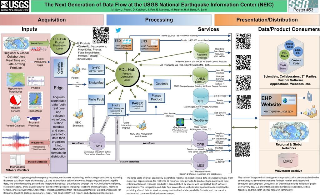
The U.S. Geological Survey (USGS) National Earthquake Information Center (NEIC)
|
|
|
- Mariah Chandler
- 6 years ago
- Views:
Transcription
1 The U.S. Geological Survey (USGS) National Earthquake Information Center (NEIC) Gavin Hayes U.S. Geological Survey, National Earthquake Information Center

2 NEIC Mission
3 NEIC - The People 24x7 Operations 1 Director 1 Supervisory Geophysicist 14 Geophysicists 1 Bulletin Editor Research 6 Ph.D. Geophysicist 4-6 University Researchers 2-3 Summer Interns 3 Contractors Web Development 4 Software Developers Systems Engineering 4 Software Developers 1 Software Engineer Field Operations (GSN and Backbone) 1 Science-in-Charge 1 Director of Operations ~30 Engineers/Admin
4 Post-Earthquake Information Products Mostly made by academic community All In-House

5 Post-Earthquake Information Products
6 NEIC Response Products Response Goal: To release accurate & actionable information regarding an earthquake s location, size, and potential impact, as rapidly as possible.

7 Rapid Moment Tensors - W Phase events published since July Approximately complete above M6. Authoritative NEIC magnitude for M6+ EQs in response, and for PDE.


8 Rapid Moment Tensors - W Phase events published since July Approximately complete above M6. Authoritative NEIC magnitude for M6+ EQs in response, and for PDE.
9 SHAKEMAP USGS s tool to rapidly assess the intensity of shaking - and thus potential damage - caused by an earthquake.
10 DYFI? is a way for community users - YOU! - to contribute to our earthquake response.
11 Answers to these specific questions are very diagnostic of earthquake intensity.


12 Answers to these specific questions are very diagnostic of earthquake intensity.
13 Prompt Assessment of Global Earthquakes for Response The next step is to assess how many people experienced such shaking intensities...

14 USGS PAGER: M 9.0, NEAR THE EAST COAST OF HONSHU, JAPAN Origin Time: Fri :46:23 UTC (14:46:23 local) Location: o N o E Depth: 32 km FOR TSUNAMI INFORMATION, SEE: tsunami.noaa.gov Estimated Fatalities Red alert for shaking-related fatalities and economic losses. High casualties and extensive damage are probable and the disaster is likely widespread. Past red alerts have required a national or international response. Estimated Population Exposed to Earthquake Shaking ESTIMATED POPULATION EXPOSURE (k = x1000) - -* 13,068k* 21,353k* 8,612k* 10,080k* 34,125k* 6,009k* 251k 0 Prompt Assessment of Global ESTIMATED MODIFIED MERCALLI INTENSITY POTENTIAL Earthquakes DAMAGE for Response Population Exposure Compares ShakeMap to population density to calculate how many people were exposed to each level of shaking. PAGER Version 12 Created: 2 weeks, 1 day after earthquake Estimated Economic Losses PERCEIVED SHAKING Not felt Weak Light Moderate Strong Very Strong Severe Violent Extreme Resistant Structures Vulnerable Structures none none none none *Estimated exposure only includes population within the map area. Estimated economic losses are 0-1% GDP of Japan. none none V. Light Light Light Moderate Moderate Moderate/Heavy population per ~1 sq. km from Landscan PAGER content is automatically generated, and only considers losses due to structural damage. Limitations of input data, shaking estimates, and loss models may add uncertainty. Moderate/Heavy Heavy Heavy V. Heavy V. Heavy V. Heavy Structures: Overall, the population in this region resides in structures that are resistant to earthquake shaking, though some vulnerable structures exist. The predominant vulnerable building types are non-ductile reinforced concrete frame and heavy wood frame construction. Historical Earthquakes (with MMI levels): Date Dist. Mag. Max Shaking (UTC) (km) MMI(#) Deaths VII(428k) VII(132k) VII(174k) 104 Recent earthquakes in this area have caused secondary hazards such as tsunamis, landslides, and fires that might have contributed to losses. Selected City Exposure from GeoNames.org MMI City Population IX Furukawa 76k IX Iwanuma 42k IX Hitachi 186k IX Kogota 20k VIII Shiogama 60k VIII Sukagawa 69k VII Tokyo 8,337k VII Yokohama 3,574k IV Nagoya 2,191k III Osaka 2,592k III Kobe 1,528k bold cities appear on map (k = x1000) Event ID: usc0001xgp
15 Prompt Assessment of Global Earthquakes for Response Estimated Fatalities Red alert for shaking-related fatalities and economic losses. High casualties and extensive damage are probable and the disaster is likely widespread. Past red alerts have required a national or international response. Estimated Economic Losses Estimated economic losses are 0-1% GDP of Japan. PAGER uses a color-coded earthquake impact scale, communicating predicted impact and response needed after an event: green (little or no impact), yellow (regional impact and response), orange (nationalscale impact and response), and red (international response).
16 Earthquakes Are Not Points! M9.0, Japan, Slip (m)
17 Earthquakes Are Not Points! M9.0, Japan, M8.8, Chile, Slip (m)
18 Earthquakes Are Not Points! M9.0, M7.6, Japan, Costa Rica, M8.8, Chile, Slip (m)


")

19 Earthquakes Are Not Points! M9.0, M7.6, Japan, Costa Rica, M8.8, Chile, M7.8, Haida Gwaii, Canada, Slip (m)

20 Rupture Models - Why Finiteness Matters Two scenarios shown for 2011 Tohoku earthquake; one with northward rupture, and one to the south. Shaking intensities much higher in Tokyo in southward rupture scenario.
21 Rupture Models - Why Finiteness Matters Thus, population exposures significantly increase for the southward scenario as well.
22 Rupture Models - Why Finiteness Matters Thus, population exposures significantly increase for the southward scenario as well.
23 Communication A response network is only as good as its ability to communicate
24
 - A New Web")
25 ComCat (Combined Catalog) - A New Web Interface
26
27
28
29
30
31
32 2014 Web Statistics

33 Information On The Move


34 Earthquake Notification Service Event pages linked directly from text messages; instant access to all event-based info in new, phone-friendly web format.
35 Changes in Modern EQ Response Rising Expectation from the Public, Media, State and Federal Agencies ~ 1 min after EQ felt in ~ 1AM) - Increasingly the planet is becoming more wired. Citizens get upset if they don t get good information quickly.
36 Changes in Modern EQ Response Rising Expectation from the Public, Media, State and Federal Agencies ~ 1 min after EQ felt in ~ 1AM) - Increasingly the planet is becoming more wired. Citizens get upset if they don t get good information quickly.
37 Changes in Modern EQ Response Rising Expectation from the Public, Media, State and Federal Agencies ~ 1 min after EQ felt in ~ 1AM) - Increasingly the planet is becoming more wired. Citizens get upset if they don t get good information quickly.
38 Changes in Modern EQ Response 03:50: /04/17 Rising Expectation 03:50: /04/17 from the 03:50:46 Public, UL: Chile. Providencia. Media, State and UL: Federal Santiago,Chile Agencies GEO: , ~ 1 min (C) after GEO: EQ , felt in Santiago ~ (C) 1AM) Terremoto!!!!!!!!!!!!!!! Temblor - Increasingly the planet is becoming 2012/04/17 03:50:46 UL: Chile, Santiago GEO: , (C) temblor pesado more wired. Citizens UL: Viña get del upset Mar, Chile. if they don t get good information quickly. 2012/04/17 03:50:46 UL: San Antonio, Chile GEO: , (C) weno el temblor mierda 2012/04/17 03:50:45 GEO: , (C) Temblor 2012/04/17 03:50:34 UL: Kristenland, Chile GEO: , (C) OOOOOOOOH TEMBLOR 2012/04/17 03:50:46 UL: SCL-Santiago de Chile GEO: , (C) temblor!!!! 2012/04/17 03:50:34 UL: Viña del mar, Chile GEO: , (C) Uyyyy temblor fuerte

39 Twitter Twitter Earthquake Dispatch ~50,000 followers Highly scaleable Tweets alerts for M5.5+ EQs

40 Communicating EQ Products - PDL
41 USGS NEIC


42 EQ Notifications The products we serve - magnitude doesn t tell us how an earthquake affects people. New products have allowed us to both improve our rapid response, and serve more useful information.
43 Comparing EQ Response Response 2004 Sumatra EQ (M 9.1) vs 2011 Tohoku EQ (M 9.0) OT + 30 min OT + 75 min OT + 6 hr OT + 7 hr E Q O R I G I N T I M E min 38 min 65 min Public Release M 7.9 Update # 1 Mw 8.8 Update # 2 Mw 8.9 PAGER Red Alert (Economic Loss) min 6 hr 13 min Public Release Ms hrs Finiteness in ShakeMap Update # 1 Mw 8.9 (gcmt) 6 hr 55 min Slip FFF Map Published (One of our last response products)
 USGS NEIC (earthquake.usgs.")
44 Questions? Gavin P. Hayes USGS NEIC (earthquake.usgs.gov) See the detailed earthquake response and educational material, etc., on our website!
88 Hours: The U.S. Geological Survey National Earthquake Information Center Response to the 11 March 2011 M w 9.0 Tohoku Earthquake
 E 88 Hours: The U.S. Geological Survey National Earthquake Information Center Response to the 11 March 211 M w 9. Tohoku Earthquake Gavin P. Hayes, Paul S. Earle, Harley M. Benz, David J. Wald, Richard
2014/TPTWG/WKSP/013 Responding to Global Earthquake Hazards
 2014/TPTWG/WKSP/013 Responding to Global Earthquake Hazards Submitted by: United States Workshop on Improving Global Supply Chain Resilience: Advancing the Seven APEC Principles in Your Organization Christchurch,
Magnitude 7.1 NEAR THE EAST COAST OF HONSHU, JAPAN
 Japan was rattled by a strong aftershock and tsunami warning Thursday night nearly a month after a devastating earthquake and tsunami flattened the northeastern coast. This earthquake can be considered
Handout 1. Amplitude. Time (in s) Amplitude Amplitude. Time (in s) Time (in s) East RUS. North. Vertical. East WLT. North. Vertical KIK. East.
 Amplitude Amplitude. Time (in s) Time (in s) East RUS. North. Vertical. East WLT. North. Vertical KIK. East.") Handout 1 East RUS Amplitude Amplitude Amplitude North Vertical East North Vertical East North Time (in s) Time (in s) WLT KIK Vertical Time (in s) Handout 2 34 30' 34 24' 34 18' 34 12' KIK 34 06' MON
Handout 1 East RUS Amplitude Amplitude Amplitude North Vertical East North Vertical East North Time (in s) Time (in s) WLT KIK Vertical Time (in s) Handout 2 34 30' 34 24' 34 18' 34 12' KIK 34 06' MON
Overview. Tools of the Trade. USGS Decision-Making Tools for Pre-Earthquake Mitigation and Post-Earthquake Response
 USGS Decision-Making Tools for Pre-Earthquake Mitigation and Post-Earthquake Response Tools of the Trade DAVID WALD United States Geological Survey NEHRP Workshop: Developing Earthquake Scenarios Sept
ShakeAlert Earthquake Early Warning
 ShakeAlert Earthquake Early Warning Doug Given USGS, Pasadena Earthquake Program, Early Warning Coordinator 10 seconds 50 seconds 90 seconds USGS Earthquake Hazard Responsibilities USGS has the lead federal
Magnitude 7.0 NEW CALEDONIA
 A magnitude 7.0 earthquake has occurred 82km ENE of Maré Island, the secondlargest of the Loyalty Islands in the archipelago of New Caledonia. The initial report of the magnitude and shallow 10km depth
Magnitude 8.2 FIJI. A magnitude 8.2 earthquake occurred km (226.7 mi) E of Suva, Fiji at a depth of km (350 miles).
 E of Suva, Fiji at a depth of km (350 miles).") A magnitude 8.2 earthquake occurred 364.8 km (226.7 mi) E of Suva, Fiji at a depth of 563.4 km (350 miles). There is no risk of a tsunami from an earthquake at this depth. Images courtesy of Google The
A magnitude 8.2 earthquake occurred 364.8 km (226.7 mi) E of Suva, Fiji at a depth of 563.4 km (350 miles). There is no risk of a tsunami from an earthquake at this depth. Images courtesy of Google The
Magnitude 6.9 GULF OF CALIFORNIA
 A pair of strong earthquakes struck off the coast of Mexico early Thursday only minutes apart. The magnitude 6.9 and 6.2 were centered about 85 miles northeast of Guerrero Negro in the Mexican state of
Magnitude 7.2 OAXACA, MEXICO
 A magnitude 7.2 earthquake has occurred in Oaxaca, Mexico at a depth of 24.6 km (15 miles). It was felt as far away as Guatemala. There have been no reported deaths directly linked to the earthquake. Emergency
Magnitude 7.7 QUEEN CHARLOTTE ISLANDS REGION
 A major 7.7 magnitude earthquake struck at 8:04 PM local time in western British Columbia, Canada. The epicenter is located on Moresby Island, the southern large island in the Queen Charlotte Islands region.
Citizen Science at the. U.S. Geological Survey
 Citizen Science at the U.S. Geological Survey David Applegate USGS Associate Director for Natural Hazards NRC Board on Earth Science & Resources December 5, 2014 U.S. Department of the Interior U.S. Geological
Magnitude 7.3 OFFSHORE EL SALVADOR
 A magnitude 7.3 earthquake struck off the Pacific coast of Central America late Monday night, early reports indicate one death. The earthquake occurred at a depth of 40 km (24.9 miles). Its epicenter was
RAPID EXPOSURE AND LOSS ESTIMATES FOR THE MAY 12, 2008 Mw 7.9 WENCHUAN EARTHQUAKE PROVIDED BY THE U.S. GEOLOGICAL SURVEY S PAGER SYSTEM
 RAPID EXPOSURE AND LOSS ESTIMATES FOR THE MAY 12, 2008 Mw 7.9 WENCHUAN EARTHQUAKE PROVIDED BY THE U.S. GEOLOGICAL SURVEY S PAGER SYSTEM ABSTRACT : P.S. Earle 1, D.J. Wald 1, T.I. Allen 1, K.S. Jaiswal
Magnitude 7.9 SE of KODIAK, ALASKA
 A magnitude 7.9 earthquake occurred at 12:31 am local time 181 miles southeast of Kodiak at a depth of 25 km (15.5 miles). There are no immediate reports of damage or fatalities. Light shaking from this
Magnitude 7.0 N of ANCHORAGE, ALASKA
 A magnitude 7.0 earthquake occurred just before 8:30 am local time 8 miles north of Anchorage at a depth of 40.9 km (25.4 miles). There are reports of major infrastructure damage and damage to many homes
Magnitude 7.1 PERU. There are early reports of homes and roads collapsed leaving one dead and several dozen injured.
 A magnitude 7.1 earthquake has occurred offshore Peru. The earthquake struck just after 4 a.m. local time and was centered near the coast of Peru, 40 km (25 miles) south-southwest of Acari, Peru at a depth
Agency Vision and Decision- Maker Needs: A USGS Perspective
 Agency Vision and Decision- Maker Needs: A USGS Perspective Connecting Grassroots to Government for Disaster Management David Applegate USGS Associate Director for Natural Hazards September 13, 2012 U.S.
Magnitude 7.6 SOUTH OF IQUIQUE, CHILE
 A powerful aftershock struck off northern Chile prompting an evacuation of the coastal area and raising fears of a tsunami. This magnitude 7.6 earthquake is the largest of a series of aftershocks following
Magnitude 7.0 PAPUA, INDONESIA
 A 7.0 magnitude earthquake struck eastern Indonesia's mountainous West Papua province on Saturday but there were no immediate reports of casualties or damage. The region is sparsely populated. According
Magnitude 8.3 SEA OF OKHOTSK
 A powerful earthquake in Russia's Far East was felt as far away as Moscow, about 7,000 kilometers (4,400 miles) west of the epicenter, but no casualties or damage were reported. The epicenter was in the
M-8.1 EARTHQUAKE 87KM SW OF PIJIJIAPAN, MEXICO EXACT LOCATION: N W DEPTH: 69.7KM SEPTEMBER 7, 11:49 PST
 M-8.1 EARTHQUAKE 87KM SW OF PIJIJIAPAN, MEXICO EXACT LOCATION: 15.068 N 93.715 W DEPTH: 69.7KM SEPTEMBER 7, 2017 @ 11:49 PST Photo: Luis Alberto Cruz / AP Photo: Carlos Jasso 1 THE 2017 CHIAPAS MEXICO
How to communicate Cascadia Subduction Zone earthquake hazards
 How to communicate Cascadia Subduction Zone earthquake hazards Tom Brocher Research Geophysicist Earthquake Science Center U.S. Geological Survey Menlo Park, California Seattle Post-Intelligencer Lessons
Magnitude 7.1 PHILIPPINES
 A magnitude 7.1 earthquake struck in the southeastern Philippines just after 8 am local time Tuesday morning killing 82 people and reducing a 17 th century church to rubble. Offices and schools were closed
Three Fs of earthquakes: forces, faults, and friction. Slow accumulation and rapid release of elastic energy.
 Earthquake Machine Stick-slip: Elastic Rebound Theory Jerky motions on faults produce EQs Three Fs of earthquakes: forces, faults, and friction. Slow accumulation and rapid release of elastic energy. Three
Tsunami waves swept away houses and cars in northern Japan and pushed ships aground.
 Japan was struck by a magnitude 8.9 earthquake off its northeastern coast Friday. This is one of the largest earthquakes that Japan has ever experienced. In downtown Tokyo, large buildings shook violently
Mw 7.8, Southwest of Sumatra, Indonesia Wed, 2 March 2016 at 12:49:48 UTC M /03/03
 Earthquake overview AFGHANISTA N PAKISTA N INDIA A moment magnitude (Mw) 7.8 earthquake struck in South West, Indonesia. The epicentre was centered about 800 km West South West of Padang, Sumatra province,
Magnitude 7.6 HONDURAS
 A magnitude 7.6 earthquake has occurred in the Caribbean between Honduras and the Cayman Islands approximately 125 miles (202 km) north-northeast of Barra Patuca, Honduras, and 188 miles (303 km) southwest
Magnitude 7.5 PALU, INDONESIA
 A magnitude 7.5 earthquake occurred 80.8 km (50.2 mi) north of Palu, Indonesia at a depth of 10 km (6.2 miles). This earthquake triggered a tsunami with wave heights up to 2 m (6.6 ft) that an official
Magnitude 7.6 & 7.4 SOLOMON ISLANDS
 A magnitude 7.6 earthquake struck near the Solomon Islands on Sunday morning local time; there were no immediate reports of damage. The earthquake was centered 100 km (60 miles) south of Kira Kira, a town
Magnitude 8.2 NORTHWEST OF IQUIQUE, CHILE
 An 8.2-magnitude earthquake struck off the coast of northern Chile, generating a local tsunami. The USGS reported the earthquake was centered 95 km (59 miles) northwest of Iquique at a depth of 20.1km
Magnitude 7.0 PERU. This region of the Andes is a sparsely populated area, there were no immediate reports of injuries or damage.
 A magnitude 7.0 earthquake occurred in southeastern Peru on Friday about 27 kilometers northeast of the town of Azángaro, Peru, near the border with Bolivia. The earthquake occurred at a depth of 257.4
A magnitude 7.8 earthquake has occurred km (63.3 mi) ESE of Suva, Fiji at a depth of km (378 miles).
 ESE of Suva, Fiji at a depth of km (378 miles).") A magnitude 7.8 earthquake has occurred 101.8 km (63.3 mi) ESE of Suva, Fiji at a depth of 608.6 km (378 miles). There is no risk of a tsunami from an earthquake at this depth. Images courtesy of Google
A magnitude 7.8 earthquake has occurred 101.8 km (63.3 mi) ESE of Suva, Fiji at a depth of 608.6 km (378 miles). There is no risk of a tsunami from an earthquake at this depth. Images courtesy of Google
Magnitude 7.3 IRAQ. Early reports indicate that 140 have been killed with over 800 injuries reported. Sunday, November 12, 2017 at 18:18:17 UTC
 A magnitude 7.3 earthquake has occurred in the northern border region of Iran and Iraq centered about 350 kilometers (217 miles) north of Baghdad at a depth of 33.9 km (21 miles). The earthquake was felt
Magnitude 7.1 SOUTH SANDWICH ISLANDS
 A magnitude 7.1 earthquake occurred at a depth of 164.7 km (102 miles) in the South Sandwich Islands, an uninhabited British territory off the coast of Argentina in the southern Atlantic Ocean. Antarctica
Magnitude 7.8 SCOTIA SEA
 A magnitude 7.8 earthquake has occurred in the South Orkney Island region in the Scotia Sea. According to the USGS, this earthquake is the latest in a series of moderate-tolarge earthquakes to strike this
Lessons Learned from Past Tsunamis Warning and Emergency Response
 UNESCO IOC CTIC US NOAA ITIC Regional Training Workshop on Strengthening Tsunami Warning and Emergency Response Standard Operating Procedures and the Development of the ICG/CARIBE-EWS PTWC New Enhanced
Magnitude 7.5 PAPUA NEW GUINEA
 A magnitude 7.5 earthquake occurred 33 kilometers (20 miles) southwest of Tari, Papua New Guinea, at a depth of 35 km (22 miles). Papua New Guinea is located on the eastern half of the island of New Guinea,
Magnitude 7.5 NEW BRITAIN REGION, PAPUA NEW GUINEA
 A magnitude 7.5 earthquake struck off the eastern coast of Papua New Guinea on Sunday, approximately 54 km (33 miles) southeast of Kokopo. Residents reported strong ground shaking for about five minutes.
Magnitude 7.0 VANUATU
 A major earthquake struck in the southwest Pacific Ocean at a depth of 27 km beneath the island of Melampa in the Vanuatu island chain. There are no reports of damage. The Modified Mercalli Intensity (MMI)
Magnitude 7.3 NEPAL. Tuesday, May 12, 2015 at 07:05:19 UTC
 A magnitude 7.3 earthquake has occurred near Mount Everest. Early reports suggest 32 people have been killed and at least 1,000 were injured in the earthquake. The region is still in recovery from a 7.8
Magnitude 7.5 NEW BRITAIN REGION, PAPUA NEW GUINEA
 A magnitude 7.5 earthquake struck off the eastern coast of Papua New Guinea on Tuesday, approximately 130 km (81 mi) southsouthwest of Kokopo at a depth of 42 km (26.1 mi). There are reports of some structural
NATURAL HAZARDS MISSION AREA SAFRR Project: Science Applica>on for Risk Reduc>on
 NATURAL HAZARDS MISSION AREA SAFRR Project: Science Applica>on for Risk Reduc>on The Scenario 1 Natural Hazards: Earthquake Volcanic Erup>on Landslide Flood Geomagne>c Storm Wildfire Tsunami Coastal Erosion
M 7.1 EARTHQUAKE 5KM ENE OF RABOSO, MEXICO EXACT LOCATION: N W DEPTH: 51.0KM SEPTEMBER 19, 1:14 LOCAL TIME
 M 7.1 EARTHQUAKE 5KM ENE OF RABOSO, MEXICO EXACT LOCATION: 18.584 N 98.399 W DEPTH: 51.0KM SEPTEMBER 19, 2017 @ 1:14 LOCAL TIME Photo: Eduardo Verdugo / AP Photo: Alfredo Estrella/ Agence France-Presse/
Current Landscape of Spatial Decision Support Systems (SDSS) and Software Applications for Earthquake Disaster Management in Turkey
 and Software Applications for Earthquake Disaster Management in Turkey") Presented at the FIG Congress 2018, May 6-11, 2018 in Istanbul, Turkey Current Landscape of Spatial Decision Support Systems (SDSS) and Software Applications for Earthquake Disaster Management in Turkey
Presented at the FIG Congress 2018, May 6-11, 2018 in Istanbul, Turkey Current Landscape of Spatial Decision Support Systems (SDSS) and Software Applications for Earthquake Disaster Management in Turkey
Initiative. Country Risk Profile: papua new guinea. Better Risk Information for Smarter Investments PAPUA NEW GUINEA.
 Pacific Catastrophe Risk Assessment And Financing Initiative PAPUA NEW GUINEA September 211 Country Risk Profile: papua new is expected to incur, on average, 85 million USD per year in losses due to earthquakes
Magnitude 7.4 SOUTH GEORGIA ISLAND REGION
 A magnitude 7.4 earthquake occurred in the South Georgia Island Region. South Georgia Island is a British territory in the South Atlantic Ocean that lies about 800 miles east of the Falkland Islands. It
Magnitude 6.3 SOUTH ISLAND OF NEW ZEALAND
 A magnitude 6.3 earthquake shook the southern New Zealand city of Christchurch. At least 100 people are reported dead, and there are reports of collapsed buildings, cracked streets and flooding due to
Advantages of Regional and Global Data Exchange. Gavin Hayes U.S. Geological Survey, National Earthquake Information Center
 Advantages of Regional and Global Data Exchange Gavin Hayes U.S. Geological Survey, National Earthquake Information Center USGS NEIC Global Earthquake Response Area of responsibility => Global BUT - domestically,
New Madrid and Central U.S. Region Earthquake Hazard
 New Madrid and Central U.S. Region Earthquake Hazard Rob Williams U.S. Geological Survey, Golden, CO March 16, 2017 Reelfoot Lake, TN U.S. Department of the Interior U.S. Geological Survey 1811-12 New
Pacific Catastrophe Risk Assessment And Financing Initiative
 Pacific Catastrophe Risk Assessment And Financing Initiative TUVALU is expected to incur, on average,. million USD per year in losses due to earthquakes and tropical cyclones. In the next 5 years, has
M-6.2 EARTHQUAKE NORCIA, ITALY AUGUST 24, 01:36:33 UTC
 M-6.2 EARTHQUAKE NORCIA, ITALY AUGUST 24, 2016 @ 01:36:33 UTC EARTHQUAKE REPORT - NORCIA, ITALY M-6.2, 24 August 2016 The M-6.2 earthquake had a shallow depth (10 km) and struck approximately 10 km SE
Released Science Inquiry Task Location Grade 11
 Date: Your Name: Released Science Inquiry Task Location 2009 Grade 11 Science Directions: You will be completing an extended-response inquiry task called Location. Explain the reasons for all of your answers.
Pacific Catastrophe Risk Assessment And Financing Initiative
 Pacific Catastrophe Risk Assessment And Financing Initiative TIMOR-LESTE September Timor-Leste is expected to incur, on average, 5.9 million USD per year in losses due to earthquakes and tropical cyclones.
7.1 FIJI 1, :57:22 UTC
 A magnitude 7.1 earthquake struck 141 km (88 miles) northeast of Ndoi Island, Fiji, and 313 km (194 mi) west-northwest of Nuku alofa, Tonga according to the US Geological Survey, but there were no reports
Tsunami and earthquake in Chile Part 2
 EUROPEAN COMMISSION DIRECTORATE GENERAL JRC JOINT RESEARCH CENTRE Institute for the Protection and Security of the Citizen Global Security and Crisis Management Unit CriTech Sunday, 28 February 2010 Executive
Hazard and Vulnerability of Moderate Seismicity Regions
 Hazard and Vulnerability of Moderate Seismicity Regions presented by Professor Tso-Chien PAN Dean, College of Engineering Director, 25 October 2010 DRM GDLN Session on Earthquake Vulnerability Reduction
Module 2, Investigation 1: Earthquake Hazards
 Module 2, Investigation 1: Earthquake Hazards Introduction Welcome! In the last module, you assumed the role of a volcanologist and learned how volcanoes are described and monitored. You will now assume
EARTHQUAKE MODELLING. Algiers, Belhassen Tonat
 EARTHQUAKE MODELLING Algiers, 10.11.2011 Belhassen Tonat Basic terms Plate tectonics Basic terms Average Number of Earthquakes/Year (Global) Magnitude Average Annually 8 and higher 1 ¹ 7-7.9 17 ² 6-6.9
Pacific Catastrophe Risk Assessment And Financing Initiative
 Pacific Catastrophe Risk Assessment And Financing Initiative PALAU September is expected to incur, on average,.7 million USD per year in losses due to earthquakes and tropical cyclones. In the next 5 years,
Two Contrasting InSAR Studies of Recent Earthquakes in Tibet
 Two Contrasting InSAR Studies of Recent Earthquakes in Tibet Barry Parsons Department of Earth Sciences University of Oxford John Elliott, Wanpeng Feng,, James Jackson, Zhenhong Li, Xinjian Shan, Alastair
Magnitude 6.3, NORTH OF MOROCCO
 Earthquake location & overview A magnitude 6.3 earthquake struck in Alboran Sea, orth of Morocco; the epicentre was centered about 54 km ( 34 miles) E of Al Hoceima. The depth has been estimated to be
Magnitude 7.6 & 7.6 PERU
 Two deep 7.6 magnitude earthquakes have shaken a sparsely populated jungle region near the Peru-Brazil border in southeast Peru. There were no immediate reports of injuries or damage. The second M 7.6
Earthquakes.
 Earthquakes http://thismodernworld.com/comic-archive Elastic rebound http://projects.crustal.ucsb.edu/understanding/elastic/rebound.html Elastic rebound Rocks store energy elastically When stored stress
The IISEE earthquake catalog, Catalog of Damaging Earthquakes in the World, IISEE-NET,, and BRI strong motion observation
 The IISEE earthquake catalog, Catalog of Damaging Earthquakes in the World, IISEE-NET,, and BRI strong motion observation Tatsuhiko Hara International Institute of Seismology and Earthquake Engineering,
Lessons from the 2004 Sumatra earthquake and the Asian tsunami
 Lessons from the 2004 Sumatra earthquake and the Asian tsunami Kenji Satake National Institute of Advanced Industrial Science and Technology Outline 1. The largest earthquake in the last 40 years 2. Tsunami
Pacific Catastrophe Risk Assessment And Financing Initiative
 Pacific Catastrophe Risk Assessment And Financing Initiative VANUATU September 211 Country Risk Profile: VANUATU is expected to incur, on average, 48 million USD per year in losses due to earthquakes and
JCR (2 ), JGR- (1 ) (4 ) 11, EPSL GRL BSSA
, JGR- (1 ) (4 ) 11, EPSL GRL BSSA") Dun Wang ( ) In collaboration with: Hitoshi Kawakatsu, Jim Mori, Kazuki Koketsu, Takuto Maeda, Hiroshi Tsuroka, Jiancang Zhunag, Lihua Fang, and Qiang Yao School of Geosciences, China University of Geosciences
Dun Wang ( ) In collaboration with: Hitoshi Kawakatsu, Jim Mori, Kazuki Koketsu, Takuto Maeda, Hiroshi Tsuroka, Jiancang Zhunag, Lihua Fang, and Qiang Yao School of Geosciences, China University of Geosciences
Tsunami Response and the Enhance PTWC Alerts
 Tsunami Response and the Enhance PTWC Alerts Ken Gledhill GeoNet Project Director Chair, Intergovernmental Coordination Group, Pacific Tsunami Warning and Mitigation System (PTWS) Overview 1. Procedures
Earthquake Source. Kazuki Koketsu. Special Session: Great East Japan (Tohoku) Earthquake. Earthquake Research Institute, University of Tokyo
 Earthquake. Earthquake Research Institute, University of Tokyo") 2012/9/24 17:20-17:35 WCEE SS24.4 Special Session: Great East Japan (Tohoku) Earthquake Earthquake Source Kazuki Koketsu Earthquake Research Institute, University of Tokyo 1 Names and features of the earthquake
2012/9/24 17:20-17:35 WCEE SS24.4 Special Session: Great East Japan (Tohoku) Earthquake Earthquake Source Kazuki Koketsu Earthquake Research Institute, University of Tokyo 1 Names and features of the earthquake
Establishment and Operation of a Regional Tsunami Warning Centre
 Establishment and Operation of a Regional Tsunami Warning Centre Dr. Charles McCreery, Director NOAA Richard H. Hagemeyer Pacific Tsunami Warning Center Ewa Beach, Hawaii USA Why A Regional Tsunami Warning
The Application of Global Scale Data in a Global Earthquake Disaster Alert System
 The Application of Global Scale Data in a Global Earthquake Disaster Alert System LI Yigang 1 QU Guosheng 1 HUANG Jianfa 2 1,National Earthquake Response Support Service,China 2,China Earthquake Administration,China
DETERMINATION OF EARTHQUAKE PARAMETERS USING SINGLE STATION BROADBAND DATA IN SRI LANKA
 DETERMINATION OF EARTHQUAKE PARAMETERS USING SINGLE STATION BROADBAND DATA IN SRI LANKA S.W.M. SENEVIRATNE* MEE71 Supervisors: Yasuhiro YOSHIDA** Tatsuhiko HARA*** ABSTRACT We determined epicenters and
Tsunami early warning based on surface wave inversion techniques
 Tsunami early warning based on surface wave inversion techniques H.K. Thio URS Corporation, Los Angeles, CA, USA J. Polet California State Polytechnic University, Pomona CA, USA SUMMARY: We studied a method
Baldwin County, Alabama
 2015 Baldwin County, Alabama Multi-Hazard Mitigation Plan I. Comprehensive Plan A multi-jurisdiction plan City of Bay Minette City of Daphne Town of Elberta City of Fairhope City of Foley City of Gulf
FOURTH GRADE HAZARDS 1 WEEK LESSON PLANS AND ACTIVITIES
 FOURTH GRADE HAZARDS 1 WEEK LESSON PLANS AND ACTIVITIES PLATE TECTONIC CYCLE OVERVIEW OF FOURTH GRADE VOLCANOES WEEK 1. PRE: Comparing different structures of volcanoes. LAB: Modeling three types of volcanoes.
Deterministic and Non-deterministic Behavior of Earthquakes and Hazard Mitigation Strategy
 Deterministic and Non-deterministic Behavior of Earthquakes and Hazard Mitigation Strategy Hiroo Kanamori Seismological Laboratory, California Institute of Technology Earthquake Process Deterministic Non-deterministic
The Inevitability and Consequences of Mega-Disasters in a Crowded World
 The Inevitability and Consequences of Mega-Disasters in a Crowded World John J. Clague Centre for Natural Hazard Research Simon Fraser University NOAA Katrina 2005 Outline Hazard, risk, disasters, and
Natural Disasters Spring, LECTURE #8: Earthquake Disasters: Monitoring & Mitigation. Date: 1 Feb 2018 (lecturer: Dr.
 GEOL 0820 Ramsey Natural Disasters Spring, 2018 LECTURE #8: Earthquake Disasters: Monitoring & Mitigation Date: 1 Feb 2018 (lecturer: Dr. Shawn Wright) I. Exam I - Reminder Feb 6 th next class details:
The Mega-Earthquakes of Chile: Seismology and the Sounds of the Earth
 The Mega-Earthquakes of Chile: Seismology and the Sounds of the Earth Michael Wysession Department of Earth and Planetary Sciences Washington University, St. Louis, MO Puerto Montt, Chile, November 6,
Measuring EQ, Tsunamis
 16 June 16 Summer Session 2016 Horst Rademacher HH Lect 6: Earth s Interior Measuring EQ, Tsunamis http://seismo.berkeley.edu/~horst/summer2016.html Recap from Midterm Questions 4: Question 8: Question
SEISMIC RISK ASSESSMENT IN ARMENIA
 SEISMIC RISK ASSESSMENT IN ARMENIA Hovhannes Khangeldyan Head of National Crisis Management Center Rescue Service Ministry of Emergency Situations of the Republic of Armenia Tokyo, 2016 ARMENIA: GEOGRAPHICAL
ShakeAlert Phase 1: West Coast Earthquake Early Warning. Doug Given, USGS EEW Coordinator Education Symposium, Dec. 4, 2018
 ShakeAlert Phase 1: West Coast Earthquake Early Warning Doug Given, USGS EEW Coordinator Education Symposium, Dec. 4, 2018 Population WA 7M OR 4M Annualized Earthquake Losses, $6.1B 61% in California,
Advanced Workshop on Evaluating, Monitoring and Communicating Volcanic and Seismic Hazards in East Africa.
 2053-13 Advanced Workshop on Evaluating, Monitoring and Communicating Volcanic and Seismic Hazards in East Africa 17-28 August 2009 Hazard Communication: Examples From Tanzania, Mozambique, and Cameroon
Earthquakes down under: a rare but real hazard
 University of Wollongong Research Online Faculty of Science, Medicine and Health - Papers Faculty of Science, Medicine and Health 2015 Earthquakes down under: a rare but real hazard Solomon Buckman University
The challenge of risk communication how risk communication is the key to triggering action: Experiences from the Philippines and PNG
 The challenge of risk communication how risk communication is the key to triggering action: Experiences from the Philippines and PNG Dr Andrew Jones on behalf of the Regional Development Group and partners
3D Seismic Hazard and Risk Maps for Earthquake Awareness of Citizens with Aids of GIS and Remote Sensing Technologies
 3D Seismic Hazard and Risk Maps for Earthquake Awareness of Citizens with Aids of GIS and Remote Sensing Technologies Saburoh Midorikawa Tokyo Institute of Technology In Japan, seismic hazard and risk
Characteristics and introduction of Earthquake in Asia-Pacific region
 Characteristics and introduction of Earthquake in Asia-Pacific region 1906 San Francisco 2011 Tohoku 1999 Chi-Chi 1985 Mexico City 2004 Sumatra Chung-Han Chan 詹忠翰 2011 Christchurch To understand the characteristics
The Magnitude 7.2 Earthquake from the West Valley Fault: Implications for Metro Manila and Nearby Provinces
 The Magnitude 7.2 Earthquake from the West Valley Fault: Implications for Metro Manila and Nearby Provinces First DRI Collegiate Conference in the Philippines 16 March 2017 Renato U. Solidum, Jr. Department
KNOWLEDGE NOTE 5-1. Risk Assessment and Hazard Mapping. CLUSTER 5: Hazard and Risk Information and Decision Making. Public Disclosure Authorized
 Public Disclosure Authorized Public Disclosure Authorized Public Disclosure Authorized Public Disclosure Authorized KNOWLEDGE NOTE 5-1 CLUSTER 5: Hazard and Risk Information and Decision Making Risk Assessment
Seismic Recording Station TA_109C Summary Report
 Seismic Recording Station TA_109C Summary Report Thank you for hosting station TA_109C on your property. We hope that you find the enclosed report interesting. Your station is one of the 2000 USArray seismic
Mondo Quake in Pacific Northwest? By Leander Kahney
 Introduction to College Reading D Natural Disasters: Earthquake NAME I. Pre-reading. Discuss the following topics with other students at your table. What countries or regions of the world have earthquakes?
Cyber Enabled Earth Exploration (CE )
") Cyber Enabled Earth Exploration 3 (CE ) Field Notebook Module 2: Introduction to Earthquakes Investigation 1: Earthquake Hazards Table of Contents Folder 1: Describing Earthquakes... 3 Folder 2: Shaanxi,
Cyber Enabled Earth Exploration 3 (CE ) Field Notebook Module 2: Introduction to Earthquakes Investigation 1: Earthquake Hazards Table of Contents Folder 1: Describing Earthquakes... 3 Folder 2: Shaanxi,
Building earthquake early warning for the west coast. Ken Creager Professor of Earth and Space Sciences University of Washington
 Building earthquake early warning for the west coast Ken Creager Professor of Earth and Space Sciences University of Washington How Earthquake Early Warning works: P-waves S-waves 3-fold way of Earthquake
Earthquakes and Tsunamis
 Earthquakes and Tsunamis Kenji Satake Earthquake Research Institute University of Tokyo 1 Part I 2011 Tohoku earthquake and tsunami 2 Fukushima Dai ichi NPP accident Earthquake ground motion Reactors automatically
HAZUS-MH: Earthquake Event Report
 HAZUS-MH: Earthquake Event Report Region Name: El Paso County Earthquake Scenario: El Paso County Random EQ Print Date: February 08, 2006 Disclaimer: The estimates of social and economic impacts contained
Earthquakes in Canada
 Earthquakes in Canada Maurice Lamontagne, Ph.D., ing. Geological Survey of Canada Natural Resources Canada 1 What is an Earthquake? P S P S P PS 2 2 Movement on a fault plane causes vibrations The larger
The Size of an Earthquake. Intensity of Shaking (Robert Mallet, 1857) Calculation of Earthquake Magnitude (Charles Richter, 1935)
 Calculation of Earthquake Magnitude (Charles Richter, 1935)") The Size of an Earthquake Intensity of Shaking (Robert Mallet, 1857) Calculation of Earthquake Magnitude (Charles Richter, 1935) In 1857, Robert Mallet produced isoseismal lines based on quantified damage
The Size of an Earthquake Intensity of Shaking (Robert Mallet, 1857) Calculation of Earthquake Magnitude (Charles Richter, 1935) In 1857, Robert Mallet produced isoseismal lines based on quantified damage
Seismic Recording Station AZ_PFO Summary Report
 Seismic Recording Station AZ_PFO Summary Report Thank you for hosting station AZ_PFO on your property. We hope that you find the enclosed report interesting. Your station is one of the 2000 USArray seismic
Understanding China Census Data with GIS By Shuming Bao and Susan Haynie China Data Center, University of Michigan
 Understanding China Census Data with GIS By Shuming Bao and Susan Haynie China Data Center, University of Michigan The Census data for China provides comprehensive demographic and business information