The Application of Global Scale Data in a Global Earthquake Disaster Alert System
|
|
|
- Anissa Spencer
- 5 years ago
- Views:
Transcription
1 The Application of Global Scale Data in a Global Earthquake Disaster Alert System LI Yigang 1 QU Guosheng 1 HUANG Jianfa 2 1,National Earthquake Response Support Service,China 2,China Earthquake Administration,China Liyig@263,net
2 Contents 1.Backgroud 2.What is GEDAS 3.Data used by GEDAS 4.Application Samples 5.Future work
3 Background


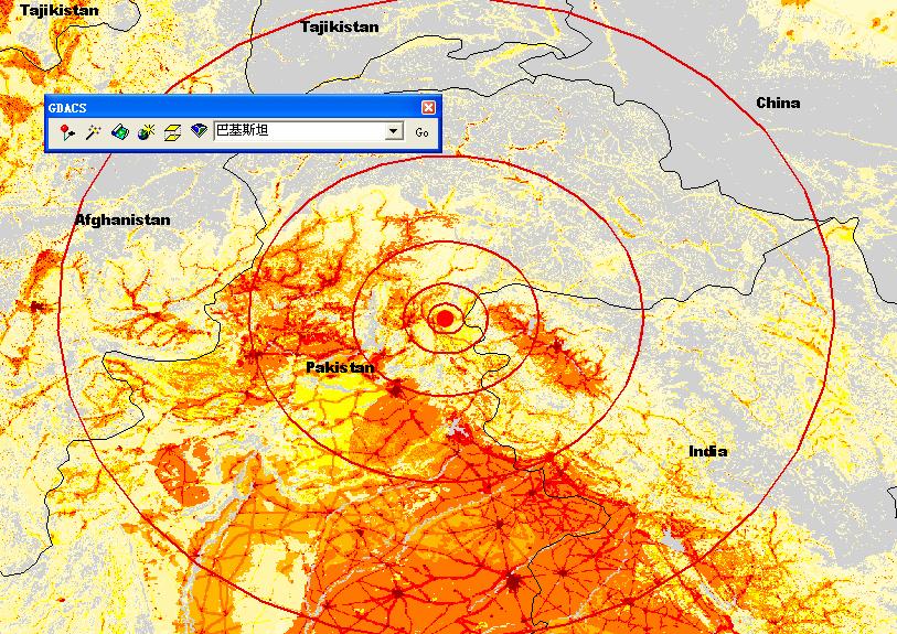
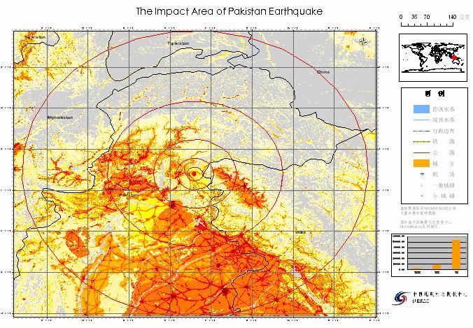
4 Earthquake Disaster Earthquake and earthquake induced disasters, such as the Indian Ocean tsunami in 2004 and the heavily damaged South Asia earthquake in 2005, caused huge economic loss and casualties. Earthquake disasters are becoming the mainly part of catastrophes recently. The Great South Asia Earthquake,2005


 and PAGER (Prompt Assessment of Global Earthquakes for Response) are such alert systems")
5 Need of Earthquake Disaster Alert Although earthquake can not be predicted exactly until now, we can get the magnitude and location for a certain earthquake event quickly after it happened based on the earthquake monitoring network. An earthquake disaster alert system can give a quick estimation of the probable impact and trigger a reasonable emergency response based on the earthquake information and local data and quick response for a disaster event can effectively reduce casualty and economic loss. GDAS(Global Disaster Alert System) and PAGER (Prompt Assessment of Global Earthquakes for Response) are such alert systems (Martin,2004,2005;USGS,2005). GDAS already gave alert assessment and rich local information to ECHO and UN since 2003 yet PAGER is still in construction.


6 Need of CISAR CISAR (China International Search and Rescue Team), an international disaster aid team, was established in CISAR took part in the Algeria, Iran and Pakistan earthquake rescue deployments after it was established. From the three deployments, an information support and alert software system is found to be important for quick and effective rescue. CISAR in Pakistan, 2005
7 What is GEDAS
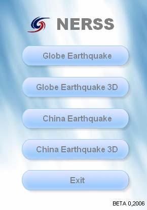
8 The Framework of GEDAS GEDAS composes of three parts, the information acquiring sub-system, the loss estimation sub-system and the information releasing sub-system. Earthquake information can be got directly from monitoring stations and NEIC S global earthquake list service (Finger). The information processing and loss estimation sub-system is the core of GEDAS. Based on the global database and estimation models, GEDAS can give a quick economic loss and casualties estimation and also maps around the epicenter. Earthquake Observations GEDAS Software CISAR& CEA Earthquake Info. Disaster Loss Estimation Map Service, News service Data, Models Alert ( SMS)
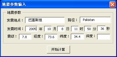
9 The GEDAS Software The GEDAS software is developed on ArcGIS platform. Following figure is the sketch of the modules and the workflow. The software modules include parameters input module, loss estimation and alert assessment module, alert report creating module, alert releasing module and map making module. NEIC Earthquake List Database(VMAP,Landscan,etc.) Earthquake information acquiring module Core Models (Economic loss estimation, casualty estimation, Alert assessment) Parameters Input Module Alert Report Creating Module Earthquake Site Map Making Module Alert releasing Module

10 Disaster estimation and alert assessment model When we compute the economic loss and casualties, we must know at least a rough intensity for a certain region. We use an empirical relationship to estimate the scenario intensity for an earthquake event in GEDAS. Following is the empirical formula we use in GEDAS which derived from the empirical formula used in Western USA (Anderson, 1978; Howell, 1975; Gupta, 1976; Liu Jie, 1999; Gutenberg, 1956). I = I r - 2.7lgr M =2/3 * I I 0 is the intensity in the epicenter,m is the Richter Magnitude,r is the radius,i is intensity for a certain distance from the epicenter
11 Disaster estimation and alert assessment model Referring to the GDAS alert model, we adopt following alert grade assessment formula: A = max(m - 4.5,0) 0.5 * log(max(p / 80000,0)) * max(v,0.5) 1.5 / 3 A is the alert score, M is the magnitude, P is the total population in the area where intensity is lager than six, V is the venerability index and can be got from the ECHO global need assessment report every year. The alert rank can be divided into three kinds, green, yellow and red. When the score value is smaller than 1, green alert will be released; when the score value is between 1 and 2, yellow alert will be released; when the score value is lager than 2, red alert will be released. The international relief organization should concern and prepare for deployment when the red alert is released.
12 Disaster estimation and alert assessment model We use a method that estimate earthquake losses based on several macroeconomic indices such as the Gross Domestic Product (GDP) and population (Chen Yong, 1995; Chen QF, 1999). This method does not require a detailed inventory database of the structures and facilities in the impact region and can get quick loss estimation. The right figure give us the relationship between intensity and the ratio of economic loss by GDP for Low, middle and high income countries separately. Based on this relationship, we can get the economic loss by using following formula: EP is the economic loss, f(i i, GDP)is the ratio of intensity I by GDP, I I is earthquake intensity, GDP is Gross Domestic Product. P T(I i)is the risk of impact of intensity in T years. For a certain earthquake, P T(I i)is always 1.
13 Disaster estimation and alert assessment model Compare to economic loss estimation, casualties estimation is more difficult. A reasonable relationship between earthquake intensity and casualties must think about the structure characters. Because we have not a detail structure database until now, a simple relationship for casualty estimation is used in GEDAS. Intensity Loss Mortality Injury rate VI 0.2 * * 10-4 VII 3.2 * * 10-4 VIII 4.0 * * 10-4 IX 480 * * 10-4
14 Data used by GEDAS
 for each country, calculates a probability coefficient for each cell, and applies the coefficients to the census counts which are employed as control totals for appropriate areas")
15 The Population Data Oak Ridge National Laboratory (ORNL)'s Global Population Project, part of a larger global database effort called LandScan, collects best available census counts (usually at province level) for each country, calculates a probability coefficient for each cell, and applies the coefficients to the census counts which are employed as control totals for appropriate areas (usually provinces). The probability coefficient is based on slope, proximity to roads, land cover, nighttime lights, and an urban density factor. Until now, Lanscan is the best population database for disaster estimation. In GEDAS, Landscan is a core database and used as base input for casualties and economic loss estimation.
.")
16 The Fundamental Geographic Data Vector Map Level 0 (VMap0) is an updated and improved version of the National Imagery and Mapping Agency's (NIMA) Digital Chart of the World (DCW). VMap0 database provides worldwide coverage of vector-based geospatial data which can be viewed at 1:1,000,000 scale.


17 The Fundamental Geographic Data Vector Map Level 1 (VMap1) is based on 1:250,000 map scale source, and is 4 times the resolution of VMAP0. VMAP0 & VMAP1 can be read directly into ArcGIS from VPF format and used as the background for loss estimation and map making in GEDAS.

18 The DEM Data Other data, Such as SRTM DEM data, the GDP data, historical earthquake data, nuclear power station data, are also parts of the GEDAS database, used mainly for 3D Visualization and disaster loss estimation.

19 The Remote Sensing Data The GeoCover 2000 mosaics are segmented into tiles of approximately 250,000 square kilometers. Each tile covers five degrees of latitude in a UTM zone, which is 6 degrees of longitude. These mosaic images are in MrSid format and can be directly opened by using ArcGIS. The GeoCover 2000 used as the background for loss estimation and map making in GEDAS.
20 Application Samples
21 Application of GEDAS
22 Application of GEDAS


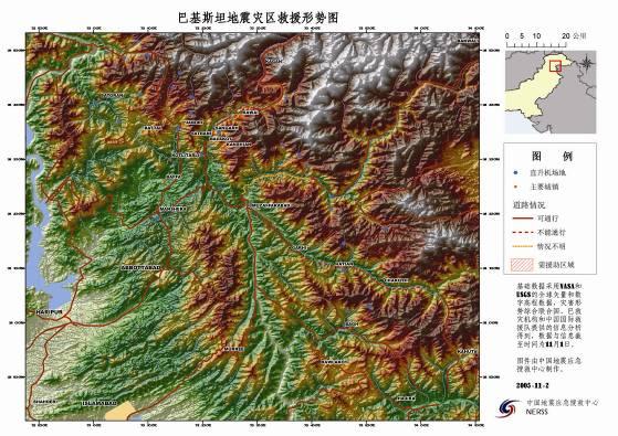
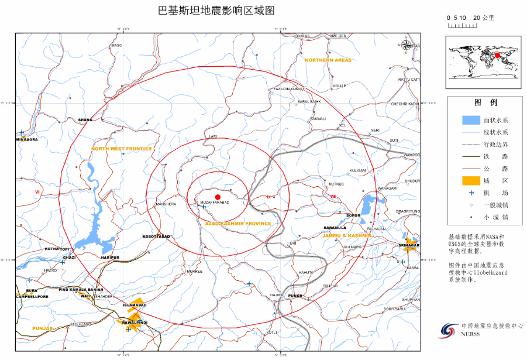
23 Sample map based on the global data

24 Sample map based on the global data 3D Map of BALAKOT North KAWAI SANGARH KANSHIAN BALAKOT JABORI SATBANI
25 Application of GEDAS
26 Future Work


27 Still need to be done
28 Thank You!
LandScan Global Population Database
 LandScan Global Population Database The World s Finest Population Distribution Data Uncommon information. Extraordinary places. LandScan Global Population Database East View Cartographic is now offering
HIGH RESOLUTION SATELLITE IMAGERY NEW PERSPECTIVES FOR THE EARTHQUAKE RISK MANAGEMENT
 HIGH RESOLUTION SATELLITE IMAGERY NEW PERSPECTIVES FOR THE EARTHQUAKE RISK MANAGEMENT Lucian CHIROIU Denis Diderot University, Pôle Image Laboratory Paris, France Geosciences Consultants Paris, France
Understanding China Census Data with GIS By Shuming Bao and Susan Haynie China Data Center, University of Michigan
 Understanding China Census Data with GIS By Shuming Bao and Susan Haynie China Data Center, University of Michigan The Census data for China provides comprehensive demographic and business information
Global Data Catalog initiative Christophe Charpentier ArcGIS Content Product Manager
 Global Data Catalog initiative Christophe Charpentier ArcGIS Content Product Manager ccharpentier@esri.com We are in a global economy Global Economy Business and Operations are now global Strategic need
GIS and Remote Sensing Support for Evacuation Analysis
 GIS and Remote Sensing Support for Evacuation Analysis Presented to GIS for Transportation Symposium Rapid City, South Dakota March 28-31, 2004 Demin Xiong Oak Ridge National Laboratory 2360 Cherahala
Pacific Catastrophe Risk Assessment And Financing Initiative
 Pacific Catastrophe Risk Assessment And Financing Initiative VANUATU September 211 Country Risk Profile: VANUATU is expected to incur, on average, 48 million USD per year in losses due to earthquakes and
THE STUDY ON 4S TECHNOLOGY IN THE COMMAND OF EARTHQUAKE DISASTER EMERGENCY 1
 THE STUDY ON 4S TECHNOLOGY IN THE COMMAND OF EARTHQUAKE DISASTER EMERGENCY 1 Zhou Wensheng 1, Huang Jianxi 2, Li Qiang 3, Liu Ze 3 1 Associate Professor, School of Architecture, Tsinghua University, Beijing.
Initiative. Country Risk Profile: papua new guinea. Better Risk Information for Smarter Investments PAPUA NEW GUINEA.
 Pacific Catastrophe Risk Assessment And Financing Initiative PAPUA NEW GUINEA September 211 Country Risk Profile: papua new is expected to incur, on average, 85 million USD per year in losses due to earthquakes
Pacific Catastrophe Risk Assessment And Financing Initiative
 Pacific Catastrophe Risk Assessment And Financing Initiative PALAU September is expected to incur, on average,.7 million USD per year in losses due to earthquakes and tropical cyclones. In the next 5 years,
CASUALTY IN EARTHQUAKE AND TSUNAMI DISASTERS: INTERNET-BASED MONITORING AND EARLY ESTIMATION OF THE FINAL DEATH TOLL
 CASUALTY IN EARTHQUAKE AND TSUNAMI DISASTERS: INTERNET-BASED MONITORING AND EARLY ESTIMATION OF THE FINAL DEATH TOLL ABSTRACT : Y.Z. Zhao 1, Z.L. Wu 2 and Y.T. Li 2, 3 1 College of Earth Science, Graduate
Pacific Catastrophe Risk Assessment And Financing Initiative
 Pacific Catastrophe Risk Assessment And Financing Initiative TIMOR-LESTE September Timor-Leste is expected to incur, on average, 5.9 million USD per year in losses due to earthquakes and tropical cyclones.
Advanced Image Analysis in Disaster Response
 Advanced Image Analysis in Disaster Response Creating Geographic Knowledge Thomas Harris ITT The information contained in this document pertains to software products and services that are subject to the
DESIGN HUMAN-COMPUTER INTERACTION SYSTEM TO BUILD ISOSEISMAL.
 ABSTRACT : DESIGN HUMAN-COMPUTER INTERACTION SYSTEM TO BUILD ISOSEISMAL. Ping Li 1 and Xiaxin Tao 2 1. PHD candidate, School of Civil Engineering, Harbin Institute of Technology, Harbin. China 2. Professor,
EMERGENCY PLANNING IN NORTHERN ALGERIA BASED ON REMOTE SENSING DATA IN RESPECT TO TSUNAMI HAZARD PREPAREDNESS
 EMERGENCY PLANNING IN NORTHERN ALGERIA BASED ON REMOTE SENSING DATA IN RESPECT TO TSUNAMI HAZARD PREPAREDNESS Barbara Theilen-Willige Technical University of Berlin, Institute of Applied Geosciences Department
Road & Railway Network Density Dataset at 1 km over the Belt and Road and Surround Region
 Journal of Global Change Data & Discovery. 2017, 1(4): 402-407 DOI:10.3974/geodp.2017.04.03 www.geodoi.ac.cn 2017 GCdataPR Global Change Research Data Publishing & Repository Road & Railway Network Density
Current Landscape of Spatial Decision Support Systems (SDSS) and Software Applications for Earthquake Disaster Management in Turkey
 and Software Applications for Earthquake Disaster Management in Turkey") Presented at the FIG Congress 2018, May 6-11, 2018 in Istanbul, Turkey Current Landscape of Spatial Decision Support Systems (SDSS) and Software Applications for Earthquake Disaster Management in Turkey
Presented at the FIG Congress 2018, May 6-11, 2018 in Istanbul, Turkey Current Landscape of Spatial Decision Support Systems (SDSS) and Software Applications for Earthquake Disaster Management in Turkey
RiskCity Training package on the Application of GIS for multi- hazard risk assessment in an urban environment.
 RiskCity Training package on the Application of GIS for multi- hazard risk assessment in an urban environment. Cees van Westen (Westen@itc.nl) & Nanette C. Kingma (Kingma@itc.nl) ITC: Training & Research
Pacific Catastrophe Risk Assessment And Financing Initiative
 Pacific Catastrophe Risk Assessment And Financing Initiative TUVALU is expected to incur, on average,. million USD per year in losses due to earthquakes and tropical cyclones. In the next 5 years, has
THE 3D SIMULATION INFORMATION SYSTEM FOR ASSESSING THE FLOODING LOST IN KEELUNG RIVER BASIN
 THE 3D SIMULATION INFORMATION SYSTEM FOR ASSESSING THE FLOODING LOST IN KEELUNG RIVER BASIN Kuo-Chung Wen *, Tsung-Hsing Huang ** * Associate Professor, Chinese Culture University, Taipei **Master, Chinese
The U.S. Geological Survey (USGS) National Earthquake Information Center (NEIC)
 National Earthquake Information Center (NEIC)") The U.S. Geological Survey (USGS) National Earthquake Information Center (NEIC) Gavin Hayes U.S. Geological Survey, National Earthquake Information Center NEIC Mission NEIC - The People 24x7 Operations
The U.S. Geological Survey (USGS) National Earthquake Information Center (NEIC) Gavin Hayes U.S. Geological Survey, National Earthquake Information Center NEIC Mission NEIC - The People 24x7 Operations
Copernicus Overview. Major Emergency Management Conference Athlone 2017
 Copernicus Overview Major Emergency Management Conference Athlone 2017 Copernicus is a European programme implemented by the European Commission. The services address six thematic areas: land, marine,
The AIR Bushfire Model for Australia
 The AIR Bushfire Model for Australia In February 2009, amid tripledigit temperatures and drought conditions, fires broke out just north of Melbourne, Australia. Propelled by high winds, as many as 400
Introduction. Elevation Data Strategy. Status and Next Steps
 1 2 Introduction Elevation Data Strategy Status and Next Steps 3 Canada is the 2nd largest country in the world - 9.9 million sq km Surrounded by 3 oceans with 202 000 km of coastline Population over 35
CLICK HERE TO KNOW MORE
 CLICK HERE TO KNOW MORE Geoinformatics Applications in Land Resources Management G.P. Obi Reddy National Bureau of Soil Survey & Land Use Planning Indian Council of Agricultural Research Amravati Road,
THE INTEGRATED INFORMATION SYSTEM FOR NATURAL
 THE INTEGRATED INFORMATION SYSTEM FOR NATURAL DISASTER MITIGATION Junxiu Wu 1, Qiang Feng 2*, Bijun Liang 3, and Angsheng Wang 4 1 Department of Computer System, Technological Bureau of Xinhua News Agency,
HAZUS-MH: Earthquake Event Report
 HAZUS-MH: Earthquake Event Report Region Name: El Paso County Earthquake Scenario: El Paso County Random EQ Print Date: February 08, 2006 Disclaimer: The estimates of social and economic impacts contained
Urban Process and Future Development of Colombo Metropolitan Area, Sri Lanka: An Application of Geospatial Techniques
 Urban Process and Future Development of Colombo Metropolitan Area, Sri Lanka: An Application of Geospatial Techniques January 2017 Suwandaralalage Indika Shyamantha SUBASINGHE Urban Process and Future
RAPID EXPOSURE AND LOSS ESTIMATES FOR THE MAY 12, 2008 Mw 7.9 WENCHUAN EARTHQUAKE PROVIDED BY THE U.S. GEOLOGICAL SURVEY S PAGER SYSTEM
 RAPID EXPOSURE AND LOSS ESTIMATES FOR THE MAY 12, 2008 Mw 7.9 WENCHUAN EARTHQUAKE PROVIDED BY THE U.S. GEOLOGICAL SURVEY S PAGER SYSTEM ABSTRACT : P.S. Earle 1, D.J. Wald 1, T.I. Allen 1, K.S. Jaiswal
2014/TPTWG/WKSP/013 Responding to Global Earthquake Hazards
 2014/TPTWG/WKSP/013 Responding to Global Earthquake Hazards Submitted by: United States Workshop on Improving Global Supply Chain Resilience: Advancing the Seven APEC Principles in Your Organization Christchurch,
Landslide Susceptibility Mapping Using Logistic Regression in Garut District, West Java, Indonesia
 Landslide Susceptibility Mapping Using Logistic Regression in Garut District, West Java, Indonesia N. Lakmal Deshapriya 1, Udhi Catur Nugroho 2, Sesa Wiguna 3, Manzul Hazarika 1, Lal Samarakoon 1 1 Geoinformatics
ENV208/ENV508 Applied GIS. Week 1: What is GIS?
 ENV208/ENV508 Applied GIS Week 1: What is GIS? 1 WHAT IS GIS? A GIS integrates hardware, software, and data for capturing, managing, analyzing, and displaying all forms of geographically referenced information.
INDIANA ACADEMIC STANDARDS FOR SOCIAL STUDIES, WORLD GEOGRAPHY. PAGE(S) WHERE TAUGHT (If submission is not a book, cite appropriate location(s))
 WHERE TAUGHT (If submission is not a book, cite appropriate location(s))") Prentice Hall: The Cultural Landscape, An Introduction to Human Geography 2002 Indiana Academic Standards for Social Studies, World Geography (Grades 9-12) STANDARD 1: THE WORLD IN SPATIAL TERMS Students
Prentice Hall: The Cultural Landscape, An Introduction to Human Geography 2002 Indiana Academic Standards for Social Studies, World Geography (Grades 9-12) STANDARD 1: THE WORLD IN SPATIAL TERMS Students
Establishment of WINDS Ground Station in Sri Lanka. By G.K.D. Amarawardena Additional Secretary Ministry of Disaster Management Sri Lanka
 Establishment of WINDS Ground Station in Sri Lanka By G.K.D. Amarawardena Additional Secretary Ministry of Disaster Management Sri Lanka Contents Background SAS Implementation Progress of WINDS establishment
Layout Optimization of Urban Underground Pipeline based on 3D Digital City
 中国科学院深圳先进技术研究院 SHENZHEN INSTITUTES OF ADVANCED TECHNOLOGY CHINESE ACADEMY OF SCIENCES Layout Optimization of Urban Underground Pipeline based on 3D Digital City Jianchun He, Jinxing Hu, Qingyuan Tang,
Geospatial framework for monitoring SDGs/Sendai targets By Shimonti Paul Sr. Assistant Editor Geospatial Media & Communications
 Geospatial framework for monitoring SDGs/Sendai targets By Shimonti Paul Sr. Assistant Editor Geospatial Media & Communications Outline 1. Introduction to Geospatial Media and Communications 2. Geospatial
Grade 6 Social Studies
 Unit Title: Africa : Movement Location Place Human Region : Subject/Course: 6 th Grade Social Studies Essential Questions: peoples, cultures and ideas of the world? How is a location identified using map
Report of the Working Group 2 Data Sharing and Integration for Disaster Management *
 UNITED NATIONS E/CONF.104/6 ECONOMIC AND SOCIAL COUNCIL Twentieth United Nations Regional Cartographic Conference for Asia and the Pacific Jeju, 6-9 October 2015 Item 5 of the provisional agenda Report
Digitization in a Census
 Topics Connectivity of Geographic Data Sketch Maps Data Organization and Geodatabases Managing a Digitization Project Quality and Control Topology Metadata 1 Topics (continued) Interactive Selection Snapping
Earthquake Disaster Assessment on May 27 Ms 6.2 Yogyakarta Earthquake of Indonesia
 Earthquake Disaster Assessment on May 27 Ms 6.2 Yogyakarta Earthquake of Indonesia Qu Guosheng, Zhao Fengxin, Huang Jianfa, Li Yigang, Li Yanfeng, Du Xiaoxia and Ning Baokun1 National Earthquake Response
Uses of free satellite imagery for Disaster Risk Reduction (DRR)
") Centre of Applied Geoscience, Disaster Risk Reduction Research Group, School of Earth and Environmental Science, University of Portsmouth, UK Uses of free satellite imagery for Disaster Risk Reduction
Centre of Applied Geoscience, Disaster Risk Reduction Research Group, School of Earth and Environmental Science, University of Portsmouth, UK Uses of free satellite imagery for Disaster Risk Reduction
DRAFT Methodology for Remote Sensing and GIS Analysis for Multiple Indicator Rapid Need Assessment (MIRA)
") DRAFT Methodology for Remote Sensing and GIS Analysis for Multiple Indicator Rapid Need Assessment (MIRA) Context and background/introduction: The Multi-sector Initial Rapid Assessment (MIRA) is the first
DRAFT Methodology for Remote Sensing and GIS Analysis for Multiple Indicator Rapid Need Assessment (MIRA) Context and background/introduction: The Multi-sector Initial Rapid Assessment (MIRA) is the first
World Meteorological Organization
 World Meteorological Organization Opportunities and Challenges for Development of Weather-based Insurance and Derivatives Markets in Developing Countries By Maryam Golnaraghi, Ph.D. Head of WMO Disaster
Crisis Management and Natural Disasters Overview of JRC operational or pre-operational activities A. Annunziato, D. Al-Khudhairy
 Papagayo, Costarica 3-4 November 2009 Security Science and The Americas 1 Joint Research Centre (JRC) Crisis Management and Natural Disasters Overview of JRC operational or pre-operational activities A.
Report of PCGIAP to the 18 th United Nations Regional Cartographic Conference for Asia and the Pacific (UNRCC-AP) for the period
 for the period") Permanent Committee on GIS Infrastructure for Asia and the Pacific (PCGIAP) Established in 1995 by a United Nations Resolution Report of PCGIAP to the 18 th United Nations Regional Cartographic Conference
Permanent Committee on GIS Infrastructure for Asia and the Pacific (PCGIAP) Established in 1995 by a United Nations Resolution Report of PCGIAP to the 18 th United Nations Regional Cartographic Conference
STEREO ANALYST FOR ERDAS IMAGINE Stereo Feature Collection for the GIS Professional
 STEREO ANALYST FOR ERDAS IMAGINE Stereo Feature Collection for the GIS Professional STEREO ANALYST FOR ERDAS IMAGINE Has Your GIS Gone Flat? Hexagon Geospatial takes three-dimensional geographic imaging
World Geography. WG.1.1 Explain Earth s grid system and be able to locate places using degrees of latitude and longitude.
 Standard 1: The World in Spatial Terms Students will use maps, globes, atlases, and grid-referenced technologies, such as remote sensing, Geographic Information Systems (GIS), and Global Positioning Systems
Using Remote Sensing Technologies to Improve Resilience
 4 Using Remote Sensing Technologies to Improve Resilience Ronald T. Eguchi CEO, ImageCat, Inc. 6 years ago The world had just survived the Y2K bug with no major incidents Nations around the world commit
IAEG-SDGs WGGI Task Team Dec. 7, 2017, New York
 IAEG-SDGs WGGI Task Team Dec. 7, 2017, New York Contents What are G/A data? Role of G/A data Utilization Recommendations Outlook National Geospatial Data for SDGs Official data products generated by authoritative
July 5-6, 2010 Mytilene, Greece
 Web GIS platform for forest fire management Prof. Kostas Kalabokidis Principal Investigator Univ. of the Aegean, Dept. of Geography, Greece Prof. George Kallos Univ. of Athens, Dept. of Physics, Greece
COMPREHENSIVE GIS-BASED SOLUTION FOR ROAD BLOCKAGE DUE TO SEISMIC BUILDING COLLAPSE IN TEHRAN
 COMPREHENSIVE GIS-BASED SOLUTION FOR ROAD BLOCKAGE DUE TO SEISMIC BUILDING COLLAPSE IN TEHRAN B. Mansouri 1, R. Nourjou 2 and K.A. Hosseini 3 1 Assistant Professor, Dept. of Emergency Management, International
Applied Geoscience and Technology Division SOPAC. Joy Papao, Risk Information Systems Officer
 Joy Papao, Risk Information Systems Officer Secretariat of the Pacific Community SPC 22 Pacific Island States Head office in Noumea, New Caledonia 2 Regional offices (Pohnpei and Honiara) 600 staff 9 Technical
Globally Estimating the Population Characteristics of Small Geographic Areas. Tom Fitzwater
 Globally Estimating the Population Characteristics of Small Geographic Areas Tom Fitzwater U.S. Census Bureau Population Division What we know 2 Where do people live? Difficult to measure and quantify.
Georeferencing and Satellite Image Support: Lessons learned, Challenges and Opportunities
 Georeferencing and Satellite Image Support: Lessons learned, Challenges and Opportunities Shirish Ravan shirish.ravan@unoosa.org UN-SPIDER United Nations Office for Outer Space Affairs (UNOOSA) UN-SPIDER
The Development of the Slope Failure Management System
 FANG Ji, Akiyuki KAWASAKI, Satoru SADOHARA The Development of the Slope Failure Management System There are many incidents of slope failure across Japan. The measures are required. Recently soft-measures
DETECTION OF CRUSTAL DEFORMATION OF THE NORTHERN PAKISTAN EARTHQUAKE BY SATELLITE DATA. Submitted by Japan **
 UNITED NATIONS E/CONF.97/5/CRP. 5 ECONOMIC AND SOCIAL COUNCIL Seventeenth United Nations Regional Cartographic Conference for Asia and the Pacific Bangkok, 18-22 September 2006 Item 6 (b) of the provisional
The Third UN-GGIM-AP Plenary Meeting. Use of Geospatial Information in Disaster and Coordination among NDMA and Relevant Organizations/Stakeholders
 The Third UN-GGIM-AP Plenary Meeting Use of Geospatial Information in Disaster and Coordination among NDMA and Relevant Organizations/Stakeholders Bali Indonesia 10 November 2014 Bernardus Wisnu Widjaja
Sustainable space system planning on urban disaster prevention and hazard assessment: a case study of Tainan metropolis, Taiwan
 The Sustainable City VIII, Vol. 2 1353 Sustainable space system planning on urban disaster prevention and hazard assessment: a case study of Tainan metropolis, Taiwan T.-Y. Chen 1,2, Y.-K. Chen 2, P.-K.
A Seismic Multi-Level Hybrid Grid System for Post-Earthquake Loss Assessment
 A Seismic Multi-Level Hybrid Grid System for Post-Earthquake Loss Assessment Xiaohong YANG 1,*, Yongzhi ZHANG 2, Jie LI 3 1 National Engineering Research Center of Geographic Information System, China
GIS-BASED EARTHQUAKE DISASTER PREDICTION AND OPTIMUM PATH ANALYSIS FOR THE URBAN ROAD TRANSIT SYSTEM
 GIS-BASED EARTHQUAKE DISASTER PREDICTION AND OPTIMUM PATH ANALYSIS FOR THE URBAN ROAD TRANSIT SYSTEM ABSTRACT: NI Yongjun 1, WANG Wanhong 1, HUANG Shimin 2, FU Shengcong 2 and OU Xianren 3 1. Ph.D, Associate
7.8M Earthquake in Nepal Situation Report No. 1
 EUROPEAN COMMISSION JOINT RESEARCH CENTRE Institute for the Protection and Security of the Citizen Global Security and Crisis Management Unit Sunday, 26 April 2015 7.8M Earthquake in Nepal Situation Report
Geographic Information Systems
 Geographic Information Systems What is a Geographic Information System (GIS)? definition of GIS - An internally referenced, automated, spatial information system for data mapping, management, and analysis
Geospatial Information and Services for Disasters (GIS4D)
") Geospatial Information and Services for Disasters (GIS4D) 31 July 2017 Tae Hyung KIM ICT and Disaster Risk Reduction Division (IDD) UNESCAP 1 About ESCAP Who is ESCAP? United Nations Economic and Social
Geospatial Information and Services for Disasters (GIS4D) 31 July 2017 Tae Hyung KIM ICT and Disaster Risk Reduction Division (IDD) UNESCAP 1 About ESCAP Who is ESCAP? United Nations Economic and Social
An Introduction to China and US Map Library. Shuming Bao Spatial Data Center & China Data Center University of Michigan
 An Introduction to China and US Map Library Shuming Bao Spatial Data Center & China Data Center University of Michigan Current Spatial Data Services http://chinadataonline.org China Geo-Explorer http://chinageoexplorer.org
DATA APPLIANCE FOR ARCGIS
 DATA APPLIANCE FOR ARCGIS Data Appliance for ArcGIS Provides Access to Multi-Scale Basemaps Down to Medium Scale Levels Worldwide And Large Scale for Most of the World The Data Appliance includes Several
F I G PA RT LX capacity in natural disaster area and disaster survey case in Jeju area
 F I G PA RT 7 2017. 12. 6. LX capacity in natural disaster area and disaster survey case in Jeju area Reporting order 1 2 3 General Information of LX Competence of LX on Natural disaster area Examples
3/29/11. Why bother with tools? Incorporating Decision Support Tools into Climate Adaptation Planning. A Simplified Planning Process
 Incorporating Decision Support Tools into Climate Adaptation Planning Why bother with tools? Tools don t eliminate complexity but they can help deal with it" Tools can:"! Help incorporate science into
José Luis Palma, William Rose and Rüdiger Escobar Wolf Department of Geological Engineering and Sciences Michigan Technological University
 Assessing the Volcanic Threat of Central American Volcanoes José Luis Palma, William Rose and Rüdiger Escobar Wolf Department of Geological Engineering and Sciences Michigan Technological University Outline
Earthquake,Tsunami,Volcano Monitoring & Warning System in Korea. Jimin Lee Earthquake & Volcano Monitoring Division KMA
 Earthquake,Tsunami,Volcano Monitoring & Warning System in Korea Jimin Lee Earthquake & Volcano Monitoring Division KMA 1 2 Brief History & Vision of KMA Introduction of Services 3 Korea National Seismographic
Trip Distribution Model for Flood Disaster Evacuation Operation
 Trip Distribution Model for Flood Disaster Evacuation Operation The devastating consequences of disasters in both developed and developing countries indicate significant lack or absence of disaster management
Introduction to Geographic Information Systems (GIS): Environmental Science Focus
: Environmental Science Focus") Introduction to Geographic Information Systems (GIS): Environmental Science Focus September 9, 2013 We will begin at 9:10 AM. Login info: Username:!cnrguest Password: gocal_bears Instructor: Domain: CAMPUS
Introduction to Geographic Information Systems (GIS): Environmental Science Focus September 9, 2013 We will begin at 9:10 AM. Login info: Username:!cnrguest Password: gocal_bears Instructor: Domain: CAMPUS
New Tsunami Disaster Mitigation System considering Local Conditions of Indian Ocean Rim Regions
 New Tsunami Disaster Mitigation System considering Local Conditions of Indian Ocean Rim Regions Kimiro Meguro Professor, Institute of Industrial Science, The University of Tokyo, Japan Shunichi Koshimura
Predicting Tsunami Inundated Area and Evacuation Road Based On Local Condition Using GIS
 IOSR Journal of Environmental Science, Toxicology and Food Technology (IOSR-JESTFT) ISSN: 2319-2402, ISBN: 2319-2399. Volume 1, Issue 4 (Sep-Oct. 2012), PP 05-11 Predicting Tsunami Inundated Area and Evacuation
Design of Safety Monitoring and Early Warning System for Buried Pipeline Crossing Fault
 5th International Conference on Civil Engineering and Transportation (ICCET 2015) Design of Safety Monitoring and Early Warning System for Buried Pipeline Crossing Fault Wu Liu1,a, Wanggang Hou1,b *, Wentao
Greg Collier, Battalion Chief Larry Fox, Captain Mount Laurel Fire Department
 Greg Collier, Battalion Chief Larry Fox, Captain Mount Laurel Fire Department Hurdles (NAVTEQ data Laurel Green example) Current software use map books field data (COP, OEM, disasters, critical infrastructure,
Investigation of the Effect of Transportation Network on Urban Growth by Using Satellite Images and Geographic Information Systems
 Presented at the FIG Congress 2018, May 6-11, 2018 in Istanbul, Turkey Investigation of the Effect of Transportation Network on Urban Growth by Using Satellite Images and Geographic Information Systems
Roles of NGII in successful disaster management
 The Second UN-GGIM-AP Plenary Meeting Roles of NGII in successful disaster management Republic of Korea Teheran Iran 28 October 2013 Sanghoon Lee, Ph.D. NGII Outline Type of Disasters Occur in Korea Practical
Overview. Tools of the Trade. USGS Decision-Making Tools for Pre-Earthquake Mitigation and Post-Earthquake Response
 USGS Decision-Making Tools for Pre-Earthquake Mitigation and Post-Earthquake Response Tools of the Trade DAVID WALD United States Geological Survey NEHRP Workshop: Developing Earthquake Scenarios Sept
Spanish national plan for land observation: new collaborative production system in Europe
 ADVANCE UNEDITED VERSION UNITED NATIONS E/CONF.103/5/Add.1 Economic and Social Affairs 9 July 2013 Tenth United Nations Regional Cartographic Conference for the Americas New York, 19-23, August 2013 Item
Imagery and the Location-enabled Platform in State and Local Government
 Imagery and the Location-enabled Platform in State and Local Government Fred Limp, Director, CAST Jim Farley, Vice President, Leica Geosystems Oracle Spatial Users Group Denver, March 10, 2005 TM TM Discussion
Flood Hazard Mapping for Canada based on Spatial Data Integration and Modeling
 Flood Hazard Mapping for Canada based on Spatial Data Integration and Modeling Qiaoping Zhang 1, Michael Wollersheim 1, Natalie Findlay 1, Stephen Griffiths 1 1 Intermap Technologies Corp., Calgary, AB,
Interpretive Map Series 24
 Oregon Department of Geology and Mineral Industries Interpretive Map Series 24 Geologic Hazards, and Hazard Maps, and Future Damage Estimates for Six Counties in the Mid/Southern Willamette Valley Including
Summary Description Municipality of Anchorage. Anchorage Coastal Resource Atlas Project
 Summary Description Municipality of Anchorage Anchorage Coastal Resource Atlas Project By: Thede Tobish, MOA Planner; and Charlie Barnwell, MOA GIS Manager Introduction Local governments often struggle
Global Map: A Tool for Disaster Mitigation for the Asia and Pacific Region
 Global Map: A Tool for Disaster Mitigation for the Asia and Pacific Region D. R. Fraser Taylor Chair, International Steering Committee for Global Mapping (ISCGM) fraser_taylor@carleton.ca www. 18 th United
Application of a GIS for Earthquake Hazard Assessment and Risk Mitigation in Vietnam
 Application of a GIS for Earthquake Hazard Assessment and Risk Mitigation in Vietnam Nguyen Hong Phuong Earthquake Information and Tsunami Warning Centre, VAST OUTLINE Introduction Fault Source Model and
Remote Sensing the Urban Landscape
 Remote Sensing the Urban Landscape Urban landscape are composed of a diverse assemblage of materials (concrete, asphalt, metal, plastic, shingles, glass, water, grass, shrubbery, trees, and soil) arranged
Status & Challengers of Cook Islands GEO DRM. Cook Islands GEO S/GIS History
 Status & Challengers of Cook Islands GEO DRM By Patrick A. ARIOKA Planning & Advisory Officer EMERGENCY MANAGEMENT COOK ISLANDS Cook Islands GEO S/GIS History 1990 NZODA/MFAT trained by Landcare Research
Climate Resilience Decision Making Framework in the Caribbean. A case of Spatial Data Management
 Climate Resilience Decision Making Framework in the Caribbean A case of Spatial Data Management Bishwa Pandey Sr. Data Management Specialist The World Bank Background The mission of The World Bank s Latin
1. 1 What hazard maps have been developed in your country?
 REPUBLIC OF SLOVENIA MINISTRY OF DEFENCE ADMINISTRATION FOR CIVIL PROTECTION AND DISASTER RELIEF Kardeljeva plošcad 21, 1000 Ljubljana telephone: (+386) 1 471 33 22, fax: (+386) 1 431 81 17 ANSWERS TO
Geospatial natural disaster management
 Geospatial natural disaster management disasters happen. are you ready? Natural disasters can strike almost anywhere at any time, with no regard to a municipality s financial resources. These extraordinarily
Ground motion attenuation relations of small and moderate earthquakes in Sichuan region
 Earthq Sci (2009)22: 277 282 277 Doi: 10.1007/s11589-009-0277-x Ground motion attenuation relations of small and moderate earthquakes in Sichuan region Lanchi Kang 1, and Xing Jin 1,2 1 Fuzhou University,
GIS and Remote Sensing
 Spring School Land use and the vulnerability of socio-ecosystems to climate change: remote sensing and modelling techniques GIS and Remote Sensing Katerina Tzavella Project Researcher PhD candidate Technology
GIS as a Management Tool in Nepal Earthquake Response
 GIS as a Management Tool in Nepal Earthquake Response Presenter: Charlie Charping GIS Manager Samaritan s Purse A CASE STUDY & LESSONS LEARNED Presentation Agenda Samaritan s Purse Background The Case
International Conference Analysis and Management of Changing Risks for Natural Hazards November 2014 l Padua, Italy
 Abstract Code: B01 Assets mapping products in support of preparedness and prevention measures (examples from Germany, Italy and France) Marc Mueller, Thierry Fourty, Mehdi Lefeuvre Airbus Defence and Space,
Texas A&M University
 Texas A&M University CVEN 658 Civil Engineering Applications of GIS Hotspot Analysis of Highway Accident Spatial Pattern Based on Network Spatial Weights Instructor: Dr. Francisco Olivera Author: Zachry
Introduction of Sichuan Surveying and Mapping Emergency System. Zheng Quanhong Sichuan Bureau of Surveying.Mapping and Geoinformation September 2016
 Introduction of Sichuan Surveying and Mapping Emergency System Zheng Quanhong Sichuan Bureau of Surveying.Mapping and Geoinformation September 2016 Background Sichuan province is one of the most serious
GEOMATICS. Shaping our world. A company of
 GEOMATICS Shaping our world A company of OUR EXPERTISE Geomatics Geomatics plays a mayor role in hydropower, land and water resources, urban development, transport & mobility, renewable energy, and infrastructure
PLACE-BASED INFORMATION MANAGEMENT FOR ECONOMIC GROWTH ADMINISTRATION OF LAND AFFAIRS, GEODESY AND CARTOGRAPHY
 PLACE-BASED INFORMATION MANAGEMENT FOR ECONOMIC GROWTH ADMINISTRATION OF LAND AFFAIRS, GEODESY AND CARTOGRAPHY 5 October 2012 CONTENTS Current situation of Geospatial information in Mongolia Usage of geospatial
Mapping Coastal Change Using LiDAR and Multispectral Imagery
 Mapping Coastal Change Using LiDAR and Multispectral Imagery Contributor: Patrick Collins, Technical Solutions Engineer Presented by TABLE OF CONTENTS Introduction... 1 Coastal Change... 1 Mapping Coastal
NCC roles in successful disaster response I.R.IRAN
 The Second UN-GGIM-AP Plenary Meeting NCC roles in successful disaster response I.R.IRAN Teheran Iran 28-30 October 2013 Ali Javidaneh Technical Deputy of National Cartographic Center (NCC) Outline Types
Applications of GIS in Electrical Power System. Dr. Baqer AL-Ramadan Abdulrahman Al-Sakkaf
 Applications of GIS in Electrical Power System Dr. Baqer AL-Ramadan Abdulrahman Al-Sakkaf OUTLINES: Objective Importance of GIS GIS data development Application of GIS Findings Conclusions and Recommendations