Hazard and Vulnerability of Moderate Seismicity Regions
|
|
|
- Marcus Smith
- 5 years ago
- Views:
Transcription


1 Hazard and Vulnerability of Moderate Seismicity Regions presented by Professor Tso-Chien PAN Dean, College of Engineering Director, 25 October 2010 DRM GDLN Session on Earthquake Vulnerability Reduction
2 Outline Why the focus on Asia General Framework for Seismic Risk Assessment Seismic Hazard Source: Regional Seismicity Site Effects: Soft Soil Amplification of Ground Motions Seismic Vulnerability Exposure: Built Environment Vulnerability: Lightly Reinforced Concrete Joints Summary
3 Why the focus on Asia Historically, Asia has suffered the most due to catastrophic events. Asia has the largest growth of real assets and urban centers on Earth. This has exacerbated the problems of seismic risk management. Climate Change issues will potentially impact Asia more than any other continent.
4 Historical Earthquake Loss ( ) Number of killed Rest of the World, 190,000 Number of affected Rest of the World, 32,000,000 Asia, 126,000,000 Asia, 920,000 Total = 1,110,000 Estimated Damage (USD Million) Rest of the World, 133,000 Total = 158,000,000 Asia, 315,000 Total = 448,000 Source: EM-DAT: The OFDA/CRED International Disaster Database Université Catholique de Louvain Brussels Belgium.
5 Rapid Growth Top 15 Mega-Cities (2009) 1. Tokyo Japan Asia 33,800, Seoul South Korea Asia 23,900, Mexico City Mexico North America 22,900, Delhi India Asia 22,400, Mumbai India Asia 22,300, New York USA North America 21,900, Sao Paulo Brazil South America 21,000, Manila Philippines Asia 19,200, Los Angeles USA North America 18,000, Shanghai China Asia 17,900, Osaka Japan Asia 16,700, Kolkata India Asia 16,000, Karachi Pakistan Asia 15,700, Guangzhou China Asia 15,300, Jakarta Indonesia Asia 15,100,000
6 General Framework for Seismic Risk Assessment EQ Source Modelling Path Directivity Site Soil Rock Building Response Risk Assessment & Loss Estimate: HAZUS, eg Hazards: Peak Ground Acceleration and/or Spectra Vulnerability: Buildings and Infrastructure

 Sb 13 Sep 2007 03:35:26 Sp 12 Sep 2007 23:49:01-3 28 Mar 2005 & NP SP Palembang 1861")
 1797 Medan Sumatra")
7 Framework for Seismic Risk Assessment Dec 2004 Penang Malay Peninsula Eurasian Plate Source: Magnitude 7.8 and 8.8 earthquakes Loss Assessment: Direct and Indirect Losses Latitude ( o ) 3 Sm Ni 0 Bt Pekanbaru 52 mm/yr Padang (N10 o E) Sb 13 Sep :35:26 Sp 12 Sep :49: Mar 2005 & NP SP Palembang 1861 Bengkulu 12 Sep :10:26 Scenario A En mm/yr Jakarta Scenarios B & C Java 60 mm/yr -9 (N17 o E) km Indian-Australian Plate Longitude ( o ) 1797 Medan Sumatra Sumatran Fault 1833 Path Kuala Lumpur Singapore Site Site Effects Exposures: Buildings & Infrastructure

8 The Earth s Crustal Plate

9 Southeast Asia Myanmar Laos Thailand Vietnam Cambodia Philippines Malaysia Brunei Singapore Indonesia
10 Latitude ( o ) Regional Tectonic Setting Sumatra Fault mm/yr (N10 o E) Sumatra Subduction 57 mm/yr Penang Indian-Australian Plate 60 mm/yr (N17 o E) Malay Peninsula Medan Kuala Lumpur km Pekan Baru Sumatra Singapore Palembang Longitude ( o ) Eurasian Plate Java Singapore is located in a stable region on the Eurasian Plate Sumatra subduction (± 650 km away): Shallow dipping Very high seismic potential Sumatra fault (± 450 km away): Right-lateral faulting Total length is 1,900 km Highly segmented

11 Features of Subduction subduction interface Oceanic fracture zone Sumatran fault Obliquity of subduction has led to formation of the Sumatra fault, within the volcanic arc. Splintering of the subducting oceanic plate occurs along faults within the downgoing slab.

12 Epicentres of Sumatra EQs with M 6.5 ( )


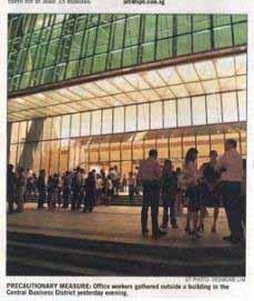
13 Padang, Sumatra Earthquake (Mw=6.3) Evacuation at Suntec City Towers and other high-rise buildings in the central business district area
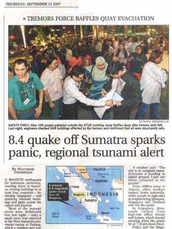
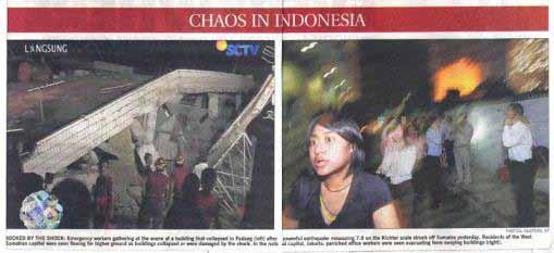
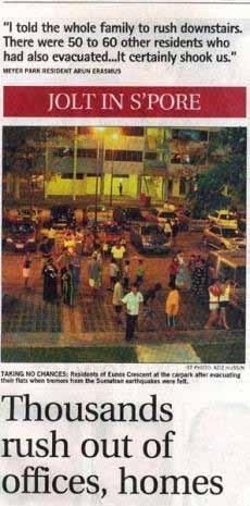
14 Bengkulu-Mentawai Earthquake (Mw=8.4)
15 Bengkulu-Mentawai Earthquake (Mw=8.4,7.9,7.0) Historical and 2007 rupture areas

16 Giant Earthquakes Since 2000 Singapore

17 Kepulauan Mentawai EQ, Indonesia, M=7.5 ( :42:22 UTC)

18 Historical Seismicity Sumatra EQs Felt in Singapore ( )

19 Sumatran EQs Felt in Singapore per Decade As of 22 July 2010 Number of events


20 Singapore s Waterfront Skyline Classic Change in Exposure due to Urbanization What if the 1833 event recurs? Codes for EQ resistant design of buildings for long-distance EQs (circa 1960) (circa 2000)
21 Site Effects - Singapore Surface Geology


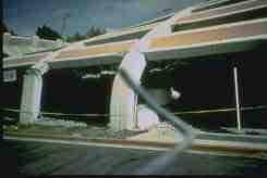
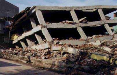
22 Buildings Responded to Sumatra Events before Bengkulu EQ
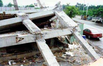
23 Buildings Responded to Bengkulu EQ


24 Development of Public Housing Home to a large % of population
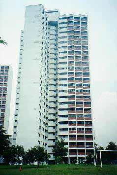
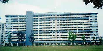
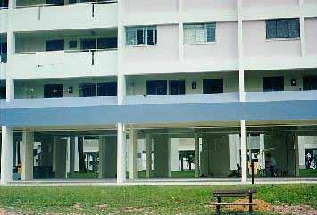
25 Some Structural Systems Slab Block Point Block

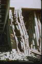
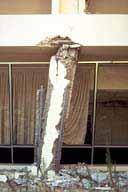
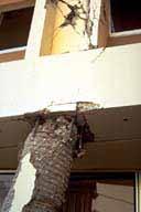
26 Seismic Performance of Reinforced Concrete Columns Brittle Ductile
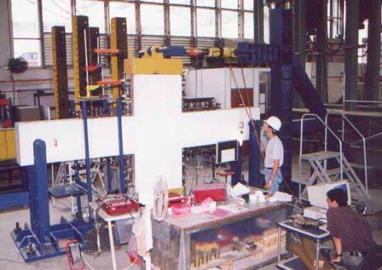
27 Seismic Performance: Beam Wide Column Joints


28 Seismic Performance: Lightly Reinforced Beam-Column Joints
29 Summary Hazard Assessment: Increased Seismic Activities Number of Sumatra events felt in Singapore Coinciding with high construction activities Vulnerability Assessment: Rapid Urbanization Increased number of buildings and taller buildings Site-Dependent Building Response Softer sites are more responsive to distant earthquakes Lightly Reinforced Concrete Beam-Column Joints Responding differently from RC joints designed for buildings in high-seismic regions
30 Thank you! Q&A

31 The 30 Sep 2009 Padang Earthquake Date: 2009/ 9/30 Centroid Time: 10:16:17.4 GMT Lat= Lon= Depth= 75.8 Half duration=14.5 Centroid time minus hypocenter time: 8.4 Moment Tensor: Expo= Mw = 7.5 mb = 7.6 Ms = 7.6 Scalar Moment = 2.64e+27 Fault plane: strike=72 dip=51 slip=136 Fault plane: strike=193 dip=58 slip=49

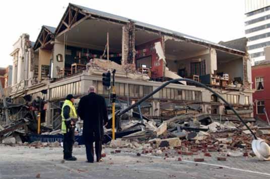
32 Christchurch, NZ, Earthquake, M=7.1, 4 Sept 2010 Occurred at a location away from the well known Fault Line: Alpine Fault Fault ruptured has remained dormant for 16,000 years. 7.1, 3 rd September 2010

33 Damage of Masonry Components
The Earthquake of Padang, Sumatra of 30 September 2009 scientific information and update
 The Earthquake of Padang, Sumatra of 30 September 2009 scientific information and update 01-October-2009 Christophe Vigny Directeur de recherches at CNRS Laboratoire de Géologie Geoscience Dept. Of ENS,
THE EFFECT OF THE LATEST SUMATRA EARTHQUAKE TO MALAYSIAN PENINSULAR
 JURNAL KEJURUTERAAN AWAM (JOURNAL OF CIVIL ENGINEERING) Vol. 15 No. 2, 2002 THE EFFECT OF THE LATEST SUMATRA EARTHQUAKE TO MALAYSIAN PENINSULAR Assoc. Prof. Dr. Azlan Adnan Hendriyawan Structural Earthquake
FOCAL MECHANISMS OF SUBDUCTION ZONE EARTHQUAKES ALONG THE JAVA TRENCH: PRELIMINARY STUDY FOR THE PSHA FOR YOGYAKARTA REGION, INDONESIA
 FOCAL MECHANISMS OF SUBDUCTION ZONE EARTHQUAKES ALONG THE JAVA TRENCH: PRELIMINARY STUDY FOR THE PSHA FOR YOGYAKARTA REGION, INDONESIA Myo Thant 1, Hiroshi Kawase 2, Subagyo Pramumijoyo 3, Heru Hendrayana
Earth Issue: November 2017
 Earth Issue: November 2017 Earthquake Risk In Indonesia Damage in Banda Aceh During 2004 tsunami Source: US Military The Indonesian archipelago is located at the boundary of three major tectonic plates,
Inquiry: Sumatran earthquakes with GPS Earth Science Education
 Inquiry: Sumatran earthquakes with GPS Earth Science Education www.earthobservatory.sg Preparation: Before doing this investigation, complete two introductory investigations using GPS data from UNAVCO
2018 REVIEW OF DISASTER EVENTS
 2018 REVIEW OF DISASTER EVENTS Supplementary Information* BRUSSELS, 24 January, 2019 In 2018, there were 281 climate-related and geophysical events recorded in the EM-DAT (International Disaster Database)
Tectonic Processes and Hazards Enquiry Question 1: Why are some locations more at risk from tectonic hazards?
 Tectonic Processes and Hazards Enquiry Question 1: Why are some locations more at risk from tectonic hazards? Key words Basalt Andesite Rhyolite Benioff Zone Subduction zone Crustal fracturing Definition
PADANG EARTHQUAKE, WEST SUMATRA ON MARCH 6, 2007
 PADANG EARTHQUAKE, WEST SUMATRA ON MARCH 6, 2007 EARTHQUAKE DETAILS The U. S. Geological Survey (USGS) informed a strong earthquake struck west Sumatra on Tuesday March 6, 2007 at 10:49 with a magnitude
Malaysian Journal of Civil Engineering 22(1) : (2010) Malaysia
 : (2010) Malaysia") AN INVESTIGATION ON THE ATTENUATION CHARACTERISTICS OF DISTANT GROUND MOTIONS IN PENINSULAR MALAYSIA BY COMPARING VALUES OF RECORDED WITH ESTIMATED PGA AND PGV Sherliza Zaini Sooria 1*, Sumio Sawada 2,
AN INVESTIGATION ON THE ATTENUATION CHARACTERISTICS OF DISTANT GROUND MOTIONS IN PENINSULAR MALAYSIA BY COMPARING VALUES OF RECORDED WITH ESTIMATED PGA AND PGV Sherliza Zaini Sooria 1*, Sumio Sawada 2,
REGIONAL GROUND MOTION PREDICTION AND DATABASE
 REGIONAL GROUND MOTION PREDICTION AND DATABASE 1.1 Identification of Primary input parameters a. Magnitudes and intensities of historical Earthquake In this recent century, Indonesia has been impacted
M 7.1 EARTHQUAKE 5KM ENE OF RABOSO, MEXICO EXACT LOCATION: N W DEPTH: 51.0KM SEPTEMBER 19, 1:14 LOCAL TIME
 M 7.1 EARTHQUAKE 5KM ENE OF RABOSO, MEXICO EXACT LOCATION: 18.584 N 98.399 W DEPTH: 51.0KM SEPTEMBER 19, 2017 @ 1:14 LOCAL TIME Photo: Eduardo Verdugo / AP Photo: Alfredo Estrella/ Agence France-Presse/
5-31. Cambodia. Vietnam. South China S ea. Malaysia. Kuala L umpur. Singapore. Kalimantan. Sunda S trait. Jakarta. Java 98E. Sumatra. Pini.
 5-31 Ridge Ninetyeast 52mm/yr Wharton For e S umatran Ridge Indian Andaman Sea arc 1861 Burma Ridge 1833 Thailand Sumatran Sliver Subduction Southeast Asian P late Malaysia Fault P Cambodia Kuala L umpur
Report on Banda Aceh mega-thrust earthquake, December 26, 2004
 Report on Banda Aceh mega-thrust earthquake, December 26, 2004 Prepared January 7 th 2005 by C. Vigny, on behalf of the SEAMERGES (*) participants On the morning of December 26 th in SE Asia, 30 km below
Lessons from the 2004 Sumatra earthquake and the Asian tsunami
 Lessons from the 2004 Sumatra earthquake and the Asian tsunami Kenji Satake National Institute of Advanced Industrial Science and Technology Outline 1. The largest earthquake in the last 40 years 2. Tsunami
Earthquakes. Earthquake Magnitudes 10/1/2013. Environmental Geology Chapter 8 Earthquakes and Related Phenomena
 Environmental Geology Chapter 8 Earthquakes and Related Phenomena Fall 2013 Northridge 1994 Kobe 1995 Mexico City 1985 China 2008 Earthquakes Earthquake Magnitudes Earthquake Magnitudes Richter Magnitude
Pacific Catastrophe Risk Assessment And Financing Initiative
 Pacific Catastrophe Risk Assessment And Financing Initiative TIMOR-LESTE September Timor-Leste is expected to incur, on average, 5.9 million USD per year in losses due to earthquakes and tropical cyclones.
Magnitude 7.5 PALU, INDONESIA
 A magnitude 7.5 earthquake occurred 80.8 km (50.2 mi) north of Palu, Indonesia at a depth of 10 km (6.2 miles). This earthquake triggered a tsunami with wave heights up to 2 m (6.6 ft) that an official
Report on Banda Aceh mega-thrust earthquake, December 26, 2004
 Report on Banda Aceh mega-thrust earthquake, December 26, 2004 Prepared January 7 th 2005 by C. Vigny, on behalf of the SEAMERGES (*) participants On the morning of December 26 th, 2004 in SE Asia, 30
M-8.1 EARTHQUAKE 87KM SW OF PIJIJIAPAN, MEXICO EXACT LOCATION: N W DEPTH: 69.7KM SEPTEMBER 7, 11:49 PST
 M-8.1 EARTHQUAKE 87KM SW OF PIJIJIAPAN, MEXICO EXACT LOCATION: 15.068 N 93.715 W DEPTH: 69.7KM SEPTEMBER 7, 2017 @ 11:49 PST Photo: Luis Alberto Cruz / AP Photo: Carlos Jasso 1 THE 2017 CHIAPAS MEXICO
CITIES WITHOUT A SEISMIC CODE I: HAZARD ASSESSMENT
 13 th World Conference on Earthquake Engineering Vancouver, B.C., Canada August 1-6, 2004 Paper No. 129 CITIES WITHOUT A SEISMIC CODE I: HAZARD ASSESSMENT Kusnowidjaja MEGAWATI 1, Nelson T.K. LAM 2, Adrian
STUDY ON TSUNAMIGENIC EARTHQUAKE CRITERIA FOR THE INDONESIAN TSUNAMI EARLY WARNING SYSTEM
 STUDY ON TSUNAMIGENIC EARTHQUAKE CRITERIA FOR THE INDONESIAN TSUNAMI EARLY WARNING SYSTEM Nanang T. Puspito 1 1 Geophysics Research Group, Faculty of Mining and Petroleum Engineering, Institute of Technology
SEISMIC HAZARD ANALYSIS AND SEISMIC INPUT TO TSUNAMI MODELING FOR MICROZONATION OF MEURAXA DISTRICT CITY OF BANDA ACEH
 SEISMIC HAZARD ANALYSIS AND SEISMIC INPUT TO TSUNAMI MODELING FOR MICROZONATION OF MEURAXA DISTRICT CITY OF BANDA ACEH I W. Sengara 1, Hendarto 1, P. Sumiartha 1, H. Latief 1, S.B. Kusuma 1 and Munirwansjah
Tsunami and earthquake in Chile Part 2
 EUROPEAN COMMISSION DIRECTORATE GENERAL JRC JOINT RESEARCH CENTRE Institute for the Protection and Security of the Citizen Global Security and Crisis Management Unit CriTech Sunday, 28 February 2010 Executive
LAB 9: Earthquakes & Seismic Activity
 LAB 9: Earthquakes & Seismic Activity Objectives Identify P, S, and surface waves on a simple seismogram Locate the epicenter of an earthquake using seismograms and travel times curves Describe how the
SIMULATION OF A WORST CASE TSUNAMI SCENARIO FROM THE MANILA TRENCH TO VIETNAM
 SIMULATION OF A WORST CASE TSUNAMI SCENARIO FROM THE MANILA TRENCH TO VIETNAM Nguyen Hong Phuong, Vu Ha Phuong, Pham The Truyen Earthquake Information and Tsunami Warning Centre, VAST OUTLINE Earthquake
History of International Training in Seismology and Earthquake Engineering at IISEE
 History of International Training in Seismology and Earthquake Engineering at IISEE Activities of International Institute of Seismology and Earthquake Engineering (IISEE), BRI - Training for young researchers/engineers
A RECONNAISANCE REPORT THE PISCO, PERU EARTHQUAKE OF AUGUST 15, 2007
 Pisco Earthquake, Peru, August 15, 2007 A RECONNAISANCE REPORT ON THE PISCO, PERU EARTHQUAKE OF AUGUST 15, 2007 Jörgen Johansson Tatiana Torres Paola Mayorca Edwin Leon 2007 Pisco, Peru Earthquake Reconnaissance
Natural Disasters in Member Countries (2002 Summary)
") 4.2 Member Countries and their Disaster Characteristics: Table 5: Natural Disasters in Member Countries (2002 Summary) (Country/Disaster Type/Disaster Characteristics) Data Country DisType Count of TotAff
4.2 Member Countries and their Disaster Characteristics: Table 5: Natural Disasters in Member Countries (2002 Summary) (Country/Disaster Type/Disaster Characteristics) Data Country DisType Count of TotAff
Earthquake Risk in Indonesia
 過去の火災事例 MM I TTSS UU I SSUU MMI I TTOO MMOO I NN SSUURR AA NN CC EE GG RR OOUUPP INTTEERRI I ISSK AASSI IAA PPTTEE LLTTD... Earthquake Risk in Indonesia October 2009 In Indonesia, the Sumatra Earthquake
News Release December 30, 2004 The Science behind the Aceh Earthquake
 News Release December 30, 2004 The Science behind the Aceh Earthquake PASADENA, Calif. - Kerry Sieh, the Robert P. Sharp Professor of Geology at the California Institute of Technology and a member of Caltech's
LESSON LEARNED FROM THE EFFECT OF RECENT FAR FIELD SUMATRA EARTHQUAKES TO PENINSULAR MALAYSIA
 13 th World Conference on Earthquake Engineering Vancouver, B.C., Canada August 1-6, 2004 Paper No. 416 LESSON LEARNED FROM THE EFFECT OF RECENT FAR FIELD SUMATRA EARTHQUAKES TO PENINSULAR MALAYSIA Azlan
Dense Ocean floor Network System for Earthquakes and Tsunamis DONET
 Dense Ocean floor Network System for Earthquakes and Tsunamis DONET Yoshiyuki Kaneda Japan Agency for Marine-Earth Science and Technology (JAMSTEC) ION 1 Earthquakes in the Nankai Trough Tokai Nankai Hyuga
TSUNAMI AND EARTHQUAKE ACTIVITY IN INDONESIA *
 LOCAL TSUNAMI WARNING AND MITIGATION TSUNAMI AND EARTHQUAKE ACTIVITY IN INDONESIA * Nanang T. Puspito Department of Geophysics and Meteorology, Institute of Technology Bandung (ITB) Address: Jalan Ganeca
Mw 7.8, Southwest of Sumatra, Indonesia Wed, 2 March 2016 at 12:49:48 UTC M /03/03
 Earthquake overview AFGHANISTA N PAKISTA N INDIA A moment magnitude (Mw) 7.8 earthquake struck in South West, Indonesia. The epicentre was centered about 800 km West South West of Padang, Sumatra province,
SDI Developments in the World s Currently Existing Mega Cities
 SDI Developments in the World s Currently Existing Mega Cities Silke Boos and Hartmut Müller FIG Working Week 2009 Surveyors Key Role in Accelerated Development, Eilat, Israel, 3-8 May 2009 TS 1B SDI in
Widespread Ground Motion Distribution Caused by Rupture Directivity during the 2015 Gorkha, Nepal Earthquake
 Widespread Ground Motion Distribution Caused by Rupture Directivity during the 2015 Gorkha, Nepal Earthquake Kazuki Koketsu 1, Hiroe Miyake 2, Srinagesh Davuluri 3 and Soma Nath Sapkota 4 1. Corresponding
Ömer AYDAN. Ismail FEBRIN. Fumihiko IMAMURA KOGAMI (Tsunami Alert Community-NPO)
") ( ) JSCE-JAEE Team Andalas University Ömer AYDAN Ismail FEBRIN Fumihiko IMAMURA Abdul HAKAM Mas MERA KOGAMI (Tsunami Alert Community-NPO) Tomoji SUZUKI Patra Rina DEWI 10 4 10 9 LOCATION Padang Sikuai
( ) JSCE-JAEE Team Andalas University Ömer AYDAN Ismail FEBRIN Fumihiko IMAMURA Abdul HAKAM Mas MERA KOGAMI (Tsunami Alert Community-NPO) Tomoji SUZUKI Patra Rina DEWI 10 4 10 9 LOCATION Padang Sikuai
Application of a GIS for Earthquake Hazard Assessment and Risk Mitigation in Vietnam
 Application of a GIS for Earthquake Hazard Assessment and Risk Mitigation in Vietnam Nguyen Hong Phuong Earthquake Information and Tsunami Warning Centre, VAST OUTLINE Introduction Fault Source Model and
STUDY ON APPROPRIATE MODELING OF TSUNAMIS IN MALAYSIA FOR RISK EVALUATION
 STUDY ON APPROPRIATE MODELING OF TSUNAMIS IN MALAYSIA FOR RISK EVALUATION Zaty Aktar binti Mokhtar* Supervisor: Fumihiko Imamura** MEE06025 Shunichi Koshimura** ABSTRACT In order to design a tsunami warning
International Research Collaboration in Indonesia: LIPI as a special reference
 Workshop on Science & Technology Cooperation With Developing Countries on Global Issues. Tokyo, 8 October 2008 International Research Collaboration in Indonesia: LIPI as a special reference Hery Harjono
AVERAGE AND VARIATION OF FOCAL MECHANISM AROUND TOHOKU SUBDUCTION ZONE
 13 th World Conference on Earthquake Engineering Vancouver, B.C., Canada August 1-6, 24 Paper No. 414 AVERAGE AND VARIATION OF FOCAL MECHANISM AROUND TOHOKU SUBDUCTION ZONE Shunroku YAMAMOTO 1 Naohito
held on 4 June 2013 Prof. Yoshimori Honkura, Program Officer of Japan Science and Technology Agency (JST) Jakarta, Indonesia Pan Pacific Hotel)
 Jakarta, Indonesia Pan Pacific Hotel)") Overview of the Outcomes from e-asia JRP Disaster Prevention Workshop held on 4 June 2013 Prof. Yoshimori Honkura, Program Officer of Japan Science and Technology Agency (JST) Jakarta, Indonesia (@Sari
Overview of the Outcomes from e-asia JRP Disaster Prevention Workshop held on 4 June 2013 Prof. Yoshimori Honkura, Program Officer of Japan Science and Technology Agency (JST) Jakarta, Indonesia (@Sari
Migration and Urban Decay
 Migration and Urban Decay Asian Experiences Shekhar Mukherji RAWAT PUBLICATIONS Jaipur New Delhi Bangalore Mumbai Contents Preface List of Tables List of Figures ix xv xix Introduction 1 Very Crucial Urban
Available online at ScienceDirect. Procedia Engineering 125 (2015 )
") Available online at www.sciencedirect.com ScienceDirect Procedia Engineering 125 (2015 ) 1094 1100 The 5th International Conference of Euro Asia Civil Engineering Forum (EACEF-5) A multi-hazard risk assessment
Available online at www.sciencedirect.com ScienceDirect Procedia Engineering 125 (2015 ) 1094 1100 The 5th International Conference of Euro Asia Civil Engineering Forum (EACEF-5) A multi-hazard risk assessment
LANDSLIDE MITIGATION IN CCOP
 "International Workshop on Landslide Risk Assessment and Management for ASEAN Member States 1-2 June 2017 Bangkok, Thailand LANDSLIDE MITIGATION IN CCOP Dr. Adichat Surinkum Director Email: adichat_s@ccop.or.th,
Pacific Catastrophe Risk Assessment And Financing Initiative
 Pacific Catastrophe Risk Assessment And Financing Initiative VANUATU September 211 Country Risk Profile: VANUATU is expected to incur, on average, 48 million USD per year in losses due to earthquakes and
The Tectonic Setting of New Zealand
 The Tectonic Setting of New Zealand we are here Subduction-driven tectonics The New Zealand continent Papua New Guinea Australia 3,000,000 sq km micro-continent back-arc basin trench volcanism faults accretionary
Earthquakes in Canada
 Earthquakes in Canada Maurice Lamontagne, Ph.D., ing. Geological Survey of Canada Natural Resources Canada 1 What is an Earthquake? P S P S P PS 2 2 Movement on a fault plane causes vibrations The larger
Chapter 2. Earthquake and Damage
 EDM Report on the Chi-Chi, Taiwan Earthquake of September 21, 1999 2.1 Earthquake Fault 2.1.1 Tectonic Background The island of Taiwan is located in the complex junction where the Eurasian and Philippine
REAL-TIME TSUNAMI INUNDATION FORECAST STUDY IN CHIMBOTE CITY, PERU
 REAL-TIME TSUNAMI INUNDATION FORECAST STUDY IN CHIMBOTE CITY, PERU Nabilt Moggiano Supervisor: Kenji SATAKE MEE16720 ABSTRACT For rapid forecast of tsunami inundation during a tsunamigenic event, we constructed
RELOCATION OF LARGE EARTHQUAKES ALONG THE PHILIPPINE FAULT ZONE AND THEIR FAULT PLANES
 RELOCATION OF LARGE EARTHQUAKES ALONG THE PHILIPPINE FAULT ZONE AND THEIR FAULT PLANES Rey M. Lumbang MEE12608 Supervisor: Nobuo Hurukawa ABSTRACT We relocated large magnitude (Mw 7.0) earthquakes that
An Approach for Seismic Design in Malaysia following the Principles of Eurocode 8
 An Approach for Seismic Design in Malaysia following the Principles of Eurocode 8 by Dr J. W. Pappin, Ms. P. H. I. Yim and Mr. C. H. R. Koo 1. INTRODUCTION Eurocode 8 is a useful document providing systematic
Case Study 2: 2014 Iquique Sequence
 Case Study 2: 2014 Iquique Sequence Overview Mw 8.2 earthquake on 1 April 2014 at 11:08:43 UTC Pictures of damage Seismicity maps Foreshock seismicity -> Main shock -> Aftershock 1 April 2014 11:08:43
Magnitude 7.0 PAPUA, INDONESIA
 A 7.0 magnitude earthquake struck eastern Indonesia's mountainous West Papua province on Saturday but there were no immediate reports of casualties or damage. The region is sparsely populated. According
Lithospheric plates. Geology of the Batemans Bay region. Tectonic processes
 1 Lithospheric plates Enormous heat sources in the Earth s deep interior, acquired during the very early history of the planet billions of years ago continue to drive present-day geological at the surface.
Earthquakes 11/14/2014. Earthquakes Occur at All Boundaries. Earthquakes. Key Aspects of an Earthquake. Epicenter. Focus
 Earthquakes Earthquakes Caused by friction and movement between Earth s tectonic plates A release of force Often caused by a catch between two plates As plates slide by, they stick to each other When the
Pacific Catastrophe Risk Assessment And Financing Initiative
 Pacific Catastrophe Risk Assessment And Financing Initiative PALAU September is expected to incur, on average,.7 million USD per year in losses due to earthquakes and tropical cyclones. In the next 5 years,
Modelling Subduction Zone Seismogenic Hazards in Southeast Asia for Seismic Hazard Assessments
 Modelling Subduction Zone Seismogenic Hazards in Southeast Asia for Seismic Hazard Assessments Vicki-Ann Dimas 1,2 and Gary Gibson 3 1. Corresponding Author. Seismic Hazard Analyst, Seismology Research
Preliminary Study of Possible Tsunami Hazards in Taiwan Region
 Preliminary Study of Possible Tsunami Hazards in Taiwan Region Xiaoming Wang and Philip L.-F. Liu Cornell University (First Draft on May 25 2006) (Second Draft on June 1 2006) (Final Update on June 8 2006)
Earthquake Hazards. Tsunami
 Earthquake Hazards Tsunami Measuring Earthquakes Two measurements that describe the power or strength of an earthquake are: Intensity a measure of the degree of earthquake shaking at a given locale based
MAR110 Lecture #5 Plate Tectonics-Earthquakes
 1 MAR110 Lecture #5 Plate Tectonics-Earthquakes Figure 5.0 Plate Formation & Subduction Destruction The formation of the ocean crust from magma that is upwelled into a pair of spreading centers. Pairs
Meeting the Challenges of Earthquake Risk Dynamics and Globalisation
 Check Against Delivery. Embargoed until 4:15 PM, 5 November 2010 Meeting the Challenges of Earthquake Risk Dynamics and Globalisation by Jochen Zschau GFZ German Research Centre for Geosciences, Potsdam,
NUMERICAL SIMULATIONS FOR TSUNAMI FORECASTING AT PADANG CITY USING OFFSHORE TSUNAMI SENSORS
 NUMERICAL SIMULATIONS FOR TSUNAMI FORECASTING AT PADANG CITY USING OFFSHORE TSUNAMI SENSORS Setyoajie Prayoedhie Supervisor: Yushiro FUJII MEE10518 Bunichiro SHIBAZAKI ABSTRACT We conducted numerical simulations
GNH7/GG09/GEOL4002 EARTHQUAKE SEISMOLOGY AND EARTHQUAKE HAZARD
 Tectonics Lecture 10 Global Seismotectonics Rigid plate translation A Map of the World s Fracture Zones Magnetic anomalies and fracture zones form the basic building blocks for the construction of isochron
ATTENUATION FUNCTION RELATIONSHIP OF SUBDUCTION MECHANISM AND FAR FIELD EARTHQUAKE
 ATTENUATION FUNCTION RELATIONSHIP OF SUBDUCTION MECHANISM AND FAR FIELD EARTHQUAKE Rozaimi Mohd Noor 1, Saffuan Wan Ahmad 2, Azlan Adnan 1 and Ramli Nazir 1 1 Faculty of Civil Engineering, Universiti Teknologi
Seismic Hazard of Singapore and Malaysia
 Seismic Hazard of Singapore and Malaysia T Balendra 1 & Z. Li 1 Department of Civil Engineering, National University of Singapore, Singapore 1, Email: cvebalen@gmail.com ABSTRACT: This article reviews
Deformation of Rocks. Orientation of Deformed Rocks
 Deformation of Rocks Folds and faults are geologic structures caused by deformation. Structural geology is the study of the deformation of rocks and its effects. Fig. 7.1 Orientation of Deformed Rocks
Part 2 - Engineering Characterization of Earthquakes and Seismic Hazard. Earthquake Environment
 Part 2 - Engineering Characterization of Earthquakes and Seismic Hazard Ultimately what we want is a seismic intensity measure that will allow us to quantify effect of an earthquake on a structure. S a
Estimation of hazard assessment by FINSIM for west coast and son narmada faults
 Estimation of hazard assessment by FINSIM for west coast and son narmada faults Shivamanth Angadi 1, Mayank Desai 2 1 Research Scholar, Dept. of Applied Mechanics, SVNIT, SURAT-39007, India 2 Assistant
Initiative. Country Risk Profile: papua new guinea. Better Risk Information for Smarter Investments PAPUA NEW GUINEA.
 Pacific Catastrophe Risk Assessment And Financing Initiative PAPUA NEW GUINEA September 211 Country Risk Profile: papua new is expected to incur, on average, 85 million USD per year in losses due to earthquakes
Three Fs of earthquakes: forces, faults, and friction. Slow accumulation and rapid release of elastic energy.
 Earthquake Machine Stick-slip: Elastic Rebound Theory Jerky motions on faults produce EQs Three Fs of earthquakes: forces, faults, and friction. Slow accumulation and rapid release of elastic energy. Three
UPSTREAM-DOWNSTREAM CONTAMINATION GRADIENT OF THE FLUVIAL URBAN SYSTEM IN CHENNAI (Tamil Nadu, India)
") UPSTREAM-DOWNSTREAM CONTAMINATION GRADIENT OF THE FLUVIAL URBAN SYSTEM IN CHENNAI (Tamil Nadu, India) Saravanan S.P. a,b, Desmet. M. a, Ambujam N.K. b, Thenmozhi D. b, Manikandabharath K. b, Rukkumany
UPSTREAM-DOWNSTREAM CONTAMINATION GRADIENT OF THE FLUVIAL URBAN SYSTEM IN CHENNAI (Tamil Nadu, India) Saravanan S.P. a,b, Desmet. M. a, Ambujam N.K. b, Thenmozhi D. b, Manikandabharath K. b, Rukkumany
An Unexpected Catastrophe: Anniversary of the 1989 Newcastle. The 1989 Earthquake. By Dr. Khosrow Shabestari and Dr. Peeranan Towashiraporn
 An Unexpected Catastrophe: Anniversary of the 1989 Newcastle Earthquake Editor s note: Twenty years ago this month, the deadliest earthquake 12.2009 AIRCurrents on Australian soil occurred near Newcastle,
Session III: Geohazards - Minimizing Risk, Maximizing Awareness. Grand Challenges on Natural and Human-induced Hazards and Disasters
 Session III: Geohazards - Minimizing Risk, Maximizing Awareness Grand Challenges on Natural and Human-induced Hazards and Disasters Sospeter Muhongo s.muhongo@icsu-africa.org www.icsu-africa.org IYPE-Global
Tsunami waves swept away houses and cars in northern Japan and pushed ships aground.
 Japan was struck by a magnitude 8.9 earthquake off its northeastern coast Friday. This is one of the largest earthquakes that Japan has ever experienced. In downtown Tokyo, large buildings shook violently
Incorporating simulated Hikurangi subduction interface spectra into probabilistic hazard calculations for Wellington
 Incorporating simulated Hikurangi subduction interface spectra into probabilistic hazard calculations for Wellington G.H. McVerry & C. Holden GNS Science, Lower Hutt, New Zealand. 2014 NZSEE Conference
Interpretive Map Series 24
 Oregon Department of Geology and Mineral Industries Interpretive Map Series 24 Geologic Hazards, Earthquake and Landslide Hazard Maps, and Future Earthquake Damage Estimates for Six Counties in the Mid/Southern
Earthquake Hazards. Tsunami
 Earthquake Hazards Tsunami Review: What is an earthquake? Earthquake is the vibration (shaking) and/or displacement of the ground produced by the sudden release of energy. The point inside the Earth where
Magnitude 8.2 FIJI. A magnitude 8.2 earthquake occurred km (226.7 mi) E of Suva, Fiji at a depth of km (350 miles).
 E of Suva, Fiji at a depth of km (350 miles).") A magnitude 8.2 earthquake occurred 364.8 km (226.7 mi) E of Suva, Fiji at a depth of 563.4 km (350 miles). There is no risk of a tsunami from an earthquake at this depth. Images courtesy of Google The
A magnitude 8.2 earthquake occurred 364.8 km (226.7 mi) E of Suva, Fiji at a depth of 563.4 km (350 miles). There is no risk of a tsunami from an earthquake at this depth. Images courtesy of Google The
Magnitude 7.6 & 7.6 PERU
 Two deep 7.6 magnitude earthquakes have shaken a sparsely populated jungle region near the Peru-Brazil border in southeast Peru. There were no immediate reports of injuries or damage. The second M 7.6
Evaluation of the Seismic Load Level in Korea based on Global Earthquake Records
 Proceedings of the Tenth Pacific Conference on Earthquake Engineering Building an Earthquake-Resilient Pacific 6-8 November 215, Sydney, Australia Evaluation of the Seismic Load Level in Korea based on
LECTURE #5: Plate Tectonics: Boundaries & Earthquake Science
 GEOL 0820 Ramsey Natural Disasters Spring, 2018 LECTURE #5: Plate Tectonics: Boundaries & Earthquake Science Date: 23 January 2018 I. Reminder: Exam #1 is scheduled for Feb 1st one week from Thursday o
2C09 Design for seismic and climate changes
 2C09 Design for seismic and climate changes Lecture 10: Characterisation of seismic motion Aurel Stratan, Politehnica University of Timisoara 07/04/2017 European Erasmus Mundus Master Course Sustainable
A magnitude 7.8 earthquake has occurred km (63.3 mi) ESE of Suva, Fiji at a depth of km (378 miles).
 ESE of Suva, Fiji at a depth of km (378 miles).") A magnitude 7.8 earthquake has occurred 101.8 km (63.3 mi) ESE of Suva, Fiji at a depth of 608.6 km (378 miles). There is no risk of a tsunami from an earthquake at this depth. Images courtesy of Google
A magnitude 7.8 earthquake has occurred 101.8 km (63.3 mi) ESE of Suva, Fiji at a depth of 608.6 km (378 miles). There is no risk of a tsunami from an earthquake at this depth. Images courtesy of Google
Earthquakes. These icons indicate that teacher s notes or useful web addresses are available in the Notes Page.
 Earthquakes These icons indicate that teacher s notes or useful web addresses are available in the Notes Page. This icon indicates the slide contains activities created in Flash. These activities are not
UGRC 144 Science and Technology in Our Lives/Geohazards
 UGRC 144 Science and Technology in Our Lives/Geohazards Session 3 Understanding Earthquakes and Earthquake Hazards Lecturer: Dr. Patrick Asamoah Sakyi Department of Earth Science, UG Contact Information:
Motorization in Asia: 14 countries and three metropolitan areas. Metin Senbil COE Researcher COE Seminar
 Motorization in Asia: 14 countries and three metropolitan areas Metin Senbil COE Researcher COE Seminar - 2006.10.20 1 Outline Background Motorization in Asia: 14 countries Kuala Lumpur, Manila, Jabotabek
Investigation of Sumatran Fault Aceh Segment derived from Magnetotelluric Data
 Investigation of Sumatran Fault Aceh Segment derived from Magnetotelluric Data Nurhasan 1, D. Sutarno 1, Y Ogawa 2, F. Kimata 3, D Sugiyanto 4 1 Physics Department, Bandung Institute of Technology, Bandung,
Banda Aceh December 26th Earthquake monitored by GPS
 Banda Aceh December 26th Earthquake monitored by GPS C. Vigny (1), W.J.F. Simons (2), S. Abu (3), Chalermchon Satirapod (4), M. Hashizume (5), Sarayut Yousamran (6), C. Subarya (7), K. Omar (8), H.Z. Abidin
TSUNAMI HAZARD ASSESSMENT FOR THE CENTRAL COAST OF PERU USING NUMERICAL SIMULATIONS FOR THE 1974, 1966 AND 1746 EARTHQUAKES
 TSUNAMI HAZARD ASSESSMENT FOR THE CENTRAL COAST OF PERU USING NUMERICAL SIMULATIONS FOR THE 1974, 1966 AND 1746 EARTHQUAKES Sheila Yauri Supervisor: Yushiro FUJII MEE10521 Bunichiro SHIBAZAKI ABSTRACT
Status after Six Years
 German-Indonesian Tsunami Early Warning System () Status after Six Years Joern Lauterjung and the -Team Challenge Indonesia Short Early Warning Time Tsunamis are generated at the trench (orange line) Traveltimes
NUMERICAL SIMULATION OF TSUNAMI PROPAGATION AND INUNDATION ALONG THE RAKHINE COAST AREAS IN MYANMAR
 NUMERICAL SIMULATION OF TSUNAMI PROPAGATION AND INUNDATION ALONG THE RAKHINE COAST AREAS IN MYANMAR Su Hninn Htwe Supervisor: Bunichiro SHIBAZAKI MEE12619 Yushiro FUJII ABSTRACT This study aimed to assess
NUMERICAL SIMULATION AS GUIDANCE IN MAKING TSUNAMI HAZARD MAP FOR LABUAN ISLAND
 NUMERICAL SIMULATION AS GUIDANCE IN MAKING TSUNAMI HAZARD MAP FOR LABUAN ISLAND MOHD RIDZUAN bin Adam Supervisor: Fumihiko IMAMURA MEE09199 ABSTRACT At the northeast end of the South China Sea, tsunamis
Magnitude 7.3 NEPAL. Tuesday, May 12, 2015 at 07:05:19 UTC
 A magnitude 7.3 earthquake has occurred near Mount Everest. Early reports suggest 32 people have been killed and at least 1,000 were injured in the earthquake. The region is still in recovery from a 7.8
South, Southeast, and East Asia. Physical Geography
 South, Southeast, and East Asia Physical Geography Mountains v Mountains are important in Asia because they influence: A. Population patterns B. Movement of people and goods C. Climate Mountains v The
Disclaimer. This report was compiled by an ADRC visiting researcher (VR) from ADRC member countries.
 from ADRC member countries.") Disclaimer This report was compiled by an ADRC visiting researcher (VR) from ADRC member countries. The views expressed in the report do not necessarily reflect the views of the ADRC. The boundaries and
Disclaimer This report was compiled by an ADRC visiting researcher (VR) from ADRC member countries. The views expressed in the report do not necessarily reflect the views of the ADRC. The boundaries and
Earthquake Hazards. Tsunami
 Earthquake Hazards Tsunami Review: What is an earthquake? Earthquake is the vibration (shaking) and/or displacement of the ground produced by the sudden release of energy. The point inside the Earth where
The potential tsunami threats from the South China Sea and hazard mitigation
 The potential tsunami threats from the South China Sea and hazard mitigation Dr. Tso-Ren Wu ( 吳祚任 ) Graduate Institute of Hydrological and Oceanic Sciences National Central University 國立中央大學水文與海洋科學研究所
Magnitude 7.1 NEAR THE EAST COAST OF HONSHU, JAPAN
 Japan was rattled by a strong aftershock and tsunami warning Thursday night nearly a month after a devastating earthquake and tsunami flattened the northeastern coast. This earthquake can be considered
Pacific Catastrophe Risk Assessment And Financing Initiative
 Pacific Catastrophe Risk Assessment And Financing Initiative TUVALU is expected to incur, on average,. million USD per year in losses due to earthquakes and tropical cyclones. In the next 5 years, has