Flood Event Analysis to Estimate the Avoided Damages Due to Flood Improvement Projects & Voluntary Buyout Program
|
|
|
- Berniece Willis
- 6 years ago
- Views:
Transcription

1 Flood Event Analysis to Estimate the Avoided Damages Due to Flood Improvement Projects & Voluntary Buyout Program Ataul Hannan, P.E., CFM Planning Division Director Harris County Flood Control District ASFPM 2016 Annual Conference Grand Rapids, MI, June 19-24, 2016

2 Overview Harris County Estimating Avoided Losses 2015 Rain Events Due to Buyouts Results Due to Projects Results 2016 Tax Day Rain Events

3 Harris County
4 Harris County Terrain

 2.")
5 The Flood Control District Harris County Open Channel Network 2,500 Miles of Bayous and Creeks Area = 1,756 Square Miles ± 1,500 Channels ± 2,500 Miles of Channels Population = 5 Million (County) 2.7 Million (Houston)
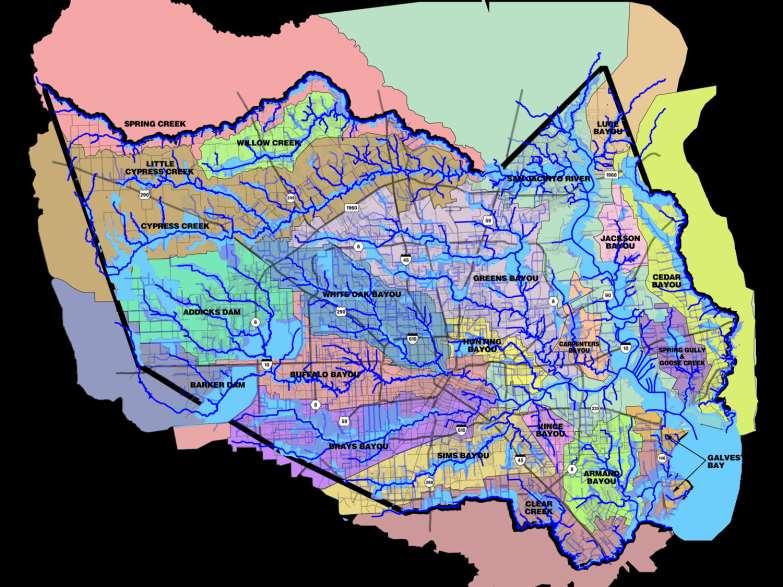

6 Floodplain Map
7 Harris County Flood Control District A special purpose district created in 1937 by the Texas legislature in response to floods that devastated the Houston-area in 1929 and 1935 Serves as a local partner to leverage federal tax dollars for flood damage reduction Harris County where we are Flood Control what we do District who we are Harris County Commissioners Court serves as our board of directors or governing body

8 OUR MISSION Provide flood damage reduction projects that work, with appropriate regard for community and natural values.


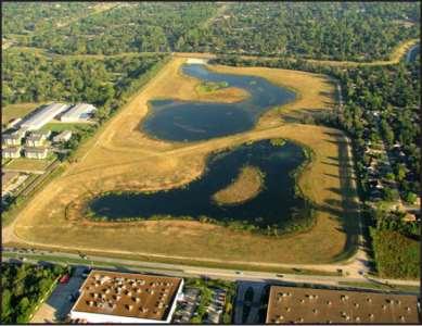
9 Flood Damage Reduction Tools Widen and deepen bayous and creeks Flood Damage Reduction Tools Relocate residents out of the floodplain Excavate large stormwater detention basins


10 Rain Events of PM 10 PM
11 May 2015 Rainfall Ten Wettest Months in Texas History (1895-Present) May 2015 June 2004 May 1914 September 1936 May 1929 May 1935 September 1974 October 1919 April 1957 November Rainfall (in) May 2015 wettest month ever since Surpassed previous record by 2.27 inches! May 2015 rainfall = 35 trillion gallons across TX!


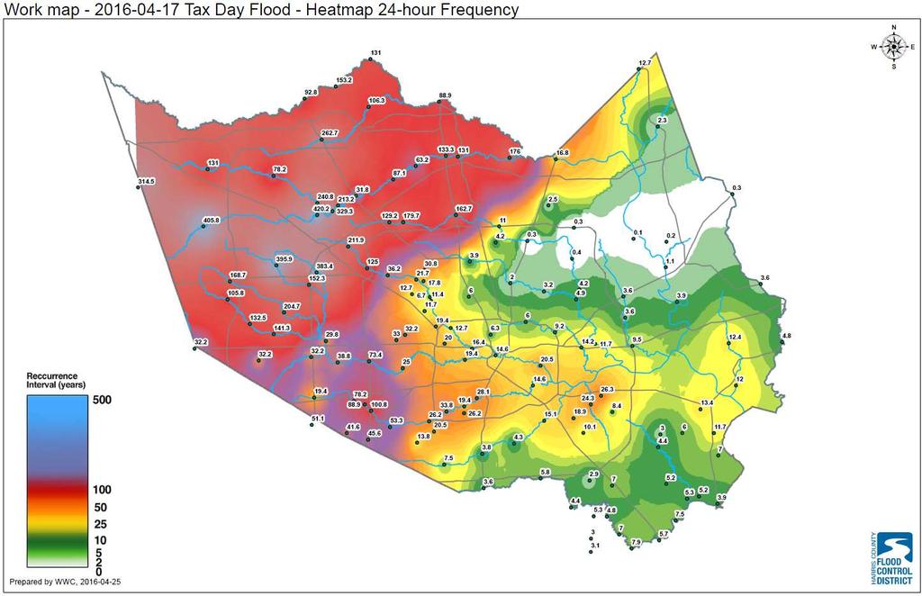
12 Rainfall Heat Maps


13 White Oak Bayou Memorial Day Event I-45 & N. Main Heights Blvd

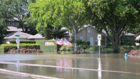
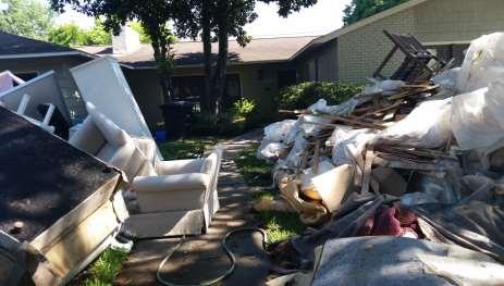
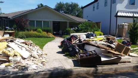
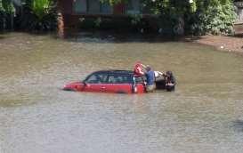
14 Property Damage
15 Rainfall Heat Maps

16 Concentrated House Flooding Areas Total flooded homes likely between 3000 and 6000
17 Losses Avoided Due to Buyouts
18
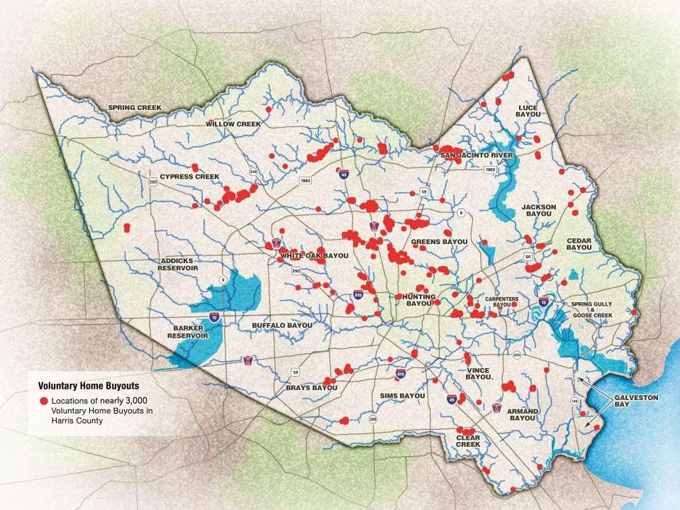
19 Voluntary Buyouts Millions spent on voluntary buyouts $207M for over 2,000 structures via FEMA grants 75% Federal Share More than 900 other properties purchased with District funds
20 Data and Tools Utilized Most Up-To Date HEC-RAS Models (FEMA Effective or newer) Structural Inventory Database Stream Gage Network (HCFCD Flood Warning System)
 floodplain for studied streams in the County Data is stored in a shapefile FF Elev.")
21 Structural Inventory Database Structures inside the 0.2% (500-year) floodplain for studied streams in the County Data is stored in a shapefile FF Elev. River Station WSELs Economic Damage Estimate Buyout Status

22 Stream Gage Network 133 Gages along HC creeks, bayous and tributaries Sensors transmit rainfall depths and water levels in real time Data publicly available ww.harriscountyfws.org

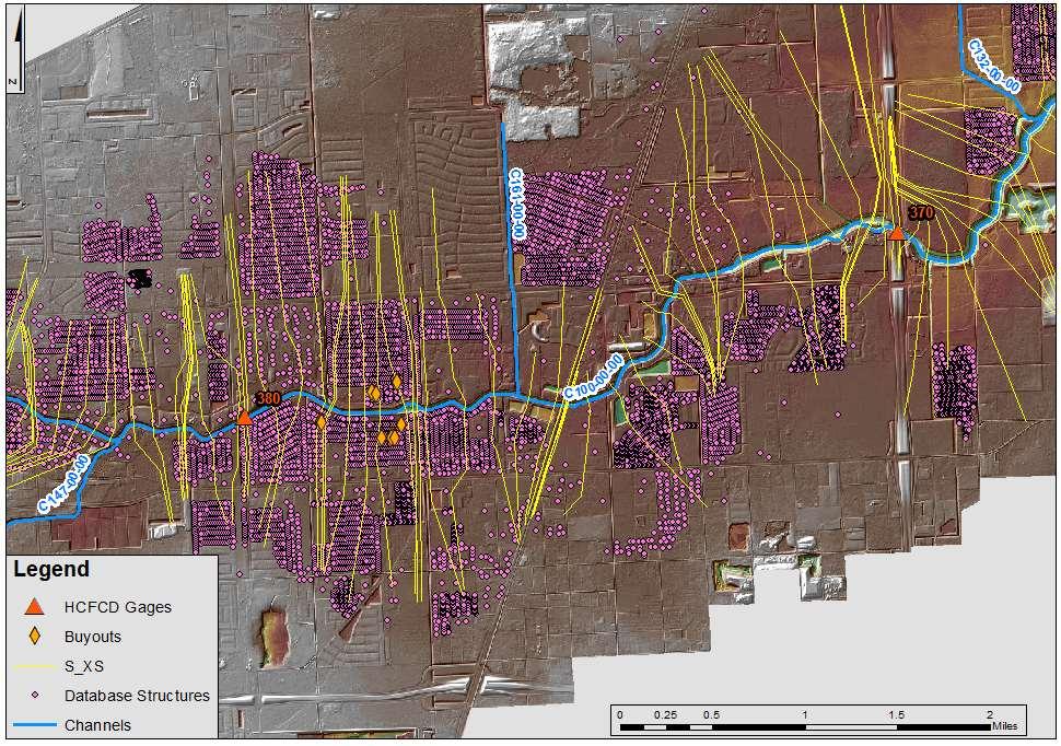
23 GIS Data

24 Event WSEL Profiles
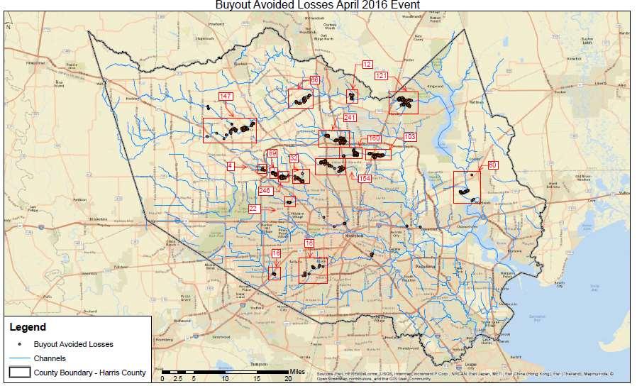
25 Buyout Avoided Damages Profile

26 Avoided Damages Due to Buyouts Memorial Day 2015 Flood Event
27 Result Highlights
28 Flood Reduction Projects
29 Rainfall Heat Maps

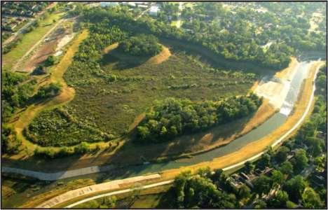
30 Sims Bayou Project 19.3 miles of Channel Improvement 3 Regional Detention Basin 22 Bridge Replacement Federal Cost to Date $263M HCFCD Cost to Date $129M

31 Sims Bayou Project

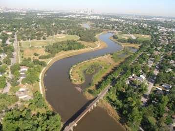
32 White Oak Bayou Project 15.3 miles of Channel Improvement 4 Regional Detention Basin 12 miles of park/trail Replacement Federal Cost to Date $70M HCFCD Cost to Date $54M


33 White Oak Bayou Project Jones Rd Fairbanks-N. Houston W. Little York Hollister Rd.

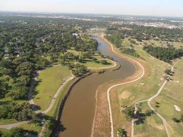
34 Project Brays 21.2 miles of Channel Improvement 4 Regional Detention Basin 30 Bridge Replacement Federal Cost to Date $167M HCFCD Cost to Date $141M


35 Eldridge Project Brays Mike Driscoll Park/ Old Westheimer Arthur Storey Park Willow Waterhole

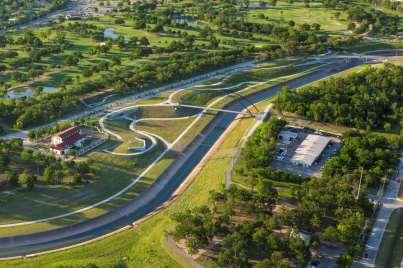
36 Project Brays

37 Over 11 Astrodomes of New Detention New Channel Conveyance Longer than Loop 610


38 State Hwy 288 Brays Bayou Channels Holcombe Chimney Rock South Rice


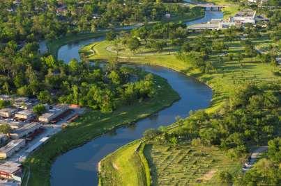
39 Brays Bayou Memorial Day Event Eldridge looking east Arthur Storey Park looking south Mike Driscoll Park/ Old Westheimer looking north
40 Losses Avoided Due to Projects
41 Available Data Gage Rainfall (HCFWS) Stream Water Surface Elevations Surveyed High Water Marks FEMA Effective Models and Profiles Updated Models and Profiles foot LiDAR Building Footprints with FF Elev. Rainfall Heat Maps
42 Modeling Method I Approximate Method Gaged Floodplain VS Effective Combination Floodplain Constructed components of Project are indirectly included in the analysis for the Gaged Floodplain
43 Modeling Method II HWM Floodplain VS Modeled Event Floodplain Used over 40 surveyed HWM HWM Floodplain was field-verified May 25th Rainfall was modeled in HEC-HMS and HEC-RAS using effective models to estimate potential flood damage pre-project Brays


44 Gage Rainfall
45 Radar Rainfall NEXRAD Digital Precipitation Array (DPA) One-hour increments May 25 11:00 PM to May 26 2:00 PM Standard reflectivity-rainfall relationship 1.4 Z = 300R radar Calibration of radar data based on trend between radar reflectivity values and hourly rainfall totals at each gauge 1.3 Z = 249R radar
46 Radar Rainfall

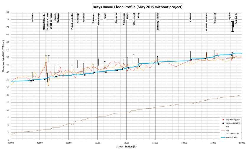
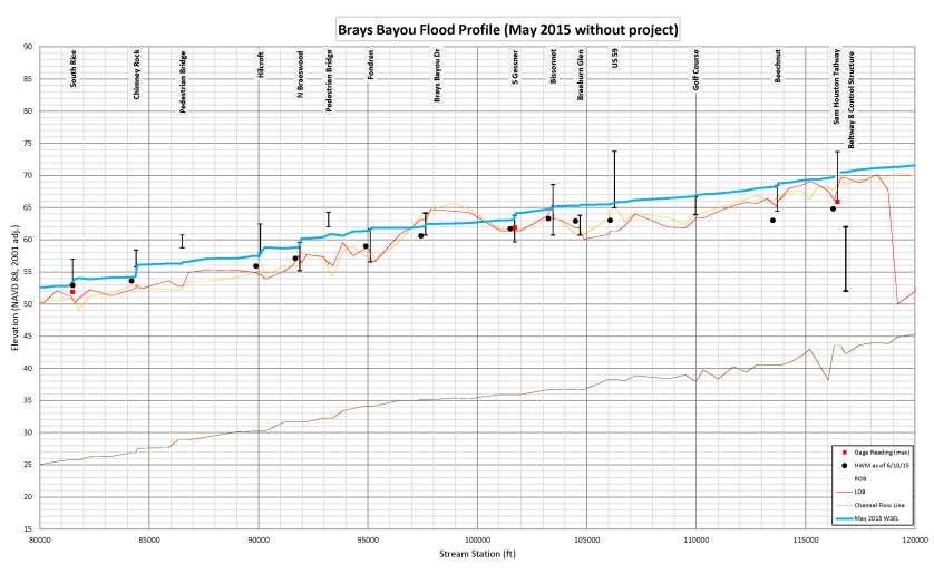
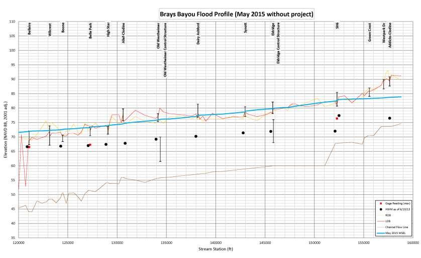
47 Method II Stream Profiles

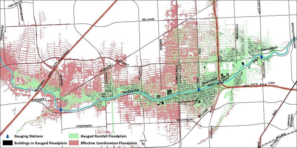
48 Method I Results

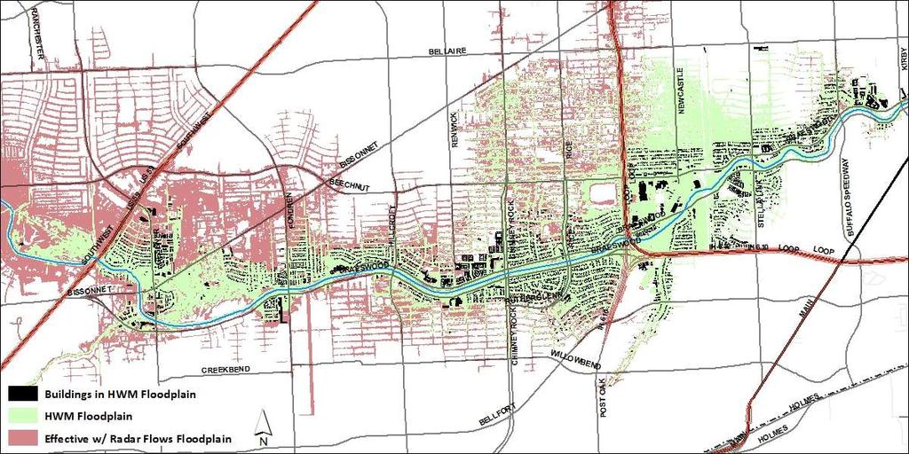
49 Method II Results

50 Sims Bayou Results

51 White Oak Bayou Results

52 White Oak Bayou Results


53 Avoided Damages Due to Projects May 25 October 25 October 31 Brays Bayou 7, Sims Bayou 1, ,700 White Oak Bayou 1,


54 April Radar 1 st Round 7 pm to 1 am 11 pm 2 nd Round 1 am to 8 am 3 am
55 Highest Rainfall Measured 5 min 1.0 Cypress Crk at SH min 2.2 Greens Bayou at North Belt 30 min 3.6 Cypress Crk at SH hour 4.7 Greens Bayou at Knobcrest 2 hour 7.3 Langham Crk at Longenbaugh 3 hour 8.3 Little Mound Crk at Mathis Rd 6 hour 13.9 Little Mound Crk at Mathis Rd 12 hour 16.7 Little Mound Crk at Mathis Rd 24 hour 17.4 Little Mound Crk at Mathis Rd 23.5 in 14.5 hours in Pattison, Waller County
56 Rainfall Comparison Recent Flood Events Date 1-hr 3-hr 6-hr 12-hr 24-hr 6/8/01 (Allison) /18/ /26/15 (Memorial Day) /18/16 (Tax Day)
57 3 Largest Rainfalls in 37 Years July 1979 (TS Claudette): 43.0 inches (24-hrs) US 24-hr rainfall record Alvin (Brazoria County) June 2001 (TS Allison): 28.5 inches (12-hrs) Greens Bayou (NE Harris County) Tax Day 2016: 23.5 inches (12-hrs) S Waller County Harris County PMP vs. Historic Events Rainfall Duration hr N/A 74% 61% hr 91% N/A N/A

58 12 Hr Peak Rainfall Isohyetals, Affected Areas

59 12 Hour Peak Rainfall Frequency


60 Cypress Creek Record flood levels set at six bridges. 11 bridges closed; 3 open between I-45 & US 290 Barker Cypress Huffmeister Grant Champions Forest

61 Preliminary House Flooding Locations ~60% flooded structures within 1% floodplain
62 FEMA Partnered Home Buyouts That Would Have Flooded 505 Greens Bayou 400 White Oak Bayou 220 Cypress Creek 180 San Jacinto River 150 Halls Bayou 35 Brays Bayou 10 Other Watersheds ~ 1,500 ~2,830 home buyouts in these watersheds since 1989
63
64

65 DRAFT EDIT

66 DRAFT EDIT

67 QUESTIONS???? Reduce the risk and rediscover the beauty
Hurricane Harvey. Jeff Lindner. Meteorologist Harris County Flood Control District
 Hurricane Harvey Jeff Lindner Meteorologist Harris County Flood Control District Addicks and Barker Watersheds Hurricane Harvey Track A Category 4 Hurricane With Epic Flood Forecasts had to separate the
Update to Lake Houston Area Grassroots Flood Prevention Initiative
 Update to Lake Houston Area Grassroots Flood Prevention Initiative Kaaren Cambio April 17, 2018 Where were you when Harvey came? Harvey Average of 33 of rain in 4 days across Harris County. 120,000 structures
MEMORANDUM. Director of Hydrologic Operations/Meteorologist
 MEMORANDM DATE: June 4, 2018 TO: FROM: RE: HCFCD Flood Watch/Partners Jeff Lindner Director of Hydrologic Operations/Meteorologist Steve Fitzgerald Chief Engineer Immediate Report Final Hurricane Harvey
Las Colonias Subdivision September 2010 Flood Study
 Las Colonias Subdivision September 2010 Flood Study Curtis Beitel, P.E., CFM Scott Muchard, P.E. Project Engineer William Badini, CFM Senior Meteorologist Location Map Background Los Colonias Subdivision
 Red River Flooding June 2015 Caddo and Bossier Parishes Presented by: Flood Technical Committee Where the Rain Falls Matters I-30 versus I-20 I-20 Backwater and Tributary Floods (Localized) 2016 Flood
San Antonio River Authority. San Antonio River Authority Floodworks implementation in the San Antonio River Basin. Nefi Garza, PE, CFM
 San Antonio River Authority Floodworks implementation in the San Antonio River Basin Nefi Garza, PE, CFM San Antonio River Authority Michael Crenshaw, PE, CFM Anthony J. Henry Wallingford Software, Inc
USGS Flood Inundation Mapping of the Suncook River in Chichester, Epsom, Pembroke and Allenstown, New Hampshire
 USGS Flood Inundation Mapping of the Suncook River in Chichester, Epsom, Pembroke and Allenstown, New Hampshire NH Water & Watershed Conference Robert Flynn, USGS NH-VT Water Science Center March 23, 2012
Leon Creek Watershed October 17-18, 1998 Rainfall Analysis Examination of USGS Gauge Helotes Creek at Helotes, Texas
 Leon Creek Watershed October 17-18, 1998 Rainfall Analysis Examination of USGS Gauge 8181400 Helotes Creek at Helotes, Texas Terrance Jackson MSCE Candidate University of Texas San Antonio Abstract The
YELLOWSTONE RIVER FLOOD STUDY REPORT TEXT
 YELLOWSTONE RIVER FLOOD STUDY REPORT TEXT TECHNICAL REPORT Prepared for: City of Livingston 411 East Callender Livingston, MT 59047 Prepared by: Clear Creek Hydrology, Inc. 1627 West Main Street, #294
Red River Levee Panel
 Red River Levee Panel Mississippi River Commission Monday, August 9, 2017 Red River Levees in LA & AR NONE along TX & OK Boarder Red River Levee Issues Caddo Levee Cherokee Park Authorization Bossier Levee
Out with the Old, In with the New: Implementing the Results of the Iowa Rapid Floodplain Modeling Project
 Out with the Old, In with the New: Implementing the Results of the Iowa Rapid Floodplain Modeling Project Traci Tylski, E.I., CFM Hydraulics Engineer USACE - Omaha District Traci.M.Tylski@USACE.army.mil
Risk Identification using Hazus
 Risk Identification using Hazus City of Boston, Suffolk County, MA Dave Shortman, GISP, CFM 6/21/2016 Agenda Objective Project Location Hazus Overview Hazus Level 2 Risk Assessment Comparison and Reporting
A Cloud-Based Flood Warning System For Forecasting Impacts to Transportation Infrastructure Systems
 A Cloud-Based Flood Warning System For Forecasting Impacts to Transportation Infrastructure Systems Jon Goodall Associate Professor, Civil and Environmental Engineering Associate Director, Link Lab April
HAZUS-MH: A Predictable Hurricane Risk Assessment Tool for the City of Houston and Harris County
 HAZUS-MH: A Predictable Hurricane Risk Assessment Tool for the City of Houston and Harris County Presented by Melvin G. Spinks, P.E., President Annie Ding, PhD, GISP October 29, 2008 Rice University Contents
Pequabuck River Flooding Study and Flood Mitigation Plan The City of Bristol and Towns of Plainville and Plymouth, CT
 Pequabuck River Flooding Study and Flood Mitigation Plan The City of Bristol and Towns of Plainville and Plymouth, CT Raymond Rogozinski and Maged Aboelata The City of Bristol and Towns of Plainville and
ARMSTRONG COUNTY, PA
 ARMSTRONG COUNTY, PA Revised Preliminary DFIRM Mapping March 31, 2013 Kevin Donnelly, P.E., CFM GG3, Greenhorne & O Mara, Inc. Presentation Agenda Armstrong County DFIRM Overview - June 25, 2010 DFIRM
UPPER COSUMNES RIVER FLOOD MAPPING
 UPPER COSUMNES RIVER FLOOD MAPPING DRAFT BASIC DATA NARRATIVE FLOOD INSURANCE STUDY SACRAMENTO COUTY, CALIFORNIA Community No. 060262 November 2008 Prepared By: CIVIL ENGINEERING SOLUTIONS, INC. 1325 Howe
Storm Surge Analysis Update Meeting Cross City, Florida June 17, 2014
 Big Bend Coastal Storm Surge Study Storm Surge Analysis Update Meeting Cross City, Florida June 17, 2014 Introductions Risk MAP Project Team FEMA Region IV Florida Division of Emergency Management (FDEM)
6/9/2014. Software Overview. System Overview
 Future Rainfall 6/9/2014 Curtis Beitel, PE, CFM, Anthony Henry and Wayne Tschirhart, PE, CFM, PMP TFMA Spring 2014 Conference Software Overview 2 Processes Hydrometric DB Event Manager Automatic Low =
Study 16.5 Probable Maximum Flood (PMF)
") Initial Study Report Meeting Study 16.5 Probable Maximum Flood (PMF) October 22, 2014 Prepared by 10/22/2014 1 Study 16.5 Objectives Develop a site-specific PMP to be used for the derivation of the PMF
Initial Study Report Meeting Study 16.5 Probable Maximum Flood (PMF) October 22, 2014 Prepared by 10/22/2014 1 Study 16.5 Objectives Develop a site-specific PMP to be used for the derivation of the PMF
Pompton Lakes Dam Downstream Effects of the Floodgate Facility. Joseph Ruggeri Brian Cahill Michael Mak Andy Bonner
 Pompton Lakes Dam Downstream Effects of the Joseph Ruggeri Brian Cahill Michael Mak Andy Bonner ASFPM 2013: Overview Page 2 Overview Page 3 Overview Page 4 Overview Page 5 Overview - Historical Pompton
Final Report. COMET Partner's Project. University of Texas at San Antonio
 Final Report COMET Partner's Project University: Name of University Researcher Preparing Report: University of Texas at San Antonio Dr. Hongjie Xie National Weather Service Office: Name of National Weather
Zone A Modeling (What Makes A Equal Approximate, Adequate, or Awesome)
") Zone A Modeling (What Makes A Equal Approximate, Adequate, or Awesome) ASFPM 2016 GRAND RAPIDS CONFERENCE Kevin Donnelly, P.E., GISP, PMP, CFM June 23, 2016 Agenda 1 Introduction 2 Flood Hazard Analysis
Zone A Modeling (What Makes A Equal Approximate, Adequate, or Awesome) ASFPM 2016 GRAND RAPIDS CONFERENCE Kevin Donnelly, P.E., GISP, PMP, CFM June 23, 2016 Agenda 1 Introduction 2 Flood Hazard Analysis
Base Level Engineering FEMA Region 6
 Base Level Engineering Over the past five years, has been evaluating its investment approach and data preparation work flow to establish an efficient and effective change in operation, generating an approach
ASFPM - Rapid Floodplain Mapping
 ASFPM - Nicole Cominoli Hydraulic Engineer USACE - Omaha District mary.n.cominoli@usace.army.mil June 3, 2015 US Army Corps of Engineers Mitigation = Risk Informed Decisions 2 The National Flood Insurance
Enhancing a Distributed Hydrologic Model: Addition of Storm Water Pipe Analysis within a GIS Framework in an Urban Area.
 Enhancing a Distributed Hydrologic Model: Addition of Storm Water Pipe Analysis within a GIS Framework in an Urban Area Zheng Fang Abstract The City of Houston has been facing flood problems of a serious
Rapid Flood Mapping Using Inundation Libraries
 Rapid Flood Mapping Using Inundation Libraries Jude Kastens, Kevin Dobbs, James Halgren, Katherine Balster 2017 ASFPM Conference May 3, 2017 5 mi Kansas River Valley between Manhattan and Topeka Email:
USING GIS TO MODEL AND ANALYZE HISTORICAL FLOODING OF THE GUADALUPE RIVER NEAR NEW BRAUNFELS, TEXAS
 USING GIS TO MODEL AND ANALYZE HISTORICAL FLOODING OF THE GUADALUPE RIVER NEAR NEW BRAUNFELS, TEXAS ASHLEY EVANS While the state of Texas is well-known for flooding, the Guadalupe River Basin is one of
Detailed Storm Rainfall Analysis for Hurricane Ivan Flooding in Georgia Using the Storm Precipitation Analysis System (SPAS) and NEXRAD Weather Radar
 and NEXRAD Weather Radar") Detailed Storm Rainfall Analysis for Hurricane Ivan Flooding in Georgia Using the Storm Precipitation Analysis System (SPAS) and NEXRAD Weather Radar Ed Tomlinson, PhD and Bill Kappel Applied Weather Associates
Detailed Storm Rainfall Analysis for Hurricane Ivan Flooding in Georgia Using the Storm Precipitation Analysis System (SPAS) and NEXRAD Weather Radar Ed Tomlinson, PhD and Bill Kappel Applied Weather Associates
GREENE COUNTY, PA. Revised Preliminary DFIRM Mapping FEMA. Kevin Donnelly, P.E., CFM GG3, Greenhorne & O Mara, Inc. April 10, 2013
 GREENE COUNTY, PA Revised Preliminary DFIRM Mapping April 10, 2013 Kevin Donnelly, P.E., CFM GG3, Greenhorne & O Mara, Inc. Presentation Agenda Greene County DFIRM Overview September 30, 2010 DFIRM Countywide
Village of Glenview: Community-wide Flood Risk Reduction Program (FRRP)
") Village of Glenview: Community-wide Flood Risk Reduction Program (FRRP) Sarah Pasquesi, P.E. Project Engineer AECOM sarah.pasquesi@aecom.com Shane Schneider, P.E. Village Engineer Village of Glenview shanes@glenview.il.us
Village of Glenview: Community-wide Flood Risk Reduction Program (FRRP) Sarah Pasquesi, P.E. Project Engineer AECOM sarah.pasquesi@aecom.com Shane Schneider, P.E. Village Engineer Village of Glenview shanes@glenview.il.us
9. PROBABLE MAXIMUM PRECIPITATION AND PROBABLE MAXIMUM FLOOD
 9. PROBABLE MAXIMUM PRECIPITATION AND PROBABLE MAXIMUM FLOOD 9.1. Introduction Due to the size of Watana Dam and the economic importance of the Project to the Railbelt, the Probable Maximum Flood (PMF)
Hurricane Harvey Flood Emergency Response
 Hot Science - Cool Talk # 114 Hurricane Harvey Flood Emergency Response Dr. David Maidment September 14, 2018 Produced by and for Hot Science - Cool Talks by the Environmental Science Institute. We request
PENNSYLVANIA DEPARTMENT OF TRANSPORTATION ENGINEERING DISTRICT 3-0
 PENNSYLVANIA DEPARTMENT OF TRANSPORTATION ENGINEERING DISTRICT 3-0 LYCOMING COUNTY S.R.15, SECTION C41 FINAL HYDROLOGIC AND HYDRAULIC REPORT STEAM VALLEY RUN STREAM RELOCATION DATE: June, 2006 REVISED:
Real-Time Flood Forecasting Modeling in Nashville, TN utilizing HEC-RTS
 Real-Time Flood Forecasting Modeling in Nashville, TN utilizing HEC-RTS Brantley Thames, P.E. Hydraulic Engineer, Water Resources Section Nashville District, USACE August 24, 2017 US Army Corps of Engineers
New Mapping, Recent Events What do we know? June 9, 2011
 New Mapping, Recent Events What do we know? June 9, 2011 e FEMA Mapping Process Current Flood Insurance Rate Maps (FIRMs) or Floodplain Maps date back to the early 1970 s. The District contracted with
LOCATED IN INDIAN RIVER COUNTY PREPARED FOR S.J.R.W.M.D. AND F.W.C.D. DECEMBER, 2003 Updated 2007 Updated May 2014 PREPARED BY
 FELLSMERE WATER CONTROL DISTRICT EAST MASTER DRAINAGE PLAN AND STORMWATER HYDROLOGIC ANALYSIS OF THE GRAVITY DRAINAGE SYSTEM LOCATED BETWEEN THE EAST BOUNDARY, LATERAL U, THE MAIN CANAL, AND DITCH 24 LOCATED
APRIL 28, The University of Texas MD Anderson Cancer Center. Houston, Texas PRESENTED BY 2017 EHSSENTIALS
 APRIL 28, 2017 The University of Texas MD Anderson Cancer Center Houston, Texas PRESENTED BY The RICE/TMC Flood Alert System: Data-Driven Emergency Management Decision Making Bryan Evans Manager, Risk
Chapter 5 CALIBRATION AND VERIFICATION
 Chapter 5 CALIBRATION AND VERIFICATION This chapter contains the calibration procedure and data used for the LSC existing conditions model. The goal of the calibration effort was to develop a hydraulic
VILLAGE COUNCIL STORMWATER REPORT JULY 23, 2016 STORM EVENT
 VILLAGE COUNCIL STORMWATER REPORT JULY 23, 2016 STORM EVENT STORM RAINFALL AND RADAR IMAGERY Total rainfall 4.99 inches 2.74 inches between 5:40 and 7:10, then a lull until 9:30 2.04 inches between 9:30
LOMR SUBMITTAL LOWER NESTUCCA RIVER TILLAMOOK COUNTY, OREGON
 LOMR SUBMITTAL LOWER NESTUCCA RIVER TILLAMOOK COUNTY, OREGON Prepared for: TILLAMOOK COUNTY DEPARTMENT OF COMMUNITY DEVELOPMENT 1510-B THIRD STREET TILLAMOOK, OR 97141 Prepared by: 10300 SW GREENBURG ROAD,
Floodplain Mapping & Flood Warning Applications in North Carolina
 Floodplain Mapping & Flood Warning Applications in North Carolina Marc Stanard, IT Project Manager Ken Ashe, Assistant Director David Herlong, Flood Warning Program Manager NC Crime Control & Public Safety
Floodplain Risk Management in Dungog after the April 2015 Super Storm. Presentation Outline
 Presentation Outline Floodplain Risk Management in after the April 2015 Super Storm Rohan Hudson, Royal HaskoningDHV FMA 2017 Preparing for the Next Great Flood 17th May 2017 Background and Flood Mechanisms
Tropical Storm Harvey: SE Texas Impacts. 10 AM CDT UPDATE Sunday August 27, 2017 Prepared by: Lance Wood
 Tropical Storm Harvey: SE Texas Impacts 10 AM CDT UPDATE Sunday August 27, 2017 Prepared by: Lance Wood Situation Overview Catastrophic flooding is ongoing with flash flood emergencies remaining in effect.
Hydrologic Engineering Applications of Geographic Information Systems
 Hydrologic Engineering Applications of Geographic Information Systems Davis, California Objectives: The participant will acquire practical knowledge and skills in the application of GIS technologies for
Technical Memorandum. City of Salem, Stormwater Management Design Standards. Project No:
 Technical Memorandum 6500 SW Macadam Avenue, Suite 200 Portland, Oregon, 97239 Tel: 503-244-7005 Fax: 503-244-9095 Prepared for: Project Title: City of Salem, Oregon City of Salem, Stormwater Management
Section 4: Model Development and Application
 Section 4: Model Development and Application The hydrologic model for the Wissahickon Act 167 study was built using GIS layers of land use, hydrologic soil groups, terrain and orthophotography. Within
Geolocation and Analysis of FEMA FIS Discharge Data
 Proud Platinum Sponsor of the ASFPM 2017 Annual Conference Geolocation and Analysis of FEMA FIS Discharge Data Jeff Smith, P.E., PMP, CFM William Jiang, P.E., CFM ASFPM 2017 Annual Conference FLOOD RISK
The Beleaguered Figure 15
 The Beleaguered Figure 15 TFMA 2015 Fall Technical Summit After the Floods: Texas Rising Craig Loftin, PE, CFM US Weather Bureau Technical Paper No. 40, Figure 15 Village Creek Watershed 1 100-Year 30-Minute
The Beleaguered Figure 15 TFMA 2015 Fall Technical Summit After the Floods: Texas Rising
 The Beleaguered Figure 15 TFMA 2015 Fall Technical Summit After the Floods: Texas Rising Craig Loftin, PE, CFM US Weather Bureau Technical Paper No. 40, Figure 15 Village Creek Watershed 100-Year 30-Minute
LOMR SUBMITTAL LOWER NEHALEM RIVER TILLAMOOK COUNTY, OREGON
 LOMR SUBMITTAL LOWER NEHALEM RIVER TILLAMOOK COUNTY, OREGON Prepared for: TILLAMOOK COUNTY DEPARTMENT OF COMMUNITY DEVELOPMENT 1510-B THIRD STREET TILLAMOOK, OR 97141 Prepared by: 10300 SW GREENBURG ROAD,
Areal Reduction Factors for the Colorado Front Range and Analysis of the September 2013 Colorado Storm
 Areal Reduction Factors for the Colorado Front Range and Analysis of the September 2013 Colorado Storm Doug Hultstrand, Bill Kappel, Geoff Muhlestein Applied Weather Associates, LLC - Monument, Colorado
Memo. I. Executive Summary. II. ALERT Data Source. III. General System-Wide Reporting Summary. Date: January 26, 2009 To: From: Subject:
 Memo Date: January 26, 2009 To: From: Subject: Kevin Stewart Markus Ritsch 2010 Annual Legacy ALERT Data Analysis Summary Report I. Executive Summary The Urban Drainage and Flood Control District (District)
RAINFALL FREQUENCY ANALYSIS FOR NEW BRAUNFELS, TX (or Seems like we ve been having lots of 100-yr storms)
") RAINFALL FREQUENCY ANALYSIS FOR NEW BRAUNFELS, TX (or Seems like we ve been having lots of 100-yr storms) Presented By: SAUL NUCCITELLI, PE, CFM (LAN) BLAKE KRONKOSKY, EIT (LAN) JIM KLEIN, PE (CITY OF
RAINFALL FREQUENCY ANALYSIS FOR NEW BRAUNFELS, TX (or Seems like we ve been having lots of 100-yr storms) Presented By: SAUL NUCCITELLI, PE, CFM (LAN) BLAKE KRONKOSKY, EIT (LAN) JIM KLEIN, PE (CITY OF
SSPEED Center Tropical Storm Harvey Summary Report No. 1. September 5, 2017
 SSPEED Center Tropical Storm Harvey Summary Report No. 1 September 5, 2017 Tropical Storm Harvey Summary Report No. 1 September 5, 2017 By Philip Bedient, Jim Blackburn, Avantika Gori, and Andrew Juan
Bank Erosion and Morphology of the Kaskaskia River
 Bank Erosion and Morphology of the Kaskaskia River US Army Corps Of Engineers St. Louis District Fayette County Soil and Water Conservation District Team Partners : Carlyle Lake Ecosystem Partnership Vicinity
MEMORANDUM. Situation. David Ford Consulting Engineers, Inc J Street, Suite 200 Sacramento, CA Ph Fx
 David Ford Consulting Engineers, Inc. 2015 J Street, Suite 200 Sacramento, CA 95811 Ph. 916.447.8779 Fx. 916.447.8780 MEMORANDUM To: Brad Moore, PE, USACE From: Nathan Pingel, PE (Lic # CA 63242), and
Study 16.5 Probable Maximum Flood (PMF)
") Initial Study Report Meeting Study 16.5 Probable Maximum Flood (PMF) March 30, 2016 Prepared by 3/30/2016 1 Study 16.5 Status ISR documents (ISR Part D Overview): Status: Initial Study Report: Parts A,
Initial Study Report Meeting Study 16.5 Probable Maximum Flood (PMF) March 30, 2016 Prepared by 3/30/2016 1 Study 16.5 Status ISR documents (ISR Part D Overview): Status: Initial Study Report: Parts A,
Areal Reduction Factors for the Colorado Front Range and Analysis of the September 2013 Colorado Storm
 Areal Reduction Factors for the Colorado Front Range and Analysis of the September 2013 Colorado Storm Doug Hultstrand, Bill Kappel, Geoff Muhlestein Applied Weather Associates, LLC - Monument, Colorado
The NEXRAD Revolution: Scientific Basis for Updating the HMR-49 Statistical Storm Intensities and PMPs
 The NEXRAD Revolution: Scientific Basis for Updating the HMR-49 Statistical Storm Intensities and PMPs Bill Kappel, Senior Meteorologist/President Applied Weather Associates, Monument, CO www.appliedweatherassociates.com
Natural and Human Influences on Flood Zones in Wake County. Georgia Ditmore
 Natural and Human Influences on Flood Zones in Wake County Georgia Ditmore Prepared for GEOG 591 December 5, 2014 2 Table of Contents Introduction.3 Objectives...5 Methods...6 Conclusion.11 References
Presented by Jerry A. Gomez, P.E. National Hydropower Association Northeast Regional Meeting - September 17, 2009
 Presented by Jerry A. Gomez, P.E. National Hydropower Association Northeast Regional Meeting - September 17, 2009 Defining Probable Maximum Precipitation (PMP) PMP is the theoretically greatest depth of
COLORING PAGES. Follow Raindy the Raindrop as he travels from your house out to sea.
 COLORING PAGES www.hcfcd.org Follow Raindy the Raindrop as he travels from your house out to sea. Raindy the Raindrop falls from the sky and lands on your house or in your neighborhood. Once he s on the
Flood Insurance Study
 Flood Insurance Study Grant County, Arkansas Status Meeting November 17, 2010, 2pm Grant County OES/EOC 130 Grant 74, Sheridan, AR 72150 1 Presentation Overview Introduction FEMA Risk MAP Update Study
TFMA Spring Conference Houston, Texas March 10, 2016 PROJECT TEAM:
 TFMA Spring Conference Houston, Texas March 10, 2016 PROJECT TEAM: Brown, Leal & Associates R. Gutierrez Engineering ERO Architects Administered by the Texas Water Development Board History of the Study
HEC & GIS Modeling of the Brushy Creek HEC & GIS Watershed Modeling of the
 HEC & GIS Modeling of the Brushy Creek HEC & GIS Watershed Modeling of the By Cassandra Fagan 5, December 2014 http://ubcwatershedstudy.ursokr.com/images/ Contents Introduction... 3 Figure 1: 24-hour rainfall
September 20, 2012 TFMA 2012 Fall Conference, Rockwall, Texas
 September 20, 2012 TFMA 2012 Fall Conference, Rockwall, Texas Martha Juch, P.E., CFM, D.WRE Project Director, AECOM Served as President of Upper Brushy WCID Board during T.S. Hermine Melinda Luna, P.E.,
Local Flood Hazards. Click here for Real-time River Information
 Local Flood Hazards Floods of the White River and Killbuck Creek are caused by runoff from general, and/or intense rainfall. Other areas of flooding concern are from the Boland Ditch and Pittsford Ditch.
Southeastern Texas historic rain of 18 April 2016 by Richard H. Grumm and Charles Ross National Weather Service State College, PA 16803
 Southeastern Texas historic rain of 18 April 2016 by Richard H. Grumm and Charles Ross National Weather Service State College, PA 16803 1. Introduction Extremely heavy rainfall across southeastern Texas
Ground Water Protection Council 2017 Annual Forum Boston, Massachusetts. Ben Binder (303)
") Ground Water Protection Council 2017 Annual Forum Boston, Massachusetts Protecting Groundwater Sources from Flood Borne Contamination Ben Binder (303) 860-0600 Digital Design Group, Inc. The Problem Houston
Ground Water Protection Council 2017 Annual Forum Boston, Massachusetts Protecting Groundwater Sources from Flood Borne Contamination Ben Binder (303) 860-0600 Digital Design Group, Inc. The Problem Houston
Drought. Jeffrey Lindner Meteorologist Harris County Flood Control District September 20, 2011
 2010-2011 Drought Jeffrey Lindner Meteorologist Harris County Flood Control District September 20, 2011 Texas Annual Rainfall Texas Annual Rainfall 1895-2010 Texas Annual Temperature 1895-2010 Notice Any
White River Update. Jeanne Stypula, Supervising Engineer. Advisory Committee Meeting April 26, 2016
 White River Update Jeanne Stypula, Supervising Engineer Advisory Committee Meeting April 26, 2016 Department of Natural Resources and Parks Water and Land Resources Division River and Floodplain Management
Probable Maximum Precipitation Study
 Probable Maximum Precipitation Study Virginia Floodplain Management Association Workshop Thursday, October 29, 2015 Robert T. Bennett, PE, RA, CFM DCR Dam Safety & Floodplain Management Definition (4VAC50-20-50.H)
ICE IS THICKER THAN WATER GALENA, ALASKA. Taunnie Boothby, CFM State of Alaska NFIP Coordinator Alaska Division of Community and Regional Affairs
 ICE IS THICKER THAN WATER GALENA, ALASKA Taunnie Boothby, CFM State of Alaska NFIP Coordinator Alaska Division of Community and Regional Affairs 2014 ASFPM Conference Seattle, WA June 1 6, 2014 Agenda
Flooding in Western North Carolina: Some Spatial, Hydrologic, and Seasonal Characteristics CAUTION!! Outline. Basic Flood Facts.
 Flooding in Western North Carolina: Some Spatial, Hydrologic, and Seasonal Characteristics J. Greg Dobson CAUTION!! National Environmental Modeling and Analysis Center RENCI at UNC-Asheville Engagement
Suwannee Satilla Basins Flood Control Issues, Opportunities and Assistance
 Suwannee Satilla Basins Flood Control Issues, Opportunities and Assistance Georgia Silver Jackets Meeting Valdosta, GA April 11, 2013 Presentation Outline Basin overview Recent floods: 2009 100 year flood
Results of Intensity-Duration- Frequency Analysis for Precipitation and Runoff under Changing Climate
 Results of Intensity-Duration- Frequency Analysis for Precipitation and Runoff under Changing Climate Supporting Casco Bay Region Climate Change Adaptation RRAP Eugene Yan, Alissa Jared, Julia Pierce,
Rainwater Harvesting in Austin, TX Sarah Keithley University of Texas at Austin
 Rainwater Harvesting in Austin, TX Sarah Keithley University of Texas at Austin 1 Abstract Rainwater harvesting, the collection of rainwater from a roof catchment, is an alternative water resource and
Leveraging new models and data to improve flood stage forecast. Improving Flood Stage Forecasting in the Feather River Watershed. September 11 th 2015
 Leveraging new models and data to improve flood stage forecast Improving Flood Stage Forecasting in the Feather River Watershed September 11 th 2015 Mitch Russo, P.E. (DWR) Ashok Bathulla, P.E., CFM (GEI)
Billion Dollar U.S. Flood Disasters in 2016
 Billion Dollar U.S. Flood Disasters in 2016 ArkLaMiss, Mar. 16 Houston, Apr. 16 WV, June 16 LA, Aug. 16 Matthew, Oct. 16 Greg Carbin Chief, Forecast Operations Branch NCEP/Weather Prediction Center College
RISK ASSESSMENT COMMUNITY PROFILE NATURAL HAZARDS COMMUNITY RISK PROFILES. Page 13 of 524
 RISK ASSESSMENT COMMUNITY PROFILE NATURAL HAZARDS COMMUNITY RISK PROFILES Page 13 of 524 Introduction The Risk Assessment identifies and characterizes Tillamook County s natural hazards and describes how
Speakers: NWS Buffalo Dan Kelly and Sarah Jamison, NERFC Jeane Wallace. NWS Flood Services for the Black River Basin
 Speakers: NWS Buffalo Dan Kelly and Sarah Jamison, NERFC Jeane Wallace NWS Flood Services for the Black River Basin National Weather Service Who We Are The National Oceanic and Atmospheric Administration
Flood Hazard Inundation Mapping. Presentation. Flood Hazard Mapping
 Flood Hazard Inundation Mapping Verne Schneider, James Verdin, and JeradBales U.S. Geological Survey Reston, VA Presentation Flood Hazard Mapping Requirements Practice in the United States Real Time Inundation
USGS Hydrography Overview. May 9, 2018
 + 1 USGS Hydrography Overview May 9, 2018 + 2 The National Geospatial Program Provides the geospatial baseline of the Nation s topography, natural landscape and built environment through The National Map,
NWS Mission 5/25/2017. Innovations in Flood Forecasting at the National Weather Service West Gulf River Forecast Center
 Innovations in Flood Forecasting at the National Weather Service West Gulf River Forecast Center Kris Lander, PE, CFM Gregory Waller NWS West Gulf River Forecast Center NWS Mission To provide weather,
Hydrologic Evaluation of the Blanchard River
 Hydrologic Evaluation of the Blanchard River Hancock County Flood Risk Reduction Program Prepared for: Maumee Watershed Conservancy District 1464 Pinehurst Dr. Defiance, Ohio 43512 Prepared by: Stantec
ARTICLE 5 (PART 2) DETENTION VOLUME EXAMPLE PROBLEMS
 DETENTION VOLUME EXAMPLE PROBLEMS") ARTICLE 5 (PART 2) DETENTION VOLUME EXAMPLE PROBLEMS Example 5.7 Simple (Detention Nomograph) Example 5.8 Offsite and Unrestricted Areas (HEC-HMS) Example 5.9 Ponds in Series w/ Tailwater (HEC-HMS) Example
ARTICLE 5 (PART 2) DETENTION VOLUME EXAMPLE PROBLEMS Example 5.7 Simple (Detention Nomograph) Example 5.8 Offsite and Unrestricted Areas (HEC-HMS) Example 5.9 Ponds in Series w/ Tailwater (HEC-HMS) Example
An Overview of Operations at the West Gulf River Forecast Center Gregory Waller Service Coordination Hydrologist NWS - West Gulf River Forecast Center
 National Weather Service West Gulf River Forecast Center An Overview of Operations at the West Gulf River Forecast Center Gregory Waller Service Coordination Hydrologist NWS - West Gulf River Forecast
Severe Weather Potential for Southeast Texas
 Severe Weather Potential for Southeast Texas Dan Reilly, Kent Prochazka, Scott Overpeck National Weather Service Houston/Galveston 10 am Synopsis Storm to likely bring severe weather to Southeast Texas
President s Day Weekend Storm Community Meeting and Workshop April 17, 2017
 President s Day Weekend Storm Community Meeting and Workshop April 17, 2017 Meeting outline 1. Progress update on the City of San Jose s recovery efforts 2. Water district presentation on: Weather situation
Riverine Modeling Proof of Concept
 Technical Team Meeting Riverine Modeling Proof of Concept Version 2 HEC-RAS Open-water Flow Routing Model April 15-17, 2014 Prepared by R2 Resource Consultants, Brailey Hydrologic, Geovera, Tetra Tech,
Nebraska. Large Area Mapping Initiative. The Nebraska. Introduction. Nebraska Department of Natural Resources
 Nebraska Department of Natural Resources Introduction The Nebraska The Nebraska Department of Natural Resources (NDNR) has developed a process for using a geographic information system (GIS) to map Approximate
Doug Kluck NOAA Kansas City, MO National Center for Environmental Information (NCEI) National Integrated Drought Information System (NIDIS)
 National Integrated Drought Information System (NIDIS)") National Integrated Drought Information System (NIDIS) for the Missouri River Basin Drought Early Warning Information System (DEWS) & Runoff Trends in the Missouri Basin & Latest Flood Outlook Doug Kluck
National Integrated Drought Information System (NIDIS) for the Missouri River Basin Drought Early Warning Information System (DEWS) & Runoff Trends in the Missouri Basin & Latest Flood Outlook Doug Kluck
APPENDIX 3B OCCURRENCE OF SIGNIFICANT RIVER ALLUVIUM AQUIFERS IN THE PLATEAU REGION
 Plateau Region Water Plan January 2011 APPENDIX 3B OCCURRENCE OF SIGNIFICANT RIVER ALLUVIUM AQUIFERS IN THE PLATEAU REGION Occurrence of Significant River Alluvium Aquifers in the Plateau Region Prepared
Rucker Pond. Background
 Rucker Pond Background The Rucker Basin consists of two subbasins (East and West) that drain to a single area known as Rucker Pond. Both subbasins have the same hydraulic parameters, but have different
GIS Techniques for Floodplain Delineation. Dean Djokic
 GIS Techniques for Floodplain Delineation Dean Djokic (ddjokic@esri.com) Content What is a floodplain? How to get a floodplain? What can GIS do for floodplain modeling? Simple GIS techniques for floodplain
Corps Involvement in FEMA s Map Modernization Program
 HH&C Tri-Service Infrastructure Conference 2-5 August 2005 - St. Louis Corps Involvement in FEMA s Map Modernization Program Kate White, PhD, PE (CEERD-RN) John Hunter, PE (CELRN) Mark Flick (CELRN) FEMA
Background and Purpose of Meeting. River Towers Meeting. Flood Risk Management Study Alternatives Overview
 1 and Purpose of Meeting River Towers Meeting Flood Risk Management Study Alternatives Overview September 23, 2014 There is no "proposed" flood risk management solution for this area at this time Fairfax
Roger Andy Gaines, Research Civil Engineer, PhD, P.E.
 Roger Andy Gaines, Research Civil Engineer, PhD, P.E. Research Civil Engineer/Regional Technical Specialist Memphis District August 24, 2010 Objectives Where we have been (recap of situation and what s
Issue 44: Phase II & III H&H Issues Date: 07/03/2006 Page 1
 Background Phase I of the NCFMP studies have primarily focused on the coastal plain and sandhills physiographic regions in of the State. Phase II and III study areas will focus on the piedmont, foothills,