September 20, 2012 TFMA 2012 Fall Conference, Rockwall, Texas
|
|
|
- Phoebe Scott
- 6 years ago
- Views:
Transcription


1 September 20, 2012 TFMA 2012 Fall Conference, Rockwall, Texas


2 Martha Juch, P.E., CFM, D.WRE Project Director, AECOM Served as President of Upper Brushy WCID Board during T.S. Hermine Melinda Luna, P.E., CFM Team Lead, Floodplain Mapping Services TWDB/TNRIS
3 Two Year Anniversary of T.S. Hermine in Williamson County, Texas Brief Overview Review of process to request Disaster Declaration Damages sustained by communities Note: Presentation is a follow-up to TFMA Fall 2010 presentation by Martha Juch and Jay Scanlon, with many of the graphics/data from that presentation included

4 Tropical Storm Hermine September 7-9, 2010 Storm track through Texas, Oklahoma, Kansas, and Missouri Provided by Williamson County Emergency Management, July 2012

5 Tropical Storm Hermine September 7-8, 2010 Weather Underground Williamson County Rainfall Data Source: Williamson County Engineer, Sep. 2010

6 Tropical Storm Hermine September 7-8, 2010 NWS Radar Williamson County Rainfall Estimates

7 Tropical Storm Hermine September 7-8, 2010 NWS Radar Upper Brushy Creek Watershed Rainfall Estimates
8 Tropical Storm Hermine September 7-8, 2010 San Gabriel Unofficial Rainfall Data Extreme Rainfall inches in 26 hrs Bucket surveys inches

9 Tropical Storm Hermine September 7-8, 2010 Bucket Surveys North Georgetown Source: Williamson County Engineer, Sep. 2010

10 Tropical Storm Hermine September 7-8, 2010 Upper Brushy Creek Watershed Rainfall Data from UBC WCID gages at dams Sep. 2010
11 Tropical Storm Hermine September 7-8, 2010 UBC WCID Rainfall Data Rainfall Intensity Rainfall Total (inches) (inches/hr) Dam 1 hr 2 hr 3 hr 6 hr 12 hr 24 hr 1/4 Hr 1 hr MAX Sep. 2010
12 Tropical Storm Hermine September 7-8, 2010 Depth-Duration Frequency of Precipitation Storm Event (Return Period) Non-Exceedance Probability 2 50% 5 20% 10 10% 25 4% 50 2% 100 1% % % 100% PMF - Storm Duration (hours) Values in the table represent regional parameters near the centroid of the District. Values will vary slightly across the District Sep. 2010
13 Lesson Learned: Keep repeating the message: although rare, this flood is not unique Extreme Rainfall June 27, 2007 Marble Falls 1919 Austin, Texas 1873 Red River County, Texas
14 Tropical Storm Hermine in Texas A Presidential Disaster Declaration was requested but denied: FEMA toured Williamson County, one of 43 counties affected by the flooding from Tropical Storm Hermine. Federal threshold of 800 homes or substantial damages of $26.5 million in uninsured damages is required. Williamson County had difficulty getting homeowners to report damages, so values are probably underestimated. They also believe some neighboring counties failed to report damages to FEMA, causing the reported damages to erroneously fall short of the threshold. Governor requested disaster declaration, it was denied, he appealed, and it was denied again The Small Business Administration issued a disaster declaration for 18 counties in November 2012 to provide loans up to $200,000 for homeowners and up to $2 million for business owners
15 Williamson County: Extensive Flooding occurred in Williamson County County emergency management initially reporting 630+ homes had some damage Residential Statistics: Final count of 687 homes damaged 32 Destroyed (>48 Water) 150 Major Damage (24 48 Water) Remaining received substantial damage or were effected Public Facilities Sustaining Damages: County estimated $1,459,728 in damages to county roads (erosion, pavement, shoulders, ditches, etc.)

16 Williamson County Flooding Sep. 2010
17 Williamson County Flooding Williamson County Office of Emergency Management

18 Example of Flooding in Williamson County: Brushy Bend Park subdivision 11:15 a.m. Sept 8 High water approx. 3 ft.

19 City of Round Rock: Extensive Flooding in Upper Brushy Creek watershed City Building Inspection report: 84 homes damaged Residential Statistics: 21 homes had flooding less than one foot in depth, two of these have not been repaired 53 homes had flooding between one and three feet, five were demolished and 48 have been repaired 10 homes had flooding more than three feet deep, one of these was demolished and the rest repaired
20 City of Round Rock (continued): Residential Statistics: Damages between $2,500 and $80,000. Average damage of $46,130 Total residential damages $3.6 million All damages less than 50% of home value Public Facilities Sustaining Damage: Off-line West WWTP which will be rehabilitated and moved out of the floodplain Off-line lift station that has now been abandoned, and the downtown well site Parks facility which will be rebuilt to current regulations
21 City of Round Rock (continued): Recovery assistance in addition to Emergency Services: Shelter Waived permit fees Provide victim resources and temporary housing Coordinate volunteer demolition and clean up labor forces Curbside trash and debris pickup Street closures and increased police patrols

22 East Round Brushy Creek - Before the Flood House built in 1976, 3 bedroom, 2 bath Current owners have lived here since 1981 No previous flooding Not in a Special Flood Hazard Area No Flood Insurance


23 East Round Brushy Creek - The Day after the Flood Approximately one foot of water in the house Three feet of water in the wood working shop in the backyard

 waded in the dark through waste-deep water in the street to")
24 East Round Brushy Creek Interior with damages Flooding occurred at night and was very fast Waters receded quickly, damaging sheet rock, floors, cabinets, doors, appliances, furniture, and personal belongings Homeowners (in their 70 s) waded in the dark through waste-deep water in the street to evacuate


25 East Round Brushy Creek Cleanup begins Family members helped with clean up and demolition The City provided dumpsters and heavy equipment Volunteers showed up to help


26 East Round Brushy Creek Repairs w/o Insurance Repairs cost $70,000, paid for out of homeowners savings; plus rented apartment for six months Replaced all sheetrock below 4 ft., kitchen and bathroom cabinets, floors, beds, bookcases and other furniture, doors, items in wood shop, garage cabinets; also made repairs to cars and appliances


27 East Round Brushy Creek Things that can t be replaced Books, photo albums, artwork stored on the floor or in bottom cabinets and shelves


28 East Round Brushy Creek - Neighbors Both neighbors across the street also did not have flood insurance and have slowly been making their own repairs during the last two years

29 City of Round Rock Residential Flooding Sep 2010
30 City of Cedar Park: Extensive Flooding occurred in the Upper Brushy Creek watershed in the City of Cedar Park 85 structures reported some damage Residential Statistics: 83 homes reported flooding 79 homes had flooding of less than one foot in depth 2 homes had flooding between 1 and 3 feet 2 homes had flooding greater than 3 feet in depth; these homes were located in a dam inundation easement and were flooded for hours All homes were repaired and sustained damages less than 50% of the home value
31 City of Cedar Park (continued): Public Facilities Sustaining Damages: 2 public structures (park facilities) reported flooding one park structure had flooding between 1 and 3 feet one park structure had flooding greater than 3 feet in depth Park repairs were estimated at over $100,000. A wastewater main collapsed due to inundation Total cost of repairs to public facilities and erosion/debris issues in public ROW is estimated at $984,000.


32 City of Cedar Park - Brushy Creek Lake Park Lake rose to bottom of bridge beam at Parmer Road, inundating park facilities and paths 11:30 a.m. Sept. 8

33 City of Cedar Park - Brushy Creek Lake Park Lake returned to normal level within three to four weeks 11:30 a.m. Oct. 5


34 City of Cedar Park - Brushy Creek Lake Park near the Dam
35 City of Georgetown: Extensive Flooding occurred along the San Gabriel River and tributaries in the City of Georgetown Emergency Management Coordinator reported more than 120 structures in Georgetown had some damage, including homes, businesses, schools and public buildings Statistics 120 structures damaged, including homes in the Berry Creek, Quail Valley and Sun City neighborhoods City and the Red Cross provided an emergency shelter, and volunteers helped with flood damage cleanup N. Austin Avenue was closed temporarily with pavement damage Two parks were inundated along the River

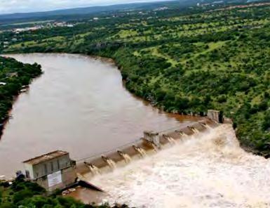
36 Upper Brushy Creek Water Control and Improvement District (UBC WCID) Maintains 23 NRCS (formerly SCS) dams in Upper Brushy Creek watershed 6 auxiliary spillways engaged Dam 3, Dam 4, Dam 6, Dam 7, Dam 8, Dam 13A First recorded discharge through auxiliary spillways Repairs Needed at 4 Dams Minor Erosion Dam 4, 6, 7 Auxiliary Spillways Minor Surface Slides - Dam 13A Total cost for UBC WCID repairs = $750,000

37 Example of UBC WCID Dam with damages Dam 4


38 Dam 4 with Emergency Spillway engaged


39 Damage to private road at bottom of Dam 4 emergency spillway
40 NFIP Claims in Williamson County Before Hermine Hermine 2010 Event (9/7-8/10) City/County Claims Total Losses Paid Claims Total Losses Paid Bartlett 0 $0 0 $0 Cedar Park 20 $148, $547,927 Florence 7 $91,945 3 $57,086 Georgetown 8 $64, $1,653,832 Granger 7 $207,217 0 $0 Hutto 0 $0 0 $0 Leander 12 $357,795 3 $234,278 Liberty Hill 0 $0 0 $0 Round Rock 128 $1,101, $3,534,612 Taylor 16 $109,043 0 $0 Thrall 0 $0 0 $0 Weir 0 $0 0 $0 Williamson County 125 $1,872, $4,631,613 T o t a l 323 $3,952, $10,659,348
41 Two Year Anniversary of T.S. Hermine in Williamson County, Texas Summary Williamson County reported 687 homes were damaged by floodwaters, but we know that not all homeowners completed surveys or reported damages 208 homeowners (30%) filed flood insurance claims for a total of $10.7 million. Average cost per claim = $51,246 Cities reported that many homeowners flooded who did not have flood insurance, primarily attributed to no requirement by mortgage company (either not in mapped floodplain or home paid for in full by owner)
42 Two Year Anniversary of T.S. Hermine in Williamson County, Texas Summary Threshold for Presidential Disaster Declaration of $26.5 million was not met; however, damages were probably under reported Millions in damages to county roads, park facilities and utilities were reported in Williamson County, but other adjacent affected counties failed to report damages. If 687 homes had an average of $51,246 in damages, total residential damages should have been close to $35.2 million in Williamson County alone. Without federal assistance, 2 years later numerous homes have not been fully repaired
43 T.S. Hermine in Williamson County, Texas Future Impacts Some of the damaged utilities in the cities were moved out of the flood hazard areas. None of the homes flooded in Round Rock and Cedar Park (where we had detailed data) were substantially damaged, so the requirements for mitigation to higher standards was not applied. A new watershed based study of the Upper Brushy Creek basin will result in new floodplain maps (2015?), but no other studies or mapping efforts are occurring in the County.
44 Questions Martha Juch, P.E., CFM, D.WRE Project Director, AECOM President of Upper Brushy WCID Board of Direction during TS Hermine Melinda Luna, P.E., CFM Team Lead, Floodplain Mapping Services TWDB/TNRIS

45 Future Events
Ecological Context - Urban settlements are part of their surrounding ecosystem. Austin
 Ecological Context - Urban settlements are part of their surrounding ecosystem Austin Ecotone Division between West and East Flyway Uplift River Balcones Escarpment Central Texas Climate The principal
2012 FLOODS AND DEBRIS REMOVAL
 2012 FLOODS AND DEBRIS REMOVAL June 2012 2012 Floods Tuesday, June 19 AFTERNOON Severe thunderstorms roll across much of the Northland, dropping hail and an initial round of heavy rain in many areas, including
Southington. Challenges
 Southington Southington, similar to its next-door neighbor Berlin, is a suburban community in the southeast part of the region. Originally an agricultural community, Southington has also hosted industry
Managing an Extreme Weather Event of Prolonged Duration May 22, 2013
 Managing an Extreme Weather Event of Prolonged Duration May 22, 2013 MISSOURI RIVER FLOOD OF 2011 M I C H A E L J. K E N N E R L Y P. E. D I R E C T O R O F T H E O F F I C E O F D E S I G N I O W A D
Daily Operations Briefing. Friday, May 5, :30 a.m. EDT
 Daily Operations Briefing Friday, May 5, 2017 8:30 a.m. EDT Significant Activity May 4-5 Significant Events: Flooding Southern/Central Plains Significant Weather: Flash flooding possible Mid-Atlantic through
COMMUNITY EMERGENCY RESPONSE TEAM FLOODS INTRODUCTION
 INTRODUCTION Floods are one of the most common hazards in the United States. A flood occurs any time a body of water rises to cover what is usually dry land. Flood effects can be local, impacting a neighborhood
Daily Operations Briefing Wednesday, February 15, :30 a.m. EST
 Daily Operations Briefing Wednesday, February 15, 2017 8:30 a.m. EST Oroville Dam Spillway Erosion CA Situation Erosion on the main spillway is not expected to expand further upstream and approach the
Flood Scenario Worksheet
 Flood Scenario Worksheet Scenario adapted from: http://www.epa.gov/watersecurity/tools/trainingcd/simple/source/scenario-8/ssc8-0.pdf Simple Tabletop Exercise, Interdependency Natural Disaster Scenario,
Floods. Floods COMMUNITY EMERGENCY RESPONSE TEAM FLOODS CONTENT INSTRUCTOR GUIDANCE
 Floods Floods Introduce this topic by explaining that floods are one of the most common hazards in the United States. A flood occurs any time a body of water rises to cover what is usually dry land. Display
President s Day Weekend Storm Community Meeting and Workshop April 17, 2017
 President s Day Weekend Storm Community Meeting and Workshop April 17, 2017 Meeting outline 1. Progress update on the City of San Jose s recovery efforts 2. Water district presentation on: Weather situation
Superstorm Sandy What Risk Managers and Underwriters Learned
 Superstorm Sandy What Risk Managers and Underwriters Learned Gary Ladman Vice President, Property Underwriting AEGIS Insurance Services, Inc. Superstorm Sandy Change in the Weather Recent years appears
City of Madison Flooding Event AUGUST 20 TH, 2018-PRESENT
 City of Madison Flooding Event AUGUST 20 TH, 2018-PRESENT Presentation Overview Review of Flash Flooding and Flooding from High Lake Levels (August 20 th -Present) Lake Level Information Damages FEMA How
SITUATION REPORT: February 2018 Ohio River Flooding
 SITUATION REPORT: February 2018 Ohio River Flooding Hamilton County Emergency Management Situation Report: #28 Date of Issue: 03/06/2018 Time Issued: 1400 hrs. Prepared By: Irvin Jones Approved By: Ryan
Flood and emergency preparedness CARNATION DUVALL CITIZEN CORPS DUVALL KING COUNTY FIRE DISTRICT 45 SEPTEMBER 11, 2018
 Flood and emergency preparedness CARNATION DUVALL CITIZEN CORPS DUVALL KING COUNTY FIRE DISTRICT 45 SEPTEMBER 11, 2018 Let s get started Important info! Presenters Kathy Brasch, Carnation-Duvall Citizen
Wednesday, March 27, 2019
 Wednesday, March 27, 2019 8:30 a.m. EDT Significant Activity Mar 26-27 Significant Events: Central U.S. Mississippi Valley Flooding Tropical Activity: No activity affecting U.S. interests Significant Weather:
Welcome Jeff Orrock Warning Coordination Meteorologist National Weather Service Raleigh
 Welcome Jeff Orrock Warning Coordination Meteorologist National Weather Service Raleigh Jeff.orrock@noaa.gov Sources: Operational Significant Event Imagery and the Environmental Applications Team (EAT)
Daily Operations Briefing. Thursday, October 26, :30 a.m. EDT
 Daily Operations Briefing Thursday, October 26, 2017 8:30 a.m. EDT Significant Activity Oct 25-26 Significant Events: Response and recovery Tropical Cyclones Harvey, Irma and Maria Tropical Activity: Atlantic
FLOOD/SCS EVENT, APRIL 28 MAY 4
 REPORT DATE: May 4, 2017 EVENT DATE: April 28-May 4, 2017 FLOOD/SCS EVENT, APRIL 28 MAY 4 Event Summary General Significant Flood Outlook. SOURCE: National Weather Service. A significant severe thunderstorm
Daily Operations Briefing Monday, February 13, :30 a.m. EST
 Daily Operations Briefing Monday, February 13, 2017 8:30 a.m. EST Significant Activity Feb 10-13 Significant Events: Oroville Dam Spillway Erosion CA Significant Weather: Heavy Snow Southwest to Southern
Appendix C Fluvial Flood Hazards
 Appendix C Fluvial Flood Hazards Sea Level Rise Vulnerability Assessment and Adaptation Project March 2019 Contents Contents... i Figures... i Tables... i Definitions, Acronyms, & Abbreviations... ii
Daily Operations Briefing. Tuesday, December 5, :30 a.m. EST
 Daily Operations Briefing Tuesday, December 5, 2017 8:30 a.m. EST Thomas Fire CA Fire Name (County) Thomas (Ventura) FMAG # / Approved 5224-FM-CA Dec 5,2017 Acres burned Percent Contained Current Situation
COLORING PAGES. Follow Raindy the Raindrop as he travels from your house out to sea.
 COLORING PAGES www.hcfcd.org Follow Raindy the Raindrop as he travels from your house out to sea. Raindy the Raindrop falls from the sky and lands on your house or in your neighborhood. Once he s on the
Flood Event Analysis to Estimate the Avoided Damages Due to Flood Improvement Projects & Voluntary Buyout Program
 Flood Event Analysis to Estimate the Avoided Damages Due to Flood Improvement Projects & Voluntary Buyout Program Ataul Hannan, P.E., CFM Planning Division Director Harris County Flood Control District
Miami-Dade County Overview
 Miami-Dade County Overview 2,000 square miles World s busiest cruise port 2.6 million residents Second busiest US airport for international travelers Gateway to the Caribbean and Latin America Natural
WHAT HAPPENS WHEN A TORNADO STRIKES THE COMMUNITY? Carroll County Sheriff s Office Emergency Management
 WHAT HAPPENS WHEN A TORNADO STRIKES THE COMMUNITY? Carroll County Sheriff s Office Emergency Management WHAT IS EMERGENCY MANAGEMENT? Carroll County Sheriff s Office Emergency Management Agency is responsible
TROPICAL STORM HERMINE AND HURRICANE MATTHEW HI CERT RESPONSE
 AND HURRICANE MATTHEW HI CERT RESPONSE Hermine hit Hatteras Island on Labor Day 2016 High winds, very heavy rain, causing severe flooding from Avon to Hatteras village Avon had 3+ feet of water throughout
Monday, February 25, :30 a.m. EST
 Monday, February 25, 2019 8:30 a.m. EST Significant Activity Feb 22-25 Significant Events: Severe Weather Tennessee Valley Tropical Activity: No activity affecting U.S. interests Significant Weather: High
Daily Operations Briefing. Tuesday, January 9, :30 a.m. EST
 Daily Operations Briefing Tuesday, January 9, 2018 8:30 a.m. EST Significant Activity Jan 8-9 Significant Events: Flash Flooding CA Tropical Activity: None Significant Weather: Heavy rain and Thunderstorms
From Vulnerability to Resilience And the Tools to Get There. Out of Harm s Way Partnership for the Delaware Estuary August 1, 2012
 From Vulnerability to Resilience And the Tools to Get There Out of Harm s Way Partnership for the Delaware Estuary August 1, 2012 Today s Presentation Tour of New Jersey Challenges Definitions so we re
FOR PROJECTS INITIATED AFTER NOVEMBER 1, 2008 ITEM 716 EMBANKMENT EARTH OUTLET SEDIMENT TRAP
 AFTER NOVEMBER 1, 2008 ITEM 716 EMBANKMENT EARTH OUTLET SEDIMENT TRAP 716.1 Description. This work shall consist of furnishing, installing, maintaining, and removing temporary erosion protection and sediment
Daily Operations Briefing. Saturday, March 17, :30 a.m. EDT
 Daily Operations Briefing Saturday, March 17, 2018 8:30 a.m. EDT Significant Activity Mar 16-17 Significant Events: None Tropical Activity: Western Pacific No activity affecting U.S. interests Significant
March 2010 floods in New London County, Conn., and Washington County, R.I.:
 March 2010 floods in New London County, Conn., and Washington County, R.I.: Impacts and Implications NRE 2215 / project / Benson, Judy / April 19, 2011 1 On March 30 and 31, 2010, southeastern New England
Daily Operations Briefing Tuesday, January 6, :30 a.m. EST
 Daily Operations Briefing Tuesday, January 6, 2015 8:30 a.m. EST Significant Activity: Jan 5-6 Significant Events: Flooding Western WA - FINAL Significant Weather: Snow Northern/Central Rockies to Northern/Central
Daily Operations Briefing Wednesday, April 5, :30 a.m. EDT
 Daily Operations Briefing Wednesday, April 5, 2017 8:30 a.m. EDT Significant Activity Apr 4-5 Significant Events: Severe Weather Southern Plains to Southeast Significant Weather: Severe thunderstorms &
Local Flood Hazards. Click here for Real-time River Information
 Local Flood Hazards Floods of the White River and Killbuck Creek are caused by runoff from general, and/or intense rainfall. Other areas of flooding concern are from the Boland Ditch and Pittsford Ditch.
USING GIS TO MODEL AND ANALYZE HISTORICAL FLOODING OF THE GUADALUPE RIVER NEAR NEW BRAUNFELS, TEXAS
 USING GIS TO MODEL AND ANALYZE HISTORICAL FLOODING OF THE GUADALUPE RIVER NEAR NEW BRAUNFELS, TEXAS ASHLEY EVANS While the state of Texas is well-known for flooding, the Guadalupe River Basin is one of
SNOW REMOVAL GUIDE. City Of Orange Township. Public Works Snow Removal Hotline: (973) My Orange Hotline: (973)
 My Orange Hotline: (973)") Mayor Dwayne D. Warren, Esq. And The Orange Municipal Council MOVING ORANGE FORWARD City Of Orange Township SNOW REMOVAL GUIDE Public Works Snow Removal Hotline: (973) 266-4030 My Orange Hotline: (973)
Mayor Dwayne D. Warren, Esq. And The Orange Municipal Council MOVING ORANGE FORWARD City Of Orange Township SNOW REMOVAL GUIDE Public Works Snow Removal Hotline: (973) 266-4030 My Orange Hotline: (973)
CITY OF NEW LONDON WINTER ROAD & SIDEWALK MAINTENANCE POLICY
 CITY OF NEW LONDON WINTER ROAD & SIDEWALK MAINTENANCE POLICY GENERAL The purpose of this policy is to set up acceptable procedures and policies for the winter maintenance of public areas in the City of
September 13, 2018 MEDIA RELEASE. Waynesboro Department of Emergency Management Waynesboro Police Department Waynesboro Fire Department
 MEDIA RELEASE September 13, 2018 The City continues to prepare for and monitor the track and potential impacts of Hurricane Florence. Current guidance from the National Weather Service, the National Hurricane
CITY OF BEAVER DAM SNOW & ICE REMOVAL POLICY
 CITY OF BEAVER DAM SNOW & ICE REMOVAL POLICY Revised January, 2016 Approved by Operations Committee: February 1, 2016 This snow and ice removal policy guides Public Works personnel with deicing, plowing,
HEC & GIS Modeling of the Brushy Creek HEC & GIS Watershed Modeling of the
 HEC & GIS Modeling of the Brushy Creek HEC & GIS Watershed Modeling of the By Cassandra Fagan 5, December 2014 http://ubcwatershedstudy.ursokr.com/images/ Contents Introduction... 3 Figure 1: 24-hour rainfall
Las Colonias Subdivision September 2010 Flood Study
 Las Colonias Subdivision September 2010 Flood Study Curtis Beitel, P.E., CFM Scott Muchard, P.E. Project Engineer William Badini, CFM Senior Meteorologist Location Map Background Los Colonias Subdivision
TXWARN Tabletop Exercise: Hurricane Helen
 TXWARN Tabletop Exercise: Hurricane Helen July 31, 2015 Administrative Details In-studio participants and remote participants Situation manual Evaluations Training hours 1 In Studio: Welcome and Introductions
Daily Operations Briefing Wednesday, May 3, :30 a.m. EDT
 Daily Operations Briefing Wednesday, May 3, 2017 8:30 a.m. EDT Significant Activity May 2-3 Significant Events: Flooding Southern/Central Plains Significant Weather: Severe thunderstorms possible Southern
Suwannee Satilla Basins Flood Control Issues, Opportunities and Assistance
 Suwannee Satilla Basins Flood Control Issues, Opportunities and Assistance Georgia Silver Jackets Meeting Valdosta, GA April 11, 2013 Presentation Outline Basin overview Recent floods: 2009 100 year flood
CASE STUDY #9 - Brushy Fork Dam, Sugar Grove, West Virginia
 CASE STUDY #9 - Brushy Fork Dam, Sugar Grove, West Virginia Brushy Fork Dam is a flood control structure built by the Soil Conservation Service southeast of the city of Franklin in Pendleton County, West
IN VEHICLES: Do not try to outrun a tornado. Abandon your vehicle and hide in a nearby ditch or depression and cover your head.
 TORNADO SAFETY TORNADO! The very word strikes fear in many people. While a tornado is perhaps nature's most destructive storm, deaths and injuries can be prevented. By following Tornado Safety Rules, lives
Tuesday, March 5, :30 a.m. EST
 Tuesday, March 5, 2019 8:30 a.m. EST Significant Activity Mar 4-5 Significant Events: Severe thunderstorms and tornadoes AL and GA Tropical Activity: No activity affecting U.S. interests Significant Weather:
Daily Operations Briefing. Tuesday, March 27, :30 a.m. EDT
 Daily Operations Briefing Tuesday, March 27, 2018 8:30 a.m. EDT Significant Activity Mar 26-27 Significant Events: None Tropical Activity: Western Pacific No activity affecting U.S. interests Significant
Section 4: Model Development and Application
 Section 4: Model Development and Application The hydrologic model for the Wissahickon Act 167 study was built using GIS layers of land use, hydrologic soil groups, terrain and orthophotography. Within
SUPPLEMENTARY INFORMATION
 SUPPLEMENTARY INFORMATION Supplementary Information Rapid formation of a modern bedrock canyon by a single flood event Michael P. Lamb 1 and Mark A. Fonstad 2 1 California Institute of Technology, Geological
Daily Operations Briefing. Tuesday, March 13, :30 a.m. EDT
 Daily Operations Briefing Tuesday, March 13, 2018 8:30 a.m. EDT Nor easter March 12 & continuing Current Situation A third coastal storm in two weeks will deliver heavy wet snow, gusty winds, and minor
CITY OF RIVERSIDE USING HAZUS TO CREATE A EARTHQUAKE PLANNING GUIDE FOR A UNIFIED FIELD RESPONSE
 CITY OF RIVERSIDE USING HAZUS TO CREATE A EARTHQUAKE PLANNING GUIDE FOR A UNIFIED FIELD RESPONSE Presented by the Phil McCormick City of Riverside Office of Emergency Management HISTORY The City had several
Hydrologic Briefing Tropical Storm Harvey
 Hydrologic Briefing Tropical Storm Harvey 10:30 AM CDT Sunday, August 27, 2017 Prepared by: John Metz NWSCorpus www.weather.gov/corpuschristi Situation Overview Tropical Storm Harvey Harvey to remain a
Wednesday, March 20, :30 a.m. EDT
 Wednesday, March 20, 2019 8:30 a.m. EDT Significant Activity Mar 19-20 Significant Events: Flooding Central U.S. Tropical Activity: No activity affecting U.S. interests Significant Weather: No significant
OC Public Works El Niño Storm Preparation 2015
 OC Public Works El Niño Storm Preparation 2015 December 8, 2015 Overview About OC Public Works Storm Preparation Pre-Storm During Storm Post-Storm Storm Preparation Canyon and Burn Areas County Department
2014 San Gabriel Valley Water Forum. October 2, 2014
 2014 San Gabriel Valley Water Forum October 2, 2014 Panel 3 Are we Ready? Flooding, Fires and Earthquakes Don Boland, California Utilities Emergency Association Southern California Catastrophic Earthquake
Aid to Critical Infrastructure and Key Resources During a Disaster. Pete Grandgeorge MidAmerican Energy Company
 Aid to Critical Infrastructure and Key Resources During a Disaster Pete Grandgeorge MidAmerican Energy Company MidAmerican Energy Company Approximately 3,000 employees and 100 staffed facilities 1.4 million
SURVIVING THE STORM: A Severe Weather Safety Guide for West Texans
 SURVIVING THE STORM: A Severe Weather Safety Guide for West Texans National Weather Service Weather Forecast Office Midland, Texas www.weather.gov/midland Fundamental Definitions WATCH Conditions are favorable
Daily Operations Briefing. Saturday, March 3, :30 a.m. EST
 Daily Operations Briefing Saturday, March 3, 2018 8:30 a.m. EST Northeast Coastal Storm Situation A high-impact and long duration coastal storm is bringing area of heavy rain and snow, significant coastal
CITY OF MINOT SNOW REMOVAL PLAN November 2017
 CITY OF MINOT SNOW REMOVAL PLAN November 2017 1.0 GENERAL This plan has been written to provide information regarding snow removal procedures and policies. The plan provides guidance, while maintaining
United States Multi-Hazard Early Warning System
 United States Multi-Hazard Early Warning System Saving Lives Through Partnership Lynn Maximuk National Weather Service Director, Central Region Kansas City, Missouri America s s Weather Enterprise: Protecting
Daily Operations Briefing Tuesday, December 23, :30 a.m. EST
 Daily Operations Briefing Tuesday, December 23, 2014 8:30 a.m. EST Significant Activity: Dec 22-23 Significant Events: No significant activity Significant Weather: Slight risk of severe thunderstorms and
Working with Natural Stream Systems
 Working with Natural Stream Systems Graydon Dutcher Delaware County Soil & Water Conservation District Stream Corridor Management Program Tropical Storm Sandy October 29,2012 What is a Watershed?
Extreme Weather Events
 Extreme Weather Events DOT Lessons Learned For the Resilient & Sustainable Transportation Systems Program M A Y 2 0 1 7 What is resiliency? AASHTO DEFINITION: The ability to prepare and plan for, absorb,
Daily Operations Briefing. Tuesday, June 27, :30 a.m. EDT
 Daily Operations Briefing Tuesday, June 27, 2017 8:30 a.m. EDT Significant Activity June 26-27 Significant Events: None Tropical Activity: Atlantic Disturbance 1: Low (near 0%) Eastern Pacific Hurricane
Pequabuck River Flooding Study and Flood Mitigation Plan The City of Bristol and Towns of Plainville and Plymouth, CT
 Pequabuck River Flooding Study and Flood Mitigation Plan The City of Bristol and Towns of Plainville and Plymouth, CT Raymond Rogozinski and Maged Aboelata The City of Bristol and Towns of Plainville and
Friday, October 19, :30 a.m. EDT
 Friday, October 19, 2018 8:30 a.m. EDT Significant Activity Oct 18-19 Significant Events: Tropical Storm Michael Response; Central Texas Flooding Tropical Activity: Atlantic No new tropical cyclones expected
Daily Operations Briefing. Monday, July 10, :30 a.m. EDT
 Daily Operations Briefing Monday, July 10, 2017 8:30 a.m. EDT Significant Activity July 7-10 Significant Events: None Tropical Activity: Atlantic Disturbance 1: Low (near 20%) Eastern Pacific Hurricane
Red River Levee Panel
 Red River Levee Panel Mississippi River Commission Monday, August 9, 2017 Red River Levees in LA & AR NONE along TX & OK Boarder Red River Levee Issues Caddo Levee Cherokee Park Authorization Bossier Levee
Daily Operations Briefing. Friday, November 10, :30 a.m. EST
 Daily Operations Briefing Friday, November 10, 2017 8:30 a.m. EST Significant Activity Nov 9-10 Significant Events: None Tropical Activity: Atlantic No tropical cyclones expected next 48 hours Eastern
 Red River Flooding June 2015 Caddo and Bossier Parishes Presented by: Flood Technical Committee Where the Rain Falls Matters I-30 versus I-20 I-20 Backwater and Tributary Floods (Localized) 2016 Flood
Background on the March 13-14, 2007 Flooding in Browns Valley (Traverse County), Minnesota
, Minnesota") Background on the March 13-14, 2007 Flooding in Browns Valley (Traverse County), Minnesota Report to the Minnesota Governor s Office Prepared by: Minnesota Department of Natural Resources Waters Division
Background on the March 13-14, 2007 Flooding in Browns Valley (Traverse County), Minnesota Report to the Minnesota Governor s Office Prepared by: Minnesota Department of Natural Resources Waters Division
Community Discovery Data Questionnaire
 Region III Community Discovery Data Questionnaire Thank you for taking the time to complete this questionnaire. It will provide important information to help FEMA understand flood risk issues in the Conococheague-Opequon
Rebuilding Flood-Conscious Society
 A zone where strong flood flow or river bank erosion by levee breach are anticipated, which likely to occur collapsing/washing away of house. Set up the joint councils by relative stakeholders(river managers,
Monday, November 26, :30 a.m. EST
 Monday, November 26, 2018 8:30 a.m. EST Significant Activity Nov 23-26 Significant Events: CA Wildfires Tropical Activity: Atlantic No new tropical cyclones are expected during the next 5 days Eastern
Daily Operations Briefing Monday, March 13, :30 a.m. EDT
 Daily Operations Briefing Monday, March 13, 2017 8:30 a.m. EDT Significant Activity Mar 10-13 Significant Events: Nor easter Northeastern U.S. March 13-14 Significant Weather: Heavy snow possible Mid-Atlantic
Page G Crow Wing County Multi-Hazard Mitigation Plan, 2017
 Table G - 10. s Identified by the () (From Crow Wing County Master Chart) 1 5 All- Hazards All- Hazards Work to ensure that all Crow Wing County residents are aware of and sign-up for the County s Emergency
Pre-Disaster Natural Hazard Mitigation Plan Guilford, Connecticut History of Hazard Mitigation Planning Authority Disaster Mitigation Act of 2000 (ame
 Pre-Disaster Natural Hazard Mitigation Plan Guilford, Connecticut History of Hazard Mitigation Planning Authority Disaster Mitigation Act of 2000 (amendments to Stafford Act of 1988) Presented by: David
Unit 4. This unit will enable you to improve coordination and communication with State and local agencies when hazardous weather threatens.
 Unit 4 This unit will enable you to improve coordination and communication with State and local agencies when hazardous weather threatens. In this unit we will discuss the role of Emergency Managers in
Daily Operations Briefing December 25, 2012 As of 6:30 a.m. EST
 Daily Operations Briefing December 25, 2012 As of 6:30 a.m. EST 1 Significant Activity: Dec 24-25 Significant Events: Possible Severe thunderstorms - Gulf Coast Sandy/Nor easter recovery Significant Weather:
Saturday, September 1, :30 a.m. EDT
 Saturday, September 1, 2018 8:30 a.m. EDT Significant Activity Aug 31 Sep 1 Significant Events: None Tropical Activity: Atlantic Tropical Storm Florence; Disturbance 1: Medium (40%) Eastern Pacific Hurricane
Daily Operations Briefing. Thursday, November 9, :30 a.m. EST
 Daily Operations Briefing Thursday, November 9, 2017 8:30 a.m. EST Significant Activity Nov 8-9 Significant Events: Tropical Cyclones Harvey, Irma, and Maria Tropical Activity: Atlantic Tropical Storm
APPENDIX E. Photographs of Hazard Events in Broome County. DMA 2000 Hazard Mitigation Plan Broome County, New York E-1
 APPENDIX E Photographs of Hazard Events in Broome County DMA 2000 Hazard Mitigation Plan Broome County, New York E-1 Flood of June 2006 (FEMA DR 1650) Sources: Binghamton NWS Forecast Office / Press and
National Situation Report As of 3:00 a.m. EDT Sunday, April 30, 2017
 Overview National Situation Report As of 3:00 a.m. EDT Sunday, April 30, 2017 Table Of Contents Current Operations Monitoring Recovery National Response Coordination Center: Not Activated National Watch
CITY OF MINOT SNOW REMOVAL PLAN JANUARY 2015
 CITY OF MINOT SNOW REMOVAL PLAN JANUARY 2015 1.0 GENERAL This plan has been written to provide information regarding snow removal procedures and policies. The plan provides guidance, while maintaining
Wednesday, May 30, :30 a.m. EDT
 Wednesday, May 30, 2018 8:30 a.m. EDT Significant Activity May 29-30 Significant Events: Remnants of Tropical Depression Alberto Tropical Activity: Western Pacific No activity affecting U.S. interests
Daily Operations Briefing Wednesday, January 6, :30 a.m. EST
 Daily Operations Briefing Wednesday, January 6, 2016 8:30 a.m. EST Flooding Central U.S. Current Situation: Based on current forecasts for Lower Mississippi River basin, peak crests should be 1 to 3 feet
Monday, May 28, :30 a.m. EDT
 Monday, May 28, 2018 8:30 a.m. EDT Significant Activity May 27-28 Significant Events: Subtropical Storm Alberto; Ellicott City, MD flooding Tropical Activity: Atlantic Subtropical Storm Alberto Significant
Daily Operations Briefing Thursday, June 2, :30 a.m. EDT
 Daily Operations Briefing Thursday, June 2, 2016 8:30 a.m. EDT Significant Activity: June 1- June 2 Significant Events: Flooding Texas Tropical Activity: Pacific: Disturbance 1 HIGH chance (70%) Significant
Daily Operations Briefing Tuesday, November 1, :30 a.m. EDT
 Daily Operations Briefing Tuesday, November 1, 2016 8:30 a.m. EDT Significant Activity Oct 31-Nov 1 Significant Events: None Tropical Activity: Atlantic No tropical cyclone activity expected for the next
3.11 Floodplains Existing Conditions
 Other stormwater control practices may be needed to mitigate water quality impacts. In addition to detention facilities, other practices such as vegetated basins/buffers, infiltration basins, and bioswales
Daily Operations Briefing. Saturday, May 13, :30 a.m. EDT
 Daily Operations Briefing Saturday, May 13, 2017 8:30 a.m. EDT Significant Activity May 12-13 Significant Events: None Significant Weather: Flash Flooding possible Northern NJ and New York City Fire Weather:
Daily Operations Briefing Saturday, June 4, :30 a.m. EDT
 Daily Operations Briefing Saturday, June 4, 2016 8:30 a.m. EDT Significant Activity: June 3-4 Significant Events: Flooding Texas Tropical Activity: Atlantic: Tropical Storm Bonnie Disturbance 1 Pacific:
CITY OF TUSCALOOSA ORGANIZATION OF 2015 FMP FLOODPLAIN MANAGEMENT PLAN
 CITY OF TUSCALOOSA FLOODPLAIN MANAGEMENT PLAN FMPC Meeting #2 July 8, 2015 ORGANIZATION OF 2015 FMP 2015 Floodplain Management Plan Structure Chapter 1 Introduction Chapter 2 Community Profile Chapter
Daily Operations Briefing Wednesday, February 8, :30 a.m. EST
 Daily Operations Briefing Wednesday, February 8, 2017 8:30 a.m. EST Significant Activity Feb 7-8 Significant Events: Severe weather/tornadoes - Louisiana Significant Weather: Freezing rain possible Pacific
Town of Barnstable. Department of Public Work. Snow and Ice Control Operations Plan
 Town of Barnstable Department of Public Work Snow and Ice Control Operations Plan I. Mission: The mission of the Department of Public Works is to remove accumulations of snow and ice from town, county
New Mapping, Recent Events What do we know? June 9, 2011
 New Mapping, Recent Events What do we know? June 9, 2011 e FEMA Mapping Process Current Flood Insurance Rate Maps (FIRMs) or Floodplain Maps date back to the early 1970 s. The District contracted with
Extreme Weather and Climate Change Vulnerability Assessment of Central Texas Transportation Infrastructure
 Extreme Weather and Climate Change Vulnerability Assessment of Central Texas Transportation Infrastructure Federal Highway Administration (FHWA) Pilot Project TxDOT Transportation Planning Conference June
THE 3D SIMULATION INFORMATION SYSTEM FOR ASSESSING THE FLOODING LOST IN KEELUNG RIVER BASIN
 THE 3D SIMULATION INFORMATION SYSTEM FOR ASSESSING THE FLOODING LOST IN KEELUNG RIVER BASIN Kuo-Chung Wen *, Tsung-Hsing Huang ** * Associate Professor, Chinese Culture University, Taipei **Master, Chinese