MER from ground observations: practices and progresses at Osservatorio Etneo for measuring ash clouds-forming eruptions of the Etna volcano
|
|
|
- Margery Shepherd
- 5 years ago
- Views:
Transcription

1 MER from ground observations: practices and progresses at Osservatorio Etneo for measuring ash clouds-forming eruptions of the Etna volcano Mauro Coltelli INGV Osservatorio Etneo, Catania, Italy MeMoVolc Workshop on MER, Reykjavic 3-5 May 2016
2 Overview Ash clouds-forming eruptions of Etna volcano Etna s volcano monitoring system Ground-based eruption plume measurements of Etna s eruption plumes: Thermal and Visible cameras L, S and X Radars UV, Green and NIR Lidars

3 More the 200 ash plume forming eruptions in the last 35 years Airport/Air-traffic disruptions/problems from Guffanti et al, 2007, 2008, 2010 databases, updated 2001 Long lasting ash emission
 Most dangerous volcanoes (>3 events): ETNA, Italy (Catania AP) SAKURA-JIMA, Japan (Kagoshima AP) POPOCATEPETL, Mexico (Mexico City AP) SOUFRIERE HILLS, Montserrat (8")
4 Airports disrupted (>3 events): CATANIA, Italy (Etna) ANCHORAGE, Alaska (Spurr, Redoubt ) KAGOSHIMA, Japan (Sakura-jima) MANADO, Indonesia (Lokon, Soputan) MEXICO CITY, Mexico (Popocatepetl) QUITO, Ecuador (Pichincha, Reventador) Most dangerous volcanoes (>3 events): ETNA, Italy (Catania AP) SAKURA-JIMA, Japan (Kagoshima AP) POPOCATEPETL, Mexico (Mexico City AP) SOUFRIERE HILLS, Montserrat (8 airports) from Guffanti et al. (2003, 2007, 2008) updated databases

5 The last crisis: 46 lava fountain eruptions in 3 years ( ) 2011: 18 episodes from 12 January to 15 November 2012: 7 episodes from 5 January to 24 April : 13 episodes from 19 February to 24 April : 8 episodes from 26 October to 1 January 2014

6 The geophysical, geochemical and video-surveillance monitoring network of Mt Etna


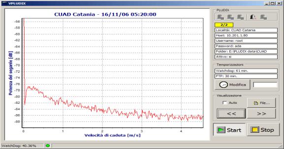

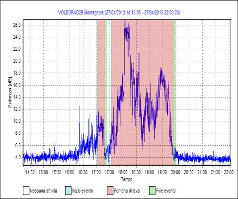
7 Ash emission monitoring at Mt Etna: the ash cloud observations The VOLDORAD IIB (VOLcanic Doppler RADar) Ash fallout The PLUDIX (ash fallout sensor)


8 Ash emission monitoring at Mt Etna: the ash dispersal forecasting Ash cloud dispersal by computer simulation using 3 numerical models (Fall3D, PUFF//, VolCALPUFF) fully automatized daily, performing a 48h forecasting available on a webserver


9 Etna s volcanic plumes monitoring: recent improvement implementation: Proximal radar-doppler in S-band New generation mobile X-band radar New generation mobile NIR lidar The AMPLE lidar station operating on Etna in the Earlinet network

10 Improved visual and thermal observations of a lava fountaining
; h (UTC) T (km) H (km); h (UTC) H (km); h (UTC) 10/04/11")


11 Etna s eruption column height estimations by Scollo et al. ANNALS OF GEOPHYSICS, 57, 2, 2014, S0214 Date ECV SEVIRI MODIS H (km); h (UTC) T (km) H (km); h (UTC) H (km); h (UTC) 10/04/11 > 9.0; 11: ± 0.4; 11:15 10/04/ ± 0.4; 12: ± 0.3; 12:30 09/07/11 > 9.0; 14: ± 0.3; 15:00 12/08/11 > 9.0; 09: ± 0.5; 09:30 12/08/ ± 0.5; 11: ± 0.5; 11:15 7 ± 0.3; 11:15 20/08/11 > 9.0; 07:12 3,0 9.3 ± 0.6; 07:45 29/08/11 > 9.0; 04:40 2,5 7.8 ± 0.4; 04:30 08/09/11 > 9.0; 08: ± 0.4; 08: ± 0.3; 9:20 19/09/ ± 0.5; 12:52 Cloudy 08/10/ ± 0.5; 14:51 3,0 Cloudy 15/11/11 > 9.0; 12:18 2,5 9.9 ± 0.4; 12: ± 0.3; 12:10 05/01/12 > 9.0; 06: ± 0.4; 06:15 09/02/ ± 0.5; 05:45 2,0 7.9 ± 0.5; 05:45 04/03/12 > 9.0; 08: ± 0.4; 08: ± 0.6; 9:10 04/03/ ± 0.5; 09: ± 0.4; 09:00 18/03/12 > 9.0; 09: ± 0.5; 09:30 11 ± 2.3; 9:20 12/04/ ± 0.5; 14:30 3,0 6.7 ± 0.5; 14:40 12/04/ ± 0.5; 15:00 3,0 7.5 ± 0.5; 15:00 28/02/13 > 9.0; 10: ± 0.3; 10:30 03/04/ ± 0.5; 14:19 3,0 5.6 ± 0.6; 14:20 03/04/ ± 0.5; 14:45 3,0 5.8 ± 0.6; 14:45 12/04/ ± 0.5; 11:20 3,0 7.2 ± 0.4; 11: ± 0.3; 12:00 18/04/13 > 9.0; 12: ± 0.4; 12:35 27/04/ ± 0.5; 18:18 3,0 Cloudy

12 lava fountains physical characteristics h plume :12 04:48 02:24 00:00 duration h plume vs. duration :00 01:12 02:24 03:36 04:48 06:00 Dispersal from numerical simulations

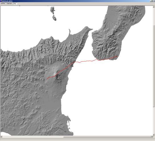
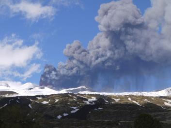
13 The 12 August 2011 eruption

14 Additional cameras for plume monitoring in future


; Elastic backscattering")
15 Lidar measurement with AMPLE Aerosol Multiwavelength Polarization Lidar Experiment The main features of the AMPLE lidar are: -Mobile device -Angular scanning capability - Elastic / Raman receiver apparatus able to detect: Elastic backscattering at 355nm; Nitrogen Raman backscattering 386nm; Water Raman backscattering at 407 nm: Linear depolarization measurements at 355nm; Linear depolarization measurements at 532nm (new AMPLE); Elastic backscattering at 1530nm (new AMPLE).

16 9 8 7 The Lidar observations of 12 August :01-9:11 GMT Range, Km km km 3 Range, Km Backscatter C oeff. x10-5, m -1 sr Backscatter C oeff. x10-5, m -1 sr Particle Depolarization, %


17 The Lidar observations All the measurements were carried out by scanning the sky between 24 and 67 in azimuth since 10:45 GMT. The elevation was fixed.
 inside the plume.")
18 The Lidar observations The depolarization shows high values (around 25%) inside the plume. It is notable that the layer looks quite homogenous.


19 The Lidar observations A scanning angular changing the elevation whit the azimuth fixed was carried out. The first measurement at 10:22 GMT shows a layer of aerosol with a polarization < 20%. Scollo et al., 2014
20 Particle concentration from Lidar measurements on 12 August 2011 From Scollo, S., A. Boselli, M. Coltelli, G. Leto, G. Pisani, M. Prestifilippo, N. Spinelli, and X. Wang (2015), Volcanic ash concentration during the 12 August 2011 Etna eruption, Geophys. Res. Lett.,42,
 Pulse repetition: 100 s Pulse duration: 1 s 11 range gates: 3200-4700m Radial resolution: 150 m Ang.")
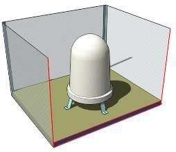
21 Monitoring of Etna by Doppler radar (VOLDORAD 2B, since 2009) Wavelength: 23.5 cm (1274 MHz) Pulse repetition: 100 s Pulse duration: 1 s 11 range gates: m Radial resolution: 150 m Ang. resolution: 500m at 3.2km INGV OPGC Research agreement


22 Near-source Doppler radar monitoring of Etna plumes from Donnadieu et al April 2010 small ash emission 25 August 2010 large ash emission


23 Near-source Doppler radar monitoring of Etna plumes from Donnadieu et al January 2011 plume forming lava fountaining

24 Doppler Radar Vapors-S and Vapors-X for scanning eruptive plumes

![the eruption column Fixed [2 10]km Planar Array](/docs-images/90/104473978/images/25-3.jpg "Antenna (90 cm x 120 cm) Range resolution [30 300]m")


25 VAPORS-S: technical features Parameter Application Installation Operating distance Value Monitoring of the eruption column Fixed [2 10]km Planar Array Antenna (90 cm x 120 cm) Range resolution [30 300]m Angular coverage Measurable speed Measurable reflectivity of the cloud Operating frequency System control 9 degree in azimut 7,2 degree in elevation [0,1 150]m/sec [30 90] dbz 2,8 GHz Local and/or remote Radar all rights reserved 3


26 The Doppler Radar Vapors-S for scanning eruptive column
27 The Doppler Radar Vapor-X for scanning eruptive plume VAPORS-X: technical features The system VAPORS-X is installed on a carriage to allow the operator to select the best site of measurement of the ash cloud whose direction of movement depends on the wind conditions. Parameter Application Installation Operating distance Range resolution Angular coverage Measurable speed Measurable reflectivity of the cloud Operating frequency Value Monitoring of volcanic ash cloud Trasportable [5 30] km [ ] m 1,5 degree in azimut and elevation [0,1 30]m/sec [-30 70] dbz 9,375GHz all rights reserved 5


28 The Doppler Radar Vapors-X for scanning eruptive plume

29 VolcanoGUI VAPORS-S developed by Politecnico of Milan with IDS, Pisa and INGV, Catania

30 VolcanoGUI VAPORS-X developed by Politecnico of Milan with IDS, Pisa and INGV, Catania


31
Ground-based imaging of volcanic plumes for mass flux
 Ground-based imaging of volcanic plumes for mass flux Sébastien Valade 1,(2) A. Harris 2, F. Donnadieu 2, M. Cerminara 3, M. Gouhier 2 1 University of Florence (Laboratorio di Geofisica Sperimentale, Italy)
Explosive volcanic eruptions in the North Pacific: Interactions between the Alaska Volcano Observatory and Volcanic Ash Advisory Centers
 Explosive volcanic eruptions in the North Pacific: Interactions between the Alaska Volcano Observatory and Volcanic Ash Advisory Centers David Schneider U.S. Geological Survey Alaska Volcano Observatory
VAAC TOULOUSE REPORT. WMO VAAC Best Practice Workshop London 5-8 May 2015
 VAAC TOULOUSE REPORT WMO VAAC Best Practice Workshop London 5-8 May 2015 VOLCANIC ERUPTIONS VOLCANIC ERUPTIONS 2012/2015 (up to April 30th) : Issuance of 204 operational VAA/VAG (138 for Mt Etna, 50 for
Detection from Space of Active Volcanism on Earth and, Potentially, on Venus and Rocky Exoplanets
 Detection from Space of Active Volcanism on Earth and, Potentially, on Venus and Rocky Exoplanets Pete Mouginis Mark Hawaii Institute Geophysics and Planetology University of Hawaii Overview Styles of
Satellite techniques for timely detection and near real-time monitoring of volcanic ash clouds for aviation safety
 Satellite techniques for timely detection and near real-time monitoring of volcanic ash clouds for aviation safety N. Pergola A. Falconieri F. Marchese V. Tramutoli Consiglio Nazionale delle Ricerche Istituto
Application of differential SAR interferometry for studying eruptive event of 22 July 1998 at Mt. Etna. Abstract
 Application of differential SAR interferometry for studying eruptive event of 22 July 1998 at Mt. Etna Coltelli M. 1, Puglisi G. 1, Guglielmino F. 1, Palano M. 2 1 Istituto Nazionale di Geofisica e Vulcanologia,
Eyjafjallajökull 2010: Ash and aerosol during and after the eruption
 Eyjafjallajökull 2010: Ash and aerosol during and after the eruption { Evgenia Ilyinskaya, Guðrún Nína Petersen, Sibylle von Löwis, Halldór Björnsson, Matthew J. Roberts, Steinunn S. Jakobsdóttir, Sigurlaug
Near real-time monitoring of the April-May 2010 Eyjafjöll s ash cloud
 Near real-time monitoring of the April-May 2010 Eyjafjöll s ash cloud Labazuy P. and the HotVolc Team Observatoire de Physique du Globe de Clermont-Ferrand, CNRS, Université Blaise Pascal 13th International
Earthquake and Volcano Service
 Ref. Ares(2014)73773-15/01/2014 Earthquake and Volcano Service WP Leader: Istituto Nazionale di Geofisica e Vulcanologia (Italy) Contributors: NILU (Norway), EUCENTRE (Italy), GAMMA (Switzerland), IGAR
University of (1) (2) (3)
 (2) (3)") Outlook: future integrated approaches. Detection and estimation of volcanic eruption onset and mass Eruption rate using MW-sensors and infrasonic array M. Montopoli (1), F.S. Marzano (2,3), L. Mereu (2),
Outlook: future integrated approaches. Detection and estimation of volcanic eruption onset and mass Eruption rate using MW-sensors and infrasonic array M. Montopoli (1), F.S. Marzano (2,3), L. Mereu (2),
Module 1, Investigation 2: Log Sensing volcanic effects from space
 Module 1, Investigation 2: Log Sensing volcanic effects from space Background Volcanoes are extremely disruptive and destructive to the environment and to the people who live nearby. They may disrupt the
Volcanic Ash. Risk Management. GE Aviation Perspective on Operations in a Volcanic Ash Environment. Roger Dinius Jan. 20, 2011
 Volcanic Ash Risk Management Perspective on Operations in a Volcanic Ash Environment Roger Dinius Jan. 20, 2011 Volcano Eruption Impacts Air Travel & Commerce April 15 th eruption closed a large part of
Advantageous GOES IR results for ash mapping at high latitudes: Cleveland eruptions 2001
 GEOPHYSICAL RESEARCH LETTERS, VOL. 32, L02305, doi:10.1029/2004gl021651, 2005 Advantageous GOES IR results for ash mapping at high latitudes: Cleveland eruptions 2001 Yingxin Gu, 1 William I. Rose, 1 David
Volcanic eruptions: Introduction to remote sensing techniques for fine ash and SO2 detection
 Volcanic eruptions: Introduction to remote sensing techniques for fine ash and SO2 detection Bernie Connell Cooperative Institute for Research in the Atmosphere Colorado State University USA Ash clouds
Requirements for a survey system of active volcanoes based on muon radiography
 Requirements for a survey system of active volcanoes based on muon radiography Philippe LABAZUY on behalf of the TOMUVOL Collaboration http://www.tomuvol.fr/ Laboratoire Magmas et Volcans, Laboratoire
Tracking Ash Plumes. Teacher Instructions. Overview: Objectives: Materials: Answers to Student Worksheet:
 Teacher Instructions Tracking Ash Plumes Overview: Composite volcanoes usually erupt with large clouds of ash, called ash plumes. Volcanologists track ash plumes and relay the information to air traffic
MET PANEL (METP) MET OPERATIONS GROUP (MOG) VOLCANIC ASH (VA)
 MET OPERATIONS GROUP (MOG) VOLCANIC ASH (VA)") MOG VA /2 SN/18 18/04/16 MET PANEL (METP) MET OPERATIONS GROUP (MOG) VOLCANIC ASH (VA) SECOND MEETING Buenos Aires, Argentina, 29 April 2016 Agenda Item 6 VAAC Management Reports: VAAC Toulouse, IAVW Management
MOG VA /2 SN/18 18/04/16 MET PANEL (METP) MET OPERATIONS GROUP (MOG) VOLCANIC ASH (VA) SECOND MEETING Buenos Aires, Argentina, 29 April 2016 Agenda Item 6 VAAC Management Reports: VAAC Toulouse, IAVW Management
PHEOS - Weather, Climate, Air Quality
 Aerosol & cloud remote sensing over the Arctic : perspectives for the PHEMOS and meteorological imager payloads on the PCW mission Norm O Neill, Auromeet Saha, U. de Sherbrooke Chris E. Sioris, Jack McConnell,
REFERENCE: The Blue Planet An Introduction to Earth System Science. Brian J. Skinner and Barbara W. Murck (2011) Third Edition. John Wiley and Sons
 Third Edition. John Wiley and Sons") REFERENCE: The Blue Planet An Introduction to Earth System Science. Brian J. Skinner and Barbara W. Murck (2011) Third Edition. John Wiley and Sons Inc. PLATE BOUNDARIES OCEAN FLOOR SEISMIC ACTIVITY WORLD'S
REFERENCE: The Blue Planet An Introduction to Earth System Science. Brian J. Skinner and Barbara W. Murck (2011) Third Edition. John Wiley and Sons Inc. PLATE BOUNDARIES OCEAN FLOOR SEISMIC ACTIVITY WORLD'S
Geophysical Research Letters
 Geophysical Research Letters 28 NOVEMBER 2011 Volume 38 Number 22 Articles published online 16 November 30 November 2011 American Geophysical Union Observing volcanic ash plumes and ballistics using Doppler
Volcanic SO 2 by UV-TIR satellite retrievals: validation by using ground-based network at Mt. Etna
 ; doi: 10.4401/ag-6641 Volcanic SO 2 by UV-TIR satellite retrievals: validation by using ground-based network at Mt. Etna CLAUDIA SPINETTI 1 *, GIUSEPPE GIOVANNI SALERNO 1, TOMMASO CALTABIANO 1, ELISA
Degassing processes and recent activity at Volcán de Colima. Universidad de Colima, Mexico Corresponding author
 Degassing processes and recent activity at Volcán de Colima Nick Varley * & Gabriel Reyes Dávila Universidad de Colima, Mexico Corresponding author email: nick@ucol.mx Volcán de Colima is currently in
Remote Detection and Monitoring of Volcanic Eruptions in the East African Rift
 Remote Detection and Monitoring of Volcanic Eruptions in the East African Rift Simon Carn 1, David Fee 2, Fred Prata 3 1 Department of Geological and Mining Engineering and Sciences, Michigan Technological
Summary report of the EASA/EC Volcanic Ash Cloud workshop
 Draft Summary report of the EASA/EC Volcanic Ash Cloud workshop On 21 st of June an EASA/EC workshop was held in Cologne with the aim of bringing all the European expertise in the field of volcanic ash
Terminal settling velocity measurements of volcanic ash during the Etna eruption by an X-band microwave rain gauge disdrometer
 GEOPHYSICAL RESEARCH LETTERS, VOL. 32, L10302, doi:10.1029/2004gl022100, 2005 Terminal settling velocity measurements of volcanic ash during the 2002 2003 Etna eruption by an X-band microwave rain gauge
Inaugural University of Michigan Science Olympiad Tournament
 Inaugural University of Michigan Science Olympiad Tournament The test may be taken apart. Ties will be broken based on predetermined questions and quality of response. Remote Sensing Test length: 50 Minutes
Satellite detection of volcanic aerosol at Miyakejima and Sakurajima
 Nagasaki Workshop on Aerosol-Cloud Radiation Interaction and Asian Lider Network, Nagasaki, Japan, Nov. 2001 Satellite detection of volcanic aerosol at Miyakejima and Sakurajima M. Koyamada, K. Kinoshita,
Remote Sensing ISSN
 Remote Sens. 2010, 2, 2127-2135; doi:10.3390/rs2092127 Communication OPEN ACCESS Remote Sensing ISSN 2072-4292 www.mdpi.com/journal/remotesensing Determination of Backscatter-Extinction Coefficient Ratio
Eldgos í Eyjafjallajökli hlutverk Veðurstofu Íslands
 Photo: B. Pálmason Eldgos í Eyjafjallajökli hlutverk Veðurstofu Íslands Sigrún Karlsdóttir, Guðrún Nína Petersen, Halldór Björnsson, Halldór Pétursson, Hróbjartur Þorsteinsson, Kristín Vogfjörð og Þórður
The Impacts on Air Traffic of Volcanic Ash from the Okmok and Kasatochi Eruptions During the Summer of 2008
 The Impacts on Air Traffic of Volcanic Ash from the Okmok and Kasatochi Eruptions During the Summer of 2008 Lauren A. Hudnall Christopher Newport University, Newport News, VA A.J. Krueger University of
We are IntechOpen, the world s leading publisher of Open Access books Built by scientists, for scientists. International authors and editors
 We are IntechOpen, the world s leading publisher of Open Access books Built by scientists, for scientists 3,800 116,000 120M Open access books available International authors and editors Downloads Our
Volcanic ash retrieval at Mt. Etna using Avhrr and Modis data
 Volcanic ash retrieval at Mt. Etna using Avhrr and Modis data Claudia Spinetti* a, Stefano Corradini a, Maria F. Buongiorno a a Istituto Nazionale di Geofisica e Vulcanologia, via di Vigna Murata, 605
Monitoring trace gas emissions and transport with Aura and the A-Train
 Monitoring trace gas emissions and transport with Aura and the A-Train Simon Carn Dept. of Geological and Mining Engineering, Michigan Technological University, Houghton, MI Aura (2004-) OMI - SO 2, NO
687 Observation of winter lightning in the Shonai area railroad weather project: preliminary results
 687 Observation of winter lightning in the Shonai area railroad weather project: preliminary results Masahide Nishihashi 1*, Kenichi Shimose 1, Kenichi Kusunoki 2, Syugo Hayashi 2, Kotaro Bessho 3, Shnsuke
Meteorological Priorities in Support of a Volcanic Ash Strategy ( )
") Meteorological Priorities in Support of a Volcanic Ash Strategy (2010-11) Ian Lisk, Met Office Volcanic Ash Coordination Programme Manager; EUMETNET VA coordinator; WMO CAeM vice-president. Introduction
Meteorological Priorities in Support of a Volcanic Ash Strategy (2010-11) Ian Lisk, Met Office Volcanic Ash Coordination Programme Manager; EUMETNET VA coordinator; WMO CAeM vice-president. Introduction
Washington Volcanic Ash Advisory Center
 How a Volcanic Ash Advisory and a Dispersion Forecast is Prepared: Jamie Kibler Washington VAAC Operations Manger/Meteorologist October 25, 2011 ICAO Seminar on Volcanic Ash Products and Communications
Volcanic Ash Cloud Observation using Ground-based Ka-band Radar and Near-Infrared Lidar Ceilometer during the Eyjafjallajökull eruption
 ANNALS OF GEOPHYSICS, Fast Track 2, 214; doi: 1.441/ag-6634 Volcanic Ash Cloud Observation using Ground-based Ka-band Radar and Near-Infrared Lidar Ceilometer during the Eyjafjallajökull eruption FRANK
Satellite detection of volcanic aerosol at Miyakejima and Sakurajima
 Satellite detection of volcanic aerosol at Miyakejima and Sakurajima M. Koyamada 1, K. Kinoshita 1, N. Iino 2 and C. Kanagaki 3 1 Faculty of Education, Kagoshima University, 1-20-6, Korimoto, Kagoshima
Towards a Volcanic Information System (VIS) using IMS infrasound data
 using IMS infrasound data") Towards a Volcanic Information System (VIS) using IMS infrasound data in support of the VAACs in the framework of ARISE Project L. Ceranna 1, T. Arnal 2, A. Le Pichon 2, P. Gaillard 2, E. Blanc 2, N. Brachet
Towards a Volcanic Information System (VIS) using IMS infrasound data in support of the VAACs in the framework of ARISE Project L. Ceranna 1, T. Arnal 2, A. Le Pichon 2, P. Gaillard 2, E. Blanc 2, N. Brachet
Raman and elastic lidar techniques for aerosol observation at CIAO
 Raman and elastic lidar techniques for aerosol observation at CIAO F. Madonna, A. Amodeo, I. Binietoglou, G. D Amico, A. Giunta, L. Mona, G. Pappalardo Consiglio Nazionale delle Ricerche, Istituto di Metodologie
Long-term aerosol and cloud database from correlative CALIPSO and EARLINET observations
 Long-term aerosol and cloud database from correlative CALIPSO and EARLINET observations Ulla Wandinger, Anja Hiebsch, Ina Mattis Leibniz Institute for Tropospheric Research, Leipzig, Germany Gelsomina
Chemistry of SO 2 in tropospheric volcanic plumes
 Chemistry of SO 2 in tropospheric volcanic plumes by Dr. Lizzette A. Rodríguez Iglesias Department of Geology University of Puerto Rico Mayagüez Campus Photo: L. Rodriguez http://volcano-pictures.info/glossary/volcanic_gas.html
Satellite Data For Applications: Aviation/Volcanic Ash. Richard Eckman NASA 27 May 2013
 Satellite Data For Applications: Aviation/Volcanic Ash Richard Eckman NASA 27 May 2013 Background Following the unprecedented disruption to aviation by the recent eruptions of Eyjafjallajökull and Grímsvötn
1 Fundamentals of Lidar
 1 Fundamentals of Lidar The lidar profiling technique (Fiocco, 1963) is based on the study of the interaction between a laser radiation sent into the atmosphere and the atmospheric constituents. The interaction
The BEYOND Center of Excellence for monitoring natural disasters from space
 The BEYOND Center of Excellence for monitoring natural disasters from space Ioannis Papoutsis National Observatory of Athens Institute for Astronomy, Astrophysics, Space Applications & Remote Sensing MOWE-IT
Lecture 20. Wind Lidar (2) Vector Wind Determination
 Vector Wind Determination") Lecture 20. Wind Lidar (2) Vector Wind Determination Vector wind determination Ideal vector wind measurement VAD and DBS technique for vector wind Coherent versus incoherent Detection Doppler wind lidar
Lecture 20. Wind Lidar (2) Vector Wind Determination Vector wind determination Ideal vector wind measurement VAD and DBS technique for vector wind Coherent versus incoherent Detection Doppler wind lidar
Data assimilation and inverse problems. J. Vira, M. Sofiev
 Data assimilation and inverse problems J. Vira, M. Sofiev SILAM winter school, 2013 Introduction How to combine observations and model fields into an estimate of the atmospheric state? Chemical data assimilation
Ground-based Validation of spaceborne lidar measurements
 Ground-based Validation of spaceborne lidar measurements Ground-based Validation of spaceborne lidar measurements to make something officially acceptable or approved, to prove that something is correct
WORLD METEOROLOGICAL ORGANIZATION =====================================
 WORLD METEOROLOGICAL ORGANIZATION ===================================== WORLD METEOROLOGICAL ORGANIZATION (WMO) IN CLOSE COLLABORATION WITH THE INTERNATIONAL CIVIL AVIATION ORGANIZATION (ICAO) AND THE
HYSPLIT volcanic ash dispersion modeling R&D, NOAA NWS NCEP operations, and transfer to operations
 HYSPLIT volcanic ash dispersion modeling R&D, NOAA NWS NCEP operations, and transfer to operations Barbara Stunder 1, Alice Crawford 1,2, Tianfeng Chai 1,2, Michael Pavolonis 3 1 NOAA OAR Air Resources
Volcanic, Weather and Climate Effects on Air Transport
 Volcanic, Weather and Climate Effects on Air Transport Ulrich Schumann German Aerospace Center Institute of Atmospheric Physics Oberpfaffenhofen, Germany Content: - Volcanic ash hazard avoidance by improved
Development of a System for Quantitatively Analyzing Volcanic Clouds
 Development of a System for Quantitatively Analyzing Volcanic Clouds Michael Pavolonis (NOAA/NESDIS/STAR) Justin Sieglaff and John Cintineo (UW-CIMSS) Marco Fulle - www.stromboli.net 2 nd IUGG-WMO Workshop
AUTOMATIC MONITORING OF BOUNDARY LAYER STRUCTURES WITH CEILOMETER ABSTRACT
 AUTOMATIC MONITORING OF BOUNDARY LAYER STRUCTURES WITH CEILOMETER Christoph Münkel 1, Reijo Roininen 1 Vaisala GmbH, Schnackenburgallee 1d, 55 Hamburg, Germany Phone +9 89 1, Fax +9 89 11, E-mail christoph.muenkel@vaisala.com
LIDAR. Natali Kuzkova Ph.D. seminar February 24, 2015
 LIDAR Natali Kuzkova Ph.D. seminar February 24, 2015 What is LIDAR? Lidar (Light Detection And Ranging) is an optical remote sensing technology that measures distance by illuminating a target with a laser
Volcanic plume modelling and assimilation with the global MACC system (with emphasis on SO 2 )
") Volcanic plume modelling and assimilation with the global MACC system (with emphasis on SO 2 ) Johannes Flemming, Antje Inness, Angela Benedetti & Jean-Jacques Morcrette Introduction How can we use timely
Volcanic plume modelling and assimilation with the global MACC system (with emphasis on SO 2 ) Johannes Flemming, Antje Inness, Angela Benedetti & Jean-Jacques Morcrette Introduction How can we use timely
WLS70: A NEW COMPACT DOPPLER WIND LIDAR FOR BOUNDARY LAYER DYNAMIC STUDIES.
 WLS70: A NEW COMPACT DOPPLER WIND LIDAR FOR BOUNDARY LAYER DYNAMIC STUDIES. VALIDATION RESULTS AND INTERCOMPARISON IN THE FRAME OF THE 8TH CIMO-WMO CAMPAIGN. S. Lolli 1, L.Sauvage 1, M. Boquet 1, 1 Leosphere,
Monitoring Volcanoes. An introduction to monitoring techniques. Name: Class: Date:
 Monitoring Volcanoes An introduction to monitoring techniques Name: Class: Date: Aims To understand how volcanoes are monitored in order to predict when they will erupt To understand the importance of
USGS Volcano Hazards Program
 USGS Volcano Hazards Program NAS Board on Earth Sciences and Resources May 12, 2014 Charlie Mandeville USGS Program Coordinator cmandeville@usgs.gov www.volcanoes.usgs.gov Volcano Hazards Program Mission:
A New Automatic Pattern Recognition Approach for the Classification of Volcanic Tremor at Mount Etna, Italy
 A New Automatic Pattern Recognition Approach for the Classification of Volcanic Tremor at Mount Etna, Italy M. Masotti 1, S. Falsaperla 2, H. Langer 2, S. Spampinato 2, R. Campanini 1 1 Medical Imaging
2D Wind Field Estimation with Higher Spatial Resolution Using Dual Compact X-Band Weather Radars
 2D Wind Field Estimation with Higher Spatial Resolution Using Dual Compact X-Band Weather Radars 95th AMS Annual Meeting, Phoenix, Arizona By FURUNO ELECTRIC CO.,LTD January 5th, 2015 Contents 1. Introduction
NSF-MARGINS Expedition to Anatahan Volcano March 2005
 1 NSF-MARGINS Expedition to Anatahan Volcano March 2005 According to the Emergency Management Office (EMO) report distributed in February 2005, the third historical eruption of Anatahan began on January
What are Aerosols? Suspension of very small solid particles or liquid droplets Radii typically in the range of 10nm to
 What are Aerosols? Suspension of very small solid particles or liquid droplets Radii typically in the range of 10nm to 10µm Concentrations decrease exponentially with height N(z) = N(0)exp(-z/H) Long-lived
Satellite observation of atmospheric dust
 Satellite observation of atmospheric dust Taichu Y. Tanaka Meteorological Research Institute, Japan Meteorological Agency 11 April 2017, SDS WAS: Dust observation and modeling @WMO, Geneva Dust observations
Atmospheric aerosol characterization in the urban area of Napoli
 Atmospheric aerosol characterization in the urban area of Napoli M.Armenante 1, A. Boselli 2, L. Nasti 3, G.Pica 4 N.Spinelli 3, X.Wang 5 1. INFN Sezione di Napoli - ITALY 2.CNR -IMAAi - ITALY 3. CNISM
Effect of UV scattering on SO 2 emission rate measurements
 GEOPHYSICAL RESEARCH LETTERS, VOL. 33, L17315, doi: 10.1029/2006GL026285, 2006 Effect of UV scattering on SO 2 emission rate measurements Takehiko Mori, 1 Toshiya Mori, 2 Kohei Kazahaya, 1 Michiko Ohwada,
Following volcanic ash as a hazard to aviation and as a factor in climate. John Merrill University of Rhode Island Graduate School of Oceanography
 Following volcanic ash as a hazard to aviation and as a factor in climate John Merrill University of Rhode Island Graduate School of Oceanography Volcanic plumes as hazards to aviation The silicate ash
ACTRIS aerosol vertical profiles: advanced data and their potential use in a aerosol observations/models combined approach
 ACTRIS aerosol vertical profiles: advanced data and their potential use in a aerosol observations/models combined approach Lucia Mona CNR-IMAA, Potenza, Italy mona@imaa.cnr.it and EARLINET Team OUTLINE
EUMETNET Statement for the EASA Workshop Volcanic Ash Cloud: Detection, Observation, Measurement, Modelling The Way Forward
 EUMETNET Statement for the EASA Workshop Volcanic Ash Cloud: Detection, Observation, Measurement, Modelling The Way Forward Cologne, 21 st June 2010 Background GIE EUMETNET (the network of European Meteorological
Coordinated Monitoring of Ash Eruptions in the Russian Far East and Alaska
 Coordinated Monitoring of Ash Eruptions in the Russian Far East and Alaska Dr. John Eichelberger, Program Coordinator, Volcano Hazards Program, US Geological Survey, Reston, Virginia, USA Academician Evgeny
Aerosols and clouds observations using active lidar remote sensing
 ÓPTICA PURA Y APLICADA Vol. 37, núm. 3-2004 Aerosols and clouds observations using active lidar remote sensing C. Pietras (1), Y. Morille (1), B. Romand (1), F. Lapouge (1), C. Boitel (1), M. Grall (1),
Volcanic Ash Monitoring Claus Zehner, ESA
 Volcanic Ash Monitoring Claus Zehner, ESA Slide: 1 Support to Aviation Control Service A global Alert (and Analysis demonstration only) system for volcanic Ash and SO2 emissions using satellite measurements
R E C E N T P R O G R E S S A N D F U T U R E O P P O R T U N I T I E S I N V O L C A N O M O N I T O R I N G U S I N G I N F R A S O U N D
 R E C E N T P R O G R E S S A N D F U T U R E O P P O R T U N I T I E S I N V O L C A N O M O N I T O R I N G U S I N G I N F R A S O U N D D A V I D F E E G E O P H Y S I C A L I N S T I T U T E A L A
The contributions of the EU-funded MEDiterranean SUpersite Volcanoes (MED-SUV) project to the assessment of volcanic ash hazard
 project to the assessment of volcanic ash hazard") The contributions of the EU-funded MEDiterranean SUpersite Volcanoes (MED-SUV) project to the assessment of volcanic ash hazard S.Barsotti, F.Buongiorno, M.Coltelli, A.Costa, E.Del Bello, M.de Michieli
The contributions of the EU-funded MEDiterranean SUpersite Volcanoes (MED-SUV) project to the assessment of volcanic ash hazard S.Barsotti, F.Buongiorno, M.Coltelli, A.Costa, E.Del Bello, M.de Michieli
Lecture 14. Principles of active remote sensing: Lidars. Lidar sensing of gases, aerosols, and clouds.
 Lecture 14. Principles of active remote sensing: Lidars. Lidar sensing of gases, aerosols, and clouds. 1. Optical interactions of relevance to lasers. 2. General principles of lidars. 3. Lidar equation.
Mountain Snowpacks, Climate Change and the Silver Solution
 Mountain Snowpacks, Climate Change and the Silver Solution Climate Change Seminar Series University of Nevada Las Vegas 11 July 2012 Arlen Huggins Desert Research Institute Reno, Nevada Climate, snow and
Easy, Accurate Aerosol Profiling Weather forecasting Atmospheric observation Aviation safety MICRO PULSE LIDAR. Commercial.
 MICRO PULSE LIDAR Easy, Accurate Aerosol Profiling Weather forecasting Atmospheric observation Aviation safety Services Division Commercial Division Aerospace Instruments Division SIGMA SPACE CORPORATION
Figure 1: Tephigram for radiosonde launched from Bath at 1100 UTC on 15 June 2005 (IOP 1). The CAPE and CIN are shaded dark and light gray,
. The CAPE and CIN are shaded dark and light gray,") Figure 1: Tephigram for radiosonde launched from Bath at 1100 UTC on 1 June 200 (IOP 1). The CAPE and CIN are shaded dark and light gray, respectively; the thin solid line partially bounding these areas
Figure 1: Tephigram for radiosonde launched from Bath at 1100 UTC on 1 June 200 (IOP 1). The CAPE and CIN are shaded dark and light gray, respectively; the thin solid line partially bounding these areas
Observation of Smoke and Dust Plume Transport and Impact on the Air Quality Remote Sensing in New York City
 Observation of Smoke and Dust Plume Transport and Impact on the Air Quality Remote Sensing in New York City Yonghua Wu*, Chowdhury Nazmi, Cuiya Li, Daniel Hoyos, Barry Gross, Fred Moshary NOAA-CREST and
Ash Plumes. Teacher Instructions. Overview: Objectives: National Standards: Alaska Grade Level Expectations Addressed:
 Teacher Instructions Ash Plumes Overview: Composite volcanoes usually erupt with large clouds of ash, called ash plumes. Volcanologists track ash plumes and relay the information to air traffic controllers
IMPACT OF AEROSOLS FROM THE ERUPTION OF EL CHICHÓN ON BEAM RADIATION IN THE PACIFIC NORTHWEST
 IX. IMPACT OF AEROSOLS FROM THE ERUPTION OF EL CHICHÓN ON BEAM RADIATION IN THE PACIFIC NORTHWEST The eruptions of the Mexican volcano El Chichón over the period of March 28 to April 4, 1982 ejected an
CATS GSFC TEAM Matt McGill, John Yorks, Stan Scott, Stephen Palm, Dennis Hlavka, William Hart, Ed Nowottnick, Patrick Selmer, Andrew Kupchock
 The Cloud-Aerosol Transport System (CATS) CATS GSFC TEAM Matt McGill, John Yorks, Stan Scott, Stephen Palm, Dennis Hlavka, William Hart, Ed Nowottnick, Patrick Selmer, Andrew Kupchock CATS LaRC Team Chip
Data Assimilation of Satellite Lidar Aerosol Observations
 Data Assimilation of Satellite Lidar Aerosol Observations Thomas Sekiyama Meteorological Research Institute Japan Meteorological Agency (MRI/JMA) AICS Data Assimilation Workshop, 27 February 2013, Kobe,
Pavlof. Alaska Peninsula N, W; summit elev. 2,519 m. All times are local (= UTC - 9 hours)
") Pavlof Alaska Peninsula 55.42 N, 161.887 W; summit elev. 2,519 m All times are local (= UTC - 9 hours) Eruption in May-June 2013 with lava flows and ash emissions to ~8.5 km a.s.l. Pavlof, the most active
Pavlof Alaska Peninsula 55.42 N, 161.887 W; summit elev. 2,519 m All times are local (= UTC - 9 hours) Eruption in May-June 2013 with lava flows and ash emissions to ~8.5 km a.s.l. Pavlof, the most active
Climate Discovery Teacher s Guide
 Unit:Little Ice Age Lesson: 8 Materials & Preparation Time: Preparation: 30 minutes Teaching: Two, 45- minute, class periods Materials for the Teacher: Dark Skies PowerPoint presentation (or overhead transparencies)
Lidar and radiosonde measurement campaign for the validation of ENVISAT atmospheric products
 Lidar and radiosonde measurement campaign for the validation of ENVISAT atmospheric products V. Cuomo, G. Pappalardo, A. Amodeo, C. Cornacchia, L. Mona, M. Pandolfi IMAA-CNR Istituto di Metodologie per
Geophysical Journal International
 Geophysical Journal International Geophys. J. Int. (21) 183, 1376 1391 doi: 1.1111/j.1365-246X.21.4829.x The geometry of Strombolian explosions: insights from Doppler radar measurements Mathieu Gouhier
Applying Mass Eruption Rates in an Operational Dispersion Model
 Applying Mass Eruption Rates in an Operational Dispersion Model Frances Beckett, ADAQ, Met Office frances.beckett@metoffice.gov.uk MeMoVolc Workshop, University of Iceland, May 2016 The London Volcanic
Innovations in dispersion modeling using FALL3D and operations at the Buenos Aires VAAC
 www.bsc.es Innovations in dispersion modeling using FALL3D and operations at the Buenos Aires VAAC A. Folch Barcelona Supercomputing Center (BSC-CNS), Spain Co-workers: A. Costa (1), G. Macedonio (1),
Observatory of Environmental Safety Resource Center, Research Park. St.Petersburg. Russia.
 Correct atmospheric optics modelling: Theory and Experiment Irina Melnikova Observatory of Environmental Safety Resource Center, Research Park St.Petersburg State University St.Petersburg. Russia. irina.melnikova@pobox.spbu.ru
EARLINET, the ACTRIS aerosol vertical profiling component
 EARLINET, the ACTRIS aerosol vertical profiling component L. Mona* and the EARLINET team *CNR-IMAA, Consiglio Nazionale delle Ricerche, Istituto di Metodologie per l Analisi Ambientale ITALY OUTLINE What
Recent Improvement of Integrated Observation Systems in JMA
 Recent Improvement of Integrated Observation Systems in JMA Mr Osamu Suzuki and Mr Yoshihiko Tahara Japan Meteorological Agency 1-3-4 Otemachi, Chiyoda-ku, Tokyo 100-8122, Japan Tel: +81-3-3212-8341, Fax:
Aira/Sakura-jima. Kyushu, Japan N, E; summit elev m. All times are local (= UTC + 9 hours)
") Aira/Sakura-jima Kyushu, Japan 31.593 N, 130.657 E; summit elev. 1117 m All times are local (= UTC + 9 hours) 2012-2013 Ongoing frequent explosions; ashfall on Kagoshima City This report summarizes activity
Aira/Sakura-jima Kyushu, Japan 31.593 N, 130.657 E; summit elev. 1117 m All times are local (= UTC + 9 hours) 2012-2013 Ongoing frequent explosions; ashfall on Kagoshima City This report summarizes activity
Volcanic Plumes. JOHN WILEY & SONS Chichester New York Weinheim Brisbane Singapore Toronto
 Volcanic Plumes R. S. J. SPARKS University of Bristol, UK M. I. BURSIK State University of New York, USA S. N. CAREY University of Rhode Island, USA J. S. GILBERT Lancaster University, UK L. S. GLAZE NASA/Goddard
Assimilation of Satellite Infrared Brightness Temperatures and Doppler Radar Observations in a High-Resolution OSSE
 Assimilation of Satellite Infrared Brightness Temperatures and Doppler Radar Observations in a High-Resolution OSSE Jason Otkin and Becky Cintineo University of Wisconsin-Madison, Cooperative Institute
VAAC Operational Dispersion Model Configuration Snap Shot Version 2. March 2016
 VAAC Operational Dispersion Model Configuration Snap Shot Version 2 March 2016 Introduction The VAACs are responsible for producing volcanic ash cloud analysis and forecasts to assist the aviation community
3D VOLCANIC AEROSOL DISPERSAL: A COMPARISON BETWEEN MISR DATA AND NUMERICAL SIMULATIONS
 3D VOLCANIC AEROSOL DISPERSAL: A COMPARISON BETWEEN MISR DATA AND NUMERICAL SIMULATIONS S. Scollo 1*, A. Folch 2, M. Coltelli 1, V. J. Realmuto 3 (1) Istituto Nazionale di Geofisica e Vulcanologia - Sezione
WORKING PAPER IAVW FIFTH MEETING. reports (VONA) (Presented by IUGG) SUMMARY. countries. States. It is 1.1. International. development and.
 (Presented by IUGG) SUMMARY. countries. States. It is 1.1. International. development and.") International Civil Aviation Organization 20/11/09 WORKING PAPER INTERNATIONAL AIRWAYS VOLCANO WATCH OPERATIONS GROUP (IAVWOPSG) FIFTH MEETING Lima, Peru, 15 to 19 March 2010 Agenda Item 5: Operation of
International Civil Aviation Organization 20/11/09 WORKING PAPER INTERNATIONAL AIRWAYS VOLCANO WATCH OPERATIONS GROUP (IAVWOPSG) FIFTH MEETING Lima, Peru, 15 to 19 March 2010 Agenda Item 5: Operation of
Satellite analysis and PUFF simulation of the eruptive cloud generated by the Mount Etna paroxysm of 22 July 1998
 JOURNAL OF GEOPHYSICAL RESEARCH, VOL. 107, NO. B12, 2373, doi:10.1029/2001jb000630, 2002 Satellite analysis and PUFF simulation of the eruptive cloud generated by the Mount Etna paroxysm of 22 July 1998
Recent activity. Current episode 12 years Transition between styles 4 periods of dome growth Since 2003, Vulcanian explosions (4 25 per day)
") Recent activity Current episode 12 years Transition between styles 4 periods of dome growth Since 2003, Vulcanian explosions (4 25 per day) 02 December 09 Explosions originating from dome e.g. 10 Jan 2010
Recent activity Current episode 12 years Transition between styles 4 periods of dome growth Since 2003, Vulcanian explosions (4 25 per day) 02 December 09 Explosions originating from dome e.g. 10 Jan 2010
Lecture 11: Doppler wind lidar
 Lecture 11: Doppler wind lidar Why do we study winds? v Winds are the most important variable studying dynamics and transport in the atmosphere. v Wind measurements are critical to improvement of numerical