Weather and Travel Time Decision Support
|
|
|
- Lorin Benson
- 5 years ago
- Views:
Transcription
1 Weather and Travel Time Decision Support Gerry Wiener, Amanda Anderson, Seth Linden, Bill Petzke, Padhrig McCarthy, James Cowie, Thomas Brummet, Gabriel Guevara, Brenda Boyce, John Williams, Weiyan Chen
2 Overview The Pikalert System The value of accurate travel time information A domain of interest: the I-70 mountain corridor in Colorado Historical dataset description Travel time statistics on I-70 How weather affects travel times How mobile observations benefit travel time prediction The role of machine learning in travel time prediction Summary

3 The Pikalert System

4 Snow, Precip, Temp and Winds
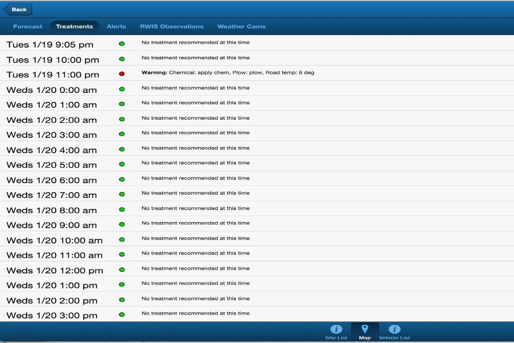
5 Treatments
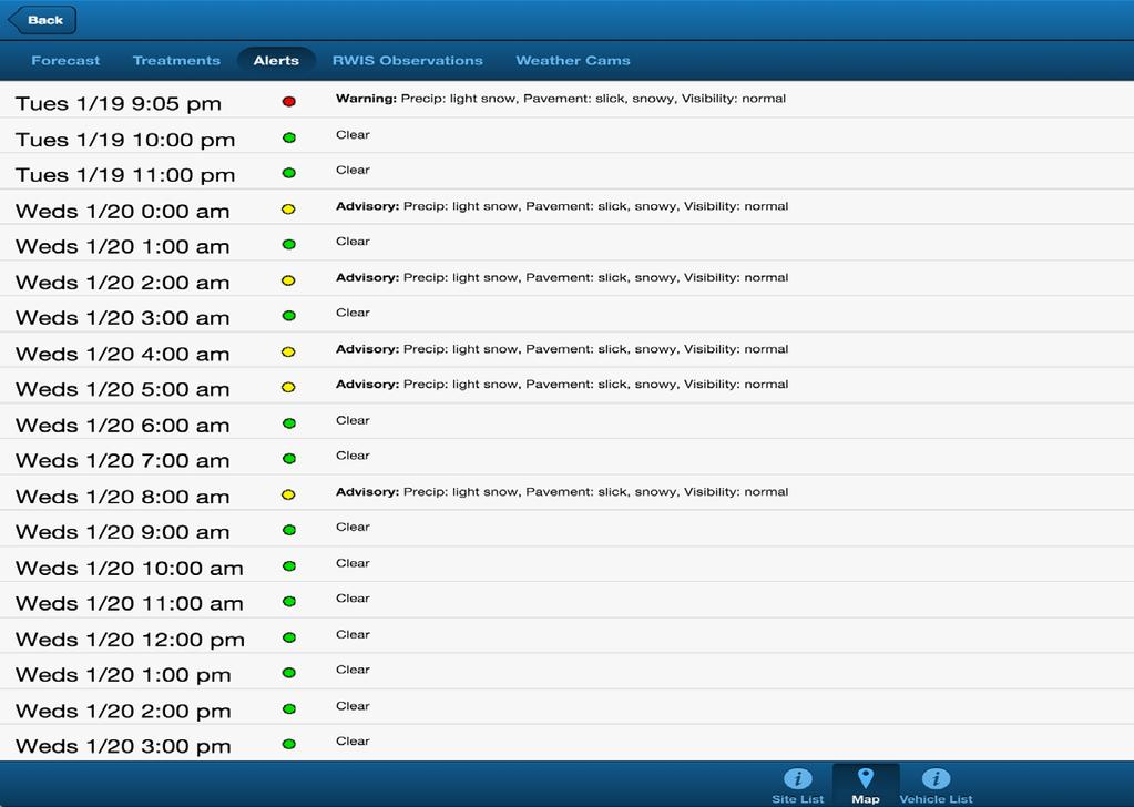
6 Alerts
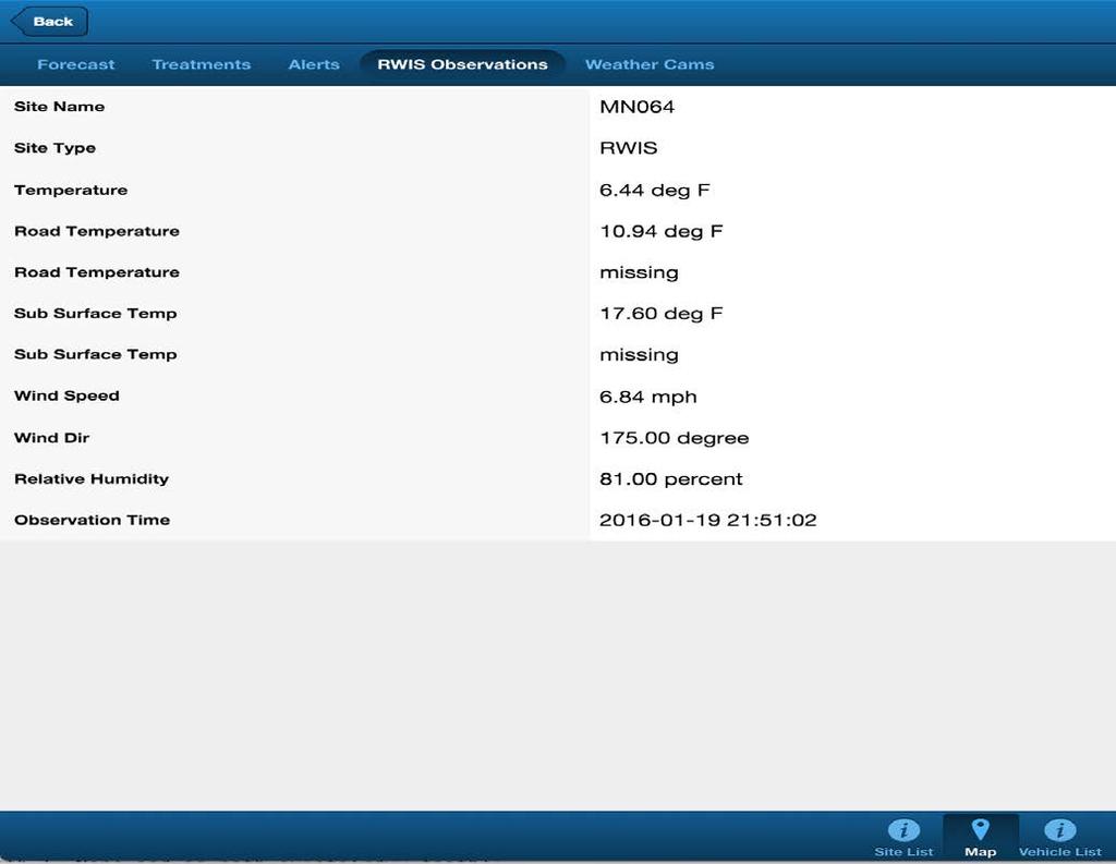
7 RWIS

8 RWIS Camera Image
9 The Pikalert System What does Pikalert do? Integrates mobile observations, weather observations, and weather forecasts to provide road maintenance decision support and guidance to the travelling public out to 72 hours Why does Pikalert leverage mobile observations? To assist in assessing current road conditions For road weather, condition, treatment forecast tuning
10 The Pikalert System The Pikalert display contains: Current and forecast road conditions Current vehicle observations RWIS observations Road segment information Pikalert supports: Drilling down to road conditions on a particular road segment based on mobile and other meteorological observations
11 Scheduled Pikalert Enhancements Improved display functionality Radar overlays and looping RWIS camera images Refinements to precipitation and road slickness forecasting Dual polarization radar Desired Enhancement: Travel time support
12 The Value of Accurate Travel Time Information Accurate Travel Time Information Supports making better travel decisions and effective use of time Route selection Departure scheduling Mode of transportation Maintenance guidance Reduces uncertainty with regard to arrival time State DOTs are interested in making use of better highway travel time forecasts in conjunction with hazardous weather prediction Should be augmented with traffic and weather information
13 Domain of Interest I-70 mountain corridor from Golden to Vail (mile markers 261 through 176) Golden 5674 feet (mm 261) Idaho Springs 7524 feet (mm 240) Georgetown 8530 feet (mm 228) Eisenhower Tunnel 11,158 feet (mm216) Silverthorne 9035 feet (mm205) Copper Mountain 9712 feet (mm195) Vail Pass 10,662 feet (mm 190) Vail 8150 feet (mm176)

14 Domain of Interest
15 Domain of Interest 34 westbound and eastbound road segments between Golden and Vail Distance: 84.5 miles Travel time: approximately 90 minutes Road segments vary from approximately one mile to twelve miles in length
16 Tunnel Traffic ~11 million vehicles traveled through the Eisenhower Tunnel in 2013 On the 4 day Martin Luther King Jr holiday weekend in 2013, ~ vehicles traveled through the tunnel ~200 accidents per year occur at the tunnel
17 Historical Dataset Description Traffic and qualitative road condition information were obtained from Colorado Department of Transportation (CDOT) Historical dataset consists of both traffic and observed weather information Quantitative weather information was gathered from the National Weather Service Data set covers Jan 1, 2014 through Aug 30, 2015 (~5 GB of ASCII data)
18 Historical Dataset Description Date, time Two minute data Solar zenith, azimuth Road segment information Id, length, start mile marker, end mile marker Travel time in seconds (target of interest) Road condition information Temperature Dew point Wind speed and direction Precipitation rate Precipitation accumulation Visibility Road temperature
19 Travel Time Statistics on I-70 Average travel times on road segments vary from 1 to 14 minutes (corresponds to segment lengths) The 99 th percentile travel times vary from 1½ minutes to 24 minutes depending on the road segments The maximum travel times vary from 7½ minutes to 6.6 hours (< 1 percent of the time) On March 7, 2014 Eastbound traffic was shut down due to multiple accidents and westbound traffic was at a standstill between Georgetown and the Eisenhower Tunnel.


20 Heavy Traffic at a Standstill on I-70 March 7, 2014
21 How Weather Impacts Travel Times Consider Vail at mm 176 Westbound road segment from mm to 177 (12.4 miles) Average travel time in seconds: 785 (~13 min) 25 th percentile: 698 seconds 75 th percentile: 805 seconds 90 th percentile: 970 seconds (~16 min) 99 th percentile: 1404 seconds (~23 min) Max: 8929 seconds (~149 minutes)

22 How Weather Impacts Travel Times

23 How Weather Impacts Travel Times
24 How Weather Impacts Travel Times Long term winter month average low, high temperatures at Vail weather station from 1981 to 2010 Oct: 25, 54 deg F Nov: 15, 37 deg F Dec: 7, 27 deg F Jan: 5, 28 deg F Feb: 9, 33 deg F March: 16, 41deg F April: 23, 49 deg F
25 The Role of Mobile Observations in Travel Time Prediction Mobile observations provide high resolution road condition information Methods for knowing the weather? RWIS Radar (if available) Video cameras Mobile Observations Wipers (Off, on, low, medium, high) Speed Automatic braking system (ABS) Traction control Fog lights Knowing the weather on the road can be used in tuning road weather prediction models
26 The Role of Machine Learning in Travel Time Prediction What is machine learning? Subfield of computer science Pattern recognition For example: Classifying as spam or non-spam Classifying an image of a road as snowy or clear Uses statistical and algorithmic techniques Supervised learning involves establishing a set of predictors and a target variable to be predicted.
27 The Role of Machine Learning in Travel Time Prediction Our intuition tells us that the following should have an effect on travel time (potential predictors): Time of day Day of week Month of year Holidays Snowfall Heavy rain Fog (low visibility) Icy roads Accidents Construction Machine learning can assist in modeling these effects
28 The Role of Machine Learning in Travel Time Prediction A common sense predictor of travel time: The previous hour s travel time Would not be a good predictor when road conditions are changing quickly Would not want to use previous hour s travel time in the following scenarios: Hour prior to rush hour => rush hour No snow => snow Clear => thunderstorm No fog => fog
29 The Role of Machine Learning in Travel Time Prediction A combined model: Use a model based on recent hour travel time information when conditions on the road are expected to be stable and change slowly Utilize a different model when significant road condition changes are expected such as significant changes in weather
30 Summary Pikalert provides enhanced decision support and guidance by integrating mobile observations with road weather, condition and treatment forecasts Mobile observations are important in assessing current road conditions and support tuning of weather forecast models Accurate travel time, road weather and traffic information have significant value to the travelling public Adverse weather has a significant impact on travel times Machine learning techniques can be utilized in modeling travel especially when road conditions are changing quickly Multiple travel time models are beneficial in addressing stable conditions versus rapidly changing conditions

31 Questions Please
Road Weather Management Program
 Road Weather Management Program AASHTO/TRB Joint Maintenance Conference: Highway Safety & Reliability (Winter Maintenance and Highway Safety and Reliability) 7/22/2015 Gabe Guevara. P.E. FHWA Office of
Steven Chien Kung-E Cheng New Jersey Institute of Technology. David Bowlby New Jersey Department of Transportation
 Steven Chien Kung-E Cheng New Jersey Institute of Technology David Bowlby New Jersey Department of Transportation The 11th MDSS Stakeholder Meeting Charlotte, NC September 16, 2009 NJ-MDSS Goals Improve
Responsive Traffic Management Through Short-Term Weather and Collision Prediction
 Responsive Traffic Management Through Short-Term Weather and Collision Prediction Presenter: Stevanus A. Tjandra, Ph.D. City of Edmonton Office of Traffic Safety (OTS) Co-authors: Yongsheng Chen, Ph.D.,
Federal Maintenance Decision Support System (MDSS) Prototype Update
 Prototype Update") Federal Maintenance Decision Support System (MDSS) Prototype Update Kevin R. Petty, Ph.D. National Center for Atmospheric Research Boulder, Colorado, USA MDSS Meeting 6 August 2008 Reno, Nevada Historical
Federal Maintenance Decision Support System (MDSS) Prototype Update Kevin R. Petty, Ph.D. National Center for Atmospheric Research Boulder, Colorado, USA MDSS Meeting 6 August 2008 Reno, Nevada Historical
ROAD PAVEMENT TEMPERATURES AND THEIR IMPACT ON TRAVEL DURING SNOW STORMS. Donald M. Moore, NOAA/NWS, Billings, MT; and R. J.
 ROAD PAVEMENT TEMPERATURES AND THEIR IMPACT ON TRAVEL DURING SNOW STORMS Donald M. Moore, NOAA/NWS, Billings, MT; and R. J. Miller 1. INTRODUCTION The National Weather Service issues a variety of products
Deploying the Winter Maintenance Support System (MDSS) in Iowa
 in Iowa") Deploying the Winter Maintenance Support System (MDSS) in Iowa Dennis A. Kroeger Center for Transportation Research and Education Iowa State University Ames, IA 50010-8632 kroeger@iastate.edu Dennis Burkheimer
Deploying the Winter Maintenance Support System (MDSS) in Iowa Dennis A. Kroeger Center for Transportation Research and Education Iowa State University Ames, IA 50010-8632 kroeger@iastate.edu Dennis Burkheimer
Center for Transportation Research and Education. Winter Maintenance Operations & Maintenance Decision Support System TRANS 691 Seminar March 5, 2004
 Center for Transportation Research and Education Winter Maintenance Operations & Maintenance Decision Support System TRANS 691 Seminar March 5, 2004 1 Why Winter Maintenance? Weather related traffic accidents
Active Traffic & Safety Management System for Interstate 77 in Virginia. Chris McDonald, PE VDOT Southwest Regional Operations Director
 Active Traffic & Safety Management System for Interstate 77 in Virginia Chris McDonald, PE VDOT Southwest Regional Operations Director Interstate 77 at Fancy Gap Mountain Mile markers 0-15 Built in late
Fusion of xfcd and local road weather data for a reliable determination of the road surface condition SIRWEC Prague 2008
 Fusion of xfcd and local road weather data for a reliable determination of the road surface condition SIRWEC Prague 2008 Alexander Dinkel, Axel Leonhardt Technische Universität München Chair of Traffic
Road Weather Research Mike Chapman
 Road Weather Research Mike Chapman mchapman@ucar.edu NCAR Research Applications Lab Boulder, CO Why Invest in Road Weather Research Safety Over 1,500,000, crashes occur each year during poor weather conditions,
Evaluating the Potential of Remote Sensing Rural Road and Travel Conditions
 82 TRANSPORTATION RESEARCH RECORD 1409 Evaluating the Potential of Remote Sensing Rural Road and Travel Conditions KEVIN A. FRENCH AND EUGENE M. WILSON Communication of current road and travel conditions
Champaign-Urbana 2001 Annual Weather Summary
 Champaign-Urbana 2001 Annual Weather Summary ILLINOIS STATE WATER SURVEY 2204 Griffith Dr. Champaign, IL 61820 wxobsrvr@sws.uiuc.edu Maria Peters, Weather Observer January: After a cold and snowy December,
Weather Information for Road Managers
 Weather Information for Road Managers by Paul A. Pisano, Lynette C. Goodwin and Andrew D. Stern How Does Weather Affect Roads? The complex interactions between weather and roads have major affects on traffic
FHWA Road Weather Management Program Update
 FHWA Road Weather Management Program Update 2015 Winter Maintenance Peer Exchange Bloomington, MN September 21-25, 2015 Gabe Guevara FHWA Office of Operations Road Weather Management Team 2015 Winter Maintenance
10/18/2016 The Hoosier Co. Inc W. 86th Street, Indianapolis, IN
 10/18/2016 The Hoosier Co. Inc. 5421 W. 86th Street, Indianapolis, IN 46268 1 Today s Topics Weather impacts What is RWIS? How old is this tool? Key RWIS Technology/Innovation Key RWIS sensing parameters
UDOT Weather Program Traffic Operations Center
 UDOT Weather Program Traffic Operations Center Presentation Goals You MUST account for weather in your Traffic Management program Provide you with information on proven tools and strategies You NEED a
Road Surface Condition Analysis from Web Camera Images and Weather data. Torgeir Vaa (SVV), Terje Moen (SINTEF), Junyong You (CMR), Jeremy Cook (CMR)
, Terje Moen (SINTEF), Junyong You (CMR), Jeremy Cook (CMR)") Road Surface Condition Analysis from Web Camera Images and Weather data Torgeir Vaa (SVV), Terje Moen (SINTEF), Junyong You (CMR), Jeremy Cook (CMR) Motivation Cameras installed along roads for surface
Road Surface Condition Analysis from Web Camera Images and Weather data Torgeir Vaa (SVV), Terje Moen (SINTEF), Junyong You (CMR), Jeremy Cook (CMR) Motivation Cameras installed along roads for surface
CoCoRaHS Monitoring Colorado s s Water Resources through Community Collaborations
 CoCoRaHS Monitoring Colorado s s Water Resources through Community Collaborations Nolan Doesken Colorado Climate Center Atmospheric Science Department Colorado State University Presented at Sustaining
Cost-Benefit Analysis of the Pooled- Fund Maintenance Decision Support System: Case Study
 Cost-Benefit Analysis of the Pooled- Fund Maintenance Decision Support System: Case Study Zhirui Ye (WTI) Xianming Shi (WTI) Christopher K. Strong (City of Oshkosh) 12 th AASHTO-TRB TRB Maintenance Management
What are Intelligent Transportation Systems? Major ITS Areas
 Intelligent Transportation Systems in Small Cities and Rural Areas Indiana Road School March 20, 2001 Steven Beningo Federal Highway Administration Midwestern Resource Center What are Intelligent Transportation
Denver International Airport MDSS Demonstration Verification Report for the Season
 Denver International Airport MDSS Demonstration Verification Report for the 2015-2016 Season Prepared by the University Corporation for Atmospheric Research Research Applications Division (RAL) Seth Linden
Appendix BAL Baltimore, Maryland 2003 Annual Report on Freeway Mobility and Reliability
 (http://mobility.tamu.edu/mmp) Office of Operations, Federal Highway Administration Appendix BAL Baltimore, Maryland 2003 Annual Report on Freeway Mobility and Reliability This report is a supplement to:
Evaluation of NDDOT Fixed Automated Spray Technology (FAST) Systems November 24, 2009
 Systems November 24, 2009") Evaluation of NDDOT Fixed Automated Spray Technology (FAST) Systems November 4, 009 Shawn Birst, PE Program Director, ATAC Associate Research Fellow Upper Great Plains Transportation Institute North Dakota
Evaluation of NDDOT Fixed Automated Spray Technology (FAST) Systems November 4, 009 Shawn Birst, PE Program Director, ATAC Associate Research Fellow Upper Great Plains Transportation Institute North Dakota
Getting through the winter safely
 CARTE BLANCHE PROJECTS Getting through the winter safely The Canton of Lucerne s Road Inspection Office looks after the operation and maintenance of the canton s roads and streets, and has joint responsibility
MeteoGroup RoadMaster. The world s leading winter road weather solution
 MeteoGroup RoadMaster The world s leading winter road weather solution Discover why RoadMaster is the world s leading winter road weather solution. Managing winter road maintenance means that you carry
Denver International Airport MDSS Demonstration Verification Report for the Season
 Denver International Airport MDSS Demonstration Verification Report for the 2014-2015 Season Prepared by the University Corporation for Atmospheric Research Research Applications Division (RAL) Seth Linden
Regional influence on road slipperiness during winter precipitation events. Marie Eriksson and Sven Lindqvist
 Regional influence on road slipperiness during winter precipitation events Marie Eriksson and Sven Lindqvist Physical Geography, Department of Earth Sciences, Göteborg University Box 460, SE-405 30 Göteborg,
Weather Responsive Traffic Management. Wyoming DOT Variable Speed Limit (VSL) Project. March 2012
 Project. March 2012") Weather Responsive Traffic Management Wyoming DOT Variable Speed Limit (VSL) Project March 2012 I-80 Background Information >50% of I-80 traffic in Wyoming is commercial vehicles Rural AADT 11,000 vehicles
Weather Responsive Traffic Management Wyoming DOT Variable Speed Limit (VSL) Project March 2012 I-80 Background Information >50% of I-80 traffic in Wyoming is commercial vehicles Rural AADT 11,000 vehicles
Decision Support Part 1: Tools to aid travel planning
 Decision Support Part 1: Tools to aid travel planning Decision Support: Tools to Aid Travel Planning Decision support systems are so much more than simply saying when to plow and how much chemical to apply.
WeatherCloud Hyper-Local Global Forecasting All rights reserved. Fathym, Inc.
 WeatherCloud Hyper-Local Global Forecasting based on current forecast techniques EVOLVING FORECASTING TECHNOLOGY 1) The WeatherCloud backend forecast system allows for routing around hazardous weather
Corridor Integrated Weather System (CIWS) MIT Lincoln Laboratory. CIWS D. Meyer 10/21/05
 MIT Lincoln Laboratory. CIWS D. Meyer 10/21/05") Corridor Integrated Weather System () Outline Example of Weather Impacting Air traffic Impacts on worst delay day Ways to reduce delay Improve forecasts Aid traffic flow management Aviation Delay Problem
Corridor Integrated Weather System () Outline Example of Weather Impacting Air traffic Impacts on worst delay day Ways to reduce delay Improve forecasts Aid traffic flow management Aviation Delay Problem
MDSS and Advanced Forecasting STSMO Weather Workshop Dave Huft, SDDOT Research Program Manager September 12, 2017
 Connecting South Dakota and the Nation MDSS and Advanced Forecasting STSMO Weather Workshop Dave Huft, SDDOT Research Program Manager September 12, 2017 1 Weather Impacts & Strategies Winter perceived
May 2016 Volume 23 Number 5
 The Weather Wire May 2016 Volume 23 Number 5 Contents: Winter Summary Current Colorado and West-wide Snow Pack Drought Monitor April Summary/Statistics May Preview Snowfall Totals Winter Summary The Front
1,836 people die and 136,309 people are injured every year from icy roads in the US.
 Winter Driving The United States Department of Transportation (USDOT) Federal Highway Administration reports that 1,836 people die and 136,309 people are injured every year from icy roads in the US. 2
The Weather Wire. Current Colorado Snowpack. Contents:
 The Weather Wire December 2018 Volume 25 Number 12 Contents: Current Colorado Snowpack Drought Monitor November Summary/Statistics December Preview Snowfall Totals Current Colorado Snowpack Although snowfall
The Pavement Precipitation Accumulation Estimation System (PPAES)
") The Pavement Precipitation Accumulation Estimation System (PPAES) Mark Askelson Assistant Professor (Dept. Atmospheric Sciences) Surface Transportation Weather Research Center University of North Dakota
The Pavement Precipitation Accumulation Estimation System (PPAES) Mark Askelson Assistant Professor (Dept. Atmospheric Sciences) Surface Transportation Weather Research Center University of North Dakota
Drought in Southeast Colorado
 Drought in Southeast Colorado Nolan Doesken and Roger Pielke, Sr. Colorado Climate Center Prepared by Tara Green and Odie Bliss http://climate.atmos.colostate.edu 1 Historical Perspective on Drought Tourism
Applications/Users for Improved S2S Forecasts
 Applications/Users for Improved S2S Forecasts Nolan Doesken Colorado Climate Center Colorado State University WSWC Precipitation Forecasting Workshop June 7-9, 2016 San Diego, CA First -- A short background
Lab 19.2 Synoptic Weather Maps
 Lab 19.2 Synoptic Weather Maps Name: Partner: Purpose The purpose of this lab is to have you read and interpret the information displayed on synoptic weather maps. You will also learn the techniques used
The Weather Wire. Current Colorado Snowpack. Contents:
 The Weather Wire January 2019 Volume 26 Number 1 Contents: Current Colorado Snowpack Denver Snowfall Since 1999-2000 Denver 2018 Climate Review Drought Monitor December Summary/Statistics January Preview
Mountain View Community Shuttle Monthly Operations Report
 Mountain View Community Shuttle Monthly Operations Report December 6, 2018 Contents Passengers per Day, Table...- 3 - Passengers per Day, Chart...- 3 - Ridership Year-To-Date...- 4 - Average Daily Ridership
Increasing Transmission Capacities with Dynamic Monitoring Systems
 INL/MIS-11-22167 Increasing Transmission Capacities with Dynamic Monitoring Systems Kurt S. Myers Jake P. Gentle www.inl.gov March 22, 2012 Concurrent Cooling Background Project supported with funding
Transportation and Road Weather
 Portland State University PDXScholar TREC Friday Seminar Series Transportation Research and Education Center (TREC) 4-18-2014 Transportation and Road Weather Rhonda Young University of Wyoming Let us know
Since the winter of , when the studded tire
 Field Test of Road Weather Information Systems and Improvement of Winter Road Maintenance in Hokkaido Masaru Matsuzawa, Yasuhiko Kajiya, and Keishi Ishimoto, Hokkaido Development Bureau, Civil Engineering
2003 Water Year Wrap-Up and Look Ahead
 2003 Water Year Wrap-Up and Look Ahead Nolan Doesken Colorado Climate Center Prepared by Odie Bliss http://ccc.atmos.colostate.edu Colorado Average Annual Precipitation Map South Platte Average Precipitation
Champaign-Urbana 2000 Annual Weather Summary
 Champaign-Urbana 2000 Annual Weather Summary ILLINOIS STATE WATER SURVEY 2204 Griffith Dr. Champaign, IL 61820 wxobsrvr@sws.uiuc.edu Maria Peters, Weather Observer January: January started on a mild note,
Planed treatment recommendations
 Planed treatment recommendations for the MDSS ASFiNAG up-to-date 18 th September 2007 Albert Mathis, Dipl. Ing FH, Executive MBA, AnyData AG, Switzerland albert.mathis@anydata.ch MDSS - MDSS Stakeholder
EXAMINATION OF THE SAFETY IMPACTS OF VARYING FOG DENSITIES: A CASE STUDY OF I-77 IN VIRGINIA
 0 0 0 EXAMINATION OF THE SAFETY IMPACTS OF VARYING FOG DENSITIES: A CASE STUDY OF I- IN VIRGINIA Katie McCann Graduate Research Assistant University of Virginia 0 Edgemont Road Charlottesville, VA 0 --
Northgate School District Closing and Delay Information
 Northgate School District Closing and Delay Information Due to the climate of our region, winter weather often creates challenges. The goal of the Northgate School District will always be to operate on
Section 12. Winter Storms
 Section 12. Winter Storms Contents Why Winter Storms are a Threat...12-1 Hazard Profile...12-1 History of Winter Storms...12-4 People and Property at Risk...12-7 Potential Damages and Losses...12-7 Why
National Symposium on Extreme Weather Event Impacts on Transportation Infrastructure
 National Symposium on Extreme Weather Event Impacts on Transportation Infrastructure May 22, 2013 Extreme Winter Lake Effect Operations and Maintenance Gregory C. Johnson, PE Chief Operations Officer Michigan
Memo. I. Executive Summary. II. ALERT Data Source. III. General System-Wide Reporting Summary. Date: January 26, 2009 To: From: Subject:
 Memo Date: January 26, 2009 To: From: Subject: Kevin Stewart Markus Ritsch 2010 Annual Legacy ALERT Data Analysis Summary Report I. Executive Summary The Urban Drainage and Flood Control District (District)
School for Highway Superintendents Real-Time Local Weather Information
 School for Highway Superintendents Real-Time Local Weather Information Mark W. Wysocki Senior Lecturer in Meteorology Cornell University New York State Climatologist Keith Eggleston and Kathy Veerland
HAZARD DESCRIPTION... 1 LOCATION... 1 EXTENT... 1 HISTORICAL OCCURRENCES...
 WINTER STORM HAZARD DESCRIPTION... 1 LOCATION... 1 EXTENT... 1 HISTORICAL OCCURRENCES... 3 SIGNIFICANT PAST EVENTS... 4 PROBABILITY OF FUTURE EVENTS... 5 VULNERABILITY AND IMPACT... 5 Hazard Description
Champaign-Urbana 1998 Annual Weather Summary
 Champaign-Urbana 1998 Annual Weather Summary ILLINOIS STATE WATER SURVEY Audrey Bryan, Weather Observer 2204 Griffith Dr. Champaign, IL 61820 wxobsrvr@sparc.sws.uiuc.edu The development of the El Nìno
The Climate of Grady County
 The Climate of Grady County Grady County is part of the Central Great Plains, encompassing some of the best agricultural land in Oklahoma. Average annual precipitation ranges from about 33 inches in northern
Severe Weather Watches, Advisories & Warnings
 Severe Weather Watches, Advisories & Warnings Tornado Watch Issued by the Storm Prediction Center when conditions are favorable for the development of severe thunderstorms and tornadoes over a larger-scale
Development and Use of the Swedish Road Weather Information System
 Development and Use of the Swedish Road Weather Information System by Lennart Axelson Director at the International Secretariat Swedish National Road Administration SE-781 87 Borlänge, SWEDEN Introduction
ALASKA ITS. Vehicles and Observations in the cloud
 ALASKA ITS Vehicles and Observations in the cloud 1 YOUR PRESENTERS Wilf Nixon, Salt Institute Mark DeVries, Vaisala Dan Schacher, ADOT&PF 2 Today s Agenda A Cloud Based Overview connected and autonomous
ROAD WEATHER INFORMATION SYSTEM DEVICE TESTING LEVEL C
 Page 1 of 11 Date: Jan. 05, 2009 This procedure outlines Level C device test to be performed on Road Weather Information System. Level C device testing demonstrates that each device is fully operational
2003 Moisture Outlook
 2003 Moisture Outlook Nolan Doesken and Roger Pielke, Sr. Colorado Climate Center Prepared by Tara Green and Odie Bliss http://climate.atmos.colostate.edu Through 1999 Through 1999 Fort Collins Total Water
TMC Monthly Operational Summary
 TMC Monthly Operational Summary July 1 Bureau of Transportation Systems Management & Operations (TSMO) NH Department of Transportation s Mission Transportation excellence enhancing the quality of life
Effect of Environmental Factors on Free-Flow Speed
 Effect of Environmental Factors on Free-Flow Speed MICHAEL KYTE ZAHER KHATIB University of Idaho, USA PATRICK SHANNON Boise State University, USA FRED KITCHENER Meyer Mohaddes Associates, USA ABSTRACT
MET Lecture 20 Mountain Snowstorms (CH16)
") MET 4300 Lecture 20 Mountain Snowstorms (CH16) Learning Objectives Provide an overview of the importance and impacts of mountain snowstorms in the western US Describe how topography influence precipitation
MET 4300 Lecture 20 Mountain Snowstorms (CH16) Learning Objectives Provide an overview of the importance and impacts of mountain snowstorms in the western US Describe how topography influence precipitation
PRELIMINARY DRAFT FOR DISCUSSION PURPOSES
 Memorandum To: David Thompson From: John Haapala CC: Dan McDonald Bob Montgomery Date: February 24, 2003 File #: 1003551 Re: Lake Wenatchee Historic Water Levels, Operation Model, and Flood Operation This
Winter Climate Forecast
 Winter 2018-2019 Climate Forecast 26 th Winter Weather Meeting, OMSI and Oregon AMS, Portland Kyle Dittmer Hydrologist-Meteorologist Columbia River Inter-Tribal Fish Commission Portland, Oregon Professor
Winter Climate Forecast
 Winter 2017-2018 Climate Forecast 25 th Winter Weather Meeting, OMSI and Oregon AMS, Portland Kyle Dittmer Hydrologist-Meteorologist Columbia River Inter-Tribal Fish Commission Portland, Oregon Professor
Winter-Weather Forecast Research
 Winter-Weather Forecast Research Dr. Jennifer Bewley 23 April 2014 AvMet Applications, Inc. 1800 Alexander Bell Dr., Ste. 130 Reston, 1 VA 20191 Number of Hours with Wintry Precipitation November 2013
Understanding Weather and Climate Risk. Matthew Perry Sharing an Uncertain World Conference The Geological Society, 13 July 2017
 Understanding Weather and Climate Risk Matthew Perry Sharing an Uncertain World Conference The Geological Society, 13 July 2017 What is risk in a weather and climate context? Hazard: something with the
What Does It Take to Get Out of Drought?
 What Does It Take to Get Out of Drought? Nolan J. Doesken Colorado Climate Center Colorado State University http://ccc.atmos.colostate.edu Presented at the Insects, Diseases and Drought Workshop, May 19,
INCA-CE achievements and status
 INCA-CE achievements and status Franziska Strauss Yong Wang Alexander Kann Benedikt Bica Ingo Meirold-Mautner INCA Central Europe Integrated nowcasting for the Central European area This project is implemented
AWOS Level Descriptions
 AWOS Level Descriptions AWOS System Configurations. The AWOS is a modular system utilizing a central processor which may receive input from several sensors. Eight standard groups of sensors are defined
A Tale of Time Travel Year 2018
 A Tale of Time Travel Year 2018 1 1 Question: 2 2 Answer: Integrated Modeling for Road Condition Prediction (IMRCP) Kyle Garrett, Synesis Partners Nancy Powell, MoDOT/KC Scout 3 So what is it? Historic
Funding provided by NOAA Sectoral Applications Research Project CLIMATE. Basic Climatology Colorado Climate Center
 Funding provided by NOAA Sectoral Applications Research Project CLIMATE Basic Climatology Colorado Climate Center Remember These? Factor 1: Our Energy Source Factor 2: Revolution & Tilt Factor 3: Rotation!
Road Weather: The Science Behind What You Know
 The Weather Road Weather: The Science Behind What You Know Jon Tarleton Global Roads Marketing Manager Meteorologist Jon.tarleton@vaisala.com Page 2 / date / name / Internal use / Vaisala Weather and Our
Winter Maintenance Report
 98.4 Official State Snowfall 150 Truck Stations 1,813 Full-time and Backup Snowfighters 840 Plow trucks - includes 47 reserve plows 30,585 Lane Miles 85% Frequency Achieving Bare Lanes 2017-18 Winter Maintenance
Tracking the Climate Of Northern Colorado Nolan Doesken State Climatologist Colorado Climate Center Colorado State University
 Tracking the Climate Of Northern Colorado Nolan Doesken State Climatologist Colorado Climate Center Colorado State University Northern Colorado Business Innovations November 20, 2013 Loveland, Colorado
Colorado s 2003 Moisture Outlook
 Colorado s 2003 Moisture Outlook Nolan Doesken and Roger Pielke, Sr. Colorado Climate Center Prepared by Tara Green and Odie Bliss http://climate.atmos.colostate.edu How we got into this drought! Fort
TMC Monthly Operational Summary
 TMC Monthly Operational Summary March Bureau of Transportation Systems Management & Operations (TSMO) NH Department of Transportation s Mission Transportation excellence enhancing the quality of life in
Probabilistic Winter Weather Nowcasting supporting Total Airport Management
 Probabilistic Winter Weather Nowcasting supporting Total Airport Management Jaakko Nuottokari* Finnish Meteorological Institute *With Heikki Juntti, Elena Saltikoff, Harri Hohti, Seppo Pulkkinen, Alberto
The Climate of Kiowa County
 The Climate of Kiowa County Kiowa County is part of the Central Great Plains, encompassing some of the best agricultural land in Oklahoma. Average annual precipitation ranges from about 24 inches in northwestern
MTO s Road Weather Information System (RWIS)
") MTO s Road Weather Information System (RWIS) Ontario Good Roads Association Managing Winter Operations Workshop October 19, 2017 Overview of MTO s Road Weather Information Station (RWIS) RWIS for Winter
MTO s Road Weather Information System (RWIS) Ontario Good Roads Association Managing Winter Operations Workshop October 19, 2017 Overview of MTO s Road Weather Information Station (RWIS) RWIS for Winter
What s New in the World of Winter Maintenance Technology. Laser Road Surface Sensor (LRSS) Functional Description
 Functional Description") What s New in the World of Winter Maintenance Technology Dennis Burkheimer Winter Operations Administrator Iowa Department of Transportation John Scharffbillig Fleet Manager Minnesota Department of Transportation
What s New in the World of Winter Maintenance Technology Dennis Burkheimer Winter Operations Administrator Iowa Department of Transportation John Scharffbillig Fleet Manager Minnesota Department of Transportation
The Climate of Murray County
 The Climate of Murray County Murray County is part of the Crosstimbers. This region is a transition between prairies and the mountains of southeastern Oklahoma. Average annual precipitation ranges from
FIELD EVALUATION OF SMART SENSOR VEHICLE DETECTORS AT RAILROAD GRADE CROSSINGS VOLUME 4: PERFORMANCE IN ADVERSE WEATHER CONDITIONS
 CIVIL ENGINEERING STUDIES Illinois Center for Transportation Series No. 15-002 UILU-ENG-2015-2002 ISSN: 0197-9191 FIELD EVALUATION OF SMART SENSOR VEHICLE DETECTORS AT RAILROAD GRADE CROSSINGS VOLUME 4:
Tatsuya UEMURA*, Researcher Yasuaki MATSUDA**, Director for Road Research Yasuhiko KAJIYA*, Director Kazuhiro TANJI***, Chief
 USER NEEDS FOR ROAD INFORMATION IN HOKKAIDO - From User Survey Results of Northern Road Navi Website and Mountain Pass Information Experiment in Winter - Tatsuya UEMURA*, Researcher Yasuaki MATSUDA**,
Using an Artificial Neural Network to Predict Parameters for Frost Deposition on Iowa Bridgeways
 Using an Artificial Neural Network to Predict Parameters for Frost Deposition on Iowa Bridgeways Bradley R. Temeyer and William A. Gallus Jr. Graduate Student of Atmospheric Science 31 Agronomy Hall Ames,
1st Annual Southwest Ohio Snow Conference April 8, 2010 Abner F. Johnson, Office of Maintenance - RWIS Coordinator
 1st Annual Southwest Ohio Snow Conference April 8, 2010 Abner F. Johnson, Office of Maintenance - RWIS Coordinator The Ohio Department of Transportation ODOT has approximately 5500 full-time employees
VIRGINIA S I-77 VARIABLE SPEED LIMIT SYSTEM FOR LOW VISIBILITY CONDITIONS
 VIRGINIA S I-77 VARIABLE SPEED LIMIT SYSTEM FOR LOW VISIBILITY CONDITIONS Christopher D. McDonald, PE, PTOE Regional Operations Director, Southwest Region NRITS and ITS Arizona Annual Conference October
NEWS RELEASE. Province boosts winter highway safety measures
 For Immediate Release 2018TRAN0045-000567 April 4, 2018 NEWS RELEASE Province boosts winter highway safety measures VICTORIA Following an intense winter, the is undertaking several improvements to make
Maintenance Decision Support System (MDSS): A Practical Tool for All Maintenance Managers. What is MDSS? Route Specific Information 4/28/ NASC
: A Practical Tool for All Maintenance Managers. What is MDSS? Route Specific Information 4/28/ NASC") Maintenance Decision Support System (MDSS): A Practical Tool for All Maintenance Managers Phillip Anderle Colorado Department of Transportation Ben Hershey & Bob Hart Meridian Environmental Technology,
Maintenance Decision Support System (MDSS): A Practical Tool for All Maintenance Managers Phillip Anderle Colorado Department of Transportation Ben Hershey & Bob Hart Meridian Environmental Technology,
Understanding Michigan snowfall. Jim Keysor - NWS Gaylord
 Understanding Michigan snowfall Jim Keysor - NWS Gaylord Presentation Outline Topics Background information on lake effect Radar and lake effect snow Wind direction and lake effect Lake Enhanced snow Elevation
The Climate of Bryan County
 The Climate of Bryan County Bryan County is part of the Crosstimbers throughout most of the county. The extreme eastern portions of Bryan County are part of the Cypress Swamp and Forest. Average annual
The Climate of Marshall County
 The Climate of Marshall County Marshall County is part of the Crosstimbers. This region is a transition region from the Central Great Plains to the more irregular terrain of southeastern Oklahoma. Average
10/18/2016 The Hoosier Co. Inc W. 86th Street, Indianapolis, IN
 10/18/2016 The Hoosier Co. Inc. 5421 W. 86th Street, Indianapolis, IN 46268 1 Agenda What is RWIS? What options are available? Innovation/Improvement in Winter Operations & Maintenance Key RWIS sensing
Jackson County 2014 Weather Data
 Jackson County 2014 Weather Data 62 Years of Weather Data Recorded at the UF/IFAS Marianna North Florida Research and Education Center Doug Mayo Jackson County Extension Director 1952-2008 Rainfall Data
Correlating Sun glare and Traffic Accidents
 Correlating Sun glare and Traffic Accidents ABSTRACT Kenneth A. Ryan, P.E., PTOE and Alisa Babler, P.E. The purpose of this effort is two fold: (1) To map out locations along Colorado State Highways where
What is 511? Need for 511 Services. Development & Deployment of Regional Road and Weather Information Supporting 511 Traveler Services
 Development & Deployment of Regional Road and Weather Information Supporting 511 Traveler Services Leon F. Osborne University of North Dakota Regional Weather Information Center Grand Forks, ND David L.
WHITE PAPER. Winter Tires
 WHITE PAPER Winter Tires WHITE PAPER Introduction According to the Federal Highway Administration accidents caused by winter weather result in 150,000 injuries and 2,000 deaths each year on average. In
peak half-hourly New South Wales
 Forecasting long-term peak half-hourly electricity demand for New South Wales Dr Shu Fan B.S., M.S., Ph.D. Professor Rob J Hyndman B.Sc. (Hons), Ph.D., A.Stat. Business & Economic Forecasting Unit Report