SITUATION REPORT: February 2018 Ohio River Flooding
|
|
|
- Gerald Melton
- 5 years ago
- Views:
Transcription


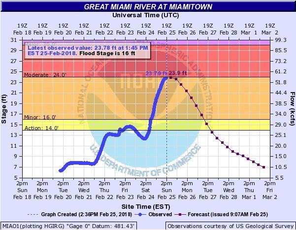
1 SITUATION REPORT: February 2018 Ohio River Flooding Situation Report: #12 Date of Issue: 02/25/2018 Time Issued: 1500 hrs. Prepared By: Samuel O. Reed Approved By: Ryan McEwan Assistant Director Sent to: Hamilton County EOC Team, EMHSA Executive Committee, County Department Heads, Fire, Law Enforcement, Public Works, Chief Elected Officials, Chief Administrators, Neighboring County EMAs, Ohio Watch Desk Executive Summary: Over the last week, prolonged rains along the Ohio River have led to a significant rise in water level. Water levels have risen along the Ohio River and its tributaries including the Great Miami River, Little Miami River, Mill Creek, Muddy Creek and others. A Flood Warning has been issued for Hamilton County by the National Weather Service which continues until further notice. A Flood Watch has also been issued for Hamilton County and is in effect from 1900 hrs. on February 21 until 1000 hrs. on February 25. At 1400 hrs. the Ohio River was at 60.4 ft., which is in the Moderate Flood Stage. The Ohio River level is forecasted to reach 60.7 ft. at 1900 hrs. Sunday evening, which is in the Moderate Flood Stage. Current forecasts anticipate the Ohio River levels to decrease more quickly than originally forecasted. However, the river level is projected to remain in the Moderate Flood Stage until Thursday March 1. With the likelihood of rain Wednesday and Thursday, there is a chance the rivers will not decrease as rapidly as current forecasts indicate. The Great Miami River at Miamitown is forecasted to reach 23.9 ft. at 1900hrs on Sunday, which is in the Minor Flood Stage. The Whitewater River Gauge at Brookville IN, was at ft. at 1345 hrs. on Sunday, which is in the action stage. The impact of both of these rivers being at elevated levels Sunday will likely lead to increased flooding in Whitewater Township. Additionally, the Little Miami River at Milford crested at ft. at 0545 hrs. on Sunday, which is in the Minor Flood Stage. At 1330 hrs. the Little Miami River at Milford was at ft., which is in the Minor Flood Stage, and is forecasted to continue decline. The rising water levels have resulted in several road closures (see below) and response actions taken by local jurisdictions within Hamilton County. Declaration: Gov. John R. Kasich issued an emergency declaration for 17 counties along the Ohio River and in southern Ohio due to dangerous conditions resulting from severe storms and heavy rain. An emergency declaration allows the governor to use state resources, including activating the National Guard, to help local officials keep Ohioans safe. Impacted counties include Adams, Athens, Belmont, Brown, Clermont, Columbiana, Gallia, Hamilton, Hocking, Jackson, Jefferson, Lawrence, Monroe, Meigs, Muskingum, Scioto and Washington. Hamilton County EOC Status: Emergency Activation Level 2 Situational Awareness & Monitoring Hamilton County EMHSA has been monitoring the river levels closely since last week. Hamilton County EMHSA elevated to Emergency Activation Level 2 Situational Awareness & Monitoring on the afternoon of Friday, February 16, 2018 for the potential of flooding. The Agency has sent notifications ahead of the hazard to the Hamilton County EOC Team, the
2 Executive Committee, all local chief elected officials, chief administrative officials, fire chiefs, police chiefs, and public works directors. The Agency remains in regular contact with the National Weather Service to receive briefings, and has shared information with our neighboring Ohio counties as well as the Ohio EMA. The Agency has notified the American Red Cross of current response actions and has discussed the potential areas where shelters may need to be opened. An event has been created in WebEOC: 2018 February Ohio River Flooding to share information with partners. Situation reports will also be issued daily through Tuesday, February 27. On Monday February 26, the Hamilton County EOC will transition into Emergency Action Level 3 - Partial EOC Activation, from This will be a preparation activation to ensure the county is prepared to support impacted jurisdictions. Current Actions: Hamilton County Stadia & Parking put up flood walls at Paul Brown Stadium on Friday, 02/16. On Sunday, the Greater Cincinnati Water Works Stormwater Management Utility activated flood operations at the Mill Creek Barrier Dam facility. The Ohio Department of Transportation and local public works have closed off roads due current or anticipated flooding (see list below). The City of Cincinnati held a meeting on Tuesday, February 20, 2018 at 1000 hrs. to discuss current response actions being taken by the city and potential actions that may be taken during a more severe flooding event. Hamilton County EMHSA attended the meeting. In addition to the Mill Creek Barrier Dam being closed, the City of Cincinnati closed the Harriet floodgate on Saturday, the Carr Street floodgate on Monday, the Mehring Way floodgate on Tuesday the Ditch floodgate closed on Thursday and the floodgate at Penn and Central on Friday. The City of Cincinnati closed Riverfront Parks on Friday, February 23, 2018 until further notice. In Anderson Township, a small residential area has been cut off due to flooding on Debolt Rd. Anderson Township Fire & Rescue made contact with two families (six individuals) who wished to remain in their homes. The residents have worked with Anderson Township to identify an alternate path to leave the neighborhood if they wish to evacuate. One resident had already left the area no assistance was provided. The American Red Cross has put additional Disaster Action Team (DAT) members on standby for flood responses and has begun identifying potential shelter locations. As of 1252 February 25, there were six calls to the American Red Cross for assistance regarding the flooding. At this time a shelter will not be opened, as these will be treated on an individual case-by-case basis. At 2247 hrs. on Saturday, February 24 Cincinnati Dispatch informed the Hamilton County Duty Officer that Cincinnati Dispatch had been receiving an increase in calls regarding water rescues on the east side of Cincinnati in the Columbia Parkway area. At 2318 on Saturday, February 24, 2018, the Hamilton County EMHSA activated the Warning Room to monitor impacts to the County from flooding and severe weather. At 0000 hrs. on Sunday, February 25, 2018 the Hamilton County Communications Center informed the Agency that the retention dam located near Creek and Thornview will potentially flood overnight which may prompt a mandatory evacuation. Per Sharonville Mayor Kevin Hardman, if evacuation became necessary, the community center would be made available for temporary shelter. At 0226 Sunday Morning,

3 Sharonville updated that since the rain has stopped and the dam had receded a few feet, they do not believe the water level will breach the dam. Additionally, at 0225 on February 25, 2018 Hamilton County Communication Center informed the Agency that Debolt and Turpin Road in Newtown were experiencing high water. Officers were going door to door on Turpin to evacuate residents. As of 0153 Winton Woods campground was also being evacuated. Remaining campers were being moved to Meadowlinks Gold Academy. There were no resources requests from any of the aforementioned impacts. Hamilton County EMHSA deactivated the Warning Room at 0326 hrs. on Sunday, February 25, The Hamilton County EMHSA is working with all impacted jurisdiction to understand the impacts to the county. The agency is conducting windshield surveys in known impacted areas on Sunday to understand the extend of the damage. On Sunday, the Agency is requesting local jurisdictions complete damage assessment forms. Potential Hazards: Weather: This afternoon Cloudy, then gradually becoming mostly sunny, with a high near 51. West wind 10 to 13 mph. Tonight Partly cloudy, with a low around 34. West wind around 6 mph becoming calm in the evening. Though advised against it, Hamilton County residents may attempt to drive through flooded roadways which may lead to rescue operations. Flood waters pose a risk for infectious disease, chemical hazards and additional injuries from debris. Flood waters may also put a strain on treatment plants and water distribution systems. Saturation of roadways may lead to roads remaining closed even after the water recedes. The prolonged rainfall increases the likelihood of the potential risk for landslides especially along Columbia Parkway, Eastern Ave, and hillsides. As of this morning there have been four landslides reported from either first responders and open source media at Martin Drive at Paradrome, 1700 Block of Tennessee, 5450 Beechmont and Ross Avenue in Norwood between Section and Reading.
4 Incident Information: Life Safety: Fatalities: No fatalities reported Casualties: No casualties reported Infrastructure: Road Closures: All streets that run south of Kellogg Ave. between Stanley and Salem are closed Apple Hill Road between Kellogg and Salem Road Anderson Ferry is closed off from the railroad tracks to the river Bayou at Riverside is now closed. Brown Rd. and Baab Alley Columbia Parkway between Delta and William Howard Taft Carr Street is closed north of Mehring Way Debolt Rd. at Center St. is closed. Debolt Rd. at Clear Creek Dooley By-Pass near Spring Grove Avenue Eastbound US 52 Ramp to Kellogg Road (near Five Mile) Eastbound Kellogg Ramp to US 52 East Eight Mile Rd. between Kellogg and 275 Eight Mile & Old Kellogg Road Fields Ertel Road, from Route 42 to Village Woods Drive Fletcher off SR126 is closed due to flooding, Link off SR126 is closed due to flooding, and East Kemper between twightwee and Loveland is closed due to flooding, as of 10:30 PM on Saturday. Four Mile Rd. between I-275 Overpass and Kellogg I-275 Northbound Ramp at Exit 72 to Kellogg Road (US 52) near Coney Island (NO ACCESS TO LOWER SALEM AREA OR CALIFORNIA NEIGHBORHOOD FROM I-275 NORTH) I-75 Southbound collector ramp to northbound I-75 is closed due to high water. Idaho Street Kellogg Avenue exit ramp from eastbound State Route 52 closed. Also, eastbound State Route 52 ramp off of Kellogg closed all due to flooding, as of 1:45am on Sunday. Kellogg Avenue from Four Mile Road in Anderson Township to Interstate 275 exit #72. Kellogg Ave. between Wilmer and Apple Hill including Salem intersection. No access to downtown from Salem. Kellogg Ave between Wilmer and Delta is closed. Kellogg Rd. east of Sutton Rd. to Five Mile Rd. o Belterra Park Gaming Closed Kibby Lane and Gracely Dr. in Saylor Park Kilby Rd between US 50 and Suspension Bridge Rd. Lakeridge Drive in Springfield Township Lakeview Dr. in Springfield Township is closed Lawrenceburg between Miamiview and US 50 Lawrenceburg Road between from Suspension Bridge Road to Miamiview Road in Whitewater Township Lawrenceburg Road between U.S. 50 and Miamiview Road in Whitewater Township Lower River Road in Cleves
5 Martin Drive at Paradrome in Mount Adams Mead Ave. and Congress Ave. Closed Mehring, between Central Avenue and Elm Street Mehring from Central Avenue to Main Street Mehring, between Gest Street and Freeman Avenue Mehring Way, from the Sixth Street Viaduct to Freeman Avenue Mile Road in Springfield Township Ross Avenue in Norwood, between Section and Reading Roundbottom Road, from Newtown corporation line to Newtown Farm market SR-32 is closed at Beechmont Avenue and between Clough Pike and Turpin Lane Salem Road closed at Kellogg Ave Salem between Kellogg & Wayside Road South Bound Wilmer (heading towards Kellogg) is now diverted to West Bound Airport Rd. Southbound Wilmer Avenue at Airport Road Southshore Drive in Springfield Township. Southside Ave at Idaho Street Streets that run south off Kellogg Av. in California Ohio have high water boards in place and placed strategically. Suspension Bridge Rd between Kilby Rd and Lawrenceburg Rd Sutton between Kellogg and Two Mile (No Access from Sutton to I-275) Tennessee Avenue at Reading Road Thornton Avenue in Fernbank Park Turpin Lane US 52 ramp East to Northbound 275 in California is now under water. There is no access from US 52 in California heading north on 275 or coming from Northbound 275. No access to lower Salem Area or California neighborhood to I-275 North. West Park Road in Springfield Township Wool Street is now blocked off, it runs between Strader and Delta. (side street) Utility Outages: No significant outages reported Sewer: As of 1138 the morning of Sunday February 25, 2018 From 1207 Saturday February 24, MSD reported 211 SBU calls for service through 1129 Sunday Febraury are currently awaiting dispatch. As many as 20 plus crews may report throughout the day. Wastewater Treatment Update: As of the morning of Sunday February 25, 2018 Plants are operating to capacity. Mill Creek is pumping sludge to holding tanks due to overload (increase mud, sand etc.). The flood walls were not installed at Little Miami as had been planned, just barricades, staff and trucks have been able to get around them so hauling will begin tomorrow as normal. (no hauling on Sunday). They are coordinating with Ohio EPA to address any potential issues.

6 Damage Assessment: Individual Assistance: The City of Cincinnati is reporting no substantial damaged residential homes. There were 10 to 12 houses who experienced water in the basements. A few commercial structures had water in business levels. Damage Assessment information is being complied. Public Assistance: No damage assessments requested at this time Mass Care: Open Cases: No open mass care cases Sheltering: No requests for mass care shelters Feeding: No requests for feeding Resource Support: No requests at this time Attachments: See next.

7

8 For the current river forecasts please visit:
SITUATION REPORT: February 2018 Ohio River Flooding
 SITUATION REPORT: February 2018 Ohio River Flooding Situation Report: #10 Date of Issue: 02/24/2018 Time Issued: 1500 hrs. Prepared By: Samuel O. Reed Approved By: Ryan McEwan Assistant Director Sent to:
SITUATION REPORT: February 2018 Ohio River Flooding
 SITUATION REPORT: February 2018 Ohio River Flooding Situation Report: #15 Date of Issue: 02/27/2018 Time Issued: 1000 hrs. Prepared By: Emily Johnson Community Outreach Specialist Approved By: Ryan McEwan
SITUATION REPORT: February 2018 Ohio River Flooding
 SITUATION REPORT: February 2018 Ohio River Flooding Hamilton County Emergency Management Situation Report: #28 Date of Issue: 03/06/2018 Time Issued: 1400 hrs. Prepared By: Irvin Jones Approved By: Ryan
SITUATION REPORT: February 2018 Ohio River Flooding
 SITUATION REPORT: February 2018 Ohio River Flooding Situation Report: #21 Date of Issue: 03/02/2018 Time Issued: 1030 hrs. Prepared By: Samuel O. Reed Training & Exercise Specialist Approved By: Ryan McEwan
SITUATION REPORT: February 2018 Ohio River Flooding
 SITUATION REPORT: February 2018 Ohio River Flooding Hamilton County Emergency Management Situation Report: #23 Date of Issue: 03/03/2018 Time Issued: 1000 hrs. Prepared By: Emily Johnson Community Outreach
SITUATION REPORT: February 2018 Ohio River Flooding
 SITUATION REPORT: February 2018 Ohio River Flooding Hamilton County Emergency Management Situation Report: #25 Date of Issue: 03/04/2018 Time Issued: 0930 hrs. Prepared By: Morgan Peterson Planning Specialist
Flood Scenario Worksheet
 Flood Scenario Worksheet Scenario adapted from: http://www.epa.gov/watersecurity/tools/trainingcd/simple/source/scenario-8/ssc8-0.pdf Simple Tabletop Exercise, Interdependency Natural Disaster Scenario,
AASHTO Committee on Maintenance 2018 Annual Meeting July 25, Hurricane Irma- Preparation and Response
 AASHTO Committee on Maintenance 2018 Annual Meeting July 25, 2018 Hurricane Irma- Preparation and Response Rudy Powell Director, Office of Maintenance Satellite Aerial Image (September 10, 2017) Hurricane
Daily Operations Briefing Wednesday, April 5, :30 a.m. EDT
 Daily Operations Briefing Wednesday, April 5, 2017 8:30 a.m. EDT Significant Activity Apr 4-5 Significant Events: Severe Weather Southern Plains to Southeast Significant Weather: Severe thunderstorms &
SITUATION REPORT #7 September 8 th, 2017
 MCO AIRPORT EMERGENCY OPERATIONS CENTER SITUATION REPORT #7 September 8 th, 2017 STATE OF FLORIDA REGION V FEMA REGION IV GENERAL INFORMATION Local State of Emergency Declaration Number: 17-235 Dated:
September 13, 2018 MEDIA RELEASE. Waynesboro Department of Emergency Management Waynesboro Police Department Waynesboro Fire Department
 MEDIA RELEASE September 13, 2018 The City continues to prepare for and monitor the track and potential impacts of Hurricane Florence. Current guidance from the National Weather Service, the National Hurricane
Daily Operations Briefing Saturday, June 4, :30 a.m. EDT
 Daily Operations Briefing Saturday, June 4, 2016 8:30 a.m. EDT Significant Activity: June 3-4 Significant Events: Flooding Texas Tropical Activity: Atlantic: Tropical Storm Bonnie Disturbance 1 Pacific:
photo courtesy of
 BRITISH VIRGIN ISLANDS REPORT TROPICAL STORM JEANNE photo courtesy of www.bviplatinum.com PREPARED BY THE DEPARTMENT OF DISASTER MANAGEMENT 1 EVENT 13 th -16 th September, 2004 TROPICAL STORM JEANNE Sequence
WINTER STORM Annex II
 WINTER STORM Annex II I. PURPOSE A. This annex has been prepared to ensure a coordinated response by state agencies to requests from local jurisdictions to reduce potential loss of life and to ensure essential
A Prepared Marylander Creates a Resilient Maryland
 Maryland Emergency Management Agency Operations Directorate Hazardous Winter Weather Outlook Briefing March 5, 2013 0800 A Prepared Marylander Creates a Resilient Maryland A strong low pressure will track
The Sunland Park flyover ramp is set to close the week of March 19 until early summer
 March 2, 2018 The Sunland Park flyover ramp is set to close the week of March 19 until early summer GO 10 is targeting the week of March 19 to close the Sunland Park Drive flyover entrance ramp to I 10
Tropical Update. 5 AM EDT Tuesday, September 12, 2017 Post-Tropical Cyclone Irma, Hurricane Jose, & Tropical Wave (10%)
") Tropical Update 5 AM EDT Tuesday, September 12, 2017 Post-Tropical Cyclone Irma, Hurricane Jose, & Tropical Wave (10%) This update is intended for government and emergency response officials, and is provided
Tropical Update 5 AM EDT Tuesday, September 12, 2017 Post-Tropical Cyclone Irma, Hurricane Jose, & Tropical Wave (10%) This update is intended for government and emergency response officials, and is provided
Daily Operations Briefing. Friday, May 5, :30 a.m. EDT
 Daily Operations Briefing Friday, May 5, 2017 8:30 a.m. EDT Significant Activity May 4-5 Significant Events: Flooding Southern/Central Plains Significant Weather: Flash flooding possible Mid-Atlantic through
Hydrologic Briefing Tropical Storm Harvey
 Hydrologic Briefing Tropical Storm Harvey 5:00 PM CDT Sunday, August 27, 2017 Prepared by: Jennifer Dunn/Christina Barron NWSCorpus www.weather.gov/corpuschristi Situation Overview Tropical Storm Harvey
OXFORD HEIGHTS SUBDIVISION EMERGENCY EVACUATION PLAN
 OXFORD HEIGHTS SUBDIVISION EMERGENCY EVACUATION PLAN March 27, 2007 Oxford Heights Overview and Historical Conditions Oxford Heights is a medium sized community located on the southern side of Elizabeth
SITUATION REPORT. Hurricane Nate. Operational Period: October 8, to October 9,
 SITUATION REPORT Hurricane Nate Operational Period: October 8, 2017 0800 to October 9, 2017 0759 CURRENT SITUATION 2:00 p.m. Briefing Hurricane Nate WEATHER SUMMARY All watches and warnings discontinued.
Press Release. March 12, 2018
 COUNTY EXECUTIVE OFFICE 105 E. Anapamu St., Fourth Floor, Santa Barbara CA 93101 (805) 568-3400 FAX (805) 568-3414 Contact: Santa Barbara County Joint Information Center 805-696-1188 Media Only Press Release
Hydrologic Briefing Tropical Storm Harvey
 Hydrologic Briefing Tropical Storm Harvey 10:30 AM CDT Sunday, August 27, 2017 Prepared by: John Metz NWSCorpus www.weather.gov/corpuschristi Situation Overview Tropical Storm Harvey Harvey to remain a
IWT Scenario 2 Integrated Warning Team Workshop National Weather Service Albany, NY October 31, 2014
 IWT Scenario 2 Integrated Warning Team Workshop National Weather Service Albany, NY October 31, 2014 09 10 11 12 13 Scenario 2 Timeline December 9-13 Tue Wed Thu Fri Sat Tue, Dec. 9 @ 5 am 2014 2014 2014
Tropical Update. 5 PM EDT Tuesday, September 5, 2017 Hurricane Irma, Tropical Storm Jose, and Tropical Depression Thirteen
 Tropical Update 5 PM EDT Tuesday, September 5, 2017 Hurricane Irma, Tropical Storm Jose, and Tropical Depression Thirteen This update is intended for government and emergency response officials, and is
Trainee Manual C02 CITY OF SASKATOON. Water and Sewer Section. Severe Storm Response Trainee Manual. Version # 1-0-3
 Trainee Manual C02 CITY OF SASKATOON Water and Sewer Section Severe Storm Response Trainee Manual CITY OF SASKATOON Severe Storm Response Trainee Manual City of Saskatoon Severe Storm Response Trainees
Daily Operations Briefing Thursday, April 6, :30 a.m. EDT
 Daily Operations Briefing Thursday, April 6, 2017 8:30 a.m. EDT Significant Activity Apr 5-6 Significant Events: Severe Weather Southeast and Mid-Atlantic Significant Weather: Severe thunderstorms possible
Daily Operations Briefing Tuesday, May 31, :30 a.m. EDT
 Daily Operations Briefing Tuesday, May 31, 2016 8:30 a.m. EDT Severe Weather and Flooding - Texas Current Situation: Beginning May 26 and continuing, heavy rain continues over Southern Plains 10 inches
TRAFFIC ALERT FOR WEEK OF February 4 8, 2008
 TRAFFIC ALERT FOR WEEK OF February 4 8, 2008 Highway work zones in the Staunton District The following is a list of highway work that might affect traffic in the Staunton transportation district during
Situation Report KC#56896 Winter Storm 3/13-15/2017 Pennsylvania Emergency Management Agency
 Situation Report KC#56896 Winter Storm 3/13-15/2017 Pennsylvania Emergency Management Agency Report as of 14 Mar 2017 at 1000 hours Situation Report #03 *Changes indicated in Blue Contents: I. Incident
SITUATION REPORT # 7 NEW JERSEY STATE EMERGENCY OPERATIONS CENTER October 29, 2012, 8:00 A.M.
 SITUATION REPORT # 7 NEW JERSEY STATE EMERGENCY OPERATIONS CENTER October 29, 2012, 8:00 A.M. A. CURRENT SYNOPSIS: The NJ ROIC and NJOEM are responding to the onset of Tropical force winds from Hurricane
IWT Scenario 1 Integrated Warning Team Workshop National Weather Service Albany, NY October 31, 2014
 Integrated Warning Team Workshop National Weather Service Albany, NY October 31, 2014 23 24 25 26 27 Scenario 1 Timeline November 23-27 Sun Mon Tue Wed Thu Thanksgiving Day Sunday, Nov. 23 @ 430 pm NWS
A HURRICANE IS COMING. Presented by Atiba Upchurch Broward Emergency Management Division
 A HURRICANE IS COMING Presented by Atiba Upchurch Broward Emergency Management Division Mission Statement To safeguard the lives and property of the people of Broward County from major hazards and emergencies
Daily Operations Briefing Wednesday, February 8, :30 a.m. EST
 Daily Operations Briefing Wednesday, February 8, 2017 8:30 a.m. EST Significant Activity Feb 7-8 Significant Events: Severe weather/tornadoes - Louisiana Significant Weather: Freezing rain possible Pacific
Dunn County Snow Removal Policy
 Dunn County Snow Removal Policy OVERVIEW With the advent of another winter season in the northern plains comes the possibility of snow, freezing rain and slippery roadways, and area resident s concern
Atlantic Basin Satellite Image
 Tropical Update 11 AM EDT Friday, September 7, 2018 Tropical Depression Gordon, Tropical Storm Florence, Potential Tropical Cyclone #8 (90%), Invest 92L (90%) This update is intended for government and
Southern California Edison ESRB-8 Report Regarding Pro-Active De-Energization Event December 29 to January 1, 2019
 Southern California Edison Submitted to: California Public Utilities Commission Director of the Safety and Enforcement Division January 15, 2019 Southern California Edison (SCE) submits the following report
FLOOD/SCS EVENT, APRIL 28 MAY 4
 REPORT DATE: May 4, 2017 EVENT DATE: April 28-May 4, 2017 FLOOD/SCS EVENT, APRIL 28 MAY 4 Event Summary General Significant Flood Outlook. SOURCE: National Weather Service. A significant severe thunderstorm
Daily Operations Briefing. Friday, June 20, :30 a.m. EDT
 Daily Operations Briefing Friday, June 20, 2014 8:30 a.m. EDT Significant Activity: June 19 20 Significant Events: Severe Weather/Flooding Upper Midwest Tropical Activity: Atlantic Area 1 Low (10%) Eastern
Table-Top Exercise for Emergency Preparedness Evaluation: Little Anse, Isle Madame
 Table-Top Exercise for Emergency Preparedness Evaluation: Little Anse, Isle Madame Alexander Chung, M.Sc. Candidate C-Change Student Research Associate May 2013 The Community of Little Anse Coastal community
Monday, May 28, :30 a.m. EDT
 Monday, May 28, 2018 8:30 a.m. EDT Significant Activity May 27-28 Significant Events: Subtropical Storm Alberto; Ellicott City, MD flooding Tropical Activity: Atlantic Subtropical Storm Alberto Significant
Daily Operations Briefing Monday, March 13, :30 a.m. EDT
 Daily Operations Briefing Monday, March 13, 2017 8:30 a.m. EDT Significant Activity Mar 10-13 Significant Events: Nor easter Northeastern U.S. March 13-14 Significant Weather: Heavy snow possible Mid-Atlantic
FLOOD REPORT FOR MANITOBA. June 28, A Gale wind warning is in effect for Lake Manitoba and Lake Winnipeg
 FLOOD REPORT FOR MANITOBA June 28, 2014 A Gale wind warning is in effect for Lake Manitoba and Lake Winnipeg Flood Warning*: Flood Watch*: High Water Advisory*: - Assiniboine River, from Shellmouth Dam
Very Dangerous Coastal Storm Sandy October 28 th 31 st 2012
 Very Dangerous Coastal Storm Sandy October 28 th 31 st 2012 Prepared 600 PM EDT Monday October 29, 2012 Gary Szatkowski NOAA s NJ Forecast Office Weather.gov/phi Purpose of Briefing Briefing #11 for event
National Situation Report As of 5:00 a.m. EDT Tuesday, April 4, 2017
 Overview National Situation Report As of 5:00 a.m. EDT Tuesday, April 4, 2017 Table Of Contents Current Operations Monitoring Recovery National Response Coordination Center: Not Activated National Watch
TXWARN Tabletop Exercise: Hurricane Helen
 TXWARN Tabletop Exercise: Hurricane Helen July 31, 2015 Administrative Details In-studio participants and remote participants Situation manual Evaluations Training hours 1 In Studio: Welcome and Introductions
Thursday, September 27, :30 a.m. EDT
 Thursday, September 27, 2018 8:30 a.m. EDT Significant Activity Sep 26-27 Significant Events: Hurricane Florence Response / Recovery Tropical Activity: Atlantic Tropical Storm Kirk; Disturbance 1: High
CITY OF MINOT SNOW REMOVAL PLAN November 2017
 CITY OF MINOT SNOW REMOVAL PLAN November 2017 1.0 GENERAL This plan has been written to provide information regarding snow removal procedures and policies. The plan provides guidance, while maintaining
Tropical Update. 5 PM EDT Thursday, September 7, 2017 Hurricane Irma, Hurricane Jose, and Hurricane Katia
 Tropical Update 5 PM EDT Thursday, September 7, 2017 Hurricane Irma, Hurricane Jose, and Hurricane Katia This update is intended for government and emergency response officials, and is provided for informational
I-10 East at Redd closes for 24 hours this Sunday, Feb 11. Then, I-10 West at Resler closes for 27 hours on Feb 25
 NEWS RELEASE a TxDOT Project For immediate release EL PASO DISTRICT Jennifer Wright (915) 790-4340 Jennifer.Wright3@txdot.gov February 9, 2018 I-10 East at Redd closes for 24 hours this Sunday, Feb 11
Local Flood Hazards. Click here for Real-time River Information
 Local Flood Hazards Floods of the White River and Killbuck Creek are caused by runoff from general, and/or intense rainfall. Other areas of flooding concern are from the Boland Ditch and Pittsford Ditch.
Daily Operations Briefing Wednesday, July 6, :30 a.m. EDT
 Daily Operations Briefing Wednesday, July 6, 2016 8:30 a.m. EDT Significant Activity: July 5-6 Significant Events: Severe Weather Plains to Ohio Valley Tropical Activity: Atlantic Tropical cyclone activity
Daily Operations Briefing. Saturday, June 21, :30 a.m. EDT
 Daily Operations Briefing Saturday, June 21, 2014 8:30 a.m. EDT Significant Activity: June 20 21 Significant Events: Severe Weather/Flooding Upper Midwest (Final) Tropical Activity: Atlantic Area 1 Low
FLORIDA DIVISION OF EMERGENCY MANAGEMENT STATE WATCH OFFICE DAILY INCIDENT REPORT
 FLORIDA DIVISION OF EMERGENCY MANAGEMENT STATE WATCH OFFICE DAILY INCIDENT REPORT Incident Number: 2018-7477 Incident Name: Woodville Highway Closed Occurred: 12/6/2018 05:29 ET Reported to SWO: 12/6/2018
Wednesday, March 30, 2016
 Total Active DRs 7 Total DRs issued since January 1st 34 Total Number of Shelters Open* 7 (-3) Total Population in Shelters* 143 (-344) Disaster Assessment (Estimated Cumulative) Total: Major + Destroyed:
Daily Operations Briefing. Monday, July 3, :30 a.m. EDT
 Daily Operations Briefing Monday, July 3, 2017 8:30 a.m. EDT Significant Activity June 30-July 3 Significant Events: None Tropical Activity: Atlantic Disturbance 1: High (70%) Eastern Pacific Disturbance
City of Saginaw Right of Way Division Snow and Ice Removal Policy January 18, 2016
 Snow and Ice Removal Policy January 18, 2016 It is the policy of the to provide snowplowing and ice removal services in order to: Provide safe traveling conditions for motorists and pedestrians Assist
Tuesday, May 29, :30 a.m. EDT
 Tuesday, May 29, 2018 8:30 a.m. EDT Significant Activity May 25-29 Significant Events: Subtropical Depression Alberto; Flooding Ellicott City, MD; Kīlauea Volcano Tropical Activity: Atlantic Subtropical
Tuesday, March 5, :30 a.m. EST
 Tuesday, March 5, 2019 8:30 a.m. EST Significant Activity Mar 4-5 Significant Events: Severe thunderstorms and tornadoes AL and GA Tropical Activity: No activity affecting U.S. interests Significant Weather:
Massachusetts Department of Public Health Emergency Preparedness Bureau. August 27, hrs
 Massachusetts Department of Public Health Emergency Preparedness Bureau August 27, 2011 1500 hrs Health and Medical Situational Awareness Report: Hurricane Irene Situational Awareness Report: Hurricane
May 31, Flood Response Overview
 May 31, 2013 Flood Response Overview Suppression 867 Personnel on three (3) shifts 289 Red Shift (A) 289 Blue Shift (B) 289 Green Shift (C) Department Overview Department Overview EMS: 40,934 False Alarm:
CITY OF MINOT SNOW REMOVAL PLAN October 2018
 CITY OF MINOT SNOW REMOVAL PLAN October 2018 1.0 GENERAL This plan has been written to provide information regarding snow removal procedures and policies. The plan provides guidance, while maintaining
Colorado Front Range Wildfires Situation Report #7 Monday, July 02, :15 AM (MDT)
") Colorado Front Range Wildfires Situation Report #7 Monday, July 02, 2012 10:15 AM (MDT) Mandatory evacuations for the Waldo Canyon fire have been reduced from 35,000 to 3,000. Remaining evacuations are
Colorado Front Range Wildfires Situation Report #7 Monday, July 02, 2012 10:15 AM (MDT) Mandatory evacuations for the Waldo Canyon fire have been reduced from 35,000 to 3,000. Remaining evacuations are
Daily Operations Briefing Wednesday, May 3, :30 a.m. EDT
 Daily Operations Briefing Wednesday, May 3, 2017 8:30 a.m. EDT Significant Activity May 2-3 Significant Events: Flooding Southern/Central Plains Significant Weather: Severe thunderstorms possible Southern
Daily Operations Briefing Sunday, July 24, :30 a.m. EDT
 Daily Operations Briefing Sunday, July 24, 2016 8:30 a.m. EDT Central Pacific Tropical Storm Darby http://www.prh.noaa.gov/cphc/ Tropical Storm Darby: (Advisory #51 as of 5:00 a.m. EDT) Located 145 miles
Daily Operations Briefing. Friday, September 19, :30 a.m. EDT
 Daily Operations Briefing Friday, September 19, 2014 8:30 a.m. EDT Significant Activity: Sep 19 20 Significant Events: CA & OR Wildfires Southwest flooding (FINAL) Tropical Activity: Atlantic Tropical
Daily Operations Briefing Friday, November 11, :30 a.m. EST
 Daily Operations Briefing Friday, November 11, 2016 8:30 a.m. EST Significant Activity Nov 10-11 Significant Events: None Tropical Activity: Atlantic Tropical cyclone activity is not expected during the
PUBLIC SAFETY POWER SHUTOFF POLICIES AND PROCEDURES
 PACIFIC GAS AND ELECTRIC COMPANY PUBLIC SAFETY POWER SHUTOFF POLICIES AND PROCEDURES SEPTEMBER 2018 1 PACIFIC GAS AND ELECTRIC COMPANY PUBLIC SAFETY POWER SHUTOFF POLICIES AND PROCEDURES SEPTEMBER 2018
Hurricane Harvey: SE Texas Impacts. 10 AM CDT UPDATE Saturday, August 26, 2017 Prepared by: Dan Reilly, Brian Kyle
 Hurricane Harvey: SE Texas Impacts 10 AM CDT UPDATE Saturday, August 26, 2017 Prepared by: Dan Reilly, Brian Kyle Latest Observations and Radar Hurricane Harvey centered near Victoria and weakening Wind
Daily Operations Briefing. Saturday, March 3, :30 a.m. EST
 Daily Operations Briefing Saturday, March 3, 2018 8:30 a.m. EST Northeast Coastal Storm Situation A high-impact and long duration coastal storm is bringing area of heavy rain and snow, significant coastal
Minto, Mapleton, Huron communities contend with dangerous flood levels Friday
 Minto, Mapleton, Huron communities contend with dangerous flood levels Friday NEWS Jun 28, 2017 by Kelsey Dunbar Wingham Advance Times SHARE - Kelsey Dunbar/ Metroland Media photo - Mike Wilson/ Metroland
Severe Storm Response Version # 1-0-1
 Severe Storm Response Version # 1-0-1 Weather Warnings Environment Canada issues severe weather warnings, watches and advisories Weather Watch Severe weather may develop. Weather Warning Severe weather
Daily Operations Briefing Friday, January 13, :30 a.m. EST
 Daily Operations Briefing Friday, January 13, 2017 8:30 a.m. EST Significant Activity Jan 12-13 Significant Events: Heavy precipitation - western U.S. FINAL Winter storm central U.S. Significant Weather:
Region IX Daily Situational Awareness Report (DSAR) As of 0900 PDT, Monday, October 05, 2015
 As of 0900 PDT, Monday, October 05, 2015") Region IX Daily Situational Awareness Report (DSAR) As of 0900 PDT, Monday, October 05, 2015 For Official Use Only (FOUO) by the employees of the Federal Emergency Management Agency and other agencies
Region IX Daily Situational Awareness Report (DSAR) As of 0900 PDT, Monday, October 05, 2015 For Official Use Only (FOUO) by the employees of the Federal Emergency Management Agency and other agencies
Hurricane Sandy October 28 th 31 st 2012
 Hurricane Sandy October 28 th 31 st 2012 Prepared 530 PM EDT Saturday October 27, 2012 Gary Szatkowski NOAA s NJ Forecast Office Weather.gov/phi Purpose of Briefing Briefing #7 for event Promote situational
Tropical Update. 5 PM EDT Sunday, September 10, 2017 Hurricane Irma, Hurricane Jose, Tropical Wave (60%)
") Tropical Update 5 PM EDT Sunday, September 10, 2017 Hurricane Irma, Hurricane Jose, Tropical Wave (60%) This update is intended for government and emergency response officials, and is provided for informational
Tropical Update 5 PM EDT Sunday, September 10, 2017 Hurricane Irma, Hurricane Jose, Tropical Wave (60%) This update is intended for government and emergency response officials, and is provided for informational
PW 001 SNOW REMOVAL AND SANDING FOR ROADWAYS AND SIDEWALKS October 6, 2014 (#223-14) Original October 19, 2015; October 15, 2018 Public Works
 Original October 19, 2015; October 15, 2018 Public Works") Policy Statement: The Village of Kitscoty will provide snow and ice control on municipal streets and sidewalks according to determined priorities. Purpose: To provide direction and information to employees
Policy Statement: The Village of Kitscoty will provide snow and ice control on municipal streets and sidewalks according to determined priorities. Purpose: To provide direction and information to employees
RESOLUTION NO INTRODUCTION
 RESOLUTION NO. 0824 A RESOLUTION TO ESTABLISH THIS CITY S SNOW AND ICE CONTROL POLICY DURING WINTER MONTHS, SPECIFICALLY DEFINED AS NOVEMBER THROUGH MARCH. BE IT RESOLVED BY THE CITY COUNCIL OF SOLON,
Daily Operations Briefing Tuesday, April 4, :30 a.m. EDT
 Daily Operations Briefing Tuesday, April 4, 2017 8:30 a.m. EDT Significant Activity Apr 3-4 Significant Events: Severe Weather Southern Plains to Southeast Significant Weather: Severe Thunderstorms and
West Tennessee Construction June 14-21, 2017
 FOR IMMEDIATE RELEASE Wednesday, June 14, 2017 CONTACT: Nichole Lawrence CELL: 731-225-6041 West Tennessee Construction June 14-21, 2017 BENTON COUNTY, I-40 Truck Climbing Lane Wednesday, June 7 through
Weather Briefing Mixed Winter Storm Event February 26-27, 2013
 Weather Briefing Mixed Winter Storm Event February 26-27, 2013 Prepared 1200 PM EST Tuesday, February 26th, 2013 Joe Miketta NOAA s NJ Forecast Office http://www.erh.noaa.gov/phi/ Purpose of Briefing Briefing
Daily Operations Briefing Tuesday, January 6, :30 a.m. EST
 Daily Operations Briefing Tuesday, January 6, 2015 8:30 a.m. EST Significant Activity: Jan 5-6 Significant Events: Flooding Western WA - FINAL Significant Weather: Snow Northern/Central Rockies to Northern/Central
National Situation Report As of 5:00 a.m. EDT Wednesday, April 5, 2017
 Overview National Situation Report As of 5:00 a.m. EDT Wednesday, April 5, 2017 Table Of Contents Current Operations Monitoring Recovery National Response Coordination Center: Not Activated National Watch
Monday, February 25, :30 a.m. EST
 Monday, February 25, 2019 8:30 a.m. EST Significant Activity Feb 22-25 Significant Events: Severe Weather Tennessee Valley Tropical Activity: No activity affecting U.S. interests Significant Weather: High
CITY OF NEW LONDON WINTER ROAD & SIDEWALK MAINTENANCE POLICY
 CITY OF NEW LONDON WINTER ROAD & SIDEWALK MAINTENANCE POLICY GENERAL The purpose of this policy is to set up acceptable procedures and policies for the winter maintenance of public areas in the City of
Epic Roanoke, Blacksburg snow day halts work, spurs play
 Epic Roanoke, Blacksburg snow day halts work, spurs play The storm left main routes like I-81 and U.S. 220 completely covered into the evening. REBECCA BARNETT The Roanoke Times Liesl Kellam, 6, and brother
Miami-Dade County Overview
 Miami-Dade County Overview 2,000 square miles World s busiest cruise port 2.6 million residents Second busiest US airport for international travelers Gateway to the Caribbean and Latin America Natural
Daily Operations Briefing. Saturday, March 17, :30 a.m. EDT
 Daily Operations Briefing Saturday, March 17, 2018 8:30 a.m. EDT Significant Activity Mar 16-17 Significant Events: None Tropical Activity: Western Pacific No activity affecting U.S. interests Significant
Tropical Update. 1 PM EDT Monday, May 21, 2018 Caribbean Disturbance (20%)
") Tropical Update 1 PM EDT Monday, May 21, 2018 Caribbean Disturbance (20%) This update is intended for government and emergency response officials, and is provided for informational and situational awareness
Tropical Update 1 PM EDT Monday, May 21, 2018 Caribbean Disturbance (20%) This update is intended for government and emergency response officials, and is provided for informational and situational awareness
Sunday, February 24, :30 a.m. EST
 Sunday, February 24, 2019 8:30 a.m. EST Significant Activity Feb 23-24 Significant Events: Severe Weather Tennessee Valley Tropical Activity: Western Pacific Typhoon Wutip (CAT 4) - FINAL Significant Weather:
Hurricane Matthew Threats and Impacts Briefing for Eastern NC
 Hurricane Matthew Threats and Impacts Briefing for Eastern NC October 6 th, 2016 Date/Time Created: 10/6/2016, Noon EDT National Weather Service Newport/Morehead City, NC Hurricane Matthew Key Points Changes
Tropical Update 11 AM EDT Thursday, September 6, 2018 Tropical Depression Gordon, Hurricane Florence, Invest 92L (90%) & African Tropical Wave (50%)
 & African Tropical Wave (50%)") Tropical Update 11 AM EDT Thursday, September 6, 2018 Tropical Depression Gordon, Hurricane Florence, Invest 92L (90%) & African Tropical Wave (50%) This update is intended for government and emergency
Tropical Update 11 AM EDT Thursday, September 6, 2018 Tropical Depression Gordon, Hurricane Florence, Invest 92L (90%) & African Tropical Wave (50%) This update is intended for government and emergency
Incident Status Summary (ICS-209)
") 1. Incident Name: 2. Incident Number: Spillway - DWR Assist 3. Report Version (check one box): Initial X Update Final 7. Current Incident Size or Area Involved (use unit label e.g., Acres, Square Miles
1. Incident Name: 2. Incident Number: Spillway - DWR Assist 3. Report Version (check one box): Initial X Update Final 7. Current Incident Size or Area Involved (use unit label e.g., Acres, Square Miles
Hurricane Florence Operations Report 5:00 PM September 15, 2018
 Hurricane Florence Operations Report 5:00 PM September 15, 2018 SCDOT Operations Mode: Response SEOC Operations Mode: OPCON1 Statewide Summary SCDOT is responding to impacts from Hurricane Florence. Crews
National Situation Report As of 3:00 a.m. EDT, Thursday, September 21, 2017 Table of Contents Current Operations Monitoring Recovery
 25k Overview National Situation Report As of 3:00 a.m. EDT, Thursday, September 21, 2017 Table of Contents Current Operations Monitoring Recovery FEMA Headquarters Status FEMA Region Status NRCC Level
Daily Operations Briefing Sunday, January 8, :30 a.m. EST
 Daily Operations Briefing Sunday, January 8, 2017 8:30 a.m. EST Significant Activity Jan 6-8 Significant Events: Heavy Precipitation forecast to impact CA and NV Significant Weather: Freezing rain Pacific
Daily Operations Briefing. Thursday, March 27, :30 a.m. EDT
 Daily Operations Briefing Thursday, March 27, 2014 8:30 a.m. EDT Significant Activity: Mar 26 27 Significant Events: Mudslide Snohomish County, WA Fire Boston, MA Significant Weather: Slight risk of severe
President s Day Weekend Storm Community Meeting and Workshop April 17, 2017
 President s Day Weekend Storm Community Meeting and Workshop April 17, 2017 Meeting outline 1. Progress update on the City of San Jose s recovery efforts 2. Water district presentation on: Weather situation
Daily Operations Briefing. Thursday, October 26, :30 a.m. EDT
 Daily Operations Briefing Thursday, October 26, 2017 8:30 a.m. EDT Significant Activity Oct 25-26 Significant Events: Response and recovery Tropical Cyclones Harvey, Irma and Maria Tropical Activity: Atlantic
Monday, November 5, :30 a.m. EST
 Monday, November 5, 2018 8:30 a.m. EST Significant Activity Nov 3-5 Significant Events: Tropical Cyclone Yutu Recovery Tropical Activity: Atlantic No new tropical cyclones are expected during the next