Minto, Mapleton, Huron communities contend with dangerous flood levels Friday
|
|
|
- Elwin Simon
- 5 years ago
- Views:
Transcription

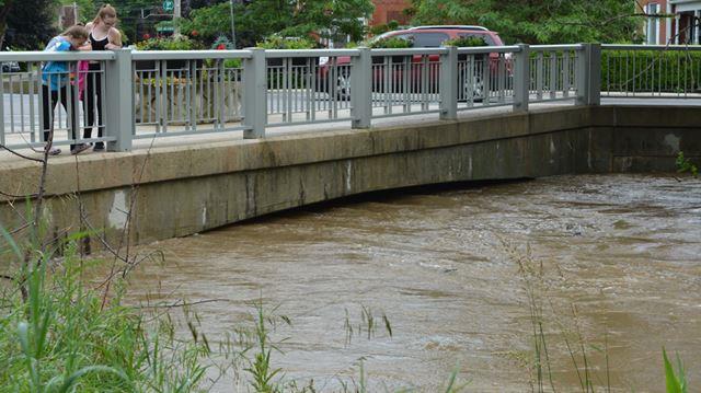
1 Minto, Mapleton, Huron communities contend with dangerous flood levels Friday NEWS Jun 28, 2017 by Kelsey Dunbar Wingham Advance Times SHARE - Kelsey Dunbar/ Metroland Media photo

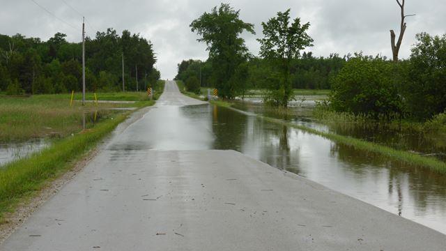
2 - Mike Wilson/ Metroland Media photo

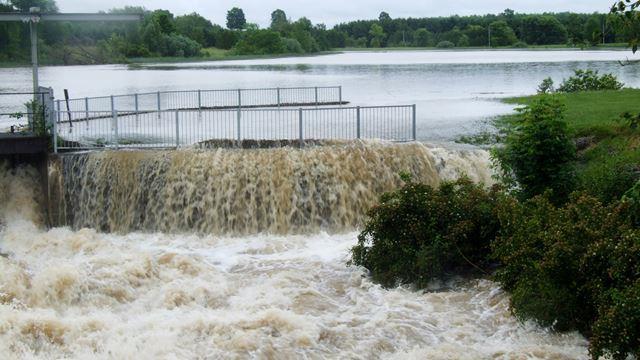
3 - Kelsey Dunbar/ Metroland Media photo
4 - Karen Idzik photo

5 - Jackie Riggs photo
6 SOUTHWESTERN ONTARIO Some say water levels hadn t been as high as they were on Friday, June 23 since Hurricane Hazel in 1954, while others reported that overnight the area received rainfall that exceeded a 100-year event. Maitland Valley Conservation Authority (MVCA) estimated that between 160 and 180 millimetres of rain fell over a 6-8 hour period in the early morning on June 23, creating a state of emergency in the Town of Minto and in the Township of Mapleton. Roads and properties in Wellington North were also flooded. Water levels traveling downstream created issues in the neighbouring communities of Gorrie, Wroxeter, Bluevale and Wingham. The storm traveled inland from Goderich, with Harriston getting the most rainfall, Jayne Thompson, MVCA communications coordinator said in a phone interview with Metroland Media.
7
8 Town of Minto Mayor George Bridge declared a state of emergency Friday morning due to flooding in the areas of Young Street, King Street, Mill Street and George Street in Harriston, where several homes had been evacuated and several rural roads were closed, as they were not passable. The Palmerston District Community Centre was opened for evacuated residents. Minto Fire, the Ontario Provincial Police and public works crews were on scene directing the travelling public around Harriston on Friday and Saturday. Floodwaters in the Town of Minto receded to the Young Street area, trailer park, and flood plain by Saturday morning. Minto Fire assessed several homes and businesses in the communities of Palmerston, Clifford and Harriston that have flooded basements and other areas. Words can t be spoken of how proud I am of our Minto Fire and Town of Minto team for their dedications and professionalism the last two days, Chris Harrow, Minto Fire Chief, stated via Twitter. Thank you to the Minto residents for their support and patience. The unity shown during the flooding was impressive and humbling.
9
10 NEWS Key measurements and estimates control sewage plan Upstream, Wellington North received over 150 mm (or more than 6 inches) of rain in a 24- hour period ending at 8 a.m. on Friday morning. Wellington North Fire Services received five calls related to the flooding on June 23. Most significant was a situation at Spring Valley Park located on Sideroad 5 East 35 people had to be evacuated after being separated on a causeway away from the main park. One child was brought out by the fire department, the rest were able to leave in their own vehicles when the water receded. The other calls related to flooded basements and alarms being tripped. Things happen and we respond accordingly, said WNFS chief Dave Guilbault. The issues (to the south and west) were far greater than what we experienced here. I m proud of how our guys responded to the problems that did arise during the course of the day.
11
12 Downstream from Harriston, the dams in Gorrie, Wroxeter, Bluevale and Wingham faced the dangerous water levels Friday afternoon. Thompson said the North Maitland Watershed carried the bulk of the flow. Midday on June 23, MVCA issued a statement advising the public that there was potential for failure at the Gorrie Dam. MVCA provided mapping of the potential impact of a downstream surge and more than 150 property owners were notified. In Gorrie the dam did what it was designed to do, Thompson said. She explained that the dam was operating at full capacity with water spilling over and into the berm (a flat strip of land, raised bank, or terrace bordering a river or canal). Because it (the dam boards) eroded slowly we didn t see a massive water surge, Thompson said. With the Wroxeter Dam being immediately downstream from Gorrie, community members sprang into action and began pulling boards from the dam upon the potential dam failure statement last Friday. In this emergency event, the Wroxeter dam was operated correctly, Howick Township Deputy Reeve, Robert Clarkson said. Water levels exceeded the height of the boards, not only in Gorrie but also at the Bluevale dam. Thompson said, This occurrence didn t cause significant damage to the dam structures.
13
14 Thompson said the Bluevale area received approximately 90 millimetres of rain. That is still a significant amount of rain, however the forecast only called for 40millimetres of rain, she said. MVCA staff attended the Bluevale dam and adjusted the dam boards on Thursday for the forecasted rainfall. The problem is we didn t get 40 millimetres of rain, Thompson said. In Bluevale the extent of the damage is unknown as water levels are still higher than normal and a tree is resting against the dam, making assessing the damage difficult for MVCA staff. The dams and the conservation areas in Gorrie and Bluevale will be closed to the public for clean up this week. Assessments and any actions moving forward will include the involved municipalities, the Ministry of Natural Resources and Forestry as well as the MVCA. As water levels began to recede in Harriston and flow through Howick Township last weekend, downstream in Wingham, levels continued to slowly rise and peaked Saturday afternoon, flooding the south end of Wingham. North Huron Emergency Services notified approximately 150 property owners in low-lying areas and recommended temporary evacuation of their properties. An evacuation centre was set up at the North Huron Wescast Community Complex in Wingham. No significant property damage occurred and residents who left their homes as part of precautionary measures were safe to return Saturday morning.
15 MVCA previously said in a public statement that this was a 1 in 100-year event, however Thompson said they are seeing this happen more frequently. That statement doesn t mean this will only happen once in 100 years, it could happen tomorrow for all we know, she said. It just means this was the highest in our records in over 100 years. FLOOD RECOVERY EFFORTS Mayor Bridge and Town of Minto staff participated in a conference call with the Ministry of Municipal Affairs regarding disaster relief on June 26. A link to the Ontario Disaster Relief Assistance Program is available on the Town of Minto website for homeowners, small business, small farms and non-profit organizations. The province will first need to deem Minto eligible based on a disaster assessment, the Town of Minto wrote in a media release. To help with this please fill out the form online so the town has a firm number on impacted properties. To participate in the program you will need pictures and receipts; more information is available online at Thompson said MVCA s Watershed Conditions Statement on water safety, issued on June 23, remains in place for all areas of the Maitland Watershed. The public is reminded to exercise caution around all watercourses. Recreational users of the river are advised that flows will remain elevated for several days making activities such as fishing and canoeing unsafe. MVCA recommends avoiding all waterways in the watershed until the end of the week. by Kelsey Dunbar Kelsey Dunbar is a general assignment reporter/photographer with The Wingham Advance-Times. Contact her at kdunbar@wingham.com. Follow her on Twitter and the Advance-Times
MEDIA RELEASE FOR IMMEDIATE RELEASE March 17, 2014 Preparing for the Spring Thaw
 BRACEBRIDGE, ONT Springtime is fast approaching and flooding in low lying areas of the Town is a potential risk due to melting snow and spring rain fall. Flooding can also be experienced during extreme
Chapter 1 The Rain Gauge
 Chapter 1 The Rain Gauge On top of a No Parking sign outside Centennial Middle School in Boulder, Colorado, there is a plastic cylinder. Inside the cylinder is a smaller cylinder with a funnel at the top.
September 13, 2018 MEDIA RELEASE. Waynesboro Department of Emergency Management Waynesboro Police Department Waynesboro Fire Department
 MEDIA RELEASE September 13, 2018 The City continues to prepare for and monitor the track and potential impacts of Hurricane Florence. Current guidance from the National Weather Service, the National Hurricane
Flood Scenario Worksheet
 Flood Scenario Worksheet Scenario adapted from: http://www.epa.gov/watersecurity/tools/trainingcd/simple/source/scenario-8/ssc8-0.pdf Simple Tabletop Exercise, Interdependency Natural Disaster Scenario,
City of Madison Flooding Event AUGUST 20 TH, 2018-PRESENT
 City of Madison Flooding Event AUGUST 20 TH, 2018-PRESENT Presentation Overview Review of Flash Flooding and Flooding from High Lake Levels (August 20 th -Present) Lake Level Information Damages FEMA How
Table-Top Exercise for Emergency Preparedness Evaluation: Little Anse, Isle Madame
 Table-Top Exercise for Emergency Preparedness Evaluation: Little Anse, Isle Madame Alexander Chung, M.Sc. Candidate C-Change Student Research Associate May 2013 The Community of Little Anse Coastal community
FLOOD/SCS EVENT, APRIL 28 MAY 4
 REPORT DATE: May 4, 2017 EVENT DATE: April 28-May 4, 2017 FLOOD/SCS EVENT, APRIL 28 MAY 4 Event Summary General Significant Flood Outlook. SOURCE: National Weather Service. A significant severe thunderstorm
Hurricane Florence: Rain this heavy comes along once every 1,000 years
 Hurricane Florence: Rain this heavy comes along once every 1,000 years By Associated Press, adapted by Newsela staff on 09.17.18 Word Count 786 Level 810L Image 1. This satellite image provided by the
COMMUNITY EMERGENCY RESPONSE TEAM FLOODS INTRODUCTION
 INTRODUCTION Floods are one of the most common hazards in the United States. A flood occurs any time a body of water rises to cover what is usually dry land. Flood effects can be local, impacting a neighborhood
Dunn County Snow Removal Policy
 Dunn County Snow Removal Policy OVERVIEW With the advent of another winter season in the northern plains comes the possibility of snow, freezing rain and slippery roadways, and area resident s concern
SITUATION REPORT #7 September 8 th, 2017
 MCO AIRPORT EMERGENCY OPERATIONS CENTER SITUATION REPORT #7 September 8 th, 2017 STATE OF FLORIDA REGION V FEMA REGION IV GENERAL INFORMATION Local State of Emergency Declaration Number: 17-235 Dated:
FOREST FIRE News July 29, :30
 FOREST FIRE News July 29, 2018 20:30 River Valley Cluster Fire Update ****This will be the last River Valley Cluster Fire Update. In the future, please visit the Ontario.ca/forestfire website for all the
Hurricane Preparation and Recovery. October 11, 2011 Jon Nance, Chief Engineer, NCDOT
 Hurricane Preparation and Recovery October 11, 2011 Jon Nance, Chief Engineer, NCDOT North Carolina & Severe Weather Our state often bears the brunt of storms, which include: Ice storms Snow storms Heavy
FLOOD REPORT FOR MANITOBA. June 28, A Gale wind warning is in effect for Lake Manitoba and Lake Winnipeg
 FLOOD REPORT FOR MANITOBA June 28, 2014 A Gale wind warning is in effect for Lake Manitoba and Lake Winnipeg Flood Warning*: Flood Watch*: High Water Advisory*: - Assiniboine River, from Shellmouth Dam
Managing Floods at Boscastle. Learning Objective: Examine the benefits of managing floods
 Managing Floods at Boscastle Learning Objective: Examine the benefits of managing floods Learning Outcomes: Describe how Boscastle has been affected by flooding Explain strategies to reduce the risk Evaluate
Monitoring Scour Critical Bridges During Floods For Local Bridge Owners. Presented by
 Monitoring Scour Critical Bridges During Floods For Local Bridge Owners Presented by SAFETY FIRST DO NOT ENDANGER YOURSELF OR OTHERS WHILE MONITORING BRIDGES DO NOT ENTER FLOOD WATERS FLOOD WATERS INCLUDE
President s Day Weekend Storm Community Meeting and Workshop April 17, 2017
 President s Day Weekend Storm Community Meeting and Workshop April 17, 2017 Meeting outline 1. Progress update on the City of San Jose s recovery efforts 2. Water district presentation on: Weather situation
Hydrologic Briefing Tropical Storm Harvey
 Hydrologic Briefing Tropical Storm Harvey 5:00 PM CDT Sunday, August 27, 2017 Prepared by: Jennifer Dunn/Christina Barron NWSCorpus www.weather.gov/corpuschristi Situation Overview Tropical Storm Harvey
A HURRICANE IS COMING. Presented by Atiba Upchurch Broward Emergency Management Division
 A HURRICANE IS COMING Presented by Atiba Upchurch Broward Emergency Management Division Mission Statement To safeguard the lives and property of the people of Broward County from major hazards and emergencies
MUNICIPALITY OF ANCHORAGE PUBLIC TRANSPORTATION DEPARTMENT AnchorRIDES TRANSPORTATION SYSTEM
 Purpose: The Public Transportation Department and contracted provider will provide safe transportation for AnchorRIDES customers and employees during severe weather or emergency conditions. AnchorRIDES
Hydrologic Briefing Tropical Storm Harvey
 Hydrologic Briefing Tropical Storm Harvey 10:30 AM CDT Sunday, August 27, 2017 Prepared by: John Metz NWSCorpus www.weather.gov/corpuschristi Situation Overview Tropical Storm Harvey Harvey to remain a
SNOW REMOVAL GUIDE. City Of Orange Township. Public Works Snow Removal Hotline: (973) My Orange Hotline: (973)
 My Orange Hotline: (973)") Mayor Dwayne D. Warren, Esq. And The Orange Municipal Council MOVING ORANGE FORWARD City Of Orange Township SNOW REMOVAL GUIDE Public Works Snow Removal Hotline: (973) 266-4030 My Orange Hotline: (973)
Mayor Dwayne D. Warren, Esq. And The Orange Municipal Council MOVING ORANGE FORWARD City Of Orange Township SNOW REMOVAL GUIDE Public Works Snow Removal Hotline: (973) 266-4030 My Orange Hotline: (973)
HardisonInk.com Normalcy returns to coastal Levy and Dixie counties
 Normalcy returns to coastal Levy and Dixie counties James McCain (left) and Billy Quinn of Cedar Key Water and Sewer Service, check a storm drain pipe. Quinn is replacing the manhole cover here. Story
VISIT MISSISSIPPI GULF COAST CRISIS COMMUNICATION MANUAL 2016
 VISIT MISSISSIPPI GULF COAST CRISIS COMMUNICATION MANUAL 2016 This manual was prepared for Visit Mississippi Gulf Coast staff in the event of a crisis, and will help to distinguish the appropriate course
TOWN OF GRAND FALLS WINDSOR
 TOWN OF GRAND FALLS WINDSOR DEPARTMENT OF ENGINEERING AND WORKS FREQUENTLY ASKED QUESTIONS FOR WINTER OPERATIONS... What streets are the first to be plowed & salted/sanded? The roads crews are each assigned
Snow Cover. Snow Plowing and Removal Services Best Practices Guide. l
 Snow Cover Snow Plowing and Removal Services Best Practices Guide 2015 2016 www.hortica.com l 800.851.7740 During a recent trip to upstate NY, Hortica Loss Control representatives met with several insureds
Floods. Floods COMMUNITY EMERGENCY RESPONSE TEAM FLOODS CONTENT INSTRUCTOR GUIDANCE
 Floods Floods Introduce this topic by explaining that floods are one of the most common hazards in the United States. A flood occurs any time a body of water rises to cover what is usually dry land. Display
FLOOD REPORT FOR MANITOBA. April 11, :00 am
 FLOOD REPORT FOR MANITOBA April 11, 2017 9:00 am Overland flooding and tributary flows are subsiding across much of southern Manitoba. Flows on northern rivers are ice covered and are responding to runoff.
Table G - 6. Mitigation Actions Identified for Implementation by the City of Kent ( ) (From Wilkin County Master Mitigation Action Chart)
 (From Wilkin County Master Mitigation Action Chart)") Table G - 6. Actions Identified by the () (From Master Action Chart) Multi-Hazard Plan, 2017 Action Comments 5 All-Hazards Local Planning & Regulations Update the Operations Plan on an annual basis. Work
Table G - 6. Actions Identified by the () (From Master Action Chart) Multi-Hazard Plan, 2017 Action Comments 5 All-Hazards Local Planning & Regulations Update the Operations Plan on an annual basis. Work
CITY OF NEW LONDON WINTER ROAD & SIDEWALK MAINTENANCE POLICY
 CITY OF NEW LONDON WINTER ROAD & SIDEWALK MAINTENANCE POLICY GENERAL The purpose of this policy is to set up acceptable procedures and policies for the winter maintenance of public areas in the City of
Hurricane Matthew Threats and Impacts Briefing for Eastern NC
 Hurricane Matthew Threats and Impacts Briefing for Eastern NC October 6 th, 2016 Date/Time Created: 10/6/2016, Noon EDT National Weather Service Newport/Morehead City, NC Hurricane Matthew Key Points Changes
Working with Natural Stream Systems
 Working with Natural Stream Systems Graydon Dutcher Delaware County Soil & Water Conservation District Stream Corridor Management Program Tropical Storm Sandy October 29,2012 What is a Watershed?
Winter Weather Safety Tips. From your friends at South Brunswick Township Department of Public Works
 Winter Weather Safety Tips From your friends at South Brunswick Township Department of Public Works South Brunswick Township Department of Public Works is committed to providing timely, efficient, and
SEVERE WEATHER PLAN FOR INSTITUTE OF TECHNOLOGY TALLAGHT
 SEVERE WEATHER PLAN FOR INSTITUTE OF TECHNOLOGY TALLAGHT I. GENERAL A. This plan identifies IT Tallaght s response to severe weather warnings or conditions as experienced on campus or as communicated by
An overview of the applications for early warning and mapping of the flood events in New Brunswick
 Flood Recovery, Innovation and Reponse IV 239 An overview of the applications for early warning and mapping of the flood events in New Brunswick D. Mioc 1, E. McGillivray 2, F. Anton 1, M. Mezouaghi 2,
Belize. UNICEF Belize. Humanitarian Situation Report #1. Situation Overview and Highlights. 252 individuals in shelters
 Belize Humanitarian Situation Report #1 CURRENT SITUATION IN NUMBERS Situation Overview and Highlights Belize City has been the area most affected in the country as an area of low pressure passing over
Hot Calls. Odessa FD: MVA. Burdett FD: MVAs
 Schuyler County Emergenc y M anagement Hot Calls Volume 4, Issue 5 Written by: Rick Churches Send news to: rickshirlc27@gmail.com Odessa FD: MVA September/October 2017 B usy night for OFD as two calls
Residents Emergency Response Checklist
 COMMUNITY RESILIENCE PLAN Residents Emergency Response Checklist A helpful guide in the event of extreme weather or bushfire events. < PREVIOUS I NEXT > 02 Purchasing an existing property or building a
OXFORD HEIGHTS SUBDIVISION EMERGENCY EVACUATION PLAN
 OXFORD HEIGHTS SUBDIVISION EMERGENCY EVACUATION PLAN March 27, 2007 Oxford Heights Overview and Historical Conditions Oxford Heights is a medium sized community located on the southern side of Elizabeth
The Leader in Landscape Solutions
 The Leader in Landscape Solutions Emergency Action Plan Hurricane Preparedness Go To Mainscape.com For More Information! Purpose: To provide the Federation at Kings Point and their residents an informative
SNOW CONTROL OPERATIONS
 SNOW CONTROL OPERATIONS PUBLIC WORKS TEAM STREET MAINTENANCE DIVISION SNOW CONTROL OPERATIONS Standard Operating Procedures for Snow Removal Operations. 1. Plowing operations will be initiated when snow
MUNICIPALITY OF ANCHORAGE PUBLIC TRANSPORTATION DEPARTMENT AnchorRIDES PARATRANSIT SYSTEM
 Purpose: The Public Transportation Department (PTD) and AnchorRIDES paratransit contractor will provide transportation in as safe a manner as effectively possible. Paratransit vehicles primarily operate
FOREST FIRE. News August 15, :00am. Great progress continues to be made extinguishing hot spots on Parry Sound Fire 033.
 FOREST FIRE News August 15, 2018 8:00am Parry Sound 33 Fire Update Great progress continues to be made extinguishing hot spots on Parry Sound Fire 033. Hot weather continues to hold on which has caused
Temporary College Closure Due to Inclement Weather or Other Adverse Conditions.
 OTHER TOPICS Index No. X-1 PROCEDURES MEMORANDUM TO: FROM: SUBJECT: MCC Students and Staff Office of the President Temporary College Closure Due to Inclement Weather or Other Adverse Conditions. DATE:
photo courtesy of
 BRITISH VIRGIN ISLANDS REPORT TROPICAL STORM JEANNE photo courtesy of www.bviplatinum.com PREPARED BY THE DEPARTMENT OF DISASTER MANAGEMENT 1 EVENT 13 th -16 th September, 2004 TROPICAL STORM JEANNE Sequence
Fort Lauderdale s GIS Supports Response to. Hurricane Irma
 Fort Lauderdale s GIS Supports Response to Hurricane Irma By Monica Pratt, ArcUser Editor When Hurricane Irma first made landfall in the Florida Keys on September 10, 2017, it brought destructive 70 mph
ICE STORM! a mini tabletop exercise for home care agencies
 1 ICE STORM! a mini tabletop exercise for home care agencies HCA Education and Research Winter 2010 2011 2 What is a tabletop exercise? People come together to review and discuss a hypothetical emergency
SEVERE WEATHER 101. Flood Basics
 SEVERE WEATHER 101 Flood Basics What is flooding? Flooding is an overflowing of water onto land that is normally dry. Floods can happen during heavy rains, when ocean waves come on shore, when snow melts
USING GIS TO MODEL AND ANALYZE HISTORICAL FLOODING OF THE GUADALUPE RIVER NEAR NEW BRAUNFELS, TEXAS
 USING GIS TO MODEL AND ANALYZE HISTORICAL FLOODING OF THE GUADALUPE RIVER NEAR NEW BRAUNFELS, TEXAS ASHLEY EVANS While the state of Texas is well-known for flooding, the Guadalupe River Basin is one of
CATEX Hurricane Zachary
 CATEX Hurricane Zachary EXERCISE, EXERCISE,EXERCISE East Coast CATEX Power Restoration Functional Exercise 2013 This document was prepared under a grant from FEMA's Grants Programs Directorate, U.S. Department
Significant Flooding Expected
 Significant Flooding Expected Decision Support Briefing #5 As of: 9:00 AM September 14, 2018 What Has Changed? Flash Flood Watch now in effect for part of area, will be expanded later today 9/14/2018 9:23
WINTER STORM Annex II
 WINTER STORM Annex II I. PURPOSE A. This annex has been prepared to ensure a coordinated response by state agencies to requests from local jurisdictions to reduce potential loss of life and to ensure essential
Pre-Disaster Natural Hazard Mitigation Plan Guilford, Connecticut History of Hazard Mitigation Planning Authority Disaster Mitigation Act of 2000 (ame
 Pre-Disaster Natural Hazard Mitigation Plan Guilford, Connecticut History of Hazard Mitigation Planning Authority Disaster Mitigation Act of 2000 (amendments to Stafford Act of 1988) Presented by: David
EXCEPTIONAL CLOSURES - CHECKLIST FOR GOOSTREY COMMUNITY PRIMARY SCHOOL
 EXCEPTIONAL CLOSURES - CHECKLIST FOR GOOSTREY COMMUNITY PRIMARY SCHOOL To be reviewed Spring 2018 It is the policy of Goostrey Community Primary School to remain open unless we are forced to close because
ADMINISTRATIVE PROCEDURES
 PROCEDURES NO: A-AD-109-14 ADMINISTRATIVE PROCEDURES SUBJECT: A. Communications For the purpose of communicating the policies, regulations, administrative procedures, and parental expectations of Transportation
Press Release. March 12, 2018
 COUNTY EXECUTIVE OFFICE 105 E. Anapamu St., Fourth Floor, Santa Barbara CA 93101 (805) 568-3400 FAX (805) 568-3414 Contact: Santa Barbara County Joint Information Center 805-696-1188 Media Only Press Release
Better estimation of Flood Wave Propagation Time in Meandering Reaches by using 2D-modelling
 Better estimation of Flood Wave Propagation Time in Meandering Reaches by using 2D-modelling J. Persson M. Jewert N. Isaksson Norconsult AB, Sweden Norconsult AB, Sweden Fortum Generation AB, Sweden ABSTRACT
NOAA s National Weather Service Philadelphia/Mt. Holly NJ
 Next Briefing Package: Friday, October 2, 2015 no later than 300 PM Hazards and Impacts: Overview: A dangerous weather pattern still threatens our region. Threats include very heavy rainfall, inland river
Keswick flood November 2009
 Keswick flood 2009 As events started to unfold on Thursday 19 no one could have imagined the ferocity and impact this latest deluge would have on the County. The Met Office had issued severe weather warnings
Flood Forecasting Methodology in Alberta
 Flood Forecasting Methodology in Alberta Evan Friesenhan, M.Eng., P.Eng Alberta Environment and Sustainable Resource Development March 17, 2014 River Forecast Team Mandate To provide Albertans with information
Physical landscapes River landscapes in the UK
 Physical landscapes River landscapes in the UK The shape of river valleys change s as rivers flow downstream - PROCESSES Erosion Abrasion or corrasion Attrition Hydraulic Action Solution or corrosion Deposition
Outages.sdrea.coop Outage Map Status at 7 a.m. 14Apr2018:
 Winter Storm Xanto (13April2018-14April2018) Social Media Round Up Unless otherwise noted, all posts are gathered from individual cooperatives Facebook Accounts. Approx. 7:50 a.m. 14Apr2018 Sioux Valley
Trainee Manual C02 CITY OF SASKATOON. Water and Sewer Section. Severe Storm Response Trainee Manual. Version # 1-0-3
 Trainee Manual C02 CITY OF SASKATOON Water and Sewer Section Severe Storm Response Trainee Manual CITY OF SASKATOON Severe Storm Response Trainee Manual City of Saskatoon Severe Storm Response Trainees
Wednesday, March 30, 2016
 Total Active DRs 7 Total DRs issued since January 1st 34 Total Number of Shelters Open* 7 (-3) Total Population in Shelters* 143 (-344) Disaster Assessment (Estimated Cumulative) Total: Major + Destroyed:
Report and recommendations relating to the Severe Flood Event in Selly Park South on 6th September 2008
 Report and recommendations relating to the Severe Flood Event in Selly Park South on 6th September 2008 Compiled for Selly Park South Neighbourhood Forum, Birmingham City Council and the Environment Agency
Dealing with natural disasters
 Ophthalmology news - OPHTHALMOLOGY BUSINESS - Dealing with natural disasters FEBRUARY 2018 OPHTHALMOLOGY BUSINESS Dealing with natural disasters by Vanessa Caceres EyeWorld Contributing Writer Ophthalmologists
City of Saginaw Right of Way Division Snow and Ice Removal Policy January 18, 2016
 Snow and Ice Removal Policy January 18, 2016 It is the policy of the to provide snowplowing and ice removal services in order to: Provide safe traveling conditions for motorists and pedestrians Assist
Appendix A Flood Damages in 2013
 Appendix A Flood Damages in 2013 RPT2-2014-07-09-App_A_Highwood_River_Flood_Damage_In_2013.Docx Table of Contents page Sign-Off 1. Flood Damage in 2013... 1 1.1 Background... 1 1.2 Town of High River...
Tropical Update. 11 AM EDT Wednesday, October 10, 2018 Hurricane Michael, Hurricane Leslie & Tropical Storm Nadine, Caribbean Low (40%)
") Tropical Update 11 AM EDT Wednesday, October 10, 2018 Hurricane Michael, Hurricane Leslie & Tropical Storm Nadine, Caribbean Low (40%) This update is intended for government and emergency response officials,
Tropical Update 11 AM EDT Wednesday, October 10, 2018 Hurricane Michael, Hurricane Leslie & Tropical Storm Nadine, Caribbean Low (40%) This update is intended for government and emergency response officials,
TROPICAL STORM HERMINE AND HURRICANE MATTHEW HI CERT RESPONSE
 AND HURRICANE MATTHEW HI CERT RESPONSE Hermine hit Hatteras Island on Labor Day 2016 High winds, very heavy rain, causing severe flooding from Avon to Hatteras village Avon had 3+ feet of water throughout
H IG HWAY WINTER OPERATIONS SNOW REMOVAL AND ICE CONTROL POLICY. Revised January 4, 2016
 ! H IG HWAY WINTER OPERATIONS SNOW REMOVAL AND ICE CONTROL POLICY Adopted January 11, 2010 Revised January 4, 2016 Pol icy It is the goal and intent of the Town of Sullivan to provide timely, efficient
Response Case Study: April 2014 Historic Flood Event. Severe Weather April 29 30, 2014
 Response Case Study: April 2014 Historic Flood Event NOAA s Regional Preparedness Training (NRPT) Natural Disaster Causing Technology Disasters in Mobile Bay Area Kimberly Albins Gulf of Mexico Regional
Tropical Update 11 AM EDT Thursday, September 6, 2018 Tropical Depression Gordon, Hurricane Florence, Invest 92L (90%) & African Tropical Wave (50%)
 & African Tropical Wave (50%)") Tropical Update 11 AM EDT Thursday, September 6, 2018 Tropical Depression Gordon, Hurricane Florence, Invest 92L (90%) & African Tropical Wave (50%) This update is intended for government and emergency
Tropical Update 11 AM EDT Thursday, September 6, 2018 Tropical Depression Gordon, Hurricane Florence, Invest 92L (90%) & African Tropical Wave (50%) This update is intended for government and emergency
A Simple Procedure for Estimating Loss of Life from Dam Failure. Wayne J. Graham, P.E. 1
 A Simple Procedure for Estimating Loss of Life from Dam Failure Wayne J. Graham, P.E. 1 INTRODUCTION Evaluating the consequences resulting from a dam failure is an important and integral part of any dam
Natural Processes. Were you prepared for the fast approaching storm? Were you able to take shelter? What about pets, livestock or plants?
 Have you ever been caught in a storm? You are outside on a summer night and all of a sudden here come the wind, lightning and heavy rain. It starts raining so hard that you can hardly see in front of you.
CAT-i Bulletin Catastrophe Information
 CAT-i Bulletin Catastrophe Information Report Date: December 28, 2018 Sydney Hailstorms, December 20, 2018 Hail Swath for the Sydney Hail Event. Source: Dr Joshua Soderholm, Monash University, using radar
LA GRANGE FIRE DEPARTMENT
 LA GRANGE FIRE DEPARTMENT MARCH 016 A SERVICE PUBLICATION OF THE LA GRANGE FIRE DEPARTMENT 708-579-8 EVENTS 016 IAFF Local 8 rd Annual Golf Outing May 7, 016 69 th Annual Pet Parade Saturday June 4, 016
Progress Report. Flood Hazard Mapping in Thailand
 Progress Report Flood Hazard Mapping in Thailand Prepared By: Mr. PAITOON NAKTAE Chief of Safety Standard sub-beuro Disaster Prevention beuro Department of Disaster Prevention and Mitigation THAILAND E-mail:
TOWN OF WINDSOR SNOW CONTROL PLAN
 TOWN OF WINDSOR SNOW CONTROL PLAN 2013-2014 Revised 10/30/13 WCS Page 1 TOWN OF WINDSOR SNOW CONTROL PLAN GOAL One of the primary goals of the Public Works Department is to provide for the safe and orderly
CITY OF MINOT SNOW REMOVAL PLAN November 2017
 CITY OF MINOT SNOW REMOVAL PLAN November 2017 1.0 GENERAL This plan has been written to provide information regarding snow removal procedures and policies. The plan provides guidance, while maintaining
ILO Assessment Report: Community Based Emergency Employment Nabulini, Manu and Naibita Village.
 ILO Assessment Report: Community Based Emergency Employment Nabulini, Manu and Naibita Village. Back ground: The category 5 tropical cyclone Winston (TCW) which made landfall in Fiji on 20th February 2016
Tropical Update. 5 PM EDT Thursday, September 7, 2017 Hurricane Irma, Hurricane Jose, and Hurricane Katia
 Tropical Update 5 PM EDT Thursday, September 7, 2017 Hurricane Irma, Hurricane Jose, and Hurricane Katia This update is intended for government and emergency response officials, and is provided for informational
EMERGENCY WARNING SYSTEM PROCEDURES FOR DEBRIS FLOWS IN WESTERN OREGON
 EMERGENCY WARNING SYSTEM PROCEDURES FOR DEBRIS FLOWS IN WESTERN OREGON Updated: 12/03/2007 by the Oregon Department of Forestry and the Oregon Department of Geology and Mineral Industries Debris flows
IWT Scenario 2 Integrated Warning Team Workshop National Weather Service Albany, NY October 31, 2014
 IWT Scenario 2 Integrated Warning Team Workshop National Weather Service Albany, NY October 31, 2014 09 10 11 12 13 Scenario 2 Timeline December 9-13 Tue Wed Thu Fri Sat Tue, Dec. 9 @ 5 am 2014 2014 2014
Flood Forecasting Methodology in Alberta
 Flood Forecasting Methodology in Alberta Evan Friesenhan, M.Eng., P.Eng Alberta Environment and Sustainable Resource Development February 18, 2014 River Forecast Team Mandate To provide Albertans with
Policy and Procedure for Emergency Planning
 Viera Children s Academy 3395 Viera Boulevard Viera, Florida 32940 (321) 4332330 (321) 4332331 fax Policy and Procedure for Emergency Planning Director Signature Date Purpose: To ensure that in the event
STEUBEN COUNTY, NEW YORK. Hazard Analysis Report
 STEUBEN COUNTY, NEW YORK Hazard Analysis Report Prepared by: April 1, 2014 Background On April 1, 2014 the Steuben County Office of Emergency Management conducted a hazard analysis using the automated
Technical Memorandum #2 Future Conditions
 Technical Memorandum #2 Future Conditions To: Dan Farnsworth Transportation Planner Fargo-Moorhead Metro Council of Governments From: Rick Gunderson, PE Josh Hinds PE, PTOE Houston Engineering, Inc. Subject:
Review of August 7, 2018 Storm Event
 Review of August 7, 2018 Storm Event Toronto and Region Conservation Authority August 10, 2018 Executive Committee Presented by: Dan Hipple, P.Eng. Senior Manager, Water Resources Engineering Chief Flood
City of Rhinelander Snow and Ice Policy
 City of Rhinelander Snow and Ice Policy General: Policy: Procedure: The ability to react promptly and decisively to varying winter weather conditions with regard to snow removal and ice control on city
NOAA s National Weather Service Philadelphia/Mt. Holly NJ
 Next Briefing Package: Thursday, October 1, 2015 no later than 300 PM Hazards and Impacts: Overview: A dangerous weather pattern is developing for our region. Threats include very heavy rainfall, inland
WEATHER SYSTEMS IMPACTING THE CAYMAN ISLANDS Prepared by the staff of the Cayman Islands National Weather Service
 WEATHER SYSTEMS IMPACTING THE CAYMAN ISLANDS 2008 Prepared by the staff of the Cayman Islands National Weather Service TROPICAL STORM DOLLY Formed 194 miles west of Grand Cayman July 19 th. The tropical
FOREST FIRE. News August 14, :00am. Parry Sound 33 Fire Update
 FOREST FIRE News August 14, 2018 8:00am Parry Sound 33 Fire Update The Incident Management Team is pleased to advise that all values equipment on the fire has been removed. If you happen to come across
 Red River Flooding June 2015 Caddo and Bossier Parishes Presented by: Flood Technical Committee Where the Rain Falls Matters I-30 versus I-20 I-20 Backwater and Tributary Floods (Localized) 2016 Flood
Severe Storm Response Version # 1-0-1
 Severe Storm Response Version # 1-0-1 Weather Warnings Environment Canada issues severe weather warnings, watches and advisories Weather Watch Severe weather may develop. Weather Warning Severe weather
THE NEED FOR AN ADDITIONAL SPILLWAY AT THE SANFORD DAM BOILING SPRING LAKES, NC. Presentation for The Brunswick County Commissioners April 20, 2015
 THE NEED FOR AN ADDITIONAL SPILLWAY AT THE SANFORD DAM BOILING SPRING LAKES, NC Presentation for The Brunswick County Commissioners April 20, 2015 The Sanford Dam Earth Dam constructed in 1961 Drainage
HURRICANE PRACTICE ACTIVITIES
 HURRICANE PRACTICE ACTIVITIES Practice Dash Divide students into teams of 5-6 for a takeoff on Jeopardy. Explain that you will read an answer and that the student teams will compete by having one team
Snow and Ice Removal
 Policy # 6.6 Procedure # - Replaces 5.10 & 5.10A Revises - Date Approved February 10, 2014 Method of Approval Resolution #17 1. PRINCIPLES The City of Dauphin desires to maintain the City streets, lanes,
FEMA Hurricane Fact Sheet
 PIA Doc. No. 90191 FEMA Hurricane Fact Sheet The information contained within this Resource kit is provided by the Federal Emergency Management Agency and is provided as a PIA member service. To contact
CITY OF MINOT SNOW REMOVAL PLAN JANUARY 2015
 CITY OF MINOT SNOW REMOVAL PLAN JANUARY 2015 1.0 GENERAL This plan has been written to provide information regarding snow removal procedures and policies. The plan provides guidance, while maintaining