SITUATION REPORT: February 2018 Ohio River Flooding
|
|
|
- Verity Parrish
- 5 years ago
- Views:
Transcription


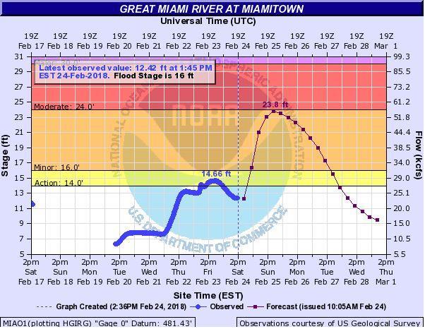
1 SITUATION REPORT: February 2018 Ohio River Flooding Situation Report: #10 Date of Issue: 02/24/2018 Time Issued: 1500 hrs. Prepared By: Samuel O. Reed Approved By: Ryan McEwan Assistant Director Sent to: Hamilton County EOC Team, EMHSA Executive Committee, County Department Heads, Fire, Law Enforcement, Public Works, Chief Elected Officials, Chief Administrators, Neighboring County EMAs, Ohio Watch Desk Executive Summary: Over the last week, prolonged rains along the Ohio River have led to a significant rise in water level. Water levels have risen along the Ohio River and its tributaries including the Great Miami River, Little Miami River, Mill Creek, Muddy Creek and others. A Flood Warning has been issued for Hamilton County by the National Weather Service which continues until further notice. A Flood Watch has also been issued for Hamilton County and is in effect from 1900 hrs. on February 21 until 1000 hrs. on February 25. At 1400 hrs. the Ohio River was at ft., which is in the Moderate Flood Stage. The river level is forecasted to decrease to ft. on Sunday morning at approximately 0100 hrs. The Ohio River is forecasted to reach 59.5 ft. at 0700 hrs. Monday morning, which is in the Moderate Flood Stage. This new river forecast projects the crest almost 24 hours earlier than originally projected. Current forecasts anticipate the Ohio River to remain in the Minor and Moderate Flood Stages for the next several days. The National Weather Service issued an updated briefing regarding the potential for renewed flooding along the Ohio River and its tributaries late Saturday into next week as well as the potential for small stream/lowland flooding from prolonged rainfall through this week into the weekend. The updated briefing also included information on the potential impact of damaging winds west and southwest of metropolitan Cincinnati late Saturday night. Embedded Thunderstorms will be possible Saturday night. Some of the storms may be capable of producing damaging winds after midnight, along with a low end threat for a brief tornado. The approximate time is mainly between midnight-0600 Sunday morning, with the greatest threat within 50 miles of Cincinnati. The confidence in severe storms is fairly low, but slightly higher south and west of metropolitan Cincinnati. The Great Miami River at Miamitown is forecasted to reach 23.8 ft. at 1900hrs on Sunday, which is in the Minor Flood Stage. The Whitewater River Gauge at Brookville IN, is forecasted to reach 15.7 ft. at 0700 hrs. on Sunday, which is in the action stage. The impact of both of these rivers being at elevated levels Sunday into Monday will likely lead to increased flooding in Whitewater Township. The rising water levels have resulted in several road closures (see below) and response actions taken by local jurisdictions within Hamilton County. Additionally, the Little Miami River at Milford is forecasted to reach 18.2 ft. at 0700 hrs. on Sunday, which is in the Minor Flood Stage. Declaration: No declarations have been made at this time.
2 Hamilton County EOC Status: Emergency Activation Level 2 Situational Awareness & Monitoring Hamilton County EMHSA has been monitoring the river levels closely since last week. The Agency has sent notifications ahead of the hazard to the Hamilton County EOC Team, the Executive Committee, all local chief elected officials, chief administrative officials, fire chiefs, police chiefs, and public works directors. The Agency remains in regular contact with the National Weather Service to receive briefings, and has shared information with our neighboring Ohio counties as well as the Ohio EMA. The Agency has notified the American Red Cross of current response actions and has discussed the potential areas where shelters may need to be opened. An event has been created in WebEOC: 2018 February Ohio River Flooding to share information with partners. Situation reports will also be issued daily through Tuesday, February 27. On Monday February 26, the Hamilton County EOC will transition into Emergency Action Level 3 - Partial EOC Activation, from This will be a preparation meeting to ensure the county is prepared to support impacted jurisdictions. Current Actions: Hamilton County Stadia & Parking put up flood walls at Paul Brown Stadium on Friday, 02/16. On Sunday, the Greater Cincinnati Water Works Stormwater Management Utility activated flood operations at the Mill Creek Barrier Dam facility. The Ohio Department of Transportation and local public works have closed off roads due current or anticipated flooding (see list below). In Anderson Township, a small residential area has been cut off due to flooding on Debolt Rd. Anderson Township Fire & Rescue made contact with two families (six individuals) who wished to remain in their homes. The residents have worked with Anderson Township to identify an alternate path to leave the neighborhood if they wish to evacuate. One resident had already left the area no assistance was provided. The American Red Cross has put additional Disaster Action Team (DAT) members on standby for flood responses and has begun identifying potential shelter locations. The Red Cross has not opened any cases for this event. The City of Cincinnati held a meeting on Tuesday, February 20, 2018 at 1000 hrs. to discuss current response actions being taken by the city and potential actions that may be taken during a more severe flooding event. Hamilton County EMHSA attended the meeting. In addition to the Mill Creek Barrier Dam being closed, the City of Cincinnati closed the Harriet floodgate on Saturday, the Carr Street floodgate on Monday, the Mehring Way floodgate on Tuesday the Ditch floodgate closed on Thursday and the floodgate at Penn and Central on Friday. The City of Cincinnati closed Riverfront Parks on Friday, February 23, 2018 until further notice. Potential Hazards: Weather: This Afternoon Showers, mainly after 3pm. High near 53. East wind around 10 mph, with gusts as high as 21 mph. Chance of precipitation is 80%. New precipitation amounts between a tenth and quarter of an inch possible.

3 Tonight Showers and possibly a thunderstorm before 3am, then showers likely. Some of the storms could be severe and produce heavy rainfall. Temperature falling to near 51 by 8pm, then rising to around 63 during the remainder of the night. Breezy, with a southeast wind 8 to 13 mph becoming south 15 to 20 mph after midnight. Winds could gust as high as 36 mph. Chance of precipitation is 100%. New rainfall amounts between 1 and 2 inches possible. Heavier rain not only in Hamilton County but along the Ohio River could mean the estimated river crest could continue to rise. A chance of precipitation continues through Sunday. Hamilton County is currently under a High Risk for excessive rain through tonight, which is over a 50% chance of exceeding flash flood guidance within 25 miles of a point to the right of a line. Heavy rain on top of already-saturated soils may lead to quick rises of water. The Weather Prediction Center forecasts Hamilton County may receive approximately 1.25 to 1.75 inches of rainfall from 0700 hrs. Saturday through 0700 hrs. Sunday. Though advised against it, Hamilton County residents may attempt to drive through flooded roadways which may lead to rescue operations. Flood waters pose a risk for infectious disease, chemical hazards and additional injuries from debris. Flood waters may also put a strain on treatment plants and water distribution systems. Saturation of roadways may lead to roads remaining closed even after the water recedes. The prolonged rainfall increases the likelihood of the potential risk for landslides especially along Columbia Parkway, Eastern Ave, and hillsides. Incident Information: Life Safety: Fatalities: No fatalities reported Casualties: No casualties reported Infrastructure: Road Closures: Mehring Way between 6 th and Freeman & Mehring Way from Central to Elm is closed Lawrenceburg between Miamiview and US 50 SR-32 is closed at Beechmont Avenue and between Clough Pike and Turpin Lane Salem Road closed at Kellogg Ave Salem between Kellogg & Wayside Road Eight Mile & Old Kellogg Road
4 Sutton between Kellogg and Two Mile (No Access from Sutton to I-275) All streets that run south of Kellogg Ave. between Stanley and Salem are closed Streets that run south off Kellogg Av. in California Ohio have high water boards in place and placed strategically. Kellogg Rd. east of Sutton Rd. to Five Mile Rd. o Belterra Park Gaming Closed Kellogg Ave. between Wilmer and Apple Hill Kellogg Ave between Wilmer and Delta is closed. South Bound Wilmer (heading towards Kellogg) is now diverted to West Bound Airport Rd. Carr Street is closed. Eight Mile Rd. between Kellogg and 275 Four Mile Rd. between I-275 Overpass and Kellogg Kellogg Avenue from Four Mile Road in Anderson Township to Interstate 275 exit #72. I-275 ramps to and from Kellogg Ave. are now closed. Debolt Rd. at Clear Creek Lawrenceburg Road between U.S. 50 and Miamiview Road in Whitewater Township Kibby Lane and Gracely Dr. in Saylor Park Thornton Avenue in Fernbank Park Southside Ave. Idaho Street Lawrenceburg Road between from Suspension Bridge Road to Miamiview Road in Whitewater Township Lakeview Dr. at Bossi Ln. in Springfield Township is closed Debolt Rd. at Center St. is closed. Southbound Interstate 75 collector ramp to northbound I-75 is closed due to high water. Bayou at Riverside is now closed. Wool Street is now blocked off, it runs between Strader and Delta. (side street) Anderson Ferry is closed off from the railroad tracks to the river Mead Ave. and Congress Ave. Closed Brown Rd. and Baab Alley Closed Utility Outages: No significant outages reported Sewer: 103 SBU Field Investigations (from Service Requests) 97 Field Investigation Completed 5 In Progress in field (Dispatched) 1 Waiting to Dispatch 13 SBU Cleanup Work Orders issued to Ohio Valley Restorations 5 Complete (customers declined cleaning services) 6 Scheduled with Customer 2 Waiting to Schedule with Customer
5 Wastewater Treatment Update: No Operational Changes 1 of 8 pumps are running. Additional pumps will be activated as necessary. Damage Assessment: Individual Assistance: The City of Cincinnati is reporting no substantial damaged residential homes. There were 10 to 12 houses who experienced water in the basements. A few commercial structures had water in business levels. Damage Assessment information is being complied. Public Assistance: No damage assessments requested at this time Mass Care: Open Cases: No open mass care cases Sheltering: No requests for mass care shelters Feeding: No requests for feeding Resource Support: No requests at this time Attachments: See next page.

6


7 For the current river forecasts please visit:
SITUATION REPORT: February 2018 Ohio River Flooding
 SITUATION REPORT: February 2018 Ohio River Flooding Situation Report: #12 Date of Issue: 02/25/2018 Time Issued: 1500 hrs. Prepared By: Samuel O. Reed Approved By: Ryan McEwan Assistant Director Sent to:
SITUATION REPORT: February 2018 Ohio River Flooding
 SITUATION REPORT: February 2018 Ohio River Flooding Situation Report: #15 Date of Issue: 02/27/2018 Time Issued: 1000 hrs. Prepared By: Emily Johnson Community Outreach Specialist Approved By: Ryan McEwan
SITUATION REPORT: February 2018 Ohio River Flooding
 SITUATION REPORT: February 2018 Ohio River Flooding Hamilton County Emergency Management Situation Report: #28 Date of Issue: 03/06/2018 Time Issued: 1400 hrs. Prepared By: Irvin Jones Approved By: Ryan
SITUATION REPORT: February 2018 Ohio River Flooding
 SITUATION REPORT: February 2018 Ohio River Flooding Situation Report: #21 Date of Issue: 03/02/2018 Time Issued: 1030 hrs. Prepared By: Samuel O. Reed Training & Exercise Specialist Approved By: Ryan McEwan
SITUATION REPORT: February 2018 Ohio River Flooding
 SITUATION REPORT: February 2018 Ohio River Flooding Hamilton County Emergency Management Situation Report: #23 Date of Issue: 03/03/2018 Time Issued: 1000 hrs. Prepared By: Emily Johnson Community Outreach
SITUATION REPORT: February 2018 Ohio River Flooding
 SITUATION REPORT: February 2018 Ohio River Flooding Hamilton County Emergency Management Situation Report: #25 Date of Issue: 03/04/2018 Time Issued: 0930 hrs. Prepared By: Morgan Peterson Planning Specialist
Daily Operations Briefing Wednesday, April 5, :30 a.m. EDT
 Daily Operations Briefing Wednesday, April 5, 2017 8:30 a.m. EDT Significant Activity Apr 4-5 Significant Events: Severe Weather Southern Plains to Southeast Significant Weather: Severe thunderstorms &
Daily Operations Briefing Saturday, June 4, :30 a.m. EDT
 Daily Operations Briefing Saturday, June 4, 2016 8:30 a.m. EDT Significant Activity: June 3-4 Significant Events: Flooding Texas Tropical Activity: Atlantic: Tropical Storm Bonnie Disturbance 1 Pacific:
Daily Operations Briefing. Friday, June 20, :30 a.m. EDT
 Daily Operations Briefing Friday, June 20, 2014 8:30 a.m. EDT Significant Activity: June 19 20 Significant Events: Severe Weather/Flooding Upper Midwest Tropical Activity: Atlantic Area 1 Low (10%) Eastern
Flood Scenario Worksheet
 Flood Scenario Worksheet Scenario adapted from: http://www.epa.gov/watersecurity/tools/trainingcd/simple/source/scenario-8/ssc8-0.pdf Simple Tabletop Exercise, Interdependency Natural Disaster Scenario,
Significant Flooding Expected
 Significant Flooding Expected Decision Support Briefing #5 As of: 9:00 AM September 14, 2018 What Has Changed? Flash Flood Watch now in effect for part of area, will be expanded later today 9/14/2018 9:23
September 13, 2018 MEDIA RELEASE. Waynesboro Department of Emergency Management Waynesboro Police Department Waynesboro Fire Department
 MEDIA RELEASE September 13, 2018 The City continues to prepare for and monitor the track and potential impacts of Hurricane Florence. Current guidance from the National Weather Service, the National Hurricane
Hurricane Matthew. Life Threatening Flash Flooding Likely. National Weather Service Wilmington NC. Josh Weiss, Meteorologist
 Hurricane Matthew Life Threatening Flash Flooding Likely Threat Assessment for northeast South Carolina & southeast North Carolina National Weather Service Wilmington NC 630 PM EDT Friday October 7, 2016
California OES Weather Threat Briefing
 California OES Weather Threat Briefing Wednesday, January 16, 2019 9:00 AM PST Day 1: Strong winds, heavy mountain snow and heavy rain with isolated thunderstorms across much of the state through Thursday
Tropical Update. 5 AM EDT Tuesday, September 12, 2017 Post-Tropical Cyclone Irma, Hurricane Jose, & Tropical Wave (10%)
") Tropical Update 5 AM EDT Tuesday, September 12, 2017 Post-Tropical Cyclone Irma, Hurricane Jose, & Tropical Wave (10%) This update is intended for government and emergency response officials, and is provided
Tropical Update 5 AM EDT Tuesday, September 12, 2017 Post-Tropical Cyclone Irma, Hurricane Jose, & Tropical Wave (10%) This update is intended for government and emergency response officials, and is provided
Daily Operations Briefing Wednesday, July 6, :30 a.m. EDT
 Daily Operations Briefing Wednesday, July 6, 2016 8:30 a.m. EDT Significant Activity: July 5-6 Significant Events: Severe Weather Plains to Ohio Valley Tropical Activity: Atlantic Tropical cyclone activity
NOAA s National Weather Service Philadelphia/Mt. Holly NJ
 Next Briefing Package: Friday, October 2, 2015 no later than 300 PM Hazards and Impacts: Overview: A dangerous weather pattern still threatens our region. Threats include very heavy rainfall, inland river
A Prepared Marylander Creates a Resilient Maryland
 Maryland Emergency Management Agency Operations Directorate Hazardous Winter Weather Outlook Briefing March 5, 2013 0800 A Prepared Marylander Creates a Resilient Maryland A strong low pressure will track
Hurricane Harvey: SE Texas Impacts. 10 AM CDT UPDATE Saturday, August 26, 2017 Prepared by: Dan Reilly, Brian Kyle
 Hurricane Harvey: SE Texas Impacts 10 AM CDT UPDATE Saturday, August 26, 2017 Prepared by: Dan Reilly, Brian Kyle Latest Observations and Radar Hurricane Harvey centered near Victoria and weakening Wind
Hurricane Matthew Life Threatening Flash Flooding Likely
 Hurricane Matthew Life Threatening Flash Flooding Likely Threat Assessment for northeast South Carolina & southeast North Carolina National Weather Service Wilmington NC 12 AM EDT Saturday October 8, 2016
SITUATION REPORT #7 September 8 th, 2017
 MCO AIRPORT EMERGENCY OPERATIONS CENTER SITUATION REPORT #7 September 8 th, 2017 STATE OF FLORIDA REGION V FEMA REGION IV GENERAL INFORMATION Local State of Emergency Declaration Number: 17-235 Dated:
Tropical Update. 11 AM EDT Tuesday, October 9, 2018 Hurricane Michael, Tropical Storm Leslie, Tropical Storm Nadine
 Tropical Update 11 AM EDT Tuesday, October 9, 2018 Hurricane Michael, Tropical Storm Leslie, Tropical Storm Nadine This update is intended for government and emergency response officials, and is provided
National Situation Report As of 5:00 a.m. EDT Tuesday, April 4, 2017
 Overview National Situation Report As of 5:00 a.m. EDT Tuesday, April 4, 2017 Table Of Contents Current Operations Monitoring Recovery National Response Coordination Center: Not Activated National Watch
Hydrologic Briefing Tropical Storm Harvey
 Hydrologic Briefing Tropical Storm Harvey 10:30 AM CDT Sunday, August 27, 2017 Prepared by: John Metz NWSCorpus www.weather.gov/corpuschristi Situation Overview Tropical Storm Harvey Harvey to remain a
Daily Operations Briefing Thursday, April 6, :30 a.m. EDT
 Daily Operations Briefing Thursday, April 6, 2017 8:30 a.m. EDT Significant Activity Apr 5-6 Significant Events: Severe Weather Southeast and Mid-Atlantic Significant Weather: Severe thunderstorms possible
photo courtesy of
 BRITISH VIRGIN ISLANDS REPORT TROPICAL STORM JEANNE photo courtesy of www.bviplatinum.com PREPARED BY THE DEPARTMENT OF DISASTER MANAGEMENT 1 EVENT 13 th -16 th September, 2004 TROPICAL STORM JEANNE Sequence
Severe Weather Potential for Southeast Texas
 Severe Weather Potential for Southeast Texas Dan Reilly, Kent Prochazka, Scott Overpeck National Weather Service Houston/Galveston 10 am Synopsis Storm to likely bring severe weather to Southeast Texas
Atlantic Basin Satellite Image
 Tropical Update 11 AM EDT Friday, September 7, 2018 Tropical Depression Gordon, Tropical Storm Florence, Potential Tropical Cyclone #8 (90%), Invest 92L (90%) This update is intended for government and
Monday, May 28, :30 a.m. EDT
 Monday, May 28, 2018 8:30 a.m. EDT Significant Activity May 27-28 Significant Events: Subtropical Storm Alberto; Ellicott City, MD flooding Tropical Activity: Atlantic Subtropical Storm Alberto Significant
Colorado Front Range Wildfires Situation Report #7 Monday, July 02, :15 AM (MDT)
") Colorado Front Range Wildfires Situation Report #7 Monday, July 02, 2012 10:15 AM (MDT) Mandatory evacuations for the Waldo Canyon fire have been reduced from 35,000 to 3,000. Remaining evacuations are
Colorado Front Range Wildfires Situation Report #7 Monday, July 02, 2012 10:15 AM (MDT) Mandatory evacuations for the Waldo Canyon fire have been reduced from 35,000 to 3,000. Remaining evacuations are
Daily Operations Briefing Wednesday, February 8, :30 a.m. EST
 Daily Operations Briefing Wednesday, February 8, 2017 8:30 a.m. EST Significant Activity Feb 7-8 Significant Events: Severe weather/tornadoes - Louisiana Significant Weather: Freezing rain possible Pacific
IWT Scenario 1 Integrated Warning Team Workshop National Weather Service Albany, NY October 31, 2014
 Integrated Warning Team Workshop National Weather Service Albany, NY October 31, 2014 23 24 25 26 27 Scenario 1 Timeline November 23-27 Sun Mon Tue Wed Thu Thanksgiving Day Sunday, Nov. 23 @ 430 pm NWS
Press Release. March 12, 2018
 COUNTY EXECUTIVE OFFICE 105 E. Anapamu St., Fourth Floor, Santa Barbara CA 93101 (805) 568-3400 FAX (805) 568-3414 Contact: Santa Barbara County Joint Information Center 805-696-1188 Media Only Press Release
Heavy Rain and Potential for Dangerous Flooding for northeast SC and southeast NC
 US National Weather Service Wilmington NC @NWSWilmingtonNC http://weather.gov/ilm ***Life Threatening Flooding Possible*** Heavy Rain and Potential for Dangerous Flooding for northeast SC and southeast
TROPICAL STORM HARVEY BRIEFING
 TROPICAL STORM HARVEY BRIEFING 10:00 AM CDT Sunday, August 27, 2017 Prepared by: NWS LIX NWSNewOrleans www.weather.gov/neworleans Situation Overview New Information Tropical Storm Winds 40mph Immediate
Friday, August 31, :30 a.m. EDT
 Friday, August 31, 2018 8:30 a.m. EDT Significant Activity Aug 30-31 Significant Events: Flooding Wisconsin Tropical Activity: Atlantic Potential Tropical Cyclone Six High (90%); Disturbance 1: Low (10%)
Hydrologic Briefing Tropical Storm Harvey
 Hydrologic Briefing Tropical Storm Harvey 5:00 PM CDT Sunday, August 27, 2017 Prepared by: Jennifer Dunn/Christina Barron NWSCorpus www.weather.gov/corpuschristi Situation Overview Tropical Storm Harvey
Daily Operations Briefing Wednesday, May 3, :30 a.m. EDT
 Daily Operations Briefing Wednesday, May 3, 2017 8:30 a.m. EDT Significant Activity May 2-3 Significant Events: Flooding Southern/Central Plains Significant Weather: Severe thunderstorms possible Southern
Daily Operations Briefing. Saturday, June 21, :30 a.m. EDT
 Daily Operations Briefing Saturday, June 21, 2014 8:30 a.m. EDT Significant Activity: June 20 21 Significant Events: Severe Weather/Flooding Upper Midwest (Final) Tropical Activity: Atlantic Area 1 Low
FLOOD/SCS EVENT, APRIL 28 MAY 4
 REPORT DATE: May 4, 2017 EVENT DATE: April 28-May 4, 2017 FLOOD/SCS EVENT, APRIL 28 MAY 4 Event Summary General Significant Flood Outlook. SOURCE: National Weather Service. A significant severe thunderstorm
Daily Operations Briefing Tuesday, May 31, :30 a.m. EDT
 Daily Operations Briefing Tuesday, May 31, 2016 8:30 a.m. EDT Severe Weather and Flooding - Texas Current Situation: Beginning May 26 and continuing, heavy rain continues over Southern Plains 10 inches
National Situation Report As of 5:00 a.m. EDT Wednesday, April 5, 2017
 Overview National Situation Report As of 5:00 a.m. EDT Wednesday, April 5, 2017 Table Of Contents Current Operations Monitoring Recovery National Response Coordination Center: Not Activated National Watch
Tropical Update. 5 PM EDT Sunday, September 10, 2017 Hurricane Irma, Hurricane Jose, Tropical Wave (60%)
") Tropical Update 5 PM EDT Sunday, September 10, 2017 Hurricane Irma, Hurricane Jose, Tropical Wave (60%) This update is intended for government and emergency response officials, and is provided for informational
Tropical Update 5 PM EDT Sunday, September 10, 2017 Hurricane Irma, Hurricane Jose, Tropical Wave (60%) This update is intended for government and emergency response officials, and is provided for informational
Tropical Update. 5 PM EDT Thursday, September 7, 2017 Hurricane Irma, Hurricane Jose, and Hurricane Katia
 Tropical Update 5 PM EDT Thursday, September 7, 2017 Hurricane Irma, Hurricane Jose, and Hurricane Katia This update is intended for government and emergency response officials, and is provided for informational
Weather Briefing Mixed Winter Storm Event February 26-27, 2013
 Weather Briefing Mixed Winter Storm Event February 26-27, 2013 Prepared 1200 PM EST Tuesday, February 26th, 2013 Joe Miketta NOAA s NJ Forecast Office http://www.erh.noaa.gov/phi/ Purpose of Briefing Briefing
NOAA s National Weather Service Philadelphia/Mt. Holly NJ
 Next Briefing Package: Thursday, October 1, 2015 no later than 300 PM Hazards and Impacts: Overview: A dangerous weather pattern is developing for our region. Threats include very heavy rainfall, inland
Thursday, September 27, :30 a.m. EDT
 Thursday, September 27, 2018 8:30 a.m. EDT Significant Activity Sep 26-27 Significant Events: Hurricane Florence Response / Recovery Tropical Activity: Atlantic Tropical Storm Kirk; Disturbance 1: High
Tropical Update. 1 PM EDT Monday, May 21, 2018 Caribbean Disturbance (20%)
") Tropical Update 1 PM EDT Monday, May 21, 2018 Caribbean Disturbance (20%) This update is intended for government and emergency response officials, and is provided for informational and situational awareness
Tropical Update 1 PM EDT Monday, May 21, 2018 Caribbean Disturbance (20%) This update is intended for government and emergency response officials, and is provided for informational and situational awareness
Friday, September 7, :30 a.m. EDT
 Friday, September 7, 2018 8:30 a.m. EDT Tropical Depression Gordon - Final Situation (Advisory #20 as of 5:00 a.m. EDT) Located 30 miles S of Little Rock, AR Moving N at 5 mph; this motion expected to
Tropical Storm Colin Briefing Last Briefing on this System
 Tropical Storm Colin Briefing Last Briefing on this System NWS WFO Jacksonville, Florida Tuesday, June 07, 2016 6:00 a.m. EDT Tropical Storm Colin s Impacts SE Georgia & North Florida Local Watches & Warnings:
Very Dangerous Coastal Storm Sandy October 28 th 31 st 2012
 Very Dangerous Coastal Storm Sandy October 28 th 31 st 2012 Prepared 600 PM EDT Monday October 29, 2012 Gary Szatkowski NOAA s NJ Forecast Office Weather.gov/phi Purpose of Briefing Briefing #11 for event
Daily Operations Briefing. Friday, May 5, :30 a.m. EDT
 Daily Operations Briefing Friday, May 5, 2017 8:30 a.m. EDT Significant Activity May 4-5 Significant Events: Flooding Southern/Central Plains Significant Weather: Flash flooding possible Mid-Atlantic through
Tropical Update. 5 PM EDT Tuesday, September 5, 2017 Hurricane Irma, Tropical Storm Jose, and Tropical Depression Thirteen
 Tropical Update 5 PM EDT Tuesday, September 5, 2017 Hurricane Irma, Tropical Storm Jose, and Tropical Depression Thirteen This update is intended for government and emergency response officials, and is
Daily Operations Briefing Tuesday, April 4, :30 a.m. EDT
 Daily Operations Briefing Tuesday, April 4, 2017 8:30 a.m. EDT Significant Activity Apr 3-4 Significant Events: Severe Weather Southern Plains to Southeast Significant Weather: Severe Thunderstorms and
Daily Operations Briefing Sunday, January 8, :30 a.m. EST
 Daily Operations Briefing Sunday, January 8, 2017 8:30 a.m. EST Significant Activity Jan 6-8 Significant Events: Heavy Precipitation forecast to impact CA and NV Significant Weather: Freezing rain Pacific
Daily Operations Briefing Friday, May 8, :30 a.m. EDT
 Daily Operations Briefing Friday, May 8, 2015 8:30 a.m. EDT Significant Activity: May 7-8 Significant Events: Severe weather Central/Southern Plains Tropical Activity: Atlantic: Subtropical Storm Ana Western
Tropical Update. 5 AM EDT Thursday, September 7, 2017 Hurricane Irma, Hurricane Jose, and Hurricane Katia
 Tropical Update 5 AM EDT Thursday, September 7, 2017 Hurricane Irma, Hurricane Jose, and Hurricane Katia This update is intended for government and emergency response officials, and is provided for informational
Hurricane Sandy October 28 th 31 st 2012
 Hurricane Sandy October 28 th 31 st 2012 Prepared 530 PM EDT Saturday October 27, 2012 Gary Szatkowski NOAA s NJ Forecast Office Weather.gov/phi Purpose of Briefing Briefing #7 for event Promote situational
Monday, February 25, :30 a.m. EST
 Monday, February 25, 2019 8:30 a.m. EST Significant Activity Feb 22-25 Significant Events: Severe Weather Tennessee Valley Tropical Activity: No activity affecting U.S. interests Significant Weather: High
Issued by: National Weather Service San Joaquin Valley - Hanford CA. Issue time: 409 AM PST Wed Jan
 Forecast Information Location: New_Exchequer_Dam Updated: January 16, 2019, 11:45 am NWS Weather Discussion: Issued by: National Weather Service San Joaquin Valley - Hanford CA Issue time: 409 AM PST Wed
TXWARN Tabletop Exercise: Hurricane Helen
 TXWARN Tabletop Exercise: Hurricane Helen July 31, 2015 Administrative Details In-studio participants and remote participants Situation manual Evaluations Training hours 1 In Studio: Welcome and Introductions
Daily Operations Briefing December 25, 2012 As of 6:30 a.m. EST
 Daily Operations Briefing December 25, 2012 As of 6:30 a.m. EST 1 Significant Activity: Dec 24-25 Significant Events: Possible Severe thunderstorms - Gulf Coast Sandy/Nor easter recovery Significant Weather:
FLOOD REPORT FOR MANITOBA. June 28, A Gale wind warning is in effect for Lake Manitoba and Lake Winnipeg
 FLOOD REPORT FOR MANITOBA June 28, 2014 A Gale wind warning is in effect for Lake Manitoba and Lake Winnipeg Flood Warning*: Flood Watch*: High Water Advisory*: - Assiniboine River, from Shellmouth Dam
HURRICANE HARVEY COE Navigation BRIEFING
 HURRICANE HARVEY COE Navigation BRIEFING 10:00 AM CDT Friday, August 25, 2017 NWSNewOrleans www.weather.gov/neworleans Situation Overview New Information Harvey continues to strengthen Max sustained winds
IWT Scenario 2 Integrated Warning Team Workshop National Weather Service Albany, NY October 31, 2014
 IWT Scenario 2 Integrated Warning Team Workshop National Weather Service Albany, NY October 31, 2014 09 10 11 12 13 Scenario 2 Timeline December 9-13 Tue Wed Thu Fri Sat Tue, Dec. 9 @ 5 am 2014 2014 2014
Daily Operations Briefing Tuesday, January 6, :30 a.m. EST
 Daily Operations Briefing Tuesday, January 6, 2015 8:30 a.m. EST Significant Activity: Jan 5-6 Significant Events: Flooding Western WA - FINAL Significant Weather: Snow Northern/Central Rockies to Northern/Central
GC Briefing. Weather Sentinel Tropical Storm Michael. Status at 8 AM EDT (12 UTC) Today (NHC) Discussion. October 11, 2018
 Today (NHC) Discussion. October 11, 2018") GC Briefing Weather Sentinel Tropical Storm Michael October 11, 2018 After making landfall as a high-end category-4 hurricane on the Florida Panhandle, Michael weakened to tropical storm status early this
GC Briefing Weather Sentinel Tropical Storm Michael October 11, 2018 After making landfall as a high-end category-4 hurricane on the Florida Panhandle, Michael weakened to tropical storm status early this
Tropical Storm Harvey: SE Texas Impacts. 10 AM CDT UPDATE Sunday August 27, 2017 Prepared by: Lance Wood
 Tropical Storm Harvey: SE Texas Impacts 10 AM CDT UPDATE Sunday August 27, 2017 Prepared by: Lance Wood Situation Overview Catastrophic flooding is ongoing with flash flood emergencies remaining in effect.
TROPICAL STORM HARVEY COE Navigation Call - Update
 TROPICAL STORM HARVEY COE Navigation Call - Update 10:00 AM CDT Tuesday, August 29, 2017 Prepared by: NWS LIX NWSNewOrleans www.weather.gov/neworleans Situation Overview New Information Drifting ENE at
Winter Storm Saturday into Sunday December 14-15, 2013
 Winter Storm Saturday into Sunday December 14-15, 2013 Prepared 900 AM EST Friday December 13, 2013 Al Cope NOAA s NJ Forecast office http://www.erh.noaa.gov/phi/ Purpose of Briefing Briefing #3 for event.
Nor easter Monday Night Wednesday December 8 10, 2014
 Nor easter Monday Night Wednesday December 8 10, 2014 Prepared 400 PM EST Monday, December 8, 2014 Mitchell Gaines NOAA s Philadelphia/Mount Holly NJ Forecast Office www.weather.gov/phi/ Purpose of Briefing
Sunday, February 24, :30 a.m. EST
 Sunday, February 24, 2019 8:30 a.m. EST Significant Activity Feb 23-24 Significant Events: Severe Weather Tennessee Valley Tropical Activity: Western Pacific Typhoon Wutip (CAT 4) - FINAL Significant Weather:
SITUATION REPORT. Hurricane Nate. Operational Period: October 8, to October 9,
 SITUATION REPORT Hurricane Nate Operational Period: October 8, 2017 0800 to October 9, 2017 0759 CURRENT SITUATION 2:00 p.m. Briefing Hurricane Nate WEATHER SUMMARY All watches and warnings discontinued.
Satellite and Radar. 5:55 am Infrared Satellite with Surface Wind Arrows. 6:15 am Ruskin Doppler Radar. Large southerly wind field
 Satellite and Radar 5:55 am Infrared Satellite with Surface Wind Arrows 6:15 am Ruskin Doppler Radar Large southerly wind field Developing showers rotating onshore NHC Forecast Hurricane Warning Big Bend
Tropical Update. 12 PM EDT Friday, October 7, 2016 Hurricane Matthew & Tropical Storm Nicole
 Tropical Update 12 PM EDT Friday, October 7, 2016 Hurricane Matthew & Tropical Storm Nicole This update is intended for government and emergency response officials, and is provided for informational and
Daily Operations Briefing Saturday, May 9, :30 a.m. EDT
 Daily Operations Briefing Saturday, May 9, 2015 8:30 a.m. EDT Significant Activity: May 8-9 Significant Events: Severe weather Central/Southern Plains Tropical Activity: Atlantic: Tropical Storm Ana Western
Daily Operations Briefing. Friday, September 19, :30 a.m. EDT
 Daily Operations Briefing Friday, September 19, 2014 8:30 a.m. EDT Significant Activity: Sep 19 20 Significant Events: CA & OR Wildfires Southwest flooding (FINAL) Tropical Activity: Atlantic Tropical
Winter Weather Threat Friday night and Saturday January 7, 2017
 Winter Weather Threat Friday night and Saturday January 7, 2017 National Weather Service Newport/Morehead City, NC Date/Time Created: 1/6/2017, 6 AM EST Winter Weather Threat Summary Tonight and Saturday
Daily Operations Briefing Thursday, June 2, :30 a.m. EDT
 Daily Operations Briefing Thursday, June 2, 2016 8:30 a.m. EDT Significant Activity: June 1- June 2 Significant Events: Flooding Texas Tropical Activity: Pacific: Disturbance 1 HIGH chance (70%) Significant
Daily Operations Briefing. Saturday, September 6, :30 a.m. EDT
 Daily Operations Briefing Saturday, September 6, 2014 8:30 a.m. EDT Significant Activity: Sep 5-6 Significant Events: Severe Weather Outbreak MI & IL Bridge Fire, CA Tropical Activity: Atlantic Disturbance
Region IX Daily Situational Awareness Report (DSAR) As of 0900 PDT, Monday, October 05, 2015
 As of 0900 PDT, Monday, October 05, 2015") Region IX Daily Situational Awareness Report (DSAR) As of 0900 PDT, Monday, October 05, 2015 For Official Use Only (FOUO) by the employees of the Federal Emergency Management Agency and other agencies
Region IX Daily Situational Awareness Report (DSAR) As of 0900 PDT, Monday, October 05, 2015 For Official Use Only (FOUO) by the employees of the Federal Emergency Management Agency and other agencies
Tropical Update. 11 AM EDT Wednesday, October 10, 2018 Hurricane Michael, Hurricane Leslie & Tropical Storm Nadine, Caribbean Low (40%)
") Tropical Update 11 AM EDT Wednesday, October 10, 2018 Hurricane Michael, Hurricane Leslie & Tropical Storm Nadine, Caribbean Low (40%) This update is intended for government and emergency response officials,
Tropical Update 11 AM EDT Wednesday, October 10, 2018 Hurricane Michael, Hurricane Leslie & Tropical Storm Nadine, Caribbean Low (40%) This update is intended for government and emergency response officials,
Tuesday, March 5, :30 a.m. EST
 Tuesday, March 5, 2019 8:30 a.m. EST Significant Activity Mar 4-5 Significant Events: Severe thunderstorms and tornadoes AL and GA Tropical Activity: No activity affecting U.S. interests Significant Weather:
2014 Annual Mitigation Plan Review Meeting
 2014 Annual Mitigation Plan Review Meeting Highland County EMA MEETING OBJECTIVES Understand Your Natural Disaster Risk Review of Previous Plans Current Plan Status Future Activity Plan/Needs of Each Community
Tropical Update. 5 AM EDT Monday, October 8, 2018 Tropical Storm Michael, Tropical Storm Leslie, Invest 92L (10%) & African Tropical Wave (50%)
 & African Tropical Wave (50%)") Tropical Update 5 AM EDT Monday, October 8, 2018 Tropical Storm Michael, Tropical Storm Leslie, Invest 92L (10%) & African Tropical Wave (50%) This update is intended for government and emergency response
Tropical Update 5 AM EDT Monday, October 8, 2018 Tropical Storm Michael, Tropical Storm Leslie, Invest 92L (10%) & African Tropical Wave (50%) This update is intended for government and emergency response
TROPICAL STORM NATE BRIEFING
 TROPICAL STORM NATE BRIEFING 5:00 AM CDT Friday, October 6, 2017 Prepared by: NWS NWSNewOrleans www.weather.gov/neworleans Situation Overview No significant changes to the track forecast this morning.
Daily Operations Briefing Thursday, December 24, :30 a.m. EST
 Daily Operations Briefing Thursday, December 24, 2015 8:30 a.m. EST Significant Activity: Dec 23-24 Significant Events: Severe Weather Eastern U.S. Significant Weather: Severe Thunderstorms/ Flash Flooding
Daily Operations Briefing Sunday, June 21, :30 a.m. EDT
 Daily Operations Briefing Sunday, June 21, 2015 8:30 a.m. EDT Flooding Southern Plains to Ohio Valley Post-Tropical Cyclone Bill: (Advisory #22: FINAL as of 5:00 a.m. EDT) Moving out of the Mid-Atlantic
TROPICAL STORM HARVEY BRIEFING
 TROPICAL STORM HARVEY BRIEFING 2:00 PM CDT Tuesday, August 29, 2017 Prepared by: NWS LIX NWSNewOrleans www.weather.gov/neworleans Situation Overview New Information Moving NNE Max sustained wind 45 mph
Thursday, March 7, :30 a.m. EST
 Thursday, March 7, 2019 8:30 a.m. EST Significant Activity Mar 6-7 Significant Events: Severe thunderstorms and tornadoes AL and GA (FINAL) Tropical Activity: No activity affecting U.S. interests Significant
Saturday, November 17, :30 a.m. EST
 Saturday, November 17, 2018 8:30 a.m. EST Significant Activity Nov 16-17 Significant Events: CA Wildfires Tropical Activity: Atlantic No new tropical cyclones are expected during the next 5 days Eastern
Monday, September 24, :30 a.m. EDT
 Monday, September 24, 2018 8:30 a.m. EDT Significant Activity Sep 21-24 Significant Events: Hurricane Florence response Tropical Activity: Atlantic Subtropical Storm Leslie; Tropical Disturbance Kirk;
Daily Operations Briefing. Sunday, May 25, :30 a.m. EDT
 Daily Operations Briefing Sunday, May 25, 2014 8:30 a.m. EDT Significant Activity: May 24 25 Significant Events: Slide Fire Arizona Significant Weather: Slight risk of severe thunderstorms Southern Plains
HURRICANE IRMA. 12 PM ET Saturday, September Prepared by: Kyle Thiem / Sid King.
 HURRICANE IRMA 12 PM ET Saturday, September 9 2017 Prepared by: Kyle Thiem / Sid King www.weather.gov/atlanta/briefings @NWSAtlanta www.weather.gov/atlanta Situation Overview 11:00 AM EDT Sat Sep 9 Location:
Tuesday, May 29, :30 a.m. EDT
 Tuesday, May 29, 2018 8:30 a.m. EDT Significant Activity May 25-29 Significant Events: Subtropical Depression Alberto; Flooding Ellicott City, MD; Kīlauea Volcano Tropical Activity: Atlantic Subtropical
A HURRICANE IS COMING. Presented by Atiba Upchurch Broward Emergency Management Division
 A HURRICANE IS COMING Presented by Atiba Upchurch Broward Emergency Management Division Mission Statement To safeguard the lives and property of the people of Broward County from major hazards and emergencies
Advisory #35 Briefing 630 PM EDT Thursday October 06, 2016
 Advisory #35 Briefing 630 PM EDT Thursday October 06, 2016 Disclaimer: The information contained within this briefing is time-sensitive, do not use beyond 6 hours after the issuance Next Webinar Update:
National Situation Report As of 3:00 a.m. EDT Sunday, April 30, 2017
 Overview National Situation Report As of 3:00 a.m. EDT Sunday, April 30, 2017 Table Of Contents Current Operations Monitoring Recovery National Response Coordination Center: Not Activated National Watch
Daily Operations Briefing. Thursday, October 26, :30 a.m. EDT
 Daily Operations Briefing Thursday, October 26, 2017 8:30 a.m. EDT Significant Activity Oct 25-26 Significant Events: Response and recovery Tropical Cyclones Harvey, Irma and Maria Tropical Activity: Atlantic
Daily Operations Briefing. Tuesday, January 9, :30 a.m. EST
 Daily Operations Briefing Tuesday, January 9, 2018 8:30 a.m. EST Significant Activity Jan 8-9 Significant Events: Flash Flooding CA Tropical Activity: None Significant Weather: Heavy rain and Thunderstorms