Aviation Weather For Pilots. Aviation Weather Decoded
|
|
|
- Paul Anthony
- 5 years ago
- Views:
Transcription

1 Aviation Weather For Pilots Aviation Weather Decoded Presented by Mike Cetinich

")

2 About Your Instructor n B.S. Meteorology San Jose State University n Flight Training n Career at Jeppesen (30+ years) Aviation Meteorologist Manager of Meteorology Programmer Product Manager n Weather Geek


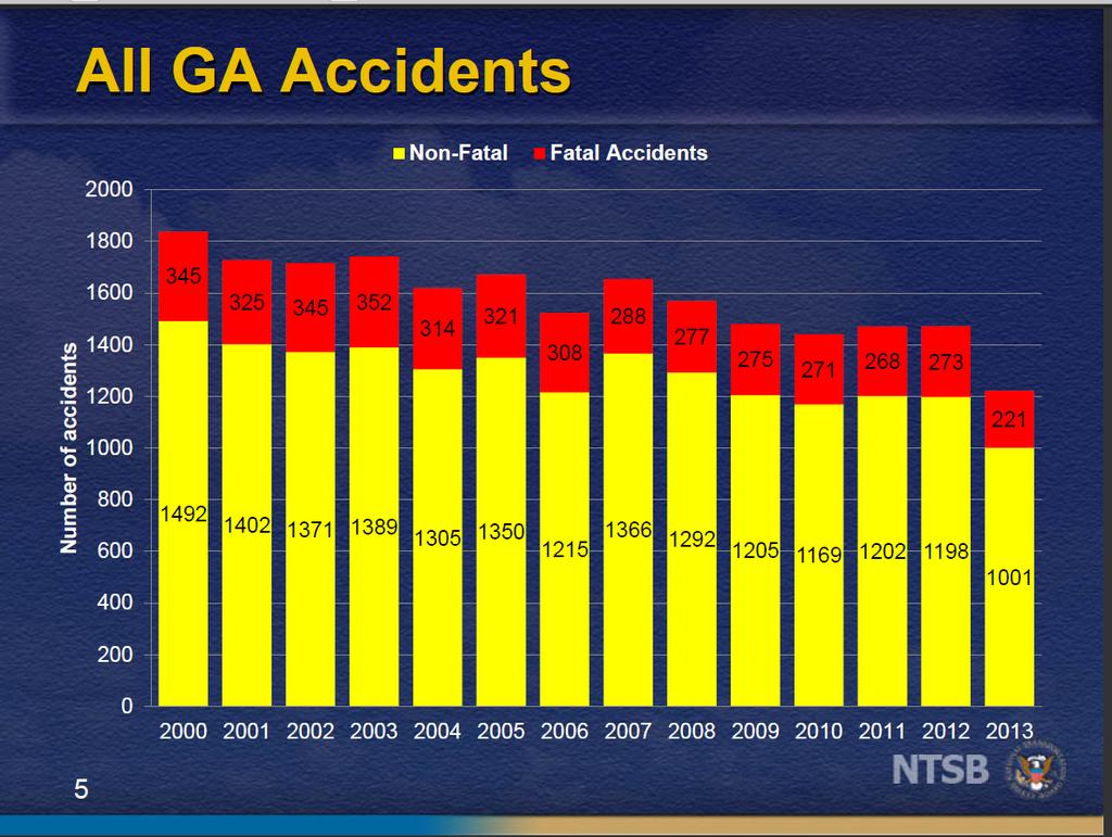
3 About Today n Goal Help You Understand Aviation Weather Better n How Active Participation n Why Stay Safe & Alive n Weather Accounts for 15% of all GA accidents n 25% of all Weather Accidents are fatal (NASA study)
4
5
6

7 Agenda n Decoding Aviation Weather Information Sources of Aviation Weather Weather Information and what it means n Weather Trivia Question & Break n Aviation Weather Resources n Weather Trivia Question & Break n Flight Scenario

8 Ground Rules n Get the Information You Want (Ask Questions) n 2 Breaks come and go as needed n Cell Phones Off Please n Chance to win Prizes Test Your Weather Trivia knowledge n Have Fun While Learning
9 World Area Forecast Centers n U.S. NWS Washington DC n U.K. Met Office Exeter, U.K. n Responsibility for providing worldwide weather information to aviation industry users, under agreement with ICAO. n Acquire and disseminate global observations & forecasts, and provide global numerical model output.
10 U.S. Weather n NOAA National Oceanic and Atmospheric Administration NWS 122 Weather Forecast Offices n Issues TAF s for airports in forecast area n Issues Weather Watches and Warnings n Operates NEXRAD radars in forecast area SPC Storm Prediction Center (Norman) n Issues Severe Thunderstorm/Tornado Watches n Issues Convective Outlooks & Mesoscale Discussions TPC Tropical Prediction Center (Miami) n Issues Tropical Storm/Hurricane bulletins for the Atlantic, Caribbean, Gulf of Mexico and Eastern Pacific n Also centers in Honolulu (Central Pacific Hurricane Center) and Guam (Joint Typhoon Warning Center)
 n Operates and disseminates GOES (geostationary) and POES")
11 U.S. Weather n NOAA AWC Aviation Weather Center (Kansas City) n Issues SIGMETs and AIRMETs n Issues Convective SIGMETs n Issues Area Forecasts Volcanic Ash Advisory Center (Washington) n Issues Volcanic Ash Advisories n 8 other centers around the globe NESDIS National Environmental Satellite Data and Information Service (Washington) n Operates and disseminates GOES (geostationary) and POES (polar orbiting) satellite imagery
12 n NOAA U.S. Weather Center Weather Service Units n NWS Meteorologist located within an ARTCC n Issues Center Weather Advisories (CWA) within the FIR n Issues Meteorological Impact Statements (MIS) within the FIR National Center for Environmental Prediction (NCEP) n Ingests regional and worldwide climate data Surface obs, upper air obs, radiosonde balloons, satellites, aircraft, NEXRAD, ships, buoys etc n Runs worldwide and regional numerical weather prediction and climate models


13 Decoding Text Reports n METAR Observations ASOS: Automated Surface Observing System n Manual Augmentation n Completely Automated n Visibility n Clouds n Weather n Winds n Precipitation n SLP/Altimeter n Temp/Dew Point n Remarks
14 Decoding Text Reports n METAR Observations coded vs decoded METAR KAPA Z 29003KT 8SM FEW100 SCT140 BKN220 19/13 A3032 RMK AO2 SLP205 T = METAR: hourly observation for KAPA issued Wind: 290 at 3 knots Visibility: 8 miles Sky: 10000ft few, 14000ft scattered, 22000ft broken Temperature: 19 C (66 F) Dew point: 13 C (55 F) Altimeter: Remarks: automated station with precipitation discriminator, sea level pressure hpa, T =
15 Decoding Text Reports n METAR Observations KXYZ Z AUTO 17012G25 110V200 1/2SM R30L/3500V5000FT TSSN VV002 SCT008 BKN012 OVC020CB M02/M04 A2992 RMK A02 PKWND 17028/0123 TSB05 PRESFR SLP132 OCNL LTGICCG ALQDS MOV NE SNINCR 1/2 4/002 P T = Station ID: KXYZ Day & Time: Z 01 = First day of current month 1153Z = 1153 UTC Report Type: AUTO = indicates completely automated observation COR = Corrected Observation Blank = Observer input is possible Wind: 17012G = wind direction of 170 deg (reference from true north) 12 = 12 kt sustained wind speed (2 minute average) G25 = gusting to 25 kts (highest gust last 10 minutes, must exceed 10 kts between lulls and peaks to be reported as a gust) 110V200 = wind direction variable between 110 and 220 deg (must exceed 60 deg to be reported as variable and speed exceed 6 kts)
16 Decoding Text Reports n METAR Observations KXYZ Z AUTO 17012G25 110V200 1/2SM R30L/3500V5000FT TSSN VV002 SCT008 BKN012 OVC020CB M02/M04 A2992 RMK A02 PKWND 17028/0123 TSB05 PRESFR SLP132 OCNL LTGICCG ALQDS MOV NE SNINCR 1/2 4/002 P T = Visibility: 1/2SM Prevailing visibility reported in statute miles from sensor. Tower or Surface visibility can be reported in remarks section if different from prevailing visibility. Lowest report is M1/4SM. If Visibility is 1 SM or less, RVR is reported if available. If visibility is greater than 10SM, it is reported as 10SM.
17 Decoding Text Reports n METAR Observations KXYZ Z AUTO 17012G25 110V200 1/2SM R30L/3500V5000FT TSSN VV002 SCT008 BKN012 OVC020CB M02/M04 A2992 RMK A02 PKWND 17028/0123 TSB05 PRESFR SLP132 OCNL LTGICCG ALQDS MOV NE SNINCR 1/2 4/002 P T = RVR: R30L/3500V5000FT Runway 30L Visual Range 3500 ft variable to 5000 ft. Weather: TSSN Thunderstorm with moderate snow. Intensity Descriptor Precipitation Obscuration Other - Light MI Shallow DZ Drizzle BR Mist PO Dust/Sand Devils Moderate PR Partial RA Rain FG Fog SQ Squalls + Heavy BC Patches SN Snow FU Smoke FC Funnel Cloud VC Vicinity DR Drifting SG Snow Grains DU Dust +FC Tornado / Waterspout BL Blowing IC Ice Crystals SA Sand SS Sand Storm SH Showers PL Ice Pellets HZ Haze DS Dust Storm TS Thunderstorm PY Spray FZ Freezing GR Hail GS Snow Pellets UP Unknown Precipitation
18 Decoding Text Reports n METAR Observations KXYZ Z AUTO 17012G25 110V200 1/2SM R30L/3500V5000FT TSSN VV002 SCT008 BKN012 OVC020CB M02/M04 A2992 RMK A02 PKWND 17028/0123 TSB05 PRESFR SLP132 OCNL LTGICCG ALQDS MOV NE SNINCR 1/2 4/002 P T = Cloud Layers: VV002 = Indefinite Ceiling, Vertical Visibility = 200 ft (AGL) SCT008 = Scattered clouds at 800 ft (AGL). SCT = 1/8 to 3/8 coverage BKN012 = Broken clouds at 1200 ft (AGL). BKN = 4/8 to 7/8 coverage OVC020CB = Overcast clouds including Cumulonimbus at 2000 ft (AGL) Designator Coverage Remarks CLR 0/8 No clouds below 12,000 ft. From Automated Observation SKC 0/8 No clouds observed by manual observer FEW 1/8 2/8 No Ceiling SCT 3/8 4/8 No Ceiling BKN 5/8 7/8 Ceiling OVC 8/8 Ceiling VV Obscured Indefinite Ceiling, Vertical Visibility CB TCU Cumulonimbus Clouds Towering Cumulus Note: No clouds from ASOS/AWOS systems are reported above FL120. Clouds above FL120 can be added by human observer.
19 Decoding Text Reports n METAR Observations KXYZ Z AUTO 17012G25 110V200 1/2SM R30L/3500V5000FT TSSN VV002 SCT008 BKN012 OVC020CB M02/M04 A2992 RMK A02 PKWND 17028/0123 TSB05 PRESFR SLP132 OCNL LTGICCG ALQDS MOV NE SNINCR 1/2 4/002 P T = Temperature/Dew Point: M02/M04 Temperature = -2 deg C (M indicates temp below zero) Dew Point = -4 deg C MM indicates a missing temperature or dew point Altimeter: A2992 Altimeter setting of inches of mercury. Indicates Station altitude when altimeter is set to this setting and aircraft at station Remarks: A02 Indicates automated observation with the ability to detect precipitation types. A01 Indicates automated observation with no ability to detect precipitation types, so present weather is not included in METAR.
20 Decoding Text Reports n METAR Observations KXYZ Z AUTO 17012G25 110V200 1/2SM R30L/3500V5000FT TSSN VV002 SCT008 BKN012 OVC020CB M02/M04 A2992 RMK A02 PKWND 17028/0123 TSB05 PRESFR SLP132 OCNL LTGICCG ALQDS MOV NE SNINCR 1/2 4/002 P T = Remarks: PKWND 17028/0123 Peak wind gust of 170 deg at 28 kts, observed at 0123Z TSB05 Thunderstorm began at 05 minutes past the hour PRESFR Pressure falling rapidly SLP132 Sea Level Pressure of mb. Basic interpretation rule: If 3 digit number is < 500, put a 10 in front to get SLP, 132 = mb If 3 digit number is >500, put a 9 in front to get SLP, 996 = mb Or, put a 9 or 10 in front and see which one brings SLP closer to OCNL LTGICCG ALQDS MOV NE Occasional Lightning In Cloud and Cloud to Ground All Quadrants Moving Northeast. OCNL (Occasional) = less than 1 flash per minute FRQ (Frequent) = 1-6 flashes per minute CONS (Continuous) = more than 6 flashes per minute CC = Cloud to Cloud IC = In Cloud CG = Cloud to Ground CA = Cloud to Air
21 Decoding Text Reports n METAR Observations KXYZ Z AUTO 17012G25 110V200 1/2SM R30L/3500V5000FT TSSN VV002 SCT008 BKN012 OVC020CB M02/M04 A2992 RMK A02 PKWND 17028/0123 TSB05 PRESFR SLP132 OCNL LTGICCG ALQDS MOV NE SNINCR 1/2 4/002 P T = Remarks: SNINCR 1/2 Snow Increase on ground, 1 inch increase in last hour, 2 inches total depth 4/002 Snow Depth = 2 inches total on ground (If not snowing, provided with augmented observation in morning, provided as snow increases during snowfall P0010 Precipitation in past hour = 0.10 inches (liquid equivalent) Precipitation in past 3 or 6 hours = 0.25 inches (liquid equivalent) 3 hour totals at 0300, 0900, 1500, and 2100 UTC observations 6 hour totals at 0000, 0600, 1200 and 1800 UTC observations Precipitation in past 24 hours = 0.32 inches (liquid equivalent) Provided at 1200 UTC observation
22 Decoding Text Reports n METAR Observations KXYZ Z AUTO 17012G25 110V200 1/2SM R30L/3500V5000FT TSSN VV002 SCT008 BKN012 OVC020CB M02/M04 A2992 RMK A02 PKWND 17028/0123 TSB05 PRESFR SLP132 OCNL LTGICCG ALQDS MOV NE SNINCR 1/2 4/002 P T = Remarks: T Temp and Dew Point with additional accuracy. T indicates Temp group next 4 digits provide actual measured temp and dew point. First digit indicated positive (0) or negative (1) value, next 3 digits are value with tenths Temp = -1.8 deg C, Dew Point = -4.2 deg C Max Temp (1) past 3 or 6 hours. 3 hour max for observations at 0300, 0900, 1500 and 2100 UTC. 6 hour max for obs at 0000, 0600, 1200 and 1800 UTC Max temp past 6 hours = -1.0 deg C Min Temp (2) past 3 or 6 hours. 3 hour min for observations at 0300, 0900, 1500 and 2100 UTC. 6 hour min for obs at 0000, 0600, 1200 and 1800 UTC Min temp past 6 hours = -5.1 deg C Max/Min Temp group (4) past 24 hours. Provided at local midnight obs. Max Temp past 24 hours = 1.5 deg C Min Temp past 24 hours = -7.5 deg C
23 n Decoding Text Reports METAR Observations KXYZ Z AUTO 17012G25 110V200 1/2SM R30L/3500V5000FT TSSN VV002 SCT008 BKN012 OVC020CB M02/M04 A2992 RMK A02 PKWND 17028/0123 TSB05 PRESFR SLP132 OCNL LTGICCG ALQDS MOV NE SNINCR 1/2 4/002 P T = Remarks: Pressure Tendency Group. Next digit indicates pressure tendency for past 3 hours: Number Meaning 0 Pressure increasing then decreasing, but higher than 3 hours ago 1 Pressure increasing then steady 2 Pressure increasing steadily 3 Pressure Steady then increasing 4 Pressure Steady 5 Pressure decreasing then increasing 6 Pressure decreasing then steady 7 Pressure decreasing steadily 8 Pressure steady then decreasing 029 Pressure change in mb = 2.9 mb change in past 3 hours = End of Report $ Indicates maintenance is required on system
24 n Decoding Text Reports METAR Observations KXYZ Z AUTO 17012G25 110V200 1/2SM R30L/3500V5000FT TSSN VV002 SCT008 BKN012 OVC020CB M02/M04 A2992 RMK A02 PKWND 17028/0123 TSB05 PRESFR SLP132 OCNL LTGICCG ALQDS MOV NE SNINCR 1/2 4/002 P T = Remarks: Meaning: RVRNO Runway Visual Range not available PWINO Present Weather not available PNO Precipitation amount not available FRZRANO Freezing rain detection not available TSNO Thunderstorm detection not available SLPNO Sea Level Pressure not available SFC VIS Surface Visibility as measured from ground observer TWR VIS Tower Visibility as measured from tower observer FIRST First observation with manual observer present LAST Last observation with manual observer present NOSPECI Indicates no SPECI intermediate observations are available ACFT MSHP Indicates an aircraft accident has occurred at the airport ACSL SW-NW Altocumulus Standing Lenticular Southwest through Northwest ROTOR CLD W Rotor Cloud West
25 Decoding Text Reports n Terminal Aerodrome Forecast - TAF Prepared by NWS Forecast Offices (WFO) n 24 or 30 Hour Forecast, Issued at 0000, 0600, 1200 and 1800 UTC, amendments (AMD) issued as needed n Prevailing and temporary conditions of the following phenomenon by time period for a 5 sm radius from airport: Winds n n Visibility n Weather n Clouds n n n Speed in knots in most TAFs, mps in Russia/China and kph in some former British colonies Low Level Wind Shear Statute miles in North America, Meters elsewhere Same codes as used in METAR observations Clouds bases given in hundreds of feet AGL Cloud Types (CB, TCU when present) Vertical Obscuration (VV)
26 Decoding Text Reports n Terminal Aerodrome Forecast - TAF KABC Z 2512/ G25KT P6SM VCTS SCT060 BKN120 FM VRB15G30KT 3SM TSRA BKN010CB OVC060 TEMPO 2518/2520 1/2SM +TSRA OVC005 FM G25KT P6SM FEW030 SCT120 WS020/24050KT FM VRB03KT P6SM SKC PROB /4SM FG VV002 FM KT P6SM SKC Station ID: KABC Issuance Time: Z 25 = 25th day of current month 1140Z = 1140 UTC Forecast Period: 2512/ = 25 th day of month at 1200 UTC 2612 = 26 th day of month at 1200 UTC Forecast period extends from 1200 UTC on the 25 th through 1200 UTC on the 26th Prevailing Conds: 50% or greater probability of occurrence for greater than ½ of the sub-divided forecast time period. Includes initial forecast and all FM groups. Winds: 16012G25KT Wind from 160 deg true north at 12 kts gusting to 25 kts Visibility: P6SM Visibility Unrestricted of 6 or more statute miles Weather: VCTS Thunderstorms in the vicinity (area from 5-10 sm from airport)
27 Decoding Text Reports n Terminal Aerodrome Forecast - TAF KABC Z 2512/ G25KT P6SM VCTS SCT060 BKN120 FM VRB15G30KT 3SM TSRA BKN010CB OVC060 TEMPO 2518/2520 1/2SM +TSRA OVC005 FM G25KT P6SM FEW030 SCT120 WS020/24050KT FM VRB03KT P6SM SKC PROB /4SM FG VV002 FM KT P6SM SKC Clouds: SCT060 BKN120 Scattered (3/8-4/8 coverage) clouds at 6000 ft (AGL) Broken (5/8-7/8 coverage) clouds at 12,000 ft (AGL) Prevailing Conds: FM From 1600 UTC on the 25th Winds: VRB15G30KT Variable wind direction with wind speed 15 kts gusting to 30 kts Visibility: 3SM Visibility of 3 statute miles Weather: TSRA Thunderstorms with rain Clouds: BKN010CB OVC060 Broken (5/8-7/8 coverage) clouds at 1000 ft (AGL) with CB clouds Overcast (8/8 coverage) clouds at 6000 ft (AGL)
28 Decoding Text Reports n Terminal Aerodrome Forecast - TAF KABC Z 2512/ G25KT P6SM VCTS SCT060 BKN120 FM VRB15G30KT 3SM TSRA BKN010CB OVC060 TEMPO 2518/2520 1/2SM +TSRA OVC005 FM G25KT P6SM FEW030 SCT120 WS020/24050KT FM VRB03KT P6SM SKC PROB /4SM FG VV002 FM KT P6SM SKC Temporary Change to Prevailing Conditions: TEMPO Used to indicate temporary fluctuations in meteorological conditions that have a 50% or greater probability of occurrence, will last less than 1 hour for each occurrence, and in aggregate cover less than half of the TEMPO time period. TEMPO 2518/2520 Temporary conditions from 1800 to 2000 UTC on the 25th Winds: If no winds provided in TEMPO, same winds as in prevailing conditions Visibility: 1/2SM Visibility of ½ statue mile Weather: +TSRA Thunderstorms with heavy rain Clouds: OVC005 Overcast (8/8 coverage) clouds at 500 ft (AGL)
29 Decoding Text Reports n Terminal Aerodrome Forecast - TAF KABC Z 2512/ G25KT P6SM VCTS SCT060 BKN120 FM VRB15G30KT 3SM TSRA BKN010CB OVC060 TEMPO 2518/2520 1/2SM +TSRA OVC005 FM G25KT P6SM FEW030 SCT120 WS020/24050KT FM VRB03KT P6SM SKC PROB /4SM FG VV002 FM KT P6SM SKC Prevailing Conds: FM New set of prevailing conditions starting at 2200 UTC on the 25th Winds: 31010G25KT Winds from 310 deg (true north) at 10 kts gusting to 25 kts Visibility: P6SM Unrestricted visibility of 6 statute miles or more Weather: No significant weather if none included Clouds: FEW030 SCT120 Few (1/8-2/8 coverage) clouds at 3000 ft (AGL) Scattered (3/8-4/8 coverage) clouds at 12,000 ft (AGL) Wind Shear: WS020/24050KT Low Level Wind Shear at 2000 ft AGL, wind from 240 deg at 50 kts at specified altitude. Only used for non-convective wind shear. Forecasted when the following criteria is met: When one or more PIREP is received that reported non-convective LLWS within 2000 ft AGL in the vicinity of the airport, causing an indicated air speed loss or gain of 20 kts or more, AND/OR, VWS of 10kts or more per 100 ft in a layer more than 200 ft thick is reported or is reliably expected within 2000 ft AGL.
30 Decoding Text Reports n Terminal Aerodrome Forecast - TAF KABC Z 2512/ G25KT P6SM VCTS SCT060 BKN120 FM VRB15G30KT 3SM TSRA BKN010CB OVC060 TEMPO 2518/2520 1/2SM +TSRA OVC005 FM G25KT P6SM FEW030 SCT120 WS020/24050KT FM VRB03KT P6SM SKC PROB /4SM FG VV002 FM KT P6SM SKC Prevailing Conds: FM New set of prevailing conditions starting at 0400 UTC on the 26th Winds: VRB03KT Variable wind direction at 3 kts or less Visibility: P6SM Unrestricted visibility of 6 statute miles or more Weather: No significant weather if none included Clouds: SKC Sky Clear, no clouds present. CLR is not used in TAF, only METAR CAVOK is used in international TAF and implies unrestricted visibility as well as no clouds
31 Decoding Text Reports n Terminal Aerodrome Forecast - TAF KABC Z 2512/ G25KT P6SM VCTS SCT060 BKN120 FM VRB15G30KT 3SM TSRA BKN010CB OVC060 TEMPO 2518/2520 1/2SM +TSRA OVC005 FM G25KT P6SM FEW030 SCT120 WS020/24050KT FM VRB03KT P6SM SKC PROB /4SM FG VV002 FM KT P6SM SKC Change to Prevailing Conds: PROB40 The Probability group is used by NWS forecasters to forecast a probability (between 30% and 50% chance) of a weather phenomenon occurring. PROB40 cannot be used in the first 6 hours of a TAF. Note that PROB30 is no longer used. Change: PROB %-50% chance of new conditions between 0600 and 1000 UTC Winds: No change to prevailing wind conditions Visibility: 1/4SM Visibility ¼ statute mile Weather: FG Fog (used only when visibility is less than 5/5 sm, BR used otherwise) Clouds: VV002 Indefinite ceiling, vertical visibility of 200 ft AGL
32 Decoding Text Reports n Terminal Aerodrome Forecast - TAF KABC Z 2512/ G25KT P6SM VCTS SCT060 BKN120 FM VRB15G30KT 3SM TSRA BKN010CB OVC060 TEMPO 2518/2520 1/2SM +TSRA OVC005 FM G25KT P6SM FEW030 SCT120 WS020/24050KT FM VRB03KT P6SM SKC PROB /4SM FG VV002 FM KT P6SM SKC Prevailing Conds: FM Prevailing conditions from 1000 UTC on the 26th Winds: 00000KT Calm winds Visibility: P6SM Unrestricted Visibility of 6 statute miles or more Weather: No significant weather Clouds: SKC Sky clear, no clouds present
33 Decoding Text Reports n Terminal Aerodrome Forecast - TAF Other Terms used in TAFs: NSW: No Significant Weather Only used in TEMPO group to indicate no significant weather VA: Volcanic Ash Always included when volcanic ash is present Visibility: 9999 International TAF use for unrestricted visibility, means 10 KM or greater NIL: visibility. 40KM Some countries forecast visibilities greater than 10 KM, such as New Zealand TAF suspended Until complete data is received to issue next scheduled TAF A forecaster usually requires 2 consecutive hourly METAR observations before a TAF is issued for a terminal. No significant weather TX23/22Z: Maximum Temp Forecast (selected intl airports) Max temp of 23 deg C expected at 2200 UTC TN11/13Z: Minimum Temp Forecast (selected intl airports) Minimum temp of 11 deg C expected at 1300 UTC


34 n Decoding Text Reports Pilot Reports PIREP Actual observations from pilots n Aircraft location n Time n Altitude n Aircraft Type n Conditions Temperature Turbulence Icing Wind Velocity & Shear Clouds Thunderstorms Volcanic Ash n Source
35 n Decoding Text Reports Pilot Reports PIREP DCA UA /OV DCA /TM 2042 /FL030 /TP E170 /IC LGT RIME= IAD UA /OV AML /TM 2004 /FL012 /TP SR22 /IC MOD RIME= IAD UA /OV AML /TM 1944 /FL032 /TP FA90 /SK OVC032 /RM DURD= DEN UA /OV KDEN322010/TM 1943/FL380/TP B737/TA M60/WV KT/TB LGT CHOP/RM AWC-WEB:SWA= SFO UA /OV 3930N 13450W/TM 2118/FL310/TP B744/TB LGT-MOD CHOP/RM ZOA CWSU = SEA UA /OV SEA146030/TM 2043/FL145/TP B738/SK TOPS 210/TB CONT LGT MOD/RM DURGC ZSE = SEA UA /OV SEA160040/TM 2029/FL170/TP DH8/TB CONT LGT CHOP/RM DURGD ZSE = CVG UA /OV CVG /TM 2020 /FL090 /TP E145 /TA M03 /IC NEG /RM IMC AT 090= CVG UA /OV CVG /TM 1744 /FLUNKN /TP CRJ7 /SK OVC007 / RM DURC NO TOPS THRU 130/ M01 070/ /070=
 n Strong Surface Winds (> 30 kts) n Non-Convective LLWS below 2000 ft Issued at 0300, 0900, 1500 and 2100 UTC Valid for next 6")
36 n AIRMET Decoding Text Reports Issued by AWC for the following conditions: n Moderate Icing (Zulu) n Moderate Turbulence (Tango) n IFR & Mountain Obscurations (Sierra) n Strong Surface Winds (> 30 kts) n Non-Convective LLWS below 2000 ft Issued at 0300, 0900, 1500 and 2100 UTC Valid for next 6 hours
37 n Decoding Text Reports AIRMET Examples WAUS45 KKCI AAA WA5T SLCT WA AMD AIRMET TANGO UPDT 3 FOR TURB VALID UNTIL SEE SIGMET VICTOR.... AIRMET TURB...WY UT CO...UPDT FROM BPI TO 50E OCS TO CHE TO 30NE DTA TO SLC TO BPI MOD TURB BLW 140. CONDS ENDG 21Z. WAUS45 KKCI WA5Z SLCZ WA AIRMET ZULU UPDT 2 FOR ICE AND FRZLVL VALID UNTIL AIRMET ICE...WY UT CO AZ NM FROM BFF TO GLD TO 50W LBL TO ABQ TO 30N PHX TO 60S EED TO EED TO SLC TO BFF MOD ICE BLW 160. CONDS CONTG BYD 21Z THRU 03Z. WAUS45 KKCI WA5S SLCS WA AIRMET SIERRA UPDT 2 FOR IFR AND MTN OBSCN VALID UNTIL AIRMET IFR...WY UT CO AZ NM FROM 60SW DDY TO BFF TO GLD TO 50W LBL TO CIM TO DRK TO 40E ILC TO 60ESE MLD TO 60SW DDY CIG BLW 010/VIS BLW 3SM PCPN/BR. CONDS ENDG 21Z WY/UT..CONTG RMNDR BYD 21Z THRU 03Z.

38 The G-AIRMET

39 Decoding Text Reports n G-AIRMET Graphical representation for text AIRMETs Issued at 0300, 0900, 1500 and 2100 UTC Display supplemental 00,03,06,09 and 12 hour snapshot graphics of aviation hazards in the 0-6 hour AIRMET valid period as well as the 6-12 hour outlook period. Provided in BUFR format for use in tools, and available as web graphics. Intended to provide a more refined depiction of aviation hazards described in the AIRMET text at more frequent time intervals. Eventually the G-AIRMET will be generated and text will be derived from the graphics.
40 Decoding Text Reports n Area Forecast (FA) Issued by AWC every 8 hours for a 12 hour forecast period plus a 6 hour outlook period Forecast conditions of MVFR and VFR areas and n Thunderstorms and precipitation n Clouds (bases, tops, amount) n Visibilities between 3 and 6 statute miles n Sustained surface winds of 20 kts or more
41 n Decoding Text Reports Area Forecast Example FAUS45 KKCI FA5W SLCC FA SYNOPSIS AND VFR CLDS/WX SYNOPSIS VALID UNTIL CLDS/WX VALID UNTIL OTLK VALID ID MT WY NV UT CO AZ NM. SEE AIRMET SIERRA FOR IFR CONDS AND MTN OBSCN. TS IMPLY SEV OR GTR TURB SEV ICE LLWS AND IFR CONDS. NON MSL HGTS DENOTED BY AGL OR CIG.. SYNOPSIS...UPR LVL LOW 12Z SWRN AZ FCST MOV EWD INTO XTRM SWRN NM BY 06Z. NRN PAC TROF WL MOV INTO XTRM NRN ID-ERN WA BY 06Z. AT SFC..HI PRES RIDGE CONTG OVR CNTRL ROCKIES THRU 06Z. CDFNT 12Z SERN NM WL CONT SWD INTO SWRN TX BY 18Z. CDFNT 12Z ERN AZ WL MOV SEWD INTO MEXICO BY 00Z.. ID NRN...SCT SCT Z SCT080 BKN150. TOPS FL200. OTLK...VFR BECMG MVFR CIG PCPN/BR 04Z. CNTRL MTNS...SCT CI. 19Z SCT150. OTLK...VFR. SWRN...SCT CI. OTLK...VFR. SERN...SCT-BKN065. TOPS Z SCT070. OTLK...VFR. CO MTNS AND WEST... SCT080 OVC TOPS FL180. SCT -SHSN MNLY MTNS. 19Z SCT100 SCT140. OTLK...VFR. FOOTHILLS/PLAINS... ERN PTN PLAINS..SCT- BKN TOPS 150. OTLK...VFR. FOOTHILLS/WRN PTN PLAINS...BKN070. TOPS FL180. TIL 15Z OCNL VIS 3-5SM BR. BECMG 1618 SCT090 SCT150. OTLK...VFR.
42 n Decoding Text Reports SIGMET Issued by AWC for the following conditions: n Severe Icing n Severe Turbulence n Thunderstorms Convective SIGMETs issued separately for CONUS n Widespread Duststorm or Sandstorm n Volcanic Ash n Tropical Cyclones Phenomenon must affect an area of at least 3000 square miles Issued for CONUS, AK, HI, Gulf of Mexico, Caribbean, North Pacific and North Atlantic


43 Decoding Text Reports n SIGMET Issued for a 4 hour period as needed for Icing and Turbulence, 6 hour period for Volcanic Ash and Tropical Cyclones with 12 hour outlook Referenced as: n n n n AWC for CONUS - NOVEMBER through YANKEE, excluding SIERRA and TANGO AWC for Oakland Oceanic FIR - ALFA through HOTEL Honolulu MWO for Oakland Oceanic FIR - NOVEMBER through ZULU AAWU for Anchorage FIR - INDIA through MIKE

44 n Decoding Text Reports SIGMET Examples WSUS05 KKCI WS5V SLCV WS SIGMET VICTOR 1 VALID UNTIL ID UT NV CA AND CSTL WTRS FROM BOI TO PIH TO ILC TO 60SW RZS TO PYE TO FMG TO BOI OCNL SEV TURB BTN FL240 AND FL360 DUE TO WNDSHR ASSOCD WITH JTST AND UPR TROF. RPRTD BY ACFT E OF CZQ BTN FL310 AND FL340. CONDS MOVG SLOLY SWD AND CONTG BYD 1755Z.

45 Decoding Text Reports n Convective SIGMET Issued every hour for a 2 hour period for: n Severe Thunderstorms (hail >1 in, winds > 50 kts) n Line of Thunderstorms 50 mi long, affecting at least 40% of its length n Area of active thunderstorms at least 3000 sq mi affecting at least 40% of the area Outlook issued for 4 hour period

46 n Decoding Text Reports Convective SIGMET Example: CONVECTIVE SIGMET 54C VALID UNTIL 1855Z WI IL FROM 30E MSN-40ESE DBQ DMSHG LINE TS 15 NM WIDE MOV FROM 30025KT. TOPS TO FL450. WIND GUSTS TO 50 KT POSS.
 Issue")

47 Decoding Text Reports n Volcanic Ash Advisories 9 Volcanic Ash Advisory Centers (VAAC) Issue advisories when volcanic eruption has occurred or is imminent Issued for 6 hour period, updated every 6 hours
48 n Decoding Text Reports Volcanic Ash Advisory Example: VOLCANIC ASH ADVISORY ISSUED: 2003JUL10/1300Z VAAC: WASHINGTON VOLCANO: ANATAHAN LOCATION: N1621E14540 AREA: MARIANA ISLANDS SUMMIT ELEVATION: 2585 FT (788 M) ADVISORY NUMBER: 2003/251 INFORMATION SOURCE: GOES 9 IMAGERY. GFS MODEL WINDS FORECAST ERUPTION DETAILS: ASH AND GAS EMISSIONS SINCE MAY 10. OBS ASH DATE/TIME: 09/1202Z. OBS ASH CLOUD: ASH NOT IDENTIFIABLE FROM SATELLITE DATA. WINDS SFC/FL080 MOVING SW KNOTS. FCST ASH CLOUD +6H: SEE SIGMETS. REMARKS: THE ASH PLUME OBSERVED IN VISIBLE IMAGERY IS TOO THIN AND DIFFUSE TO BE SEEN IN INFRARED AND MULTISPECTRAL IMAGAERY. ANY ASH UP TO FL080 SHOULD MOVE TOWARDS THE SW AT KNOTS. NEXT ADVISORY: WILL BE ISSUED BY 2003JUL10/1900Z.


49 Decoding Text Reports n Center Weather Advisories Issued by the Center Weather Service Units for conditions impacting flight in the enroute and terminal environments in the FIR Valid for 2 hours, updated every 2 hours or as needed

50 n Decoding Text Reports Center Weather Advisory Example: n n CWA - Center Weather Advisory ZID CWA 103 VALID UNTIL FROM 45NE APE-80W BKW-70WNW IIU-30NE ROD-45NE APE SCT TS. MOVE FROM 30020KT. MAX TOPS ABV FL450. ACTIVITY IS INCREASING. =

51 n Decoding Text Reports Meteorological Impact Statement Example: n n MIS - Meteorological Impact Statement ZID MIS 03 VALID FOR ATC PLANNING PURPOSES ONLY... IN ZID E OF A LN FM 30S LOZ-30SE IND-65E HNN...SCT TS DVLPG THRU 21Z...FRMG SML CLUSTERS/BKN LNS. MAX TOPS ABV FL450. MOST TOPS FL MOV FM 30025KT. N OF A LN FM 45SW TTH-15E BKW SCT MOD CHOP ISOL MOD TURB IN TS OUTFLOW DMSH THRU 21Z.=
52 Decoding Text Reports n Tropical Cyclone Bulletins Issued by the National Hurricane Center in Miami Created every 6 hours at 0300, 0900, 1500 and 2100 UTC for the Atlantic, Caribbean, Gulf of Mexico and Eastern Pacific TROPICAL STORM LOWELL FORECAST/ADVISORY NUMBER 12 NWS NATIONAL HURRICANE CENTER MIAMI FL EP UTC WED AUG THERE ARE NO COASTAL WATCHES OR WARNINGS IN EFFECT. TROPICAL STORM CENTER LOCATED NEAR 19.4N 121.5W AT 20/2100Z POSITION ACCURATE WITHIN 30 NM PRESENT MOVEMENT TOWARD THE NORTHWEST OR 315 DEGREES AT 4 KT ESTIMATED MINIMUM CENTRAL PRESSURE 988 MB MAX SUSTAINED WINDS 55 KT WITH GUSTS TO 65 KT. 50 KT... 50NE 50SE 0SW 0NW. 34 KT...120NE 180SE 150SW 110NW. 12 FT SEAS..270NE 360SE 240SW 240NW. WINDS AND SEAS VARY GREATLY IN EACH QUADRANT. RADII IN NAUTICAL MILES ARE THE LARGEST RADII EXPECTED ANYWHERE IN THAT QUADRANT. REPEAT...CENTER LOCATED NEAR 19.4N 121.5W AT 20/2100Z AT 20/1800Z CENTER WAS LOCATED NEAR 19.3N 121.4W FORECAST VALID 21/0600Z 19.8N 121.9W MAX WIND 60 KT...GUSTS 75 KT. 50 KT... 50NE 50SE 0SW 0NW. 34 KT...150NE 180SE 150SW 110NW. FORECAST VALID 21/1800Z 20.6N 122.6W MAX WIND 60 KT...GUSTS 75 KT. 50 KT... 50NE 50SE 0SW 0NW. 34 KT...150NE 180SE 120SW 120NW. FORECAST VALID 22/0600Z 21.6N 123.6W MAX WIND 55 KT...GUSTS 65 KT. 50 KT... 50NE 50SE 0SW 0NW. 34 KT...150NE 150SE 120SW 120NW. FORECAST VALID 22/1800Z 22.8N 124.9W MAX WIND 50 KT...GUSTS 60 KT. 50 KT... 50NE 50SE 0SW 0NW. 34 KT...150NE 150SE 120SW 120NW. FORECAST VALID 23/1800Z 24.9N 127.8W MAX WIND 35 KT...GUSTS 45 KT. 34 KT...120NE 90SE 60SW 90NW.

53 n Decoding Text Reports Tropical Cyclone Bulletins

54 Decoding Text Reports n Wind & Temp Aloft Forecast (FD) Created using NWS GRIB numerical forecast data Provides forecast of wind velocity and temperature by altitude for a specific future time Updated every 6 hours from new forecast data
55 n Decoding Text Reports Wind & Temp Aloft Forecast Examples VALID Z FOR USE Z. TEMPS NEG ABV FT MKC KAPA FD DATA BASED ON Z Z P M M M M M M32 06Z P M M M M M M32 12Z M M M M M M M32 18Z P M M M M M M32 Wind Direction always reference true north, speed in knots If wind speed exceeds 99 kts, 50 is added to wind direction e.g = wind from 270 deg (77-50=27) at 103 kts
 can graphically depict the atmosphere profile and calculate various stability indexes and")
56 Radiosonde Balloons n Weather Balloons are launched twice daily (0000 and 1200 UTC) worldwide As balloon ascends it measures the following: n Pressure, Geopotential Height, Temperature, Dew Point, Wind Velocity n Thermodynamic diagrams (Skew-T/Log-P) can graphically depict the atmosphere profile and calculate various stability indexes and parameters
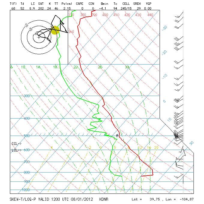
57 Skew-T/Log-P Diagram

58 Break


 Hawaii B.")
59 Weather Trivia Which U.S. state hold the record for the highest 24 hour precipitation amount? A.) Hawaii B.) California C.) Texas D.) Florida
60 Weather Trivia Which U.S. state hold the record for the highest 24 hour precipitation amount? Answer: A.) Hawaii 38 Kilauea Plantation 1956 B.) California Hoegees Camp 1943 C.) Texas 43 inches near Alvin, TX July associated with T.S. Claudette D.) Florida 38.7 Yankeetown 1950 World record is 72 inches of rain in 24 hours on La Reunion Island in the Indian Ocean associated with a tropical cyclone Jan Colorado record is in Holly, June 17, 1965
61 Aviation Weather Resources Jeppesen n Text and Graphic weather and NOTAMs n n
62 Aviation Weather Resources NCAR & Univ of Wyoming n Skew-T Log P diagrams n n

63 Aviation Weather Resources NWS Denver (Boulder) n Point Specific Forecasts n Radar Data n Satellite Imagery n Forecast Discussion n Aviation Weather n Balloon and Soaring Forecast n
64 Aviation Weather Resources Storm Prediction Center n Thunderstorms Forecast n Severe Weather Forecast n Tornado, Hail and Wind Probabilities n
65 Aviation Weather Resources NOAA Enhanced Data Display n Current Surface Data n
66 Aviation Weather Resources Numerical Model Data n n
67 Aviation Weather Resources Forecast Skew T Log P Diagrams n fcstsound.html


68 Aviation Weather Resources Aviation Weather Center n Aviation weather n G-AIRMET n SIGMETs n PIREPs n Turbulence (GTG) n Icing (CIP and FIP) n Flight Path Tool n

69 Break


70 Weather Trivia Question In 2012, what weather phenomena accounted for the highest number of weather related fatalities in the U.S.? A. Heat B. Floods C. Tornadoes D. Lightning
 - 10 yr avg = 76 / 30 yr avg = 89 C. Tornadoes (70) - 10 yr avg = 109 / 30 yr avg = 74 D. Lightning (28) - 10 yr avg = 35 / 30 yr avg = 52 E. Cold (8) - 10 yr avg = 27 F.")
71 Weather Trivia Question In 2012, what weather phenomena accounted for the highest number of weather related fatalities in the U.S.? Answer: A. Heat (155) 10 year average = 117 B. Floods (29) - 10 yr avg = 76 / 30 yr avg = 89 C. Tornadoes (70) - 10 yr avg = 109 / 30 yr avg = 74 D. Lightning (28) - 10 yr avg = 35 / 30 yr avg = 52 E. Cold (8) - 10 yr avg = 27 F. Hurricanes (4) - 10 yr avg = 109 / 30 yr avg = 47
 Personal Minimums")

72 Flight Scenario Planning an IFR flight from KAPA to KFLG Flight to be conducted in a Piper Malibu Mirage Planned departure at 1800 UTC (1100 MDT) Personal Minimums include: n Avoid all thunderstorms n Light to moderate turbulence, no severe n Trace to light icing, no moderate or severe n Landing need ½ sm visibility and 500 ft ceiling

73 Possible Route
74 300 mb (FL300) Analysis Fri 1200Z
75 500 mb (FL180) Analysis Fri 1200Z
76 700 mb (FL100) Analysis Fri 1200Z

77 850 mb (FL050) Analysis Fri 1200Z

78 Surface Analysis Fri 1200Z

79 IR Satellite/Radar Fri 1500Z

80 Visible Satellite + Lightning Fri 1500Z

81 Water Vapor Satellite Image Fri 1600Z

82 Surface Analysis Fri 1500Z

83 Weather Depiction Aug Z

84 IR Satellite/Radar Aug Z

85 Visible Satellite + Lightning Fri 1600Z

86 Turbulence Analysis FL Fri 1500Z

87 Icing Analysis FL Fri 1500Z

88 G-AIRMET Fri 1700Z

89 KDEN Sounding Fri 1200Z

90 KFLG Sounding Aug Z
91 METAR and TAFs Fri 1700Z KAPA Z 2216/ KT P6SM SCT070 BKN120 FM KT P6SM VCTS SCT070CB BKN120 TEMPO 2221/2301 VRB20G35KT 4SM TSRA BKN050CB FM KT P6SM VCSH SCT035 OVC060 TEMPO 2301/2304 VRB15G25KT 4SM TSRA BKN035CB FM KT P6SM SCT050 OVC080 PROB /2308 -SHRA BKN050 FM KT P6SM SCT080 BKN120= KAPA Z 00000KT 10SM FEW075 SCT110 OVC140 19/12 A3021 RMK AO2 SLP167 T = KGUC Z AUTO 03003KT 10SM CLR 14/08 A3034 RMK AO1= KFMN Z 10005KT 10SM CLR 18/12 A3021 RMK AO2 SLP173 T KFLG Z 2218/ KT P6SM FEW020 SCT030 BKN070 TEMPO 2218/2222 -SHRA BKN020 FM VRB03KT P6SM SCT030= KFLG Z 23008KT 10SM SCT010 SCT019 OVC080 15/11 A3029 RMK AO2 SLP176 T =
92 NWS Aviation Discussion Fri 1730Z APA TSTMS WILL INCREASE IN COVERAGE AND INTENSITY BY EARLY TO MID AFTN WITH HIGHEST THREAT FM 21Z-01Z. POTENTIAL EXISTS FOR STRONG STORMS WHICH MAY PRODUCE HEAVY RAIN AND GUSTY WINDS TO 50 MPH. COULD SEE VISIBILITIES DROP DOWN TO 1-3 MILES WITH CEILINGS BLO 3000 FT FOR PERIODS UP TO 30 MINUTES ANY TIME BETWEEN 21Z AND 01Z IF AIRPORTS TAKE A DIRECT HIT FM STORMS. AFTER 01Z CONDITIONS SHOULD IMPROVE AS TSTMS MOVE OFF TO THE NE IN ASSOCIATION WITH THE DISTURBANCE MENTIONED ABV. FLG FOR THE 18Z PACKAGE...SOME CONVECTIVE SHOWER/STORM DEVELOPMENT IS EXPECTED THIS AFTERNOON BUT IS LIKELY TO BE WEAK/SUPPRESSED IN THE WAKE OF THE DEPARTING UPPER LOW. THERE IS A POSSIBILITY OF BRIEF MVFR CONDITIONS IN ONE OF THESE SHOWERS...GREATEST AT KINW. VFR CONDITIONS ARE FORECAST AFTER 02Z. AVIATION DISCUSSION NOT UPDATED FOR AMENDMENTS.
93 Friday Observation Data So we have looked at current data from Friday morning Any areas of concern that may impact the flight? Now let s look at some forecast data

94 Precip Accumulation UTC Fri

95 Precip Accumulation UTC Fri

96 Flight Conditions Forecast Aug Z

97 Turbulence Forecast FL Aug Z

98 Icing Forecast FL Aug Z

99 FL100 Winds/Temps Forecast Aug Z

100 Flight Conditions Fri 1800Z

101 Flight Conditions Sat 0000Z

102 Turbulence FL Fri 1900Z

103 Icing FL Fri 1900Z

104 Convective Outlook Fri 1200Z Sat 1200Z
105 KAPA Forecast Sounding Fri 1800Z

106 KFLG Forecast Sounding Sat 0000Z

107 RH Plan View Fri 1800Z

108 RH Profile View Fri 1800Z

109 Temp Plan View Fri 1800Z

110 Temp Profile View Fri 1800Z

111 Turbulence Plan View Fri 1800Z

112 Turbulence Profile View Fri 1800Z

113 Icing Plan View Fri 1800Z

114 Icing Profile View Fri 1800Z
115 Decision Time n What Hazards are of concern? n What options exists?
116 KAPA Z 00000KT 10SM -RA FEW050 BKN100 OVC140 19/12 A3019 RMK AO2 RAB42 SLP160 P T = KGUC Z AUTO 35003KT 10SM FEW070 SCT075 14/08 A3034 RMK AO1= KFMN Z 10007KT 10SM CLR 19/12 A3019 RMK AO2 SLP T = KFLG Z 19008KT 10SM FEW026 SCT043 OVC080 16/10 A3028 RMK AO2 SLP T =
117 NEXRAD Reflectivity Fri 1800Z
118 Visible Satellite + Lightning Fri 1800Z

119 Route Weather Fri 1800Z

120 Route Weather Fri 1800Z
121 NEXRAD Reflectivity Fri 1900Z

122 Visible Satellite + Lightning Fri 1900Z

123 Route Weather Fri 1900Z
124 Route Weather Fri 1900Z

125 NEXRAD Reflectivity Fri 2000Z

126 Visible Satellite + Lightning Fri 2000Z

127 Enroute Weather Fri 2000Z
128 Enroute Weather Fri 2000Z

129 Enroute Weather Fri 2030Z

130 Enroute Weather Fri 2030Z
Aviation Weather For Pilots. Aviation Weather Decoded
 Aviation Weather For Pilots Aviation Weather Decoded Presented by Mike Cetinich About Your Instructor n B.S. Meteorology San Jose State University n Flight Training n Career at Jeppesen (30+ years) Aviation
KEY TO DECODING THE U.S. METAR OBSERVATION REPORT
 KEY TO DECODING THE U.S. METAR OBSERVATION REPORT Example METAR Report METAR KABC 121755Z AUTO 21016G24KT 180V240 1SM R11/P6000FT -RA BR BKN015 0VC025 06/04 A2990 RMK A02 PK WND 20032/25 WSHFT 1715 VIS
TAF CCCC YYGGggZ YYHHHH dddff(f)gffkt VVVVSM [ww NNNhhh] [Wshhh/dddffKT] [TTTTT xxxx] repeated as needed
![TAF CCCC YYGGggZ YYHHHH dddff(f)gffkt VVVVSM [ww NNNhhh] [Wshhh/dddffKT] [TTTTT xxxx] repeated as needed](/thumbs/80/81003809.jpg "TAF CCCC YYGGggZ YYHHHH dddff(f)gffkt VVVVSM [ww NNNhhh] [Wshhh/dddffKT] [TTTTT xxxx] repeated as needed") Encoding TAFs Terminal Aerodome Forecast (TAF) Terminal forecasts for the world follow an internationally accepted format. The TAFs are issued four times daily for 24 hour periods beginning at 00Z, 06Z,
Encoding TAFs Terminal Aerodome Forecast (TAF) Terminal forecasts for the world follow an internationally accepted format. The TAFs are issued four times daily for 24 hour periods beginning at 00Z, 06Z,
TAF Decoder Courtesy of the Aviation Weather Center
 TAF Decoder Courtesy of the Aviation Weather Center A Terminal Aerodrome Forecast (TAF) is a concise statement of the expected meteorological conditions at an airport during a specified period (usually
Aerodrome Forecast (TAF)
") AVIATION WEATHER PRODUCTS () Bureau of Meteorology Aviation Weather Services A is a coded statement of meteorological conditions expected at an and within a radius of five nautical miles of the reference
AVIATION WEATHER PRODUCTS () Bureau of Meteorology Aviation Weather Services A is a coded statement of meteorological conditions expected at an and within a radius of five nautical miles of the reference
Issue of SIGMET/AIRMET warning
 Issue of SIGMET/AIRMET warning 1 Presentation Objectives After this presentation session you will be able to: Warn for Hazardous weather phenomena using the correct ICAO coding with regards to SIGMET/AIRMET
Preflight Weather Analysis Lesson 4 Part 4 of 4
 Preflight Weather Analysis Lesson 4 Part 4 of 4 Presented by Find-it Fast Books Unlimited FREE Downloads of this course available at www.finditfastbooks.org 1 The slide sequence for Lesson 4 is a little
Meteorology METARs. References: FTGU pages AWWS:
 Meteorology 5.09 METARs References: FTGU pages 160-163 AWWS: www.flightplanning.navcanada.ca 5.09 METARs MTPs: Weather Observing Stations METARs Weather Observing Stations Weather observation are taken
Meteorology METARs Weather Observing Stations. MTPs: 5.09 METARs References: FTGU pages AWWS:
 Meteorology 5.09 References: FTGU pages 160-163 AWWS: www.flightplanning.navcanada.ca MTPs: Weather Observing Stations 5.09 Weather Observing Stations Weather observation are taken every hour at selected
Aviation Weather Reports
 Aviation Weather Reports Aviation Weather Reports METAR: hourly weather report (issued on the hour every hour) SPECI: special weather observations issued at times other than on the hour, as a result of
Sport / Private Ground School. Lesson 7 Weather Products
 Sport / Private Ground School Lesson 7 Weather Products Weather Types Text Weather Actual Condi=ons Forecasts Graphical Weather Current Condi=ons Forecasts Text Weather Notes Winds are reported in reference
Issue of SIGMET/AIRMET warning part II
 Issue of SIGMET/AIRMET warning part II 1 SIGMET SIGMET is warning information and hence it is of highest priority amongst other types of meteorological information provided to the aviation users. This
STUDY UNIT SEVENTEEN GRAPHICAL AIRMAN S METEOROLOGICAL ADVISORY (G-AIRMET)
") STUDY UNIT SEVENTEEN GRAPHICAL AIRMAN S METEOROLOGICAL ADVISORY (G-AIRMET) 341 (10 pages of outline) 17.1 Product Description....................................................... 341 17.2 Issuance...............................................................
STUDY UNIT SEVENTEEN GRAPHICAL AIRMAN S METEOROLOGICAL ADVISORY (G-AIRMET) 341 (10 pages of outline) 17.1 Product Description....................................................... 341 17.2 Issuance...............................................................
Aerodrome Reports and Forecasts
 Aerodrome Reports and Forecasts A Users Handbook to the Codes WMO-No. 782 Aerodrome Reports and Forecasts A Users Handbook to the Codes WMO-No. 782 Fifth edition November 2008 WMO-No. 782 World Meteorological
CHAPTER 9 - SPECIAL OBSERVATIONS
 CHAPTER 9 - AL OBSERVATIONS 9.1 Introduction This chapter explains the criteria for taking special observations (). 9.2 Special Observations s are taken whenever mandatory criteria are met, and at the
National Transportation Safety Board Office of Aviation Safety Washington, D.C December 10, 2012 WEATHER STUDY DCA13RA025
 A. ACCIDENT National Transportation Safety Board Office of Aviation Safety Washington, D.C. 20594-2000 December 10, 2012 WEATHER STUDY DCA13RA025 Location: Monterrey, Mexico Date: December 9, 2012 Time:
TERMINAL AERODROME FORECAST
 1. Introduction TERMINAL AERODROME FORECAST Basically, a Terminal Aerodrome Forecast (or Terminal Area Forecast, TAF) is a message with a defined format with the objective to report a weather forecast
U.S. Aviation Meteorology
 U.S. Aviation Meteorology U.S. Aviation Meteorology FAA is U.S. Meteorological Authority for Aviation FAA and NWS share costs and ownership of observation systems ASOS/METAR Weather Radar ITWS NWS is U.S.
METEOROLOGICAL AIRPORT REPORT
 1. Introduction 1.1. METAR IVAO TM Training Department Headquarters METEOROLOGICAL AIRPORT REPORT A METAR (Meteorological Airport Report) is a meteorological observation report (not a prediction) dedicated
Severe Icing Severe or Extreme Turbulence Dust storms and/or sand storms lowering visibilities to less than three (3) miles Volcanic Ash
 miles Volcanic Ash") SIGMETs A SIGMET advises of weather, other than convective activity, that is potentially hazardous to all aircraft. SIGMETs are issued (for the lower 48 states and adjacent coastal waters) for the following
SIGMETs A SIGMET advises of weather, other than convective activity, that is potentially hazardous to all aircraft. SIGMETs are issued (for the lower 48 states and adjacent coastal waters) for the following
Answer Key. Page 1 of 5
 Answer Key Name: Score: [1] When telephoning a weather briefing facility for preflight weather information, pilots should state A. whether they intend to fly VFR only. B. the full name and address of the
Weather Charts And Briefings
 Page M1 Chapter Thirteen Weather Charts And Briefings PIREPS, Progs & METARS The Telephone Briefing 1. [M4/1/9] When telephoning a weather briefing facility for preflight weather information, pilots should
Chapter 12 Weather Charts & Briefings: PIREPS, Progs & METARS
 Chapter 12 Weather Charts & Briefings: PIREPS, Progs & METARS The Telephone Briefing 1. [12-4/1/9] When telephoning a weather briefing facility for preflight weather information, pilots should A. identify
AMDAR Forecast Applications. Richard Mamrosh NWS Green Bay, Wisconsin, USA
 AMDAR Forecast Applications Richard Mamrosh NWS Green Bay, Wisconsin, USA AMDAR has many applications Aviation Low level wind shear Ceilings and visibilities Icing and turbulence Winter Storms Precipitation
Effective: SPECI ALERTING
 AUSTRALIA AERONAUTICAL INFORMATION SERVICE AIRSERVICES AUSTRALIA GPO BOX 367, CANBERRA ACT 2601 Phone: 02 6268 4874 Email: aim.editorial@airservicesaustralia.com Effective: AERONAUTICAL INFORMATION CIRCULAR
Air Traffic Control Weather Certification
 3 d Weather Squadron Air Traffic Control Weather Certification Mr B.J. Ortner, 3 WS/DOV Weather Forecaster Current as of: 8 June 2017 Overview Requirements/References RGAAF (KGRK) Observations HAAF (KHLR)
Decoding Observations and Terminal Aerodrome Forecasts. Weather Observer/Forecaster O-LD 18 th Weather Squadron Ft Polk, LA
 Decoding Observations and Terminal Aerodrome Forecasts Weather Observer/Forecaster O-LD 18 th Weather Squadron Ft Polk, LA Part I. Decoding Observations What types of data goes into a weather observation?
III.B. Weather Information
 III.B. Weather Information References: AC 00-6; AC 00-45; FAA-H-8083-25 Objectives Key Elements Elements Schedule Equipment IP s Actions SP s Actions Completion Standards The student should develop knowledge
How to issue SIGMET. SIGMET Seminar for Asia/Pacific Region Bangkok, Thailand, July 2007
 How to issue SIGMET SIGMET Seminar for Asia/Pacific Region Bangkok, Thailand, 11-13 July 2007 Shikembaru, Toru 志堅原透 Japan Meteorological Agency (JMA) 日本気象庁 Japan Meteorological Agency 1 Contents of lecture
1 of 5 20/01/2015 2:05 PM
 1 of 5 20/01/2015 2:05 PM AWWS News : There are 2 active notices. Last update: 2014/09/17 Request Generated 01/20/2015 at 22:01:08 UTC. Weather information available at that time is displayed. Go to a
Atmospheric Pressure. Pressure Altimeter. Pressure Altimeter
 Atmospheric Pressure The : An instrument to measure altitude based on an aneroid barometer. It can be adjusted for changes in atmospheric pressure 1 2 Altimeter Setting Is not SLP, but close to it. If
Your Source for Global Aviation Forecasts
 Your Source for Global Aviation Forecasts (831) 238-5054 100 Sky Park Drive Monterey, CA 93940 Weather4Cast.com Live Weather Data Feeds Weather4Cast.com provides Live Aviation Weather Data Feeds formatted
ROYAL CANADIAN AIR CADETS PROFICIENCY LEVEL FOUR INSTRUCTIONAL GUIDE SECTION 5 EO C ANALYZE WEATHER INFORMATION PREPARATION
 ROYAL CANADIAN AIR CADETS PROFICIENCY LEVEL FOUR INSTRUCTIONAL GUIDE SECTION 5 EO C436.03 ANALYZE WEATHER INFORMATION Total Time: 90 min PREPARATION PRE-LESSON INSTRUCTIONS Resources needed for the delivery
2012 National SAFECON SCAN Test
 Today is Friday, November 18, 2011. Your school's flight team has recently qualified for the National SAFECON. You have a couple days off from school and decide to return to your hometown of Rhinelander,
777 Neptune Groundschool Weather reporting & forecasts
 777 Neptune Groundschool 2018 Weather reporting & forecasts Weather Reporting Weather Forecast is a prediction of what the weather conditions will be in the future Weather Report tells the reader of what
Preflight Weather Analysis Lesson 2 Part 2 of 4
 Preflight Weather Analysis Lesson 2 Part 2 of 4 Presented by Find-it Fast Books Unlimited FREE Downloads of this course available at www.finditfastbooks.org 1 NATIONAL MOSAIC RADAR CHART Precipitation
Section 7: Hazard Avoidance
 7.1 In-Flight Hazard Awareness Section 7: Hazard Avoidance As technology improves, pilots have more and more real-time information within reach in all phases of flight. Terrain proximity, real-time weather
TAIWIN: Operational Concept Review
 TAIWIN: Operational Concept Review S.D. Green November 19, 2015 Overview Changes to FAR Parts 25 and 33 including FAR 25.1420 and Appendix O, will allow limited icing certification for transport category
MACIS documentation. a. Temporal resolution: For each month and the hole year
 MACIS documentation Wind: 1. Relative frequency of mean wind speed b. Treshold values: mean wind speed greater, greater equal, less, less equal 3, 5, 10, 12, 15 20, 22, 25 kt 2. Relative frequency of gusts
FLIGHT DOCUMENTATION Z VRB01KT CAVOK 17/15 Q1014 NOSIG=
 FLIGHT DOCUMENTATION 15-10-2018 19:10 KNMI F L I G H T D O C U M E N T A T I O N F TNCB KRALENDIJK/FLAMINGO --> EHAM AMSTERDAM/SCHIPHOL M E T A R 151855 151900 151905 151900 151900 RRL 151755 EHAM TNCB
DEPARTMENT OF EARTH & CLIMATE SCIENCES SAN FRANCISCO STATE UNIVERSITY. Metr Fall 2014 Test #1 September 30, 2014
 DEPARTMENT OF EARTH & CLIMATE SCIENCES SAN FRANCISCO STATE UNIVERSITY NAME Metr 302.02 Fall 2014 Test #1 September 30, 2014 200 pts (4 pts each answer) Part I. Surface Chart Interpretation. Questions 1
MxVision WeatherSentry Web Services Content Guide
 MxVision WeatherSentry Web Services Content Guide July 2014 DTN 11400 Rupp Drive Minneapolis, MN 55337 00.1.952.890.0609 This document and the software it describes are copyrighted with all rights reserved.
Metar And Taf Decoding
 Metar And Taf Decoding 1 / 6 2 / 6 3 / 6 Metar And Taf Decoding examples: kmem 230853z auto 18014g18kt 10sm clr 16/m02 a3008 rmk ao2 slp117 t01561022 tsno $ klax 161550z cor 11004kt 2 1/2sm hz bkn011 bkn015
Calculates CAT and MWT diagnostics. Paired down choice of diagnostics (reduce diagnostic redundancy) Statically weighted for all forecast hours
 Statically weighted for all forecast hours") 1 Major Upgrades All diagnostics mapped to Eddy Dissipation Rate ADDS now displays EDR values CAT diagnostic extended down to 1000 feet MSL & forecast hours 15 and 18 New Mountain Wave diagnostic CAT diagnostics
1 Major Upgrades All diagnostics mapped to Eddy Dissipation Rate ADDS now displays EDR values CAT diagnostic extended down to 1000 feet MSL & forecast hours 15 and 18 New Mountain Wave diagnostic CAT diagnostics
AERODROME METEOROLOGICAL OBSERVATION AND FORECAST STUDY GROUP (AMOFSG)
") AMOFSG/9-SN No. 31 22/8/11 AERODROME METEOROLOGICAL OBSERVATION AND FORECAST STUDY GROUP (AMOFSG) NINTH MEETING Montréal, 26 to 30 September 2011 Agenda Item 5: Observing and forecasting at the aerodrome
AMOFSG/9-SN No. 31 22/8/11 AERODROME METEOROLOGICAL OBSERVATION AND FORECAST STUDY GROUP (AMOFSG) NINTH MEETING Montréal, 26 to 30 September 2011 Agenda Item 5: Observing and forecasting at the aerodrome
GEN 3.5 METEOROLOGICAL SERVICES
 AIP GEN 3.5-1 GEN 3.5 METEOROLOGICAL SERVICES 1. RESPONSIBLE SERVICE The meteorological services for civil aviation at Jordan are provided by the Jordanian Meteorological Department. Postal Address: Director
Issued by: National Weather Service San Joaquin Valley - Hanford CA. Issue time: 409 AM PST Wed Jan
 Forecast Information Location: New_Exchequer_Dam Updated: January 16, 2019, 11:45 am NWS Weather Discussion: Issued by: National Weather Service San Joaquin Valley - Hanford CA Issue time: 409 AM PST Wed
Sources of Hourly Surface Data and Weather Maps for the U.S.
 Sources of Hourly Surface Data and Weather Maps for the U.S. Weather Underground Weather Underground http://www.wunderground.com/history/ maintains a deep archive of hourly reports for around the world.
Accuracy in Predicting GDPs and Airport Delays from Weather Forecast Data
 Accuracy in Predicting GDPs and Airport Delays from Weather Forecast Data David Smith Center for Air Transportation Systems Research George Mason University Fairfax, VA September 6, 2007 CENTER FOR AIR
Introduction to SIGMET. 28 June 2016 Japan Meteorological Agency
 Introduction to SIGMET 28 June 2016 Japan Meteorological Agency SIGMET Definition SIGMET information Information issued by a meteorological watch office concerning the occurrence or expected occurrence
THE METAR & TAF QUICK REFERENCE MANUAL. ebook Series Version 1.3. Copyright 2012 Find-it Fast Books
 THE METAR & TAF QUICK REFERENCE MANUAL ebook Series Version 1.3 Copyright 2012 Find-it Fast Books No part of this ebook, or in its entirety, may be reproduced or retransmitted by any electronic or mechanical
ENSTROM 480B OPERATOR S MANUAL AND FAA APPROVED ROTORCRAFT FLIGHT MANUAL SUPPLEMENT GARMIN GDL 69AH XM WX SATELLITE WEATHER/RADIO RECEIVER
 ENSTROM 480B OPERATOR S MANUAL AND FAA APPROVED ROTORCRAFT FLIGHT MANUAL SUPPLEMENT GARMIN GDL 69AH XM WX SATELLITE WEATHER/RADIO RECEIVER * * * * * REPORT NO. 28-AC-062 HELICOPTER SERIAL NO. HELICOPTER
Weather Studies Introduction to Atmospheric Science
 Weather Studies Introduction to Atmospheric Science American Meteorological Society Chapter 1 Monitoring The Weather Credit: This presentation was prepared for AMS by Michael Leach, Professor of Geography
Aeronautical Information Service
 , St. Maarten and The Netherlands EFFECTIVE DATE: 31 MARCH 2016 KNMI Meteorological Services Information for TNCB, TNCE and TNCS Page: GEN 2.7-1 Sunrise / sunset tables 1. The tables on the following pages
FAA-NWS Aviation Weather Weather Policy and Product Transition Panel. Friends and Partners in Aviation Weather October 22, 2014 NOAA NOAA
 FAA-NWS Aviation Weather Weather Policy and Product Transition Panel Friends and Partners in Aviation Weather October 22, 2014 Airplanes have changed. Lockheed Constellation Airbus A380 Aviation weather
MET 3502 Synoptic Meteorology. Lecture 5: Surface Weather Elements
 MET 3502 Synoptic Meteorology Lecture 5: Surface Weather Elements Surface Weather Elements Not observations of the surface, but Observations made by an observer (or instrument) at the surface Example:
GRAPHICAL NZ SIGWX Graphical New Zealand Significant Weather Chart
 GRAPHICAL NZ SIGWX Graphical New Zealand Significant Weather Chart USER GUIDE GRAPHICAL NZ SIGWX (Graphical New Zealand Significant Weather Chart) 1. Introduction 1.1 The GNZSIGWX Chart provides forecast
Earth and Atmospheric Sciences. Sky condition. Prof. J. Haase EAS535 EAS535
 Sky condition Prof. J. Haase Federal Meteorological Handbook http://www.ofcm.gov/fmh-1/fmh1.htm Estimating cloud height Report cloud levels to nearest 100 feet below 5000 feet (in practice, human observers
FOLLOW-UP OF AMOFSG/8 ACTION AGREED (AC) Status on 12 April = completed
 Status on 12 April = completed") FOLLOW-UP OF AMOFSG/8 ACTION AGREED (AC) Status on 12 April 2011 = completed No. 8/1 Rationale for the use of the term "decision height" the Secretary investigates the rationale behind the need for information
FOLLOW-UP OF AMOFSG/8 ACTION AGREED (AC) Status on 12 April 2011 = completed No. 8/1 Rationale for the use of the term "decision height" the Secretary investigates the rationale behind the need for information
and good his flight and take impact on Moderate Icing
 Learning Goals Weather Report Flying has always been about safety and good planning. A good pilot is the one who takes the time to plan his flight and take into account all of the variables. One of the
The abrupt end of the Persistent Subtropical Ridge of the autumn of 2016
 The abrupt end of the Persistent Subtropical Ridge of the autumn of 2016 1. Introduction by Richard H. Grumm National Weather Service State College, PA 16803 Contributions by Elyse Hagner National Weather
QLD-S NSW-E NSW-W VIC TAS. A HEADER giving details of the time of issue and the associated validity period.
 FLIGHT FORECASTS Flight Forecasts are issued on request for flights for which GAFs are not available. They are subject to the requirements of AIP GEN 3.5 para 3.1 and AIP GEN 3.5 para 10.3. Flight forecasts
GEN 3.5 METEOROLOGICAL SERVICES
 GEN-3.5-1 3.5.1 RESPONSIBLE SERVICE GEN 3.5 METEOROLOGICAL SERVICES The authority entrusted with the provision of aeronautical meteorological service is the Lithuanian Hydrometeorological Service. Lithuanian
AERODROME METEOROLOGICAL OBSERVATION AND FORECAST STUDY GROUP (AMOFSG)
") 24/4/13 AERODROME METEOROLOGICAL OBSERVATION AND FORECAST STUDY GROUP (AMOFSG) TENTH MEETING Montréal, 17 to 19 June 2013 Agenda Item 6: Forecasting at the aerodrome and in the terminal area and ATIS requirements
24/4/13 AERODROME METEOROLOGICAL OBSERVATION AND FORECAST STUDY GROUP (AMOFSG) TENTH MEETING Montréal, 17 to 19 June 2013 Agenda Item 6: Forecasting at the aerodrome and in the terminal area and ATIS requirements
Australian Aviation Weather Services for Air Traffic Management
 Australian Aviation Weather Services for Air Traffic Management Presentation to the ICAO ASIA/PAC Meteorology/Air Traffic Management Seminar 26 28 November 2013, Bangkok, Thailand Craig Deitch ATM Operational
Section 1 THE AVIATION WEATHER SERVICE PROGRAM NATIONAL OCEANIC AND ATMOSPHERIC ADMINISTRATION (NOAA)
") Section 1 THE AVIATION WEATHER SERVICE PROGRAM Providing weather service to aviation is a joint effort of the National Weather Service (NWS), the Federal Aviation Administration (FAA), the Department of
Section 1 THE AVIATION WEATHER SERVICE PROGRAM Providing weather service to aviation is a joint effort of the National Weather Service (NWS), the Federal Aviation Administration (FAA), the Department of
WEATHER FORECASTING Acquisition of Weather Information WFO Regions Weather Forecasting Tools Weather Forecasting Tools Weather Forecasting Methods
 1 2 3 4 5 6 7 8 WEATHER FORECASTING Chapter 13 Acquisition of Weather Information 10,000 land-based stations, hundreds of ships and buoys; four times a day, airports hourly Upper level: radiosonde, aircraft,
THUNDERSTORMS-RISK FACTORS IN AVIATION. CASE STUDY: AREA OF RESPONSABILITY OF THE BUCHAREST- OTOPENI AERODROME ON
 RISCURI ŞI CATASTROFE, NR. XIV, VOL. 17, NR.2/2015 THUNDERSTORMS-RISK FACTORS IN AVIATION. CASE STUDY: AREA OF RESPONSABILITY OF THE BUCHAREST- OTOPENI AERODROME ON 30.06.2009 C. L. ŞCHIOPU 1, NICOLETA
Explanation and decode for code figures used in the Wokingham 0900 and 1500 GMT observations
 Appendix 2. Explanation and decode for code figures used in the Wokingham 0900 and 1500 GMT observations VV : Visibility. Code figures 00 to 50 are in km and tenths e.g. 01 = 0.1 km = 100 m, 33 = 3.3 km,
The enduring fog and low cloud episode of 5-10 December 2015: Big Bubble Fog Trouble
 1. Overview The enduring fog and low cloud episode of 5-10 December 2015: Big Bubble Fog Trouble By Richard H. Grumm National Weather Service State College, PA An enduring low cloud and fog episode affected
data manipulation (2)
") Information Science in Action Week 06 data manipulation (2) College of Information Science and Engineering Ritsumeikan University last week: data manipulation (1) the evolution of protocols push vs. pull
Information Science in Action Week 06 data manipulation (2) College of Information Science and Engineering Ritsumeikan University last week: data manipulation (1) the evolution of protocols push vs. pull
2. A mountain breeze (katabatic wind) blows : DOWN THE SLOPE DURING THE NIGHT
 blows : DOWN THE SLOPE DURING THE NIGHT") MODEL E-EXAM (ATPL) NO.3 1. Among the ten groups of clouds, the following two are mentioned specifically in MET-reports and forecasts intended for aviation: CUMULONIMBUS AND TOWERING CUMULUS 2. A mountain
MODEL E-EXAM (ATPL) NO.3 1. Among the ten groups of clouds, the following two are mentioned specifically in MET-reports and forecasts intended for aviation: CUMULONIMBUS AND TOWERING CUMULUS 2. A mountain
How the Bureau of Meteorology contributes to the integrated risk picture. Presented by Michael Berechree
 How the Bureau of Meteorology contributes to the integrated risk picture Presented by Michael Berechree Mission Meteorological Service The mission of the Bureau's Aviation Meteorological Service is to
Weather and the Atmosphere. RAP Short Course
 Weather and the Atmosphere RAP Short Course Syllabus 1) Vertical structure and composition of the atmosphere, basic weather variables 2) Warming Earth and its atmosphere the diurnal and seasonal cycles
Global Surface Archives Documentation
 Global Surface Archives Documentation 1 July 2013 PO BOX 450211 GARLAND TX 75045 www.weathergraphics.com Global Surface Archives is a dataset containing hourly and special observations from official observation
Sources of Hourly Surface Data and Weather Maps for the U.S.
 Sources of Hourly Surface Data and Weather Maps for the U.S. Weather Underground Weather Underground http://www.wunderground.com/history/ maintains a deep archive of hourly reports for around the world.
DEPARTMENT OF EARTH & CLIMATE SCIENCES Name SAN FRANCISCO STATE UNIVERSITY Nov 29, ERTH 360 Test #2 200 pts
 DEPARTMENT OF EARTH & CLIMATE SCIENCES Name SAN FRANCISCO STATE UNIVERSITY Nov 29, 2018 ERTH 360 Test #2 200 pts Each question is worth 4 points. Indicate your BEST CHOICE for each question on the Scantron
METEOROLOGY PANEL (METP) WORKING GROUP- METEOROLOGICAL OPERATION GROUP (MOG) FIRST MEETING
 WORKING GROUP- METEOROLOGICAL OPERATION GROUP (MOG) FIRST MEETING") 8 28/7/15 METEOROLOGY PANEL (METP) WORKING GROUP- METEOROLOGICAL OPERATION GROUP (MOG) FIRST MEETING Gatwick, United Kingdom, 08 to 11 September 2015 Agenda Item 3: Matters relating to SADIS 3.3: Operations
8 28/7/15 METEOROLOGY PANEL (METP) WORKING GROUP- METEOROLOGICAL OPERATION GROUP (MOG) FIRST MEETING Gatwick, United Kingdom, 08 to 11 September 2015 Agenda Item 3: Matters relating to SADIS 3.3: Operations
Weather can change quickly...are you on top of the changes?
 Weather Access Bob Glancy NOAA National Weather Service, Boulder, CO Near Cedar Point, CO May 9, 2004 Weather can change quickly...are you on top of the changes? National Weather Service Local offices:
Weather Legends in FOREFLIGHT MOBILE
 Weather Legends in FOREFLIGHT MOBILE 14th Edition Covers ForeFlight Mobile v9.4 on ipad Radar Legends (when from Internet) Snowy/Icy Precipitation Mixed Precipitation Rain Echo top (in 100 s of feet) ex:
Atmospheric Moisture. Atmospheric Moisture:Clouds. Atmospheric Moisture:Clouds. Atmospheric Moisture:Clouds
 Sec A Atmospheric Moisture I. Measuring Relative Humidity A. A Psychrometer is an instrument for measuring relative humidity B. A common psychrometer uses two thermometers with a wet gauze wrapped over
ERTH 365 Homework #2: Hurricane Harvey. 100 points
 ERTH 365 Homework #2: Hurricane Harvey 100 points Due by 6pm, Tuesday 30 October 2018, ELECTRONIC SUBMISSON BY EMAIL ONLY BY 6PM (send to klevey@sfsu.edu) (acceptable formats: MS Word, Google Doc, plain
Wind direction measures in degrees Occasion described with codes, when is calm or variable wind. Explanation
 Introduction The searching results explanations of meteorological data Depending on the parameter, the instrumental measuring or visual observation method is used for the meteorological observations. Instrumentally
The Role of Meteorological Forecast Verification in Aviation. Günter Mahringer, November 2012
 The Role of Meteorological Forecast Verification in Aviation Günter Mahringer, November 2012 Introduction Aviation Meteorology is internationally regulated. Services are standardized and harmonized by
5.4 USING PROBABILISTIC FORECAST GUIDANCE AND AN UPDATE TECHNIQUE TO GENERATE TERMINAL AERODROME FORECASTS
 5.4 USING PROBABILISTIC FORECAST GUIDANCE AND AN UPDATE TECHNIQUE TO GENERATE TERMINAL AERODROME FORECASTS Mark G. Oberfield* and Matthew R. Peroutka Meteorological Development Laboratory Office of Science
CHAPTER 13 WEATHER ANALYSIS AND FORECASTING MULTIPLE CHOICE QUESTIONS
 CHAPTER 13 WEATHER ANALYSIS AND FORECASTING MULTIPLE CHOICE QUESTIONS 1. The atmosphere is a continuous fluid that envelops the globe, so that weather observation, analysis, and forecasting require international
Fort Rucker Wx Operations
 Spring & Summer Weather Hazards Fort Rucker Wx Operations Overview Hours of Operation OWS vs FRWXOPS Products Services Climatology Seasonal Patterns Seasonal Hazards Hours of Operation Observing 24/7 (automated)
ForeFlight Mobile Legends
 ForeFlight Mobile Legends ForeFlight, LLC 11th Edition - Covers ForeFlight Mobile v8.1 and later RADAR LEGENDS (WHEN FROM INTERNET) Snowy/Icy Precipitation Mixed Precipitation Rain Echo top (in 100 s of
Weather. Information Migration and Transition (WIMAT) Federal Aviation Administration. Presented to: Friends and Partners of Aviation.
 Federal Aviation Administration. Presented to: Friends and Partners of Aviation.") Weather Information Migration and Transition (WIMAT) Presented to: Friends and Partners of Aviation Weather By: Jack May Date: July 18, 2018 The Problem (Example: Convection) Convective SIGMET C-SIGMET
Weather Information Migration and Transition (WIMAT) Presented to: Friends and Partners of Aviation Weather By: Jack May Date: July 18, 2018 The Problem (Example: Convection) Convective SIGMET C-SIGMET
Weather vs. Climate. Tucson NWS homepage:
 Weather vs. Climate Tucson NWS homepage: www.nws.noaa.gov/twc/ A Weather Forecaster? Betty claims to know exactly when it s going to rain because her knee starts to hurt. Ms. Betty Martin of Newburgh,
Tuesday, September 13, 16
 Weather Weather State Objectives 4.c, 4.d, 4.h. Discussion What are some ways in which weather affects your everyday life? Discussion What are some ways in which weather affects your everyday life? What
ERTH 465 Fall Laboratory Exercise 5. Surface Weather Observations (METARS) and Frontal Analysis (300 pts)
 and Frontal Analysis (300 pts)") ERTH 465 Fall 2017 Laboratory Exercise 5 Surface Weather Observations (METARS) and Frontal Analysis (300 pts) Insert in ringed-three hole binder. Point deductions for sloppy or late work. Due date: Tuesday
ERTH 465 Fall 2017 Laboratory Exercise 5 Surface Weather Observations (METARS) and Frontal Analysis (300 pts) Insert in ringed-three hole binder. Point deductions for sloppy or late work. Due date: Tuesday
PLOTTED DATA AROUND STATION CIRCLE ON SURFACE ANALYSIS CHART TYPE OF HIGH CLOUD TYPE OF WIND SPEED MIDDLE CLOUD SEA-LEVEL PRESSURE
 WIND SPEED WIND DIRECTION TYPE OF HIGH CLOUD TYPE OF MIDDLE CLOUD SEA-LEVEL PRESSURE TOTAL AMOUNT OF SKY COVERED BY CLOUDS TEMPERATURE F VISIBILITY PRESENT WEATHER DEW POINT F TYPE OF LOW CLOUD 31 2 30
4.3 AVIATION APPLICATIONS OF TAMDAR AIRCRAFT DATA REPORTS
 4.3 AVIATION APPLICATIONS OF TAMDAR AIRCRAFT DATA REPORTS Richard D. Mamrosh NWS Green Bay, WI Taumi S. Daniels NASA Langley, Hampton, VA William R. Moninger Earth System Research Laboratory, Boulder,
Implementation Guidance of Aeronautical Meteorological Forecaster Competency Standards
 Implementation Guidance of Aeronautical Meteorological Forecaster Competency Standards The following guidance is supplementary to the AMP competency Standards endorsed by Cg-16 in Geneva in May 2011. Implicit
Sunday, 13 June 1999
 Sunday, 13 June 1999 Julian Day 164 Meteorological Summary A cold front moved in over night, cooling the air at low levels. Warming aloft occurred and stabilized the air in mid-levels, suppressing convective
DEPARTMENT OF GEOSCIENCES SAN FRANCISCO STATE UNIVERSITY. Metr Fall 2012 Test #1 200 pts. Part I. Surface Chart Interpretation.
 DEPARTMENT OF GEOSCIENCES SAN FRANCISCO STATE UNIVERSITY NAME Metr 356.01 Fall 2012 Test #1 200 pts Part I. Surface Chart Interpretation. Figure 1. Surface Chart for 1500Z 7 September 2007 1 1. Pressure
HAZARDOUS WEATHER 1. Dr. Julie Laity Geography 266
 HAZARDOUS WEATHER 1 Dr. Julie Laity Geography 266 Violent Weather Thunderstorms Atmospheric turbulence Lightning and thunder Hail Derechos Tornadoes Tornado measurement and science Tropical Cyclones Hurricanes
Instrument Ground School Analyzing Weather Data
 Analyzing Weather Data METEOROLOGY PRINTED REPORTS & FORECASTS Getting Weather Reports and Forecasts BY TELEPHONE TALK TO A HUMAN BEING 1-800-WX-BRIEF Flight Service INTERNET http://avaitionweather.gov
Guidance on Aeronautical Meteorological Observer Competency Standards
 Guidance on Aeronautical Meteorological Observer Competency Standards The following guidance is supplementary to the AMP competency Standards endorsed by Cg-16 in Geneva in May 2011. Format of the Descriptions