Meteorology METARs. References: FTGU pages AWWS:
|
|
|
- Claude Quinn
- 5 years ago
- Views:
Transcription

1 Meteorology 5.09 METARs References: FTGU pages AWWS:
2 5.09 METARs MTPs: Weather Observing Stations METARs
3 Weather Observing Stations Weather observation are taken every hour at selected aerodromes throughout Canada and U.S.A. These observations are taken by trained observers or by an automatic weather station; The Automated Weather Observation System (AWOS) is designed to electronically collect weather data and to disseminate partial or full surface weather observations; 2 types- METARs and TAFs
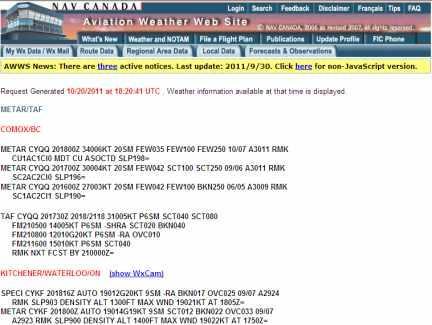
4 METAR: hourly weather report (issued on the hour); and SPECI: special weather observations issued at times other than on the hour, as a result of a significant weather change. METAR CYQQ Z 00000KT 20SM BKN025 BKN160 06/05 A3006 RMK SC3AC1 SLP179= SPECI CYKF Z AUTO 19011KT 9SM SCT008 BKN015 OVC021 09/ A2919 RMK MAX WND 21016KT AT 1305Z=
5 Airport Identifier INTERNATIONAL - 4 LETTERS EXAMPLE CYWG Winnipeg (C Canadian airport) KSEA Seattle, USA (K American airport) EDDT NZOA Berlin, Germany Omarama, New Zealand METAR CYQQ Z 00000KT 20SM BKN025 BKN160 06/05 A3006 RMK SC3AC1 SLP179= SPECI CYKF Z AUTO 19011KT 9SM SCT008 BKN015 OVC021 09/ A2919 RMK MAX WND 21016KT AT 1305Z=
6 Date and Time the date and time of the observation are always given in six digits, using universal coordinated time (UTC); Z 20 th day at 1400 (2pm) Zulu Z 20 th day at 1327 (1:37pm) Zulu Note: In BC, there is a 7 hour (daylight saving time) difference between pacific time and zulu time. Therefore 1400 is METAR CYQQ Z 00000KT 20SM BKN025 BKN160 06/05 A3006 RMK SC3AC1 SLP179= SPECI CYKF Z AUTO 19011KT 9SM SCT008 BKN015 OVC021 09/ A2919 RMK MAX WND 21016KT AT 1305Z=
7 Surface Winds Wind Direction - degrees true, always 3 digits to the nearest 10 degrees. If direction varies 60 or more and the mean speed exceeds 3 KTs, during the 10 minute period preceding the observation, it is reported 3 digits, the letter V and 3 more digits 00000KT 000 degrees T at 00 KT AUTO 19011G20KT Automated observation, 190 degrees T at 11 KT gusting to 20 KT METAR CYQQ Z 00000KT 20SM BKN025 BKN160 06/05 A3006 RMK SC3AC1 SLP179= SPECI CYKF Z AUTO 19011G20KT 9SM SCT008 BKN015 OVC021 09/ A2919 RMK MAX WND 21016KT AT 1305Z=
8 Prevailing Visibility Is the greatest visibility common to 1/2 or more of the horizontal circle (observation point); reported in statute miles and fractions 2 1/2SM 2.5 statute miles 9SM 9 statute miles METAR CYQQ Z 00000KT 2 1/2SM SCT004 BKN025 BKN160 06/05 A3006 RMK SC3AC1 SLP179= SPECI CYKF Z AUTO 19011G20KT 9SM SCT008 BKN015 OVC021 09/ A2919 RMK MAX WND 21016KT AT 1305Z=
9 Runway Visual Range RVR reported whenever prevailing visibility is 1 mile or less and/or the RVR is indicating 6,000 ft or less (10 minute average) R36L/4000FT/D Runway 36 left has a visual range of 4000 feet and the trend is decreasing R06/3000FT/U Runway 06 has a visual range of 3000 feet and the trend is upward METAR CYWG Z /4SM R36L/4000FT/D SCT004 BKN025 BKN160 06/05 A3006 RMK SC3AC1 SLP179= SPECI CYKF Z AUTO 19011G20KT 3/4SM R06/3000FT SCT008 BKN015 OVC021 09/ A2919 RMK MAX WND 21016KT AT 1305Z=
10 Present Weather Present weather is comprised of weather phenomena (precipitation, obscuration, or other phenomena) preceded by one or two qualifiers (intensity or proximity to the station and descriptor) Intensity modifier + Type of Weather - for light SN (snow) No modifier moderate RA (rain) + for heavy FG (fog) METAR CYWG Z /4SM -RA SCT004 BKN025 BKN160 06/05 A3006 RMK SC3AC1 SLP179=
11 Weather Abbreviations DESCRIPTORS SH SHOWERS BL BLOWING MI SHALLOW PR PARTIAL FZ FREEZING DR LOW DRIFTING BC PATCHES TS THUNDERSTORM PRECIPITATION RA RAIN DZ DRIZZLE IC ICE CRYSTALS PL ICE PELLETS SN SNOW SG SNOW GRAINS GR HAIL GS SNOW PELLETS UP UKNOWN PRECITATION (AWOS only)
12 OBSCURING PHENOMENA HZ HAZE SA SAND DU DUST FU SMOKE FG FOG (VSBY < 5/8) BR MIST (VSBY 5/8) VA VOLCANIC ASH OTHER +FC TORNADO or WATERSPOUT FC SS FUNNEL CLOUD SAND STORM +SS SAND STORM (VSBY < 5/16) DS DUSTSTORM +DS DUSTSTORM (VSBY < 5/16) SQ SQUALLS

13 Confirmation What type of weather is happening? METAR CYWG Z /4SM SHRA SCT004 BKN025 BKN160 06/05 A3006 RMK SC3AC1 SLP179= SPECI CYKF Z AUTO 19011G20KT 3/4SM -BLSN SCT008 BKN015 OVC021 00/M05 A2919 RMK MAX WND 21016KT AT 1305Z= METAR CYXU Z 19012G18KT 2SM -RADZ BR BKN005 OVC020 09/08 A2922 RMK SF6SF2 CIG RAG SLP897= SPECI CYZF Z 29003KT 1 1/2SM -SN VV002 00/ RMK SN8= METAR CYQQ Z 23018G25 5SM +TSRA BKN009 BKN025 OVC030 15/12 A2899 RMK CB5CB2TCU1=
14 Sky Condition The sky is divided into 8 segments, each called an okta Codes for sky cover amounts are: SKC Sky clear FEW... Few Trace to 2/8 SCT. Scattered 3/8 to 4/8 BKN Broken 5/8 to 7/8 OVC. Sky Overcast 8/8 Sky cover amounts are cumulative therefore, layer amounts include the sum of any layers below. A cloud ceiling is said to exist when the coverage symbol BKN or OVC is reported.
15 SCT004 BKN025 BKN160 scattered at 400 AGL, broken at 2500 AGL, broken at AGL BKN009 BKN025 OVC030 broken at 900 AGL, overcast at 3000 FEW100 few at AGL If clouds are low, height are given in a vertical visibility height Ex. VV002 vertical visibility of 200 AGL METAR CYWG Z /4SM SHRA SCT004 BKN025 BKN160 06/05 A3006 RMK SC3AC1 SLP179= METAR CYQQ Z 23018G25 5SM +TSRA BKN009 OVC030 15/12 A2899 RMK CB5TCU2=

16 Temperature/Dewpoint Temperature recorded in degrees Celsius M signifies a negative temperature temperature and dew point are separated by a slash (/) 06/05 Temperature 6 degrees/ dewpoint 5 degrees M07/M09 Temperature -7 degrees/ dewpoint -9 degrees METAR CYQQ Z 00000KT 2 1/2SM SCT004 BKN025 BKN160 06/05 A3006 RMK SC3AC1 SLP179= SPECI CMYKF Z AUTO 19011G20KT 9SM SCT008 BKN015 OVC021 M07/M09 A2919 RMK MAX WND 21016KT AT 1305Z=
17 Altimeter Setting A is the group identifier that indicates altimeter setting it is reported in inches of mercury Altimeter settings are given in hundredths of an inch of mercury. A Inches of mercury ( Hg) A Hg METAR CYQQ Z 00000KT 2 1/2SM SCT004 BKN025 BKN160 06/05 A3006 RMK SC3AC1 SLP179= SPECI CMYKF Z AUTO 19011G20KT 9SM SCT008 BKN015 OVC021 M07/M09 A2919 RMK MAX WND 21016KT AT 1305Z=
18 Remarks- RMK Includes the following information: - cloud layer type and opacity in eights of sky concealed - sea level pressure (SLP) in hectopascal (hpa); - other weather significant to aviation. RMK SC3AC1 SLP179= Remarks Stratocumulus 3 oktas, altocumulus 1 okta, sea level pressure mb METAR CYQQ Z 00000KT 2 1/2SM SCT004 BKN025 BKN160 06/05 A3006 RMK SC3AC1 SLP179= SPECI CMYKF Z AUTO 19011G20KT 9SM SCT008 BKN015 OVC021 M07/M09 A2919 RMK MAX WND 21016KT AT 1305Z=
19 RMK MAX WND 21016KT AT 1305Z SLP 995= Remarks: maximum wind is 210 degrees at 16 kt recorded at 1305Z. Sea level pressure 999.5mb Note on Sea level pressure: When the SLP is between 0 and 5 put 10 in front of the number SLP162 = mb When the SLP is between 6 and 9 put a 9 in front of the number SLP993 = 999.3mb
20 Remarks: Cloud abbreviations The following abbreviations are used for cloud types: CI cirrus ST stratus CS cirrostratus SF stratus fractus CC cirrocumulus SC stratocumulus AS altostratus CU cumulus AC altocumulus CUFRA cumulus fractus NS nimbostratus TCU towering cumulus CB cumulonimbus ACC altocumulus castellanus
21 What else might you see in the remarks? RE identifies the group weather phenomena that was observed during the hour since the last METAR but not at the time of observation. REFZRA = recent freezing rain WS identifies wind shear up to 1600 AGL WS All RWY = wind shear on all runways WS RWY 20R = wind shear on runway 20 right Note on METAR: you will see many other abbreviations. Often add in some vowels and you should be able to figure out the word
22 Confirmation Decode the following: METAR CYTR Z 12003KT 2 1/2SM BR OVC013 03/03 A2982 RMK SC8 SLP023 METAR CYYZ Z 11003KT 1/8SM R06/1200FT/D -RADZ FG VV002 04/04 A2976 RMK FG8 SLP 001 SPECI CYYZ Z 12006KT 3SMBR OVC008 RMK ST8 METAR CYYC Z 05008KT 20SM FEW018 BKN057 OVC080 05/01 A2986 RMK SC2SC5AC1 SLP147
")
23 Resources For more practise: Look in the FTGU pg Check out the aviation weather website (google AWWS)

24 Resources Type in the airport identifier or search for it Then select for it to be in standard METAR language or text. Do both to help you learn
25 Resources

26 Automated Weather Observation System
Meteorology METARs Weather Observing Stations. MTPs: 5.09 METARs References: FTGU pages AWWS:
 Meteorology 5.09 References: FTGU pages 160-163 AWWS: www.flightplanning.navcanada.ca MTPs: Weather Observing Stations 5.09 Weather Observing Stations Weather observation are taken every hour at selected
Aviation Weather Reports
 Aviation Weather Reports Aviation Weather Reports METAR: hourly weather report (issued on the hour every hour) SPECI: special weather observations issued at times other than on the hour, as a result of
TAF CCCC YYGGggZ YYHHHH dddff(f)gffkt VVVVSM [ww NNNhhh] [Wshhh/dddffKT] [TTTTT xxxx] repeated as needed
![TAF CCCC YYGGggZ YYHHHH dddff(f)gffkt VVVVSM [ww NNNhhh] [Wshhh/dddffKT] [TTTTT xxxx] repeated as needed](/thumbs/80/81003809.jpg "TAF CCCC YYGGggZ YYHHHH dddff(f)gffkt VVVVSM [ww NNNhhh] [Wshhh/dddffKT] [TTTTT xxxx] repeated as needed") Encoding TAFs Terminal Aerodome Forecast (TAF) Terminal forecasts for the world follow an internationally accepted format. The TAFs are issued four times daily for 24 hour periods beginning at 00Z, 06Z,
Encoding TAFs Terminal Aerodome Forecast (TAF) Terminal forecasts for the world follow an internationally accepted format. The TAFs are issued four times daily for 24 hour periods beginning at 00Z, 06Z,
KEY TO DECODING THE U.S. METAR OBSERVATION REPORT
 KEY TO DECODING THE U.S. METAR OBSERVATION REPORT Example METAR Report METAR KABC 121755Z AUTO 21016G24KT 180V240 1SM R11/P6000FT -RA BR BKN015 0VC025 06/04 A2990 RMK A02 PK WND 20032/25 WSHFT 1715 VIS
Aerodrome Forecast (TAF)
") AVIATION WEATHER PRODUCTS () Bureau of Meteorology Aviation Weather Services A is a coded statement of meteorological conditions expected at an and within a radius of five nautical miles of the reference
AVIATION WEATHER PRODUCTS () Bureau of Meteorology Aviation Weather Services A is a coded statement of meteorological conditions expected at an and within a radius of five nautical miles of the reference
TAF Decoder Courtesy of the Aviation Weather Center
 TAF Decoder Courtesy of the Aviation Weather Center A Terminal Aerodrome Forecast (TAF) is a concise statement of the expected meteorological conditions at an airport during a specified period (usually
Aerodrome Reports and Forecasts
 Aerodrome Reports and Forecasts A Users Handbook to the Codes WMO-No. 782 Aerodrome Reports and Forecasts A Users Handbook to the Codes WMO-No. 782 Fifth edition November 2008 WMO-No. 782 World Meteorological
Explanation and decode for code figures used in the Wokingham 0900 and 1500 GMT observations
 Appendix 2. Explanation and decode for code figures used in the Wokingham 0900 and 1500 GMT observations VV : Visibility. Code figures 00 to 50 are in km and tenths e.g. 01 = 0.1 km = 100 m, 33 = 3.3 km,
Issue of SIGMET/AIRMET warning
 Issue of SIGMET/AIRMET warning 1 Presentation Objectives After this presentation session you will be able to: Warn for Hazardous weather phenomena using the correct ICAO coding with regards to SIGMET/AIRMET
CHAPTER 9 - SPECIAL OBSERVATIONS
 CHAPTER 9 - AL OBSERVATIONS 9.1 Introduction This chapter explains the criteria for taking special observations (). 9.2 Special Observations s are taken whenever mandatory criteria are met, and at the
ROYAL CANADIAN AIR CADETS PROFICIENCY LEVEL FOUR INSTRUCTIONAL GUIDE SECTION 5 EO C ANALYZE WEATHER INFORMATION PREPARATION
 ROYAL CANADIAN AIR CADETS PROFICIENCY LEVEL FOUR INSTRUCTIONAL GUIDE SECTION 5 EO C436.03 ANALYZE WEATHER INFORMATION Total Time: 90 min PREPARATION PRE-LESSON INSTRUCTIONS Resources needed for the delivery
Wind direction measures in degrees Occasion described with codes, when is calm or variable wind. Explanation
 Introduction The searching results explanations of meteorological data Depending on the parameter, the instrumental measuring or visual observation method is used for the meteorological observations. Instrumentally
Atmospheric Pressure. Pressure Altimeter. Pressure Altimeter
 Atmospheric Pressure The : An instrument to measure altitude based on an aneroid barometer. It can be adjusted for changes in atmospheric pressure 1 2 Altimeter Setting Is not SLP, but close to it. If
MACIS documentation. a. Temporal resolution: For each month and the hole year
 MACIS documentation Wind: 1. Relative frequency of mean wind speed b. Treshold values: mean wind speed greater, greater equal, less, less equal 3, 5, 10, 12, 15 20, 22, 25 kt 2. Relative frequency of gusts
TERMINAL AERODROME FORECAST
 1. Introduction TERMINAL AERODROME FORECAST Basically, a Terminal Aerodrome Forecast (or Terminal Area Forecast, TAF) is a message with a defined format with the objective to report a weather forecast
Preflight Weather Analysis Lesson 4 Part 4 of 4
 Preflight Weather Analysis Lesson 4 Part 4 of 4 Presented by Find-it Fast Books Unlimited FREE Downloads of this course available at www.finditfastbooks.org 1 The slide sequence for Lesson 4 is a little
METEOROLOGICAL AIRPORT REPORT
 1. Introduction 1.1. METAR IVAO TM Training Department Headquarters METEOROLOGICAL AIRPORT REPORT A METAR (Meteorological Airport Report) is a meteorological observation report (not a prediction) dedicated
Atmospheric Moisture. Atmospheric Moisture:Clouds. Atmospheric Moisture:Clouds. Atmospheric Moisture:Clouds
 Sec A Atmospheric Moisture I. Measuring Relative Humidity A. A Psychrometer is an instrument for measuring relative humidity B. A common psychrometer uses two thermometers with a wet gauze wrapped over
ESCI 241 Meteorology Lesson 9 Clouds and Fog
 References and Reading: MT Chapter 7 FORMATION OF CLOUDS ESCI 241 Meteorology Lesson 9 Clouds and Fog When air becomes saturated with water vapor, any excess water vapor condenses to form clouds The air
AERODROME METEOROLOGICAL OBSERVATION AND FORECAST STUDY GROUP (AMOFSG)
") AMOFSG/9-SN No. 31 22/8/11 AERODROME METEOROLOGICAL OBSERVATION AND FORECAST STUDY GROUP (AMOFSG) NINTH MEETING Montréal, 26 to 30 September 2011 Agenda Item 5: Observing and forecasting at the aerodrome
AMOFSG/9-SN No. 31 22/8/11 AERODROME METEOROLOGICAL OBSERVATION AND FORECAST STUDY GROUP (AMOFSG) NINTH MEETING Montréal, 26 to 30 September 2011 Agenda Item 5: Observing and forecasting at the aerodrome
5.04 Clouds and Fog. References: FTGU pages , 147. Meteorology
 5.04 Clouds and Fog References: FTGU pages 124-126, 147 Meteorology 5.04 Clouds and Fog MTPs: Cloud Classification Types and Recognition Associated Precipitation Fog Formation and Types Cloud Classification
Aerodrome Weather Observer
 Aerodrome Weather Observer METARAWS/SPECIAWS Reporting and Recording Bureau of Meteorology Training Centre Commonwealth of Australia 2016 This work is copyright. Apart from any use as permitted under the
data manipulation (2)
") Information Science in Action Week 06 data manipulation (2) College of Information Science and Engineering Ritsumeikan University last week: data manipulation (1) the evolution of protocols push vs. pull
Information Science in Action Week 06 data manipulation (2) College of Information Science and Engineering Ritsumeikan University last week: data manipulation (1) the evolution of protocols push vs. pull
Meteorology Clouds and Fog. Cloud Classification MTPs: Height. Shape. and. Clouds are classified by:
 Meteorology 5.04 Clouds and Fog References: FTGU pages 124-126, 147 5.04 Clouds and Fog MTPs: Cloud Classification Associated Precipitation Clouds are classified by: Cloud Classification Height Shape and
Effective: SPECI ALERTING
 AUSTRALIA AERONAUTICAL INFORMATION SERVICE AIRSERVICES AUSTRALIA GPO BOX 367, CANBERRA ACT 2601 Phone: 02 6268 4874 Email: aim.editorial@airservicesaustralia.com Effective: AERONAUTICAL INFORMATION CIRCULAR
National Climatic Data Center DATA DOCUMENTATION FOR. DATA SET 3280 (DSI-3280) Surface Airways Hourly. May 4, 2005
 Surface Airways Hourly. May 4, 2005") National Climatic Data Center DATA DOCUMENTATION FOR DATA SET 3280 (DSI-3280) Surface Airways Hourly May 4, 2005 National Climatic Data Center 151 Patton Ave. Asheville, NC 28801-5001 USA Table of Contents
National Climatic Data Center DATA DOCUMENTATION FOR DATA SET 3280 (DSI-3280) Surface Airways Hourly May 4, 2005 National Climatic Data Center 151 Patton Ave. Asheville, NC 28801-5001 USA Table of Contents
Global Surface Archives Documentation
 Global Surface Archives Documentation 1 July 2013 PO BOX 450211 GARLAND TX 75045 www.weathergraphics.com Global Surface Archives is a dataset containing hourly and special observations from official observation
現在天候 (Present weather)(wmo 4501)
(wmo 4501)") 現在天候 (Present weather)(wmo 4501) Based on WMO 4501 for recording present weather ( 更新日 : 平成 19 年 5 月 9 日 ) L0 L1 L2 L3 L4 L5 L6 L7 L8 L9 Clear(No cloud at any level) Partly cloudy(scattered or broken)
現在天候 (Present weather)(wmo 4501) Based on WMO 4501 for recording present weather ( 更新日 : 平成 19 年 5 月 9 日 ) L0 L1 L2 L3 L4 L5 L6 L7 L8 L9 Clear(No cloud at any level) Partly cloudy(scattered or broken)
GEMPAK Symbols, Lines, and Markers APPENDIX C. SYMBOLS, LINES, and MARKERS. Past Weather. Pressure tendency with change.
 APPENDIX C SYMBOLS, LINES, and MARKERS SYMBOLS The World Meteorological Organization (WMO) has established a standard set of symbols depicting descriptive reports of certain types of weather observations.
Decoding Observations and Terminal Aerodrome Forecasts. Weather Observer/Forecaster O-LD 18 th Weather Squadron Ft Polk, LA
 Decoding Observations and Terminal Aerodrome Forecasts Weather Observer/Forecaster O-LD 18 th Weather Squadron Ft Polk, LA Part I. Decoding Observations What types of data goes into a weather observation?
WMO Aeronautical Meteorology Scientific Conference 2017
 Session 2 Integration, use cases, fitness for purpose and service delivery 2.2 Terminal Area and Impact-based forecast Data-driven influence model of weather condition in airport operational performance
2. A mountain breeze (katabatic wind) blows : DOWN THE SLOPE DURING THE NIGHT
 blows : DOWN THE SLOPE DURING THE NIGHT") MODEL E-EXAM (ATPL) NO.3 1. Among the ten groups of clouds, the following two are mentioned specifically in MET-reports and forecasts intended for aviation: CUMULONIMBUS AND TOWERING CUMULUS 2. A mountain
MODEL E-EXAM (ATPL) NO.3 1. Among the ten groups of clouds, the following two are mentioned specifically in MET-reports and forecasts intended for aviation: CUMULONIMBUS AND TOWERING CUMULUS 2. A mountain
Work Package 1: Final Project Report Appendix E: The METAR data
 Work Package 1: Final Project Report Appendix E: The METAR data First Assessment of the operational Limitations, Benefits & Applicability for a List of package I AS applications FALBALA Project Drafted
Appendix. Atmosphere Investigation Data Work Sheet. Ozone Data Work Sheet. Atmospheric Haze Data Work Sheet. Clouds 7 Measurement Data Work Sheet
 Appendix Atmosphere Investigation Data Work Sheet Ozone Data Work Sheet Atmospheric Haze Data Work Sheet Clouds 7 Measurement Data Work Sheet GLOBE 2000 Appendix - 1 Atmosphere Atmosphere Investigation
THE METAR & TAF QUICK REFERENCE MANUAL. ebook Series Version 1.3. Copyright 2012 Find-it Fast Books
 THE METAR & TAF QUICK REFERENCE MANUAL ebook Series Version 1.3 Copyright 2012 Find-it Fast Books No part of this ebook, or in its entirety, may be reproduced or retransmitted by any electronic or mechanical
Air Traffic Control Weather Certification
 3 d Weather Squadron Air Traffic Control Weather Certification Mr B.J. Ortner, 3 WS/DOV Weather Forecaster Current as of: 8 June 2017 Overview Requirements/References RGAAF (KGRK) Observations HAAF (KHLR)
9999= letters "blocks".
 METAR Learning Goals METAR/TAF Weather Report HECA 290925Z 04009KT 010V070 7000 DZRA FEW006 SCT010 BKN022 19/12 Q1008 BECMG 9999= What what what what?????? Wow, I don't understan nd this. All I see is
LAPL/PPL question bank FCL.215, FCL.120 Rev METEOROLOGY 050
 LAPL/PPL question bank FCL.215, FCL.120 Rev. 1.7 11.10.2018 METEOROLOGY 050 1 Below the tropopause, the ICAO Standard Atmosphere (ISA) assumes? A mean sea level pressure of 1225g/m³ together with a mean
METEOROLOGY CLASS #1 LT LAZARUK AND WO2 LUCAS LAMOUREUX
 METEOROLOGY CLASS #1 LT LAZARUK AND WO2 LUCAS LAMOUREUX CLASS #1 OVERVIEW WHAT WILL YOU BE LEARNING AN INTRODUCTION THE ATMOSPHERE CLOUDS STABILITY TEMPERATURE & HUMIDITY INTRODUCTION PART 1 INTRODUCTION
LAPL(A)/PPL(A) question bank FCL.215, FCL.120 Rev METEOROLOGY 050
/PPL(A) question bank FCL.215, FCL.120 Rev METEOROLOGY 050") METEOROLOGY 050 1 Below the tropopause, the ICAO Standard Atmosphere (ISA) assumes? A mean sea level pressure of 1013.25 hpa together with a mean sea level temperature of 15 C, decreasing by 1.98 C per
METEOROLOGY 050 1 Below the tropopause, the ICAO Standard Atmosphere (ISA) assumes? A mean sea level pressure of 1013.25 hpa together with a mean sea level temperature of 15 C, decreasing by 1.98 C per
Manual on Codes. Regional Codes and National Coding Practices Volume II edition Updated in 2017 WEATHER CLIMATE WATER. WMO-No.
 Manual on Codes Regional Codes and National Coding Practices Volume II 2011 edition Updated in 2017 WEATHER CLIMATE WATER WMO-No. 306 Manual on Codes Regional Codes and National Coding Practices Volume
Section 7: Hazard Avoidance
 7.1 In-Flight Hazard Awareness Section 7: Hazard Avoidance As technology improves, pilots have more and more real-time information within reach in all phases of flight. Terrain proximity, real-time weather
NATS 101 Section 13: Lecture 11. Clouds
 NATS 101 Section 13: Lecture 11 Clouds Cloud Classification Luke Howard (English naturalist) developed a system in 1803 that employed Latin words to describe clouds as they appear to a ground observer.
GEN 3.5 METEOROLOGICAL SERVICES
 AIP GEN 3.5-1 GEN 3.5 METEOROLOGICAL SERVICES 1. RESPONSIBLE SERVICE The meteorological services for civil aviation at Jordan are provided by the Jordanian Meteorological Department. Postal Address: Director
Meteorology. Types of Turbulence
 Meteorology 5.06 Turbulence, Visibility, and Fronts References: Air Command Weather Manual Chapters 7, 8, 10 and 11 FTGU pages 133, 138, 140-145, 147, 155 and 156 Aviation Weather Student Guide http://www.tpub.com/content/aviation2/p-303/index.htm
Appendix X for CAP 437 Offshore Helicopter Landing Areas Guidance on Standards.
 Appendix X for CAP 437 Offshore Helicopter Landing Areas Guidance on Standards. Additional Guidance relating to the provision of Meteorological Information from Offshore Installations 1. Introduction This
ERTH 465 Fall Laboratory Exercise 5. Surface Weather Observations (METARS) and Frontal Analysis (300 pts)
 and Frontal Analysis (300 pts)") ERTH 465 Fall 2017 Laboratory Exercise 5 Surface Weather Observations (METARS) and Frontal Analysis (300 pts) Insert in ringed-three hole binder. Point deductions for sloppy or late work. Due date: Tuesday
ERTH 465 Fall 2017 Laboratory Exercise 5 Surface Weather Observations (METARS) and Frontal Analysis (300 pts) Insert in ringed-three hole binder. Point deductions for sloppy or late work. Due date: Tuesday
Observing Climate - Upper Air
 Observing Climate - Upper Air 3-1 Water (Con t) Clouds Types - Classification Base height Coverage Science Concepts Definition The Earth System (Kump, Kastin & Crane) Chap. 3 (pp. 48-49) 3-2 What do we
CIRROCUMULUS CIRROSTRATUS
 Ten Basic Clouds Based on his observations, Luke Howard suggested there were modifications (or combinations) of the core four clouds between categories. He noticed that clouds often have features of two
QLD-S NSW-E NSW-W VIC TAS. A HEADER giving details of the time of issue and the associated validity period.
 FLIGHT FORECASTS Flight Forecasts are issued on request for flights for which GAFs are not available. They are subject to the requirements of AIP GEN 3.5 para 3.1 and AIP GEN 3.5 para 10.3. Flight forecasts
Syllabus details and associated Learning Objectives (A) and EIR METEOROLOGY
 and EIR METEOROLOGY") Syllabus details associated Learning Objectives 050 00 00 00 METEOROLOGY 050 01 00 00 THE ATMOSPHERE 050 01 02 00 Air temperature 050 01 02 04 Lapse rates LO Describe qualitatively quantitatively the temperature
Syllabus details associated Learning Objectives 050 00 00 00 METEOROLOGY 050 01 00 00 THE ATMOSPHERE 050 01 02 00 Air temperature 050 01 02 04 Lapse rates LO Describe qualitatively quantitatively the temperature
AERODROME METEOROLOGICAL OBSERVATION AND FORECAST STUDY GROUP (AMOFSG)
") MOFSG/8-SN No. 31 22/12/09 EROROME METEOROLOGIL OSERVTION N FOREST STUY GROUP (MOFSG) EIGHTH MEETING Melbourne, ustralia, 15 to 18 February 2010 genda Item 5: Observing and forecasting at the aerodrome
MOFSG/8-SN No. 31 22/12/09 EROROME METEOROLOGIL OSERVTION N FOREST STUY GROUP (MOFSG) EIGHTH MEETING Melbourne, ustralia, 15 to 18 February 2010 genda Item 5: Observing and forecasting at the aerodrome
Condensation: Dew, Fog, & Clouds. Chapter 5
 Condensation: Dew, Fog, & Clouds Chapter 5 The Formation of Dew & Frost Dew forms on objects near the ground surface when they cool below the dew point temperature. More likely on clear nights due to increased
Bell Ringer. 1. What is humidity? 2. What kind of clouds are there outside right now? 3. What happens to air when it gets colder?
 Bell Ringer 1. What is humidity? 2. What kind of clouds are there outside right now? 3. What happens to air when it gets colder? Cloud Notes What are clouds? A cloud is made up of tiny water droplets and/or
STUDY UNIT SEVENTEEN GRAPHICAL AIRMAN S METEOROLOGICAL ADVISORY (G-AIRMET)
") STUDY UNIT SEVENTEEN GRAPHICAL AIRMAN S METEOROLOGICAL ADVISORY (G-AIRMET) 341 (10 pages of outline) 17.1 Product Description....................................................... 341 17.2 Issuance...............................................................
STUDY UNIT SEVENTEEN GRAPHICAL AIRMAN S METEOROLOGICAL ADVISORY (G-AIRMET) 341 (10 pages of outline) 17.1 Product Description....................................................... 341 17.2 Issuance...............................................................
6.2 Meteorology. A meteorologist is a person who uses scientific principles to explain, understand, observe, or forecast Earth s weather.
 Water and Weather 6.2 Meteorology A meteorologist is a person who uses scientific principles to explain, understand, observe, or forecast Earth s weather. 6.2 Water in the Atmosphere Dew point is the temperature
Meteorology. Review Extreme Weather a. cold front. b. warm front. What type of weather is associated with a:
 Meteorology 5.08 Extreme Weather References: FTGU pages 132, 144, 145, 148-155 Air Command Weather Manual Chapters 9 and 15 Review What type of weather is associated with a: a. cold front b. warm front
Chapter 12 Weather Charts & Briefings: PIREPS, Progs & METARS
 Chapter 12 Weather Charts & Briefings: PIREPS, Progs & METARS The Telephone Briefing 1. [12-4/1/9] When telephoning a weather briefing facility for preflight weather information, pilots should A. identify
CLOUDS & THUNDERSTORMS
 Funding provided by NOAA Sectoral Applications Research Project CLOUDS & THUNDERSTORMS Basic Climatology Oklahoma Climatological Survey How are clouds made? Clouds form when air is cooled to its dewpoint
Unit: Weather Study Guide
 Name: Period: Unit: Weather Study Guide Define each vocabulary word on a separate piece of paper or index card. Weather Climate Temperature Wind chill Heat index Sky conditions UV index Visibility Wind
Cloud Formation and Classification
 Cloud Formation and Classification Cloud Formation clouds form when air above the surface cools below the dew point condensation nuclei small particles in the atmosphere around which water droplets can
1 AOS 452 Lab 1: Meteorological data decoding and forecast preparation
 1 AOS 452 Lab 1: Meteorological data decoding and forecast preparation This semester we will be using a variety of programs and software specific to meteorology. The first program we will focus on is:
AVIATION WEATHER SERVICES GUIDE
 AVIATION WEATHER SERVICES GUIDE For Aviation Users Contents Page 1 Page 2 Revised: May 2017 Contents Introduction 1 Aviation Weather Services 2 Pilot Briefing Service (PBS)... 2 Aviation Weather Web Site
NATS 1750 Lecture. Wednesday 28 th November Pearson Education, Inc.
 NATS 1750 Lecture Wednesday 28 th November 2012 Processes that lift air Orographic lifting Elevated terrains act as barriers Result can be a rainshadow desert Frontal wedging Cool air acts as a barrier
National Transportation Safety Board Office of Aviation Safety Washington, D.C December 10, 2012 WEATHER STUDY DCA13RA025
 A. ACCIDENT National Transportation Safety Board Office of Aviation Safety Washington, D.C. 20594-2000 December 10, 2012 WEATHER STUDY DCA13RA025 Location: Monterrey, Mexico Date: December 9, 2012 Time:
SAMPLE ASSESSMENT TASKS AVIATION ATAR YEAR 12
 SAMPLE ASSESSMENT TASKS AVIATION ATAR YEAR 12 Copyright School Curriculum and Standards Authority, 2015 This document apart from any third party copyright material contained in it may be freely copied,
Weather Charts And Briefings
 Page M1 Chapter Thirteen Weather Charts And Briefings PIREPS, Progs & METARS The Telephone Briefing 1. [M4/1/9] When telephoning a weather briefing facility for preflight weather information, pilots should
MET 3502 Synoptic Meteorology. Lecture 5: Surface Weather Elements
 MET 3502 Synoptic Meteorology Lecture 5: Surface Weather Elements Surface Weather Elements Not observations of the surface, but Observations made by an observer (or instrument) at the surface Example:
RECCO Observation Decoding
 Monday, September 13, 1999 Decoding RECCO Reports Page: 1 RECCO Observation Decoding Reconnaissance reports are simple one- or two-line blocks of data in a numeric code. They are normally sent every 30
Clouds. What they tell us about the weather
 Clouds What they tell us about the weather Spring funnel cloud over Willard, Utah 2003 Cloud coverage 581-586 How to show Cloud Coverage On a weather map meteorologists use circles shaded differently to
Subject No 8 - PPL Meteorology
 Subject No 8 - PPL Meteorology Notes: This syllabus is principally based on the meteorology as applicable to flying a single piston-engine General Aviation type aeroplane or helicopter, within New Zealand
The Informed Scheduler
 The Informed Scheduler Thursday, January 21, 2016 1:00 p.m. 2:30 p.m. PRESENTED BY: Vinton Brown, Flight Safety International James M. Kohler, Chief Pilot, DuPont Andrew M. Bourland, CAM, Chief Pilot,
777 Neptune Groundschool Weather reporting & forecasts
 777 Neptune Groundschool 2018 Weather reporting & forecasts Weather Reporting Weather Forecast is a prediction of what the weather conditions will be in the future Weather Report tells the reader of what
METEOROLOGICAL SERVICES
 AIP New Zealand GEN 3.5-1 GEN 3.5 METEOROLOGICAL SERVICES 1 RESPONSIBLE SERVICE 1.1 Civil Aviation Authority 1.1.1 The Civil Aviation Authority is the meteorological authority for New Zealand and is responsible
Clouds (modified for ADEED)
") (modified for ADEED) Overview: Various features define the three main types of clouds: cumulus, cirrus, and stratus. One of those features is height. In this activity, students will learn to identify clouds
(modified for ADEED) Overview: Various features define the three main types of clouds: cumulus, cirrus, and stratus. One of those features is height. In this activity, students will learn to identify clouds
QA/QC of Aleutian Buoy and Airport Observation Data
 QA/QC of Aleutian Buoy and Airport Observation Data Background Document prepared by Uwe Gramann, P.Met. Mountain Weather Services Smithers, BC October 212 Airport Data Comments: Dataset includes hourly
1 of 5 20/01/2015 2:05 PM
 1 of 5 20/01/2015 2:05 PM AWWS News : There are 2 active notices. Last update: 2014/09/17 Request Generated 01/20/2015 at 22:01:08 UTC. Weather information available at that time is displayed. Go to a
The enduring fog and low cloud episode of 5-10 December 2015: Big Bubble Fog Trouble
 1. Overview The enduring fog and low cloud episode of 5-10 December 2015: Big Bubble Fog Trouble By Richard H. Grumm National Weather Service State College, PA An enduring low cloud and fog episode affected
GRAPHICAL AREA FORECASTS (GAF) feet. Flight Information Region boundary QLD-S NSW-E VIC TAS
 feet. Flight Information Region boundary QLD-S NSW-E VIC TAS") GRAPHICAL AREA FORECASTS (GAF) Unlike at TAF, a Graphical Area Forecasts (GAFs) does not describe conditions expected at a particular location, it refers to a defined area and is intended for use in planning
GRAPHICAL AREA FORECASTS (GAF) Unlike at TAF, a Graphical Area Forecasts (GAFs) does not describe conditions expected at a particular location, it refers to a defined area and is intended for use in planning
1 AOS 452 Lab 1: Meteorological data decoding and forecast preparation
 1 AOS 452 Lab 1: Meteorological data decoding and forecast preparation This semester we will be using a variety of programs and software specific to meteorology. The first program we will focus on is:
METEOROLOGY PANEL (METP) WORKING GROUP- METEOROLOGICAL OPERATION GROUP (MOG) FIRST MEETING
 WORKING GROUP- METEOROLOGICAL OPERATION GROUP (MOG) FIRST MEETING") 8 28/7/15 METEOROLOGY PANEL (METP) WORKING GROUP- METEOROLOGICAL OPERATION GROUP (MOG) FIRST MEETING Gatwick, United Kingdom, 08 to 11 September 2015 Agenda Item 3: Matters relating to SADIS 3.3: Operations
8 28/7/15 METEOROLOGY PANEL (METP) WORKING GROUP- METEOROLOGICAL OPERATION GROUP (MOG) FIRST MEETING Gatwick, United Kingdom, 08 to 11 September 2015 Agenda Item 3: Matters relating to SADIS 3.3: Operations
I d e n t i f i c a t i o n
 SKY WATCHERS GUIDE TO Cloud I d e n t i f i c a t i o n For more information on weather and additional teaching resources, please visit www.on.ec.gc.ca/skywatchers Clouds themselves will give you clues
FOLLOW-UP OF AMOFSG/8 ACTION AGREED (AC) Status on 12 April = completed
 Status on 12 April = completed") FOLLOW-UP OF AMOFSG/8 ACTION AGREED (AC) Status on 12 April 2011 = completed No. 8/1 Rationale for the use of the term "decision height" the Secretary investigates the rationale behind the need for information
FOLLOW-UP OF AMOFSG/8 ACTION AGREED (AC) Status on 12 April 2011 = completed No. 8/1 Rationale for the use of the term "decision height" the Secretary investigates the rationale behind the need for information
9 Condensation. Learning Goals. After studying this chapter, students should be able to:
 9 Condensation Learning Goals After studying this chapter, students should be able to: 1. explain the microphysical processes that operate in clouds to influence the formation and growth of cloud droplets
FEDERAL CLIMATE COMPLEX DATA DOCUMENTATION FOR INTEGRATED SURFACE DATA
 FEDERAL CLIMATE COMPLEX DATA DOCUMENTATION FOR INTEGRATED SURFACE DATA September 30, 2011 National Climatic Data Center Air Force Combat Climatology Center Fleet Numerical Meteorology and Oceanography
Unit 4 Lesson 2 Clouds and Cloud Formation. Copyright Houghton Mifflin Harcourt Publishing Company
 Head in the Clouds What are clouds? A cloud is a collection of small water droplets or ice crystals that are suspended in the air. Clouds are visible because water droplets and ice crystals reflect light.
Chapter 5: Forms of Condensation and Precipitation. Copyright 2013 Pearson Education, Inc.
 Chapter 5: Forms of Condensation and Precipitation Water vapor's role in the Earth's weather is major. Its the product of evaporation. It is lifted up, condenses and forms clouds. It is also a greenhouse
Sources of Hourly Surface Data and Weather Maps for the U.S.
 Sources of Hourly Surface Data and Weather Maps for the U.S. Weather Underground Weather Underground http://www.wunderground.com/history/ maintains a deep archive of hourly reports for around the world.
Condensation Nuclei. Condensation Nuclei 2/10/11. Hydrophobic Water-repelling Oils, gasoline, paraffin Resist condensation, even above 100% RH
 Chapter 5 The Formation of Dew & Frost Dew forms on objects near the ground surface when they cool below the dew point temperature. More likely on clear nights due to increased radiative cooling White
9/22/14. Chapter 5: Forms of Condensation and Precipitation. The Atmosphere: An Introduction to Meteorology, 12 th.
 Chapter 5: Forms of Condensation and Precipitation The Atmosphere: An Introduction to Meteorology, 12 th Lutgens Tarbuck Lectures by: Heather Gallacher, Cleveland State University! A cloud is a visible
Cloud: Type. Cloud Shapes
 Classification Cloud: Type Clouds: Aggregate of ice or water droplets 1. Appearance a. Cirrus-wispy/curl of hair b. Stratus-sheet-like/layer c. Cumulus-puffy/heap d. Nimbo- or -nimbus: producing rain 2.
Identify and describe clouds in the low, middle, and upper levels of the atmosphere. Relate these to specific types of weather.
 5. Cloud Types. Identify and describe clouds in the low, middle, and upper levels of the atmosphere. Relate these to specific types of weather. Clouds and Preciipitation CIRRUS 32.800 FEET CIRROCUMULUS
EnergyPlus Weather File (EPW) Data Dictionary
 Data Dictionary") EnergyPlus Weather File (EPW) Data Dictionary The data dictionary for EnergyPlus Weather Data is shown below. Note that semi-colons do NOT terminate lines in the EnergyPlus Weather Data. It helps if you
EnergyPlus Weather File (EPW) Data Dictionary The data dictionary for EnergyPlus Weather Data is shown below. Note that semi-colons do NOT terminate lines in the EnergyPlus Weather Data. It helps if you
24.2 Cloud Formation 2/3/2014. Orographic Lifting. Processes That Lift Air Frontal Wedging. Convergence and Localized Convective Lifting
 2/3/2014 Orographic Lifting Processes That Lift Air Frontal Wedging A front is the boundary between two adjoining air masses having contrasting characteristics. Convergence and Localized Convective Lifting
What does a raindrop look like as it is falling? A B C
 What does a raindrop look like as it is falling? A B C As the raindrop falls, it bumps into air molecules, flattening out the bottom of the drop! Force or air resistance Force of gravity Water can be in
Accuracy in Predicting GDPs and Airport Delays from Weather Forecast Data
 Accuracy in Predicting GDPs and Airport Delays from Weather Forecast Data David Smith Center for Air Transportation Systems Research George Mason University Fairfax, VA September 6, 2007 CENTER FOR AIR
AVIATION WEATHER STUDENT GUIDE
 NAVAL AIR TRAINING COMMAND NAS CORPUS CHRISTI, TEXAS CNATRA P-770 (New 07-15) AVIATION WEATHER STUDENT GUIDE PRIMARY 2015 AVIATION WEATHER STUDENT GUIDE PRIMARY P-770 iii THIS PAGE INTENTIONALLY LEFT
WEATHER. rain. thunder. The explosive sound of air as it is heated by lightning.
 WEATHER rain thunder The explosive sound of air as it is heated by lightning. rainbow lightning hurricane They are intense storms with swirling winds up to 150 miles per hour. tornado cold front warm front
Condensation: Dew, Fog and Clouds AT350
 Condensation: Dew, Fog and Clouds AT350 T=30 C Water vapor pressure=12mb What is Td? What is the sat. water vapor T=30 C Water vapor pressure=12mb What is Td? What is the sat. water vapor ~12/42~29% POLAR
MANOBS. Manual of Surface Weather Observations. Seventh Edition, Amendment 19
 MANOBS Manual of Surface Weather Observations Seventh Edition, Amendment 19 April 2015 Originating Authority: Monitoring and Data Services Directorate ISBN: 978-1-100-25445-6 Cat No.: En56-238/2-2015E-PDF