Stormwater Work Projects 2013
|
|
|
- Christiana Manning
- 5 years ago
- Views:
Transcription
1 Stormwater Work Projects 2013

2 Pound Ln. A customer called in a complaint that every >me it rained, his driveway was flooded from the water coming off the roadway. Driveway

3 Pound Ln.

4 Pound Ln.

5 16 th Ave. A customer complaint was received that water had been flooding out the storage units and residence on the north side of 16 th Ave.

6 16 th Ave. A water conduc>vity test was performed to determine the exact course of the water, and to what extent it would have to be diverted.

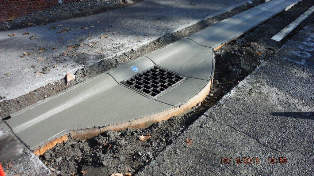
7 16 th Ave. In addi>on, across the road we also had an issue with an exis>ng storm drain. The drain had chronic problems of filling with sediment and debris washed down from the Ashley ditch line. Drain Grate

8 16 th Ave. From the field informa>on gathered, MaP was able to develop a plan for the proposed asphalt berm and swale installa>on.

9 With the help of the Road Crew, we proceeded to install the berm and swale.

10 16 th Ave.

11 16 th Ave.

12 16 th Ave. Finally we returned to the area and excavated an area at the end of the berm. This area was then refilled with coarse drain rock for the ousall.

13 Hallgren Dr. The problem is obvious by the picture. On the leu side of the photo there is an exis>ng catch basin which pipes across the road to the west. The water is obviously not making it to the exis>ng drain. Exis>ng basin On the right side of the photo there is no drainage, and this pond persists in front of this residence every >me it rains.

14 Hallgren Dr. We u>lized the exis>ng underground piping and excavated an area above it across the road. Underground piping

15 Hallgren Dr. A custom concrete form was constructed to pour a short basin above the pipe. AUer pouring of the basin, the top half of the piping was cut, essen>ally crea>ng another in line basin.

16 Hallgren Dr. AUer comple>ng the basin, we shot grade on both sides of the roadway and hand graded to flow to the basins.

17 Rolling Hills Ln. A resident was having issues with water shee>ng across the road and being diverted down his retaining wall and onto his property. AUer surveying the site, it was determined that a berm needed to be installed to divert water down to the corner, where it could be infiltrated into the exis>ng shrub line. Current Water Flow

18 Rolling Hills Ln.

19 Rolling Hills Ln.

20 Marilyn Way AUer a heavy rain storm hit the area, several small drainage issues became much bigger ones. This instance on the bike path intersec>ng Marilyn Way, washed the en>re contents of the gravel swale out onto the bike path.

21 Marilyn Way It was determined that a check dam applica>on was appropriate to negate this problem, and prevent it in future heavy rain events.

22 Marilyn Way

23 Marilyn Way

24 Marilyn Way

25 Check Dams Marilyn Way

26 Vineland Dr. Another chronic problem area that manifested itself auer that rain storm was Vineland Dr. The problem started at the cemetery and expanded as it went toward the golf course. Rain water would gain momentum dependent upon storm volume, carrying with it ditch line and roadway sediment. By the >me it reached the storm drains near the golf course, most of it was traveling at such a velocity and volume, it would plug and overrun the drains.

27 Vineland Dr. It was decided that the best way to negate the problem was star>ng at the source of the problem, and slow the runoff from there.

28 Vineland Dr. The project was to remove years of sediment from the ditch line, and install check dams to slow and collect as much runoff as possible. This in effect would eliminate the runoff from the cemetery, from reaching the drains near the golf course.

29 Vineland Dr.

30 Vineland Dr. Check Dam Check Dam

31 Vineland Dr. Check Dam Check Dam

32 Vineland Dr. Check Dam Check Dam

33 Vineland Dr. The catch basin at the bopom of Vineland, near the golf course, was also an issue. Water would pool on both sides allowing very liple to enter the catch basin, un>l it was almost over the curb line. The road crew came in and cut and removed the surrounding pavement in prepara>on for installa>on of a new curb line. In addi>on, the exis>ng catch basin was to be lowered by 4 inches to allow for beper drainage of the area.

34 Vineland Dr.

35 Vineland Dr.

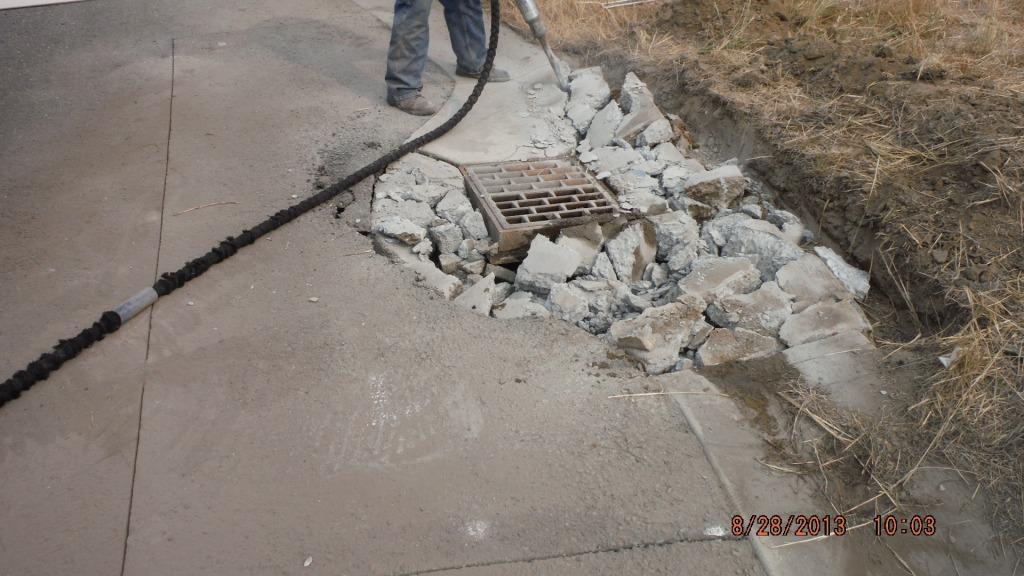
36 The Ridges While inves>ga>ng eroded patches in the pavement, it was found that this problem was caused by improper sealing of the catch basins to the surrounding concrete curb. While only one curb was in need of replacement, all of the catch basins in the next few slides were in need of repair from the inside to stop the problem from progressing.

37 Cobblestone Way
38 Cobblestone Way

39 Cobblestone Way

40 Cobblestone Way

41 Cobblestone Way

42 Cobblestone Way
43 Touchstone Ln.

44 End of 3 rd Ave.

45 Rock Ridge Way

46 Deer Pointe Dr.
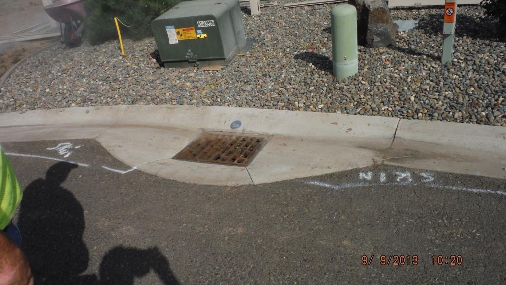
47 Florence & Rolling Hills The pipe to this drywell at the intersec>on was not properly grouted and sealed into the drywell. As a result, the underlying base rock around the structure and under the pavement, was eroded away. The problem was repaired by cu_ng out a pavement patch and cemen>ng the pipe into the structure. Gap

48 Florence and Rolling Hills


49 Florence and Rolling Hills

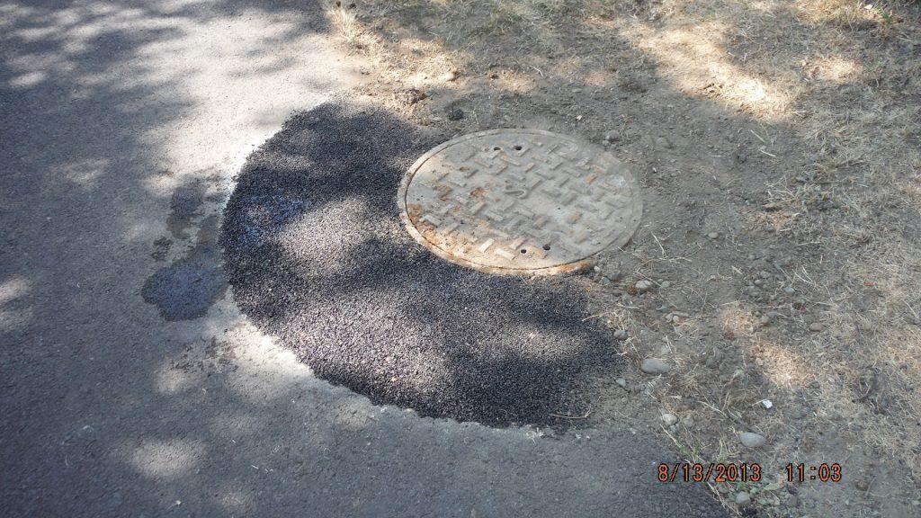
50 Greenbelt Trail This storm manhole had been paved over and was crea>ng a trip hazard on the walking path due to the pavement sepling. In addi>on it is impossible to inspect this structure in this condi>on. A simple addi>on of risers and repaving around the structure took care of the problem.


51 Greenbelt Trail

52 Some>mes our job can be hazardous!!!

53 Greenbelt Trail

54 County Yard Last but not least is the first phase of the County Wash Sta>on that was assigned to the Stormwater crew. The following slides are installa>on of the slot drain that will be hooked into the oil water separator upon it s comple>on.


55 County Yard


56 County Yard
57 Thank you for the opportunity to serve you!
Materials. Use materials meeting the following.
 208.01 Section 208. SOIL EROSION AND SEDIMENTATION CONTROL 208.01 Description. Install and maintain erosion and sedimentation controls to minimize soil erosion and to control sedimentation from affecting
Rock & Aggregate Drop Inlet Protection
 Rock & Aggregate Drop Inlet Protection SEDIMENT CONTROL TECHNIQUE Type 1 System Sheet Flow Sandy Soils Type 2 System [1] Concentrated Flow Clayey Soils Type 3 System Supplementary Trap Dispersive Soils
Construction Exits Rock pads
 Construction Exits Rock pads SEDIMENT CONTROL TECHNIQUE Type 1 System Sheet Flow Sandy Soils Type 2 System Concentrated Flow [1] Clayey Soils Type 3 System Supplementary Trap Dispersive Soils [1] Minor
Continuing Education Associated with Maintaining CPESC and CESSWI Certification
 Continuing Education Associated with Maintaining CPESC and CESSWI Certification Module 2: Stormwater Management Principles for Earth Disturbing Activities Sponsors: ODOTs Local Technical Assistance Program
Selected Site BMPs: Why s the Water Muddy? John C. Hayes, Ph.D., P. E. Biosystems Engineering Clemson University
 Selected Site BMPs: Why s the Water Muddy? John C. Hayes, Ph.D., P. E. Biosystems Engineering Clemson University The BMP worked fine until last week when it rained! Turbidity Best Management Practices
C11 EDR - STRONGHOLD BUILDING STORM WATER QUALITY MANAGEMENT PLAN ROBSTOWN, TEXAS, COUNTY ROAD 69 MUNOZ ENGINEERING CIVIL STRUCTURAL MARINE
 RMIII 6/3/7 U I U I TENTION POND REV ISSUED FOR CONSTRUCTION PHONE: 36-946-4848 38 ANDREA LN CORPUS CHRISTI, TX, 7844 TBPE FIRM No. F-4 TENTION DITCH LEGEND PROPOSED STORMWATER / DRAINAGE FLOW DIRECTION
Sediment Trap. A temporary runoff containment area, which promotes sedimentation prior to discharge of the runoff through a stabilized spillway.
 Sediment Trap SC-15 Source: Caltrans Construction Site Best Management Practices Manual, 2003. Description A temporary runoff containment area, which promotes sedimentation prior to discharge of the runoff
CONSTRUCTION EXIT SEDIMENT BARRIER
 241428_itizen ield Guide_v3 2/22/06 11:09 M Page 1 (1,1) ONSTRUTION EXIT stone pad located where traffic leaves a construction site to eliminate the transport of soil to public streets. SEDIMENT BRRIER
This report was prepared by Klohn Crippen Consultants Ltd. for Alberta Transportation Central Region under Contract No. CE053/2000.
 Alberta Transportation Central Region #401, 4902 51 Street Red Deer, Alberta T4N 6K8 June 7, 2002 Mr. Melvin Mayfield, P.Eng. Project Engineer Dear Mr. Mayfield: Central Region Landslide Assessment Site
APPENDIX B WORKSHEETS & EXHIBITS
 APPENDIX B WORKSHEETS & EXHIBITS A worksheet provides the designer a representation of a measure that allows for input of specific design criteria. The plan designer will be required to assess field conditions
PRELIMINARY ENGINEERING REPORT FOR SANITARY SEWER COLLECTION SYSTEM OSKALOOSA, IOWA 2017
 PRELIMINARY ENGINEERING REPORT FOR SANITARY SEWER COLLECTION SYSTEM OSKALOOSA, IOWA 2017 PRELIMINARY ENGINEERING REPORT FOR SANITARY SEWER COLLECTION SYSTEM OSKALOOSA, IOWA 2017 I hereby certify that this
Stone Outlet Sediment Trap
 3.12 Sediment Control Description: A stone outlet sediment trap is a small detention area formed by placing a stone embankment with an integral stone filter outlet across a drainage swale for the purpose
**Temporary Erosion Control**
 Construction operations And methods **Temporary Erosion Control** The test will more than likely just have a basic word problem dealing with Erosion control, if it has anything on the test. So just review,
Stormwater Inlet Sediment Traps
 Stormwater Inlet Sediment Traps SEDIMENT CONTROL TECHNIQUES Photo 1 Kerb inlet Photo 2 Field (drop) inlet Table 1 provides the recommended default classification of various sediment control systems suitable
City of Madison Flooding Event AUGUST 20 TH, 2018-PRESENT
 City of Madison Flooding Event AUGUST 20 TH, 2018-PRESENT Presentation Overview Review of Flash Flooding and Flooding from High Lake Levels (August 20 th -Present) Lake Level Information Damages FEMA How
STREUVER FIDELCO CAPPELLI, LLC YONKERS DOWNTOWN DEVELOPMENT PHASE 1. DRAFT ENVIRONMENTAL IMPACT STATEMENT For: PALISADES POINT
 STREUVER FIDELCO CAPPELLI, LLC YONKERS DOWNTOWN DEVELOPMENT PHASE 1 DRAFT ENVIRONMENTAL IMPACT STATEMENT For: PALISADES POINT Prepared by: PAULUS, SOKOLOWSKI & SARTOR STORMWATER MANAGEMENT 1. Methodology
Franklin County Engineer's Office - Highway Design Dublin Road And Fishinger Road Improvements Rebid Bid Tabulation
 2/20/2015 Page 1 of 16 Strawser Paving Co., Inc. Double Z Construction Co Decker Construction Company Shelly & Sands, Inc. 1595 Frank Road 2550 Harrison Road 3040 McKinley Avenue P.O.Box 2469 Columbus,
WATER MANAGEMENT REPORT FOR PAGE ESTATES
 WATER MANAGEMENT REPORT FOR PAGE ESTATES SLB Consulting of SW Florida, LLC PO Box 2826 Bonita Springs, FL. 34133 Phone: 239-948-9566 sandra@slbconsult.com C.O.A. # 25395 September 1, 2014 Sandra L. Bottcher
UNFINISHED BUSINESS 1. Issue 1 Funding No update.
 STREETS COMMITTEE MINUTES APRIL 4, 2017 The Streets Committee meeting was held on April 4, 2017 at North Royalton City Hall, 14600 State Road. The meeting was called to order at 6:21 p.m. PRESENT: Committee
Construction Exits Vibration grids
 Construction Exits Vibration grids SEDIMENT CONTROL TECHNIQUE Type 1 System Sheet Flow Sandy Soils Type 2 System Concentrated Flow Clayey Soils [1] Type 3 System Supplementary Trap Dispersive Soils [1]
B805 TEMPORARY EROSION AND SEDIMENT CONTROL MEASURES - OPSS 805
 B805 MEASURES - OPSS 805 805.1 GENERAL Construction activities frequently remove protective cover and expose soil to accelerated rates of erosion. Sediments generated thereby can be conveyed via runoff
SILT FENCE EFFECTIVENESS
 SILT FENCE EFFECTIVENESS Michelle G. Holloway, Department of Earth Sciences, University of South Alabama, Mobile, AL 36688. E-mail: MLG@jaguar1.usouthal.edu. Sediment is the number one pollutant in Dog
A HYDROLOGIC STUDY OF THE EFFECTS OF URBAN DEVELOPMENT ON STORM RUNOFF: A CASE STUDY IN QUEENS, NY ABSTRACT
 154 A HYDROLOGC STUDY OF THE EFFECTS OF URBAN DEVELOPMENT ON STORM RUNOFF: A CASE STUDY N QUEENS, NY Monica Tsang-Rakovan, Kevin J. Phillips, Khalid Bajwa, John Ferrelli, Fanning, Phillips and Molnar Fanning,
1. PROJECT BACKGROUND. July 18, Alberta Infrastructure & Transportation Central Region #401, Street Red Deer, Alberta T4N 6K8
 July 18, 2005 Alberta Infrastructure & Transportation Central Region #401, 4902 51 Street Red Deer, Alberta T4N 6K8 Mr. Alain Momedi, P.Eng. Project Engineer Dear Mr. Momedi: H11:04 km 11.1 Erosion along
Sediment Trap. At multiple locations within the project site where sediment control is needed.
 Sediment Trap SE-3 Objectives EC Erosion Control SE Sediment Control TR Tracking Control WE Wind Erosion Control Non-Stormwater NS Management Control Waste Management and WM Materials Pollution Control
TOWN OF BASALT SNOW MANAGEMENT PLAN
 TOWN OF BASALT SNOW MANAGEMENT PLAN Introduction Snow management in the Town of Basalt is the responsibility of the Department of Public Works. The overall goal is the restoration of clear, passable pavement
D. B. G R A Y E N G I N E E R I N G I N C.
 STORMWATER MANAGEMENT REPORT 948 Hunt lub Road Ottawa, Ontario Report No. 12020-SWM August 27, 2012 Revised April 21, 2014 Revised December 9, 2014 Revised April 14, 2015 D. B. G R A Y E N G I N E E R
Field Trip Number One. By: Pat Dryer. Geography 360
 Field Trip Number One By: Pat Dryer Geography 360 Table of Contents Introduction. Page 1 Stop One... Page 2 Stop Two... Page 4 Stop Three... Page 5 Stop Four... Page 7 Bibliography Page 8 Campus Map Source:
TPDES: Soil, Erosion and Sedimentation Methods
 SAWS TPDES: Soil, Erosion and Sedimentation Methods Philip Handley Supervisor-Resource Protection & Compliance August 25, 2014 TPDES: Soil, Erosion and Sedimentation Methods Soil Common term: Dirt Common
APPENDIX B DESIGN CRITERIA FOR TEMPORARY WATER QUALITY BMPS USED DURING CONSTRUCTION
 APPENDIX B DESIGN CRITERIA FOR TEMPORARY WATER QUALITY BMPS USED DURING CONSTRUCTION This Appendix presents design criteria and example calculations for the following temporary water quality BMPs for use
Homeowner s Mitigation Projects Spared Home from Mudflow Damage
 Homeowner s Mitigation Projects Spared Home from Mudflow Damage Full Mitigation Best Practice Story Los Angeles County, California Los Angeles County, CA - In the summer and fall of 2009, Southern California
Hydrology Study Report
 Hafeez Consulting www.hafeezconsulting.com Civil/ Structural Engineering, Design & Construction 1451 S. Hacienda St. Anaheim CA 92804 (714) 225-4565 Fax (714)917-2977 engineer@hafeezconsulting.com Hydrology
APPENDIX E GREATER SPRINGFIELD RELIABILTIY PROJECT DRAINAGE ANALYSIS FOR THE NEWGATE/PHELPS ROAD AND THE HATCHETT HILL ROAD AREAS
 APPENDIX E GREATER SPRINGFIELD RELIABILTIY PROJECT DRAINAGE ANALYSIS FOR THE NEWGATE/PHELPS ROAD AND THE HATCHETT HILL ROAD AREAS New England East-West Solution (NEEWS) Greater Springfield Reliability
Crows Landing Naval Base Easement
 1 of 15 West Stanislaus Resource Conservation District Crows Landing Naval Base Easement Annual Reserve Monitoring Report Jamie McFarlin 11/112012 2 of 15 West Stanislaus Resource Conservation District
Template for Sediment and Erosion Control Plan General Instructions. Section Instructions
 Template for Sediment and Erosion Control Plan General Instructions Introduction: Soil erosion and sediment deposition from farmlands can contribute to degraded surface water quality. Sediment delivery
Suitable Applications Sediment traps should be considered for use:
 Categories EC Erosion Control SE Sediment Control TC Tracking Control WE Wind Erosion Control Non-Stormwater NS Management Control Waste Management and WM Materials Pollution Control Legend: Primary Objective
STORMWATER MANAGEMENT REPORT
 STORMWATER MANAGEMENT REPORT THE FAIRWAYS AT EDGEWOOD LOTS 5 & 6, BLOCK 1201 TOWNSHIP OF RIVER VALE BERGEN COUNTY, NEW JERSEY PREPARED BY: DAPHNE A. GALVIN PROFESSIONAL ENGINEER LICENSE NO. 24GE03434900
Stormwater Outlet Sediment Traps
 Stormwater Outlet Traps SEDIMENT CONTROL TECHNIQUES Photo 1 Excavated sediment trap just prior to scheduled clean-out (note energy dissipater at end of pipe) Photo 2 A supplementary straw bale barrier
BRANDON LAKES AVENUE PRE AND POST CONDITIONS DRAINAGE REPORT
 BRANDON LAKES AVENUE PRE AND POST CONDITIONS DRAINAGE REPORT Hillsborough County Public Works County Center, 22nd Floor 601 E. Kennedy Blvd. Tampa, FL 33602 BRANDON LAKES AVENUE DRAINAGE IMPROVEMENTS Capital
Severe Storm Response Version # 1-0-1
 Severe Storm Response Version # 1-0-1 Weather Warnings Environment Canada issues severe weather warnings, watches and advisories Weather Watch Severe weather may develop. Weather Warning Severe weather
SHORT NIGHTTIME WATER SHUTDOWN TO OCCUR IN EARLY HOURS OF MAY 29
 Thank you for your interest in the Center City Connector Streetcar. In this weekly update, you ll find information about ongoing construction for the 1st phase of utility work in Pioneer Square. UPDATES
TCHARTIERS TOWNSHIP BOARD OF SUPERVISORS SPECIAL MEETING March 11, :30 p.m. Allison Hollow Road Reconstruction Project
 TCHARTIERS TOWNSHIP BOARD OF SUPERVISORS SPECIAL MEETING March 11, 2014 5:30 p.m. Allison Hollow Road Reconstruction Project A. William Kiehl called the Special Meeting of Tuesday March 11, 2014, at 5:30
Black Gore Creek 2013 Sediment Source Monitoring and TMDL Sediment Budget
 Black Gore Creek 2013 Sediment Source Monitoring and TMDL Sediment Budget Prepared for: Prepared By: - I. Introduction The Black Gore Creek Total Maximum Daily Load (TMDL) was developed in collaboration
Coarse Sediment Traps
 Coarse Sediment Traps SEDIMENT CONTROL TECHNIQUE Type 1 System Sheet Flow Sandy Soils Type 2 System [1] Concentrated Flow Clayey Soils [2] Type 3 System Supplementary Trap Dispersive Soils [1] Though primarily
FOR PROJECTS INITIATED AFTER NOVEMBER 1, 2008 ITEM 716 EMBANKMENT EARTH OUTLET SEDIMENT TRAP
 AFTER NOVEMBER 1, 2008 ITEM 716 EMBANKMENT EARTH OUTLET SEDIMENT TRAP 716.1 Description. This work shall consist of furnishing, installing, maintaining, and removing temporary erosion protection and sediment
Rucker Pond. Background
 Rucker Pond Background The Rucker Basin consists of two subbasins (East and West) that drain to a single area known as Rucker Pond. Both subbasins have the same hydraulic parameters, but have different
Observations on Surface Water in the Seminary Fen in Spring, Prepared 6/4/13 by Sam Wetterlin; updated 7/28/13
 Observations on Surface Water in the Seminary Fen in Spring, 2013 Prepared 6/4/13 by Sam Wetterlin; updated 7/28/13 Ordinarily, a calcareous fen is primarily dependent on upwelling mineral-rich, oxygen-poor
Public Inspection and Maintenance Checklist Sand Filters (Above Ground/Open)
") Public Inspection and Checklist Sand Filters (Above Ground/Open) Sediment Accumulation on top layer* Trash and Debris Sediment/ Debris in Clean-Outs* Sand Filter Media* Prolonged Flows Short Circuiting
Public Inspection and Checklist Sand Filters (Above Ground/Open) Sediment Accumulation on top layer* Trash and Debris Sediment/ Debris in Clean-Outs* Sand Filter Media* Prolonged Flows Short Circuiting
January 17, 2008 File:
 January 17, 2008 File: 15-85-73 Alberta Infrastructure and Transportation Room 301, Provincial Building 9621-96 Avenue Peace River, Alberta T8S 1T4 Attention: Mr. Ed Szmata PEACE REGION (SWAN HILLS AREA)
Winning Farm of Winchester
 Winning Farm of Winchester Planning Board Presentation Winning Farm of Winchester 12.9 acres of undeveloped forest on the former Winning Farm site Located north of Thornberry Road in the northwestern corner
1 PROJECT BACKGROUND. August 14, Alberta Transportation Central Region #401, Street Red Deer, Alberta T4N 6K8
 August 14, 2013 Alberta Transportation Central Region #401, 4902 51 Street Red Deer, Alberta T4N 6K8 Mr. Dennis Grace, P.Eng. Construction Engineer Dear Mr. Grace: Central Region Geohazard Assessment 2013
CITY OF CAPE CORAL STORMWATER MASTER PLAN PHASE II - PART 1 BASINS 4, 10, & 14 SUB-BASIN DRAINAGE IMPROVEMENTS HYDRAULIC ANALYSIS SUMMARY
 CITY OF CAPE CORAL STORMWATER MASTER PLAN PHASE II - PART 1 BASINS 4, 10, & 14 SUB-BASIN DRAINAGE IMPROVEMENTS HYDRAULIC ANALYSIS SUMMARY Cape Coral, FL Prepared for: The City of Cape Coral Public Works
3/8/17. #20 - Landslides: Mitigation and Case Histories. Questions for Thought. Questions for Thought
 #20 - Landslides: Mitigation and Case Histories Web Exercise #3 (Volcanoes) Due Wednesday There is a 2-point penalty for every day the assignment is late. Exam 1 Scores Scores and exam key are posted Vaiont
U-Shaped Sediment Traps
 U-Shaped Sediment Traps SEDIMENT CONTROL TECHNIQUE Type 1 System Sheet Flow Sandy Soils Type 2 System Concentrated Flow Clayey Soils [1] Type 3 System Supplementary Trap Dispersive Soils [1] Generally
February 18, 2003 File: NORTH CENTRAL REGION LANDSLIDE ASSESSMENT HWY 43:16 WHITECOURT EAST HILL (NC1) 2002 ANNUAL INSPECTION REPORT
 2002 ANNUAL INSPECTION REPORT") February 18, 2003 File: 15-76-11 Alberta Transportation Room 223, Provincial Building 4709 44 Avenue Stony Plain, Alberta T7Z 1N4 Attention: Mr. Rob Lonson, P.Eng. NORTH CENTRAL REGION LANDSLIDE ASSESSMENT
February 18, 2003 File: 15-76-11 Alberta Transportation Room 223, Provincial Building 4709 44 Avenue Stony Plain, Alberta T7Z 1N4 Attention: Mr. Rob Lonson, P.Eng. NORTH CENTRAL REGION LANDSLIDE ASSESSMENT
Template for Sediment and Erosion Control Plan General Instructions
 Template for Sediment and Erosion Control Plan General Instructions Introduction: Soil erosion and sediment deposition from farmlands can contribute to degraded surface water quality. Sediment delivery
Agenda. INDOT Office of Environmental Services. Describe Results of FHWA QAR. Landscape and Waterway Permitting Unit. Interviews Site Inspections
 Nathan Saxe Administrator, Ecology and Waterway Permitting Section Back to Basics: Erosion and Sediment Control FHWA INDOT Quality Assurance Review (QAR) Results 1 Agenda INDOT Office of Environmental
August 10, 2007 File:
 August 10, 2007 File: 15-85-72 Alberta Infrastructure and Transportation Room 301, Provincial Building 9621-96 Avenue Peace River, AB T8S 1T4 Attention: Mr. Ed Szmata PEACE REGION (PEACE HIGH LEVEL AREA)
HISTORY OF CONSTRUCTION FOR EXISTING CCR SURFACE IMPOUNDMENT PLANT GASTON ASH POND 40 CFR (c)(1)(i) (xii)
(1)(i) (xii)") HISTORY OF CONSTRUCTION FOR EXISTING CCR SURFACE IMPOUNDMENT PLANT GASTON ASH POND 40 CFR 257.73(c)(1)(i) (xii) (i) Site Name and Ownership Information: Site Name: E.C. Gaston Steam Plant Site Location:
HISTORY OF CONSTRUCTION FOR EXISTING CCR SURFACE IMPOUNDMENT PLANT GASTON ASH POND 40 CFR 257.73(c)(1)(i) (xii) (i) Site Name and Ownership Information: Site Name: E.C. Gaston Steam Plant Site Location:
CCR Rule Annual Inspection Report (cont.) 2
 2") The inspection findings consisted of maintenance items and items that were not observed to be signs or potential signs of significant structural weakness. No deficiencies or disrupting conditions that
The inspection findings consisted of maintenance items and items that were not observed to be signs or potential signs of significant structural weakness. No deficiencies or disrupting conditions that
Sediment Control Log (SCL)
") Description A sediment control log is a linear roll made of natural materials such as straw, coconut fiber, or other fibrous material trenched into the ground and held with a wooden stake. Sediment control
Description A sediment control log is a linear roll made of natural materials such as straw, coconut fiber, or other fibrous material trenched into the ground and held with a wooden stake. Sediment control
Taft Stormwater Quest
 Taft Stormwater Quest Oregon Coast Quests is an Oregon Sea Grant program based at Oregon State University's Hatfield Marine Science Center. The Oregon Coast Book, 2017 18 Edition 43 Use this map to help
FIG. A1 TODDY THOMAS SCHOOL - NORTH SAFE ROUTES TO SCHOOL CONCEPTUAL LAYOUT CITY OF FORTUNA TODDY THOMAS SCHOOL - NORTH GENERAL NOTES KEYNOTES
 GENERAL NOTES. NEW & RELOCATED ROADWAY SIGNS NOT SHOWN FOR CLARITY BUT, ARE INCLUDING IN CONCEPTUAL DESIGN COST ESTIMATE. KEYNOTES E X I S T I N G D E V E L O P M E N T. NEW 5' WIDE CONCRETE SIDEWALK.
MONTGOMERY COUNTY SNOW PLAN
 2018 2019 MONTGOMERY COUNTY SNOW PLAN COMMUNICATION DURING SNOW/ICE SITUATIONS Communication will be established prior/during all winter storms between the Sheriff s Office, Public Works Department, and
Investigating Factors that Affect Erosion
 Investigating Factors that Affect Erosion On your erosion walk and while you were reading the cases, you may have noticed that the type of soil or other Earth materials can make a difference in how and
Presented at the 78 th Annual Water Environment Federation Technical Exposition and Conference. Washington, D.C. Oct. 29 Nov. 2, 2005.
 Presented at the 78 th Annual Water Environment Federation Technical Exposition and Conference. Washington, D.C. Oct. 29 Nov. 2, 2005. IMPERVIOUS SURFACES IN URBAN WATERSHEDS Celina Bochis-Micu and Robert
Climate Adaptation Challenges for Boston s Water and Sewer Systems
 National Association of Flood & Stormwater Management Agencies Climate Adaptation Challenges for Boston s Water and Sewer Systems John P Sullivan P.E. October 15,2014 Boston 1630 Boston 1630-2012 Boston
Science in the Schoolyard Guide: FOSS California Solid Earth
 Soild Earth Solid Earth > Investigation 5: Landforms > Part 2: Erosion, page 190 and Part 3: Deposition, page 199 Erosion and Deposition Parts 2 and 3 may be conducted outdoors. Refer to page 190 (Part
Track design and management
 1 Track design and management Peter Fogarty, Certified Professional Soil Scientist NSW Soil Knowledge Network Cooma, June 18, 2018 Acknowledgements Antia Brademann, Cooma Waterwatch, Organiser Jo Powells,
Trainee Manual C02 CITY OF SASKATOON. Water and Sewer Section. Severe Storm Response Trainee Manual. Version # 1-0-3
 Trainee Manual C02 CITY OF SASKATOON Water and Sewer Section Severe Storm Response Trainee Manual CITY OF SASKATOON Severe Storm Response Trainee Manual City of Saskatoon Severe Storm Response Trainees
Black Gore Creek Total Maximum Daily Load Sediment Source Monitoring 2008 Vail Pass, Colorado. Prepared for: Eagle River Watershed Council
 Black Gore Creek Total Maximum Daily Load Sediment Source Monitoring 2008 Vail Pass, Colorado Prepared for: Eagle River Watershed Council Prepared by: RiverRestoration.org I. Introduction This document
EVALUATION OF SLOPE STABILITY NEAR LOTS #3-6, LOWER ICEHOUSE CANYON ROAD, MT. BALDY, CALIFORNIA
 EVALUATION OF SLOPE STABILITY NEAR LOTS #3-6, LOWER ICEHOUSE CANYON ROAD, MT. BALDY, CALIFORNIA by Dr. Jonathan A. Nourse, Associate Professor Department of Geological Sciences California State Polytechnic
Tsukuba, Japan International Institute of Seismology and Earthquake Engineering Building Research Institute STUDY TRIP TO ITAKO CITY
 Tsukuba, Japan International Institute of Seismology and Earthquake Engineering Building Research Institute STUDY TRIP TO ITAKO CITY A Technical Report By MARTINEZ BRAVO Delvin Abdiel (MEE10515) Disaster
MIDDLESEX COUNTY Department of Planning and Community Development P.O. Box 427, Saluda, VA Phone: Fax:
 MIDDLESEX COUNTY Department of Planning and Community Development P.O. Box 427, Saluda, VA 23149 Phone: 804-758-3382 Fax: 804-758-0061 LAND DISTURBANCE PERMIT SUBMISSION REQUIREMENTS In order to expedite
Landslide Mitigation (BYUI)
") Landslide Mitigation (BYUI) The general principle behind landslide mitigation is stabilization. Slopes that are too steep are shallowed or strengthened. Loose rocks can be bolted or cemented into place.
Landslide Mitigation (BYUI) The general principle behind landslide mitigation is stabilization. Slopes that are too steep are shallowed or strengthened. Loose rocks can be bolted or cemented into place.
Geology Chapter Teacher Sheet. Activity #3: Determining the Percolation Rate of Soil
 Geology Chapter Teacher Sheet Activity #3: Determining the Percolation Rate of Soil Adapted from The Percolation Rate of a Soil, CurriculumResources for Earth Science Teachers, Maine Department of Conservation.
Exhibit "A" Date: 1/27/2011
 Exhibit "A" Date: 1/27/2011 To: Bentley Communities Contact: Doug Knox Address: 1595 Paoli Pike Phone: 610-430-3700 West Chester, PA 19380 Fax: 610-430-3228 Project Name: Culbertson Village (Eastern Quadrent)(Phase
Whether you are driving or walking, if you come to a flooded road, Turn Around Don't Drown
 Whether you are driving or walking, if you come to a flooded road, Turn Around Don't Drown You will not know the depth of the water nor will you know the condition of the road under the water. Many people
New Jersey Department of Transportation DATE : 04/10/12 PAGE : TABULATION OF BIDS
 PAGE : 421-1 CONTRACT TIME : 12/15/12 COMPLETION DATE CONTRACT DESCRIPTION : PROJECT(S) : 100% STATE MAINTENANCE ROADWAY REPAIR CONTRACT CENTRAL, CONTRACT NO. C204, DP 11421 ROUTES US 1 NB & SB, 18 NB
Which map shows the stream drainage pattern that most likely formed on the surface of this volcano? A) B)
 B)") 1. When snow cover on the land melts, the water will most likely become surface runoff if the land surface is A) frozen B) porous C) grass covered D) unconsolidated gravel Base your answers to questions
1. When snow cover on the land melts, the water will most likely become surface runoff if the land surface is A) frozen B) porous C) grass covered D) unconsolidated gravel Base your answers to questions
Controlling Processes That Change Land
 1 Name Date Controlling Processes That Change Land People try to control some of the processes that change land. To do this, people apply technology- the use of science to solve problems in everyday life.
Background. Valley fills Sites in the Area. Construction over Mine Spoil Fills
 Construction over Mine Spoil Fills Wayne A. Karem, PhD, PE, PG, D.GE 2014 KSPE Annual Conference Background Strip mining; mountaintop and contour mining Creates huge quantities of mine spoil The mine spoil
Standards for Soil Erosion and Sediment Control in New Jersey May 2012
 STANDARD FOR SEDIMENT BASIN Definition A barrier, dam, excavated pit, or dugout constructed across a waterway or at other suitable locations to intercept and retain sediment. Basins created by construction
October 26, Ms. Aimee Zack Canadian Pacific 120 S. Sixth Street Suite 900 Minneapolis, Minnesota 55402
 October 26, 2017 Ms. Aimee Zack Canadian Pacific 120 S. Sixth Street Suite 900 Minneapolis, Minnesota 55402 Re: Soo Line Dump Site 2017 Annual Soil Cover Inspection Dear Aimee: The purpose of this letter
11/21/2014. Erosion and Sedimentation Control Planning and Design Workshop December 2, 2014
 Erosion and Sedimentation Control Planning and Design Workshop December 2, 2014 1 A STATE PRIMARILY OF A SUBTROPICAL CLIMATE WEATHER PATTERNS COME PREDOMINATELY FROM THE WEST APPALACHIAN MTNS SHIELDS IT
Sediment Control Practices. John Mathews Ohio Dept. of Natural Resources, Division of Soil and Water Resources
 Sediment Control Practices John Mathews Ohio Dept. of Natural Resources, Division of Soil and Water Resources Practices Treat the Largest Soil Particles Sand Sand Silt Clay Treated Untreated Settleable
 DRAFT DRAFT DRAFT DRAFT DRAFT SEDIMENT CONTROLS Method Application Description BMP Sediment fencing Flat Ground Y Anywhere low flow runoff is Sloping Ground Y Geotextile fabric, buried at the bottom
CITY OF PERRIS FLOOD CONTROL MAINTENANCE DISTRICT NO. 1. ANNUAL ENGINEER S REPORT FISCAL YEAR 2011/2012 April 26, 2011
 CITY OF PERRIS FLOOD CONTROL MAINTENANCE DISTRICT NO. 1 ANNUAL ENGINEER S REPORT FISCAL YEAR 2011/2012 April 26, 2011 AGENCY: City of Perris PROJECT: Flood Control Maintenance District No. 1 TO: City Council
1 City of Edmonton Quesnell Bridge, Roads and Associated Structures Assessment
 1 City of Edmonton Quesnell Bridge, Roads and Associated Structures Assessment 1.1 Background Within the First National Engineering Vulnerability Assessment, the Public Infrastructure Engineering Vulnerability
WELCOME Lake Wabukayne OPEN HOUSE
 WELCOME Lake Wabukayne Sediment Removal Project OPEN HOUSE We are here to: Update you, the community, on recent developments and activities at Lake Wabukayne Present the preferred alternative and receive
POLICY MANUAL. Hamlets/Residential named hamlets within the County of Grande Prairie whose roads are hard surfaced.
 POLICY MANUAL Legal References: Policy department: Public Works Department Cross References: N7 Adoption Date: January 19, 2005 Revision Date: June 20, 2005 Motion# 06/662/2005 October 20, 2014 Motion#
Team Canada Winter Maintenance Practices in Southern Ontario
 Team Canada Winter Maintenance Practices in Southern Ontario APWA International Congress & Exposition Toronto, Ontario Tuesday, August 19, 2014 Introductions Dominic Guthrie, Senior Coordinator, Emergency
A regular meeting of the Village of Victor Planning Board was held on Wednesday, July 26, 2017, at the Village Hall, 60 East Main Street.
 A regular meeting of the Village of Victor Planning Board was held on Wednesday, July 26, 2017, at the Village Hall, 60 East Main Street. MEMBERS PRESENT: Chairperson Meg CHaides Vice Chairperson Peter
COLORING PAGES. Follow Raindy the Raindrop as he travels from your house out to sea.
 COLORING PAGES www.hcfcd.org Follow Raindy the Raindrop as he travels from your house out to sea. Raindy the Raindrop falls from the sky and lands on your house or in your neighborhood. Once he s on the
CITY OF PERRIS FLOOD CONTROL MAINTENANCE DISTRICT NO. 1. ANNUAL ENGINEER S REPORT FISCAL YEAR 2015/2016 May 12, 2015
 CITY OF PERRIS FLOOD CONTROL MAINTENANCE DISTRICT NO. 1 ANNUAL ENGINEER S REPORT FISCAL YEAR 2015/2016 May 12, 2015 AGENCY: City of Perris PROJECT: Flood Control Maintenance District No. 1 TO: City Council
Case Study 14. Rocky Creek Vented Box Culvert Ford
 Case Study. Rocky Creek Vented Box Culvert Ford Location West Central Arkansas. Ouachita National Forest; Oden Ranger District. Rocky Creek crossing on Forest Road 887 (Muddy Gibbs Road). Crossing Description
CUSTER COUNTY SNOW REMOVAL PROCEDURES
 CUSER COUNY SNOW REMOVAL PROCEDURES Prioritization of Plow Routes County-maintained roads are plowed based upon the following prioritization criteria: 1. Arterial Roadways and School Bus routes: Arterial
ROAD DISTRICT RESIDENT HANDBOOK
 ROAD DISTRICT RESIDENT HANDBOOK REV. 2 12-11-15 A Message From the Road District Dear Resident: The Wheatland Township Road District is pleased to provide this resident handbook. The handbook addresses
WEST NORRITON TOWNSHIP
 WEST NORRITON TOWNSHIP SANITARY SEWER SYSTEM INFLOW AND INFILTRATION STUDY November 2013 Rettew Associates, Inc. 3020 Columbia Avenue Lancaster, PA 17603 RECOMMENDATIONS The top four priorities for inflow
TRAFFIC ALERT FOR WEEK OF February 4 8, 2008
 TRAFFIC ALERT FOR WEEK OF February 4 8, 2008 Highway work zones in the Staunton District The following is a list of highway work that might affect traffic in the Staunton transportation district during