CW3E Atmospheric River Outlook
|
|
|
- Lesley Howard
- 6 years ago
- Views:
Transcription

1 CW3E Atmospheric River Outlook Update on Atmospheric River Forecast to Impact California This Week - Precipitation continues to fall across portions of California - The AR will begin to propagate southward bringing moderate AR conditions to Orange and San Diego Counties - As much as 9.5 inches of precipitation has fallen over the Coastal Mountains of California during the last 48 hours - ~3.75 inches of precipitation has fallen over the high elevations of Santa Barbara and Ventura Counties and 3.5 more inches could fall during the remainder of the storm - AR conditions are expected to end at ~11 pm PDT (+/ 3 hours) tonight over Southern California

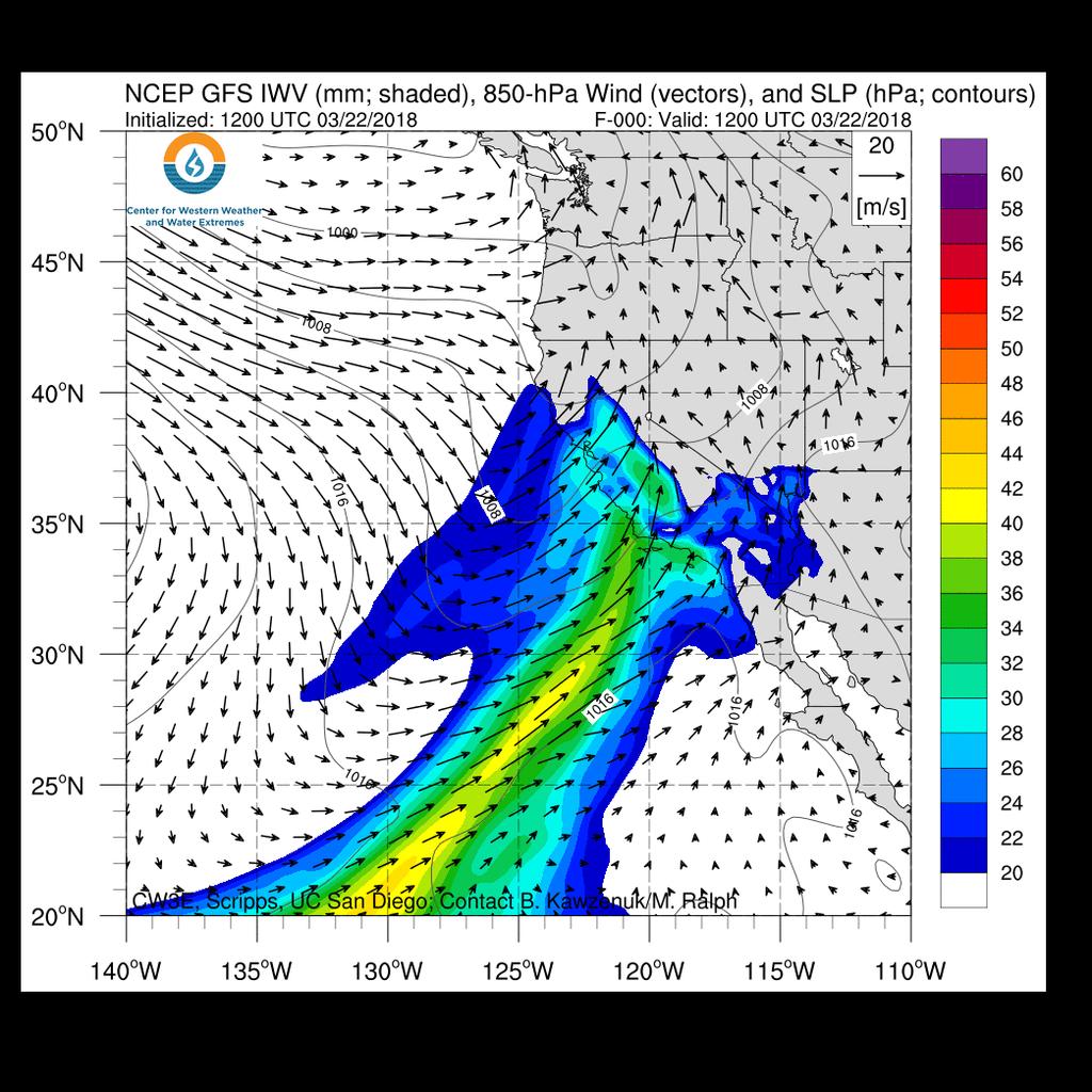
2

3 For California DWR s AR Program San Diego County is forecast to experience Moderate AR conditions for ~6 9 hours between 11 AM PDT and 6 PM PDT Today Extreme AR conditions are expected to end around 11 PM tonight Magnitude of Potential AR Maximum predicted IVT ~675 kg m 1 s 1 Mean IVT ~625 kg m 1 s 1 Minimum IVT ~500 kg m 1 s 1 San Diego County Strong Mod. Weak Not AR


4 72-hr QPE ending 11:35 PM PDT 22 March Raw Data not QC d As much as inches of precipitation has fallen over the high elevations of the Coastal and Sierra Nevada Mountains over the past 72 hours ~ inches of precipitation has fallen over the higher elevations in Santa Barbara and Ventura Counties An additional 3.25 inches could fall over the Santa Ynez Mountains while as much as 4.5 could fall over the higher elevations of the Sierra Nevada Mountains 72-hr QPF ending 5 AM PDT 25 March Raw Data not QC d For official CNRFC Products: cnrfc.noaa.gov


5 There are currently 2 rivers forecast by the CNRFC to rise above flood stage with an additional 9 forecast to rise above monitor stage There are currently no Rivers or streams in Southern California forecast to rise above monitor CNRFC 6-day River Stage Forecast For official California-Nevada Forecast Center Products: cnrfc.noaa.gov The Middle Fork of the Feather River in Portola is currently forecast to rise to 9.1 feet at 6 AM 24 March,.6 feet above flood stage

6 Initial/Preliminary Impacts Officials ordered mandatory evacuations in Santa Barbara, Ventura, and Los Angeles counties on Wednesday due to potential debris flows, mud slides, and flash flooding on burn scar Falling rocks and mud sliders were reported along two highways in the foothills of Fresno County State route 33 is closed north of Ojai, CA due to mud and debris on roadway Debris flow was reported by Ventura Fire Department along Aliso Street in Ventura County EF-0 Tornado occurred in Yuba County on Wednesday Evening Urban flooding reported in Sacramento, Fresno, and Clovis, CA Reported Impacts from the NOAA Operations Center For localized forecasts and watches/warnings visit
 Valid 5 AM PDT 21 to 22 March 2018 The 24-hr")


7 CNRFC 24-hr QPF issued 20 March valid 5 AM PDT 21 to 5 AM 22 March 2018 CNRFC 24-hr QPE valid 5 AM PDT 21 to 5 AM 22 March 2018 CNRFC 24-hr Verification (QPF QPE) Valid 5 AM PDT 21 to 22 March 2018 The 24-hr accumulated precipitation forecast for the period ending at 5 am PDT 22 March had a maximum accumulation of ~5.25 inches over the Santa Ynez Mts. The 24-hr quantitative precipitation estimate (QPE) indicated that ~6 inches fell along the Coastal Mts. and ~2 inches fell over the Santa Ynez Mts. The QPE accumulations resulted in an over forecast of ~3 in. over the Santa Ynez Mts. and an under forecast of ~3 in. over Big Sur

8 2-day lead-time forecast Actual landfall position km error in AR landfall position: Big Sur vs Santa Barbara 48-hr AR Forecast Actual AR position Landfall position error The errors in the precipitation forecasts were partly driven by errors in weather model forecast of AR landfall location The forecast issued at 5 PM PT on Mon. 19 March predicted that the core of the AR 2 days later would be located just west of Santa Barbara at 5 PM PT Wed. 21 March, and would have produced up to 10 inches of rain in the mountains above Santa Barbara However, the observations (GFS analysis) showed that the core of the AR was instead over Big Sur (~ km from the predicted position). Big Sur did receive up to 9-10 inches of rain, while mountains above Santa Barbara 4-5 inches

9 For California DWR s AR Program Odds of at least a WEAK AR making landfall There is currently a low probability of AR landfall over CA in the next week once the current AR ends
CW3E Atmospheric River Outlook Update on Atmospheric River Forecast to Impact California This Week - Light to moderate precipitation has begun
 CW3E Atmospheric River Outlook Update on Atmospheric River Forecast to Impact California This Week - Light to moderate precipitation has begun falling over portions of California - GFS Ensemble members
CW3E Atmospheric River Outlook
 CW3E Atmospheric River Outlook Update on Atmospheric River Forecast to Impact California Next Week - The terminus of the atmospheric river plume is approaching coastal CA and precipitation will begin today
CW3E Atmospheric River Summary
 CW3E Atmospheric River Summary A strong AR made landfall over southern California this week - The atmospheric river made initial landfall over Big Sur around 1800 UTC Wednesday, 20 March 2018 - AR conditions
CW3E Atmospheric River Update
 CW3E Atmospheric River Update Update on ARs Currently Impacting and Forecast to Impact West Coast Precipitation continues to fall over a majority of California The Transverse Mountains (north of Santa
CW3E Atmospheric River Post Event Summary
 CW3E Atmospheric River Post Event Summary CW3E Atmospheric River Post Event Summary Strong AR recently made landfall over northern California - The AR reached its strongest magnitude of ~ 750 kg m -1 s
CW3E Atmospheric River Outlook
 CW3E Atmospheric River Outlook For California DWR s AR Program Update on the ARs forecast to Impact California this Week - Forecast confidence within the GEFS has continued to increase for the two ARs
CW3E Atmospheric River Outlook
 CW3E Atmospheric River Outlook For California DWR s AR Program Potential for Atmospheric River Activity over California Next Week - Multiple systems are currently forecasted to potentially bring AR conditions
CW3E Atmospheric River Update
 CW3E Atmospheric River Update Update on AR Currently Impacting CA, OR, and WA Precipitation continues to fall over portions of Northern California, Washington, and Oregon 6 10 inches of precipitation has
CW3E Atmospheric River Update Outlook
 Outlook provided by B. Kawzenuk, J. Kalansky, and F.M. Ralph; 12 PM PT Wednesday 7 March 2018 CW3E Atmospheric River Update Outlook Weak Atmospheric River expected to impact the U.S. West Coast this week
CW3E Atmospheric River Update and Outlook
 Summary by C. Hecht and F.M. Ralph 3 PM PT Thurs 19 Jan. 2017 CW3E Atmospheric River Update and Outlook Update on 3 ARs Forecast to Impact the West Coast Over Next Several Days - AR 1 made landfall over
CW3E Atmospheric River Update Outlook
 CW3E Atmospheric River Update Outlook Two systems expected to produce precipitation over the U.S. West Coast in the next week - AR conditions (IVT >250 kg m -1 s -1 and IWV >20 mm) are expected over most
CW3E Atmospheric River Outlook Update on the Multiple ARs forecast to Impact California this Week - Forecast confidence in the onset, duration, and
 CW3E Atmospheric River Outlook Update on the Multiple ARs forecast to Impact California this Week - Forecast confidence in the onset, duration, and magnitude of AR conditions has increased since the last
CW3E Atmospheric River Outlook
 CW3E Atmospheric River Outlook For California DWR s AR Program Multiple ARs Forecast to impact the USWC in the coming Week - A shift into an active flow pattern may result in the landfall of successive
CW3E Atmospheric River Update
 CW3E Atmospheric River Update Update on ARs Currently Impacting and Forecast to Impact West Coast As much as 6.5 inches of precipitation has fallen over the high elevations of CA over the previous 48 hours
CW3E Atmospheric River Update Outlook Strong AR forecast to impact California this weekend - A strong AR with IVT as high as 1000 kg m -1 s -1 is
 CW3E Atmospheric River Update Outlook Strong AR forecast to impact California this weekend - A strong AR with IVT as high as 1000 kg m -1 s -1 is forecast make landfall over the West Coast this Weekend
Outlook provided by B. Kawzenuk, J. Kalansky, and F.M. Ralph; 3 PM PT Wednesday 3 January 2018
 Outlook provided by B. Kawzenuk, J. Kalansky, and F.M. Ralph; 3 PM PT Wednesday 3 January 2018 CW3E Atmospheric River Update Outlook Two systems expected to produce precipitation over the U.S. West Coast
CW3E Atmospheric River Outlook
 CW3E Atmospheric River Outlook For California DWR s AR Program Update on the ARs Currently Impacting and Forecast to Impact the U.S. West Coast - Precip. has begun in association with AR 1, where as much
CW3E Atmospheric River Update
 CW3E Atmospheric River Update Update on Late Season AR Forecast to Impact West Coast Later This Week - Little change from yesterday s forecast - Ensemble GFS members are still in good agreement of the
Outlook provided by B. Kawzenuk, J. Kalansky, and F.M. Ralph; 11 AM PT Monday 8 January 2018
 Outlook provided by B. Kawzenuk, J. Kalansky, and F.M. Ralph; 11 AM PT Monday 8 January 2018 CW3E Atmospheric River Update Outlook AR conditions currently bringing precipitation to U.S. West Coast - The
California OES Weather Threat Briefing
 California OES Weather Threat Briefing Wednesday, January 16, 2019 9:00 AM PST Day 1: Strong winds, heavy mountain snow and heavy rain with isolated thunderstorms across much of the state through Thursday
Southern California Storm of July 2015
 Southern California Storm of 18-20 July 2015 Discussion Former Hurricane Dolores moved north through the northeast Pacific along the Mexican and California coasts The tropical air mass associated with
California OES Atmospheric River Events Weather Threat Briefing
 California OES Atmospheric River Events Weather Threat Briefing 23 February 2017 10:00 AM PST Day 1: Flooding continues along small streams and creeks and some main stem rivers. National Weather Service
Issued by: National Weather Service San Joaquin Valley - Hanford CA. Issue time: 409 AM PST Wed Jan
 Forecast Information Location: New_Exchequer_Dam Updated: January 16, 2019, 11:45 am NWS Weather Discussion: Issued by: National Weather Service San Joaquin Valley - Hanford CA Issue time: 409 AM PST Wed
Atmospheric River Reconnaissance
 Air Force C 130 Aircraft Weather Recon Squadron NOAA G IV Atmospheric River Reconnaissance F. Marty Ralph Forest Cannon FMA Annual Conference 6 Sep. 2018 Reno NV Atmospheric River Reconnaissance FM Ralph
Forecasting Challenges
 Forecasting Challenges 2017-18 Alex Tardy- NWS San Diego Alexander.Tardy@noaa.gov CW3E meetings April 2018 Atmospheric Rivers Climate Forecast System by NOAA 100-h fuel moisture all-time low for South
CW3E Atmosphere River Update - Summary
 CW3E Atmosphere River Update - Summary Two Atmospheric Rivers (ARs) made landfall over the Pacific Northwest over the previous four days These events combined to produce >400 mm of precipitation in southern
California Nevada River Forecast Center Updates
 California Nevada River Forecast Center Updates Alert Users Group Meeting Riverside County Flood Control and Water Conservation District October 16 th, 2014 Alan Haynes Service Coordination Hydrologist
Daily Operations Briefing. Saturday, March 3, :30 a.m. EST
 Daily Operations Briefing Saturday, March 3, 2018 8:30 a.m. EST Northeast Coastal Storm Situation A high-impact and long duration coastal storm is bringing area of heavy rain and snow, significant coastal
DWR Investments in Improving Forecasts at all Time Scales
 DWR Investments in Improving Forecasts at all Time Scales Dr. Michael Anderson, State Climatologist WEF Water Year 2019: Feast or Famine? December 5, 2018 Talk Overview Drought, Flood, and Atmospheric
QPF? So it s a Land-falling Atmospheric River, Can That Help the Forecaster Make a Better. David W. Reynolds
 So it s a Land-falling Atmospheric River, Can That Help the Forecaster Make a Better QPF? David W. Reynolds Cooperative Institute for Research in Environmental Sciences Boulder, CO Brian Kawzenuk Center
IWT Scenario 1 Integrated Warning Team Workshop National Weather Service Albany, NY October 31, 2014
 Integrated Warning Team Workshop National Weather Service Albany, NY October 31, 2014 23 24 25 26 27 Scenario 1 Timeline November 23-27 Sun Mon Tue Wed Thu Thanksgiving Day Sunday, Nov. 23 @ 430 pm NWS
Severe Weather Potential for Southeast Texas
 Severe Weather Potential for Southeast Texas Dan Reilly, Kent Prochazka, Scott Overpeck National Weather Service Houston/Galveston 10 am Synopsis Storm to likely bring severe weather to Southeast Texas
2. Methods and data. 1 NWS Reno, NV report circulated in the LA Times story maximum wind was observed at 0900 AM 8 January 2017.
 The California Extreme Precipitation Event of 8-10 January 2017 By Richard H. Grumm and Charles Ross National Weather Service State College, PA 16803 1. Introduction A strong Pacific jet and a surge of
Weather Briefing. Coastal Storm Monday-Wednesday Dec 8-10, National Weather Service. Prepared 12/8/14 6:30 AM
 Weather Briefing Coastal Storm Monday-Wednesday Dec 8-10, 2014 National Weather Service http://www.weather.gov/nyc Prepared 12/8/14 6:30 AM Overview of Potential Hazards A strong low pressure system will
2017 rainfall by zip code
 Search Search pages & people Search Search Search pages & people Search 2017 rainfall by zip code Monthly Rainfall Analysis. Weather.gov > Wakefield, VA > Monthly Rainfall Analysis. MONTHLY RAINFALL ANALYSIS
Post-Fire Debris Flows in California: an Atmospheric Perspective
 Post-Fire Debris Flows in California: an Atmospheric Perspective Nina Oakley, Ph.D., WRCC/CNAP/CW3E Jeremy Lancaster, CA Geological Survey ALERT User Group Conference, Ventura, CA April 2018 Atmospheric
Spring Water Supply and Weather Outlook How about that near Miracle March?
 Spring Water Supply and Weather Outlook How about that near Miracle March? tim.bardsley@noaa.gov NWS Reno 4.10.18 1 Out the Window March and early April have been Boom not Bust Key Points Up Front Wet
Daily Operations Briefing. Wednesday, December 20, :30 a.m. EST
 Daily Operations Briefing Wednesday, December 20, 2017 8:30 a.m. EST Significant Activity Dec 19-20 Significant Events: Wildfires southern California Tropical Activity: Western Pacific No activity affecting
Daily Operations Briefing. Tuesday, January 9, :30 a.m. EST
 Daily Operations Briefing Tuesday, January 9, 2018 8:30 a.m. EST Significant Activity Jan 8-9 Significant Events: Flash Flooding CA Tropical Activity: None Significant Weather: Heavy rain and Thunderstorms
Hurricane Harvey: SE Texas Impacts. 10 PM CDT UPDATE Friday, August 25, 2017 Prepared by: Lance Wood
 Hurricane Harvey: SE Texas Impacts 10 PM CDT UPDATE Friday, August 25, 2017 Prepared by: Lance Wood Latest Observations Hurricane Harvey making landfall this evening near Rockport as a category 4 hurricane.
Tropical Storm Ana. Created 6:00 AM Sun May 10, 2015 John Cole Warning Coordination Meteorologist
 Tropical Storm Ana Threat Assessment for Eastern North Carolina Created 6:00 AM Sun May 10, 2015 John Cole Warning Coordination Meteorologist John.cole@noaa.gov National Weather Service Newport/Morehead
Daily Operations Briefing
 Daily Operations Briefing Saturday, December 9, 2017 8:30 a.m. EST Significant Activity Dec 8-9 Significant Events: Wildfires - southern California Tropical Activity: Western Pacific No activity affecting
Tropical Weather Briefing
 Tropical Weather Briefing August 28, 2012 700 AM CDT National Weather Service Weather Forecast Office Slidell, LA Current Satellite Tropical Storm Isaac Watches/Warnings Tropical Storm Isaac Track Guidance
Active Winter Weather Pattern February 4th-9th
 Active Winter Weather Pattern February 4th-9th Prepared 1230 PM EST Tuesday, February 4, 2014 Gary Szatkowski NOAA s NJ Forecast office http://www.erh.noaa.gov/phi/ Purpose of Briefing Briefing #6 Promote
NOAA, National Weather Service Middle Atlantic River Forecast Center Briefing. 11:30am June 7, 2013
 NOAA, National Weather Service Middle Atlantic River Forecast Center Briefing 11:30am June 7, 2013 Key Messages Official river forecasts are calling for moderate flooding at 1 pt in NJ and minor flooding
Significant Coastal Storm Today through Thursday, 11/7-8. Weather Briefing
 Significant Coastal Storm Today through Thursday, 11/7-8 Weather Briefing Prepared 10:00 am EST Wednesday, November 7, 2012 Presented by Gary Conte, Warning Coordination Meteorologist NOAA s National Weather
Tropical Update. 11 AM EDT Wednesday, October 10, 2018 Hurricane Michael, Hurricane Leslie & Tropical Storm Nadine, Caribbean Low (40%)
") Tropical Update 11 AM EDT Wednesday, October 10, 2018 Hurricane Michael, Hurricane Leslie & Tropical Storm Nadine, Caribbean Low (40%) This update is intended for government and emergency response officials,
Tropical Update 11 AM EDT Wednesday, October 10, 2018 Hurricane Michael, Hurricane Leslie & Tropical Storm Nadine, Caribbean Low (40%) This update is intended for government and emergency response officials,
Daily Operations Briefing Friday, December 12, :30 a.m. EST
 Daily Operations Briefing Friday, December 12, 2014 8:30 a.m. EST Significant Activity: Dec 11 12 Significant Events: West Coast winter storms Significant Weather: Heavy rain West Coast Flash flooding
Climate Change and Water Supply Research. Drought Response Workshop October 8, 2013
 Climate Change and Water Supply Research Drought Response Workshop October 8, 2013 DWR Photo Oroville Reservoir, 2009 Talk Overview Expectations History Atmospheric Rivers and Water Supply Current Research
National Situation Report As of 5:00 a.m. EDT Tuesday, April 4, 2017
 Overview National Situation Report As of 5:00 a.m. EDT Tuesday, April 4, 2017 Table Of Contents Current Operations Monitoring Recovery National Response Coordination Center: Not Activated National Watch
El Niño, Climate Change and Water Supply Variability
 El Niño, Climate Change and Water Supply Variability Talk Overview El Niño and California California Climate Variability and Change Water Management in the Face of Change California s topography affects
Daily Operations Briefing. Thursday, July 13, :30 a.m. EDT
 Daily Operations Briefing Thursday, July 13, 2017 8:30 a.m. EDT Significant Activity July 12-13 Significant Events: None Tropical Activity: Atlantic No tropical cyclones expected next 48 hours Eastern
Talk Overview. Concepts. Climatology. Monitoring. Applications
 Atmospheric Rivers Talk Overview Concepts Climatology Monitoring Applications Satellite View Where is the storm? Where is the impact? Atmospheric Rivers Plume or fire hose of tropical moisture Heavy precipitation
Press Release. March 12, 2018
 COUNTY EXECUTIVE OFFICE 105 E. Anapamu St., Fourth Floor, Santa Barbara CA 93101 (805) 568-3400 FAX (805) 568-3414 Contact: Santa Barbara County Joint Information Center 805-696-1188 Media Only Press Release
IWT Scenario 2 Integrated Warning Team Workshop National Weather Service Albany, NY October 31, 2014
 IWT Scenario 2 Integrated Warning Team Workshop National Weather Service Albany, NY October 31, 2014 09 10 11 12 13 Scenario 2 Timeline December 9-13 Tue Wed Thu Fri Sat Tue, Dec. 9 @ 5 am 2014 2014 2014
Tropical Update. 12 PM EDT Friday, October 7, 2016 Hurricane Matthew & Tropical Storm Nicole
 Tropical Update 12 PM EDT Friday, October 7, 2016 Hurricane Matthew & Tropical Storm Nicole This update is intended for government and emergency response officials, and is provided for informational and
TROPICAL STORM HARVEY COE Navigation Call - Update
 TROPICAL STORM HARVEY COE Navigation Call - Update 10:00 AM CDT Tuesday, August 29, 2017 Prepared by: NWS LIX NWSNewOrleans www.weather.gov/neworleans Situation Overview New Information Drifting ENE at
Location Option Details. 1. Florida
 1. Florida Florida has the smallest number of earthquaes in the United States. Florida is the U.S. location where hurricanes are most frequent. Of the six deadliest hurricanes to hit the continental U.S.,
Monday, May 28, :30 a.m. EDT
 Monday, May 28, 2018 8:30 a.m. EDT Significant Activity May 27-28 Significant Events: Subtropical Storm Alberto; Ellicott City, MD flooding Tropical Activity: Atlantic Subtropical Storm Alberto Significant
Monday, October 8, :30 a.m. EDT
 Monday, October 8, 2018 8:30 a.m. EDT Significant Activity Oct 7-8 Significant Events: Tropical Storm Michael Preparation Tropical Activity: Atlantic Tropical Storm Leslie; Tropical Storm Michael; Disturbance
TROPICAL STORM HARVEY BRIEFING
 TROPICAL STORM HARVEY BRIEFING 2:00 PM CDT Tuesday, August 29, 2017 Prepared by: NWS LIX NWSNewOrleans www.weather.gov/neworleans Situation Overview New Information Moving NNE Max sustained wind 45 mph
National Weather Service-Pennsylvania State University Weather Events
 National Weather Service-Pennsylvania State University Weather Events Abstract: West Coast Heavy Precipitation Event of January 2012 by Richard H. Grumm National Weather Service State College PA 16803
Experimental Research in Subseasonal Forecasting of Atmospheric Rivers
 Experimental Research in Subseasonal Forecasting of Atmospheric Rivers Mike DeFlorio 1, Duane Waliser 2,3, F. Martin Ralph 1, Luca Delle Monache 1, Bin Guan 2,3, Alexander Goodman 2, Aneesh Subramanian
Climatic Change Implications for Hydrologic Systems in the Sierra Nevada
 Climatic Change Implications for Hydrologic Systems in the Sierra Nevada Part Two: The HSPF Model: Basis For Watershed Yield Calculator Part two presents an an overview of why the hydrologic yield calculator
Oregon Water Conditions Report April 17, 2017
 Oregon Water Conditions Report April 17, 2017 Mountain snowpack continues to maintain significant levels for mid-april. By late March, statewide snowpack had declined to 118 percent of normal after starting
Nor easter Monday Night Wednesday December 8 10, 2014
 Nor easter Monday Night Wednesday December 8 10, 2014 Prepared 400 PM EST Monday, December 8, 2014 Mitchell Gaines NOAA s Philadelphia/Mount Holly NJ Forecast Office www.weather.gov/phi/ Purpose of Briefing
Experimental Short-term Forecasting of Atmospheric Rivers
 Experimental Short-term Forecasting of Atmospheric Rivers Mike DeFlorio 1, Duane Waliser 2,3, F. Martin Ralph 1, Luca Delle Monache 1, Bin Guan 2,3, Alexander Goodman 2, Aneesh Subramanian 1, Zhenhai Zhang
Heavy Rain and Potential for Dangerous Flooding for northeast SC and southeast NC
 US National Weather Service Wilmington NC @NWSWilmingtonNC http://weather.gov/ilm ***Life Threatening Flooding Possible*** Heavy Rain and Potential for Dangerous Flooding for northeast SC and southeast
Hurricane Harvey: SE Texas Impacts. 10 AM CDT UPDATE Saturday, August 26, 2017 Prepared by: Dan Reilly, Brian Kyle
 Hurricane Harvey: SE Texas Impacts 10 AM CDT UPDATE Saturday, August 26, 2017 Prepared by: Dan Reilly, Brian Kyle Latest Observations and Radar Hurricane Harvey centered near Victoria and weakening Wind
Cooperative Institute for Research in Environmental Sciences (CIRES) CU-Boulder 2. National Oceanic and Atmospheric Administration
 CU-Boulder 2. National Oceanic and Atmospheric Administration") Moisture transport during the inland penetrating atmospheric river of early November 006 in the Pacific Northwest: A high-resolution model-based study Michael J. Mueller 1 and Kelly Mahoney 1 Cooperative
Moisture transport during the inland penetrating atmospheric river of early November 006 in the Pacific Northwest: A high-resolution model-based study Michael J. Mueller 1 and Kelly Mahoney 1 Cooperative
Heavy Rainfall Event of June 2013
 Heavy Rainfall Event of 10-11 June 2013 By Richard H. Grumm National Weather Service State College, PA 1. Overview A 500 hpa short-wave moved over the eastern United States (Fig. 1) brought a surge of
Weekly Weather Briefing. NWS Albuquerque. Wet, Then Dry, Then Wet. NWS Albuquerque August 4, Weekly Weather Briefing
 Weekly Weather Briefing Weekly Weather Briefing Wet, Then Dry, Then Wet August 4, 2014 Weekly Weather Briefing Most Recent Temperatures Weekly Weather Briefing Today s Max Temp Departure from Normal Weekly
FEMA RIX. Daily Situational Awareness Brief
 RIX Daily Situational Awareness Brief Monday, October 3, 2016 POC: Region IX Regional Watch Center 888-709-3362 fema-r9watchofficer@fema.dhs.gov CURRENT OPERATIONS STATUS OPERATIONS STATUS IMAT I AVAILABLE
Atmospheric Rivers: Western U.S. Rainmakers and Key to Forecast-Informed Reservoir Operations
 Atmospheric Rivers: Western U.S. Rainmakers and Key to Forecast-Informed Reservoir Operations F. Martin Ralph UC San Diego/Scripps Institution of Oceanography A New Frontier in Water Operations: Atmospheric
Daily Operations Briefing. Wednesday, July 12, :30 a.m. EDT
 Daily Operations Briefing Wednesday, July 12, 2017 8:30 a.m. EDT Significant Activity July 11-12 Significant Events: None Tropical Activity: Atlantic No tropical cyclones expected next 48 hours Eastern
Tropical Storm Harvey: SE Texas Impacts
 Tropical Storm Harvey: SE Texas Impacts 10 AM CDT UPDATE Thursday, August 24, 2017 Prepared by: Dan Reilly, Brian Kyle PLEASE MUTE YOUR LINES AND DON T PUT ON HOLD! Situation Overview Tropical Storm Harvey
Daily Operations Briefing. Monday, July 3, :30 a.m. EDT
 Daily Operations Briefing Monday, July 3, 2017 8:30 a.m. EDT Significant Activity June 30-July 3 Significant Events: None Tropical Activity: Atlantic Disturbance 1: High (70%) Eastern Pacific Disturbance
Daily Operations Briefing Tuesday, May 31, :30 a.m. EDT
 Daily Operations Briefing Tuesday, May 31, 2016 8:30 a.m. EDT Severe Weather and Flooding - Texas Current Situation: Beginning May 26 and continuing, heavy rain continues over Southern Plains 10 inches
Significant Flooding Expected
 Significant Flooding Expected Decision Support Briefing #5 As of: 9:00 AM September 14, 2018 What Has Changed? Flash Flood Watch now in effect for part of area, will be expanded later today 9/14/2018 9:23
-Assessment of current water conditions. - Precipitation Forecast. - Recommendations for Drought Monitor
 April 27, 2010 -Assessment of current water conditions - Precipitation Forecast - Recommendations for Drought Monitor 7 Day Precipitation 19-25 April 2010 Month-to-Date Precipitation 1-25 April 2010
How do Spectrally Vast AR Thwart Attempts to Skillfully Forecast their Continental Precipitation?
 How do Spectrally Vast AR Thwart Attempts to Skillfully Forecast their Continental Precipitation? International Atmospheric Rivers Conference Modeling and Methods Session 1 August 9, 2016 Andrew Martin
Atmospheric River Simulation
 Atmospheric River Simulation One of the most impressive AR setups forecasters have seen in years Saturday AM Saturday PM Sunday AM Sunday PM Peak intensity! Integrated Vapor Transport (wind energy + moisture)
Daily Operations Briefing. Wednesday, September 17, :30 a.m. EDT
 Daily Operations Briefing Wednesday, September 17, 2014 8:30 a.m. EDT Significant Activity: Sep 16 17 Significant Events: CA & OR Wildfires Tropical Activity: Atlantic Hurricane Edouard (Cat 1); Disturbance
Daily Operations Briefing. Tuesday, March 27, :30 a.m. EDT
 Daily Operations Briefing Tuesday, March 27, 2018 8:30 a.m. EDT Significant Activity Mar 26-27 Significant Events: None Tropical Activity: Western Pacific No activity affecting U.S. interests Significant
GC Briefing. Weather Sentinel Tropical Storm Michael. Status at 8 AM EDT (12 UTC) Today (NHC) Discussion. October 11, 2018
 Today (NHC) Discussion. October 11, 2018") GC Briefing Weather Sentinel Tropical Storm Michael October 11, 2018 After making landfall as a high-end category-4 hurricane on the Florida Panhandle, Michael weakened to tropical storm status early this
GC Briefing Weather Sentinel Tropical Storm Michael October 11, 2018 After making landfall as a high-end category-4 hurricane on the Florida Panhandle, Michael weakened to tropical storm status early this
Daily Operations Briefing Friday, April 3, :30 a.m. EDT
 Daily Operations Briefing Friday, April 3, 2015 8:30 a.m. EDT Significant Activity: Apr 2 3 Significant Events: None Significant Weather: Heavy rain and enhanced severe weather outlook: Lower Mississippi
Potentially Wet Wed-Fri
 Potentially Wet Wed-Fri August 18, 2014 Last Week s Lightning Trends TUE 8/12 WED 8/13 THU 8/14 FRI 8/15 t SAT 8/16 SUN 8/17 August 1-16 Precipitation Anomaly: 2013 VS. 2014 AUG 1-16, 2013 AUG 1-16, 2014
Sunday, September 30, :30 a.m. EDT
 Sunday, September 30, 2018 8:30 a.m. EDT Significant Activity Sep 29-30 Significant Events: None Tropical Activity: Atlantic Tropical Storm Leslie Eastern Pacific Hurricane Rosa (CAT 1); Tropical Storm
Wednesday, November 21, :30 a.m. EST
 Wednesday, November 21, 2018 8:30 a.m. EST Significant Activity Nov 20-21 Significant Events: CA Wildfires Tropical Activity: Atlantic No new tropical cyclones are expected during the next 5 days Eastern
Daily Operations Briefing. Wednesday, May 28, :30 a.m. EDT
 Daily Operations Briefing Wednesday, May 28, 2014 8:30 a.m. EDT Significant Activity: May 27 28 Significant Events: Tropical Storm Amanda Eastern Pacific Significant Weather: Slight risk of severe thunderstorms
Tuesday, November 20, :30 a.m. EST
 Tuesday, November 20, 2018 8:30 a.m. EST Significant Activity Nov 19-20 Significant Events: CA Wildfires Tropical Activity: Atlantic No new tropical cyclones are expected during the next 5 days Eastern
Weather Briefing Mixed Winter Storm Event February 26-27, 2013
 Weather Briefing Mixed Winter Storm Event February 26-27, 2013 Prepared 1200 PM EST Tuesday, February 26th, 2013 Joe Miketta NOAA s NJ Forecast Office http://www.erh.noaa.gov/phi/ Purpose of Briefing Briefing
Monday, November 26, :30 a.m. EST
 Monday, November 26, 2018 8:30 a.m. EST Significant Activity Nov 23-26 Significant Events: CA Wildfires Tropical Activity: Atlantic No new tropical cyclones are expected during the next 5 days Eastern
SEVERE WEATHER 101. Flood Basics
 SEVERE WEATHER 101 Flood Basics What is flooding? Flooding is an overflowing of water onto land that is normally dry. Floods can happen during heavy rains, when ocean waves come on shore, when snow melts
Tropical Update. 11 AM EDT Tuesday, October 9, 2018 Hurricane Michael, Tropical Storm Leslie, Tropical Storm Nadine
 Tropical Update 11 AM EDT Tuesday, October 9, 2018 Hurricane Michael, Tropical Storm Leslie, Tropical Storm Nadine This update is intended for government and emergency response officials, and is provided
Monday, November 19, :30 a.m. EST
 Monday, November 19, 2018 8:30 a.m. EST Significant Activity Nov 16-19 Significant Events: CA Wildfires Tropical Activity: Atlantic No new tropical cyclones are expected during the next 5 days Eastern
Arizona Climate Summary February 2012
 Arizona Climate Summary February 2012 Summary of conditions for January 2012 January 2012 Temperature and Precipitation Summary January 1 st 20 th : The New Year has started on a very dry note. The La
Tropical Storm Colin Briefing Last Briefing on this System
 Tropical Storm Colin Briefing Last Briefing on this System NWS WFO Jacksonville, Florida Tuesday, June 07, 2016 6:00 a.m. EDT Tropical Storm Colin s Impacts SE Georgia & North Florida Local Watches & Warnings:
FLOOD/SCS EVENT, APRIL 28 MAY 4
 REPORT DATE: May 4, 2017 EVENT DATE: April 28-May 4, 2017 FLOOD/SCS EVENT, APRIL 28 MAY 4 Event Summary General Significant Flood Outlook. SOURCE: National Weather Service. A significant severe thunderstorm
A Prepared Marylander Creates a Resilient Maryland
 Maryland Emergency Management Agency Operations Directorate Hazardous Winter Weather Outlook Briefing March 5, 2013 0800 A Prepared Marylander Creates a Resilient Maryland A strong low pressure will track