JOINT COOPERATION PROGRAMME
|
|
|
- Hester Leonard
- 6 years ago
- Views:
Transcription


1 JOINT COOPERATION PROGRAMME Component D1: Droughts Early Warning System Document D1.9 Various materials: PPPs, Pusair Colloquium 2011 and Workshops 2012 Project: Client: Water Mondiaal Partners for Water Royal Netherlands Embassy in Jakarta Period: January 2011 March 2013

2 Table of Contents 1. Current status of FEWS and DEWS November Pusair Colloquium - Evaluation and correction of TRMM data for DEWS Indonesia Didah workshop 2012 Drought monitoring and mapping in Indonesia CORDEX Conference Korea Abstract Climate change impact in Indonesia 45


3 Current Status of the Development of a Flood and Drought Early Warning System for Indonesia Mamenun, Leni N., M. A. Arif, Agus S.H., R.Vernimmen International Workshop of Climate Change and Extreme Climate Over the Maritime Continent November 22-23, 2011 Outline November 22, Background Joint Cooperation Program (JCP) Building the systems Based System (Delft-OMS software) Concept Progress Activities Development of Drought Early Warning System Validation of TRMM satellite data with ground stations Validation result Oldeman map Standard Precipitation Index Development of Flood Early Warning System Basic scheme of FEWS Transformation of AWS data Transformation of TRMM data to telemetry stations Import CCAM data Next Steps Summary
4 Background November 22, Current status of the climate The needs; Floods and droughts occur more frequently and more severe Impacts; failure of water systems (reservoirs, irrigation) which is effecting agriculture sector, destructive infrastructure and environment, social economic and contribute to enhanced fire risk (drought). Some issues; what current condition as the result of what happened yesterday, and will happen (forecast), data is scattered, not available in real time, not easy accessible to stakeholders, lack of quality control, spatial distribution of ground stations not always sufficient Development of Early Warning System for flood and drought (FEWS & DEWS) To provide integrated system for Policymakers and stakeholders to make an assessment or strategy for water resource, agriculture, environment, social economic Background November 22, Early Warning System 1. Risk Knowledge systematic assessment of hazards and vulnerabilities, and mapping of their patterns and trends. 2. Monitoring & Warning Service accurate and timely forecasting of hazards using reliable, scientific methods and technologies. 3. Dissemination & Communication clear and timely distribution of warnings to all those at risk. 4. Response Capability national and local capacities and knowledge to act correctly when warnings are communicated.


5 Background A System of Systems 4 Awareness Sub-Systems Forecasting Sub-Systems Warning Sub-Systems Action Sub-Systems Risk Assessments Science/Research Monitoring Network IT Infrastructure Rainfall Prediction Drought Prediction Flood Prediction Simulation Secure Communications Broadcast Media Person-to-person etc Evacuation Insurance Emergency Reinforcement Resettlement etc Joint Cooperation Program November 22, PusAir KNMI Deltares Component A; General Institutional Development Component B; Collborative Development of Customized and Standardized IWRM tools and Approaches Component C; Supporting the Development of Consistent Datasets Component D; Operational Management Support: Drought and Flood Monitoring and Warning

6 Joint Cooperation Program November 22, JCP Framework Building the system November 22, System based on Delft-OMS Open Shell Forecasting System System for operational forecasting (resilience!) Fully configurable by users (Open Interface to models and data) Platform for operational research (Short cycle from research to operations) Java, PostgreSQL/Oracle, Jboss, XML Operating system independent, very scalable Toolbox for development of forecasting systems Highly modular structure independent modules provide functionality Rapid implementation, scalable & flexible Automatic / manual & stand alone


 Validation")


 and")

7 Building the system November 22, Concept Delft- OMS data feeds Delft-OMS import validation transformation / interpolation data hierarchy general adapter export / report administration (data, forecasts) viewing (data, forecasts) archiving PI models Note: PI = Published Interface export & dessimination Progress activities November 22, Weather Forecast : - CCAM Validation Real Time Data (Radar) Telemetri (AWS) Synop, WLS Satellite Data (TRMM) Validation Validation Validation Flood Early Warning System Drought Early Warning System Ministry of Public Works Ministry of Agriculture Integrated Flood Risk Management Integrated Water Resource Management End Users (e.g. Reservoir Manager) Existed Program (Flood and Drought Information using observation (synop/raingauge data) and statistical analyses (ARIMA) Drought Forecast : - ECMWF Validation Downscalling Downscalling Climate Scenario Legend Finished In Progress... Next steps


8 Development of DEWS November 22, Validation of TRMM satellite data with ground stations on monthly basis Location Raingauge TRMM Grid Cell Jakarta 10 3 Bogor 10 4 Bandung 13 4 Banjarbaru 15 6 East Java 15 6 Lampung 13 5 TRMMCorr= 3.2 TRMM 0.79 Dry season; R 2 = Annual ; R Source : Vernimmen, A. Hooijer, Mamenun, E. Aldrian ( Development of DEWS November 22, Validation result
 Classification based on number of")


")
9 Development of DEWS November 22, Validation result Development of DEWS November 22, Oldeman map (Classification) Classification based on number of wet and dry months in a year. Wet month = long term average > 200 mm Dry month = long term average < 100 mm 5 main zones A ; has more than 9 consecutive wet months. Wetland rice can be cultivated any time of the year. B; has 7-9 consecutive wet months. Two wetland rice crops can be cultivated during this period. C; has 5-6 consecutive wet months. Two rice crops can be cultivated only, if the first rice crop is planted (or sown) as a dry land crop (so-called gogorancah system). D; has 3-4 consecutive wet months. Only one wetland rice crop is generally possible. E; has less than 3 consecutive wet months. Without additional water from irrigation, wetland rice is not recommended.


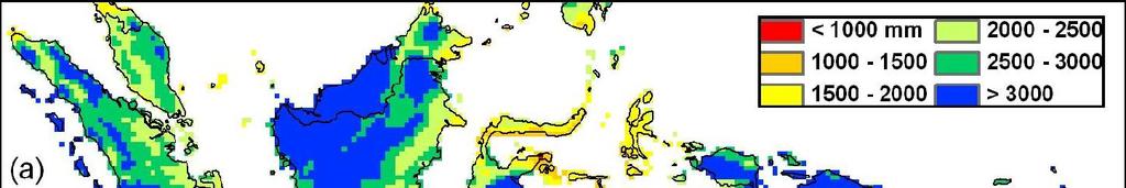
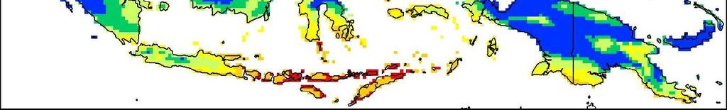
10 Development of DEWS November 22, Oldeman map (Classification) These 5 main zones are subdivided based on length of dry season 1; less than 2 dry months. No restrictions are expected with regard to available water. 2 ; 2-3 dry months. Careful planning is needed to grow crops throughout the year. 3; 4-6 dry months. A fallow period is part of the rotation system because of water constraints. 4; 7-9 dry months. Only one crop can successfully be cultivated. The remainder of the year is too dry. 5; more than 9 consecutive dry months. Areas in this subzone are generally not suitable for any cultivation of arable crops. Main Type Wet months Sub type A >9 1 <2 B C D >6 E <3 Results in a total of 18 climatic zones (14 of which in Indonesia): Dry months Development of DEWS November 22, Oldeman map m/asia/lists/cid.htm

11 Development of DEWS November 22, Compared of Oldeman map Based on TRMM data Development of DEWS November 22, Oldeman map for Indonesia (based on corrected TRMM data)
 The SPI is a simpler")


12 Development of DEWS November 22, Standard Precipitation Index (SPI) The Standard Precipitation Index (SPI) was designed to enhance the detection of onset and monitoring of drought (McKee et al, 1993) The SPI is a simpler measure of drought than the Palmer Drought Severity Index (PDSI) and is based solely on the probability of precipitation for a given time period. A key feature of the SPI is the flexibility to measure drought at different time scales. SPI value; Drought Category; 2.00 and above Extremely wet 1.50 to 1.99 Very wet 1.00 to 1.49 Moderately wet to 0.99 Near Normal to Moderately dry to Severely dry and less Extremely dry The methods are described here; documentation\spi.pdf Development of DEWS November 22, SPI map on Pemali Comal River Basin- Central Java 1 month 3 month 6 month 12 month
 Development of FEWS 21 Basic Scheme")


 Run")

13 Development of DEWS November 22, Daily and monthly rainfall forecast from ECMWF (May 1, 2011) Development of FEWS 21 Basic Scheme of FEWS Import data from external sources Run hydrological model to calculate discharge for catchments and PusAir PusAir Calculate catchment average precipitation based on rain gauge data Prepare input for hydrodynamic model based on hydrological models, gauging stations, tidal boundaries Combine precipitation sources (e.g. Rain gauge, Radar data, Meteorological Forecast models) Run hydrodynamic model to calculate water level for forecast points Create evaporation profiles for hydrological model Run error correction model to update output form hydrodynamic model


14 Development of FEWS Transformation AWS Data Read AWS-online data with xml programming for input FEWS from 22 Development of FEWS 23 Analyze AWS data and adding into FEWS system


")


15 Development of FEWS 24 Non Equidistant Transformation AWS Data Finish Equidistant (per minute with MV) in progress Fill Missing Value (MV) Subtract Aggregation Transform from Point to Grid Development of FEWS 25 Transformation TRMM to telemetry stations Transformation


16 Development of FEWS 26 Transformation TRMM to telemetry stations Development of FEWS 27 Import CCAM Data Evaporation (hourly) Precipitation (hourly)
17 Next Steps November 22, until 2015; Install server at (January) and PusAir (March) Disseminate early warning on website Operationalize seasonal forecast data (ECMWF) Feasibility studies (1) in medium range weather forecasts based on 10 years TRMM time series, (2) fire risk in peat land, (3) drought warning for specific crops, (4) forecasting reservoir storage and release. Investigate and make an assessment for climate change effects especially on water resources and agriculture in order to the increasingly floods and droughts events in Indonesia Develop Climate change scenarios based on existing climate models (seek cooperation with Australia, KNMI-the Netherlands, JMA-Japan) Configure the climate change scenarios into Delft-OMS software in order to be able to develop mitigation and adaptation strategies for the future Summary 29 The data needs for FEWS and DEWS development are meteorological/climatological and hydrological data (historical, real time and forecast) which will be integrated into one system Flood and Drought early warning systems are still in development within Joint Cooperation Program between, PusAir, KNMI and Deltares The system is developed based on Delft-OMS software and will be operational at and PusAir Further it is planned to investigate climate change effects using analysis of long-term historical data and by running climate scenarios using the Delft-OMS software in order to be able to develop mitigation and adaptation strategies for the future


18 Discussion mamenun@gmail.com, leni.nazarudin72@gmail.com, arif.abdullah@bmkg.go.id, goesploes@yahoo.com, Ronald.vernimmen@deltares.nl Terima kasih... Thank you... Dank je wel...

19


20
21
22
23


24
25

26

27
28 Drought monitoring and mapping in Indonesia under current and future climate conditions Mamenun 1, Ronald Vernimmen 2 mamenun@bmkg.go.id, mamenun@gmail.com ronald.vernimmen@deltares.nl 1 Meteorological Climatological and Geophysiscal Agency of Indonesia () Jl. Angkasa I No. 2, Jakarta Indonesia 2 Deltares, P.O.Box MH, Delft, the Netherlands International workshop on the Digitation of Historical Climate Data, the new SACA&D Database and Climate Analysis in the Asian Region, Citeko 2-5 April 2012 Outline Background Joint Cooperation Program (JCP) Drought Monitoring & Mapping a. Using ground stations b. Using sattellite observations Validation TRMM satellite data withground stations Monthly average Monthly deficit precipitation Summary Next steps Agroclimatic mapping Drought occurance in the future

29 Background Current status of the climate Droughts occur more frequently and more severe The needs; Impacts; failure of water systems (reservoirs, irrigation) which is effecting agriculture sector, destructive infrastructure and environment, social economic and contribute to enhanced fire risk. Some issues; what current condition as the result of what happened yesterday, and will happen (forecast), Development of Early Warning System and Mapping for Drought (DEWMS) data is scattered, not available in real time, not easy accessible to stakeholders, lack of quality control, spatial distribution of ground stations not always sufficient To provide integrated system for Policymakers and stakeholders to make an assessment or strategy for water resource, agriculture, environment, social economic Joint Cooperation Programme PusAir KNMI Deltares Component A; General Institutional Development Component B; Collborative Development of Customized and Standardized IWRM tools and Approaches Component C; Supporting the Development of Consistent Datasets Component D; Operational Management Support: Drought and Flood Monitoring and Warning
 Fully configurable by users (Open Interface to models and data) Platform for operational research (Short cycle from research to operations) Java, PostgreSQL/Oracle, Jboss, XML Operating system")
30 Joint Cooperation Programme JCP Framework Building DEWMS Indonesia System based on Delft-OMS = Delft-FEWS Open Shell Forecasting System System for operational forecasting (resilience!) Fully configurable by users (Open Interface to models and data) Platform for operational research (Short cycle from research to operations) Java, PostgreSQL/Oracle, Jboss, XML Operating system independent, very scalable Toolbox for development of forecasting systems Highly modular structure independent modules provide functionality Rapid implementation, scalable & flexible Automatic / manual & stand alone
 viewing (data, forecasts) archiving PI models export & dessimination Building DEWMS")
31 Building DEWMS Indonesia Concept data feeds Delft-OMS import validation transformation / interpolation data hierarchy general adapter export / report administration (data, forecasts) viewing (data, forecasts) archiving PI models export & dessimination Building DEWMS Indonesia
.")
 defined by specific regional climatology; Agricultural important droughts over 3 to 6 months (SPI-03, SPI-06) resulting in deficits in soil moisture; Longer")
32 Drought monitoring & mapping A. Using Ground Stations As a pilot, for the Pemali Comal catchment in Central Java, manual ground measurements of rainfall serve as input for calculation of the Standardized Precipitation Index (SPI). Drought monitoring & mapping A key feature of the SPI is the flexibility to measure drought at different time scales. Short term droughts of 1 month (SPI-01) defined by specific regional climatology; Agricultural important droughts over 3 to 6 months (SPI-03, SPI-06) resulting in deficits in soil moisture; Longer term droughts (months to years) have impact on surface and groundwater supplies. The severity of a drought can be compared to the average condition for a particular station or region. Values range from 2.00 and above (extremely wet) to and less (extremely dry) with near normal conditions ranging from 0.99 to SPI value; Drought Category; 2.00 and above Extremely wet 1.50 to 1.99 Very wet 1.00 to 1.49 Moderately wet to 0.99 Near Normal to Moderately dry to Severely dry and less Extremely dry


")
33 Drought monitoring & mapping Timeseries for individual stations are calculated Drought monitoring & mapping SPI-1 SPI-3 SPI-6 SPI-12 (April 2007)
 satellite data with ground stations on monthly basis Location Rain gauge Jakarta 10 3 Bogor 10 4 Bandung 13 4 Banjarbaru 15 6 East Java")
34 Drought monitoring & mapping B. Using Satellite Observations Validation of TRMM 3B42RT (TMPA) satellite data with ground stations on monthly basis Location Rain gauge Jakarta 10 3 Bogor 10 4 Bandung 13 4 Banjarbaru 15 6 East Java 15 6 Lampung 13 5 TRMM Grid Cell Source : * Vernimmen, R. R. E., Hooijer, A., Mamenun, Aldrian, E., and van Dijk, A. I. J. M.: Evaluation and bias correction of satellite rainfall data for drought monitoring in Indonesia, Hydrol. Earth Syst. Sci., 16, , doi: /hess , Drought monitoring & mapping Correction Factor: TRMMCorr= 3.20 TRMM 0.79 Validation Region Ground Stations P P Avg. diff TMPA Rel. bias RMSE R 2 P Avg. diff TMPA bias corr Rel. bias RMSE R 2 Jakarta Bogor Bandung East Java Banjar Baru Lampung Annual ground station and TMPA 3B42RT comparison before and after bias correction of TMPA 3B42RT precipitation estimates over the period Source : * Vernimmen, R. R. E., Hooijer, A., Mamenun, Aldrian, E., and van Dijk, A. I. J. M.: Evaluation and bias correction of satellite rainfall data for drought monitoring in Indonesia, Hydrol. Earth Syst. Sci., 16, , doi: /hess , 2012.


35 Drought monitoring & mapping Validation Region Ground Stations P P Avg. diff TMPA Rel. bias RMSE R 2 P Avg. diff TMPA bias corr Rel. bias RMSE R 2 Jakarta Bogor Bandung East Java Banjar Baru Lampung Dry season (June October) ground station and TMPA 3B42RT comparison before and after bias correction of TMPA 3B42RT precipitation estimates over the period Source : * Vernimmen, R. R. E., Hooijer, A., Mamenun, Aldrian, E., and van Dijk, A. I. J. M.: Evaluation and bias correction of satellite rainfall data for drought monitoring in Indonesia, Hydrol. Earth Syst. Sci., 16, , doi: /hess , Drought monitoring & mapping Validation result Source : * Vernimmen, R. R. E., Hooijer, A., Mamenun, Aldrian, E., and van Dijk, A. I. J. M.: Evaluation and bias correction of satellite rainfall data for drought monitoring in Indonesia, Hydrol. Earth Syst. Sci., 16, , doi: /hess , 2012.


36 Drought monitoring & mapping Validation result Drought monitoring & mapping TRMM satellite data are used for improved rainfall monitoring and assessing the current drought status. TRMM 3B42RT satellite precipitation (in mm) over Indonesia on 28 March :00 WIB.
 over Indonesia in March 2012. * Vernimmen, R. R. E., Hooijer, A.")
37 Drought monitoring & mapping TRMM 3B42RT satellite precipitation aggregated to monthly totals are bias corrected using the method described in Vernimmen et al *, based on validation of TRMM 3B42RT with ground stations. Bias corrected TRMM 3B42RT satellite precipitation (in mm) over Indonesia in March * Vernimmen, R. R. E., Hooijer, A., Mamenun, Aldrian, E., and van Dijk, A. I. J. M.: Evaluation and bias correction of satellite rainfall data for drought monitoring in Indonesia, Hydrol. Earth Syst. Sci., 16, , doi: /hess , Drought monitoring & mapping Climatology (monthly average) from corrected TRMM3B42RT Monthly average on March 2012.


 using data available")

38 Drought monitoring & mapping Hujan -term average). Sifat Sifat Hujan compared to long-term average Drought monitoring & mapping Monthly precipitation deficit is calculated. For evaporation, currently the CGIAR- PET * monthly dataset multiplied with a fixed crop factor of 0.8 is used. Global CGIAR-PET is a modelled dataset (1 km resolution) using data available from WorldClim Global Climate Data over the period Precipitation deficit in March The precipitation deficit needs to be linked to drought indicators for different agricultural crops *
: 1.")
39 Drought monitoring & mapping Deficit precipitation on watershed basin (DAS) for java location March 2012 * Drought monitoring & mapping Next Steps : Using the TRMM 3B42RT satellite precipitation the following will also be implemented (in progress): 1. Onset of dry season, defined as 3 consecutive decadal (10-day) periods with precipitation < 50 mm 2. Similarly, onset of the wet season 3. SPI 4. Peat fire forecasting (through running a peatland water budget model; ground water table depth is a better indicator for fire risk then precipitation alone) Other suggestions? ECMWF Seasonal Forecast data will be utilized in the near future as well.
40 Agroclimatic mapping using satellite observations Oldeman agroclimatic maps for Indonesia based on corrected monthly TRMM satellite precipitation. Classification based on number of wet and dry months in a year. Wet month = long term average > 200 mm Dry month = long term average < 100 mm used by (Ministry of Agriculture) Oldeman, L. R., Las, I., and Darwis, S. N.: An agroclimatic map of Sumatra, Contributions, Central Research Institute for Agriculture, Bogor, No. 52, 35 pp., Oldeman, L. R., Las, I., and Muladi: The agroclimatic maps of Kalimantan, Maluku, Irian Jaya and Bali, West and East Nusa Tenggara, Contributions, Central Research Institute for Agriculture, Bogor, No. 60, 32 pp., Oldeman classification 5 main zones A has more than 9 consecutive wet months. Wetland rice can be cultivated any time of the year. B has 7-9 consecutive wet months. Two wetland rice crops can be cultivated during this period. C has 5-6 consecutive wet months. Two rice crops can be cultivated only, if the first rice crop is planted (or sown) as a dry land crop (so-called gogorancah system). D has 3-4 consecutive wet months. Only one wetland rice crop is generally possible. E has less than 3 consecutive wet months. Without additional water from irrigation, wetland rice is not recommended.


41 Oldeman classification These 5 main zones are subdivided based on length of dry season 1 less than 2 dry months. No restrictions are expected with regard to available water dry months. Careful planning is needed to grow crops throughout the year dry months. A fallow period is part of the rotation system because of water constraints dry months. Only one crop can successfully be cultivated. The remainder of the year is too dry. 5 more than 9 consecutive dry months. Areas in this subzone are generally not suitable for any cultivation of arable crops. Oldeman map Indonesia Oldeman agroclimatic map based on bias corrected monthly TRMM 3B42RT (left) compared to historical map (right) for Kalimantan
 climatic map is")
 wet: > 100 mm")
42 Oldeman map Indonesia Schmidt-Ferguson Climatic map Similarly, the Schmidt-Ferguson (1951) climatic map is generated. Different definition of dry and wet month! dry: < 60 mm (whereas Oldeman < 100 mm) wet: > 100 mm (whereas Oldeman > 200 mm)
43 Drought occurrence in the future Precipitation datasets from different Global Circulation Models (GCMs) under -OMS and will be used to generate precipitation change, drought occurance, Oldeman maps, etc. These maps will help create an understanding of future drought vulnerabilities (which areas in Indonesia are vulnerable to climate change?) and will prepare for climate proofing of agricultural and water supply systems. Model Institute Country Acronym BCM2.0 Bjerknes Centre for Climate Research Norway BCCR CGCM3.1 Canadian Centre for Climate modelling and Analysis Canada CCCMA CGCM2.3.2 Meteorological Research Institute Japan CGCM CSIRO-Mk3.0 Commonwealth Scientific and Industrial Research Organisation Australia CSIRO ECHAM5 Max Planck Institute Germany ECHAM ECHO-G Freie Universität Berlin Berlin ECHO GFDLCM 2.0 Geophysical Fluid Dynamics Centre USA GFDL GISS ER Goddard institute for Space Studies USA GISS IPSL CM4 Institute Pierre Simon Laplace France IPSL MIROC3.2 Center of Climate System Research Japan MIROC NCAR PCMI National Center for Atmospheric Research USA NCAR HadGEM2 UK HADGEM Summary Drought monitoring and mapping both using ground stations and validated sattellite observation has been made as part of the development of Drought Early Warning and Mapping System The average monthly and characteristic of climatology (sifat hujan), deficit corrected satellite data The correction sattellite data will be applied on calculating SPI index, decadal precipitation for wet and dry onset, peat fire forecasting, and climate type ECMWF Seasonal Forecast data will be utilized in the near future as well. The climate scenario will be applied to project the drought occurance in the future
44
45 Climate Impact Assessment in Indonesia Using Bias Corrected TRMM and Climate Scenario s from Different GCMs Mamenun 1, Budi Setiawan 1, Endar Pangestuti 1, Ronald Vernimmen 2 1 Center for Climate Change and Air Quality The Indonesian Agency for Meteorology, Climatology and Geophysics Jl. Angkasa 1 No. 2 Kemayoran, Central Jakarta, Indonesia 2 Deltares, P.O.Box MH, Delft, the Netherlands mamenun@bmkg.go.id, budbey@yahoo.com, endarpangestuti@gmail.com, ronald.vernimmen@deltares.nl ABSTRACT Indonesia is a tropical country and most parts of it receive abundant annual rainfall, in excess of 1800 mm per year. In many areas, however, rainfall is highly seasonal, and sometimes erratic. In such regions, prolonged water deficits lasting several months occasionally cause failures of water supply systems and of rain fed and irrigated crops, and frequently contribute to enhanced fire risk in forests and peat land areas. Monitoring and understanding dry season rainfall patterns, in time and space, is therefore important for the country to be prepared for water shortages, food shortages and fires. In order to tackle these issues a Drought Early Warning and Mapping System (DEWMS) for the whole of Indonesia is currently being developed using Delft-OMS software under a Joint Cooperation Program with, PusAir, KNMI and Deltares. The drought frequency and severity maps produced with this system are based on bias corrected TRMM satellite rainfall data. The bias correction was derived after a comparative analysis with ground station data in six regions. The corrected TRMM satellite rainfall data has been used to calculate climatology of rainfall, deficit water on river basin in Java Island and Oldeman agroclimatic maps for 3 provinces located on different islands. In addition to the development of DEWMS, Delft-OMS software is also used to prepare GCM data for Indonesia in order to be used in climate impact assessments. Currently, A1B IPCC scenario s from several GCM models; CSIRO, ECHAM, CCCMA and CGCM model, have been downscaled, bias corrected using the CRU-ERA40 dataset and stored in the system. The corrected GCM models have been used to project the rainfall, to assess rainfall climatology, and to build the Oldeman agroclimatic maps. For this future projection, it showed that the building of baseline datasets based on Indonesia s rain gauge are very needed to have a better projection in Indonesia. After an analysis of the drought conditions and associated vulnerabilities within Indonesia under the current climate, rainfall projections from the different GCMs will be analysed to determine the impact of the different climate scenario s. The maps and analysis will provide insight and understanding of drought patterns needed for many aspects of water and land management in Indonesia: not only drought preparedness but also climate proofing of agricultural and water supply systems for the future. Keywords: satellite rainfall, drought maps, GCM data, climate impact assessment.
Workshop on MCCOE Radar Meteorology /Climatology in Indonesia. Segel Ginting Wanny K. Adidarma
 Workshop on MCCOE Radar Meteorology /Climatology in Indonesia BPPT, 28 Februari 2013 JAKARTA FLOOD EARLY WARNING SYSTEM (J-FEWS) Segel Ginting Wanny K. Adidarma JCP (Joint Cooperation Program) Indonesia
NATIONAL FRAMEWORK FOR FLOOD DISASTER MANAGEMENT IN INDONESIA. 11 th GEOSS ASIA PASIFIC SYMPOSIUM Kyoto, October 2018
 NATIONAL FRAMEWORK FOR FLOOD DISASTER MANAGEMENT IN INDONESIA 11 th GEOSS ASIA PASIFIC SYMPOSIUM Kyoto, 24-26 October 2018 1 OUTLINE Disasters in Indonesia The Disaster Management Mechanism Current Status
Operational Practices in South African Weather Service (SAWS)
") Operational Practices in South African Weather Service (SAWS) Abiodun Adeola, Hannes Rautenbach, Cobus Olivier 2018/06/12 1 Overview Seasonal Forecasting System at SAWS How to Interpret Seasonal Forecasts
Operational Practices in South African Weather Service (SAWS) Abiodun Adeola, Hannes Rautenbach, Cobus Olivier 2018/06/12 1 Overview Seasonal Forecasting System at SAWS How to Interpret Seasonal Forecasts
Food Security Monitoring Bulletin. INDONESIA Special Focus: Estimating Impact of Disasters on Market Access
 Food Security Monitoring Bulletin INDONESIA Special Focus: Estimating Impact of Disasters on Market Access Volume 10, May 2018 CLIMATE AND FOOD SECURITY January - April 2018 More floods and landslides
Project Name: Implementation of Drought Early-Warning System over IRAN (DESIR)
") Project Name: Implementation of Drought Early-Warning System over IRAN (DESIR) IRIMO's Committee of GFCS, National Climate Center, Mashad November 2013 1 Contents Summary 3 List of abbreviations 5 Introduction
Project Name: Implementation of Drought Early-Warning System over IRAN (DESIR) IRIMO's Committee of GFCS, National Climate Center, Mashad November 2013 1 Contents Summary 3 List of abbreviations 5 Introduction
Extending the use of Flood Modeller Pro towards operational forecasting with Delft-FEWS
 Extending the use of Flood Modeller Pro towards operational forecasting with Delft-FEWS Simone van Schijndel, Department Head Operational Water Management and Early Warning Intentionally blank The world
INVESTIGATING THE SIMULATIONS OF HYDROLOGICAL and ENERGY CYCLES OF IPCC GCMS OVER THE CONGO AND UPPER BLUE NILE BASINS
 INVESTIGATING THE SIMULATIONS OF HYDROLOGICAL and ENERGY CYCLES OF IPCC GCMS OVER THE CONGO AND UPPER BLUE NILE BASINS Mohamed Siam, and Elfatih A. B. Eltahir. Civil & Environmental Engineering Department,
Indices and Indicators for Drought Early Warning
 Indices and Indicators for Drought Early Warning ADRIAN TROTMAN CHIEF, APPLIED METEOROLOGY AND CLIMATOLOGY CARIBBEAN INSTITUTE FOR METEOROLOGY AND HYDROLOGY IN COLLABORATION WITH THE NATIONAL DROUGHT MITIGATION
JOINT COOPERATION PROGRAMME
 JOINT COOPERATION PROGRAMME Component D1: Droughts Early Warning System Document D1.2 PPPs training on Use of PCRaster, NetCDF and grib data BMKG, Jakarta 1-4 August 2011 Project: 1201430.000 Client: Water
Chiang Rai Province CC Threat overview AAS1109 Mekong ARCC
 Chiang Rai Province CC Threat overview AAS1109 Mekong ARCC This threat overview relies on projections of future climate change in the Mekong Basin for the period 2045-2069 compared to a baseline of 1980-2005.
Understanding Weather and Climate Risk. Matthew Perry Sharing an Uncertain World Conference The Geological Society, 13 July 2017
 Understanding Weather and Climate Risk Matthew Perry Sharing an Uncertain World Conference The Geological Society, 13 July 2017 What is risk in a weather and climate context? Hazard: something with the
By Lillian Ntshwarisang Department of Meteorological Services Phone:
 By Lillian Ntshwarisang Department of Meteorological Services Phone: +267 3612200 Email: lntshwarisang@gov.bw/ lntshwarisang@gmail.com Introduction Mandate of DMS Function of the Department Services to
Experiments with Statistical Downscaling of Precipitation for South Florida Region: Issues & Observations
 Experiments with Statistical Downscaling of Precipitation for South Florida Region: Issues & Observations Ramesh S. V. Teegavarapu Aneesh Goly Hydrosystems Research Laboratory (HRL) Department of Civil,
SPI: Standardized Precipitation Index
 PRODUCT FACT SHEET: SPI Africa Version 1 (May. 2013) SPI: Standardized Precipitation Index Type Temporal scale Spatial scale Geo. coverage Precipitation Monthly Data dependent Africa (for a range of accumulation
 http://www.ukm.edu.my/seaclid-cordex/ Addressing future climate change information gaps and data needs in the Southeast Asia region through the Southeast Asia Regional Climate Downscaling (SEACLID)/CORDEX
Drought Monitoring in Mainland Portugal
 Drought Monitoring in Mainland Portugal 1. Accumulated precipitation since 1st October 2014 (Hydrological Year) The accumulated precipitation amount since 1 October 2014 until the end of April 2015 (Figure
Combining sensor and forecast information to aid decision making: real-time determination of hydrological peat fire risk in Kalimantan
 Combining sensor and forecast information to aid decision making: real-time determination of hydrological peat fire risk in Kalimantan Jaap Schellekens Based on work by: Aljosja Hooijer, Ronald Vernimmen,
NATIONAL HYDROPOWER ASSOCIATION MEETING. December 3, 2008 Birmingham Alabama. Roger McNeil Service Hydrologist NWS Birmingham Alabama
 NATIONAL HYDROPOWER ASSOCIATION MEETING December 3, 2008 Birmingham Alabama Roger McNeil Service Hydrologist NWS Birmingham Alabama There are three commonly described types of Drought: Meteorological drought
Climate Risk Profile for Samoa
 Climate Risk Profile for Samoa Report Prepared by Wairarapa J. Young Samoa Meteorology Division March, 27 Summary The likelihood (i.e. probability) components of climate-related risks in Samoa are evaluated
Drought Monitoring with Hydrological Modelling
 st Joint EARS/JRC International Drought Workshop, Ljubljana,.-5. September 009 Drought Monitoring with Hydrological Modelling Stefan Niemeyer IES - Institute for Environment and Sustainability Ispra -
Supplementary Material: Characterizing Changes in Drought Risk for the United States from Climate Change [1] October 12, 2010
![Supplementary Material: Characterizing Changes in Drought Risk for the United States from Climate Change [1] October 12, 2010](/thumbs/78/77629162.jpg "Supplementary Material: Characterizing Changes in Drought Risk for the United States from Climate Change [1] October 12, 2010") Supplementary Material: Characterizing Changes in Drought Risk for the United States from Climate Change [1] Kenneth Strzepek a, Gary Yohe b, James Neumann c, Brent Boehlert d October 12, 2010 a Visiting
Supplementary Material: Characterizing Changes in Drought Risk for the United States from Climate Change [1] Kenneth Strzepek a, Gary Yohe b, James Neumann c, Brent Boehlert d October 12, 2010 a Visiting
Statistical downscaling of multivariate wave climate using a weather type approach
 COWPLIP Workshop on Coordinated Global Wave Climate Projections Statistical downscaling of multivariate wave climate using a weather type approach Melisa Menendez, Fernando J. Mendez, Cristina Izaguirre,
Climate Risk Management and Tailored Climate Forecasts
 Climate Risk Management and Tailored Climate Forecasts Andrew W. Robertson Michael K. Tippett International Research Institute for Climate and Society (IRI) New York, USA SASCOF-1, April 13-15, 2010 outline
Agrometeorological activities in RHMSS
 Republic of Serbia Republic Hydrometeorological Service of Serbia Agrometeorological activities in RHMSS Department for applied climatology and agrometeorology www.hidmet.gov.rs Meteorological Observing
Country Presentation-Nepal
 Country Presentation-Nepal Mt.Everest, Shiva Pd. Nepal, DHM South Asia Drought Monitor Workshop Dhaka Bangladesh 2 th April 215 Overview Brief Climatology Climate activities- DHM PPCR (Pilot Program for
South Asian Climate Outlook Forum (SASCOF-6)
") Sixth Session of South Asian Climate Outlook Forum (SASCOF-6) Dhaka, Bangladesh, 19-22 April 2015 Consensus Statement Summary Below normal rainfall is most likely during the 2015 southwest monsoon season
Sixth Session of South Asian Climate Outlook Forum (SASCOF-6) Dhaka, Bangladesh, 19-22 April 2015 Consensus Statement Summary Below normal rainfall is most likely during the 2015 southwest monsoon season
Customizable Drought Climate Service for supporting different end users needs
 1 Customizable Drought Climate Service for supporting different end users needs Ramona MAGNO, T. De Filippis, E. Di Giuseppe, M. Pasqui, E. Rapisardi, L. Rocchi (IBIMET-CNR; LaMMA Consortium) 1 Congresso
Creating a WeatherSMART nation: SAWS drought related research, services and products
 Creating a WeatherSMART nation: SAWS drought related research, services and products Drought Dialogue 23-24 June 2016 Western Cape Government Hannes Rautenbach South African Weather Service SAWS mandate
Application of Satellite Data for Flood Forecasting and Early Warning in the Mekong River Basin in South-east Asia
 MEKONG RIVER COMMISSION Vientiane, Lao PDR Application of Satellite Data for Flood Forecasting and Early Warning in the Mekong River Basin in South-east Asia 4 th World Water Forum March 2006 Mexico City,
Extremes Events in Climate Change Projections Jana Sillmann
 Extremes Events in Climate Change Projections Jana Sillmann Max Planck Institute for Meteorology International Max Planck Research School on Earth System Modeling Temperature distribution IPCC (2001) Outline
Caribbean Early Warning System Workshop
 Caribbean Early Warning System Workshop Hamonization in Existing EWS April 14-16, 2016 Presenter: Shawn Boyce Caribbean Institute for Meteorology and Hydrology Husbands, St. James Barbados Background Between
National Report on Weather Forecasting Service
 MINISTRY OF WATER RESOURCES AND METEOROLOGY DEPARTMENT OF METEOROLOGY, CAMBODIA National Report on Weather Forecasting Service Tokyo, 11-15 March 2014 Department of Meteorology, Cambodia Presentation Outline
World Meteorological Organization
 World Meteorological Organization Opportunities and Challenges for Development of Weather-based Insurance and Derivatives Markets in Developing Countries By Maryam Golnaraghi, Ph.D. Head of WMO Disaster
DEVELOPMENT OF A FORECAST EARLY WARNING SYSTEM ethekwini Municipality, Durban, RSA. Clint Chrystal, Natasha Ramdass, Mlondi Hlongwae
 DEVELOPMENT OF A FORECAST EARLY WARNING SYSTEM ethekwini Municipality, Durban, RSA Clint Chrystal, Natasha Ramdass, Mlondi Hlongwae LOCATION DETAILS AND BOUNDARIES ethekwini Municipal Area = 2297 km 2
KEY ACHIEVEMENTS, LESSON LEARNT AND SUGGESTIONS FOR FUTURE OPPORTUNITIES
 KEY ACHIEVEMENTS, LESSON LEARNT AND SUGGESTIONS FOR FUTURE OPPORTUNITIES The project of Strengthening Multi-Hazard Risk Assessment and Early Warning Systems in Pacific Islands Countries Center for Public
Seasonal Hydrological Forecasting in the Berg Water Management Area of South Africa
 Seasonal Hydrological Forecasting in the Berg Water Management Area of South Africa Trevor LUMSDEN and Roland SCHULZE University of KwaZulu-Natal, South Africa OUTLINE Introduction Objectives Study Area
Supplementary Figure S1: Uncertainty of runoff changes Assessments of. R [mm/yr/k] for each model and the ensemble mean.
![Supplementary Figure S1: Uncertainty of runoff changes Assessments of. R [mm/yr/k] for each model and the ensemble mean.](/thumbs/91/104794017.jpg "Supplementary Figure S1: Uncertainty of runoff changes Assessments of. R [mm/yr/k] for each model and the ensemble mean.") Supplementary Figure S1: Uncertainty of runoff changes Assessments of R [mm/yr/k] for each model and the ensemble mean. 1 Supplementary Figure S2: Schematic diagrams of methods The top panels show uncertainty
Supplementary Figure S1: Uncertainty of runoff changes Assessments of R [mm/yr/k] for each model and the ensemble mean. 1 Supplementary Figure S2: Schematic diagrams of methods The top panels show uncertainty
SEACLID/CORDEX Southeast Asia: A Regional Initiative to Provide Regional Climate Change Information and Capacity Building
 SEACLID/CORDEX Southeast Asia: A Regional Initiative to Provide Regional Climate Change Information and Capacity Building Liew Ju Neng SEACLID/CORDEX Southeast Asia School of Environment and Natural Sciences
National Public Weather and Warning Services in the Swaziland Meteorological Service Dennis S.Mkhonta /
 National Public Weather and Warning Services in the Swaziland Meteorological Service Dennis S.Mkhonta dennis.mkhonta@gmail.com / dennis@swazimet.gov.sz Introduction Swaziland s geographical position exposes
Drylands face potential threat under 2 C global warming target
 In the format provided by the authors and unedited. SUPPLEMENTARY INFORMATION DOI: 10.1038/NCLIMATE3275 Drylands face potential threat under 2 C global warming target Jianping Huang 1 *, Haipeng Yu 1,
EARLY WARNING IN SOUTHERN AFRICA:
 EARLY WARNING IN SOUTHERN AFRICA: Enhancing the Meteorological Early Warning System Eugene Poolman South African Weather Service OUTLINE OF PRESENTATION Impact of Climate Change Meteorological Early Warning
Arizona Drought Monitoring Sensitivity and Verification Analyses
 Arizona Drought Monitoring Sensitivity and Verification Analyses A Water Sustainability Institute, Technology and Research Initiative Fund Project Christopher L. Castro, Francina Dominguez, Stephen Bieda
SUPPLEMENTARY INFORMATION
 SUPPLEMENTARY INFORMATION DOI: 10.1038/NGEO1189 Different magnitudes of projected subsurface ocean warming around Greenland and Antarctica Jianjun Yin 1*, Jonathan T. Overpeck 1, Stephen M. Griffies 2,
Weather Satellite Data Applications for Monitoring and Warning Hazard at BMKG
 The 5th Meeting of the Coordinating Group of the RA II WIGOS Satellite Project 21 October 2017, Vladivostok city, Russky Island, Russia Far Eastern Federal University Weather Satellite Data Applications
GIS in Weather and Society
 GIS in Weather and Society Olga Wilhelmi Institute for the Study of Society and Environment National Center for Atmospheric Research WAS*IS November 8, 2005 Boulder, Colorado Presentation Outline GIS basic
DROUGHT ASSESSMENT USING SATELLITE DERIVED METEOROLOGICAL PARAMETERS AND NDVI IN POTOHAR REGION
 DROUGHT ASSESSMENT USING SATELLITE DERIVED METEOROLOGICAL PARAMETERS AND NDVI IN POTOHAR REGION Researcher: Saad-ul-Haque Supervisor: Dr. Badar Ghauri Department of RS & GISc Institute of Space Technology
Flood Forecasting Tools for Ungauged Streams in Alberta: Status and Lessons from the Flood of 2013
 Flood Forecasting Tools for Ungauged Streams in Alberta: Status and Lessons from the Flood of 2013 John Pomeroy, Xing Fang, Kevin Shook, Tom Brown Centre for Hydrology, University of Saskatchewan, Saskatoon
Climate Change Scenario, Climate Model and Future Climate Projection
 Training on Concept of Climate Change: Impacts, Vulnerability, Adaptation and Mitigation 6 th December 2016, CEGIS, Dhaka Climate Change Scenario, Climate Model and Future Climate Projection A.K.M. Saiful
National Weather Service Flood Forecast Needs: Improved Rainfall Estimates
 National Weather Service Flood Forecast Needs: Improved Rainfall Estimates Weather Forecast Offices Cleveland and Northern Indiana Ohio River Forecast Center Presenter: Sarah Jamison, Service Hydrologist
Flash flood forecasting and warning infrastructures of National Meteorology and Hydrological Services of Cambodia
 Development and Implementation of the South East Asia Flash Flood Guidance System (SEAFFGS) Ha Noi, Viet Nam, 20-23 November 2017 Flash flood forecasting and warning infrastructures of National Meteorology
Keynote Address. Development of Multi-Hazard Early Warning System in Indonesia by Prof. Armi Susandi, PhD
 Keynote Address Development of Multi-Hazard Early Warning System in Indonesia by Prof. Armi Susandi, PhD Professor of Meteorology, Bandung Institute of Technology, Indonesia. Dr. Susandi is an expert in
Flash Flood Guidance System On-going Enhancements
 Flash Flood Guidance System On-going Enhancements Hydrologic Research Center, USA Technical Developer SAOFFG Steering Committee Meeting 1 10-12 July 2017 Jakarta, INDONESIA Theresa M. Modrick Hansen, PhD
Regional Flash Flood Guidance and Early Warning System
 WMO Training for Trainers Workshop on Integrated approach to flash flood and flood risk management 24-28 October 2010 Kathmandu, Nepal Regional Flash Flood Guidance and Early Warning System Dr. W. E. Grabs
Future freshwater stress for island populations
 Future freshwater stress for island populations Kristopher B. Karnauskas, Jeffrey P. Donnelly and Kevin J. Anchukaitis Summary: Top left: Overview map of the four island stations located in the U.S. state
Summary and Conclusions
 241 Chapter 10 Summary and Conclusions Kerala is situated in the southern tip of India between 8 15 N and 12 50 N latitude and 74 50 E and 77 30 E longitude. It is popularly known as Gods own country.
Analysis of Meteorological drought condition for Bijapur region in the lower Bhima basin, India
 Analysis of Meteorological drought condition for Bijapur region in the lower Bhima basin, India Mamatha.K PG Student Department of WLM branch VTU, Belagavi Dr. Nagaraj Patil Professor and Head of the Department
The U.S. National Integrated Drought Information System. Roger S. Pulwarty National Oceanic and Atmospheric Administration USA
 The U.S. National Integrated Drought Information System Roger S. Pulwarty National Oceanic and Atmospheric Administration USA Drought: Weather-climate continuum and adaptation deficits 2010 2011 2012 2015
Drought in a Warming Climate: Causes for Change
 Drought in a Warming Climate: Causes for Change Dr. Guiling Wang (guiling.wang@uconn.edu) Department of Civil and Environmental Engineering University of Connecticut Storrs, CT 06269, USA http://hydroclimatology.uconn.edu/
Downscaled Climate Change Projection for the Department of Energy s Savannah River Site
 Downscaled Climate Change Projection for the Department of Energy s Savannah River Site Carolinas Climate Resilience Conference Charlotte, North Carolina: April 29 th, 2014 David Werth Atmospheric Technologies
Ramesh Vellore. CORDEX Team: R. Krishnan, T.P. Sabin, J. Sanjay, Milind Mujumdar, Sandip Ingle, P. Priya, M.V. Rama Rao, and Madhura Kane
 Ramesh Vellore CORDEX Team: R. Krishnan, T.P. Sabin, J. Sanjay, Milind Mujumdar, Sandip Ingle, P. Priya, M.V. Rama Rao, and Madhura Kane Centre for Climate Change Research Indian Institute of Tropical
COUNTRY REPORT. Jakarta. July, th National Directorate of Meteorology and Geophysics of Timor-Leste (DNMG)
") The Southeastern Asia-Oceania Flash Flood COUNTRY REPORT Jakarta. July, 10-12 th 2017 National Directorate of Meteorology and Geophysics of Timor-Leste (DNMG) Carla Feritas and Crisostimo Lobato Democratic
The Southeastern Asia-Oceania Flash Flood COUNTRY REPORT Jakarta. July, 10-12 th 2017 National Directorate of Meteorology and Geophysics of Timor-Leste (DNMG) Carla Feritas and Crisostimo Lobato Democratic
S16. ASSESSING THE CONTRIBUTIONS OF EAST AFRICAN AND WEST PACIFIC WARMING TO THE 2014 BOREAL SPRING EAST AFRICAN DROUGHT
 S6. ASSESSING THE CONTRIBUTIONS OF EAST AFRICAN AND WEST PACIFIC WARMING TO THE 204 BOREAL SPRING EAST AFRICAN DROUGHT Chris Funk, Shraddhanand Shukla, Andy Hoell, and Ben Livneh This document is a supplement
20 ~ 23 MAY 2014 Indonesia Regional Training Center Citeko, Bogor, Indonesia. Jointly organized by the NMHS s of
 International ASEAN SACA&D Conference and Workshop 2014 (IASCW-2014) Past, Present and Future; a display of climate science and services in South East Asia 20 ~ 23 MAY 2014 Indonesia Regional Training
Drought forecasting and warning in Africa Some experiences & thoughts from the DEWFORA project
 Drought forecasting and warning in Africa Some experiences & thoughts from the DEWFORA project Micha Werner 1 & Gilbert Ouma 2 1 Deltares & UNESCO-IHE, the Netherlands 2 ICPAC & University of Nairobi,
Drought Criteria. Richard J. Heggen Department of Civil Engineering University of New Mexico, USA Abstract
 Drought Criteria Richard J. Heggen Department of Civil Engineering University of New Mexico, USA rheggen@unm.edu Abstract Rainwater catchment is an anticipatory response to drought. Catchment design requires
BUREAU OF METEOROLOGY
 BUREAU OF METEOROLOGY Building an Operational National Seasonal Streamflow Forecasting Service for Australia progress to-date and future plans Dr Narendra Kumar Tuteja Manager Extended Hydrological Prediction
SEASONAL RAINFALL FORECAST FOR ZIMBABWE. 28 August 2017 THE ZIMBABWE NATIONAL CLIMATE OUTLOOK FORUM
 2017-18 SEASONAL RAINFALL FORECAST FOR ZIMBABWE METEOROLOGICAL SERVICES DEPARTMENT 28 August 2017 THE ZIMBABWE NATIONAL CLIMATE OUTLOOK FORUM Introduction The Meteorological Services Department of Zimbabwe
The CLIMGEN Model. More details can be found at and in Mitchell et al. (2004).
.") Provided by Tim Osborn Climatic Research Unit School of Environmental Sciences University of East Anglia Norwich NR4 7TJ, UK t.osborn@uea.ac.uk The CLIMGEN Model CLIMGEN currently produces 8 climate variables
Provided by Tim Osborn Climatic Research Unit School of Environmental Sciences University of East Anglia Norwich NR4 7TJ, UK t.osborn@uea.ac.uk The CLIMGEN Model CLIMGEN currently produces 8 climate variables
South Asian Climate Outlook Forum (SASCOF-12)
") Twelfth Session of South Asian Climate Outlook Forum (SASCOF-12) Pune, India, 19-20 April 2018 Consensus Statement Summary Normal rainfall is most likely during the 2018 southwest monsoon season (June
Twelfth Session of South Asian Climate Outlook Forum (SASCOF-12) Pune, India, 19-20 April 2018 Consensus Statement Summary Normal rainfall is most likely during the 2018 southwest monsoon season (June
The Palfai Drought Index (PaDI) Expansion of applicability of Hungarian PAI for South East Europe (SEE) region Summary
 Expansion of applicability of Hungarian PAI for South East Europe (SEE) region Summary") The Palfai Drought Index () Expansion of applicability of Hungarian PAI for South East Europe (SEE) region Summary In Hungary the Palfai drought index (PAI) worked out for users in agriculture and in water
The Palfai Drought Index () Expansion of applicability of Hungarian PAI for South East Europe (SEE) region Summary In Hungary the Palfai drought index (PAI) worked out for users in agriculture and in water
DROUGHT IN MAINLAND PORTUGAL
 DROUGHT IN MAINLAND Ministério da Ciência, Tecnologia e Ensino Superior Instituto de Meteorologia, I. P. Rua C Aeroporto de Lisboa Tel.: (351) 21 844 7000 e-mail:informacoes@meteo.pt 1749-077 Lisboa Portugal
STI for Climate Extremes
 STI for Climate Extremes Fredolin Tangang Professor, Universiti Kebangsaan Malaysia Adjunct Professor, Ramkhamhaeng University, Bangkok, Thailand SEP Member, NADMA Fellow, Academy of Science Malaysia Bengkel
Visualising and communicating probabilistic flow forecasts in The Netherlands
 Visualising and communicating probabilistic flow forecasts in The Netherlands Eric Sprokkereef Centre for Water Management Division Crisis Management & Information Supply 2-2-2009 Content The basins Forecasting
ANALYSIS OF FLOODS AND DROUGHTS IN THE BAGO RIVER BASIN, MYANMAR, UNDER CLIMATE CHANGE
 ANALYSIS OF FLOODS AND DROUGHTS IN THE BAGO RIVER BASIN, MYANMAR, UNDER CLIMATE CHANGE Myo Myat Thu* MEE15631 ABSTRACT 1 Supervisor: Dr. Maskym Gusyev** Dr. Akira Hasegawa** This study investigates floods
Tonga Country Report
 Tonga Country Report Tonga Meteorological Services Ph. (676)35355 email: metstaff@met.gov.to Joint Meeting of RA II WIGOS Project and RA V TT-SU Jakarta, Indonesia / 11 October 2018 BMKG Headquarter Outline
SUPPLEMENTARY INFORMATION
 1 Supplementary Methods Downscaling of global climate model data Global Climate Model data were dynamically downscaled by the Regional Climate Model (RCM) CLM 1 (http://clm.gkss.de/, meanwhile renamed
Recent development of the National Hydro-Meteorological Service (NHMS) of Viet Nam for disaster risk reduction
 of Viet Nam for disaster risk reduction") Ministry of Natural Resources and Environment National Hydro-Meteorological Service Recent development of the National Hydro-Meteorological Service (NHMS) of Viet Nam for disaster risk reduction Tran Van
Ministry of Natural Resources and Environment National Hydro-Meteorological Service Recent development of the National Hydro-Meteorological Service (NHMS) of Viet Nam for disaster risk reduction Tran Van
2006 Drought in the Netherlands (20 July 2006)
") 2006 Drought in the Netherlands (20 July 2006) Henny A.J. van Lanen, Wageningen University, the Netherlands (henny.vanlanen@wur.nl) The Netherlands is suffering from tropical heat and it is facing a meteorological
2006 Drought in the Netherlands (20 July 2006) Henny A.J. van Lanen, Wageningen University, the Netherlands (henny.vanlanen@wur.nl) The Netherlands is suffering from tropical heat and it is facing a meteorological
Analysis of real-time prairie drought monitoring and forecasting system. Lei Wen and Charles A. Lin
 Analysis of real-time prairie drought monitoring and forecasting system Lei Wen and Charles A. Lin Back ground information A real-time drought monitoring and seasonal prediction system has been developed
Climate Indices and Indicators for Agriculture
 Climate Indices and Indicators for Agriculture ADRIAN TROTMAN CHIEF, A PPLIED M ETEOROLOGY A ND CLIMATOLOGY CARIBBEAN INSTITUTE FOR METEOROLOGY AND HYDROLOGY WMO WORKSHOP ON ENHANCING CLIMATE INDICES FOR
The North American Drought Monitor - The Canadian Perspective -
 The North American Drought Monitor - The Canadian Perspective - Trevor Hadwen National Agroclimate Information Service AAFC-PFRA, Regina Canmore, Alberta March 16-18, 2008 Background The NADM is a cooperative
Drought Trends and Projections (Drought trends over and projections until 2100)
") Drought Trends and Projections (Drought trends over 1951-2016 and projections until 2100) Jonathan Spinoni, PhD European Commission JRC - Unit E1 (Disaster Risk Management) Email: jonathan.spinoni@ec.europa.eu
Drought Trends and Projections (Drought trends over 1951-2016 and projections until 2100) Jonathan Spinoni, PhD European Commission JRC - Unit E1 (Disaster Risk Management) Email: jonathan.spinoni@ec.europa.eu
SWIM and Horizon 2020 Support Mechanism
 SWIM and Horizon 2020 Support Mechanism Working for a Sustainable Mediterranean, Caring for our Future REG-7: Training Session #1: Drought Hazard Monitoring Example from real data from the Republic of
Global Flash Flood Guidance System Status and Outlook
 Global Flash Flood Guidance System Status and Outlook HYDROLOGIC RESEARCH CENTER San Diego, CA 92130 http://www.hrcwater.org Initial Planning Meeting on the WMO HydroSOS, Entebbe, Uganda 26-28 September
Global Challenges - Partnering with Service Providers. World Meteorological Organization. J. Lengoasa WMO Deputy Secretary-General
 WMO World Meteorological Organization Working together in weather, climate and water Global Challenges - Partnering with Service Providers J. Lengoasa WMO Deputy Secretary-General jlengoasa@wmo.int http://www.wmo.int/pages/gfcs/gfcs_en.html
MONITORING OF SURFACE WATER RESOURCES IN THE MINAB PLAIN BY USING THE STANDARDIZED PRECIPITATION INDEX (SPI) AND THE MARKOF CHAIN MODEL
 AND THE MARKOF CHAIN MODEL") MONITORING OF SURFACE WATER RESOURCES IN THE MINAB PLAIN BY USING THE STANDARDIZED PRECIPITATION INDEX (SPI) AND THE MARKOF CHAIN MODEL Bahari Meymandi.A Department of Hydraulic Structures, college of
MONITORING OF SURFACE WATER RESOURCES IN THE MINAB PLAIN BY USING THE STANDARDIZED PRECIPITATION INDEX (SPI) AND THE MARKOF CHAIN MODEL Bahari Meymandi.A Department of Hydraulic Structures, college of
The indicator can be used for awareness raising, evaluation of occurred droughts, forecasting future drought risks and management purposes.
 INDICATOR FACT SHEET SSPI: Standardized SnowPack Index Indicator definition The availability of water in rivers, lakes and ground is mainly related to precipitation. However, in the cold climate when precipitation
COUNTRY REPORT INDONESIA
 COUNTRY REPORT INDONESIA Badan Meteorologi Klimatologi dan Geofisika (BMKG) Agency For Meteorology, Climatology, and Geophysics Republic of Indonesia DKI Jakarta, Indonesia Tel. (021) 4246321 Email: pcs@bmkg.go.id
The Huong River the nature, climate, hydro-meteorological issues and the AWCI demonstration project
 The Huong River the nature, climate, hydro-meteorological issues and the AWCI demonstration project 7th GEOSS AP Symposium, the AWCI parallel session May 27, 214, Tokyo National Centre for Hydro-Meteorological
Emerging Needs, Challenges and Response Strategy
 Emerging Needs, Challenges and Response Strategy Development of Integrated Observing Systems in China JIAO Meiyan Deputy Administrator China Meteorological Administration September 2011 Geneva Outline
2007: The Netherlands in a drought again (2 May 2007)
") 2007: The Netherlands in a drought again (2 May 2007) Henny A.J. van Lanen, Wageningen University, the Netherlands (henny.vanlanen@wur.nl) Like in June and July 2006, the Netherlands is again facing a
2007: The Netherlands in a drought again (2 May 2007) Henny A.J. van Lanen, Wageningen University, the Netherlands (henny.vanlanen@wur.nl) Like in June and July 2006, the Netherlands is again facing a
Drought News August 2014
 European Drought Observatory (EDO) Drought News August 2014 (Based on data until the end of July) http://edo.jrc.ec.europa.eu August 2014 EDO (http://edo.jrc.ec.europa.eu) Page 2 of 8 EDO Drought News
INDONESIA IMPACT BASED FORECAST PROGRAM
 INDONESIA IMPACT BASED FORECAST PROGRAM Seoul, 19-21 November 2018 The 2nd Regional Workshop on Impact-based Forecasts in Asia Indonesia Agency for Meteorology Climatology and Geophysics (BMKG) A. Fachri
URBAN DRAINAGE MODELLING
 9th International Conference URBAN DRAINAGE MODELLING Evaluating the impact of climate change on urban scale extreme rainfall events: Coupling of multiple global circulation models with a stochastic rainfall
United States Multi-Hazard Early Warning System
 United States Multi-Hazard Early Warning System Saving Lives Through Partnership Lynn Maximuk National Weather Service Director, Central Region Kansas City, Missouri America s s Weather Enterprise: Protecting
NARCliM Technical Note 1. Choosing GCMs. Issued: March 2012 Amended: 29th October Jason P. Evans 1 and Fei Ji 2
 NARCliM Technical Note 1 Issued: March 2012 Amended: 29th October 2012 Choosing GCMs Jason P. Evans 1 and Fei Ji 2 1 Climate Change Research Centre, University of New South Wales, Sydney, Australia 2 New
Doug Kluck NOAA Kansas City, MO National Center for Environmental Information (NCEI) National Integrated Drought Information System (NIDIS)
 National Integrated Drought Information System (NIDIS)") National Integrated Drought Information System (NIDIS) for the Missouri River Basin Drought Early Warning Information System (DEWS) & Runoff Trends in the Missouri Basin & Latest Flood Outlook Doug Kluck
National Integrated Drought Information System (NIDIS) for the Missouri River Basin Drought Early Warning Information System (DEWS) & Runoff Trends in the Missouri Basin & Latest Flood Outlook Doug Kluck
2009 Progress Report To The National Aeronautics and Space Administration NASA Energy and Water Cycle Study (NEWS) Program
 Program") 2009 Progress Report To The National Aeronautics and Space Administration NASA Energy and Water Cycle Study (NEWS) Program Proposal Title: Grant Number: PI: The Challenges of Utilizing Satellite Precipitation
2009 Progress Report To The National Aeronautics and Space Administration NASA Energy and Water Cycle Study (NEWS) Program Proposal Title: Grant Number: PI: The Challenges of Utilizing Satellite Precipitation
Journal of Pharmacognosy and Phytochemistry 2017; 6(4): Sujitha E and Shanmugasundaram K
: Sujitha E and Shanmugasundaram K") 2017; 6(4): 452-457 E-ISSN: 2278-4136 P-ISSN: 2349-8234 JPP 2017; 6(4): 452-457 Received: 01-05-2017 Accepted: 02-06-2017 Sujitha E Research Scholar, Department of Soil and Water Conservation Engineering,
2017; 6(4): 452-457 E-ISSN: 2278-4136 P-ISSN: 2349-8234 JPP 2017; 6(4): 452-457 Received: 01-05-2017 Accepted: 02-06-2017 Sujitha E Research Scholar, Department of Soil and Water Conservation Engineering,
Recent peat fire trend in the Mega Rice Project (MRP) area in Central Kalimantan, Indonesia
 area in Central Kalimantan, Indonesia") Recent peat fire trend in the Mega Rice Project (MRP) area in Central Kalimantan, Indonesia Erianto Indra Putra Candidate for the Degree of Doctor of Philosophy Supervisor : Associate Prof. Hiroshi Hayasaka
Recent peat fire trend in the Mega Rice Project (MRP) area in Central Kalimantan, Indonesia Erianto Indra Putra Candidate for the Degree of Doctor of Philosophy Supervisor : Associate Prof. Hiroshi Hayasaka