Boundary-Layer Study at FINO1
|
|
|
- Blanche Lee
- 6 years ago
- Views:
Transcription
, Ilker Fer (UoB), Stian Stavland (CMR),")
 Boundary-Layer Study at FINO1 Slide 1 /")
1 Martin Flügge (CMR), Benny Svardal (CMR), Mostafa Bakhoday Paskyabi (UoB), Ilker Fer (UoB), Stian Stavland (CMR), Joachim Reuder (UoB), Stephan Kral (UoB) and Valerie-Marie Kumer (UoB) Boundary-Layer Study at FINO1 Slide 1 / 25-Jan-16


2 Slide 2 / 25-Jan-16 FINO1 and Alpha Ventus


3 Neighboring wind farms Alpha Ventus & FINO1 Trianel Borkum-Riffgrund 1 Slide 3 / 25-Jan-16
 stability, turbulence generation")


4 OBLEX-F1 motivation The key purpose of the campaign is to improve our knowledge of the marine atmospheric boundary-layer (MABL) stability, turbulence generation processes in the water column and MABL, and offshore wind turbine wake propagation effects. The collected observational data will be used to validate and improve numerical models and tools for e.g. weather forecasting, marine operations and wind farm layout optimization. In order to provide unique datasets for the study of boundary-layer stability in offshore conditions, simultaneous measurements of wind, temperature and humidity profiles in the MABL is performed. Slide 4 / 25-Jan-16


5 OBLEX-F1 NORCOWE met-instrumentation: May 2015 June 2016 Oceanographic deployment: June October 2015 Partners: DEWI, BSH and FuE Kiel FINO1 reference measurements data AXYS LiDAR buoy deployment ForWind Oldenburg cooperation on LiDAR measurements Slide 5 / 25-Jan-16


6 Radiometer 3D scanning LiDAR Sonic anemometers Slide 6 / 25-Jan-16
: Installed inside the FINO1 100 m mast Scanning across the SE S wind sector Slide 7 /")
7 Scanning LiDAR Leosphere 100s System 1 (WLS100s-37): Installed on top of a container platform Scanning across Alpha Ventus wind farm + vertical wind profiles System 2 (WLS100s-34): Installed inside the FINO1 100 m mast Scanning across the SE S wind sector Slide 7 / 25-Jan-16


8 Lidar coverage Slide 8 / 25-Jan-16 Source:
9 Example of LiDAR scans PPI and RHI mode Plan Position Indicator (PPI) mode constant elevation angle Range Height Indicator (RHI) mode constant azimuth angle Figures showing an example of a PPI and RHI measurement, pointing towards wind turbine AV5. Azimuth angle: deg, Elevation angle: deg, Angular resolution: 0.1 deg Maximum rotation speed: deg/s while acquiring data Measurement resolution: from 50 m up to 3500 m, 25 m intervals Slide 9 / 25-Jan-16

10 Example of LiDAR scans 3D wind vector reconstruction in DBS mode Radial wind speed accuracy: <0.5 m/s Radial wind speed range: -30 to 30 m/s Figures showing an example of a DBS measurement. Slide 10 / 25-Jan-16


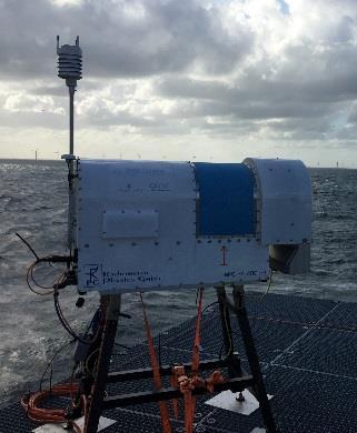
11 HATPRO-R4 passive microwave radiometer Installed on top of container platform Provides vertical profiles of temperature and humidity up to an altitude of at least 1000 m These measurements are combined with the LiDAR wind measurements to obtain information on dynamic stability conditions at FINO1 First time such measurements are performed continuously nearby an offshore wind farm Source: Radiometer Physics GmbH Slide 11 / 25-Jan-16

 and humidity (lower panel) Hovmøller")
12 HATPRO-R4 passive microwave radiometer Example of temperature profiles. Figures showing an example of temperature (upper panel) and humidity (lower panel) Hovmøller diagrams. Slide 12 / 25-Jan-16
 measurement of the 3D wind vector (U,V,W) Provides information about turbulent fluxes at the measurement height The array of USA provides independent information about the")
13 Ultra sonic anemometer (USA) measurements Two additional Gill R3-100 anemometers installed on outward facing booms at 15 and 20 masl FINO1 USA installed at 40, 60 and 80 masl NW site of 100 m mast High frequency (25 Hz) measurement of the 3D wind vector (U,V,W) Provides information about turbulent fluxes at the measurement height The array of USA provides independent information about the vertical wind profile and the turbulence intensity between masl. It also provides information about heat and momentum fluxes which is highly needed for the characterization of the MABL. Together with the ocean equipment, the lowest measurement level (15 m) provides flux measurements for air-sea interaction. Slide 13 / 25-Jan-16
14 Availability of met-data May 2015 June 2015 July 2015 August 2015 September 2015 October 2015 November 2015 December 2015 WLS-34 WLS-37 Radiometer DCF 15 m DCF 20 m December 1 November 1 October 1 September 1 August 1 July 1 June 1 May 1 Slide 14 / 25-Jan-16


15 Oceanographic measurements The overall aim is to gain a better understanding of the interactions between the atmosphere, the ocean and offshore wind farms, such as single turbine and wind farm wake characteristics in the presence of combined wind and wake effects. How does the wind field around offshore wind farms influence the ocean and vice versa? Sullivan et al, 2008 Sullivan et al, 2014 Slide 15 / 25-Jan-16


16 Oceanographic measurements Several moorings deployed in close vicinity to FINO1 and the North-East-corner of Alpha Ventus Moorings equipped with ADCP and ADV which provide current profiles and directional wave properties Mooring M1 equipped with airfoil shear probes and fast response thermistors in order to assess the Reynolds stress M1 M2 / M3 BF Slide 16 / 25-Jan-16

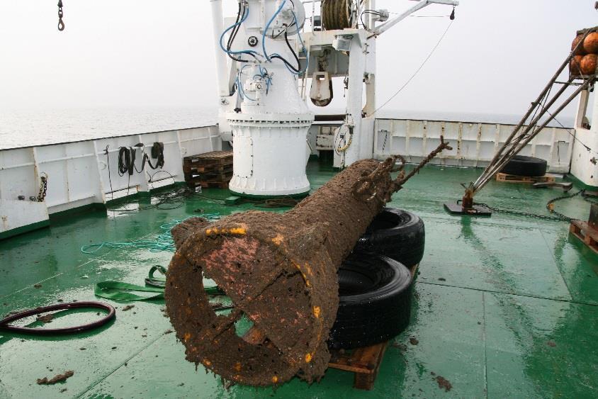
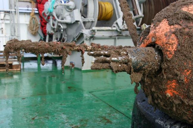

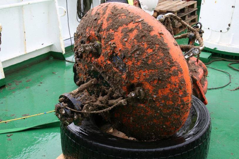
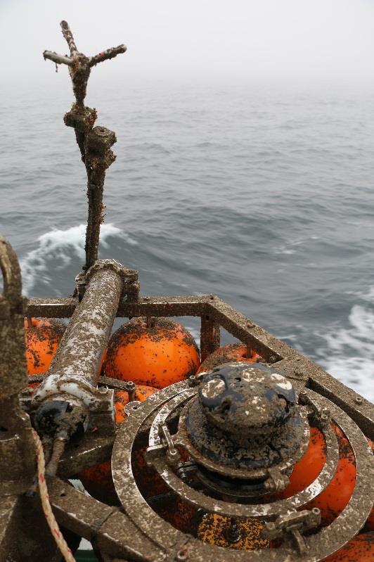
17 Slide 17 / 25-Jan-16 Substantial biofouling after 4 month deployment at FINO1

18 Availability of ocean data M3 BF2ADV BF2ADCP BF1ADCP BF1ADV M1-ADV M1MR M2ADCP 2 Nov 1 Aug 26 July 10 Jun 2 Jun The availability of datasets depends on the quality control criteria which are used. Slide 18 / 25-Jan-16
19 Slide 19 / 25-Jan-16 Thank you for your attention!
20 References Sullivan, P. P., et al. (2008). "Large-eddy simulations and observations of atmospheric marine boundary layers above nonequilibrium surface waves." Journal of the Atmospheric Sciences 65(4): Sullivan, P. P., et al. (2014). "Large-Eddy Simulation of Marine Atmospheric Boundary Layers above a Spectrum of Moving Waves." Journal of the Atmospheric Sciences 71(11): Slide 20 / 25-Jan-16
COTUR Measuring coherence and turbulence with LIDARs
 COTUR Measuring coherence and turbulence with LIDARs Yngve Heggelund, Martin Flügge, Jasna B. Jacobsen, Joachim Reuder, Etienne Cheynet, Benny Svardal, Tom Kjøde Science meets industry 2018-09-13 About
Frequency and evolution of Low Level Jet events over the Southern North Sea analysed from WRF simulations and LiDAR measurements
 Frequency and evolution of Low Level Jet events over the Southern North Sea analysed from WRF simulations and LiDAR measurements David Wagner1, Gerald Steinfeld1, Björn Witha1, Hauke Wurps1, Joachim Reuder2
Jasna Bogunović Jakobsen a a
 Jasna Bogunović Jakobsen a a University of Stavanger Etienne Cheynet a, Jonas Snæbjörnsson a,b, Torben Mikkelsen c, Mikael Sjöholm c, Nikolas Angelou c, Per Hansen c, Jakob Mann c, Benny Svardal d, Valerie
Wave-current-turbulence interaction near the sea surface
 Wave-current-turbulence interaction near the sea surface Mostafa Bakhoday Paskyabi, Ilker Fer, Alastair D. Jenkins Geophysical Institute University of Bergen, Norway Mostafa.Bakhoday@gfi.uib.no Available
Detailed validation of dynamic loading simulation of offshore wind turbines operating in wake
 Detailed validation of dynamic loading simulation of offshore wind turbines operating in wake Juan José Trujillo 1, Hauke Beck 1, Kolja Müller 2, Po Wen Cheng 2, Martin Kühn 1 1 - University of Oldenburg,
FINO Technical and Environmental Research Platforms for the Benefit of the Offshore Industry
 FINO Technical and Environmental Research Platforms for the Benefit of the Offshore Industry Andreas Beeken & Detlef Kindler, 2011-09-07 BALTEXPO, Gdansk 2011 Project Overview FINO Forschung in Nord- und
2D VAR single Doppler lidar vector retrieval and its application in offshore wind energy
 Available online at www.sciencedirect.com ScienceDirect Energy Procedia 137 (2017) 497 504 www.elsevier.com/locate/procedia 14th Deep Sea Offshore Wind R&D Conference, EERA DeepWind'2017, 18-20 January
Remote Wind Measurements Offshore Using Scanning LiDAR Systems
 OWA Report Remote Wind Measurements Offshore Using Scanning LiDAR Systems Offshore Wind Accelerator Wakes 2014 Remote Wind Measurements Offshore Using Scanning LiDAR Systems Lee Cameron lee.cameron@res-group.com
Carbon Trust Offshore Wind Accelerator (OWA) Designing an Offshore Wind Measurement Campaign to Promote the Development of Wake Effects Models
 Designing an Offshore Wind Measurement Campaign to Promote the Development of Wake Effects Models") Carbon Trust Offshore Wind Accelerator (OWA) Designing an Offshore Wind Measurement Campaign to Promote the Development of Wake Effects Models Brian Gribben and Breanne Gellatly 13 June 2012, London 1
Carbon Trust Offshore Wind Accelerator (OWA) Designing an Offshore Wind Measurement Campaign to Promote the Development of Wake Effects Models Brian Gribben and Breanne Gellatly 13 June 2012, London 1
Office of Naval Research Arctic Observing Activities
 Office of Naval Research Arctic Observing Activities Jim Thomson Applied Physics Laboratory, University of Washington jthomson@apl.washington.edu Scott L. Harper, Program Officer, Arctic and Global Prediction
Windcube TM Pulsed lidar wind profiler Overview of more than 2 years of field experience J.P.Cariou, R. Parmentier, M. Boquet, L.
 Windcube TM Pulsed lidar wind profiler Overview of more than 2 years of field experience J.P.Cariou, R. Parmentier, M. Boquet, L.Sauvage 15 th Coherent Laser Radar Conference Toulouse, France 25/06/2009
Assessment of wind conditions at a fjord inlet by complementary use of sonic anemometers and lidars
 Downloaded from orbit.dtu.dk on: Jan 22, 2019 Assessment of wind conditions at a fjord inlet by complementary use of sonic anemometers and lidars Jakobsen, Jasna Bogunovic ; Cheynet, Etienne ; Snæbjörnsson,
Comparison of a Mesoscale Model with FINO Measurements in the German Bight and the Baltic Sea
 Comparison of a Mesoscale Model with FINO Measurements in the German Bight and the Baltic Sea F. Durante; DEWI Italy A. Westerhellweg; DEWI GmbH, Wilhelmshaven B. Jimenez; DEWI GmbH Oldenburg F. Durante
Application of lidars for assessment of wind conditions on a bridge site
 Downloaded from orbit.dtu.dk on: Feb 27, 2019 Application of lidars for assessment of wind conditions on a bridge site Jakobsen, J. B.; Cheynet, Etienne ; Snæbjörnsson, Jonas ; Mikkelsen, Torben Krogh;
WLS70: A NEW COMPACT DOPPLER WIND LIDAR FOR BOUNDARY LAYER DYNAMIC STUDIES.
 WLS70: A NEW COMPACT DOPPLER WIND LIDAR FOR BOUNDARY LAYER DYNAMIC STUDIES. VALIDATION RESULTS AND INTERCOMPARISON IN THE FRAME OF THE 8TH CIMO-WMO CAMPAIGN. S. Lolli 1, L.Sauvage 1, M. Boquet 1, 1 Leosphere,
Reducing Uncertainty of Near-shore wind resource Estimates (RUNE) using wind lidars and mesoscale models
 using wind lidars and mesoscale models") Downloaded from orbit.dtu.dk on: Dec 16, 2018 Reducing Uncertainty of Near-shore wind resource Estimates (RUNE) using wind lidars and mesoscale models Floors, Rogier Ralph; Vasiljevic, Nikola; Lea, Guillaume;
Downloaded from orbit.dtu.dk on: Dec 16, 2018 Reducing Uncertainty of Near-shore wind resource Estimates (RUNE) using wind lidars and mesoscale models Floors, Rogier Ralph; Vasiljevic, Nikola; Lea, Guillaume;
Forecasting the Diabatic Offshore Wind Profile at FINO1 with the WRF Mesoscale Model
 Forecasting the Diabatic Offshore Wind Profile at with the WRF Mesoscale Model D. Muñoz-Esparza; von Karman Institute for Fluid Dynamics, Belgium B. Cañadillas; DEWI GmbH, Wilhelmshaven D. Muñoz-Esparza
Wind Resource Data Summary Cotal Area, Guam Data Summary and Transmittal for December 2011
 Wind Resource Data Summary Cotal Area, Guam Data Summary and Transmittal for December 2011 Prepared for: GHD Inc. 194 Hernan Cortez Avenue 2nd Floor, Ste. 203 Hagatna, Guam 96910 January 2012 DNV Renewables
Boundary Layer Science Challenges in the Context of Wind Energy
 Boundary Layer Science Challenges in the Context of Wind Energy WILLIAM J. SHAW 1 Pacific Northwest National Laboratory National Academies of Sciences, Engineering, and Medicine Workshop on the Future
FOWPI Metocean Workshop Modelling, Design Parameters and Weather Windows
 FOWPI Metocean Workshop Modelling, Design Parameters and Weather Windows Jesper Skourup, Chief Specialist, COWI 1 The Project is funded by The European Union Agenda 1. Metocean Data Requirements 2. Site
Wind Resource Assessment Practical Guidance for Developing A Successful Wind Project
 December 11, 2012 Wind Resource Assessment Practical Guidance for Developing A Successful Wind Project Michael C Brower, PhD Chief Technical Officer Presented at: What We Do AWS Truepower partners with
Air-Sea Interface and Marine Boundary-Layer Anemometers
 LONG-TERM GOALS Air-Sea Interface and Marine Boundary-Layer Anemometers Carl A. Friehe Jesus Ruiz-Plancarte Department of Mechanical and Aerospace Engineering University of California, Irvine Irvine, CA
A Tall Tower Study of the Impact of the Low-Level Jet on Wind Speed and Shear at Turbine Heights
 JP2.11 A Tall Tower Study of the Impact of the Low-Level Jet on Wind Speed and Shear at Turbine Heights Ali Koleiny Keith E. Cooley Neil I. Fox University of Missouri-Columbia, Columbia, Missouri 1. INTRODUCTION
Analysis of Physical Oceanographic Data from Bonne Bay, September 2002 September 2004
 Physics and Physical Oceanography Data Report -1 Analysis of Physical Oceanographic Data from Bonne Bay, September September Clark Richards and Brad deyoung Nov. 9 Department of Physics and Physical Oceanography
WYANDOTTE MUNICIPAL SERVICES COMMUNITY WIND ENERGY PROJECT WIND RESOUCE SUMMARY
 WYANDOTTE MUNICIPAL SERVICES COMMUNITY WIND ENERGY PROJECT WIND RESOUCE SUMMARY MONTHLY REPORT October 15, 2007 Black & Veatch Project: 144374 Prepared by: Black & Veatch Corporation 6300 S. Syracuse Way
Additional Wind and Stability Observations at S6mastaoageroi in Reyoarfiorour Il
 ... ~EfJURSTOFA ~ ISLANDS Report Flosi Hrafn Sig urosson Hreinn Hjartarson Torfi Ka ri Antonsson ~rour Aroson Additional Wind and Stability Observations at Smastaoageroi in Reyoarfiorour Il November 1999
2.1 OBSERVATIONS AND THE PARAMETERISATION OF AIR-SEA FLUXES DURING DIAMET
 2.1 OBSERVATIONS AND THE PARAMETERISATION OF AIR-SEA FLUXES DURING DIAMET Peter A. Cook * and Ian A. Renfrew School of Environmental Sciences, University of East Anglia, Norwich, UK 1. INTRODUCTION 1.1
Measurements and Simulations of Wakes in Onshore Wind Farms Julie K. Lundquist 1,2
 Measurements and Simulations of Wakes in Onshore Wind Farms Julie K. Lundquist 1,2 1 University of Colorado Boulder, 2 National Renewable Energy Laboratory NORCOWE 2016, 14 16 Sept 2016, Bergen, Norway
WIND FARM PERFORMANCE MONITORING WITH ADVANCED WAKE MODELS
 Summary WIND FARM PERFORMANCE MONITORING WITH ADVANCED WAKE MODELS N. Mittelmeier 1, S. Amelsberg 3, T. Blodau 1, A. Brand 4, S. Drueke 2, M. Kühn 2, K. Neumann 1, G. Steinfeld 2 1) REpower Systems SE,
HY-2A Satellite User s Guide
 National Satellite Ocean Application Service 2013-5-16 Document Change Record Revision Date Changed Pages/Paragraphs Edit Description i Contents 1 Introduction to HY-2 Satellite... 1 2 HY-2 satellite data
Wind Flow Modeling The Basis for Resource Assessment and Wind Power Forecasting
 Wind Flow Modeling The Basis for Resource Assessment and Wind Power Forecasting Detlev Heinemann ForWind Center for Wind Energy Research Energy Meteorology Unit, Oldenburg University Contents Model Physics
Energy Resource Group, DIT
 Energy Resource Group, DIT Wind Urchin: An Innovative Approach to Wind Resource Measurement Dr. Derek Kearney 11.05 am E: derek.kearney@dit.ie Introduction Energy Resource Group (ERG) The problem with
Investigating low-level jet wind profiles using two different lidars
 Investigating low-level jet wind profiles using two different lidars B.J. Vanderwende 1 J.K. Lundquist 1,2 1. Atmospheric and Oceanic Sciences University of Colorado Boulder, CO USA 2. National Renewable
Large-eddy simulations of the internal boundary layer and wake flow within large wind farms
 Large-eddy simulations of the internal boundary layer and wake flow within large wind farms Björn Witha G. Steinfeld, D. Heinemann ForWind Center for Wind Energy Research Research Group Energy Meteorology
DBCP National Report Germany. 28 th DBCP Fremantle, 6 st of October 2012 Kai Herklotz (BSH)
") DBCP National Report Germany 28 th DBCP Fremantle, 6 st of October 2012 Kai Herklotz (BSH) Outline BSH and its relation to the DBCP ARGO-Program Other activities MARNET Perspectives 06.10.2012 28th DBCP,
DBCP National Report Germany 28 th DBCP Fremantle, 6 st of October 2012 Kai Herklotz (BSH) Outline BSH and its relation to the DBCP ARGO-Program Other activities MARNET Perspectives 06.10.2012 28th DBCP,
Research within the Coastal Highway Route E39 project. University of Stavanger
 Research within the Coastal Highway Route E39 project University of Stavanger University of Stavanger uis.no Jasna Bogunović Jakobsen 23.10.2017 http://nn.wikipedia.org/wiki/uburen#mediaviewer/file:lysefjordbroen_sett_fra_sokkanuten.jpg
Korean Arctic Research 2015 update
 FARO Annual Meeting, ASSW 2016 Fairbanks, Alaska, 12 March 2016 Korean Arctic Research 2015 update International Cooperation Department Korea Polar Research Institute Outline KOPRI and Korean Arctic research;
Barstad, Idar. Including a wind farm module in WRF what do we gain?. Science Meets Industry; UNI
 2015 Aarnes, Ole Johan. Extremes and Trends in Wave Climate. University of Bergen 2015 (ISBN 978-82-308-2736-9) Aarnes, Ole Johan; Abdalla, Saleh; Bidlot, Jean-Raymond; Breivik, Øyvind. Marine wind and
Generating Virtual Wind Climatologies through the Direct Downscaling of MERRA Reanalysis Data using WindSim
 Generating Virtual Wind Climatologies through the Direct Downscaling of MERRA Reanalysis Data using WindSim WindSim Americas User Meeting December 4 th, 2014 Orlando, FL, USA Christopher G. Nunalee cgnunale@ncsu.edu
Session 4 Presentation: Wave-Current-Surge Information System (WavCIS)
") University of New Orleans ScholarWorks@UNO Ocean Waves Workshop Ocean Waves Workshop 2011 Nov 17th, 3:15 PM - 3:40 PM Session 4 Presentation: Wave-Current-Surge Information System (WavCIS) Chunyan Li Coastal
University of New Orleans ScholarWorks@UNO Ocean Waves Workshop Ocean Waves Workshop 2011 Nov 17th, 3:15 PM - 3:40 PM Session 4 Presentation: Wave-Current-Surge Information System (WavCIS) Chunyan Li Coastal
Met Office and UK University contribution to YMC Ground instrumentation and modelling
 Met Office and UK University contribution to YMC Ground instrumentation and modelling Cathryn Birch 1,2 Adrian Matthews 3, Steve Woolnough 4, John Marsham 2, Douglas Parker 2, Paul Barret 1, Prince Xavier
Influence of sea structures on wind measurements: CFD analysis
 Influence of sea structures on wind measurements: CFD analysis Leonid Vasilyev, Konstantinos Christakos, Brian Hannafious Polytec R&D Institute EERA DeepWind 2015 12 th Deep Sea Offshore Wind R&D Conference,
TAPM Modelling for Wagerup: Phase 1 CSIRO 2004 Page 41
 We now examine the probability (or frequency) distribution of meteorological predictions and the measurements. Figure 12 presents the observed and model probability (expressed as probability density function
Meteorological and Wave Measurements from a Stable Research Platform at Sea
 DISTRIBUTION STATEMENT A. Approved for public release; distribution is unlimited. Meteorological and Wave Measurements from a Stable Research Platform at Sea Tihomir Hristov Department of Mechanical Engineering,
International Arctic Buoy Programme Report
 International Arctic Buoy Programme Report Data Buoy Cooperation Panel 29 Paris, France September 25, 2013 Introduction Some Highlights Increased Russian Collaboration Arctic Observing Experiment Summary
Meteorological Measurements made during RxCADRE
 Meteorological Measurements made during RxCADRE Craig B. Clements, Daisuke Seto, Jon Contezac, and Braniff Davis Fire Weather Research Laboratory Department of Meteorology and Climate Science San José
Dr Marc Lucas CLS Toulouse, France.
 Dr Marc Lucas CLS Toulouse, France. Oceanology International 15th March 2012 Slide 1 Ocean depiction In the past: Information mainly comes from in situ measurements (ADCP) Now: The role of satellite data
National Center for Atmospheric Research Research Applications Laboratory Renewable Energy
 National Center for Atmospheric Research Research Applications Laboratory Renewable Energy Dr. Sue Ellen Haupt, Director & Dr. Branko Kosovic, Program Manager Weather Systems & Assessment Program Research
Near-surface Measurements In Support of Electromagnetic Wave Propagation Study
 DISTRIBUTION STATEMENT A. Approved for public release; distribution is unlimited. Near-surface Measurements In Support of Electromagnetic Wave Propagation Study Qing Wang Meteorology Department, Naval
Oceanic Eddies in the VOCALS Region of the Southeast Pacific Ocean
 Oceanic Eddies in the VOCALS Region of the Southeast Pacific Ocean Outline: Overview of VOCALS Dudley B. Chelton Oregon State University Overview of the oceanographic component of VOCALS Preliminary analysis
Assessment of wind energy for Nevada using towers and mesoscale modeling
 Assessment of wind energy for Nevada using towers and mesoscale modeling Darko Koracin, Richard L. Reinhardt, Marshall B. Liddle, Travis McCord, Domagoj Podnar, and Timothy B. Minor Desert Research Institute,
Validation of KPP in a coastal area
 Validation of KPP in a coastal area By (Météo France/SHOM) and Rémy Baraille (SHOM), Yves Morel (SHOM), Gwenaëlle Hello (Météo France), Hervé Giordani (Météo France) Contents I. Data from MOUTON2007; II.
Radar/Lidar Sensors for Wind & Wake-Vortex Monitoring on Airport: First results of SESAR P XP0 trials campaign at Paris CDG Airport
 www.thalesgroup.com Radar/Lidar Sensors for Wind & Wake-Vortex Monitoring on Airport: First results of SESAR P12.2.2 XP0 trials campaign at Paris CDG Airport F. Barbaresco, Thales Air Systems 2 / Synthesis
Analysis of Near-Surface Oceanic Measurements Obtained During CBLAST-Low
 Analysis of Near-Surface Oceanic Measurements Obtained During CBLAST-Low John H. Trowbridge Woods Hole Oceanographic Institution, MS#12, Woods Hole, MA 02543 phone: (508) 289-2296 fax: (508) 457-2194 email:
Investigation of the Air-Wave-Sea Interaction Modes Using an Airborne Doppler Wind Lidar: Analyses of the HRDL data taken during DYNAMO
 DISTRIBUTION STATEMENT A. Approved for public release; distribution is unlimited. Investigation of the Air-Wave-Sea Interaction Modes Using an Airborne Doppler Wind Lidar: Analyses of the HRDL data taken
Available online at ScienceDirect. Energy Procedia 35 (2013 ) Deep Wind, January 2013, Trondheim, NORWAY
 Deep Wind, January 2013, Trondheim, NORWAY") Available online at www.sciencedirect.com ScienceDirect Energy Procedia 35 (2013 ) 113 120 Deep Wind, 24-25 January 2013, Trondheim, NORWAY Perturbation in the atmospheric acoustic field from a large offshore
Available online at www.sciencedirect.com ScienceDirect Energy Procedia 35 (2013 ) 113 120 Deep Wind, 24-25 January 2013, Trondheim, NORWAY Perturbation in the atmospheric acoustic field from a large offshore
Offshore wind energy is just starting in the United
 Meteorology for Coastal/Offshore Wind Energy in the United States Recommendations and Research Needs for the Next 10 Years by Cristina L. Archer, Brian A. Colle, Luca Delle Monache, Michael J. Dvorak,
RPAS based observation on the Arctic Boundary Layer during the ISOBAR campaigns on Andøya and Hailuoto
 U N I V E R S I T Y O F B E R G E N RPAS based observation on the Arctic Boundary Layer during the ISOBAR campaigns on Andøya and Hailuoto S Kral 1, J Reuder 1, L Båserud 1, G Urbancic 1,M Jonassen 2;1,
Process Study of Oceanic Responses to Typhoons Using Arrays of EM-APEX Floats and Moorings
 DISTRIBUTION STATEMENT A. Approved for public release; distribution is unlimited. Process Study of Oceanic Responses to Typhoons Using Arrays of EM-APEX Floats and Moorings Ren-Chieh Lien Applied Physics
WIND DATA REPORT FOR THE YAKUTAT JULY 2004 APRIL 2005
 WIND DATA REPORT FOR THE YAKUTAT JULY 2004 APRIL 2005 Prepared on July 12, 2005 For Bob Lynette 212 Jamestown Beach Lane Sequim WA 98382 By John Wade Wind Consultant LLC 2575 NE 32 nd Ave Portland OR 97212
Rick Krishfield and John Toole Ice-Tethered Platform Workshop June 29, 2004 Woods Hole Oceanographic Institution
 Ice-tethered Instruments: History and Future Development Rick Krishfield and John Toole Ice-Tethered Platform Workshop June 29, 2004 Woods Hole Oceanographic Institution Since the 1980s, Arctic drifting
Alignment of stress, mean wind, and vertical gradient of the velocity vector
 Downloaded from orbit.dtu.dk on: Sep 14, 218 Alignment of stress, mean wind, and vertical gradient of the velocity vector Berg, Jacob; Mann, Jakob; Patton, E.G. Published in: Extended Abstracts of Presentations
Simulating the Vertical Structure of the Wind with the WRF Model
 Simulating the Vertical Structure of the Wind with the WRF Model Andrea N Hahmann, Caroline Draxl, Alfredo Peña, Jake Badger, Xiaoli Lársen, and Joakim R. Nielsen Wind Energy Division Risø National Laboratory
Evaluation of regional numerical weather prediction model surface fields over the Middle Atlantic Bight
 JOURNAL OF GEOPHYSICAL RESEARCH, VOL. 104, NO. C8, PAGES 18,141 18,158, AUGUST 15, 1999 Evaluation of regional numerical weather prediction model surface fields over the Middle Atlantic Bight Mark F. Baumgartner
Evaluation of a Low cost Drifting Buoy equipped with a Sonic Anemometer
 Evaluation of a Low cost Drifting Buoy equipped with a Sonic Anemometer Chris Marshall Environment Canada National Manager of Marine Monitoring Findings first presented at CMOS Conference, Montreal by
The ECMWF coupled data assimilation system
 The ECMWF coupled data assimilation system Patrick Laloyaux Acknowledgments: Magdalena Balmaseda, Kristian Mogensen, Peter Janssen, Dick Dee August 21, 214 Patrick Laloyaux (ECMWF) CERA August 21, 214
Increasing Transmission Capacities with Dynamic Monitoring Systems
 INL/MIS-11-22167 Increasing Transmission Capacities with Dynamic Monitoring Systems Kurt S. Myers Jake P. Gentle www.inl.gov March 22, 2012 Concurrent Cooling Background Project supported with funding
WIND DATA REPORT. Vinalhaven
 WIND DATA REPORT Vinalhaven July 1, 2004 September 30, 2004 Prepared for Fox Islands Electric Cooperative By Melissa L. Ray Anthony L. Rogers April 4, 2005 Renewable Energy Research Laboratory 160 Governors
A Preliminary Analysis on the Statistics of about One-Year Air Gap Measurement for a Semi-submersible in South China Sea
 Proceedings of the Twenty-sixth (2016) International Ocean and Polar Engineering Conference Rhodes, Greece, June 26-July 1, 2016 Copyright 2016 by the International Society of Offshore and Polar Engineers
Steven Greco* and George D. Emmitt Simpson Weather Associates, Charlottesville, VA. 2. Experiments
 3.3 INVESTIGATION OF FLOWS WITHIN COMPLEX TERRAIN AND ALONG COASTLINES USING AN AIRBORNE DOPPLER WIND LIDAR: OBSERVATIONS AND MODEL COMPARISONS Steven Greco* and George D. Emmitt Simpson Weather Associates,
Update on the AGOR / UAS Scientific Demonstration Integration. Luc Lenain, Ken Melville, Ben Reineman
 Development of Instrumented UAS for Air Sea Interaction Research & Ship-Based UAS Measurements of Air-Sea Interaction and Marine Atmospheric Boundary Layer Processes in the Equatorial Pacific Update on
Opportunities provided by fine-scale meteorological sensor array
 Opportunities provided by fine-scale meteorological sensor array R.M. Randall, C.M Hocut, D.K. Knapp, B.T. MacCall, & J.A. Smith MSA Program Overview Army Challenge Research gaps exist which challenge
Recent improvements on the wave forecasting system of Meteo-France: modeling and assimilation aspects
 Recent improvements on the wave forecasting system of Meteo-France: modeling and assimilation aspects L. Aouf and J-M. Lefèvre Division Marine et Océanographie, Météo-France 13 th International workshop
SCIENTIFIC REPORT. Universität zu Köln, Germany. Institut für Geophysik und Meteorologie, Universität zu Köln, Germany
 SCIENTIFIC REPORT 1 ACTION: ES1303 TOPROF STSM: COST-STSM-ES1303-30520 TOPIC: Boundary layer classification PERIOD: 9-13 November 2015 VENUE: Institut für Geophysik und Meteorologie, Universität zu Köln,
Site Description: Tower Site
 Resource Summary for Fort Collins Site Final Report Colorado Anemometer Loan Program Monitoring Period: /0/00 11/03/007 Report Date: January 1, 00 Site Description: The site is located adjacent to the
Numerical Modelling for Optimization of Wind Farm Turbine Performance
 Numerical Modelling for Optimization of Wind Farm Turbine Performance M. O. Mughal, M.Lynch, F.Yu, B. McGann, F. Jeanneret & J.Sutton Curtin University, Perth, Western Australia 19/05/2015 COOPERATIVE
Synthetic Weather Radar: Offshore Precipitation Capability
 Synthetic Weather Radar: Offshore Precipitation Capability Mark S. Veillette 5 December 2017 Sponsors: Randy Bass, FAA ANG-C6 and Rogan Flowers, FAA AJM-33 DISTRIBUTION STATEMENT A: Approved for public
An Investigation of Turbulent Heat Exchange in the Subtropics
 DISTRIBUTION STATEMENT A. Approved for public release; distribution is unlimited. An Investigation of Turbulent Heat Exchange in the Subtropics James B. Edson University of Connecticut, Avery Point 1080
Deutscher Wetterdienst
 Deutscher Wetterdienst Comparison of wind profiler radar measurements with Doppler wind lidar profiles measurements at the Lindenberg GRUAN site Bernd Stiller, Ronny Leinweber, Volker Lehmann DWD - Deutscher
Evaporation Duct Height Climatology for Norwegian Waters Using Hindcast Data
 Evaporation Duct Height Climatology for Norwegian Waters Using Hindcast Data Petter Østenstad Norwegian Defence Research Establishment (FFI) Horten NORWAY Petter.Ostenstad@ffi.no Marthe Marie Meltzer Norwegian
Arun Platform Tide Gauge
 Arun Platform Tide Gauge Location OS: 506423E 97778N WGS84: Latitude: 50 46 11.39042"N Longitude: 00 29 31.73595"W Instrument Valeport 730 (Druck Pressure Transducer) TGBM Benchmarks Benchmark Description
EPIC2001 was conceived as an intensive process study along and near 95 o W during September and October 2001 used to make measurements of the atmosphe
 EPIC2001 was conceived as an intensive process study along and near 95 o W during September and October 2001 used to make measurements of the atmosphere and ocean in this region. Two aircraft, the National
Reprint 850. Within the Eye of Typhoon Nuri in Hong Kong in C.P. Wong & P.W. Chan
 Reprint 850 Remote Sensing Observations of the Subsidence Zone Within the Eye of Typhoon Nuri in Hong Kong in 2008 C.P. Wong & P.W. Chan 8 th International Symposium on Tropospheric Profiling: Integration
Oceanology International, London, March 2012 Ocean Observation & Forecasting programme. An African Network of Offshore Real-Time Metocean Stations
 Oceanology International, London, March 2012 Ocean Observation & Forecasting programme An African Network of Offshore Real-Time Metocean Stations Valérie QUINIOU-RAMUS, Rémi ESTIVAL (TOTAL S.A., EP/DEV/TEC/GEO)
Understanding oceans in change: Engineering science and technological tools for distributed real-time sensing Kristin Guldbrandsen Frøysa, CMR and
 Understanding oceans in change: Engineering science and technological tools for distributed real-time sensing Kristin Guldbrandsen Frøysa, CMR and University of Bergen Anne A Hageberg, CMR Christian Michelsen
Wind Assessment & Forecasting
 Wind Assessment & Forecasting GCEP Energy Workshop Stanford University April 26, 2004 Mark Ahlstrom CEO, WindLogics Inc. mark@windlogics.com WindLogics Background Founders from supercomputing industry
Detecting wind turbine wakes with nacelle lidars
 Detecting wind turbine wakes with nacelle lidars Dominique Philipp Held 1,2 Jakob Mann 1 Antoine Larvol 2 1 Department of Wind Energy, Technical University of Denmark (DTU) Frederiksborgvej 399 4000 Roskilde,
Lidar observations of marine boundary-layer winds and heights: a preliminary study
 Downloaded from orbit.dtu.dk on: Feb 15, 2018 Lidar observations of marine boundary-layer winds and heights: a preliminary study Pena Diaz, Alfredo; Gryning, Sven-Erik; Floors, Rogier Ralph Published in:
Observational Needs for Polar Atmospheric Science
 Observational Needs for Polar Atmospheric Science John J. Cassano University of Colorado with contributions from: Ed Eloranta, Matthew Lazzara, Julien Nicolas, Ola Persson, Matthew Shupe, and Von Walden
ADVANCED ATMOSPHERIC BOUNDARY LAYER TEMPERATURE PROFILING WITH MTP-5HE MICROWAVE SYSTEM
 ADVANCED ATMOSPHERIC BOUNDARY LAYER TEMPERATURE PROFILING WITH MTP-5HE MICROWAVE SYSTEM E. Kadygrov*, M. Khaikin*, E. Miller*, A. Shaposhnikov*, A. Troitsky** * Central Aerological Observatory, Dolgoprudny,
UK Contribution to YMC Observational Field Campaign
 UK Contribution to YMC Observational Field Campaign Land, air and sea, operational modelling YMC 3 rd Workshop, Malaysia 2017 Paul Barrett paul.barrett@metoffice.gov.uk UK Involvement in YMC HotHouse TerraMaris
1. Introduction/Goals and expected outcomes
 Request for use of the NSF Facilities for Education at the University of Colorado Boulder CABL: Characterizing the Atmospheric Boundary Layer Julie K. Lundquist Dept. of Atmospheric and Oceanic Sciences
Ship-Based UAV Measurements of Air-Sea Interaction in Marine Atmospheric Boundary Layer Processes in the Equatorial Indian Ocean
 DISTRIBUTION STATEMENT A. Approved for public release; distribution is unlimited. Ship-Based UAV Measurements of Air-Sea Interaction in Marine Atmospheric Boundary Layer Processes in the Equatorial Indian
The benefits and developments in ensemble wind forecasting
 The benefits and developments in ensemble wind forecasting Erik Andersson Slide 1 ECMWF European Centre for Medium-Range Weather Forecasts Slide 1 ECMWF s global forecasting system High resolution forecast
Identification of Variables for Site Calibration and Power Curve Assessment in Complex Terrain. SiteParIden
 October 2001 ECN-C--01-102 Identification of Variables for Site Calibration and Power Curve Assessment in Complex Terrain SiteParIden JOR3-CT98-0257 Relative Power Curve Measurements in Complex Terrain
AMVs in the ECMWF system:
 AMVs in the ECMWF system: Overview of the recent operational and research activities Kirsti Salonen and Niels Bormann Slide 1 AMV sample coverage: monitored GOES-15 GOES-13 MET-10 MET-7 MTSAT-2 NOAA-15
Threats to the Power System
 Threats to the Power System Energy Risk and Critical Infrastructure Workshop National Conference of State Legislatures William P. Mahoney III Deputy Director, Research Applications Laboratory National
Subsurface Expressions of Sea Surface Temperature Variability under Low Winds
 Subsurface Expressions of Sea Surface Temperature Variability under Low Winds J. Tom Farrar and Robert A. Weller Woods Hole Oceanographic Institution Chris Zappa Lamont-Doherty Earth Observatory of Columbia
Empirical Z-Visibility Relation Found by Fog Measurements at an Airport by Cloud Radar and Optical Fog Sensors
 14a5 Empirical Z-Visibility Relation Found by Fog Measurements at an Airport by Cloud Radar and Optical Fog Sensors Matthias Bauer-Pfundstein Gerhard Peters Bernd Fischer METEK GmbH, Elmshorn, Germany
Arctic Regional Ocean Observing System Arctic ROOS Report from 2012
 Arctic Regional Ocean Observing System Arctic ROOS Report from 2012 By Stein Sandven Nansen Environmental and Remote Sensing Center (www.arctic-roos.org) Focus in 2012 1. Arctic Marine Forecasting Center