All About Lake-Effect Snow
|
|
|
- Deirdre Todd
- 6 years ago
- Views:
Transcription

1 All About Lake-Effect Snow Tom Niziol Winter Weather Expert The Weather Channel CoCoRaHs Seminar November 12 th, 2015

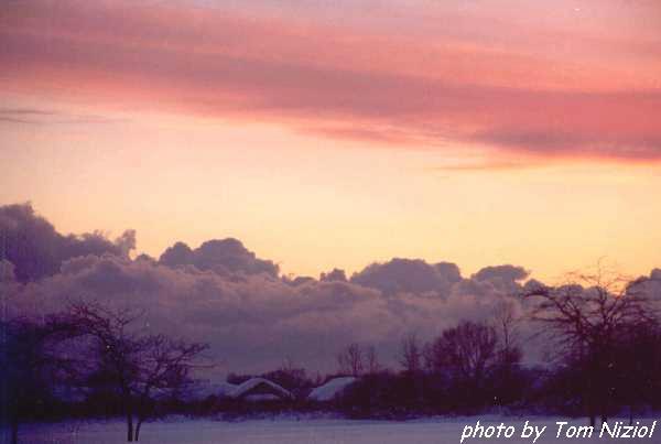
2 Outline Definition of Lake/Ocean Effect Snow (LOES) Favored Locations in North America/World Conceptual Model of LOES Photo by Tom Niziol Lake Effect Snow NWS Buffalo Parking Lot
3 Outline Morphology / Snow Band Classification Fun Look At What Heavy Snow Looks Like Photo by Tom Niziol We lose most of our observers when it snows
4 What Does Lake-Effect Snow Look Like??
5 Lake/Ocean-Effect Snow Occurs when cold air moves over a relatively warm body of water. In most cases, snow develops in post cold frontal conditions typically favoring fair (clear) weather on a synoptic scale.

6 Lake/Ocean-Effect Snow Fair Weather Or Not?? -2 F A 37 F 18 F B
7 Lake/Ocean-Effect Snow Fair Weather Or Not?? A B Barney Wiggin, former MIC at NWS Buffalo, said it best when he claimed that the weather often "clears up stormy" to the lee of the Great Lakes during the winter.
8 Question 1 True or False Does Lake-effect Snow Only Occur In The Great Lakes??? True 12% False 88%

9 Where in North America Does It Occur

10 Where in the World Does It Occur

11 Where in the World Does It Occur
12 Question 2 True or False There Is Such A Thing As Lake-effect Rain True 93% False 7%

13 What Is The Lake-Effect Snow Season Graph by Tom Niziol
14 Seasonality When Does It End??
15 Question 3 Which Great Lake Develops The Most Ice Cover Superior 36% Michigan 0% Huron 7% Erie 39% Ontario 18%

16 Ice Cover On the Great Lakes Lake Huron Lake Ontario Lake Michigan Lake Erie

17 Great Lakes Bathymetry
18 Seasonal Ice Cover On the Great Lakes January 1-7
19 Seasonal Ice Cover On the Great Lakes January 15-21
20 Seasonal Ice Cover On the Great Lakes February 8-14

21 Seasonal Ice Cover On the Great Lakes March 1-7
22 Seasonal Ice Cover On the Great Lakes March 15-21
23 Seasonal Ice Cover On the Great Lakes April 8-14

24 Seasonal Snowfall For The Great Lakes
25 Question 3 What is the highest annual snowfall recorded in one winter season in the Great Lakes Region? % % % 74 4%
26 On What Scale Does LOES Occur? Horizontal scales are Meso-alpha. 12 mi. 120 mi. as defined by Orlanski (1975). Vertical scale Usually confined to < 10,000 ft. Temporal scale Generally on the order of several hours, though multi-day events are not unusual.

")
27 Horizontal Scale Meso-alpha (12mi 120mi) Orlanski (1975).
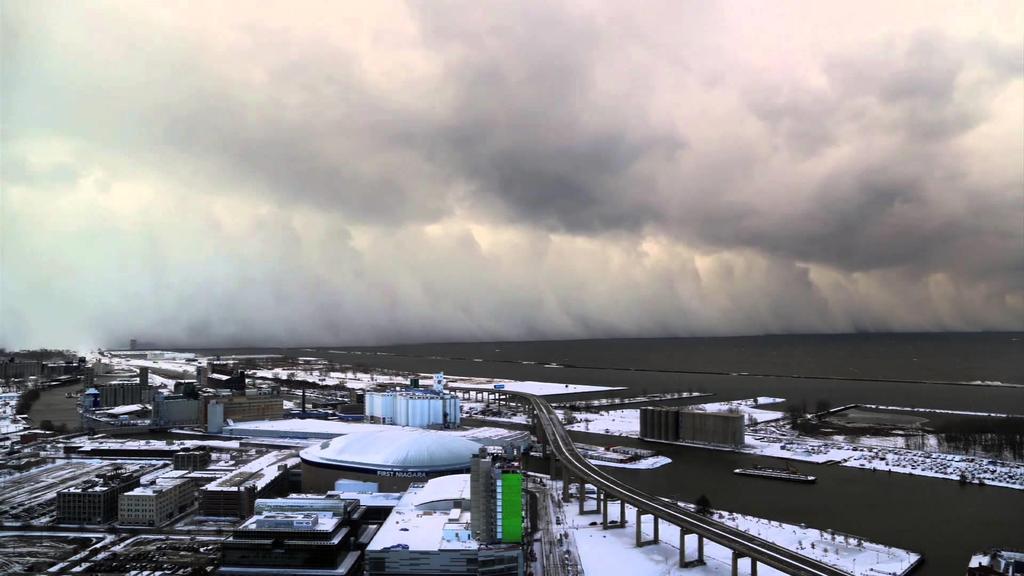
28 North Wall of Lake Effect Snow Band Moving Across the City of Buffalo, NY Off Lake Erie Photo by Gordon Scherer


29 Vertical Scale Lake Effect Convection and its Bigger Summertime Convective Cousin Lake Effect Snow Event Modified Parcel Temp / Dewpoint Lake-Induced CAPE ~300J/kg Summertime Convection Non-modified Temp / Dewpoint CAPE > 2000J/kg

30 Vertical Scale Lake Effect Convection and its Bigger Summertime Convective Cousin This storm produced nearly 70in. of snow over a 3 day period. Lake Effect Snow Event Modifed Parcel Temp / Dewpoint Lake-Induced CAPE ~300J/kg Summertime Convection Non-modified Temp / Dewpoint CAPE > 2000J/kg

31 Temporal Scale Anywhere From a Few Hours to Several Days
 82 (208cm.")
32 Temporal Scale Anywhere From a Few Hours to Several Days 126 (320cm.) 82 (208cm.) 50 miles

33 LOES Meso-Alpha Scale Cold Season Convection Three areas of snowcover downwind of Lake Erie mark this 3-part storm Lake Huron Ontario Lake Ontario New York Lake Erie Ohio Pennsylvania
34 Conceptual Model Lake Snow Formation

35 Cold Air Crossing Warm Water (Disney World Orlando, FL)
")
36 Cold Air Crossing Warm Water (St. Regis Pond Adirondack Park, NY)

37 Conceptual Model Lake Snow Formation Inversion

38 Up Close and Personal With LOES NOAA-16 Satellite Image Aircraft Trajectory

39 The Real Thing Photo by T. Niziol

40 The Real Thing Photo by T. Niziol

41 The Real Thing Photo by T. Niziol

42 The Real Thing Photo by T. Niziol

43 The Real Thing Photo by T. Niziol

44 The Real Thing Photo by T. Niziol

45 Development of Local Instability Modification of Lower Atmospheric Thermodynamic Profile -2 F 37 F 14 F A B
46 Development of Local Instability Modification of Lower Atmospheric Thermodynamic Profile A GRB B APX
47 Development of Local Instability Inversion Hgt 900mb 800mb Air Temp -18C -12C Dewpoint -20C -13C
48 Development of Local Instability Net Change Inversion Hgt +100mb Air Temp +6C Dewpoint +7C
49 Morphology of Snow Bands Attempts to Classify Snow Band Types Horizontal Roll Multiple Banding Single Band Land Breeze Banding Which Factors Are Responsible For So Many Types of Banding? MesoLow Multi-Lake Banding

50 Morphology of Snow Bands Attempts to Classify Snow Band Types Horizontal Roll Multiple Banding Single Band Land Breeze Banding The shape of the water body Orientation of the water body with respect to wind direction MesoLow Wind speed and shear within the mixed layer Multi-Lake Banding
51 Morphology of Snow Bands Multiple Bands Horizontal Roll Convection Horizontal Roll Multiple Banding

52 Morphology of Snow Bands Multiple Band - Horizontal Roll Convection Counter-rotating vortices in the boundary layer. Major axes aligned with the mean boundary layer wind. Significant speed shear and very little directional shear. Wavelength (updraft to updraft) is about three times the height of the Boundary Layer.

53 Morphology of Snow Bands Multiple Bands Horizontal Roll Convection Prevailing BL Wind Atlantic Ocean

54 Morphology of Snow Bands Multiple Bands Horizontal Roll Convection Prevailing BL Wind

55 Multiple Bands Horizontal Rolls Visible Satellite and WSR-88D Composite Reflectivity Prevailing Flow Horizontal roll convection producing multiple bands under prevailing westerly flow across the short fetch of Lake Michigan
56 Multiple Bands - Sea of Japan MSLP Feb 2, z China Japan

57 Multiple Bands - Sea of Japan Visible Satellite

58 Multiple Bands - Sea of Japan Visible Satellite

59 Multiple Bands - Sea of Japan Radar Saporro

60 Multiple Bands - Sea of Japan Tokyo
61 Multiple Bands Gulf of St Lawrence 850mb Height
62 Multiple Bands Gulf of St Lawrence NASA MODIS Polar Orbiter Satellite NASA MODIS 2/7/13

63 NASA MODIS 2/7/13 Multiple Bands Gulf of St Lawrence NASA MODIS Polar Orbiter Satellite

64 Multiple Bands Gulf of St Lawrence NASA MODIS Polar Orbiter Satellite NASA MODIS 2/7/13

65 Multiple Bands Gulf of St Lawrence NASA MODIS Polar Orbiter Satellite NASA MODIS 2/7/13
66 Multiple Bands Cape Cod 850mb Jan 14, z
67 Multiple Bands Cape Cod 850mb Jan 14, z
68 Multiple Bands Cape Cod 925mb Jan 14, z
69 Multiple Bands Cape Cod Jan 14, z 850mb 925mb
70 Multiple Bands Cape Cod Jan 14, z 850mb 925mb -18C -10C -5C -15C 10,000 ft. 7,500 ft. 4,500 ft. 2,000 ft.
71 Multiple Bands Cape Cod MSLP Jan 14, z
72 Multiple Bands Cape Cod MSLP Jan 14, z

73 Multiple Bands Cape Cod KBOX Radar Reflectivity

74 Multiple Bands Cape Cod CHH Sounding 3600ft = 3⁰F 4200ft = 30⁰F Waldstreicher, J.S., 2002: A foot of snow from a 3000-foot cloud: The Ocean-Effect Snowstorm of 14 January Bull. Amer. Meteor. Soc., 83,

75 Morphology of Snow Bands Single Bands Horizontal Roll Multiple Banding Single Band Land Breeze Banding Single Band MesoLow Multi-Lake Banding


76 Morphology of Snowbands Single Band Development Single Band Single Band Lake Huron Lake Ontario
77 Morphology of Snowbands Wide Lake Multiple Rolls Land Breeze Prevailing Wind Cold Warm
78 Morphology of Snowbands Narrow Lake Single Band Land Breeze Prevailing Wind

79 Morphology of Snowbands Thermal Convergence - Single Band Development

80 Morphology of Snowbands Consolidation Into One Band

81 Single Band Development Visible Satellite Imagery Prevailing Flow Note the Single Cloud Band Extending Along the Long Axis of Lake Ontario

82 Single Band Development Visible Satellite and WSR-88D 0.5 Mosaic Radar Reflectivity Radar reflectivity exceeds 35dBz east of Lake Ontario


83 Single Band Development METAR Reports Convergence Zone Pt. Petre NW20G26 kts. Convergence Oswego SW16G32 kts. Surface Reports Over Eastern Lake Ontario Suggest Strong Convergence

84 Wind Parallel Single Dominant Band
85 Wind Parallel Single Dominant Band Lake Effect Storm Dalmation 37 inches in 12 hours

86 January 20, GMT 2100GMT NAM12 Sfc Reflectivity WSR-88D Montague 0.5 Reflectivity

87 January 20, GMT NAM12 Sfc Reflectivity
 NAM12 Photo by Tom Niziol")
88 January 20, GMT NAM12 Cross-Section (Omega and Vertical Circulation) NAM12 Photo by Tom Niziol
89 Multiple Horizontal Rolls vs. Large, Well-developed Single Band
90 Single Band Wind Parallel (Lake Erie Lancaster, NY)

91 North Wall of Lake Effect Snow Band Moving Across the City of Buffalo, NY Off Lake Erie Photo by Gordon Scherer
92 Photo by Tom Niziol Snow Depth After 5-Day Single Band Lake Effect Storm, WFO Buffalo

93 Single Band Development Gulf of Bothnia Parallel to long axis of the body of water
94 Single Band Development Gulf of Bothnia November 1-2, 2006 MSLP 850mb L L L L H L

95 Single Band Development Gulf of Bothnia Parallel to long axis of the body of water

96 Single Band Development Gulf of Bothnia Mosaic Radar Loop
97 Single Band Development Chesapeake Bay 850mb Height
98 Single Band Development Chesapeake Bay 850mb Temperature -9C to -12C

99 Single Band Development Chesapeake Bay Parallel to long axis of the body of water

100 Morphology of Snowbands Thermal Convergence - Land Breeze Snowbands
101 Morphology of Snowbands Land Breeze Snowbands Land Breeze Air Temp: -18 C Water Temp: +3 C Cloudband over Lake Erie that has developed under nearly calm synoptic scale wind and significant air-water temperature differences leading to a well-developed local land breeze circulation.

102 Thermal Convergence

103 Thermal Convergence Under weak NE synoptic flow, the general shape and orientation of the body of water often dictates the type of snowband that develops. Niziol (1995)
104 Thermal Convergence January 8, 1981 Temperatures Air ~ -21C Lake water ~ +3C Lake Michigan MesoLow Under Calm Surface Winds and significant land-lake temperature differences. Niziol (1995)

105 A Spin-off of a Mesolow 2008 NWA Conference - Louisville, KY Sam Lashley National Weather Service Northern Indiana Jon Hitchcock National Weather Service Buffalo, NY

106 Feb 20, 2008

107 20 February, 2008 Radar Mosaic

108 Feb 20, 2008
109 What Does Lake-Effect Snow Look Like??
110
111

112 North Wall Lake-Effect Snow Band Buffalo NY November 2014

113 That s A Lot of Snow

114 Montague Inn Tug Hill East of Lake Ontario

115 Snow Lovers Paradise

116 Who s That Knocking At My Door

117 This Is Gonna Be A Tough Day

118 OK I Am Outside, Now What!!! Photo by Tom Niziol

119 Nothing Like A Cozy Evening Next To The Fire

120
Lake-Effect Research At SUNY Oswego And How We Use it to Prepare Others
 Lake-Effect Research At SUNY Oswego And How We Use it to Prepare Others Presented by: Matthew Seymour, Nicholas Rodick, and Dr. Scott Steiger SUNY Os we go Image: Nicholas Rodick What is Lake -effect Snow?
DETERMINING USEFUL FORECASTING PARAMETERS FOR LAKE-EFFECT SNOW EVENTS ON THE WEST SIDE OF LAKE MICHIGAN
 DETERMINING USEFUL FORECASTING PARAMETERS FOR LAKE-EFFECT SNOW EVENTS ON THE WEST SIDE OF LAKE MICHIGAN Bradley M. Hegyi National Weather Center Research Experiences for Undergraduates University of Oklahoma,
PICTURE OF THE MONTH. Mesoscale Vortices Embedded within a Lake-Effect Shoreline Band
 SEPTEMBER 2004 PICTURE OF THE MONTH 2269 PICTURE OF THE MONTH Mesoscale Vortices Embedded within a Lake-Effect Shoreline Band JOSEPH A. GRIM AND NEIL F. LAIRD * Department of Atmospheric Sciences, University
Chapter 3: Weather Fronts & Storms
 Chapter 3: Weather Fronts & Storms An AIR MASS is a large body of air that has similar characteristics (temperature, humidity) throughout. Air masses can be massively large. Air masses are classified by
Understanding Michigan snowfall. Jim Keysor - NWS Gaylord
 Understanding Michigan snowfall Jim Keysor - NWS Gaylord Presentation Outline Topics Background information on lake effect Radar and lake effect snow Wind direction and lake effect Lake Enhanced snow Elevation
Page 1. Name: 4) State the actual air pressure, in millibars, shown at Miami, Florida on the given weather map.
 State the actual air pressure, in millibars, shown at Miami, Florida on the given weather map.") Name: Questions 1 and 2 refer to the following: A partial station model and meteorological conditions table, as reported by the weather bureau in the city of Oswego, New York, are shown below. 1) Using
Name: Questions 1 and 2 refer to the following: A partial station model and meteorological conditions table, as reported by the weather bureau in the city of Oswego, New York, are shown below. 1) Using
Justin Arnott and Michael Evans NOAA National Weather Service, Binghamton, NY. Richard Grumm NOAA National Weather Service, State College, PA
 3A.5 REGIONAL SCALE ENSEMBLE FORECAST OF THE LAKE EFFECT SNOW EVENT OF 7 FEBRUARY 2007 Justin Arnott and Michael Evans NOAA National Weather Service, Binghamton, NY Richard Grumm NOAA National Weather
High Resolution Modeling of Multi-scale Cloud and Precipitation Systems Using a Cloud-Resolving Model
 Chapter 1 Atmospheric and Oceanic Simulation High Resolution Modeling of Multi-scale Cloud and Precipitation Systems Using a Cloud-Resolving Model Project Representative Kazuhisa Tsuboki Author Kazuhisa
L.O Students will learn about factors that influences the environment
 Name L.O Students will learn about factors that influences the environment Date 1. At the present time, glaciers occur mostly in areas of A) high latitude or high altitude B) low latitude or low altitude
Definitions Weather and Climate Climates of NYS Weather Climate 2012 Characteristics of Climate Regions of NYS NYS s Climates 1.
 Definitions Climates of NYS Prof. Anthony Grande 2012 Weather and Climate Weather the state of the atmosphere at one point in time. The elements of weather are temperature, t air pressure, wind and moisture.
Eastern Shore Weather and Climate. Bill Sammler Warning Coordination Meteorologist National Weather Service Wakefield, VA
 Eastern Shore Weather and Climate Bill Sammler Warning Coordination Meteorologist National Weather Service Wakefield, VA About The NWS The National Weather Service is: A Federal Government Agency Part
Pilots watch the clouds, because clouds can indicate the kind of weather in store for a flight.
 Low stratus Cumulonimbus Pilots watch the clouds, because clouds can indicate the kind of weather in store for a flight. FILL IN THE BLANKS OR CIRCLE ONE: A. Stratus means flat or on one level. Low stratus
Tornadogenesis in Supercells: The Three Main Ingredients. Ted Funk
 Tornadogenesis in Supercells: The Three Main Ingredients Ted Funk NWS Louisville, KY Spring 2002 Environmental Parameters Supercells occur within environments exhibiting several wellknown characteristics
COMET BGMPartners project Z Final report FINAL REPORT
 FINAL REPORT University: Hobart & William Smith Colleges (HWS) Name of University Researcher Preparing Report: Neil Laird NWS Office: Binghamton, NY Name of NWS Researcher Preparing Report: Michael Evans
Climates of NYS. Definitions. Climate Regions of NYS. Storm Tracks. Climate Controls 10/13/2011. Characteristics of NYS s Climates
 Definitions Climates of NYS Prof. Anthony Grande 2011 Weather and Climate Weather the state of the atmosphere at one point in time. The elements of weather are temperature, air pressure, wind and moisture.
SEVERE WEATHER AND FRONTS TAKE HOME QUIZ
 1. Most of the hurricanes that affect the east coast of the United States originally form over the A) warm waters of the Atlantic Ocean in summer B) warm land of the southeastern United States in summer
RR#4 - Multiple Choice
 1. The map below shows the amount of snowfall, in inches, produced by a lake-effect snowstorm in central New York State. The wind that produced this snowfall pattern most likely came from the 1) northeast
Severe Weather with a strong cold front: 2-3 April 2006 By Richard H. Grumm National Weather Service Office State College, PA 16803
 Severe Weather with a strong cold front: 2-3 April 2006 By Richard H. Grumm National Weather Service Office State College, PA 16803 1. INTRODUCTION A strong cold front brought severe weather to much of
1st Annual Southwest Ohio Snow Conference April 8, 2010 Abner F. Johnson, Office of Maintenance - RWIS Coordinator
 1st Annual Southwest Ohio Snow Conference April 8, 2010 Abner F. Johnson, Office of Maintenance - RWIS Coordinator The Ohio Department of Transportation ODOT has approximately 5500 full-time employees
Air Masses, Fronts, Storm Systems, and the Jet Stream
 Air Masses, Fronts, Storm Systems, and the Jet Stream Air Masses When a large bubble of air remains over a specific area of Earth long enough to take on the temperature and humidity characteristics of
Pacific Decadal Oscillation ( PDO ):
:") Time again for my annual Winter Weather Outlook. Here's just a small part of the items I considered this year and how I think they will play out with our winter of 2015-2016. El Nino / La Nina: When looking
Time again for my annual Winter Weather Outlook. Here's just a small part of the items I considered this year and how I think they will play out with our winter of 2015-2016. El Nino / La Nina: When looking
1. Which weather map symbol is associated with extremely low air pressure? A) B) C) D) 2. The diagram below represents a weather instrument.
 B) C) D) 2. The diagram below represents a weather instrument.") 1. Which weather map symbol is associated with extremely low air pressure? 2. The diagram below represents a weather instrument. Which weather variable was this instrument designed to measure? A) air pressure
1. Which weather map symbol is associated with extremely low air pressure? 2. The diagram below represents a weather instrument. Which weather variable was this instrument designed to measure? A) air pressure
Forecast for 6/28-7/31. Forecaster: Matthew Brewer Forecast made at: 12z 6/27/2017
 Forecast for 6/28-7/31 Forecaster: Matthew Brewer Forecast made at: 12z 6/27/2017 Whiteface lodge Mesonet Meteogram for the past 24 hours http://www.nysmesonet.org/data/meteogram#?stid=wfmb Whiteface Summit
Summary of November Central U.S. Winter Storm By Christopher Hedge
 Summary of November 12-13 2010 Central U.S. Winter Storm By Christopher Hedge Event Overview The first significant snowfall of the 2010-2011 season affected portions of the plains and upper Mississippi
Impacts of the April 2013 Mean trough over central North America
 Impacts of the April 2013 Mean trough over central North America By Richard H. Grumm National Weather Service State College, PA Abstract: The mean 500 hpa flow over North America featured a trough over
Goals of Presentation
 Hydrometeorlogical Prediction Center (HPC) Forecast Operations Branch Winter Weather Desk Dan Petersen Dan.Petersen@noaa.gov 301-763-8201 Review HPC winter weather desk forecasts Review winter weather
Why There Is Weather?
 Lecture 6: Weather, Music Of Our Sphere Weather and Climate WEATHER The daily fluctuations in atmospheric conditions. The atmosphere on its own can produce weather. (From Understanding Weather & Climate)
Thanksgiving Snow and Arctic Front 25 November 2005 By Richard H. Grumm National Weather Service State College, PA 16801
 Thanksgiving Snow and Arctic Front 25 November 2005 By Richard H. Grumm National Weather Service State College, PA 16801 1. INTRODUCTION An approaching arctic front brought light snow to most of western
13B.6 STRUCTURE AND CHARACTERISTICS OF LONG LAKE AXIS-PARALLEL LAKE-EFFECT STORMS
 13B.6 STRUCTURE AND CHARACTERISTICS OF LONG LAKE AXIS-PARALLEL LAKE-EFFECT STORMS Scott M. Steiger*, Robert J. Ballentine State University of New York at Oswego, Oswego, New York 1. INTRODUCTION Lake-effect
Extreme Weather and Climate Change: the big picture Alan K. Betts Atmospheric Research Pittsford, VT NESC, Saratoga, NY
 Extreme Weather and Climate Change: the big picture Alan K. Betts Atmospheric Research Pittsford, VT http://alanbetts.com NESC, Saratoga, NY March 10, 2018 Increases in Extreme Weather Last decade: lack
Talking Points for VISIT Lake-effect Snow II session
 Talking Points for VISIT Lake-effect Snow II session 1. Title 2. Objectives 3. Mesoscale model limitations 4. Horizontal Resolution - The delta X rule refers to the width of the feature divided by the
Forecasting Lake-Effect Precipitation in the Great Lakes region using NASA Enhanced Satellite Data
 Forecasting Lake-Effect Precipitation in the Great Lakes region using NASA Enhanced Satellite Data Michelle Cipullo 1, Andrew Molthan 2, Jackie Shafer 2, Gary Jedlovec 2, and Jonathan Case 3 1 North Carolina
Guided Notes Weather. Part 1: Weather Factors Temperature Humidity Air Pressure Winds Station Models
 Guided Notes Weather Part 1: Weather Factors Temperature Humidity Air Pressure Winds Station Models. 1. What is weather? Weather: short-term atmospheric conditions in a specific area at a specific time
Climate. Annual Temperature (Last 30 Years) January Temperature. July Temperature. Average Precipitation (Last 30 Years)
 January Temperature. July Temperature. Average Precipitation (Last 30 Years)") Climate Annual Temperature (Last 30 Years) Average Annual High Temp. (F)70, (C)21 Average Annual Low Temp. (F)43, (C)6 January Temperature Average January High Temp. (F)48, (C)9 Average January Low Temp.
Climate Annual Temperature (Last 30 Years) Average Annual High Temp. (F)70, (C)21 Average Annual Low Temp. (F)43, (C)6 January Temperature Average January High Temp. (F)48, (C)9 Average January Low Temp.
5.0 WHAT IS THE FUTURE ( ) WEATHER EXPECTED TO BE?
 WEATHER EXPECTED TO BE?") 5.0 WHAT IS THE FUTURE (2040-2049) WEATHER EXPECTED TO BE? This chapter presents some illustrative results for one station, Pearson Airport, extracted from the hour-by-hour simulations of the future period
5.0 WHAT IS THE FUTURE (2040-2049) WEATHER EXPECTED TO BE? This chapter presents some illustrative results for one station, Pearson Airport, extracted from the hour-by-hour simulations of the future period
1 What Is Climate? TAKE A LOOK 2. Explain Why do areas near the equator tend to have high temperatures?
 CHAPTER 17 1 What Is Climate? SECTION Climate BEFORE YOU READ After you read this section, you should be able to answer these questions: What is climate? What factors affect climate? How do climates differ
The Integration of WRF Model Forecasts for Mesoscale Convective Systems Interacting with the Mountains of Western North Carolina
 Proceedings of The National Conference On Undergraduate Research (NCUR) 2006 The University of North Carolina at Asheville Asheville, North Carolina April 6-8, 2006 The Integration of WRF Model Forecasts
Weather Practice. 4. As wind velocity decreases, the distance between isobars on a weather map will A) decrease B) increase C) remain the same
 decrease B) increase C) remain the same") 1. The chart below shows the air temperature and the dewpoint temperature near the ground at a given location for four consecutive days. All temperatures were recorded at noon. Which statement is best
1. The chart below shows the air temperature and the dewpoint temperature near the ground at a given location for four consecutive days. All temperatures were recorded at noon. Which statement is best
4. Which map best represents the type of fronts and direction of movement of these fronts in relation to the low-pressure center?
 1. Adjacent water and landmasses are heated by the morning Sun on a clear, calm day. After a few hours, a surface wind develops. Which map best represents this wind's direction? 2. An air pressure of 29.47
Winter. Here s what a weak La Nina usually brings to the nation with tempseraures:
 2017-2018 Winter Time again for my annual Winter Weather Outlook. Here's just a small part of the items I considered this year and how I think they will play out with our winter of 2017-2018. El Nino /
Satellites, Weather and Climate Module 9: Air/sea interactions winter cyclogenesis
 Satellites, Weather and Climate Module 9: Air/sea interactions winter cyclogenesis Winter storms things to consider Deep moisture Thermal discontinuity Favorable surface and upper level features Geographical
Go With the Flow From High to Low Investigating Isobars
 Go With the Flow From High to Low Investigating Isobars Science 10 Mrs. Purba Air Masses The air over a warm surface can be heated, causing it to rise above more dense air. The result is the formation
Cold frontal Rainband and Mid-Atlantic Severe Weather Event 28 September 2006 by Richard H. Grumm And Ron Holmes
 Cold frontal Rainband and Mid-Atlantic Severe Weather Event 28 September 2006 by Richard H. Grumm And Ron Holmes 1. INTRODUCTION A strong cold front moved across central Pennsylvania and the Mid-Atlantic
Detailed Cloud Motions from Satellite Imagery Taken at Thirty Second One and Three Minute Intervals
 Detailed Cloud Motions from Satellite Imagery Taken at Thirty Second One and Three Minute Intervals James F.W. Purdom NOAA/NESDIS/RAMM Branch CIRA Colorado State University W. Laporte Avenue Fort Collins,
A simulation of a lake effect snowstorm with a cloud resolving numerical model
 Click Here for Full Article GEOPHYSICAL RESEARCH LETTERS, VOL. 33,, doi:10.1029/2006gl026638, 2006 A simulation of a lake effect snowstorm with a cloud resolving numerical model Takeshi Maesaka, 1,2 G.
Weather Studies Introduction to Atmospheric Science
 Weather Studies Introduction to Atmospheric Science American Meteorological Society Chapter 1 Monitoring The Weather Credit: This presentation was prepared for AMS by Michael Leach, Professor of Geography
AMDAR Forecast Applications. Richard Mamrosh NWS Green Bay, Wisconsin, USA
 AMDAR Forecast Applications Richard Mamrosh NWS Green Bay, Wisconsin, USA AMDAR has many applications Aviation Low level wind shear Ceilings and visibilities Icing and turbulence Winter Storms Precipitation
Page 1. Name:
 Name: 1) As the difference between the dewpoint temperature and the air temperature decreases, the probability of precipitation increases remains the same decreases 2) Which statement best explains why
Satellites, Weather and Climate Module??: Polar Vortex
 Satellites, Weather and Climate Module??: Polar Vortex SWAC Jan 2014 AKA Circumpolar Vortex Science or Hype? Will there be one this year? Today s objectives Pre and Post exams What is the Polar Vortex
Air Mass Thunderstorms. Air Mass Thunderstorms. Air Mass Thunderstorms. Lecture 26 Air Mass Thunderstorms and Lightning
 Lecture 26 and Lightning Life Cycle Environment Climatology Lightning 1 2 Short-lived, isolated thunderstorms that are not severe are often called air-mass thunderstorms. There are three stages describing
Storm and Storm Systems Related Vocabulary and Definitions. Magnitudes are measured differently for different hazard types:
 Storm and Storm Systems Related Vocabulary and Definitions Magnitude: this is an indication of the scale of an event, often synonymous with intensity or size. In natural systems, magnitude is also related
Observations of Widespread Lake-Effect Cloudiness: Influences of Lake Surface Temperature and Upwind Conditions
 811 Observations of Widespread Lake-Effect Cloudiness: Influences of Lake Surface Temperature and Upwind Conditions DAVID A. R. KRISTOVICH AND NEIL F. LAIRD Illinois State Water Survey, Champaign, Illinois
4/18/2010. National Weather Service. Severe Weather Forecasting: A Western North Carolina Case Study
 National Weather Service Severe Weather Forecasting: A Western North Carolina Case Study Laurence G. Lee Science and Operations Officer National Weather Service Greer, SC Plus 13 River Forecast Centers
1. Base your answer to the following question on the weather map below, which shows a weather system that is affecting part of the United States.
 1. Base your answer to the following question on the weather map below, which shows a weather system that is affecting part of the United States. Which sequence of events forms the clouds associated with
Foundations of Earth Science, 6e Lutgens, Tarbuck, & Tasa
 Foundations of Earth Science, 6e Lutgens, Tarbuck, & Tasa Weather Patterns and Severe Weather Foundations, 6e - Chapter 14 Stan Hatfield Southwestern Illinois College Air masses Characteristics Large body
1 What Is Climate? TAKE A LOOK 2. Explain Why do areas near the equator tend to have high temperatures?
 CHAPTER 17 1 What Is Climate? SECTION Climate BEFORE YOU READ After you read this section, you should be able to answer these questions: What is climate? What factors affect climate? How do climates differ
Hurricanes and Tropical Weather Systems:
 Hurricanes and Tropical Weather Systems: An influence on weather in parts of the USA Meteorology 411 Iowa State University Week 2 Bill Gallus Classification/Terminology Tropical Disturbance enhanced convection
The NASA Short-term Prediction Research and Transition (SPoRT) Center:
 Center:") The NASA Short-term Prediction Research and Transition (SPoRT) Center: Opportunities for Collaboration in the Great Lakes Region Andrew Molthan NASA Marshall Space Flight Center, Huntsville, AL andrew.molthan@nasa.gov
The NASA Short-term Prediction Research and Transition (SPoRT) Center: Opportunities for Collaboration in the Great Lakes Region Andrew Molthan NASA Marshall Space Flight Center, Huntsville, AL andrew.molthan@nasa.gov
Ch. 3: Weather Patterns
 Ch. 3: Weather Patterns Sect. 1: Air Mass & Fronts Sect. 2: Storms Sect. 3: Predicting the Weather Sect. 4: Weather forecasters use advanced technologies Ch. 3 Weather Fronts and Storms Objective(s) 7.E.1.3
The Earth System - Atmosphere III Convection
 The Earth System - Atmosphere III Convection Thunderstorms 1. A thunderstorm is a storm that produces lightning (and therefore thunder) 2. Thunderstorms frequently produce gusty winds, heavy rain, and
Final Report. University Researchers Preparing Report: David Kristovich and Neil Laird
 Final Report University: The University of Illinois in Urbana-Champaign University Researchers Preparing Report: David Kristovich and Neil Laird NWS Office: National Weather Service Forecast Office in
Forecasting Polar Lows. Gunnar Noer The Norwegian Meteorological Institute in Tromsø
 Forecasting Polar Lows Gunnar Noer The Norwegian Meteorological Institute in Tromsø Longyearbyen Hopen Bear Island Jan Mayen Tromsø Gunnar Noer Senior forecaster / developer for polar meteorology The Norwegian
The 2015 NWS Spring and Summer Weather Update
 http://weather.gov The 2015 NWS Spring and Summer Weather Update Western North Carolina severe weather climatology Tony Sturey, WCM Greenville/Spartanburg, SC North Carolina Spring and Summer Outlooks
Global Weather Trade Winds etc.notebook February 17, 2017
 Global Weather 1 north pole northern hemisphere equator southern hemisphere south pole 2 We have seasons because of the Earth's tilt The seasons are opposite in the northern and southern hemispheres winter
Winter Weather. National Weather Service Buffalo, NY
 Winter Weather National Weather Service Buffalo, NY Average Seasonal Snowfall SNOWFALL = BIG IMPACTS School / government / business closures Airport shutdowns/delays Traffic accidents with injuries/fatalities
THE INFLUENCE OF THE GREAT LAKES ON NORTHWEST SNOWFALL IN THE SOUTHERN APPALACHIANS
 P2.18 THE INFLUENCE OF THE GREAT LAKES ON NORTHWEST SNOWFALL IN THE SOUTHERN APPALACHIANS Robbie Munroe* and Doug K. Miller University of North Carolina at Asheville, Asheville, North Carolina B. Holloway
National Weather Service-Pennsylvania State University Weather Events
 National Weather Service-Pennsylvania State University Weather Events Historic Ohio Valley January Severe weather and Tornado Event by Richard H. Grumm National Weather Service State College PA 16803 and
Moisture, Clouds, and Precipitation: Clouds and Precipitation. Dr. Michael J Passow
 Moisture, Clouds, and Precipitation: Clouds and Precipitation Dr. Michael J Passow What Processes Lift Air? Clouds require three things: water vapor, a condensation nucleus, and cooling Cooling usually
Chapter 7 Properties of the Atmosphere
 14. Day Breezes H L Chapter 7 Properties of the Atmosphere Questions Pages 177 179 1. (3) 2. (4) 3. (4) 4. (3) 5. (2) 6. (3) 7. (2) 8. (2) 9. (3) 10. (1) 11. (4) 12. (2) Questions Pages 186 188 13. (3)
SCI-4 Mil-Brock-Weather Exam not valid for Paper Pencil Test Sessions
 SCI-4 Mil-Brock-Weather Exam not valid for Paper Pencil Test Sessions [Exam ID:1TLR5H 1 Warm air rises and cools. Moisture in the air forms clouds that will bring rain. What pressure system is described?
Space Atmospheric Gases. the two most common gases; found throughout all the layers a form of oxygen found in the stratosphere
 Earth s atmospheric layers Earth s atmosphere is the layer of gases that surrounds the planet and makes conditions on Earth suitable for living things. Layers Earth s atmosphere is divided into several
Middle-Latitude Cyclone
 Middle-Latitude Cyclone What is a mid-latitude cyclone? - The mid-latitude cyclone is a synoptic scale low pressure system that has cyclonic (counter-clockwise in northern hemisphere) flow that is found
How strong does wind have to be to topple a garbage can?
 How strong does wind have to be to topple a garbage can? Imagine winds powerful enough to pick up a truck and toss it the length of a football field. Winds of this extreme sometimes happen in a tornado.
III. Section 3.3 Vertical air motion can cause severe storms
 III. Section 3.3 Vertical air motion can cause severe storms http://www.youtube.com/watch?v=nxwbr60tflg&feature=relmfu A. Thunderstorms form from rising moist air Electrical charges build up near the tops
Deep Cyclone and rapid moving severe weather event of 5-6 June 2010 By Richard H. Grumm National Weather Service Office State College, PA 16803
 Deep Cyclone and rapid moving severe weather event of 5-6 June 2010 By Richard H. Grumm National Weather Service Office State College, PA 16803 1. INTRODUCTION A rapidly deepening surface cyclone raced
Winter Storm of 15 December 2005 By Richard H. Grumm National Weather Service Office State College, PA 16803
 Winter Storm of 15 December 2005 By Richard H. Grumm National Weather Service Office State College, PA 16803 1. INTRODUCTION A complex winter storm brought snow, sleet, and freezing rain to central Pennsylvania.
Name: Regents Earth Science. Weather and Climate - Review Questions
 Name: Regents Earth Science Weather and Climate - Review Questions Date: Thayer - 279 1. People sometimes release substances into the atmosphere to increase the probability of rain by A) raising the air
Contents. Section 1: Climate Factors. Section 2: Climate Types. Section 3: Climate Effects
 Contents Section 1: Climate Factors 1. Weather or Climate?.... 2 2. Elements of Climate.... 4 3. Factors Affecting Climate.... 10 4. Comparing Climates.... 15 5. Quiz 1.... 20 Section 2: Climate Types
Shawn M. Milrad Atmospheric Science Program Department of Geography University of Kansas Lawrence, Kansas
 Shawn M. Milrad Atmospheric Science Program Department of Geography University of Kansas Lawrence, Kansas Eyad H. Atallah and John R. Gyakum Department of Atmospheric and Oceanic Sciences McGill University
A Re-examination of the Lost Lake Effect in Buffalo, New York
 A Re-examination of the Lost Lake Effect in Buffalo, New York Stephen Vermette and Emmanuel Orengo Department of Geography and Planning Buffalo State College Buffalo, NY 1 E-mail: vermetsj@buffalostate.edu
Climate.tgt, Version: 1 1
 Name: Key Concepts Choose the letter of the best answer. (5 points each) 1. 2. 3. 4. 5. 6. 7. 8. 9. 10. Date: A city located in the middle of North America experiences extreme temperature changes during
Great Lakes Update. Volume 199: 2017 Annual Summary. Background
 Great Lakes Update Volume 199: 2017 Annual Summary Background The U.S. Army Corps of Engineers (USACE) tracks and forecasts the water levels of each of the Great Lakes. This report is primarily focused
Appalachian Lee Troughs and their Association with Severe Thunderstorms
 Appalachian Lee Troughs and their Association with Severe Thunderstorms Daniel B. Thompson, Lance F. Bosart and Daniel Keyser Department of Atmospheric and Environmental Sciences University at Albany/SUNY,
Weather Notes. Chapter 16, 17, & 18
 Weather Notes Chapter 16, 17, & 18 Weather Weather is the condition of the Earth s atmosphere at a particular place and time Weather It is the movement of energy through the atmosphere Energy comes from
2. Can you describe how temperature and dissolved solids changes the density of water?
 Unit 4: Oceanography LT 4.1 Density: I can explain the role density plays to help form some currents. #1 Yes I can: 1. Can you explain what density is and how you calculate it? 2. Can you describe how
Great Lakes Update. Volume 191: 2014 January through June Summary. Vol. 191 Great Lakes Update August 2014
 Great Lakes Update Volume 191: 2014 January through June Summary The U.S. Army Corps of Engineers (USACE) monitors the water levels of each of the Great Lakes. This report provides a summary of the Great
Case Study: Severe Thunderstorm Over Fairbanks, AK on 8 th of June, 1997
 Case Study: Severe Thunderstorm Over Fairbanks, AK on 8 th of June, 1997 Michael Richmond NWS - WFO Fairbanks 23 August, 2007 Introduction: Thunderstorms are a prominent feature of the Alaska Interior
The hydrologic service area (HSA) for this office covers Central Kentucky and South Central Indiana.
 for this office covers Central Kentucky and South Central Indiana.") NWS Form E-5 (04-2006) NATIONAL OCEANIC AND ATMOSPHERIC ADMINISTRATION (PRES. BY NWS Instruction 10-924) NATIONAL WEATHER SERVICE MONTHLY REPORT OF HYDROLOGIC CONDITIONS HYDROLOGIC SERVICE AREA (HSA) Louisville
NWS Form E-5 (04-2006) NATIONAL OCEANIC AND ATMOSPHERIC ADMINISTRATION (PRES. BY NWS Instruction 10-924) NATIONAL WEATHER SERVICE MONTHLY REPORT OF HYDROLOGIC CONDITIONS HYDROLOGIC SERVICE AREA (HSA) Louisville
Heavy Rainfall Event of June 2013
 Heavy Rainfall Event of 10-11 June 2013 By Richard H. Grumm National Weather Service State College, PA 1. Overview A 500 hpa short-wave moved over the eastern United States (Fig. 1) brought a surge of
Low-end derecho of 19 August 2017
 Low-end derecho of 19 August 2017 By Richard H. Grumm and Charles Ross National Weather Service State College, PA 1. Overview A cluster of thunderstorms developed in eastern Ohio around 1800 UTC on 19
An overview of Wet Season Forecasting in the Northern Territory
 TWP-ICE Meeting November 2004 An overview of Wet Season Forecasting in the Northern Territory Lori Chappel Northern Territory Regional Forecasting Centre Australian Government Bureau of Meteorology Day
A Comparison of Mid-Level Frontogenesis to Radar- Indicated Heavy Snowbands
 A Comparison of Mid-Level Frontogenesis to Radar- Indicated Heavy Snowbands Christopher D. Karstens Iowa State University Mentor: Dr. William A. Gallus, Jr. Iowa State University Overview Background Motivation
Science 1206 Chapter 1 - Inquiring about Weather
 Science 1206 Chapter 1 - Inquiring about Weather 1.1 - The Atmosphere: Energy Transfer and Properties (pp. 10-25) Weather and the Atmosphere weather the physical conditions of the atmosphere at a specific
Storms. Tropical Cyclone?
 Storms Tropical Cyclone? Tropical Cyclone: low pressure storm forming in the tropics (Start as Thunder Storms). They form around a center, producing heavy winds and rains. Storms What strengthens a Tropical
Model Simulations Examining the Relationship of Lake-Effect Morphology to Lake Shape, Wind Direction, and Wind Speed
 2102 MOTHLY EATHER REVIE VOLUME 131 Model Simulations Examining the Relationship of Lake-Effect Morphology to Lake Shape, ind Direction, and ind Speed EIL F. LAIRD AD JOH E. ALSH Department of Atmospheric
Section 13-1: Thunderstorms
 Section 13-1: Thunderstorms Chapter 13 Main Idea: The intensity and duration of thunderstorms depend on the local conditions that create them. Air-mass thunderstorm Mountain thunderstorm Sea-breeze thunderstorm
DEPARTMENT OF EARTH & CLIMATE SCIENCES Name SAN FRANCISCO STATE UNIVERSITY Nov 29, ERTH 360 Test #2 200 pts
 DEPARTMENT OF EARTH & CLIMATE SCIENCES Name SAN FRANCISCO STATE UNIVERSITY Nov 29, 2018 ERTH 360 Test #2 200 pts Each question is worth 4 points. Indicate your BEST CHOICE for each question on the Scantron
Test Form: A Key Final Exam: Spring 2011
 Test Form: A Key Final Exam: Spring 2011 Instructions: Write your name (last name and first name) on your bubble sheet. Write your student identification number on the bubble sheet, and carefully and completely
WEEKEND WEATHER OUTLOOK BELIZE, CENTRAL AMERICA
 WEEKEND WEATHER OUTLOOK BELIZE, CENTRAL AMERICA PERIOD: Friday, July 13 until Monday, July 16, 2012 DATE ISSUED: Friday, June 13, 2012, 9:00 am RFrutos SYNOPSIS: A weak pressure gradient over the NW Caribbean
Tuesday, September 13, 16
 Weather Weather State Objectives 4.c, 4.d, 4.h. Discussion What are some ways in which weather affects your everyday life? Discussion What are some ways in which weather affects your everyday life? What