St. Louis District Mobility
|
|
|
- Whitney George
- 6 years ago
- Views:
Transcription

 in both directions Average incident Lane clearance decreased significantly Poplar Street Bridge Interchange reconstruction")
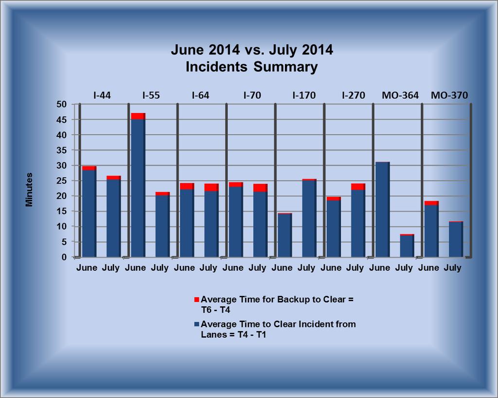
1 St. Louis District Mobility July 2014 GuidePost Freeway mobility Improved overall compared to June consistent with the just over 1% decrease in the average 24 hour volume Freeway Volumes leveled off for the year after peaking last month but Still remain higher than last year by over 3% Arterial travel times remained fairly steady with some minor improvements along NB Route 141 in the PM and in the SB direction between I-64 and I-44 US 67 in the NB AM improved between I-64 and Mo 340 but declined in the SB AM between I- 44 and Mo 30. PM mobility remains low between I-70 and Route AC (New halls Ferry Road) in both directions Average incident Lane clearance decreased significantly Poplar Street Bridge Interchange reconstruction began in July, which will eventually improve mobility near the PSB. Mobility Snapshot Freeway Mobility Minor Improvements in Both AM and PM Freeway Average 24 hour Volumes July 2013 July 2014 Increase of 3.6 % Major Incidents June 2014: 7 July 2014: Avg Avg. 5.4 ZONING IN TMS Work Zones July 2013: 358 July 2014: 479 Work Zone breakdown: Major: 4 1.2% Moderate: 1 0.4% Minor: % Work zone crashes: 6 Average Incident Duration June July Lane Clearance: 25:35 21:51 Incident Clearance: 26:24 22:01 (Min: sec) Major Impact Work Zones June 4 July 4 Moderate Impact Work Zones June 0 July 1 Year to Year Mobility Comparison: July 2013 July 2014 Major impact WZ: Increased Moderate impact WZ: Increased Major incidents: Improved Freeway Mobility: Improved Trending UP Gateway Guide Transportation Management Center
2 Work Zones TMC Observed Work Zones July 2014 Level of Travel Time Impact Number of Work Zones Major Impact 4 Moderate Impact 1 Minor Impact 310 Total 315 *Impact Levels described in Data Key SL District Inspections: Jun 2014: 25% Jul 2014: 31% Goal: 50% SL Mobility Rating: Jun 2014: 94% Jul 2014: 97% Goal: 91% Visibility levels: Jun 2014: 87% Jul 2014: 84% Goal: 91% Major Impact (15 Minutes or Above Additional Travel Time 7/11 (Friday) PM Eastbound I-44 from Memorial Drive to Washington Avenue Full Closure Full closure for Park Over the Highway work 18 minutes additional travel time experienced All mitigation efforts were in full use 7/12 (Saturday) AM Eastbound I-44 from Memorial Drive to Washington Avenue Full Closure Full closure for Park Over the Highway work 30 minutes additional travel time experienced All mitigation efforts were in full use 7/12 (Saturday) PM Eastbound I-64 at Kingshighway Two Left Lanes Closed Paving operation with lane shifts 18 minutes additional travel time experienced for initial setup All mitigation efforts were in full use 7/19 (Saturday) PM Eastbound I-64 at Kingshighway Two Left Lanes Closed Paving operation with lane shifts 18 minutes additional travel time experienced for initial setup All mitigation efforts were in full use Moderate Impact (10-14 Minutes Additional Travel Time) 7/31 (Thursday) PM Eastbound I-64 at Kingshighway Two Left Lanes Closed Paving operation with lane shifts 10 minutes additional travel time experienced for initial setup All mitigation efforts were in full use 2
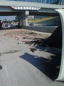
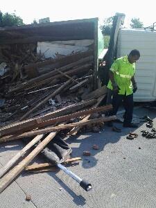
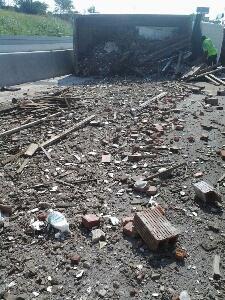
3 Work Zones Work Zone Related Crashes With Mobility Impact 7/2 (Wednesday) AM Eastbound I-64 at Boone Bridge Two Right Lanes Closed A single vehicle rollover crash during morning rush 45 minutes of additional travel time experienced All work zone temporary traffic control was in place 7/7 (Monday) AM Eastbound I-64 before Vandeventer Avenue All Lanes Open Overturned contractor dump truck Caused debris to scatter over all four driving lanes 6.5 mile queue to Big Bend Boulevard All work zone temporary traffic control was in place Note: There was also one TMA Hit on July 25, It was clipped by a Tractor Trailer with no injuries. All vehicles were driven from scene with no impact on mobility. 3


4 Work Zones 4

5 Incident Management 5

 (1) Number of Fatal Incidents June 2014 vs. July 2014 (2) (0) Number of Tractor Trailer Incidents June 2014 vs.")
6 May June July Incident Management July 2014 Incidents Map EB I-64 before Vandeventer Avenue Legend Incidents Crashes Number of Incidents Number of Incidents Denotes Location of Major Impact Traffic Incidents Interstate I I I I I I Mo Mo Total Number of Major Impact Incidents June 2014 vs. July 2014 (7) (1) Number of Fatal Incidents June 2014 vs. July 2014 (2) (0) Number of Tractor Trailer Incidents June 2014 vs. July 2014 (40) (27) 6


7 Incident Management Major Impact Traffic Incidents and Mitigation 7/7/2014 (Monday) Time: 8:41 am 12:16 pm Location: St. Louis City Eastbound I-64 before Vandeventer Avenue Event: Two vehicle crash involving a contractor dump truck that spilled its load Estimated Initial Impact: A contractor dump truck carrying bricks, lumber and assorted materials overturned during the crash spilling cargo across traffic lanes. 4 of 4 travel lanes affected. Action: MoDOT Emergency Responders and MoDOT maintenance crews set up a work zone and Motorist Assist and Maintenance crews stabilized the travel lanes. A Bobcat was used to remove spilled cargo and a tow crane used to upright the tractor trailer. St. Louis City Police and EMS responded to the scene assisting with traffic control and treating the two injured. TMC posted incident notifications on highway boards in advance of the incident and posted a notification on the traveler information map. MoDOT s Work Zone Coordinator was notified along with Community Relations who contacted and informed the media. Result: All eastbound lanes were closed. Traffic was moving on the right shoulder with a queue to Big Bend Boulevard. Traffic returned to normal flow 12 minutes after the incident cleared. Event Duration: 3 hours 35 minutes Eastbound I-64 before Vandeventer Avenue Left Shoulder Lane 1 Lane 2 Lane 3 Lane 4 Right Shoulder Closed 3:23 3:23 3:23 3:23 2:27 0:04 7


8 Incident Management 8

9 Freeway Management D AM Peak Changes in July 2014 B C D Mobility Improved A Mobility Declined *All weekdays are included in speed index calculation 9
10 Freeway Management 9 12 W/O Woodlawn Big Bend Road Big Bend 3 Road 6 10

11 Freeway Management 9 12 Maryville Centre 3 6 Maryville Centre 9 12 W/O Hampton Ave


12 Freeway Management PM Peak Changes in July 2014 A B C Mobility Improved *All weekdays are included in speed index calculation 12


13 Freeway Management 9 12 Lindbergh Blvd MO


14 Freeway Management 9 12 Maryville Centre

15 Freeway Management Readings from every detector on the interstates in the St. Louis District are used for this comparison. An average 24 hour volume value is determined for each route and direction per month. The average values are then combined for a total 24 hour volume. The values presented represent the number of vehicles on the district s interstates on the average weekday for each month. 15
16 Arterial Management New Arterial Travel Time Index This is the fifth month attempting to report arterial travel times in a similar format to freeways. Data from MO Route 141 and US Route 67 are presented for in both the AM/PM peak for North and Southbound directions. An explanation of how this effort is being completed is included in the following paragraphs. Arterial mobility is measured by a travel time index, or TTI. The TTI for a segment of roadway over a peak period is calculated by dividing the average travel time by the expected travel time. The expected travel time is simply the length of the segment divided by the posted speed limit. Due to signalization of arterials, determining a true free flow speed is not practical. For this reason, the posted speed limit is used rather than the free flow speed. A value greater than 1.0 means the average travel time during the peak period is longer than the expected. Because arterial travel times are measured over a segment rather than at a point, the TTI charts display one index value for the entire segment. This means the TTI will be displayed as a straight line between measurement points rather than as a slope from one line to the next as shown on the freeway charts. The travel time indices being presented are the current month and the previous month. A comparison of the previous year will be added as soon as the information is available for analysis. Arterial mobility on MO Route 141 was introduced first, with US Route 67 the second of several instrumented arterial routes to be added in the future. Eventually, as more routes are added to the report, the arterial travel time index will be displayed on a color coded map similar to the freeway mobility map. MO Route 141 US Route 67 16

17 Arterial Management 17
18 Arterial Management 18
19 Arterial Management 19

20 Arterial Management 20


21 Arterial Management 7/1 (Tuesday) Location: Southbound I-170 ramp to Westbound MO 180 Event: Vehicle drove off of road into tree and shut ramp down Time: 8:55 am 10:17 am Total Time: 1 hour 22 minutes Action: Signal at MO I-170 was set to free to flush the traffic through. After the truck was removed from the ditch, signal was set back to normal operation Result: The adjustment moved traffic efficiently with no backups on either approach. Vehicles were making illegal right turns from left turn lanes (but yielding to opposing left turn movement). 21
22 Arterial Management Fair St. Louis Events The City of St. Louis, St. Louis Metro Police Department, MoDOT, Forest Park Forever, Fair St. Louis and Metro personnel met for several months to prepare for the July Fair St. Louis Events in Forest Park. The group worked on a plan to mitigate traffic issues for the event including the interstates, major and minor arterials and parking facilities. The city and MoDOT worked together on coordinating signals along multiple corridors affecting ingress and egress over the three day event. The egress coordination plan was implemented for testing Saturday morning June 28 th at 5:30 a.m. The implementation went well with a few fine-tuning adjustments that needed to be made. A traffic mitigation plan was also implemented that covered the event dates and times from the open of the fair to the closing on July 5 th with the fireworks. Thursday July 3 rd events: The lane drop that was supposed to be on Forest Park Parkway (FPP) was incorrectly set up on Skinker instead of FPP and the responsible traffic control company responded an hour later to correct the lane drop issue. As a result, Skinker northbound traffic became congested and the AM plan (2/4/1) was implemented to relieve congestion. The NB left turns on Kingshighway at Barnes Hospital and West Pine were eliminated at 3:00 p.m. to limit access into the park and to improve traffic progression on the corridor. Planned WB I-64 ramp closures at Hampton and Clayton/Skinker for the event were implemented between 3:30 p.m. and 4:30 p.m., at which time the SB left turn from Skinker to I-64 was eliminated to coincide with the on-ramp closure. The traffic on Kingshighway and Skinker/McCausland was heavy between the hours of 3:30-5:30 p.m., which construed Thursday s PM rush. As the PM rush was winding down, the signals at Kingshighway, Hampton, and Skinker/Clayton were placed on the AM plan (2/4/1) to accommodate access into the park. The signals at Kingshighway, Hampton, and Skinker/Clayton were switched over at 7:00 p.m. for the PM plan (3/4/1) as traffic patterns switched from peak entry into the park to beginning to exit the park. The signals on Lindell were switched over at 7:42 p.m. to the PM plan (3/1/1) (the normal plan was used vs. the egress plan due to the planned lane drop not being deployed on WB I-64). The entry plan for I-44 WB off ramp at Vandeventer was scaled back due to the lack of ramp traffic that was anticipated and the traffic queues on Vandeventer. The fireworks ended at 10:18 p.m. and the exit from the park started. At 10:56 p.m. the signals at Hampton and Skinker were switched to the exit plan (3/2/1) as traffic made it to the park exits to these arterials. Full egress from the park completed at 11:22 p.m. and the egress traffic off of the arterial was done at 11:45 p.m. and AM plan (2/4/1) was implemented for Kingshighway, Hampton, and Skinker/Clayton for Friday s events. 22
23 Arterial Management Friday July 4 th Events: The command center opened at 08:40 a.m. and all city cameras started the day down due to a power outage at Soldiers Memorial that caused the camera outage. The North/South arterials were already running AM plan (2/4/1). The city camera system was back online and running at 10:00 a.m. The McCausland/Skinker arterial had a large queue exiting from the parade at 12:02 p.m. therefore the arterial was placed on PM plan (3/4/1). The inbound fair rush began at 7:26 p.m. The North/ South arterials were placed on AM plan (2/4/1), which was able to hand the traffic volumes entering the fair. There was a gas main break discovered at 7:38 p.m. on SB West Park where one SB lane was temporarily closed until the work could be postponed until overnight. The McClausland/Skinker arterial was placed on exit plan (3/2/1) due to heavy pedestrian traffic at Forsyth at 9:11 p.m. The Kingshighway, Hampton and Forest Park Parkway arterials were placed on exit plan (3/2/1) between 9:58 & 10:38 p.m. The fireworks show was on from 9:57 p.m. to 10:16 p.m. The Skinker/McClausland arterial egress was completed at 11:15 p.m. After the main park egress, the Hampton arterial was placed on PM plan (3/4/1) to give more time to the NBL onto I-64 and less delay for Oakland since the exiting traffic pattern switched from exiting the park to exiting via Oakland. Full egress was completed at 11:39 p.m. and the North/South arterials were set to the AM plan (2/4/1). Saturday July 5 th Events: The third day of the fair opened to the public at 12:00 p.m., at which time there was a heavy volume of pedestrian traffic using the Hampton interchange, Lindell and Forsyth/Lagoon where adjustments were made to accommodate the influx of pedestrians accessing the park via Metrolink. The volume of traffic increased on the North/South arterials for fair entrance and the AM plan signal timing was handling the traffic. The Kingshighway, Hampton and Forest Park Parkway arterials were placed on exit plan (3/2/1) between 10:00 & 10:40 p.m. The fireworks show was from 10:00 p.m. to 10:21 p.m. The Skinker/McClausland arterial egress was completed at 11:30 p.m.. After the park egress, the Hampton arterial was placed on PM plan (3/4/1) to give more time to the NBL onto I-64 and less delay to Oakland again. Full egress was completed by 11:30 p.m. Conclusion: The communication and cooperation between all agencies was highly effective in correcting glitches and mitigating potential traffic related events during the Fair. The close coordination by all involved helped traffic ingress and egress throughout this period resulting in a very successful holiday event. 23
24 Data Key Work Zones Whenever additional travel time is reported, this additional time shall be evaluated using this chart and adequate mitigation measures should begin within the parameters of this chart. TMC and field personnel are partners in the mitigation of traffic and notification of additional travel times should trigger the appropriate response from both parties. Chart is designed to be an additional travel time reference to establish parameters for gauging the travel impact through work zones and to provide guidance for taking mitigation actions. Travel times can be collected or reported via Blue Toad technology, field personnel, call reports, ITS, TMC cameras, etc. Major and Moderate impacts trigger an IAR (Immediate Action Required) event. IAR means work zone user and TMC partner together to take immediate actions to reduce or eliminate distress. During an IAR event mitigation procedures can range from increased driver notification up to and including removal of work zone. Additional mitigation procedures may require involvement of administration through use of the work zone resolution ladder. Level of Impact Major (Red) IAR Event SEVERE DISTRESS PRESENT Return of roadway to free flow traffic is Priority #1 Moderate (Yellow) IAR Event CAUTIONARY STAGE: Action required by Field/ TMC to prevent escalation to a major event Additional Travel Time Expected 15 minutes or above TMC and field personnel take all steps possible up to and including removal of lane closure to achieve free flow threshold minutes TMC increases driver messaging. Field begins efforts to restore free flow traffic Mitigation Actions Immediate Action Required Supervisory mitigation assistance is required using the St. Louis District Work Zone Resolution Ladder as a tool to restore free flow traffic threshold TMC and field shall reach a consensus on mitigation success within 15 minutes or less. If a consensus cannot be reached, mitigation should be scaled upwards in accordance with the St. Louis District Work Zone Resolution Ladder 24

25 Data Key Incident Levels Major Impact Traffic Incident Road closure > 2 hours Major traffic incidents are typically traffic incidents involving hazardous materials, fatal traffic crashes involving numerous vehicles, and other natural or man-made disasters. These traffic incidents typically involve closing all or part of a roadway facility for a period exceeding 2 hours. Moderate Impact Traffic Incident Blocked travel lanes/closure 30 min 2 hours Moderate traffic impact incidents typically affect travel lanes for a time period of 30 minutes to 2 hours, and usually require traffic control on the scene to divert road users past the blockage. Full roadway closures might be needed for short periods during traffic incident clearance to allow traffic incident responders to accomplish their tasks. Minor Impact Traffic Incident Lane closures < 30 minutes Minor traffic incidents are typically disabled vehicles and minor crashes that result in lane closures of less than 30 minutes. On-scene responders are typically law enforcement and towing companies, and occasionally highway agency service patrol vehicles. Worst Time to Travel Clocks - The clocks found on the speed charts depict the progression of travel speeds during the commute peak period at the worst congestion location along the route. - For example, the clock on the left depicts conditions worsening at a particular location beginning at 6:30 a.m. with the slowest speeds between 7 a.m. and 8:15 a.m. Conditions improved at 8:45 a.m. Definitions 511 Gateway Guide s phone line for automated call-in travel information in the St. Louis Metro Area 511 Floodgate Message Road closure message sent from the TMC that is read at the beginning of a 511 call and posted to the banner on the website ACTRA Traffic signal management software program Alert message sent regarding an incident or event on the roadway Arterial Missouri State Highway Numbered Routes, not fully access controlled Arterial Device ITS equipment located along MoDOT arterials Average Minutes per Mile Number of minutes for a vehicle to travel one mile of roadway averaged over a section of roadway BlueTOAD - a (Bluetooth Travel-time Origination and Destination) traffic monitoring system to collect high quality high density travel times by sampling a portion of actual travel times 25
26 Data Key DMS - Dynamic Message Signs along highway displaying incident and travel time information Defined Sensor A single sensor with an individual ID focused on a particular roadway; multiple defined sensors may be located at one physical sensor location Driver messaging Messages placed on DMS boards to alert drivers of incidents ahead of their direction of travel EOC Emergency Operations Center operated by MoDOT in Jefferson City ER MoDOT s Emergency Response units that provide emergency assistance during nights and weekends typically not covered by Motorist Assist units Freeway Device ITS device located along a MoDOT freeway, such as interstates and other fully access controlled highways Gatewayguide.com Gateway Guide s website for local St. Louis area traffic information GuidePost Area of report highlighting important mobility topics for the month IDOT - Illinois Department of Transportation KC Scout Gateway Guide s counterpart for the greater Kansas City Metropolitan area, a collaboration involving both MoDOT and the Kansas DOT Mobility Ease of movement over roadway, through system, and or work zone MMU Conflict monitor hardware installed at a signal system MRB Mississippi River Bridge under construction north of downtown St. Louis Observed Work zone Work zone tracked by traffic cameras at the TMC Peak Average Daily speed sensor readings over an entire weekday rush commute period averaged for an entire month PSB - Poplar Street Bridge Regional Mobility Overview Map depicting congestion areas based on speed index ratings derived from speed sensor readings Speed Index a ratio of the speed at which vehicles travel during a period to the speed at free-flow conditions Stats to Watch Area of report highlighting interesting trends for the report month, or data to be closely followed STLtraffic group consisting of Gateway Guide personnel and Gateway Guide s media partners, messages sent to the group are also posted on Twitter TMC Traffic Management Center (also referred to as Gateway Guide) TMC Alert alert sent to an internal group of Gateway Guide personnel 26
27 Data Key VDS Video Detection System, signal equipment used to detect vehicles at an intersection Visibility- Concerning placement of traffic signs, signals, devices, barricades and warning lights for safety within work zone or construction area to help motorist and workers move within a work zone safely; Clearly visible and legible, distinguishable to approaching traffic during day and night, aligned with road user s line of vision, and positioned as to not obstruct other applicable traffic control devices. Must meet MUTCD standards for condition and must be covered, turned or properly stowed when not in use. Zoning In section of report highlighting important construction topics for the report month 27
28 Data Key I-70 Mile Markers ST. CHARLES COUNTY 5TH ST SOUTH (ST. CHARLES) 229A 5TH ST NORTH (ST. CHARLES) 229B ST. LOUIS COUNTY BLANCHETTE BRIDGE 230 EARTH CITY EXPRESSWAY SOUTH 231A EARTH CITY EXPRESSWAY NORTH 231B I MCKELVEY RD OVERPASS (BRIDGETON) 233 RTE 180/ST. CHARLES ROCK RD (BRIDGETON 234 US 67 SOUTH (BRIDGETON) US 67 NORTH (BRIDGETON) CYPRESS RD (BRIDGETON) AIRFLIGHT (ST. ANN) MCDONNELL OVERPASS (BERKELEY) LAMBERT AIRPORT (BERKELEY) I-170 NORTH (BERKELEY) I-170 SOUTH (BERKELEY) NORTH HANLEY (BERKELEY) RTE N/FLORISSANT RD (COOL VALLEY) BERMUDA DR (NORMANDY) RTE U/LUCAS AND HUNT RD JENNINGS STATION RD (PINE LAWN) ST. LOUIS CITY GOODFELLOW (ST. LOUIS) RIVERVIEW/BIRCHER (ST. LOUIS) UNION (ST. LOUIS) KINGSHIGHWAY (ST. LOUIS) SHREVE (ST. LOUIS) WEST FLORISSANT AVE (ST LOUIS) NORTH BROADWAY (ST. LOUIS) ADELAIDE (ST LOUIS) GRAND (ST. LOUIS) SALISBURY (ST LOUIS) BRANCH (ST LOUIS) MADISON (ST LOUIS) PINE ST OVERPASS (ST LOUIS) CHESTNUT ST OVERPASS (ST LOUIS) MARKET ST OVERPASS (ST. LOUIS) WALNUT ST OVERPASS (ST LOUIS) 235A 235B 235C A 238B 238C A 240B 241B 242C 243A 243B 244A 244B 245A 245B 246A 246B A 248B 249A I-70 DISTRICT 6 WESTBOUND I-70 DISTRICT 6 EASTBOUND 229A 229B A 231B A 235B 235C A 238B 238C A 240B 241B 242C 243A 243B 244A 244B 245A 245B 246A 246B A 248B 249A ST. CHARLES COUNTY 5TH ST SOUTH (ST. CHARLES) 5TH ST NORTH (ST. CHARLES) ST. LOUIS COUNTY BLANCHETTE BRIDGE EARTH CITY EXPRESSWAY SOUTH EARTH CITY EXPRESSWAY NORTH I-270 MCKELVEY RD OVERPASS (BRIDGETON) RTE 180/ST. CHARLES ROCK RD (BRIDGETON US 67 SOUTH (BRIDGETON) US 67 NORTH (BRIDGETON) CYPRESS RD (BRIDGETON) AIRFLIGHT (ST. ANN) MCDONNELL OVERPASS (BERKELEY) LAMBERT AIRPORT (BERKELEY) I-170 NORTH (BERKELEY) I-170 SOUTH (BERKELEY) NORTH HANLEY (BERKELEY) RTE N/FLORISSANT RD (COOL VALLEY) BERMUDA DR (NORMANDY) RTE U/LUCAS AND HUNT RD JENNINGS STATION RD (PINE LAWN) ST. LOUIS CITY GOODFELLOW (ST. LOUIS) RIVERVIEW/BIRCHER (ST. LOUIS) UNION (ST. LOUIS) KINGSHIGHWAY (ST. LOUIS) SHREVE (ST. LOUIS) WEST FLORISSANT AVE (ST LOUIS) NORTH BROADWAY (ST. LOUIS) ADELAIDE (ST LOUIS) GRAND (ST. LOUIS) SALISBURY (ST LOUIS) BRANCH (ST LOUIS) MADISON (ST LOUIS) PINE ST OVERPASS (ST LOUIS) CHESTNUT ST OVERPASS (ST LOUIS) MARKET ST OVERPASS (ST. LOUIS) WALNUT ST OVERPASS (ST LOUIS) 28
29 Data Key I-70 St. Charles County Mile Markers RTE A (WENTZVILLE) RTE A (WENTZVILLE) LAKE ST. LOUIS BLVD (LAKE ST. LOUIS) LAKE ST. LOUIS BLVD (LAKE ST. LOUIS) BRYAN RD (O'FALLON) BRYAN RD (O'FALLON) RTE K/RTE M (O'FALLON) T.R. HUGHES BLVD (O'FALLON) RTE 79 (ST. PETERS/O'FALLON) RTE C/MID RIVERS MALL DR (ST. PETERS) SPENCER RD OVERPASS (ST. PETERS) RTE 370 (ST. PETERS) CAVE SPRINGS (ST. CHARLES) ZUMBEHL RD (ST. CHARLES) HAWK'S NEST OVERPASS (ST. CHARLES) RTE 94 (ST. CHARLES) I-70 DISTRICT 6 EASTBOUND I-70 DISTRICT 6 WESTBOUND RTE K/RTE M (O'FALLON) T.R. HUGHES BLVD (O'FALLON) RTE 79 (ST. PETERS/O'FALLON) RTE C/MID RIVERS MALL DR (ST. PETERS) SPENCER RD OVERPASS (ST. PETERS) RTE 370 (ST. PETERS) CAVE SPRINGS (ST. CHARLES) ZUMBEHL RD (ST. CHARLES) HAWK'S NEST OVERPASS (ST. CHARLES) RTE 94 (ST. CHARLES) 5TH ST SOUTH (ST. CHARLES) 229A 229A 5TH ST SOUTH (ST. CHARLES) 5TH ST NORTH (ST. CHARLES) 229B 229B 5TH ST NORTH (ST. CHARLES) 29
30 Data Key I-270 Mile Markers 3 2 1C 1B C A 25B A 31B KOCH RD SR 231 (TELEGRAPH RD) US61-67 I-55 NORTH I-55 SOUTH SR 21 (TESSON FERRY RD.) SR 30 (GRAVOIS RD.) I-44 EAST/SR 366 (WATSON RD.) I-44 WEST DOUGHERTY FERRY RD. SR 100 (MANCHESTER RD.) I-64 EAST/WEST/US NORTH/SOUTH SR AB (LADUE RD) SR 340 (OLIVE BLVD) SR D (PAGE AVE.) EAST SR 364 WEST DORSETT RD I-70 WEST/EAST SR 180 (ST. CHARLES ROCK RD) MISSOURI BOTTOM RD/370 WEST MCDONNELL BLVD US 67 SOUTH US 67 NORTH HANLEY/GRAHAM RD. I-170 SOUTH NEW FLORISSANT RD WASHINGTON/ELIZABETH RD. WEST FLORISSANT RD SR AC HALLS FERRY RD SR 367 SOUTH SR 367 NORTH BELLEFONTAINE RD LILAC AVE. RIVERVIEW DR. I-255 WESTBOUND --- > I-270 DISTRICT 6 CLOCKWISE FROM I-55 TO RIVERVIEW DR. --- > I-255 EASTBOUND <--- I-270 DISTRICT 6 COUNTER CLOCKWISE FROM RIVERVIEW DR. TO I-55 <--- KOCH RD SR 231 (TELEGRAPH RD) US61-67 I-55 NORTH I-55 SOUTH SR 21 (TESSON FERRY RD.) SR 30 (GRAVOIS RD.) I-44 EAST I-44 WEST BIG BEND RD. DOUGHERTY FERRY RD. SR 100 (MANCHESTER RD.) I-64 EAST/WEST/US NORTH/SOUTH SR AB (LADUE RD) SR 340 (OLIVE BLVD) SR D (PAGE AVE.) EAST SR 364 WEST DORSETT RD I-70 WEST I-70 EAST SR 180 (ST. CHARLES ROCK RD) SR 370 WEST MCDONNELL BLVD US 67 NORTH US 67 SOUTH I-170 SOUTH (EXIT LEFT) HANLEY/GRAHAM NEW FLORISSANT RD ELIZABETH/WASHINGTON WEST FLORISSANT RD SR AC NEW HALLS FERRY RD NEW HALLS FERRY RD. SR 367 SOUTH SR 367 NORTH BELLEFONTAINE RD LILAC AVE. RIVERVIEW DR B 1B 1A A/B A 16B 17 20B 20A 20C 22D 23 25A 25B 26A 26B A 31A 31B
31 Data Key I-64 Mile Markers I-70 WEST EXIT RIGHT/EAST EXIT LEFT 1 1A I-70 WEST 1B I-70 EAST PROSPECT RD 1C 1C PROSPECT RD LAKE ST. LOUIS BLVD 2 2 LAKE ST. LOUIS BLVD SR N 4 4 MO N SR DD/WINGHAVEN 6 6 MO DD/Winghaven SR K/SR MO K 10 MO 94 MISSOURI RESEARCH PARK/TECHNOLOGY DR RESEARCH PARK CRL DANIEL BOONE BRIDGE DANIEL BOONE BRIDGE CHESTERFIELD AIRPORT RD SPIRIT OF ST LOUIS BLVD 16 LONG RD BOONE S CROSSING BOONE S CROSSING CHESTERFIELD PKWY 19A 19A CHESTERFIELD PKWY SR 340 (OLIVE/CLARKSON 19B 19B MO 340 (OLIVE/CLARKSON) 20 CHESTERFIELD PKWY TIMBERLAKE MANOR PKWY TIMBERLAKE MANOR PKWY SR MO 141 (WOODS MILL RD) MASON RD I-270 SOUTH I-270 NORTH SR JJ (BALLAS RD) SPOEDE RD US A 25B A I-64 DISTRICT 6 WESTBOUND I-64 DISTRICT 6 EASTBOUND A 25B A MARYVILLE CENTRE DR MASON RD I-270 SOUTH I-270 NORTH MO JJ (BALLAS RD) SPOEDE RD US B CLAYTON RD MCKNIGHT RD MCKNIGHT RD BRENTWOOD/HANLEY RD 31B 31A I-170 NORTH I-170 NORTH 31A 31B HANLEY RD/BRENTWOOD BLVD BELLEVUE AVE 33B BIG BEND 33A 33A BIG BEND BLVD MCCAUSLAND 33C ST. LOUIS CITY ST. LOUIS CITY 33C MCCAUSLAND AVE HAMPTON AVE/OAKLAND AVE 34B 34A CLAYTON RD/SKINKER BLVD 34B HAMPTON AVE KINGSHIGHWAY 36A 36A KINGSHIGHWAY VANDEVENTER AVE 36C 36B BOYLE MARKET ST/BERNARD ST 37A GRAND AVE 37B JEFFERSON AVE 38A 38A FOREST PARK AVE/GRAND BLVD CHESTNUT AT 20TH ST 38B 38B MARKET ST AT 3000 WEST 14TH ST 39B 39A MARKET ST AT 21ST 11TH ST EXIT LEFT 39C 40A STADIUM/9TH ST/ TUCKER BLVD BROADWAY/7TH ST (LAST MISSOURI EXIT) 40B 40C I-44 WB/I-55 SB/ I-70 WB 31
32 Data Key I-55 Mile Markers JEFFERSON COUNTY JEFFERSON COUNTY RTE M RTE M MAIN ST(IMPERIAL) MAIN ST(IMPERIAL) RICHARDSON RD (ARNOLD) RICHARDSON RD (ARNOLD) RTE 141 (ARNOLD) RTE 141 (ARNOLD) ST. LOUIS COUNTY ST. LOUIS COUNTY MERAMEC BOTTOM RD MERAMEC BOTTOM RD BUTLER HILL RD 195 I-255 EAST 196A I-270 NORTH 196B US67/LINDBERGH 197 REAVIS BARRACKS RD 199 UNION RD 200 BAYLESS 201A WEBER RD 201B ST. LOUIS CITY GERMANIA (ST. LOUIS) 202B LOUGHBOROUGH AVE (ST. LOUIS 202C I-55 DISTRICT 6 NORTHBOUND I-55 DISTRICT 6 SOUTHBOUND A 196B A 201B 202B 202C BUTLER HILL RD I-255 EAST I-270 NORTH US67/LINDBERGH REAVIS BARRACKS RD UNION RD BAYLESS WEBER RD ST. LOUIS CITY GERMANIA (ST. LOUIS) LOUGHBOROUGH AVE (ST. LOUIS BATES (ST. LOUIS) BATES (ST. LOUIS) BROADWAY (ST. LOUIS) BROADWAY (ST. LOUIS) GASCONADE (ST. LOUIS) GASCONADE (ST. LOUIS) ARSENAL (ST. LOUIS) 206C 206C ARSENAL (ST. LOUIS) SIDNEY OVERPASS SIDNEY OVERPASS GRAVOIS AVE OVERPASS GRAVOIS AVE OVERPASS I-44 WEST (ST. LOUIS) I-44 WEST (ST. LOUIS) 7TH ST/PARK AVE (ST. LOUIS) TH ST/PARK AVE (ST. LOUIS) 32
33 Data Key I-44 Mile Markers FRANKLIN COUNTY FRANKLIN COUNTY PACIFIC PACIFIC ST. LOUIS COUNTY 261 ALLENTON/SIX FLAGS ALLENTON/SIX FLAGS 261 ST. LOUIS COUNTY RTE 109/RTE W RTE 109/RTE W WILLIAMS RD 265 LEWIS RD LEWIS RD 269 ANTIRE RTE RTE 141 BOWLES BOWLES MRAZ 274 I-270 NORTH I-270 SOUTH RTE 366/WATSON US 67/LINDBERGH BIG BEND ELM LACLEDE STATION 276B 276A 277A 277B I-44 DISTRICT 6 WESTBOUND I-44 DISTRICT 6 EASTBOUND B 276A 277B SOCCER PARK I-270 NORTH I-270 SOUTH US 67/LINDBERGH BIG BEND BERRY ELM ST. LOUIS CITY 283 SHREWSBURY JAMIESON 284A ST. LOUIS CITY 284B ARSENAL 285 SOUTHWEST HAMPTON 286 KINGSHIGHWAY KINGSHIGHWAY GRAND AVE GRAND AVE JEFFERSON AVE JEFFERSON AVE I-55 SOUTH 290A 18TH ST 290B 290C 12TH ST./GRAVOIS 33
34 Data Key I-170 Mile Markers I-64 WEST/US A I-64 EAST/US B 1C GALLERIA PARKWAY BRENTWOOD BLVD 1D FOREST PARK PARKWAY 1E 1E FOREST PARK PARKWAY LADUE RD 1F 1F LADUE RD DELMAR EAST/3B WEST SR 340 (OLIVE BLVD) SRD/SR 364 (PAGE AVE) SR 180 (ST. CHARLES ROCK RD) SR 115 (NATURAL BRIDGE RD) I-70 EAST (EXIT LEFT) I-70 WEST (EXIT RIGHT) SCUDDER 2 3A A 7B 8 I-170 DISTRICT 6 SOUTHBOUND I-170 DISTRICT 6 NORTHBOUND A 7B 7C 8 DELMAR SR 340 (OLIVE BLVD) SR D/SR 364 (PAGE AVE) SR 180 (ST. CHARLES ROCK RD) SR 115 (NATURAL BRIDGE RD) I-70 EAST (EXIT RIGHT) I-70 WEST (EXIT LEFT) LAMBERT ST. LOUIS AIRPORT SCUDDEN/N. HANLEY RD AIRPORT RD 9A 9A AIRPORT 9B BOEING (EXIT LEFT) 9C N. HANLEY RD 10A I-270 WEST (EXIT RIGHT) 10B I-270 EAST (EXIT LEFT) SR 364 Mile Markers 11B HARVESTER RD SR94 EAST/ST. CHARLES ARENA PKWY/UPPER BOTTOM RD MARYLAND HEIGHTS EXPRESSWAY BENNINGTON PL I-270 SOUTH A SR 364 EASTBOUND SR 364 WESTBOUND HERITAGE CROSSING/JUNGS STATION RD SR 94 EAST/MUEGGE RD UPPER BOTTOM/ARENA MARYLAND HEIGHTS EXPRESSWAY BENNINGTON PL I-270 NORTH 22B 34
35 Data Key SR 370 Mile Markers 1A I-70 WESTBOUND 1B I-70 EASTBOUND 1C SPENCER RD TRUMAN/CAVE SPRINGS RD 2 2 TRUMAN/CAVE SPRINGS RD ELM/NEW TOWN BLVD N 3RD ST/SR 94 DISCOVERY BRIDGE ST. CHAS CO/ ST. LOUIS CO EARTH CITY EXPRESSWAY ST. LOUIS MILLS BLVD SR 370 EASTBOUND SR 370 WESTBOUND ELM/NEW TOWN BLVD N 3RD ST/SR 94 DISCOVERY BRIDGE ST. LOUIS CO/ ST. CHAS CO EARTH CITY EXPRESSWAY ST. LOUIS MILLS BLVD MISSOURI BOTTOM RD 12 I-270 WEST BOUND 12 I-270 EAST BOUND 12 SR 21 Mile Markers RT B RT B RT BB RT BB STADIUM DR UNDERPASS STADIUM DR UNDERPASS RTE A RTE A SAND CREEK SAND CREEK HAYDEN RD HAYDEN RD GLADE CHAPEL RD OVERPASS GLADE CHAPEL RD OVERPASS OLD HWY 21 (GOLDMAN) KLABLE RD OVERPASS SCHENK RD OVERPASS HEADS CREEK RT MM W. FOUR RIDGE RD OVERPASS SR 21 NORTHBOUND SR 21 SOUTHBOUND OLD HWY 21 (GOLDMAN) KLABLE RD OVERPASS SCHENK RD OVERPASS HEADS CREEK RT MM W. FOUR RIDGE RD OVERPASS OLD HWY 21 (SHADY VALLEY) OLD HWY 21 (SHADY VALLEY) OLD HWY 21 UNDERPASS OLD HWY 21 UNDERPASS WEST ROCK CREEK RD OVERPASS WEST ROCK CREEK RD OVERPASS OLD HWY 21 OVERPASS OLD HWY 21 OVERPASS LONDELL RD LONDELL RD OLD HWY OLD HWY 21 SR SR
36
Monitor Aggressively, Manage Proactively
 Monitor Aggressively, Manage Proactively GuidePost I-270 SB lane addition data on page 18 shows major improvement in PM mobility Freeway mobility improved throughout the region despite a 5.2% increase
Cover photo courtesy of Missouri Department of Transportation.
 The East-West Gateway Council of Governments (EWG) hereby gives public notice that it is the policy of the agency to assure full compliance with Title VI of the Civil Rights Act of 1964, the Civil Rights
The Sunland Park flyover ramp is set to close the week of March 19 until early summer
 March 2, 2018 The Sunland Park flyover ramp is set to close the week of March 19 until early summer GO 10 is targeting the week of March 19 to close the Sunland Park Drive flyover entrance ramp to I 10
TRAFFIC ALERT FOR WEEK OF February 4 8, 2008
 TRAFFIC ALERT FOR WEEK OF February 4 8, 2008 Highway work zones in the Staunton District The following is a list of highway work that might affect traffic in the Staunton transportation district during
A Study of Red Light Cameras in Kansas City, MO
 A Study of Red Light s in Kansas City, MO Prepared by the Special Operations Division Executive Summary This paper will analyze the crash data for the 29 red light cameras located in 17 intersections in
West Tennessee Construction June 14-21, 2017
 FOR IMMEDIATE RELEASE Wednesday, June 14, 2017 CONTACT: Nichole Lawrence CELL: 731-225-6041 West Tennessee Construction June 14-21, 2017 BENTON COUNTY, I-40 Truck Climbing Lane Wednesday, June 7 through
I-10 East at Redd closes for 24 hours this Sunday, Feb 11. Then, I-10 West at Resler closes for 27 hours on Feb 25
 NEWS RELEASE a TxDOT Project For immediate release EL PASO DISTRICT Jennifer Wright (915) 790-4340 Jennifer.Wright3@txdot.gov February 9, 2018 I-10 East at Redd closes for 24 hours this Sunday, Feb 11
FY 2010 Continuing i Planning Program Product Report. Local Transportation and Traffic Data. Wood-Washington-Wirt Interstate Planning Commission
 FY 2010 Continuing i Planning Program Product Report Local Transportation and Traffic Data Travel Time and Delay Data for Belpre and Marietta, Ohio Wood-Washington-Wirt Interstate Planning Commission CONTINUING
OREGON DEPARTMENT OF TRANSPORTATION STATEWIDE ROAD, WEATHER AND INCIDENT CONDITIONS 4/22/2019 4:20:05 AM
 OREGON DEPARTMENT OF TRANSPORTATION STATEWIDE ROAD, WEATHER AND INCIDENT CONDITIONS Incidents/: 4/22/2019 4:20:05 AM HWY372 22 22 Mount Bachelor Ski Area I-5 10 13 5 Mi S of Ashland Informational only
Appendix BAL Baltimore, Maryland 2003 Annual Report on Freeway Mobility and Reliability
 (http://mobility.tamu.edu/mmp) Office of Operations, Federal Highway Administration Appendix BAL Baltimore, Maryland 2003 Annual Report on Freeway Mobility and Reliability This report is a supplement to:
Winter Storm Response - January 2016 Due to the uncertainty of the event, we must be prepared
 Winter Storm Response - January 2016 Due to the uncertainty of the event, we must be prepared 1 Highway Patrol Winter Storm Operations 48 Hours Pre-Storm Met with State Emergency Management Team to discuss
OREGON DEPARTMENT OF TRANSPORTATION STATEWIDE ROAD, WEATHER AND INCIDENT CONDITIONS 4/24/2019 5:16:03 PM
 OREGON DEPARTMENT OF TRANSPORTATION STATEWIDE ROAD, WEATHER AND INCIDENT CONDITIONS Incidents/: 4/24/2019 5:16:03 PM HWY372 22 22 Mount Bachelor Ski Area I-5 10 13 5 Mi S of Ashland Informational only
SNOW AND ICE REMOVAL PROCEDURES
 SNOW AND ICE REMOVAL PROCEDURES Policy: Expeditious removal of ice and snow from vehicle and pedestrian access ways is essential for the safe operation of the University as referenced in the University
ST. LOUIS COUNTY ARTERIAL ROAD SYSTEM (ARS)
") ARS Establishment Date: January 1, 1972 Latest ARS Revision: August 6, 2018 ST. LOUIS COUNTY ARTERIAL ROAD SYSTEM (ARS) St. Louis County Department of Transportation 1050 North Lindbergh Boulevard Creve
ARS Establishment Date: January 1, 1972 Latest ARS Revision: August 6, 2018 ST. LOUIS COUNTY ARTERIAL ROAD SYSTEM (ARS) St. Louis County Department of Transportation 1050 North Lindbergh Boulevard Creve
WEBER ROAD RESIDENTIAL DEVELOPMENT Single Family Residential Project
 WEBER ROAD RESIDENTIAL DEVELOPMENT Single Family Residential Project WEBER ROAD RESIDENTIAL DEVELOPMENT TRAFFIC IMPACT STUDY TABLE OF CONTENTS 1.0 Executive Summary Page 2.0 Introduction 2.1 DEVELOPMENT
CITY OF NEW LONDON WINTER ROAD & SIDEWALK MAINTENANCE POLICY
 CITY OF NEW LONDON WINTER ROAD & SIDEWALK MAINTENANCE POLICY GENERAL The purpose of this policy is to set up acceptable procedures and policies for the winter maintenance of public areas in the City of
CONTINUING PLANNING PROGRAM LOCAL TRANSPORTATION AND TRAFFIC DATA PRODUCT REPORT [OH Corridors]
![CONTINUING PLANNING PROGRAM LOCAL TRANSPORTATION AND TRAFFIC DATA PRODUCT REPORT [OH Corridors]](/thumbs/94/120123757.jpg "CONTINUING PLANNING PROGRAM LOCAL TRANSPORTATION AND TRAFFIC DATA PRODUCT REPORT [OH Corridors]") CONTINUING PLANNING PROGRAM LOCAL TRANSPORTATION AND TRAFFIC DATA PRODUCT REPORT [OH Corridors] Travel Time and Delay Analysis for Belpre (OH) and Marietta (OH) Fiscal Year 2009 Report WOOD WASHINGTON
CONTINUING PLANNING PROGRAM LOCAL TRANSPORTATION AND TRAFFIC DATA PRODUCT REPORT [OH Corridors] Travel Time and Delay Analysis for Belpre (OH) and Marietta (OH) Fiscal Year 2009 Report WOOD WASHINGTON
US 169/I-70 North Loop Planning & Environmental Linkages Study
 US 169/I-70 North Loop Planning & Environmental Linkages Study VISSIM Calibration Document Draft April 13, 2018 Page i Table of Contents 1. Overview... 1 2. Data Types... 2 3. Model Parameter Adjustments...
CITY OF MINOT SNOW REMOVAL PLAN November 2017
 CITY OF MINOT SNOW REMOVAL PLAN November 2017 1.0 GENERAL This plan has been written to provide information regarding snow removal procedures and policies. The plan provides guidance, while maintaining
Traffic Impact Study
 Traffic Impact Study Statham DRI One University Parkway Prepared for: Barrow County Prepared by: October 2012 Table of Contents Executive Summary i Section 1. Introduction 1 Project Description 1 Methodology
CITY OF MINOT SNOW REMOVAL PLAN October 2018
 CITY OF MINOT SNOW REMOVAL PLAN October 2018 1.0 GENERAL This plan has been written to provide information regarding snow removal procedures and policies. The plan provides guidance, while maintaining
TMC Monthly Operational Summary
 TMC Monthly Operational Summary July 1 Bureau of Transportation Systems Management & Operations (TSMO) NH Department of Transportation s Mission Transportation excellence enhancing the quality of life
City of Brainerd, Minnesota Snowplowing Policy
 City of Brainerd, Minnesota Snowplowing Policy 1. Introduction The city of Brainerd, Minnesota, finds that it is in the best interest of the residents of the city to assume basic responsibility for control
Flood Scenario Worksheet
 Flood Scenario Worksheet Scenario adapted from: http://www.epa.gov/watersecurity/tools/trainingcd/simple/source/scenario-8/ssc8-0.pdf Simple Tabletop Exercise, Interdependency Natural Disaster Scenario,
WOODRUFF ROAD CORRIDOR ORIGIN-DESTINATION ANALYSIS
 2018 WOODRUFF ROAD CORRIDOR ORIGIN-DESTINATION ANALYSIS Introduction Woodruff Road is the main road to and through the commercial area in Greenville, South Carolina. Businesses along the corridor have
Town of Oconomowoc Snow & Ice Control Policy
 Town of Oconomowoc Snow & Ice Control Policy Introduction The purpose of this policy is to provide a detailed overview of the Town s snow & ice control operations including its goals and objectives. All
City of Camrose Winter Road Maintenance Policy
 City of Camrose Winter Road Maintenance Policy The purpose of this policy is to outline the level of service that the City of Camrose delivers regarding the maintenance of roads in winter conditions. 1.
Significant Events: A Multi-Level Approach to Significant Event Response
 Significant Events: A Multi-Level Approach to Significant Event Response Denise Markow, P.E. Administrator Bureau of Transportation Systems Management and Operations (TSMO) NHDOT Multi Level Approach to
City of Laramie, Wyoming SNOW AND ICE POLICY
 City of Laramie, Wyoming SNOW AND ICE POLICY 11/02/89; rev 10/15/2007 I. INTRODUCTION The intention of this Policy is to set reasonable goals and general practices as a guide for the conduct of snow and
TMC Monthly Operational Summary
 TMC Monthly Operational Summary March Bureau of Transportation Systems Management & Operations (TSMO) NH Department of Transportation s Mission Transportation excellence enhancing the quality of life in
JEP John E. Jack Pflum, P.E. Consulting Engineering 7541 Hosbrook Road, Cincinnati, OH Telephone:
 JEP John E. Jack Pflum, P.E. Consulting Engineering 7541 Hosbrook Road, Cincinnati, OH 45243 Email: jackpflum1@gmail.com Telephone: 513.919.7814 MEMORANDUM REPORT Traffic Impact Analysis Proposed Soccer
Hurricane Florence Operations Report 5:00 PM September 15, 2018
 Hurricane Florence Operations Report 5:00 PM September 15, 2018 SCDOT Operations Mode: Response SEOC Operations Mode: OPCON1 Statewide Summary SCDOT is responding to impacts from Hurricane Florence. Crews
Table of Contents Introduction... 4 Study Area... 5
 Table of Contents Introduction... 4 Study Area... 5 Streets and s... 5 Traffic Volumes... 8 Recent and Anticipated Development... 10 Crash Analysis... 10 Projected Traffic Volumes... 11 Trip Generation...
OREGON DEPARTMENT OF TRANSPORTATION STATEWIDE ROAD, WEATHER AND INCIDENT CONDITIONS 4/13/2019 2:54:03 PM
 OREGON DEPARTMENT OF TRANSPORTATION STATEWIDE ROAD, WEATHER AND INCIDENT CONDITIONS Incidents/: 4/13/2019 2:54:03 PM 57 56 @ Corvallis - Newport Hwy OR34 HWY372 22 22 Mount Bachelor Ski Area I-5 10 13
FINAL Traffic Report for the Proposed Golden Valley Road and Newhall Ranch Road Projects in the City of Santa Clarita, California May 5, 2005
 FINAL Traffic Report for the Proposed Golden Valley Road and Newhall Ranch Road Projects in the City of Santa Clarita, California May 5, 2005 Prepared For: EDAW, Inc. 1420 Kettner Boulevard, Suite 620
Market Street PDP. Nassau County, Florida. Transportation Impact Analysis. VHB/Vanasse Hangen Brustlin, Inc. Nassau County Growth Management
 Transportation Impact Analysis Market Street PDP Nassau County, Florida Submitted to Nassau County Growth Management Prepared for TerraPointe Services, Inc. Prepared by VHB/Vanasse Hangen Brustlin, Inc.
Welcome to the Business Owner Task Force. Selma Stockstill SouthGate Constructors Public Information Manager
 Welcome to the Business Owner Task Force Selma Stockstill SouthGate Constructors Public Information Manager Interim Project Limits SH 183 SH 121 to IH 35E SH 114 International Parkway to SH 183 Loop 12
FLORIDA DIVISION OF EMERGENCY MANAGEMENT STATE WATCH OFFICE DAILY INCIDENT REPORT
 FLORIDA DIVISION OF EMERGENCY MANAGEMENT STATE WATCH OFFICE DAILY INCIDENT REPORT Incident Number: 2018-7477 Incident Name: Woodville Highway Closed Occurred: 12/6/2018 05:29 ET Reported to SWO: 12/6/2018
Monroe County: Key West and Lower Keys
 FDOT PROJECT UPDATES June 15-21, 2015 Monroe County: Key West and Lower Keys Monroe County projects website: www.fdotmonroe.com Opt Out: If you no longer wish to receive these weekly notifications, please
City of Saginaw Right of Way Division Snow and Ice Removal Policy January 18, 2016
 Snow and Ice Removal Policy January 18, 2016 It is the policy of the to provide snowplowing and ice removal services in order to: Provide safe traveling conditions for motorists and pedestrians Assist
First Coast TIM Meeting
 First Coast TIM Meeting Tuesday, November 15 th, 2016 Meeting Minutes **Please note: The list of attendees, agenda, and meeting handouts are attached to these meeting minutes. ** Introductions Dee Dee
VHD Daily Totals. Population 14.5% change. VMT Daily Totals Suffolk 24-hour VMT. 49.3% change. 14.4% change VMT
 6.9 Suffolk 6-54 VMT Population and Travel Characteristics Population 14.5% change 2014 1,529,202 VHD Daily Totals 2014 251,060 49.3% change 2040 1,788,175 2040 374,850 VMT Daily Totals 2014 39,731,990
Dust Storms in Arizona: The Challenge to Ensure Motorist Safety Jennifer Toth, P.E. Deputy Director for Transportation
 Dust Storms in Arizona: The Challenge to Ensure Motorist Safety Jennifer Toth, P.E. Deputy Director for Transportation Arizona Department of Transportation AASHTO Extreme Weather Event Symposium May 21,
OREGON DEPARTMENT OF TRANSPORTATION STATEWIDE ROAD, WEATHER AND INCIDENT CONDITIONS 4/10/2019 7:20:01 PM
 OREGON DEPARTMENT OF TRANSPORTATION STATEWIDE ROAD, WEATHER AND INCIDENT CONDITIONS Incidents/: 4/10/2019 7:20:01 PM HWY372 22 22 Mount Bachelor Ski Area I-5 10 13 5 Mi S of Ashland Informational only
COUNCIL POLICY MANUAL
 COUNCIL POLICY MANUAL SECTION: PUBLIC WORKS SUBJECT: SNOW & ICE CONTROL POLICY 2012/2013 GOAL: Pages: 1 of 10 Approval Date: Dec. 3, 2012 Res. # 1001/2012 To annually identify the winter maintenance costs
TRAFFIC IMPACT STUDY MANUFACTURING COMPANY
 TRAFFIC IMPACT STUDY For MANUFACTURING COMPANY Prepared For: Airway Heights, WA Prepared By: SUNBURST ENGINEERING, P. S. 4310 S. Ball Dr. Veradale, WA 99037 April, 2013 TRAFFIC IMP ACT STUDY Manufacturing
Active Traffic & Safety Management System for Interstate 77 in Virginia. Chris McDonald, PE VDOT Southwest Regional Operations Director
 Active Traffic & Safety Management System for Interstate 77 in Virginia Chris McDonald, PE VDOT Southwest Regional Operations Director Interstate 77 at Fancy Gap Mountain Mile markers 0-15 Built in late
SHORT NIGHTTIME WATER SHUTDOWN TO OCCUR IN EARLY HOURS OF MAY 29
 Thank you for your interest in the Center City Connector Streetcar. In this weekly update, you ll find information about ongoing construction for the 1st phase of utility work in Pioneer Square. UPDATES
MUNICIPALITY OF ANCHORAGE PUBLIC TRANSPORTATION DEPARTMENT AnchorRIDES TRANSPORTATION SYSTEM
 Purpose: The Public Transportation Department and contracted provider will provide safe transportation for AnchorRIDES customers and employees during severe weather or emergency conditions. AnchorRIDES
1. Major streets, Central Business District (CBD) and school bus routes. 2. Local streets 3. Downtown parking lots
 and school bus routes. 2. Local streets 3. Downtown parking lots") City of Mt. Pleasant Administrative Memo #1-85 Issued: January 1, 1985 SUBJECT: Snow and Ice Control Policy SUMMARY: The intent of this policy is to construct a basic guideline to effectively and efficiently
City of Mt. Pleasant Administrative Memo #1-85 Issued: January 1, 1985 SUBJECT: Snow and Ice Control Policy SUMMARY: The intent of this policy is to construct a basic guideline to effectively and efficiently
Epic Roanoke, Blacksburg snow day halts work, spurs play
 Epic Roanoke, Blacksburg snow day halts work, spurs play The storm left main routes like I-81 and U.S. 220 completely covered into the evening. REBECCA BARNETT The Roanoke Times Liesl Kellam, 6, and brother
Smoke Fog Superfog - Smoke and Fog mixture Heavy rain and wind
 Smoke Fog Superfog - Smoke and Fog mixture Heavy rain and wind Florida Highway Patrol Training Academy Fog forms when water evaporates from a surface or is added to the air. Super fog is a combination
NATHAN HALE HIGH SCHOOL PARKING AND TRAFFIC ANALYSIS. Table of Contents
 Parking and Traffic Analysis Seattle, WA Prepared for: URS Corporation 1501 4th Avenue, Suite 1400 Seattle, WA 98101-1616 Prepared by: Mirai Transportation Planning & Engineering 11410 NE 122nd Way, Suite
Transportation Management Center s Mission
 Bureau of Transportation Systems Management & Operations (TSMO) NH Department of Transportation s Mission Transportation excellence enhancing the quality of life in New Hampshire. Transportation Management
Transportation Management Center s Mission
 Bureau of Transportation Systems Management & Operations (TSMO) NH Department of Transportation s Mission Transportation excellence enhancing the quality of life in New Hampshire. Transportation Management
Focused Traffic Analysis for the One Lincoln Park Project
 September 15, 2015 Mr. Bill Johnson Coldwell Banker 511 Sir Francis Drake Boulevard Greenbrae, CA 94904 Focused Traffic Analysis for the One Lincoln Park Project Dear Mr. Johnson; As requested, W-Trans
OREGON DEPARTMENT OF TRANSPORTATION STATEWIDE ROAD, WEATHER AND INCIDENT CONDITIONS 4/8/ :16:05 PM
 OREGON DEPARTMENT OF TRANSPORTATION STATEWIDE ROAD, WEATHER AND INCIDENT CONDITIONS Incidents/: 4/8/2019 12:16:05 PM HWY372 22 22 Mount Bachelor Ski Area I-5 10 13 5 Mi S of Ashland Informational only
CONGESTION REPORT 1 st Quarter 2016
 CONGESTION REPORT 1 st Quarter 2016 A quarterly update of the National Capital Region s traffic congestion, travel time reliability, top-10 bottlenecks and featured spotlight April 20, 2016 ABOUT TPB Transportation
Organized Chain-Up and VSL
 Organized Chain-Up and VSL Jim Mahugh, PE WSDOT SC Region Traffic Engineer North/West Passage VSL Peer Exchange January 28, 2015 Snoqualmie Pass 2 Limits of VSL EB: MP 48.12 to 66.56 WB: MP 46.69 to 66.90
South Western Region Travel Time Monitoring Program Congestion Management Process Spring 2008 Report
 South Western Region Travel Monitoring Program Congestion Management Process Spring 2008 Report Prepared by: South Western Regional Planning Agency 888 Washington Boulevard Stamford, CT 06901 Telephone:
Morgantown, West Virginia. Adaptive Control Evaluation, Deployment, & Management. Andrew P. Nichols, PhD, PE
 Morgantown, West Virginia Adaptive Control Evaluation, Deployment, & Management Andrew P. Nichols, PhD, PE Program Director of ITS Nick J. Rahall II, Appalachian Transportation Inst. Marshall University
Monitoring Scour Critical Bridges During Floods For Local Bridge Owners. Presented by
 Monitoring Scour Critical Bridges During Floods For Local Bridge Owners Presented by SAFETY FIRST DO NOT ENDANGER YOURSELF OR OTHERS WHILE MONITORING BRIDGES DO NOT ENTER FLOOD WATERS FLOOD WATERS INCLUDE
IOWA COUNTY ORDINANCE NO. 22 IOWA COUNTY SNOW & ICE POLICY
 IOWA COUNTY ORDINANCE NO. 22 IOWA COUNTY SNOW & ICE POLICY AN ORDINANCE REPEALING ESTABLISHING THE POLICY AND LEVEL OF SERVICE IN RESPECT TO CLEARANCE OF SNOW AND ICE AND MAINTENANCE OF IOWA COUNTY S SECONDARY
2011 South Western Region Travel Time Monitoring Program Congestion Management Process. Executive Summary
 2011 South Western Region Travel Monitoring Program Executive Summary Prepared by: South Western Regional Planning Agency 888 Washington Blvd, 3rd Floor Stamford, CT 06901 Telephone: 203.6.5190 Facsimile:
Resolution Number: (2) Resolution Title: Snow Policy Date Signed: 11/26/12. DAVIS COUNTY Snow Policy Resolution
 Resolution Title: Snow Policy Date Signed: 11/26/12. DAVIS COUNTY Snow Policy Resolution") Resolution Number: 112612(2) Resolution Title: Snow Policy Signed: 11/26/12 DAVIS COUNTY Snow Policy Resolution A RESOLUTION TO ESTABLISH THE POLICY AND LEVEL OF SERVICE IN RESPECT TO CLEARANCE OF SNOW
Resolution Number: 112612(2) Resolution Title: Snow Policy Signed: 11/26/12 DAVIS COUNTY Snow Policy Resolution A RESOLUTION TO ESTABLISH THE POLICY AND LEVEL OF SERVICE IN RESPECT TO CLEARANCE OF SNOW
CITY OF MINOT SNOW REMOVAL PLAN JANUARY 2015
 CITY OF MINOT SNOW REMOVAL PLAN JANUARY 2015 1.0 GENERAL This plan has been written to provide information regarding snow removal procedures and policies. The plan provides guidance, while maintaining
What are Intelligent Transportation Systems? Major ITS Areas
 Intelligent Transportation Systems in Small Cities and Rural Areas Indiana Road School March 20, 2001 Steven Beningo Federal Highway Administration Midwestern Resource Center What are Intelligent Transportation
SNOW AND ICE REMOVAL. Policy i
 Table of Contents SNOW AND ICE REMOVAL Policy 828.1 PURPOSE... 1.2 APPLICABILITY... 1.4 GENERAL POLICIES... 1 4.1 WEATHER MONITORING... 1 4.2 EQUIPMENT PREPARATION... 2 4.3 EMPLOYEE NOTIFICATION AND SHIFTS...
PW 001 SNOW REMOVAL AND SANDING FOR ROADWAYS AND SIDEWALKS October 6, 2014 (#223-14) Original October 19, 2015; October 15, 2018 Public Works
 Original October 19, 2015; October 15, 2018 Public Works") Policy Statement: The Village of Kitscoty will provide snow and ice control on municipal streets and sidewalks according to determined priorities. Purpose: To provide direction and information to employees
Policy Statement: The Village of Kitscoty will provide snow and ice control on municipal streets and sidewalks according to determined priorities. Purpose: To provide direction and information to employees
AASHTO Committee on Maintenance 2018 Annual Meeting July 25, Hurricane Irma- Preparation and Response
 AASHTO Committee on Maintenance 2018 Annual Meeting July 25, 2018 Hurricane Irma- Preparation and Response Rudy Powell Director, Office of Maintenance Satellite Aerial Image (September 10, 2017) Hurricane
FLORIDA DIVISION OF EMERGENCY MANAGEMENT STATE WATCH OFFICE DAILY INCIDENT REPORT
 FLORIDA DIVISION OF EMERGENCY MANAGEMENT STATE WATCH OFFICE DAILY INCIDENT REPORT Incident Number: 2018-6664 Incident Name: Southbound I-75 Closed Occurred: 10/26/2018 01:26 ET Reported to SWO: 10/26/2018
Transportation Management Center s Mission
 Bureau of Transportation Systems Management & Operations (TSMO) NH Department of Transportation s Mission Transportation excellence enhancing the quality of life in New Hampshire. Transportation Management
RESOLUTION NO INTRODUCTION
 RESOLUTION NO. 0824 A RESOLUTION TO ESTABLISH THIS CITY S SNOW AND ICE CONTROL POLICY DURING WINTER MONTHS, SPECIFICALLY DEFINED AS NOVEMBER THROUGH MARCH. BE IT RESOLVED BY THE CITY COUNCIL OF SOLON,
CHAPTER 3. CAPACITY OF SIGNALIZED INTERSECTIONS
 CHAPTER 3. CAPACITY OF SIGNALIZED INTERSECTIONS 1. Overview In this chapter we explore the models on which the HCM capacity analysis method for signalized intersections are based. While the method has
CHAPTER 3 TRANSPORTATION
 CHAPTER 3 TRANSPORTATION This chapter presents information on transportation impacts of Section 2 of the Project that have changed from those identified in the published Westside Subway Extension Final
Managing an Extreme Weather Event of Prolonged Duration May 22, 2013
 Managing an Extreme Weather Event of Prolonged Duration May 22, 2013 MISSOURI RIVER FLOOD OF 2011 M I C H A E L J. K E N N E R L Y P. E. D I R E C T O R O F T H E O F F I C E O F D E S I G N I O W A D
I-95/I-85 INTERCHANGE ROADWAY SAFETY ASSESSMENT
 FINAL REPORT I-95/I-85 INTERCHANGE ROADWAY SAFETY ASSESSMENT Prepared for: Prepared by: 117306012.B MARCH 2013 Final Report March 2013 I-95/I-85 Interchange ROADWAY SAFETY ASSESSMENT Prepared for: Prepared
Perth County Road Fatal Head-on Collision - A Common and Dangerous Issue
 Perth County Road Fatal Head-on Collision - A Common and Dangerous Issue Posting Date: 25-Aug-2016 Figure 1: View looking east long "Speeders Alley" - a more appropriate name for the long, straight and
Appendix C Traffic Study
 Final Environmental Impact Statement Appendix C Traffic Study Schofield Generating Station Project, Hawaii October 2015 C-1 Final Environmental Impact Statement This page intentionally left blank. Schofield
Brandywine Road Speed Study FINAL REPORT
 Brandywine Road Speed Study FINAL REPORT City of Albuquerque Brandywine Road Speed Study Final Report Albuquerque, New Mexico City of Albuquerque May, 2016 Brandywine Road Speed Study Final Report City
Town of Bowden Province of Alberta Policy Document ( ) SNOW REMOVAL POLICY
 SNOW REMOVAL POLICY") Town of Bowden Box 338, 2101 20 th Ave Bowden, Alberta, T0M 0K0 Town of Bowden Province of Alberta Policy Document (2019-01) SNOW REMOVAL POLICY 1 INTRODUCTION The purpose of this policy is to establish
Town of Bowden Box 338, 2101 20 th Ave Bowden, Alberta, T0M 0K0 Town of Bowden Province of Alberta Policy Document (2019-01) SNOW REMOVAL POLICY 1 INTRODUCTION The purpose of this policy is to establish
FINAL REPORT. City of Toronto. Contract Project No: B
 City of Toronto SAFETY IMPACTS AND REGULATIONS OF ELECTRONIC STATIC ROADSIDE ADVERTISING SIGNS TECHNICAL MEMORANDUM #2B BEFORE/AFTER COLLISION ANALYSIS AT MID-BLOCK LOCATIONS FINAL REPORT 3027 Harvester
BRUNSWICK COUNTY. North Carolina State Highway Patrol Coastal Evacuation Plan 1
 North Carolina State Highway Patrol Coastal Evacuation Plan 1 Contact Information for Emergency Management Director and EOC Contact Address Telephone Number Brian Watts Building C 3325 Old Ocean Hwy. Bolivia,
OXFORD HEIGHTS SUBDIVISION EMERGENCY EVACUATION PLAN
 OXFORD HEIGHTS SUBDIVISION EMERGENCY EVACUATION PLAN March 27, 2007 Oxford Heights Overview and Historical Conditions Oxford Heights is a medium sized community located on the southern side of Elizabeth
SITUATION REPORT: February 2018 Ohio River Flooding
 SITUATION REPORT: February 2018 Ohio River Flooding Situation Report: #10 Date of Issue: 02/24/2018 Time Issued: 1500 hrs. Prepared By: Samuel O. Reed Approved By: Ryan McEwan Assistant Director Sent to:
Dunn County Snow Removal Policy
 Dunn County Snow Removal Policy OVERVIEW With the advent of another winter season in the northern plains comes the possibility of snow, freezing rain and slippery roadways, and area resident s concern
CITY OF ORILLIA POLICY MANUAL. Winter Operations. Table of Contents. WINTER CONTROL Objectives 2. WINTER CONTROL Season 3
 Page 1 of 12 Winter Operations Table of Contents WINTER CONTROL Objectives 2 WINTER CONTROL Season 3 SNOW ACCUMULATION Road Plowing 4,5 ICY ROADWAYS Application of Deicers/Abrasives 6 SNOW ACCUMULATION
ST. LOUIS COUNTY, MISSOURI. Page 1 of 10
 01-ST. OF MISSOURI 5,057,622.78 972,907.08 141,066.22 305,498.89 108,433.46 16,824.41 6,602,352.84 02-COUNTY GENERAL 32,031,610.07 6,161,741.74 893,418.75 3,563,628.69 686,745.04 196,255.83 43,533,400.12
ST. LOUIS COUNTY, MISSOURI 2012 LOCAL RR&U INCLUDED IN
 01-ST. OF MISSOURI 5,592,658.79 900,641.68 65,192.18 352,461.28 120,831.00 19,766.77 7,051,551.70 02-COUNTY GENERAL 37,284,389.98 6,004,274.82 434,613.99 4,111,442.64 805,539.77 230,578.28 48,870,839.48
H. T. Zwahlen, A. Russ, and T. Schnell 1
 H. T. Zwahlen, A. Russ, and T. Schnell 1 Paper No. 03-2686 Title: Driver Eye Scanning Behavior While Viewing Ground-Mounted Diagrammatic Guide Signs before Entrance Ramps at Night Helmut T. Zwahlen, Andrew
TRAFFIC IMPACT STUDY. Platte Canyon Villas Arapahoe County, Colorado (Arapahoe County Case Number: Z16-001) For
 For") TRAFFIC IMPACT STUDY For Platte Canyon Villas Arapahoe County, Colorado (Arapahoe County Case Number: Z16-001) February 2015 Revised: August 2015 April 2016 July 2016 September 2016 Prepared for: KB Home
TRAFFIC IMPACT STUDY For Platte Canyon Villas Arapahoe County, Colorado (Arapahoe County Case Number: Z16-001) February 2015 Revised: August 2015 April 2016 July 2016 September 2016 Prepared for: KB Home
Weather Responsive. in Maryland. Richard R. Dye Maryland State Highway Administration. Maryland State Highway Administration
 Weather Responsive Traffic Management in Maryland Richard R. Dye Maryland State Highway Administration i ti 1st Stakeholder Workshop on Weather Responsive Traffic Mgt October 6-7, 2011 1 RWIS Grew From
ST. LOUIS COUNTY, MISSOURI 2011 LOCAL RR&U INCLUDED IN
 01-ST. OF MISSOURI 5,590,961.44 833,210.05 62,015.10 352,468.84 124,125.38 19,909.66 6,982,690.47 02-COUNTY GENERAL 37,298,488.03 5,554,730.15 413,432.98 4,111,530.74 827,502.53 232,245.13 48,437,929.56
ALASKA ITS. Vehicles and Observations in the cloud
 ALASKA ITS Vehicles and Observations in the cloud 1 YOUR PRESENTERS Wilf Nixon, Salt Institute Mark DeVries, Vaisala Dan Schacher, ADOT&PF 2 Today s Agenda A Cloud Based Overview connected and autonomous
Best Practices and Techniques for Clearing Intersection Layouts
 Research for winter highway maintenance Manual of Best Practices and Techniques for Clearing Intersection Layouts Prepared by: Yan Qi (Southern Illinois University Edwardsville) Dave Bergner (Monte Vista
The Highline Development Traffic Impact Study
 The Highline Development Traffic Impact Study Columbia Falls, Montana Prepared For: TD&H Engineering 450 Corporate Drive, Suite 101 Kalispell, MT 59901 June, 2018 130 South Howie Street Helena, Montana
TOWN OF WINDSOR SNOW CONTROL PLAN
 TOWN OF WINDSOR SNOW CONTROL PLAN 2013-2014 Revised 10/30/13 WCS Page 1 TOWN OF WINDSOR SNOW CONTROL PLAN GOAL One of the primary goals of the Public Works Department is to provide for the safe and orderly
St. Louis County, Missouri LOCAL RR&U INCLUDED IN
 POLITICAL REAL PERSONAL MANUFACT RR&U RR&U 01-ST. OF MISSOURI 4,380,804.85 950,322.44 137,775.12 287,247.76 108,398.46 16,944.07 5,881,492.70 02-COUNTY GENERAL 37,236,837.71 8,077,739.80 1,171,088.34 3,350,730.19
Policy Title: Snow Removal & Ice Control Policy #: PW
 Village of Fruitvale Corporate Policy Manual Policy Title: Snow Removal & Ice Control Policy #: PW-2012-01 Section: PUBLIC WORKS Initially Approved: 2012 06 04 Last Reviewed: 2013 05 06 Council Approval:
Prepared for: San Diego Association Of Governments 401 B Street, Suite 800 San Diego, California 92101
 Activity-Based Travel Model Validation for 2012 Using Series 13 Data: Coordinated Travel Regional Activity Based Modeling Platform (CT-RAMP) for San Diego County Prepared for: San Diego Association Of