COORDINATION GROUP ON SATELLITE DATA REQUIREMENTS FOR RA III AND RA IV 2 nd Teleconference 6 November 2013, UTC. Summary
|
|
|
- Miles Wilson
- 5 years ago
- Views:
Transcription
1 COORDINATION GROUP ON SATELLITE DATA REQUIREMENTS FOR RA III AND RA IV 2 nd Teleconference 6 November 2013, UTC Summary Participants: Estela Collini, SNM, Argentina (estela.collini@gmail.com) Sergio Pereira, INPE, Brazil (Sergio.pereira@cptec.inpe.br) Luiz Machado, INPE, Brazil (luiz.machado@cptec.inpe.br) Diego Sousa, INPE, Brazil (?) David Bradley, EC, Canada (david.bradley@ec.gc.ca) Adriana Paola Barbosa, IDEAM, Colombia (abarbosa@ideam.gov.co) Carlos Pedraza, IDEAM, Colombia (ceuscategui@ideam.gov.co) Diego Leonardo Sánchez, IDEAM, Colombia (dlsanchez@ideam.gov.co) Sally Wannop, EUMETSAT (sally.wannop@eumetsat.int) Bryan Thomas, Trinidad and Tobago (br46an@yahoo.com) Paul Seymour, NOAA NESDIS, USA (paul.seymour@noaa.gov) Kelly Sponberg, UCAR, USA (Kelly.sponberg@noaa.gov) Stephan Bojinski, WMO (sbojinski@wmo.int) The agenda (Annex I) was accepted by participants. 1. Feedback by participants to Satellite Data Requirements in RA III/IV Several participants provided feedback (thereby closing Action 2). The current, initial set of satellite data requirements identified for Region III and IV is available online 1. There is a need to (i) match these initial requirements against the supply side including data distribution mechanisms, and then, based on this augmented level of information (ii) to review and refine the user requirements. It was noted that there may be several providers and distribution channels related to each product needed by the users. This was valuable information for planning of a Region-based data distribution and dissemination strategy including, but not limited to GEONETCast-Americas. The table in Annex II gives guidance for completing step (i). Action 2.1: NOAA, INPE, EUMETSAT and potentially other data providers to complement the initial user requirements list with matching information on satellite products and data distribution mechanisms. For this purpose, the Excel sheet depicted in Annex II will be made available by and on Deadline: 9 December In connection with this, S. Wannop offered to circulate with the Group the current list of products disseminated over EUMETCast-Americas. Action 2.2: EUMETSAT to send to the Group the EUMETCast-Americas products catalogue. WMO pointed out that the INPE website hosting RA-3-4-SDR-related documents needed updating, including the reports from the Group teleconferences
2 Action 2.3: INPE to update RA-3-4-SDR website with 1 st teleconference report, and updated RA- 3-4-Requirements Table as depicted in Annex II. 2. Feedback by participants to draft Regional Questionnaire Several participants provided feedback (this responds to Action 3): Question 7 on used data reception systems should be held general, and not be limited to DVB-S systems. Question 3 on planned purchase of Direct Readout stations should be kept, even though only a limited number of countries may be concerned. Subsequent to the teleconference, S. Bojinski revised the questionnaire (Annex III, with comments included). The Group decided that these questions be reviewed once more, then validated by all Group members, then be finalized. E. Collini offered to have the finalized version translated into Spanish. Action 2.4: Group to review updated questionnaire given in Annex III, and provide feedback to S. Bojinski by 18 November Discussion on use of Questionnaire by all participants The Group recommended that each user representative on the Group (ie., from Argentina, Brazil, Canada, Chile, Colombia, Trinidad and Tobago, Venezuela) identify the countries and institutions he/she addresses with the questionnaire, within and outside their country. Primary focus is on institutions active in WMO priority areas in the weather, water and climate domains, such as: meteorological and hydrological services, oceanographic and marine offices, climate modelling and prediction centres, environmental agencies. A list of the following type should be completed: Name Country, Institution(s) to address with questionnaire E. Collini (Argentina) TBD L. Machado, S. Pereira... (Brazil) W. Bezerra (Brazil) D. Bradley (Canada) M. Egaña (Chile) O. Gonzalez / P. Barbosa (Colombia) B. Thomas (Trindad & T) L. Fernandez (Venezuela) Comments RA III Members: RA IV Members: (27 states and territories) (13 states and territories) Results from the 2012 WMO Survey on the Use of Satellite Data 2 should be taken into account: 44 users in Region IV responded, and 14 from Region III. Their institutional affiliations are given in Annex IV. Detailed results can be made available by the WMO Secretariat
3 4. NOAA Briefing on GOES-13 Scanning Options P. Seymour and K. Sponberg briefed the Group on the technical possibilities related to additional scanning frames provided by the GOES-13 imager during Rapid Scanning Operations (RSO) (responds to Action 1; see Annex V). Rapid Scanning Operations are event-based and invoked at the request of U.S. weather forecasting offices and other operational centres, e.g. in case of a hurricane. The GOES scan sectors and schedules including RSO are available here: NOAA NESDIS are offering to users in RA III and IV the possibility of additional scan time during RSO of the GOES-13 imager; per hour, this scan time could be distributed over two scans of 2:05 minutes length each (one option aiming at good coverage of the South American landmass is depicted in Annex V). This would mean that during RSO, every three hours, the southern portion of South America would be covered by 1 full disk scan, and 5 x 2:05 minutes scans. Two scans are better than one scan as it allows offset of the scans and thus better coverage of the region. There could in fact be three scans using the same amount of scan time, but instead of two images rotating every half hour on non-full disk hours, you would rotate 3 scans every 90 minutes. The total duration of the scans is not expandable, ie. the area covered by scans per hour is more or less fixed. The frames can be expanded in N-S direction at the cost of E-W coverage, and vice versa). Expanding in N-S direction requires relatively more scan time (due to mechanics of the line scanner), leading to a slight reduction in total coverage. P. Seymour indicated that NOAA is considering moving the southern border of the Northern Hemisphere scanning frame further South; this would improve the overall coverage of South America. He agreed to inform the Group on details as soon as they are available. The Northern Hemisphere frame is covered every 30 minutes at all times. It was noted that the geostationary Meteosat-10 SEVIRI imager covers the area East of an arc ranging from roughly Rio de la Plata to Caracas (Venezuela) every 15 minutes. EUMETSAT are distributing these data operationally via EUMETCast-Americas. The Group started a discussion on the possible location of the scan frames. S. Bojinski showed one option of moving both frames A and B further West to cover the Andean cordillera, at the expense of areas to the East of the continent, mainly Brazil. S. Pereira stated that frame A could be moved to the West to cover Peru, without major drawbacks to Brazil. However, the location of frame B over South-East Brazil was vital because there was no real alternative: Meteosat-10 SEVIRI imagery was less useful due to strong distortion at the edge of its field-of-view prevalent in this area; in addition, it would not be straightforward to combine GOES and SEVIRI imagery. Action 2.4: P. Seymour agreed to investigate whether a simple tool was available to the Group for developing options for size and location of scan frames. P. Seymour also answered to questions raised at the 1 st teleconference: 1. IDEAM Colombia enquired whether frames A and B could overlap with the Northern Hemisphere frame. Answer: Yes; but it would probably reduce the total area of frames A and B. The two sectors can overlap. 2. E. Collini stressed that coverage of the entire Andean Cordillera was a high priority given the presence of active volcanoes and the areal responsibilities of the Volcanic Ash Advisory Centre Buenos Aires for aviation safety; temporal sampling of 30 minutes is desirable; Answer: The total duration or time is set. Image sectors can be moved depending on the consolidate requirements. 3
4 3. She further noted that regular coverage of the southernmost region of South America, the Antarctic Peninsula, and the ocean in between was important for maritime safety services; Answer: This is technically possible. Image sectors can be moved South and West with the loss of coverage of the East Coast. 4. Colombia expressed a requirement for coverage of the areas just south of the equator south of Colombian territory, especially to capture the airflows and cold fronts that come from the south and the coast of Peru; Answer: Technically feasible. This would require moving Sector A westward with the probable loss of East Coast coverage. 5. Discussion on priorities vis-a-vis NOAA Over the next few weeks, the Group is expected to develop a list of prioritized options to be proposed to NOAA for location and size of the GOES-13 RSO scan frames over South America. The preferred timeframe / deadline for this activity needs clarification. Action 2.5: P. Seymour to inform the Group by what deadline a prioritized scan schedule for South America should be available. 6. AOB IDEAM raised a question about the transition from current to future geostationary satellite systems, and implications for data reception. Together with Action 4, it was agreed that this be clarified bilaterally between NOAA and IDEAM. The meeting closed at 16:45 UTC. 4
5 ANNEX I: AGENDA 1. Feedback by participants to Satellite Data Requirements in RA III/IV 2. Feedback by participants to draft Regional Questionnaire 3. Discussion on use of Questionnaire by all participants 4. NOAA Briefing on GOES-13 Scanning Options 5. Discussion on priorities vis-a-vis NOAA 6. AOB 5
,")


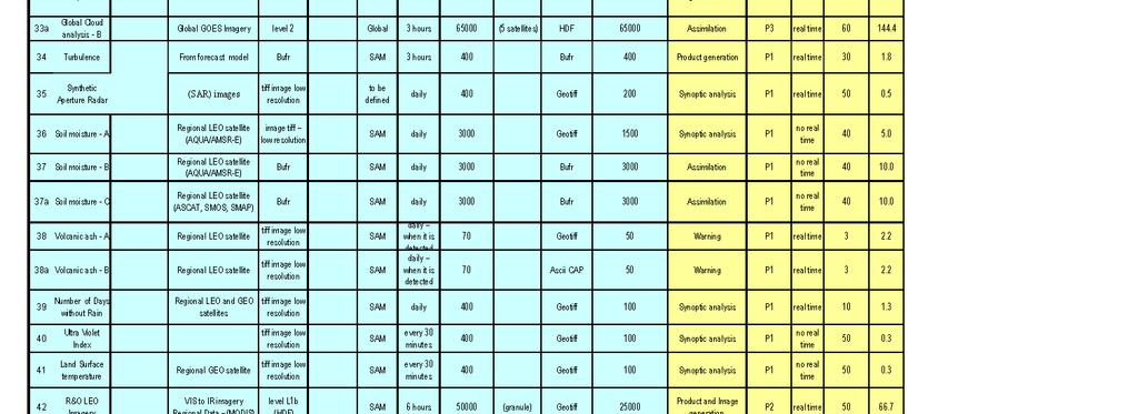
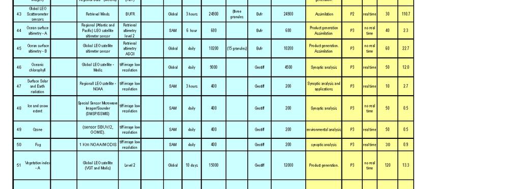
6 ANNEX II Regional Requirements Table This draft table is based on the latest 2011 version 3, with columns added: Data Provider (column C), Data Distribution (column F). product types identified by users are in light blue, and need to complemented by information from the data providers (in white); user requirements related to these product types are given in yellow. The table is available in Excel format for download at


7 7
8 ANNEX III Questionnaire for survey within RA III and RA IV (proposed version, 8 Nov 2013): 1) Country and name of your organization: 2) Type of your organization [ ] National meteorological/hydrological service [ ] Other operational governmental agency [ ] Regional/international organization [ ] Research/academic institution [ ] Other 1) What are your satellite data requirements? [Comment: this seems too general a question; it is suggested to split it into three questions: on satellite systems (Q3), on application areas (Q4), and on requirements for datasets (Q6)] 3) A) You are currently using data from which satellites: [ ] GOES-E [ ] GOES-W [ ] Meteosat-10 [ ] METOP [ ] CBERS [ ] POES [ ] Aqua/Terra [ ] DMSP [ ] Cloudsat/Calipso [ ] FY-3 [ ] METEOR-M [ ] NPP [ ] SPOT [ ] Oceansat [ ] GOSAT [ ] Landsat [ ] Aquarius/SAC-D [ ] SMOS [ ] SAR missions (Radarsat-2, TerraSAR-X, Cosmo-Skymed, TanDEM-X) [ ] Jason [ ] TRMM [ ] Megha-Tropiques [ ] HY [ ] COSMIC [ ] Other B) You are planning to use data from which satellites: [ ] GOES-R [ ] JPSS [ ] METOP [ ] Sentinel-3 [ ] Sentinel-1 [ ] Sentinel-2 [ ] FY-3 [ ] Landsat [ ] GCOM-W [ ] SMAP [ ] ADM-Aeolus [ ] GPM [ ] Jason-CS [ ] Other 4) What is your main use of satellite data? Weather forecasts and warnings [ ] Climate predictions and assessments [ ] Hydrological forecasts, warnings and assessments [ ] Oceanography and marine meteorology [ ] Space weather applications [ ] Disaster mitigation and preparedness [ ] Land monitoring (e.g., for agriculture) [ ] Environmental assessments [ ] Socio-economic mapping [ ] Research and development [ ] Education and training [ ] Other (please specify) [ ] 8
9 4) Data timeliness: are you mostly using Near-real time data (timeliness 0-48 hours) [ ] Historical data [ ] Both are equally important to me [ ] 5) A) How do you currently receive and access satellite data? Give details on the reception system (e.g., antenna) as appropriate. System Direct readout (e.g., HRPT) [ ] GTS point-to-point [ ] Internet (ftp, http) [ ] DVB-S/S2: GEONETCast-Americas [ ] DVB-S/S2: EUMETCast-Americas [ ] Other [ ] Details B) How would you like to receive satellite data in the future? System Direct readout (e.g., HRPT) [ ] GTS point-to-point [ ] Internet (ftp, http) [ ] DVB-S/S2: GEONETCast-Americas [ ] DVB-S/S2: EUMETCast-Americas [ ] Other [ ] Details 6) Do you intend to buy direct readout stations for the next satellite generation? Yes [ ] No [ ] Comments 7) Are you aware about of GEONETCast/EUMETCast? Yes [ ] No [ ] Comments 8) An initial set of satellite data requirements for RA III and RA IV has been developed; please comment, and add your requirements as necessary: Are you are aware of the RAIII and RAIV data requirements; if yes, do you agree with these satellite data requirements? If not please access the data requirement in the following address and comment. 7) What data reception system do you use? [Comment: covered by Q5] 9) Is this information useful for your service/institution? [Comment: not clear and perhaps redundant with Q4; if this question refers to the value of satellite data for the institution, suggest the following: ] In what context is satellite data being used for in your service/institution? Operations [ ] Research and Development [ ] Education [ ] Value-added services [ ] Other (pls specify) 9
10 9) Would you like to distribute data and products to other users in Region III and Region IV (e.g., by upload on the GEONETCast-Americas system)? Would you like to upload data and products to the Geonetcast system? [Comment: more general formulation of the question] No [ ] Yes [ ] Give details 10) Would your institution be ready/considering to contribute to a Region III/IV-wide data distribution system by allocating financial and technical resources? Is your institution ready/considering to contribute to the budget of the Geonetcast dissemination system? [Comment: again, more general formulation, not Geonetcast-centric] No [ ] Yes [ ] Give details 10
11 ANNEX IV Institutions responding to the 2012 WMO Survey on the Use of Satellite Data 4 in Region III and IV Region III (South America): 14 responses The 10 responses from NMHSs and other operational governmental agencies came from the following institutions (multiple responses possible): Centro Meteorológico Nacional, Argentina Servicio Meteorológico Nacional, Argentina INPE/CPTEC, Brazil Dirección Meteorológica de Chile INAMHI, Ecuador Servicio Nacional de Meteorologia e Hidrología del Peru Comisión Nacional de Investigación y Desarrollo Aeroespacial (CONIDA), Peru INGEMMET, Peru The 4 responses from Research & Academia came from the following institutions (multiple responses possible): CONICET, Argentina Universidade Federal do Rio de Janeiro, Brazil University of Sao Paulo, Brazil Federal University of Itajuba, Brazil Region IV (North/Central America and the Caribbean): 44 responses The 21 responses from NMHSs and other operational governmental agencies came from the following institutions (multiple responses possible): National Meteorological Service Belize Caribbean Meteorological Organization Meteorological Service of Canada Canadian Space Agency Environment Canada Instituto Costarricense de Electricidad Instituto Meteorologico Nacional Costa Rica Saint Lucia Meteorological Services NOAA National Environmental Satellite, Data, and Information Service NOAA National Weather Service NOAA National Climatic Data Center The 23 responses from Research & Academia came from the following institutions (multiple responses possible): Caribbean Institute for Meteorology and Hydrology University of Saskatchewan University of Toronto McGill University University of Waterloo
12 York University University of Alberta University of Calgary Université de Montréal Water Center for the Humid Tropics of Latin America and The Caribbean (CATHALAC) Center for Ocean-Atmosphere Prediction Studies, Florida State University Brigham Young University University of Texas Center for Space Research National Ecological Observatory Network National Snow and Ice Data Center, University of Colorado City College of New York NOAA NESDIS (at Cooperative Institute for Meteorological Satellite Studies, University of Wisconsin-Madison) 12
13 ANNEX V: NOAA GOES-13 Rapid Scanning Scenarios 13
Regional mechanisms for satellite data access and exchange: RA III/IV
 WORLD METEOROLOGICAL ORGANIZATION COMMISSION FOR BASIC SYSTEMS OPEN PROGRAMME AREA GROUP ON INTEGRATED OBSERVING SYSTEMS EXPERT TEAM ON SATELLITE UTILIZATION AND PRODUCTS ET-SUP-8/Doc. 5.1.3 (25.III.2014)
SATELLITE DATA REQUIREMENTS FOR RA III AND RA IV SURVEY REPORT. WMO Space Programme WMO
 WMO Space Programme SATELLITE DATA REQUIREMENTS FOR RA III AND RA IV SURVEY REPORT WMO 2014 Submitted by Diego Souza, Luiz A. T. Machado and Estela Collini World Meteorological Organization, 2014 The right
USER REQUIREMENTS FOR SATELLITE DATA: STATUS AND EVOLUTION
 USER REQUIREMENTS FOR SATELLITE DATA: STATUS AND EVOLUTION COORDINATION GROUP ON SATELLITE DATA REQUIREMENTS FOR REGION III AND IV FIRST SESSION GREENBELT, MD, USA, 27-28 APRIL 2015 Luiz A. T. Machado
Terms of Reference and Review of Activities
 Terms of Reference and Review of Activities COORDINATION GROUP ON SATELLITE DATA REQUIREMENTS FOR REGION III AND IV FIRST SESSION GREENBELT, MD, USA, 27-28 APRIL 2015 Stephan Bojinski, WMO WMO / OBS /
GOES-16 & GOES-S: Natalia Donoho. Preparing Users for New Generation Satellites. WMO IPET-SUP-4 Geneva, Switzerland 26 February, 2018
 GOES-16 & GOES-S: Preparing Users for New Generation Satellites Natalia Donoho Satellite Products and Services Division (NOAA/NESDIS) WMO IPET-SUP-4 Geneva, Switzerland 26 February, 2018 GOES-R series
RESULTS OF REGIONAL SATELLITE USER SURVEY IN RA III/IV. (Submitted by Diego Souza and Luiz A.T. Machado, INPE) Summary and Purpose of Document
 Summary and Purpose of Document") WORLD METEOROLOGICAL ORGANIZATION COMMISSION FOR BASIC SYSTEMS OPEN PROGRAMME AREA GROUP ON INTEGRATED OBSERVING SYSTEMS INTER-PROGRAMME EXPERT TEAM ON SATELLITE UTILIZATION AND PRODUCTS SECOND SESSION
WORLD METEOROLOGICAL ORGANIZATION COMMISSION FOR BASIC SYSTEMS OPEN PROGRAMME AREA GROUP ON INTEGRATED OBSERVING SYSTEMS INTER-PROGRAMME EXPERT TEAM ON SATELLITE UTILIZATION AND PRODUCTS SECOND SESSION
Recommendations from RA III/RA IV SDR -2 Training Task Team (SDR-TTT)
") WORLD METEOROLOGICAL ORGANIZATION COORDINATION GROUP ON SATELLITE DATA REQUIREMENTS FOR REGION III AND IV Recommendations from RA III/RA IV SDR -2 Training Task Team (SDR-TTT) KATHY-ANN CAESAR CARIBBEAN
WORLD METEOROLOGICAL ORGANIZATION COORDINATION GROUP ON SATELLITE DATA REQUIREMENTS FOR REGION III AND IV Recommendations from RA III/RA IV SDR -2 Training Task Team (SDR-TTT) KATHY-ANN CAESAR CARIBBEAN
REPORT ON 2015 SURVEY
 WMO Space Programme SP-11 SATELLITE DATA REQUIREMENTS FOR RA III AND RA IV REPORT ON 2015 SURVEY WMO 2016 Compiled by Diego Souza and Luiz A. T. Machado (INPE, Brazil) on behalf of the WMO Coordination
WMO 2016 Survey on the Use of Satellite Data
 WMO 2016 Survey on the Use of Satellite Data World Meteorological Organization (WMO) Space Programme 5 th Meeting of the Coordinating Group for the RA II WIGOS Project to Develop Support for NMHSs in Satellite
WMO Space Programme SP-9. WMO 2012 Survey on the Use of Satellite Data
 WMO Space Programme SP-9 WMO 2012 Survey on the Use of Satellite Data WMO Space Programme SP-9 WMO 2012 Survey on the Use of Satellite Data WMO 2013 World Meteorological Organization, 2013 The right of
WMO Coordination Group on Satellite Data Requirements for Region III and IV Sept 5-8, 2016 Willemstad, Curaçao
 WMO Coordination Group on Satellite Data Requirements for Region III and IV Sept 5-8, 2016 Willemstad, Curaçao 1. Current Satellite Reception 2. Preparation for Next-Gen GOES-R JPSS 3. Satellite Data Applications
Main Achievements. New Centre of Excellence in Morocco. Since ET-SUP
 Status and Plans New Centre of Excellence in Morocco Located in the WMO Regional Association I (RAI), the CoE Morocco is hosted by the National Directorate of Meteorology of Morocco and supported by EUMETSAT.
REPORT ON EUMETCAST INCLUDING GEONETCAST
 Prepared by EUMETSAT Agenda Item: F.2 Discussed in Plenary REPORT ON EUMETCAST INCLUDING GEONETCAST This paper presents the actual status of the system architecture, data services supported, and registration
WMO Space Programme SP-8. Status of the availability and use of satellite data and products by WMO Members For the period WMO-TD No.
 WMO Space Programme SP-8 Status of the availability and use of satellite data and products by WMO Members For the period 2008 2009 WMO-TD No. 1567 WMO Space Programme SP 8 Status of the availability and
Does the ATOVS RARS Network Matter for Global NWP? Brett Candy, Nigel Atkinson & Stephen English
 Does the ATOVS RARS Network Matter for Global NWP? Brett Candy, Nigel Atkinson & Stephen English Met Office, Exeter, United Kingdom 1. Introduction Along with other global numerical weather prediction
Status of EUMETSAT Operational Services & EUMETCast Africa Dissemination Baseline Updates
 Status of EUMETSAT Operational Services & EUMETCast Africa Dissemination Baseline Updates Sally Wannop User Relations Manager 1 8th WMO RAIDEG meeting 1-2 November 2017 # 951881 Overview EUMETCast Overview
Meteorological Service of Canada Perspectives. WMO Coordination Group on Satellite Data Requirements for RAIII/IV
 Meteorological Service of Canada Perspectives presented to the WMO Coordination Group on Satellite Data Requirements for RAIII/IV David Bradley Meteorological Service of Canada Environment Canada April
BMKG UPDATES ON SATELLITE-RELATED ACTIVITIES IN RA V
 UPDATES ON SATELLITE-RELATED ACTIVITIES IN RA V Riris Adriyanto (BMKG Indonesia / Member RA V TT-SU) With inputs from : Agnes Lane (Australian BoM / Leader RA V TT-SU) 1 Introduction Throughout these years,
Direct Readout at the Meteorological Service of Canada
 Direct Readout at the Meteorological Service of Canada CSPP Users Meeting 2015 Darmstadt, Germany April 14-16, 2015 David Bradley Manager, Earth Observation and Geomatics Meteorological Service of Canada
EARS-ATMS, EARS-CrIS and EARS-VIIRS: Three New Regional Services
 EARS-, EARS- and EARS-VIIRS: Three New Regional Services Anders Meier Soerensen, Ester Rojo, Thomas Heinemann, Michele Burla, Susanne Dieterle EUMETSAT Monitoring weather and climate from space Meteosat-7
GEONETCast Future Plans at CIMH
 GEONETCast Future Plans at CIMH Operations, Training, Climate Monitoring and Disaster Preparedness WORLD METEOROLOGICAL ORGANIZATION COORDINATION GROUP ON SATELLITE DATA REQUIREMENTS FOR REGION III AND
WGCapD Support to AmeriGEOSS Week Disaster Training Report
 WGCapD Support to AmeriGEOSS Week Disaster Training Report 1 6-9 June 2016 CEOS WGCapD Support to AmeriGEOSS Week Disaster training DRAFT REPORT Hosted by: The government's Institute of Hydrology, Meteorology,
LEVERAGING DWFI RESOURCES TO ADDRESS WATER FOR AGRICULTURE IN LATIN AMERICA UNDER A CHANGING CLIMATE
 LEVERAGING DWFI RESOURCES TO ADDRESS WATER FOR AGRICULTURE IN LATIN AMERICA UNDER A CHANGING CLIMATE Rachindra Mawalagedara Robert J. Oglesby Presented at the DWFI Student Support Research Forum, May 12,
Preparing for NOAA s Next Generation GOES-R & JPSS
 Preparing for NOAA s Next Generation GOES-R & JPSS Mark Paese Deputy Assistant Administrator NOAA Environmental Satellite & Information Service (NESDIS) WMO Cg-17: Ensuring User Readiness for New Generation
WMO Priorities and Perspectives on IPWG
 WMO Priorities and Perspectives on IPWG Stephan Bojinski WMO Space Programme IPWG-6, São José dos Campos, Brazil, 15-19 October 2012 1. Introduction to WMO Extended Abstract The World Meteorological Organization
Status report on current and future satellite systems by EUMETSAT Presented to CGMS-44, Plenary session, agenda item D.1
 Status report on current and future satellite systems by EUMETSAT Presented to CGMS-44, Plenary session, agenda item D.1 CGMS-44-EUMETSAT-WP-19.ppt, version 1 (# 859110), 8 June 2016 MISSION PLANNING YEAR...
DRR-related mandates and relevant activities and projects of RA III
 DRR-related mandates and relevant activities and projects of RA III 2015 Meeting of the Disaster Risk Reduction Focal Points of WMO Regional Associations, Technical Commissions and Programmes (DRR FP RA-TC-TP)
The Future of the USAP Antarctic Internet Data Distribution System
 The Future of the USAP Antarctic Internet Data Distribution System A discussion on LDM Efforts at ASC with Satellite Ground Stations update Andrew B. Archer Antarctic Support Contract Matthew A. Lazzara
Ocean Vector Wind Constellation:
 The CEOS Ocean Vector Wind Constellation: Current Status and Challenges Stan Wilson, NOAA; Hans Bonekamp, EUMETSAT; and B.S. Gohil, ISRO Co Chairs International OVW Science Team Meeting Barcelona 18 20
SECOND MEETING OF THE WORLD METEOROLOGICAL ORGANIZATION COORDINATION GROUP ON SATELLITE DATA REQUIREMENTS FOR RA III AND RA IV
 WORLD METEOROLOGICAL ORGANIZATION ============================================================== SECOND MEETING OF THE WORLD METEOROLOGICAL ORGANIZATION COORDINATION GROUP ON SATELLITE DATA REQUIREMENTS
EL NIÑO/LA NIÑA UPDATE
 World Meteorological Organization Monday 16 November 2015 EL NIÑO/LA NIÑA UPDATE Current Situation and Outlook A strong and mature El Niño continues in the tropical Pacific Ocean. The majority of international
An Eye in the Sky EUMETSAT. Monitoring Weather, Climate and the Environment
 An Eye in the Sky EUMETSAT Monitoring Weather, Climate and the Environment Slide: 1 Hazardous Weather Slide: 2 Hazardous Weather Slide: 3 Natural Disasters set off by severe weather Slide: 4 EUMETSAT Objectives...
Proper Data Management Responsibilities to Meet the Global Ocean Observing System (GOOS) Requirements
 Requirements") Data Buoy Cooperation Panel XXVI Oban, Scotland, UK 27 September 2010 Proper Data Management Responsibilities to Meet the Global Ocean Observing System (GOOS) Requirements William Burnett Data Management
Data Buoy Cooperation Panel XXVI Oban, Scotland, UK 27 September 2010 Proper Data Management Responsibilities to Meet the Global Ocean Observing System (GOOS) Requirements William Burnett Data Management
REPORT ON GEONETCAST In response to CGMS action/recommendation
 Prepared by EUMETSAT Agenda Item: G.2 Discussed in Plenary, WGI, WGII, WGIII, WGIV REPORT ON GEONETCAST In response to CGMS action/recommendation GEONETCast, which consists of a network of three dissemination
The use of Direct Broadcast Processing System in Poland
 The use of Direct Broadcast Processing System in Poland B.Łapeta, P.Struzik Satellite Remote Sensing Department, Institute of Meteortology and Water Management National Reasearch Institute About IMWM-NRI
EUMETSAT SAF NETWORK. Lothar Schüller, EUMETSAT SAF Network Manager
 1 EUMETSAT SAF NETWORK Lothar Schüller, EUMETSAT SAF Network Manager EUMETSAT ground segment overview METEOSAT JASON-2 INITIAL JOINT POLAR SYSTEM METOP NOAA SATELLITES CONTROL AND DATA ACQUISITION FLIGHT
EL NIÑO/LA NIÑA UPDATE
 July 2016 World Meteorological Organization EL NIÑO/LA NIÑA UPDATE Current Situation and Outlook The strong 2015-16 El Niño ended in May 2016. Since then, the El Niño/Southern Oscillation (ENSO) indicators
International Cooperation in Operational Environmental Satellites: The U.S. Experience
 Committee on the Peaceful Uses of Outer Space Science and Technology Sub committee Forty seventh session February 17, 2010 Vienna, Austria International Cooperation in Operational Environmental Satellites:
Follow-up to WMO 2012 Survey on the Use of Satellite Data: Feedback by RA I Members
 WMO Follow-up to WMO 2012 Survey on the Use of Satellite Data: Feedback by RA I Members Gillie Cheelo-Intern WMO Space Programme World Meteorological Organization (WMO) WMO; Observation and Information
JMA Contribution to SWFDDP in RAV. (Submitted by Yuki Honda and Masayuki Kyouda, Japan Meteorological Agency) Summary and purpose of document
 Summary and purpose of document") WORLD METEOROLOGICAL ORGANIZATION COMMISSION FOR BASIC SYSTEMS OPAG on DPFS DPFS/RAV-SWFDDP-RSMT Doc. 7.1(1) (28.X.2010) SEVERE WEATHER FORECASTING AND DISASTER RISK REDUCTION DEMONSTRATION PROJECT (SWFDDP)
WORLD METEOROLOGICAL ORGANIZATION COMMISSION FOR BASIC SYSTEMS OPAG on DPFS DPFS/RAV-SWFDDP-RSMT Doc. 7.1(1) (28.X.2010) SEVERE WEATHER FORECASTING AND DISASTER RISK REDUCTION DEMONSTRATION PROJECT (SWFDDP)
Copernicus Today and Tomorrow GEO Week Group on Earth Observation Geneva, 16 January 2014 The Copernicus Space Infrastructure
 Copernicus Today and Tomorrow GEO Week Group on Earth Observation Geneva, 16 January 2014 The Copernicus Space Infrastructure Thomas Beer, Policy Coordinator, Copernicus Space Office, ESA-ESRIN, Frascati
EUMETSAT EXPERIENCES IN RESPONDING TO THE REQUIREMENTS OF OPERATIONAL USERS
 EUMETSAT EXPERIENCES IN RESPONDING TO THE REQUIREMENTS OF OPERATIONAL USERS Outlook What is EUMETSAT How does EUMETSAT work Building capacity for a better utilisation of satellite data Example working
South Asian Climate Outlook Forum (SASCOF-6)
") Sixth Session of South Asian Climate Outlook Forum (SASCOF-6) Dhaka, Bangladesh, 19-22 April 2015 Consensus Statement Summary Below normal rainfall is most likely during the 2015 southwest monsoon season
Sixth Session of South Asian Climate Outlook Forum (SASCOF-6) Dhaka, Bangladesh, 19-22 April 2015 Consensus Statement Summary Below normal rainfall is most likely during the 2015 southwest monsoon season
EUMETSAT. A global operational satellite agency at the heart of Europe. Presentation for the Spanish Industry Day Madrid, 15 March 2012
 EUMETSAT A global operational satellite agency at the heart of Europe Presentation for the Spanish Industry Day Madrid, Angiolo Rolli EUMETSAT Director of Administration EUMETSAT objectives The primary
NWC-SAF Satellite Application Facility in Support to Nowcasting and Very Short Range Forecasting
 NWC-SAF Satellite Application Facility in Support to Nowcasting and Very Short Range Forecasting Marianne König Slide 1 Satellite Application Facilities (SAFs) in Europe Member State Cooperating State
SMN Argentina satellite summary. by Estela A COLLINI SHN-SMN
 SMN Argentina satellite summary by Estela A COLLINI SHN-SMN Outline (i) Status of satellite data reception (ii) Status of planning to receive new data (from GOES-R and other) (iii) Applications with satellite
June Current Situation and Outlook
 June 2018 Current Situation and Outlook Sea surface temperatures in the east-central tropical Pacific as well as most of the overlying atmospheric indicators suggest that ENSO-neutral conditions are prevailing;
FINDINGS OF THE ARCTIC METEOROLOGY SUMMIT
 FINDINGS OF THE ARCTIC METEOROLOGY SUMMIT 2018 WWW.FMI.FI CHAIR S SUMMARY: 1 2 3 We need to be curious to explore the known unknowns. Meteorology is an elemental part of international collaboration in
Current and Upcoming NASA Hurricane Measurement Missions National Hurricane Conference
 NASA Science Mission Directorate Earth Science Division Applied Sciences Program Current and Upcoming NASA Hurricane Measurement Missions National Hurricane Conference April 18, 2017 Formulation Implementation
7 th WMO RAI Dissemination Expert working Group RAIDEG report. Mariane Diop Kane, Chair
 7 th WMO RAI Dissemination Expert working Group RAIDEG report Mariane Diop Kane, Chair Overview Established in 2010 by WMO, in cooperation with EUMETSAT Endorsed by WMO RA-I at its 16 th session in 2015,
COUNTRY REPORT INDONESIA
 COUNTRY REPORT INDONESIA Badan Meteorologi Klimatologi dan Geofisika (BMKG) Agency For Meteorology, Climatology, and Geophysics Republic of Indonesia DKI Jakarta, Indonesia Tel. (021) 4246321 Email: pcs@bmkg.go.id
The International Charter Space and Major Disasters is further strengthening its contribution to disaster management worldwide.
 28 September 2012 Issue 3 The International Charter Space and Major Disasters is further strengthening its contribution to disaster management worldwide. Building on a decade of success in making satellite
EL NIÑO/LA NIÑA UPDATE
 5 OCTOBER 2017 World Meteorological Organization EL NIÑO/LA NIÑA UPDATE Current Situation and Outlook Sea surface temperatures in the eastern tropical Pacific Ocean have recently cooled to below normal
EUMETSAT REPORT ON GEONETCAST
 Prepared by EUMETSAT Agenda Item: WGIV/5 Discussed in WGIV EUMETSAT REPORT ON GEONETCAST GEONETCast, which consists of a network of three dissemination systems - GEONETCast Americas operated by NOAA, FENGYUNCast
EL NIÑO/LA NIÑA UPDATE
 World Meteorological Organization EL NIÑO/LA NIÑA UPDATE Current Situation and Outlook A mature and strong El Niño is now present in the tropical Pacific Ocean. The majority of international climate outlook
Weather Satellite Data Applications for Monitoring and Warning Hazard at BMKG
 The 5th Meeting of the Coordinating Group of the RA II WIGOS Satellite Project 21 October 2017, Vladivostok city, Russky Island, Russia Far Eastern Federal University Weather Satellite Data Applications
Regional Hazardous Weather Advisory Centres (RHWACs)
") Regional Hazardous Weather Advisory Centres (RHWACs) The following outlines the criteria for the selection of RHWACs based on operational and functional requirements 1. Basic Principles The RHWAC must:
Regional Hazardous Weather Advisory Centres (RHWACs) The following outlines the criteria for the selection of RHWACs based on operational and functional requirements 1. Basic Principles The RHWAC must:
WMO Space Programme SP-4. Status of the availability and use of satellite data and products by WMO Members For the period WMO-TD No.
 WMO Space Programme SP-4 Status of the availability and use of satellite data and products by WMO Members For the period 2004 2005 WMO-TD No. 1423 STATUS OF THE AVAILABILITY AND USE OF SATELLITE DATA AND
Satellite User Readiness through Training: VISIT, SHyMet, WMO VLab, and Liaisons
 Satellite User Readiness through Training: VISIT, SHyMet, WMO VLab, and Liaisons Bernadette Connell 1 D. Bikos 1, S. Lindstrom 2, J. Torres 1, E. J. Szoke 1, E. L. Dagg 1, A. B. Schumacher 1, A. S. Bachmeier
EL NIÑO/LA NIÑA UPDATE
 28 April 2017 World Meteorological Organization EL NIÑO/LA NIÑA UPDATE Current Situation and Outlook Neutral El Niño/Southern Oscillation (ENSO) conditions currently exist in the tropical Pacific Ocean.
EUMETSAT SAF NETWORK. Lothar Schüller, EUMETSAT SAF Network Manager
 1 EUMETSAT SAF NETWORK Lothar Schüller, EUMETSAT SAF Network Manager EUMETSAT ground segment overview METEOSAT JASON-2 INITIAL JOINT POLAR SYSTEM METOP NOAA SATELLITES CONTROL AND DATA ACQUISITION FLIGHT
Maryland Space. Business Roundtable. Satellite and Information Service. Stephen Volz, Ph.D., Assistant Administrator. January 2018
 Maryland Space Satellite and Information Service Business Roundtable Stephen Volz, Ph.D., Assistant Administrator January 2018 Delivering on the Commitment JPSS-1 Launch Nov 18, 2017 GOES-R Launch Nov
NOAA Direct Broadcast Data Initiative to Meet NWP Latency Requirements
 Prepared by M. Goldberg Agenda Item: II/2 Discussed in WG-II NOAA Direct Broadcast Data Initiative to Meet NWP Latency Requirements Summary of the Working Paper Action 40.18: CGMS Agencies to support fast
COORDINATION WITH OTHER ACTIVITIES OF THE WMO TROPICAL CYCLONE PROGRAMME. (Submitted by the WMO Secretariat) Summary and Purpose of Document
 Summary and Purpose of Document") ESCAP/WMO TYPHOON COMMITTEE FORTY-NINTH SESSION 21-24 FEBRUARY 2017 YOKOHAMA, JAPAN FOR PARTICIPANTS ONLY WRD/TC.49/16 13 February 2017 ENGLISH ONLY COORDINATION WITH OTHER ACTIVITIES OF THE WMO TROPICAL
ESCAP/WMO TYPHOON COMMITTEE FORTY-NINTH SESSION 21-24 FEBRUARY 2017 YOKOHAMA, JAPAN FOR PARTICIPANTS ONLY WRD/TC.49/16 13 February 2017 ENGLISH ONLY COORDINATION WITH OTHER ACTIVITIES OF THE WMO TROPICAL
A Questionnaire on the Utilization of Satellite Data from the New Generation of Geostationary Meteorological Satellites
 3.1 User requirements for satellite data utilization, especially for new-generation satellites A Questionnaire on the Utilization of Satellite Data from the New Generation of Geostationary Meteorological
EL NIÑO/LA NIÑA UPDATE
 13 May 2016 World Meteorological Organization EL NIÑO/LA NIÑA UPDATE Current Situation and Outlook The previously strong 2015-16 El Niño is now weakening rapidly. However it is still likely to influence
GSCB Workshop 2009: EUMETSAT Missions
 GSCB Workshop 2009: EUMETSAT Missions Dr. Harald Rothfuss, EUMETSAT. GSCB Workshop 2007, ESRIN, Frascati, 18-19 June 2009. Slide: 1 Introduction To EUMETSAT The European Organisation for the Exploitation
RA III Radiosonde Training Workshop, Buenos Aires, May 2006
 RA III Radiosonde Training Workshop, Buenos Aires, May 2006 J. Nash, R. Smout, M. Smees Met Office, Exeter, UK and M.J. Garcia Servicio Meteorologico Nacional, Argentina 1. Introduction Regional radiosonde
World Meteorological Organization Working together in weather, climate and water
 WMO World Meteorological Organization Working together in weather, climate and water Strengthening Regional Cooperation to Support Forecasting with Multi-Hazard Approach in RA IV SWFDP concepts and lessons
Introduction of JMA VLab Support Site on RGB Composite Imagery and tentative RGBs
 The Sixth Asia/Oceania Meteorological Satellite Users' Conference 9 13 November 2015, Tokyo/Japan J M A Introduction of JMA VLab Support Site on RGB Composite Imagery and tentative RGBs Akihiro SHIMIZU
Casablanca s Centre of Excellency,
 Centre d Excellence s Centre of Excellency, 2013-2015 action plan report, 2016-2018 action plan Noureddine Filali B. ( CoE s Focal point) Agenda: Introduction Main achievement 2013-2015 report: 2016 survey
NOAA Direct Broadcast Real-Time Network Status
 NOAA Direct Broadcast Real-Time Network Status Liam Gumley (CIMSS/SSEC/UW-Madison) Mitch Goldberg (JPSS/NOAA) WMO DBNET Operators Meeting Sept 2016 Overview NOAA antennas for Honolulu, Madison, Miami,
ASSOCIATION OF CARIBBEAN STATES (ACS / AEC)
") ASSOCIATION OF CARIBBEAN STATES (ACS / AEC) 1 SHOCS (Strengthening Hydrometorological Operations and Services in Caribbean SIDS) The ACS/Finnish Government response to Hydrometorological risk in Caribbean
ASSOCIATION OF CARIBBEAN STATES (ACS / AEC) 1 SHOCS (Strengthening Hydrometorological Operations and Services in Caribbean SIDS) The ACS/Finnish Government response to Hydrometorological risk in Caribbean
South Asian Climate Outlook Forum (SASCOF-12)
") Twelfth Session of South Asian Climate Outlook Forum (SASCOF-12) Pune, India, 19-20 April 2018 Consensus Statement Summary Normal rainfall is most likely during the 2018 southwest monsoon season (June
Twelfth Session of South Asian Climate Outlook Forum (SASCOF-12) Pune, India, 19-20 April 2018 Consensus Statement Summary Normal rainfall is most likely during the 2018 southwest monsoon season (June
Weather Observing and Forecasting and the Hurricane Warning System in the Caribbean
 T.W. Sutherland: Weather Observing and Forecasting and the Hurricane Warning System in the Caribbean 6 ISSN 1000 7924 The Journal of the Association of Professional Engineers of Trinidad and Tobago Vol.42,
Add NOAA nowcoast Layers to Maps
 WebEOC Maps Add-on Quick Reference Guide Add NOAA nowcoast Layers to Maps Overview With Maps Add-on, you can configure an unlimited number of map layers. These layers allow you to control the data you
REGIONAL SATELLITE DATA REQUIREMENTS AND DATA EXCHANGE UPDATES ON SATELLITE-RELATED ACTIVITIES IN RA V
 WORLD METEOROLOGICAL ORGANIZATION COMMISSION FOR BASIC SYSTEMS OPEN PROGRAMME AREA GROUP ON INTEGRATED OBSERVING SYSTEMS INTER-PROGRAMME EXPERT TEAM ON SATELLITE UTILIZATION AND PRODUCTS THIRD SESSION
STATUS OF JAPANESE METEOROLOGICAL SATELLITES AND RECENT ACTIVITIES OF MSC
 STATUS OF JAPANESE METEOROLOGICAL SATELLITES AND RECENT ACTIVITIES OF MSC Daisaku Uesawa Meteorological Satellite Center, Japan Meteorological Agency Abstract MTSAT-1R is the current operational Japanese
Executive Summary and Recommendations
 ANNEX I: EXECUTIVE SUMMARY AND RECOMMENDATIONS OF THE 12RMSD TWELFTH REGIONAL MEETING OF THE METEOROLOGICAL SERVICE DIRECTORS 30 -JUNE to 6 -JULY 2007 Rarotonga, Cook Islands Executive Summary and Recommendations
[NEACOF] Status Report (Survey)
![[NEACOF] Status Report (Survey)](/thumbs/96/126988285.jpg "[NEACOF] Status Report (Survey)") [NEACOF] Status Report (Survey) Annotated Outline Specific Climate features of concerned region In North Eurasian region, wintertime temperature is mainly a result from interplay of advection of the warm
[NEACOF] Status Report (Survey) Annotated Outline Specific Climate features of concerned region In North Eurasian region, wintertime temperature is mainly a result from interplay of advection of the warm
Himawari 8/9 data distribution/dissemination plan
 Himawari 8/9 data distribution/dissemination plan Japan Meteorological Agency (JMA) Hidehiko MURATA Himawari is the name of this flower in Japanese ET SUP 8, WMO HQ, Geneva, 14 17 April 2014 1 Outline
UPDATE ON RARS. Action/Recommendation proposed:
 Prepared by WMO Agenda Item: IV.4 Discussed in WG IV UPDATE ON RARS A brief report is provided on the global network of Regional ATOVS Retransmission Services (RARS). As of 1 October 2009, the global RARS
THE IMPACT OF EL NIÑO AND LA NIÑA ON SOUTHEAST ASIA
 THE IMPACT OF EL NIÑO AND LA NIÑA ON SOUTHEAST ASIA 21st-23rd February 2000 WORKSHOP SUMMARY Organized by the Indochina Global Change Network Funded by the Asia-Pacific Network for Global Change Research
Benefits of the new-generation Himawari-8 geostationary satellite for the Asia-Pacific region. Toshihiko HASHIDA Japan Meteorological Agency (JMA)
") Benefits of the new-generation Himawari-8 geostationary satellite for the Asia-Pacific region Toshihiko HASHIDA Japan Meteorological Agency (JMA) Side Event Ensuring User Readiness to New-Generation Meteorological
Benefits of the new-generation Himawari-8 geostationary satellite for the Asia-Pacific region Toshihiko HASHIDA Japan Meteorological Agency (JMA) Side Event Ensuring User Readiness to New-Generation Meteorological
Some NOAA Products that Address PSTG Satellite Observing Requirements. Jeff Key NOAA/NESDIS Madison, Wisconsin USA
 Some NOAA Products that Address PSTG Satellite Observing Requirements Jeff Key NOAA/NESDIS Madison, Wisconsin USA WMO Polar Space Task Group, 4 th meeting, Greenbelt, 30 September 2014 Relevant Missions
The North American Drought Monitor - The Canadian Perspective -
 The North American Drought Monitor - The Canadian Perspective - Trevor Hadwen National Agroclimate Information Service AAFC-PFRA, Regina Canmore, Alberta March 16-18, 2008 Background The NADM is a cooperative
OPAG on Integrated Observing Systems. Workshop to Improve the Usefulness of Operational Radiosonde Data. (Submitted by the Secretariat)
") WORLD METEOROLOGICAL ORGANIZATION COMMISSION FOR BASIC SYSTEMS CBS MANAGEMENT GROUP Fourth session Langen, Germany, 13-16 October 2003 Distr.: RESTRICTED CBS/MG-IV/Doc. 3.1(5) (24.IX.2003) ITEM: 3.1 ENGLISH
WORLD METEOROLOGICAL ORGANIZATION COMMISSION FOR BASIC SYSTEMS CBS MANAGEMENT GROUP Fourth session Langen, Germany, 13-16 October 2003 Distr.: RESTRICTED CBS/MG-IV/Doc. 3.1(5) (24.IX.2003) ITEM: 3.1 ENGLISH
DEBRIEFING REPORT. COTOPAXI VOLCANO EXERCISE 13 th NOVEMBER WP 9: Decision-making and unrest management
 COTOPAXI VOLCANO EXERCISE 13 th NOVEMBER 2014 WP 9: Decision-making and unrest management Task 9.6: Simulation of unrest and decision making DEBRIEFING REPORT INTRODUCTION The third VUELCO exercise took
CopernicusEU. the EU's Earth Observation Programme. Sara Zennaro Atre Delegation of the European Union to Japan
 Copernicus the EU's Earth Observation Programme Sara Zennaro Atre Delegation of the European Union to Japan Status Overview, Sept 2016 & Ocean Policies Seminar 4 October 2016 ollow us on: Copernicus EU
MADIS Airlines for America Briefing
 MADIS Airlines for America Briefing Meteorological Assimilated Data Ingest System (MADIS) FPAW Briefing Steve Pritchett NWS Aircraft Based Observations Program Manager MADIS Defined MADIS is a meteorological
INCA-CE achievements and status
 INCA-CE achievements and status Franziska Strauss Yong Wang Alexander Kann Benedikt Bica Ingo Meirold-Mautner INCA Central Europe Integrated nowcasting for the Central European area This project is implemented
National Public Weather and Warning Services in the Swaziland Meteorological Service Dennis S.Mkhonta /
 National Public Weather and Warning Services in the Swaziland Meteorological Service Dennis S.Mkhonta dennis.mkhonta@gmail.com / dennis@swazimet.gov.sz Introduction Swaziland s geographical position exposes
Climate Services in Seychelles
 Climate Services in Seychelles Vincent Amelie Seychelles Met. Services Email: v.amelie@meteo.gov.sc Regional Consultation on Climate Services in the Indian Ocean Islands, Ebène, Mauritius, 14-16 March
Dissemination of Global Products from EUMETSAT
 Dissemination of Global Products from EUMETSAT Simon Elliott EUMETSAT simon.elliott@eumetsat.int Beijing, 23 May - 1 June 2005 Slide 1 Overview NRT Replaced by EUMETCast What is EUMETCast? Which data sets
FOURTH INTERNATIONAL PORT METEOROLOGICAL OFFICERS WORKSHOP AND SUPPORT TO GLOBAL OCEAN OBSERVATIONS USING SHIP LOGISTICS
 FOURTH INTERNATIONAL PORT METEOROLOGICAL OFFICERS WORKSHOP AND SUPPORT TO GLOBAL OCEAN OBSERVATIONS USING SHIP LOGISTICS PMO-IV 8-10 DEC 2010, ORLANDO, FLORIDA, USA 1 This presentation is generally for
Space Based Global Observing System Requirements for Satellite Sounders. Dr. Jian Liu Space Programme World Meteorological Organization
 Space Based Global Observing System Requirements for Satellite Sounders Dr. Jian Liu Space Programme World Meteorological Organization Outline 1. satellite sounders capabilities 2. User requirements 3.
Monitoring Sand and Dust Storms from Space
 Monitoring Sand and Dust Storms from Space for Expert Consultation on Disaster Information and Knowledge, Session 2 ICC 21 for ESCAP s RESAP and CDRR 5 9 12 October, 2017 Toshiyuki KURINO WMO Space Programme
MONITORING WEATHER AND CLIMATE FROM SPACE
 1 EUM/TSS/VWG/15/801307, April 2015 MONITORING WEATHER AND CLIMATE FROM SPACE Evolution of the EUMETSAT Advanced Retransmission Service (EARS) Anders Soerensen EUMETSAT EUMETSAT Advanced Retransmission
An Update on EUMETSAT Programmes and Plans. Dieter Klaes on behalf of EUMETSAT teams
 An Update on EUMETSAT Programmes and Plans Dieter Klaes on behalf of EUMETSAT teams 1 21 st International TOVS Study Conference (ITSC), Darmstadt, Germany, 29 November 2017 5 December 2017 Current EUMETSAT
P3.13 GLOBAL COMPOSITE OF VOLCANIC ASH SPLIT ` WINDOW GEOSTATIONARY SATELLITE IMAGES
 P3.13 GLOBAL COMPOSITE OF VOLCANIC ASH SPLIT ` WINDOW GEOSTATIONARY SATELLITE IMAGES Frederick R. Mosher * Embry-Riddle Aeronautical University Daytona Beach, FL 1.0 Introduction Volcanic ash is exceptionally