Modeling and Observation of Loading Contribution to Time-Variable GPS Site Positions
|
|
|
- Alexina Fleming
- 5 years ago
- Views:
Transcription


1 EGU Session G4 EGU General Assembly 2009 Vienna, Austria, April 2009 Modeling and Observation of Loading Contribution to Time-Variable GPS Site Positions Are we able to Detect and Identify Loading Contribution inside GPS Position? Does the Integration of Loading in GPS Processing improve Vertical Positioning? P. Gegout, F. Perosanz DTP/CNES/GRGS, 14 avenue Édouard Belin, Toulouse, France J.-P. Boy, J. Hinderer IPGS UMR 7516, 5 rue Descartes, Strasbourg, France G. Ferhat INSA de Strasbourg, 24 blvd de la Victoire, Strasbourg, France


![, 2002] - Spherical Harmonics for Global Maps](/docs-images/94/120863306/images/2-7.jpg "Atmospheric Loading (6-hourly) - ECMWF")
 - Static response: IB")
")
![- GLDAS [M. Rodell, 2004] - ECMWF [P.](/docs-images/94/120863306/images/2-10.jpg "Viterbo, 1995] Variability of the vertical")
2 Modeling the Loading Contribution to Time-Variable GPS Sites Positions Period, 6-hourly, 3D site displacements: - Refined Green s functions [J.-P. Boy et al., 2002] - Spherical Harmonics for Global Maps Atmospheric Loading (6-hourly) - ECMWF Operational Analysis - NCEP Reanalysis Oceanic Loading (6-hourly) - Static response: IB (Inverted Barometer) - Dynamic response: MOG2D [F. Lyard,2003] Hydrological Loading (6-hourly) - GLDAS [M. Rodell, 2004] - ECMWF [P. Viterbo, 1995] Variability of the vertical displacement: Root Mean Squares estimated in 2002.


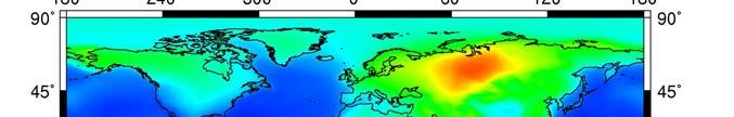


3 Atmosphere + Ocean Loadings (ECMWF-MOG2D, 6-hourly) Hydrological Loading (GLDAS/NOAH, 3 hourly) RMS Land = 1.7 mm RMS Land = 5.31 mm RMS Land = 0.9 mm

4 Atmosphere: ECMWF vs. NCEP Ocean: IB vs. Dynamic MOG2D RMSLand = 0.70 mm RMSLand = 1.44 mm GLDAS vs. ECMWF Hydrology Soil Moisture & Snow RMSLand = 1.2 mm RMSLand = 0.9 mm


 using the Apply ATM load GAMIT feature implemented by")
![[ Tregoning & van Dam, 2005 ]. GAMIT/GLOBK 10.](/docs-images/94/120863306/images/5-4.jpg "33: Enhanced Ambiguity Resolution Scheme Cutoff elevation = 10 ; Interval")
5 Observation of Time-Variable Site Positions Single GAMIT analysis of 100 sites among IGS best sites equally distributed around the world. Form as many as possible double differences to: Tighten the network Enhance ambiguity resolutions Enhance realization of the reference frame Process twice the 6-yr series: Once without the load (GPS NO LOAD) Integrating the AOH loading model (GPS&AOH) using the Apply ATM load GAMIT feature implemented by [ Tregoning & van Dam, 2005 ]. GAMIT/GLOBK 10.33: Enhanced Ambiguity Resolution Scheme Cutoff elevation = 10 ; Interval Zenith delay = 2 hours Use Tide model with degree 1 deformation
6 INV (ECMWF & IB)
7 MOG (ECMWF & MOG2D)

8 AOH (ECMWF & MOG2D & GLDAS)
9 AOH (ECMWF & MOG2D & GLDAS)
10 AOH (ECMWF & MOG2D & GLDAS) AOH (ECMWF & MOG2D & GLDAS)
11 GPS&AOH (A PRIORI: ECMWF & MOG2D & GLDAS) Red lower than Green shows a decrease of variability
 Red lower than Green shows a")

12 GPS&AOH (A PRIORI: ECMWF & MOG2D & GLDAS) Red lower than Green shows a decrease of variability Red lower than Green shows a decrease of variability
 Red lower than black is")
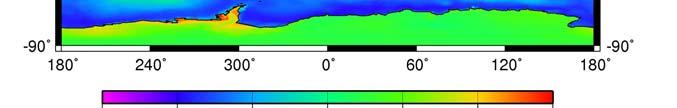
13 Annual Variability of the Vertical Displacement: Northern Hemisphere GPS&AOH (A PRIORI AOH) Red lower than black is better


14 Annual Variability of the Vertical Displacement: Conclusions for the Northern Hemisphere GPS&AOH (A PRIORI AOH) Red lower than black is better Improvements : Large continental areas: Eurasia, North America Why? Large Atmospheric and Hydrological Signals. Less Oceanic Influence. Well known high and mid-latitudes weather conditions GPS Tracking Network.

15 AOH (ECMWF & MOG2D & GLDAS)
16 GPS&AOH (A PRIORI: ECMWF & MOG2D & GLDAS)


 Elevation")
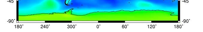
17 Annual Variability of the Vertical Displacement: Conclusions for the Southern Hemisphere GPS&AOH (A PRIORI AOH) Red greater than black is worse No improvements : Peninsulas, Islands, Coastal Sites Why? Tracking Network? Tiny loading signal? Tides? Unmodeled Oceanic Loading? Tropospheric delays (use of ZTD & VMF) Elevation weighting ( too much weight on low elevation )


 - Florent Lyard (MOG2D), Matthew Rodell (GLDAS) -")
18 EGU Session G4 EGU General Assembly 2009 Vienna, Austria, April 2009 Modeling and Observation of Loading Contribution to Time-Variable GPS Site Positions Are we able to Detect and Identify Loading Contribution inside GPS Position? YES! Does the Integration of Loading in GPS Processing improve Vertical Positioning at All Sites? Tropospheric effects are not accurately modeled in our current study and mask loading signal for sites near costal areas. Acknowledgements: - GAMITeers (P. Tregoning, T. Herring, R. King, ) - Florent Lyard (MOG2D), Matthew Rodell (GLDAS) - Meteorological Centers (ECMWF, NCEP) - GPS Rinex Archive Centers (IGS, SOPAC, UNAVCO) This work was supported by the Centre National d Etudes Spatiales (CNES).
Modeling and Observation of Loading Contribution to Time-Variable GPS Site Positions
 EGU2009-3768 Session G4 EGU General Assembly 2009 Vienna, Austria, 19 24 April 2009 Modeling and Observation of Loading Contribution to Time-Variable GPS Site Positions Are we able to Detect and Identify
Global Mapping Function (GMF): A new empirical mapping function based on numerical weather model data
: A new empirical mapping function based on numerical weather model data") Johannes Böhm, Arthur Niell, Paul Tregoning, and Harald Schuh Global Mapping Function (GMF): A new empirical mapping function based on numerical weather model data Geophysical Research Letters Vol. 33,
Johannes Böhm, Arthur Niell, Paul Tregoning, and Harald Schuh Global Mapping Function (GMF): A new empirical mapping function based on numerical weather model data Geophysical Research Letters Vol. 33,
The Global Mapping Function (GMF): A new empirical mapping function based on numerical weather model data
: A new empirical mapping function based on numerical weather model data") The Global Mapping Function (GMF): A new empirical mapping function based on numerical weather model data J. Boehm, A. Niell, P. Tregoning, H. Schuh Troposphere mapping functions are used in the analyses
The Global Mapping Function (GMF): A new empirical mapping function based on numerical weather model data J. Boehm, A. Niell, P. Tregoning, H. Schuh Troposphere mapping functions are used in the analyses
Summary of the 2012 Global Geophysical Fluid Center Workshop
 Summary of the 2012 Global Geophysical Fluid Center Workshop T. van Dam (Uni. Lux), J. Ray (NGS/NOAA), X. Collilieux (IGN) Introduction Review the history of the GGFC Discuss the 2012 Workshop Review recommendations
Call for space geodetic solutions corrected for non-tidal atmospheric loading (NT-ATML) at the observation level
 at the observation level") Call for space geodetic solutions corrected for non-tidal atmospheric loading (NT-ATML) at the observation level Xavier Collilieux, Tonie van Dam, Zuheir Altamimi Outline: Context Why correcting for non-tidal
Call for space geodetic solutions corrected for non-tidal atmospheric loading (NT-ATML) at the observation level Xavier Collilieux, Tonie van Dam, Zuheir Altamimi Outline: Context Why correcting for non-tidal
Impact of a priori zenith hydrostatic delay errors on GPS estimates of station heights and zenith total delays
 Click Here for Full Article GEOPHYSICAL RESEARCH LETTERS, VOL. 33, L23303, doi:10.1029/2006gl027706, 2006 Impact of a priori zenith hydrostatic delay errors on GPS estimates of station heights and zenith
Analysis of the Accuracy of GMF, NMF, and VMF1 Mapping Functions with GPT 50 a Priori Zenith Constraint in Tropospheric Delay Modelling
 Analysis of the Accuracy of GMF, NMF, and VMF1 Mapping Functions with GPT 50 a Priori Zenith Constraint in Tropospheric Delay Modelling Brian Makabayi 1 Addisu Hunegnaw 2 1 Assistant Lecturer, Department
Estimating Atmospheric Water Vapor with Groundbased. Lecture 12
 Estimating Atmospheric Water Vapor with Groundbased GPS Lecture 12 Overview This lecture covers metrological applica4ons of GPS Some of the material has already been presented and is shown here for completeness.
atmospheric and induced non-tidal oceanic loading contributions to surface gravity and tilt measurements.
 Modelling atmospheric and induced non-tidal oceanic loading contributions to surface gravity and tilt measurements Jean-Paul Boy, Laurent Longuevergne, Frédéric Boudin, Thomas Jacob, Florent Lyard, Muriel
State-of-the-art physical models for calculating atmospheric pressure loading effects
 State-of-the-art physical models for calculating atmospheric pressure loading effects Dudy D. Wijaya, Böhm J., Schindelegger M., Karbon M., Schuh H. Institute of Geodesy and Geophysics, TU Vienna Geodätische
The BIFROST Project: 21 years of search for the true crustal deformation in Fennoscandia
 The BIFROST Project: 21 years of search for the true crustal deformation in Fennoscandia Martin Lidberg and Holger Steffen Lantmäteriet, Sweden Jan Johansson Chalmers University of Technology Halfdan Kierulf
Accuracy of GPS Positioning in the Presence of Large Height Differences
 Accuracy of GPS Positioning in the Presence of Large Height Differences by D. Ugur Sanli & F. Kurumahmut Background Large height difference between baseline points First mentioned by Gurtner et al. 1989
Surface Mass Loads from GRACE, GPS, and Earth Rotation
 Surface Mass Loads from GRACE,, and Earth Rotation R. Gross *, G. Blewitt, H.-P. Plag, P. Clarke, D. Lavallée, T. van Dam *Jet Propulsion Laboratory, California Institute of Technology, Pasadena, USA Nevada
Copyright 2004 American Geophysical Union. Further reproduction or electronic distribution is not permitted.
 Copyright 2004 American Geophysical Union. Further reproduction or electronic distribution is not permitted. Citation: Thompson, P. F., S. V. Bettadpur, and B. D. Tapley (2004), Impact of short period,
Effects of Unresolved High-Frequency Signals in Altimeter Records Inferred from Tide Gauge Data
 534 JOURNAL OF ATMOSPHERIC AND OCEANIC TECHNOLOGY VOLUME 19 Effects of Unresolved High-Frequency Signals in Altimeter Records Inferred from Tide Gauge Data RUI M. PONTE Atmospheric and Environmental Research,
Towards a Consistent Conventional Treatment of Surface-Load Induced Deformations
 Towards a Consistent Conventional Treatment of Surface-Load Induced Deformations Hans-Peter Plag(1), Geoff Blewitt, Tom A. Herring (1) Nevada Bureau of Mines and Geology and Seismological Laboratory University
Atmospheric Effects in Space Geodesy
 Atmospheric Effects in Space Geodesy Johannes Böhm 18 November 2011 @ UNESP, Presidente Prudente, Brazil The atmosphere.. is not only causing troubles in space geodesy.. but it opens up a wide field of
Hydrological deformation induced by the West African Monsoon: Comparison of GPS, GRACE and loading models
 JOURNAL OF GEOPHYSICAL RESEARCH, VOL. 117,, doi:10.1029/2011jb009102, 2012 Hydrological deformation induced by the West African Monsoon: Comparison of GPS, GRACE and loading models Samuel Nahmani, 1 Olivier
Deriving groundwater estimates in Australia from GRACE observations
 Deriving groundwater estimates in Australia from GRACE observations P. Tregoning 1 and S.C. McClusky 1 1 Research School of Earth Sciences, The Australian National University, Canberra, ACT, 0200, Australia,
Geophysical Correction Application in Level 2 CryoSat Data Products
 ESRIN-EOP-GQ / IDEAS IDEAS-VEG-IPF-MEM-1288 Version 2.0 29 July 2014 Geophysical Correction Application in Level 2 CryoSat Data Products TABLE OF CONTENTS 1 INTRODUCTION... 3 1.1 Purpose and Scope... 3
Relationships between mass redistribution, station position, geocenter, and Earth rotation: Results from IGS GNAAC analysis
 Relationships between mass redistribution, station position, geocenter, and Earth rotation: Results from IGS GNAAC analysis Geoff Blewitt Mackay School of Earth Sciences and Engineering University of Nevada,
Correction to Atmospheric Effects and Spurious Signals in GPS Analyses
 JOURNAL OF GEOPHYSICAL RESEARCH, VOL.???, XXXX, DOI:10.1029/, 1 2 Correction to Atmospheric Effects and Spurious Signals in GPS Analyses P. Tregoning 3 4 Research School of Earth Sciences, The Australian
IMPACT OF GROUND-BASED GPS PRECIPITABLE WATER VAPOR AND COSMIC GPS REFRACTIVITY PROFILE ON HURRICANE DEAN FORECAST. (a) (b) (c)
 (b) (c)") 9B.3 IMPACT OF GROUND-BASED GPS PRECIPITABLE WATER VAPOR AND COSMIC GPS REFRACTIVITY PROFILE ON HURRICANE DEAN FORECAST Tetsuya Iwabuchi *, J. J. Braun, and T. Van Hove UCAR, Boulder, Colorado 1. INTRODUCTION
9B.3 IMPACT OF GROUND-BASED GPS PRECIPITABLE WATER VAPOR AND COSMIC GPS REFRACTIVITY PROFILE ON HURRICANE DEAN FORECAST Tetsuya Iwabuchi *, J. J. Braun, and T. Van Hove UCAR, Boulder, Colorado 1. INTRODUCTION
Impact of short period, non-tidal, temporal mass variability on GRACE gravity estimates
 GEOPHYSICAL RESEARCH LETTERS, VOL. 31, L06619, doi:10.1029/2003gl019285, 2004 Impact of short period, non-tidal, temporal mass variability on GRACE gravity estimates P. F. Thompson, S. V. Bettadpur, and
Christina Selle, Shailen Desai IGS Workshop 2016, Sydney
 Optimization of tropospheric delay estimation parameters by comparison of GPS-based precipitable water vapor estimates with microwave radiometer measurements Christina Selle, Shailen Desai IGS Workshop
GINS: a new tool for VLBI Geodesy and Astrometry
 GINS: a new tool for VLBI Geodesy and Astrometry G. Bourda, P. Charlot, R. Biancale 2 () Observatoire Aquitain des Sciences de l Univers - Université Bordeaux I Laboratoire d Astrophysique de Bordeaux
GPT2: Empirical slant delay model for radio space geodetic techniques
 GEOPHYSICAL RESEARCH LETTERS, VOL. 40, 1069 1073, doi:10.1002/grl.50288, 2013 GPT2: Empirical slant delay model for radio space geodetic techniques K. Lagler, 1,2 M. Schindelegger, 1 J. Böhm, 1 H. Krásná,
Global mass flux solutions from GRACE: A comparison of parameter estimation strategies Mass concentrations versus Stokes coefficients
 Click Here for Full Article JOURNAL OF GEOPHYSICAL RESEARCH, VOL. 115,, doi:10.1029/2009jb006546, 2010 Global mass flux solutions from GRACE: A comparison of parameter estimation strategies Mass concentrations
An Assessment of Contemporary Global Reanalyses in the Polar Regions
 An Assessment of Contemporary Global Reanalyses in the Polar Regions David H. Bromwich Polar Meteorology Group, Byrd Polar Research Center and Atmospheric Sciences Program, Department of Geography The
Using non-tidal atmospheric loading model in space geodetic data processing: Preliminary results of the IERS analysis campaign
 Using non-tidal atmospheric loading model in space geodetic data processing: Preliminary results of the IERS analysis campaign Xavier Collilieux (1), Zuheir Altamimi (1), Laurent Métivier (1), Tonie van
Time Variable Gravity (TVG) in GRGS REPRO2 solution (GR2)
 in GRGS REPRO2 solution (GR2)") Time Variable Gravity (TVG) in GRGS REPRO2 solution (GR2) S. Loyer (1), J.-M. Lemoine (2) and F. Perosanz (2) (1) Collecte Localisation Satellites (CLS, Ramonville Saint-Agne, France) (2) Centre National
Time Variable Gravity (TVG) in GRGS REPRO2 solution (GR2) S. Loyer (1), J.-M. Lemoine (2) and F. Perosanz (2) (1) Collecte Localisation Satellites (CLS, Ramonville Saint-Agne, France) (2) Centre National
OPTIMIZATION OF TROPOSPHERIC DELAY MAPPING FUNCTION PERFORMANCE FOR HIGH-PRECISION GEODETIC APPLICATIONS
 OPTIMIZATION OF TROPOSPHERIC DELAY MAPPING FUNCTION PERFORMANCE FOR HIGH-PRECISION GEODETIC APPLICATIONS Virgílio B. MENDES 1, and Richard B. LANGLEY 1 Faculty of Sciences of the University of Lisbon,
Modern Navigation. Thomas Herring
 12.215 Modern Navigation Thomas Herring Review of Last Class Almanacs: Paper and electronics Paper Almanacs: Nautical Almanac Electronic: Available on many web sites Homework #1 solutions 10/17/2006 12.215
Radiative contribution to the North-American cold air outbreaks in a Lagrangian perspective
 Radiative contribution to the North-American cold air outbreaks in a Lagrangian perspective Natalia Bliankinshtein, Y. Huang, J. R. Gyakum and E. Atallah Department of Atmospheric and Oceanic Sciences
Deriving groundwater estimates in Australia from Gravity Recovery and Climate Experiment (GRACE) observations
 observations") WIRADA Science Symposium Proceedings, Melbourne, Australia, 1 5 August 2011 Deriving groundwater estimates in Australia from Gravity Recovery and Climate Experiment (GRACE) observations Tregoning P 1 and
WIRADA Science Symposium Proceedings, Melbourne, Australia, 1 5 August 2011 Deriving groundwater estimates in Australia from Gravity Recovery and Climate Experiment (GRACE) observations Tregoning P 1 and
GPS measurements of ocean loading and its impact on zenith tropospheric delay estimates: a case study in Brittany, France
 Journal of Geodesy (2002) 76: 419 427 DOI 10.1007/s00190-002-0272-7 GPS measurements of ocean loading and its impact on zenith tropospheric delay estimates: a case study in Brittany, France S. Vey 1, E.
Very Long Baseline Interferometry for Geodesy and Astrometry
 Very Long Baseline Interferometry for Geodesy and Astrometry Johannes Böhm Harald Schuh and Johannes Böhm, Very Long Baseline Interferometry for Geodesy and Astrometry, in Guochang Xu (editor): Sciences
Meteorology B Wright State Invite Team Name Team # Student Members: &
 1 Meteorology B Team Name Team # Student Members: & Raw Score: / 126 Rank: Part I. Multiple Choice. Answer the following questions by selecting the best answer. 2 points each. 1. All of the following are
3. Climate Change. 3.1 Observations 3.2 Theory of Climate Change 3.3 Climate Change Prediction 3.4 The IPCC Process
 3. Climate Change 3.1 Observations 3.2 Theory of Climate Change 3.3 Climate Change Prediction 3.4 The IPCC Process 3.1 Observations Need to consider: Instrumental climate record of the last century or
Reduction of surface gravity data from global atmospheric pressure loading
 Geophys. J. Int. (2002) 149, 534 545 Reduction of surface gravity data from global atmospheric pressure loading Jean-Paul Boy, 1,2 Pascal Gegout 1 and Jacques Hinderer 1 1 EOST-IPGS (UMR 7516 CNRS-ULP),
CODE's multi-gnss orbit and clock solution
 source: https://doi.org/10.7892/boris.68193 downloaded: 13.3.2017 CODE's multi-gnss orbit and clock solution L. Prange, E. Orliac, R. Dach, D. Arnold, G. Beutler, S. Schaer, A. Jäggi Astronomical Institute,
Operational Aspects of GNSS CORS What is a GNSS CORS system used for?
 Please insert a picture (Insert, Picture, from file). Size according to grey field (10 cm x 25.4 cm). Scale picture: highlight, pull corner point Cut picture: highlight, choose the cutting icon from the
The effect and correction of non-tectonic crustal deformation for continuous GPS position time series
 The effect and correction of non-tectonic crustal deformation for continuous GPS position time series WANG Min 1,2) SHEN Zheng-Kang 1,3) DONG Da-Nan 4) 1) State Key Laboratory of Earthquake Dynamics, Institute
Humidity 3D field comparisons between GNSS tomography, IASI satellite observations and ALARO model. Belgian Institute for Space Aeronomy BIRA 3
 Oral Presentation, EGU0-85 Humidity D field comparisons between, H. Brenot, C. Champollion, A. Deckmyn, R. van Malderen, N. Kumps, R. Warnant, E. Goudenhoofdt, L. Delobbe and M. De Mazière contact: Belgian
Workshop on Numerical Weather Models for Space Geodesy Positioning
 Workshop on Numerical Weather Models for Space Geodesy Positioning Marcelo C. Santos University of New Brunswick, Department of Geodesy and Geomatics Engineering, Fredericton, NB Room C25 (ADI Room), Head
Principles of the Global Positioning System Lecture 18" Mathematical models in GPS" Mathematical models used in GPS"
 12.540 Principles of the Global Positioning System Lecture 18" Prof. Thomas Herring" Room 54-820A; 253-5941" tah@mit.edu" http://geoweb.mit.edu/~tah/12.540 " Mathematical models in GPS" Review assignment
Hydrological Mass Variations due to Extreme Weather Conditions in Central Europe from Regional GRACE 4D Expansions
 Hydrological Mass Variations due to Extreme Weather Conditions in Central Europe from Regional GRACE 4D Expansions Florian Seitz 1, Michael Schmidt 2, C.K. Shum 3, Yiqun Chen 3 1 Earth Oriented Space Science
Principles of the Global Positioning System Lecture 23
 12.540 Principles of the Global Positioning System Lecture 23 Prof. Thomas Herring 05/12/03 12.540 Lec 23 1 OVERVIEW Run through HW 03. Final lecture: Application area and GPS results Analysis of contemporary
A. Barbu, J. Laurent-Varin, F. Perosanz, F. Mercier and J. Marty. AVENUE project. June, 20
 Efficient QR Sequential Least Square algorithm for high frequency GNSS Precise Point Positioning A. Barbu, J. Laurent-Varin, F. Perosanz, F. Mercier and J. Marty AVENUE project June, 20 A. Barbu, J. Laurent-Varin,
Introduction to geodetic VLBI
 Introduction to geodetic VLBI David Mayer Andreas Hellerschmied Johannes Böhm Harald Schuh and Johannes Böhm, Very Long Baseline Interferometry for Geodesy and Astrometry, in Guochang Xu (editor): Sciences
Special Bureau for Loading: Potential Role Versus Reality
 Special Bureau for Loading: Potential Role Versus Reality Hans-Peter Plag Nevada Bureau of Mines and Geology and Seismological Laboratory University of Nevada, Reno Special Bureau for Loading: Potential
Land Surface: Snow Emanuel Dutra
 Land Surface: Snow Emanuel Dutra emanuel.dutra@ecmwf.int Slide 1 Parameterizations training course 2015, Land-surface: Snow ECMWF Outline Snow in the climate system, an overview: Observations; Modeling;
THE LAND-SAF SURFACE ALBEDO AND DOWNWELLING SHORTWAVE RADIATION FLUX PRODUCTS
 THE LAND-SAF SURFACE ALBEDO AND DOWNWELLING SHORTWAVE RADIATION FLUX PRODUCTS Bernhard Geiger, Dulce Lajas, Laurent Franchistéguy, Dominique Carrer, Jean-Louis Roujean, Siham Lanjeri, and Catherine Meurey
Determination of Current Velocity Field (Rate) of North Anatolian Fault in Izmit-Sapanca Segment
 of North Anatolian Fault in Izmit-Sapanca Segment") Determination of Current Velocity Field (Rate) of North Anatolian Fault in Izmit-Sapanca Segment Cetin MEKIK, Bulent TURGUT, Haluk OZENER, Turkish Republic INTRODUCTION Turkey is geologically the part
Determination of Current Velocity Field (Rate) of North Anatolian Fault in Izmit-Sapanca Segment Cetin MEKIK, Bulent TURGUT, Haluk OZENER, Turkish Republic INTRODUCTION Turkey is geologically the part
Improving the long-term stability of the GDR orbit solutions
 Improving the long-term stability of the GDR orbit solutions L. Cerri 1, A. Couhert 1, S. Houry 1, F. Mercier 1 (1) CNES Toulouse OSTST Meeting 19-21 Oct. 2011 POD Splinter Session Status of the POD standards
Lake parameters climatology for cold start runs (lake initialization) in the ECMWF forecast system
 in the ECMWF forecast system") 2nd Workshop on Parameterization of Lakes in Numerical Weather Prediction and Climate Modelling Lake parameters climatology for cold start runs (lake initialization) in the ECMWF forecast system R. Salgado(1),
2nd Workshop on Parameterization of Lakes in Numerical Weather Prediction and Climate Modelling Lake parameters climatology for cold start runs (lake initialization) in the ECMWF forecast system R. Salgado(1),
Earth rotation and Earth gravity field from GRACE observations. Lucia Seoane, Christian Bizouard, Daniel Gambis
 Earth rotation and Earth gravity field from GRACE observations Lucia Seoane, Christian Bizouard, Daniel Gambis Observatoire de Paris SYRTE, 61 av. de l'observatoire, 7514 Paris Introduction Gravity field
Contribution of non-tidal oceanic mass variations to Earth rotation determined from space geodesy and ocean data
 Earth FOR584 rotation Earth and rotation global and dynamic global processes dynamic processes Contribution of non-tidal oceanic mass variations to Earth rotation determined from space geodesy and ocean
X-TRACK, A NEW PROCESSING TOOL FOR ALTIMETRY IN COASTAL OCEANS
 X-TRACK, A NEW PROCESSING TOOL FOR ALTIMETRY IN COASTAL OCEANS L. ROBLOU (1), F. LYARD (2), M. LE HENAFF (2) and C. MARALDI (2) (1) NOVELTIS,Parc Technologique du Canal, 2 Avenue de l Europe, 31520 Ramonville-Saint-Agne,
The Role of CORS GNSS Data for Climate Monitoring: Case Study using NIGNET Network BY
 The Role of CORS GNSS Data for Climate Monitoring: Case Study using NIGNET Network BY Abayomi AYOOLA, Adeyemi ADEBOMEHIN, Kufre Eko (Nigeria) and SÁ ANDRÉ (Portugal). Introduction The 2012 rainy season
Basis functions for the consistent and accurate representation of surface mass loading
 Geophys. J. Int. (27) doi: 1.1111/j.1365-246X.27.3493.x Basis functions for the consistent and accurate representation of surface mass loading Peter J. Clarke, 1 David A. Lavallée, 1 Geoff Blewitt 1,2
IGS Reprocessing. and First Quality Assessment
 IGS Reprocessing Summary of Orbit/Clock Combination and First Quality Assessment Gerd Gendt, GeoForschungsZentrum Potsdam Jake Griffiths, NOAA/National Geodetic Survey Thomas Nischan, GeoForschungsZentrum
Temperature Variation on Earth. Goal: Explain our atmosphere s interaction with the Sun s radiation
 Temperature Variation on Earth Goal: Explain our atmosphere s interaction with the Sun s radiation Review: What happens to Solar Radiation? 50%- absorbed by land & sea 20%- absorbed by atmosphere and clouds
Impact of A Priori Gradients on VLBI-Derived Terrestrial Reference Frames
 Impact of A Priori Gradients on VLBI-Derived Terrestrial Reference Frames J. Böhm, H. Spicakova, L. Urquhart, P. Steigenberger, H. Schuh Abstract We compare the influence of two different a priori gradient
Satellite data for hydrological forecasting
 Satellite data for hydrological forecasting Current use at ECMWF and perspective Shopping list! Our current tools does not allow direct use, but could be modified Christel Prudhomme Christel.prudhomme@ecmwf.int
Simulation study of a follow-on gravity mission to GRACE
 J Geod (2012) 86:319 335 DOI 10.1007/s00190-011-0521-8 ORIGINAL ARTICLE Simulation study of a follow-on gravity mission to GRACE Bryant D. Loomis R. S. Nerem S. B. Luthcke Received: 22 November 2010 /
Anna Korbacz 1, Aleksander Brzeziński 1 and Maik Thomas 2. Journées Systèmes de référence spatio-temporels.
 Geophysical excitation of LOD/UT1 estimated from the output of the global circulation models of the atmosphere - ERA-4 reanalysis and of the ocean - OMCT Anna Korbacz 1, Aleksander Brzeziński 1 and Maik
Impact of Tropospheric Delay Gradients on Total Tropospheric Delay and Precise Point Positioning
 International Journal of Geosciences, 016, 7, 645-654 Published Online May 016 in SciRes. http://www.scirp.org/journal/ijg http://dx.doi.org/10.436/ijg.016.75050 Impact of Tropospheric Delay Gradients
PHYSICAL GEOGRAPHY. By Brett Lucas
 PHYSICAL GEOGRAPHY By Brett Lucas INTRODUCTION TO THE ATMOSPHERE Introduction to the Atmosphere Composition of the Atmosphere Vertical Structure of the Atmosphere The Ozone Problem Weather and Climate
Ground-based GPS networks for remote sensing of the atmospheric water vapour content: a review
 Ground-based GPS networks for remote sensing of the atmospheric water vapour content: a review Gunnar Elgered Earth and Space Sciences, Chalmers University of Technology, Onsala Space Observatory, SE-43992
Very Long Baseline Interferometry for Geodesy and Astrometry
 VieVS User-Workshop 2017 Very Long Baseline Interferometry for Geodesy and Astrometry Johannes Böhm VLBI How does it work? VLBI a flowchart SINEX skd vex2 drudge drudge snp/prc snp/prc NGS Mark4 Mark4
The PaTrop Experiment
 Improved estimation of the tropospheric delay component in GNSS and InSAR measurements in the Western Corinth Gulf (Greece), by the use of a highresolution meteorological model: The PaTrop Experiment N.
Moisture transport to Syowa Station and Dome Fuji Station, Antarctica
 Session 5: Science Using Ground-Based and Satellite Measurements Moisture transport to Syowa Station and Dome Fuji Station, Antarctica Kazue Suzuki, Takashi Yamanouchi, Naohiko Hirasawa and Hideaki Motoyama
ESTIMATING THE RESIDUAL TROPOSPHERIC DELAY FOR AIRBORNE DIFFERENTIAL GPS POSITIONING (A SUMMARY)
") ESTIMATING THE RESIDUAL TROPOSPHERIC DELAY FOR AIRBORNE DIFFERENTIAL GPS POSITIONING (A SUMMARY) J. Paul Collins and Richard B. Langley Geodetic Research Laboratory Department of Geodesy and Geomatics
ESTIMATING THE RESIDUAL TROPOSPHERIC DELAY FOR AIRBORNE DIFFERENTIAL GPS POSITIONING (A SUMMARY) J. Paul Collins and Richard B. Langley Geodetic Research Laboratory Department of Geodesy and Geomatics
Towards a better use of AMSU over land at ECMWF
 Towards a better use of AMSU over land at ECMWF Blazej Krzeminski 1), Niels Bormann 1), Fatima Karbou 2) and Peter Bauer 1) 1) European Centre for Medium-range Weather Forecasts (ECMWF), Shinfield Park,
J1.7 SOIL MOISTURE ATMOSPHERE INTERACTIONS DURING THE 2003 EUROPEAN SUMMER HEATWAVE
 J1.7 SOIL MOISTURE ATMOSPHERE INTERACTIONS DURING THE 2003 EUROPEAN SUMMER HEATWAVE E Fischer* (1), SI Seneviratne (1), D Lüthi (1), PL Vidale (2), and C Schär (1) 1 Institute for Atmospheric and Climate
MEMORANDUM OF UNDERSTANDING
 MEMORANDUM OF UNDERSTANDING between A: EUREF, the Reference Frame Sub-Commission for Europe of the International Association of Geodesy (IAG) and B: EUMETNET, the Network of European Meteorological Services.
Challenges for Climate Science in the Arctic. Ralf Döscher Rossby Centre, SMHI, Sweden
 Challenges for Climate Science in the Arctic Ralf Döscher Rossby Centre, SMHI, Sweden The Arctic is changing 1) Why is Arctic sea ice disappearing so rapidly? 2) What are the local and remote consequences?
Atmospheric Inversion results
 Atmospheric Inversion results Viterbo RECCAP Philippe Peylin LSCE, France Rachel Law CSIRO, Australia Kevin Gurney, Xia Zhang Arizona State University/Purdue University, USA Zegbeu poussi LSCE, France
Characteristics of GPS ZTD products. Jan Douša EUREF Analysis Centre Workshop
 Characteristics of GPS ZTD products Jan Douša EUREF Analysis Centre Workshop March 15-16, 2006 Outline ZTD and PWV products Stragegy changes GPS constellation effect solution characteristics ZTD differences
RETRIEVING EXTREME LOW PRESSURE WITH ALTIMETRY
 RETRIEVING EXTREME LOW PRESSURE WITH ALTIMETRY L. Carrère (1), F. Mertz (1), J. Dorandeu (1), Y. Quilfen (2), Chung-Chi Lin (3) (1) CLS, 8-10 rue Hérmès, 31520 Ramonville St Agne (France) Email:lcarrere@cls.fr
Assimilation of SWOT simulated observations in a regional ocean model: preliminary experiments
 Assimilation of SWOT simulated observations in a regional ocean model: preliminary experiments Benkiran M., Rémy E., Le Traon P.Y., Greiner E., Lellouche J.-M., Testut C.E., and the Mercator Ocean team.
Lab Activity: Climate Variables
 Name: Date: Period: Water and Climate The Physical Setting: Earth Science Lab Activity: Climate Variables INTRODUCTION:! The state of the atmosphere continually changes over time in response to the uneven
REFINED AND SITE-AUGMENTED TROPOSPHERIC DELAY MODELS FOR GNSS
 REFINED AND SITE-AUGMENTED TROPOSPHERIC DELAY MODELS FOR GNSS Daniel Landskron, Gregor Möller, Armin Hofmeister, Johannes Böhm, and Robert Weber Technische Universität Wien, Austria Gußhausstraße 27-29,
We have processed RO data for climate research and for validation of weather data since 1995 as illustrated in Figure 1.
 Real-time Analysis of COSMIC Data Christian Rocken, Doug Hunt, Bill Schreiner University Corporation for Atmospheric Research (UCAR) COSMIC Project Office Boulder, CO Abstract UCAR has analyzed GPS radio
Grade 9 Geography Chapter 11 - Climate Connections
 Grade 9 Geography Chapter 11 - Climate Connections 1. Define: Weather. 2. In what way has weather affected your activities in the last two weeks? 3. Define: Climate. 4. Canada s climate is a function of
What is the IPCC? Intergovernmental Panel on Climate Change
 IPCC WG1 FAQ What is the IPCC? Intergovernmental Panel on Climate Change The IPCC is a scientific intergovernmental body set up by the World Meteorological Organization (WMO) and by the United Nations
Extratropical transition of North Atlantic tropical cyclones in variable-resolution CAM5
 Extratropical transition of North Atlantic tropical cyclones in variable-resolution CAM5 Diana Thatcher, Christiane Jablonowski University of Michigan Colin Zarzycki National Center for Atmospheric Research
Johannes Böhm, Robert Heinkelmann, and Harald Schuh. Short Note: A Global Model of Pressure and Temperature for Geodetic Applications
 Johannes Böhm, Robert Heinkelmann, and Harald Schuh Short Note: A Global Model of Pressure and Temperature for Geodetic Applications Journal of Geodesy doi:10.1007/s00190-007-0135-3 2007a Short Note: A
Geodetics measurements within the scope of current and future perspectives of GNSS-Reflectometry and GNSS-Radio Occultation
 Geodetics measurements within the scope of current and future perspectives of GNSS-Reflectometry and GNSS-Radio Occultation Introduction The aim of this presentation is to provide an overview of the GNSS-R
Impact of A Priori Gradients on VLBI-Derived Terrestrial Reference Frames
 Impact of A Priori Gradients on VLBI-Derived Terrestrial Reference Frames J. Böhm, H. Spicakova, L. Urquhart, P. Steigenberger, H. Schuh Abstract We compare the influence of two different a priori gradient
How to validate satellite-derived gravity observations with gravimeters at the ground? Jacques Hinderer, Caroline de Linage & Jean-Paul Boy
 How to validate satellite-derived gravity observations with gravimeters at the ground? Jacques Hinderer, Caroline de Linage & Jean-Paul Boy EOST/IPG Strasbourg (UMR CNRS/ULP 7516) 5 rue Descartes 67084
GJI Geodesy, potential field and applied geophysics
 Geophys. J. Int. (2009) 176, 695 714 doi: 10.1111/j.1365-246X.2008.04025.x Separation of coseismic and postseismic gravity changes for the 2004 Sumatra Andaman earthquake from 4.6 yr of GRACE observations
Representation of the stratosphere in ECMWF operations and ERA-40
 Representation of the stratosphere in ECMWF operations and ERA-40 History Time series of forecast verification statistics Wind increments, PV and parametrized gravity-wave drag Forecast accuracy: The Antarctic
Comparison between Wavenumber Truncation and Horizontal Diffusion Methods in Spectral Models
 152 MONTHLY WEATHER REVIEW Comparison between Wavenumber Truncation and Horizontal Diffusion Methods in Spectral Models PETER C. CHU, XIONG-SHAN CHEN, AND CHENWU FAN Department of Oceanography, Naval Postgraduate
Projections of future climate change
 Projections of future climate change Matthew Collins 1,2 and Catherine A. Senior 2 1 Centre for Global Atmospheric Modelling, Department of Meteorology, University of Reading 2 Met Office Hadley Centre,
Summary. peninsula. likely over. parts of. Asia has. have now. season. There is. season, s that the. declining. El Niño. affect the. monsoon.
 Eighth Session of South Asian Climate Outlook Forum (SASCOF-8) Colombo, Sri Lanka, 25-26 April 2016 Consensus Statement Summary Above-normal rainfalll is likely during the 2016 southwest monsoon season
ESTIMATION OF NUTATION TERMS USING GPS
 ESTIMATION OF NUTATION TERMS USING GPS Markus Rothacher, Gerhard Beutler Astronomical Institute, University of Berne CH-3012 Berne, Switzerland ABSTRACT Satellite space-geodetic measurements have been
Inverse Barometer correction comparison for TOPEX/Poseidon mission between Corrections based on JRA-55 and ERA-Interim atmospheric reanalyses
 Inverse Barometer correction comparison for TOPEX/Poseidon mission between Corrections based on JRA-55 and ERA-Interim atmospheric reanalyses The JRA-55 correction is referred to as JRA55 in the following
Observed changes in climate and their effects
 1 1.1 Observations of climate change Since the TAR, progress in understanding how climate is changing in space and time has been gained through improvements and extensions of numerous datasets and data