Operational Earthquake Forecasting: Proposed Guidelines for Implementation
|
|
|
- Lesley Barber
- 5 years ago
- Views:
Transcription
1 Operational Earthquake Forecasting: Proposed Guidelines for Implementation Thomas H. Jordan Director, Southern California S33D-01, AGU Meeting 14 December 2010
2 Operational Earthquake Forecasting Authoritative information about the time dependence of seismic hazards to help communities prepare for potentially destructive earthquakes. Seismic hazard changes with time Earthquakes release energy and suddenly alter the tectonic forces that will eventually cause future earthquakes Statistical models of earthquake interactions can capture many of the short-term temporal and spatial features of natural seismicity Excitation of aftershocks and other seismic sequences Such models can use regional seismicity to estimate short-term changes in the probabilities of future earthquakes
3 Operational Earthquake Forecasting Authoritative information about the time dependence of seismic hazards to help communities prepare for potentially destructive earthquakes. What are the performance characteristics of current short-term forecasting methodologies? Probability (information) gain problem How should forecasting methods be qualified for operational use? Validation problem How should short-term forecasts be integrated with long-term forecasts? Consistency problem How should low-probability, short-term forecasts be used in decision-making related to civil protection? Valuation problem
4 Supporting Documents Operational Earthquake Forecasting: State of Knowledge and Guidelines for Implementation Final Report of the International Commission on Earthquake Forecasting for Civil Protection (T. H. Jordan, chair), Dipartimento della Protezione Civile, Rome, Italy, 79 pp., December, Operational Earthquake Forecasting: Some Thoughts on Why and How T. H. Jordan & L. M. Jones (2010), Seismol. Res. Lett., 81, , 2010.
5 Prediction vs. Forecasting Southern California An earthquake forecast gives a probability that a target event will occur within a space-time domain An earthquake prediction is a deterministic statement that a target event will occur within a space-time domain Rupture Probability on San Andreas System (WGCEP, 2007) RTP Alarm for California M 6.4, 15 Nov Aug 2005 (Keilis-Borok et al., 2004)
6 Prediction vs. Forecasting 1.0 Shannon Entropy 0.5 P < 0.2 P > Earthquake Probability For operational purposes, deterministic prediction is only useful in a high-probability environment probabilistic forecasting can be useful in a low-probability environment
7 Operational Forecasting in California Organizations USGS - National Earthquake Prediction Evaluation Council (NEPEC) CalEMA - California Earthquake Prediction Evaluation Council (CEPEC) Operational forecasting tools Long-term models (WGCEP models; e.g., UCERF2) Short-term models (Reasenberg-Jones, STEP, ETAS, Agnew-Jones) Notification protocols Southern San Andreas Working Group (1991) California Integrated Seismic Network notifications For M 5 events, probability of M 5 aftershocks and expected number of M 3 aftershocks

8 Long-Term Earthquake Probability Models Uniform California Earthquake Rupture Forecast (UCERF2) UCERF2 30-yr Gain 5-yr Gain Probability Gain UCERF2 1-day probability for M > 7 Coachella rupture: P = 3 x 10⁻⁵ UCERF2 ratio of time-dependent to time-independent participation probabilities for M 6.7 (WGCEP, 2007)
 Model -0 + 11 13 hour month hours 2hour months")
 Probability of Exceeding MMI VI http://earthquake.")
9 Southern California Short-Term Earthquake Probability (STEP) Model hour month hours 2hour months Gerstenberger et al. (2005) Probability of Exceeding MMI VI Parkfield Earthquake
 Probability of Exceeding MMI VI http://earthquake.usgs.")
10 Short-Term Earthquake Probability (STEP) Model Southern California + 1 hour STEP 1-day probability gain for MMI > VI shaking: G > 100 Gerstenberger et al. (2005) Probability of Exceeding MMI VI Parkfield Earthquake
11 Summary of Probability Gains Method Gain Factor P max (3 day) SAF-Coachella Prospectively validated? Long-term renewal x 10 4 No Medium-term seismicity patterns x 10 4 Yes Short-term STEP/ETAS x 10 3 Yes Short-term empirical foreshock probability x 10 2 No The probability gains of short-term, seismicity-based forecasts can be high, but the absolute probabilities of large earthquakes typically remain low, even in seismically active areas, such as California.

12 Operational Forecasting in California W. H. Bakun et al., Parkfield, California, Earthquake Prediction Scenarios and Response Plans. USGS OFR , Southern San Andreas Working Group, Short-Term Earthquake Hazard Assessment for the San Andreas Fault in Southern California, USGS OFR 91-32, * # instances many ~10 2
13 Operational Forecasting in California Earthquake forecasting in a low-probability environment is already operational in California, and the dissemination of forecasting products is becoming more automated Level-A probability threshold of 25% has never been reached Level-B threshold of 5-25% has been exceeded only twice (Joshua Tree and Parkfield) However, procedures are deficient in several respects: CEPEC has generally relied on generic short-term earthquake probabilities or ad hoc estimates calculated informally, rather than probabilities based on operationally qualified, regularly updated seismicity forecasting systems Procedures are unwieldy, requiring the scheduling of meetings or telecons, which lead to delayed and inconsistent alert actions How the alerts are used is quite variable, depending on decisions at different levels of government and among the public
14 The Validation Problem To be fit for operational purposes, short-term forecasting methods should demonstrate reliability and skill with respect to long-term (e.g., time-independent) models Forecasting methods intended for operational use should be scientifically tested against the appropriate data for reliability and skill, both retrospectively and prospectively All operational models should be under continuous prospective testing competing time-dependent models Collaboratory for the Study of Earthquake Predictability (CSEP) provides the infrastructure for this testing


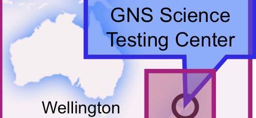
15 CSEP Testing Regions & Testing Centers Southern California Western Pacific SCEC Testing Center Global EU Testing Center Zurich China Testing Center ERI Testing Center Los Angeles California Italy North-South Seismic Belt Beijing Japan Tokyo GNS Science Testing Center Testing Center Upcoming Testing Region Upcoming Wellington New Zealand
16 CSEP Evaluation of Short-Term Models in the California Testing Region (Rhoades T-test, M 3) Southern California STEP Model Reference forecast IG = 2.6, PG = 13.5/eqk IG = 0.3, PG = 1.35/eqk Information gain per earthquake
17 The Consistency Problem Spatiotemporal consistency is an important issue for dynamic risk management, which often involves trade-offs among multiple targets and time frames In lieu of physics-based forecasting, consistency must be statistically enforced a challenge because: Long-term renewal models are less clustered than Poisson Short-term triggering models are more clustered than Poisson Consistency can be lacking if long-term forecasts specify background seismicity rates for the short-term models (e.g., STEP) Seismicity fluctuations introduced by earthquake triggering can occur on time scales comparable to the recurrence intervals of the largest events Model development needs to be integrated across all time scales of forecast applicability Approach adopted by WGCEP for development of UCERF3
18 The Valuation Problem Earthquake forecasts acquire value through their ability to influence decisions made by users seeking to mitigate seismic risk and improve community resilience to earthquake disasters Societal value of seismic safety measures based on long-term forecasts has been repeatedly demonstrated Potential value of protective actions that might be prompted by short-term forecasts is far less clear Benefits and costs of preparedness actions in high-gain, lowprobability situations have not been systematically investigated Previous work on the public utility of short-term forecasts has anticipated that they would deliver high probabilities of large earthquakes (deterministic prediction)
19 The Valuation Problem Economic valuation is one basis for prioritizing how to allocate the limited resources available for short-term preparedness In a low-probability environment, only low-cost actions are justified Cost-Benefit Analysis for Binary Decision-Making (e.g., van Stiphout et al., 2010) Suppose cost of protection against loss L is C < L. If the short-term earthquake probability is P, the policy that minimizes the expected expense E: - Protect if P > C/L - Do not protect if P < C/L Then, E = min {C, PL}. Many factors complicate this rational approach Monetary valuation of life, historical structures, etc. is difficult Valuation must account for information available in the absence of forecast Official actions can incur intangible costs (e.g., loss of credibility) and benefits (e.g., gains in psychological preparedness and resilience)
20 Recommendations Utilization of earthquake forecasts for risk mitigation and earthquake preparedness should comprise two basic components Scientific advisories expressed in terms of probabilities of threatening events Protocols that establish how probabilities can be translated into mitigation actions and preparedness Public sources of information on short-term probabilities should be authoritative, scientific, open, and timely Authoritative forecasts, even when the absolute probability is low, can provide a psychological benefit to the public by filling information vacuums that can lead to informal predictions and misinformation Should continuously inform the public about the seismic situation, in accordance with socialscience principles for effective public communication of warnings Need to convey the epistemic uncertainties in the operational forecasts Alert procedures should be standardized to facilitate decisions at different levels of government and among the public, based in part on objective analysis of costs and benefits Should also account for less tangible aspects of value-of-information, such as gains in psychological preparedness and resilience
21 Conclusions Southern California Current short-term forecasting methodologies can provide nominal (unvalidated) probability gains up to Issue: unification of methodologies across temporal and spatial scales Operational forecasting procedures should be qualified for usage according to three standards for operational fitness Quality: correspondence between the forecasts and actual earthquake behavior Consistency: compatibility of methods at different spatial or temporal scales Value: realizable benefits relative to costs incurred All operational forecasting models should be under continuous prospective testing Issue: evaluation of operational forecasts in terms of ground motions Governments should develop and maintain an open source of authoritative, scientific information about the short-term probabilities of future earthquakes keep the population aware of the current state of hazard decrease the impact of ungrounded information improve preparedness Issue: decision-making in a low-probability environment
22 How Should the Time-Dependent Forecasts be Communicated to Decision-Makers? Here here or here? Earthquake Rupture Forecast Attenuation Relationship Shaking Intensity Loss P(S n ) P(IM k S n ) P(IM k ) P(L k IM k ) Hazard Risk Probabilistic Seismic Hazard and Risk Analysis

23 Southern California STEP Map for 2004 Parkfield Earthquake + 1 hour Probability of Exceeding MMI VI
 Southern California Uses an extended earthquake rupture forecast Source area probabilities Hypocenter distributions (conditional) Slip variations (conditional) Uses reciprocity to calculate")
24 CyberShake 1.0 Hazard Model (225 sites in Los Angeles region, f < 0.5 Hz) Southern California Uses an extended earthquake rupture forecast Source area probabilities Hypocenter distributions (conditional) Slip variations (conditional) Uses reciprocity to calculate ground motions for ~440,000 events at each site Psuedo-dynamic fault rupture 3D anelastic model of wave propagation CyberShake seismogram LA region CyberShake hazard map PoE = 2% in 50 yrs Graves et al. (2010)
 Parkfield (M6.")
 Mar 24, 2009 Compute probability gain from Agnew & Jones (1991) model.")

25 CyberShake as a Platform for Short-Term Earthquake Forecasting Southern California (see poster by Milner et al., S51A-1926) Parkfield (M6.0) Sept 28, 2004 Parkfield, 2004 Los Angeles Bombay Beach, 2009 Bombay Beach (M4.8) Mar 24, 2009 Compute probability gain from Agnew & Jones (1991) model. Example: G = 1000 for R 10 km Apply probability gain to CyberShake ruptures and recompute ground motion probabilities for short interval following events. Example: 1 day
26 End Southern California
Southern California Earthquake Center Collaboratory for the Study of Earthquake Predictability (CSEP) Thomas H. Jordan
 Thomas H. Jordan") Southern California Earthquake Center Collaboratory for the Study of Earthquake Predictability (CSEP) Thomas H. Jordan SCEC Director & Professor, University of Southern California 5th Joint Meeting of
Southern California Earthquake Center Collaboratory for the Study of Earthquake Predictability (CSEP) Thomas H. Jordan SCEC Director & Professor, University of Southern California 5th Joint Meeting of
Operational Earthquake Forecasting: State of Knowledge and Guidelines for Utilization
 Operational Earthquake Forecasting: State of Knowledge and Guidelines for Utilization Report of the INTERNATIONAL COMMISSION ON EARTHQUAKE FORECASTING FOR CIVIL PROTECTION Thomas H. Jordan, chair International
Coping with natural risk in the XXI century: new challenges for scientists and decision makers
 Coping with natural risk in the XXI century: new challenges for scientists and decision makers Warner Marzocchi, Istituto Nazionale di Geofisica e Vulcanologia Outline The definition of hazard and risk
The Collaboratory for the Study of Earthquake Predictability: Perspectives on Evaluation & Testing for Seismic Hazard
 The Collaboratory for the Study of Earthquake Predictability: Perspectives on Evaluation & Testing for Seismic Hazard D. Schorlemmer, D. D. Jackson, J. D. Zechar, T. H. Jordan The fundamental principle
2014 SCEC Annual Meeting!
 2014 SCEC Annual Meeting! Palm Springs, California! 7-10 September 2014! Welcome Back to Palm Springs! AVAILABLE FOR DOWNLOAD http://www.scec.org/meetings/ 2014am/SCEC2014Program.pdf Goals of the Annual
Simulation-based Seismic Hazard Analysis Using CyberShake
 Simulation-based Seismic Hazard Analysis Using CyberShake SCEC CyberShake Collaboration: Robert Graves, Scott Callaghan, Feng Wang, Thomas H. Jordan, Philip Maechling, Kim Olsen, Kevin Milner, En-Jui Lee,
The Canterbury, NZ, Sequence
 The Canterbury, NZ, Sequence Complex: M7.1 Darfield (Sep 10) M6.2 Christchurch (Feb 11) M6.0 Christchurch (Jun 11) M5.9 Christchurch (Dec 11) Devastating: Over 180 deaths $10-15 billion USD Raised expected
Operational Earthquake Forecasting in Italy: perspectives and the role of CSEP activities
 Operational Earthquake Forecasting in Italy: perspectives and the role of CSEP activities Warner Marzocchi, Istituto Nazionale di Geofisica e Vulcanologia, Italy The research was developed partially within
2018 Blue Waters Symposium June 5, Southern California Earthquake Center
 Integrating Physics-based Earthquake Cycle Simulator Models and High-Resolution Ground Motion Simulations into a Physics-based Probabilistic Seismic Hazard Model PI: J. Vidale; Former PI: T. H. Jordan
A USGS Perspective on Earthquake Prediction Research
 A USGS Perspective on Earthquake Prediction Research Michael Blanpied USGS Earthquake Hazard Program Reston, VA USGS Statutory Role USGS Director has the delegated responsibility to issue warnings for
Collaboratory for the Study of Earthquake Predictability (CSEP)
") Collaboratory for the Study of Earthquake Predictability (CSEP) T. H. Jordan, D. Schorlemmer, S. Wiemer, M. Gerstenberger, P. Maechling, M. Liukis, J. Zechar & the CSEP Collaboration 5th International
Collaboratory for the Study of Earthquake Predictability (CSEP) T. H. Jordan, D. Schorlemmer, S. Wiemer, M. Gerstenberger, P. Maechling, M. Liukis, J. Zechar & the CSEP Collaboration 5th International
Time-varying and long-term mean aftershock hazard in Wellington
 Time-varying and long-term mean aftershock hazard in Wellington A. Christophersen, D.A. Rhoades, R.J. Van Dissen, C. Müller, M.W. Stirling, G.H. McVerry & M.C. Gerstenberger GNS Science, Lower Hutt, New
Wainui Beach Management Strategy (WBMS) Summary of Existing Documents. GNS Tsunami Reports
 Summary of Existing Documents. GNS Tsunami Reports") Wainui Beach Management Strategy (WBMS) Summary of Existing Documents GNS Tsunami Reports a) Review of Tsunami Hazard and Risk in New Zealand ( National Risk Report ) b) Review of New Zealand s Preparedness
Wainui Beach Management Strategy (WBMS) Summary of Existing Documents GNS Tsunami Reports a) Review of Tsunami Hazard and Risk in New Zealand ( National Risk Report ) b) Review of New Zealand s Preparedness
Opera'onal Earthquake Forecas'ng At the USGS
 Opera'onal Earthquake Forecas'ng At the USGS Coordina(ng Commi,ee: Michael Blanpied, Associate Earthquake Program Coordinator Lucy Jones, Science Advisor for Risk Reduc'on Andy Michael, Task leader for
From the Testing Center of Regional Earthquake Likelihood Models. to the Collaboratory for the Study of Earthquake Predictability
 From the Testing Center of Regional Earthquake Likelihood Models (RELM) to the Collaboratory for the Study of Earthquake Predictability (CSEP) Danijel Schorlemmer, Matt Gerstenberger, Tom Jordan, Dave
USC-SCEC/CEA Technical Report #1
 USC-SCEC/CEA Technical Report #1 Milestone 1A Submitted to California Earthquake Authority 801 K Street, Suite 1000 Sacramento, CA 95814 By the Southern California Earthquake Center University of Southern
Development of U. S. National Seismic Hazard Maps and Implementation in the International Building Code
 Development of U. S. National Seismic Hazard Maps and Implementation in the International Building Code Mark D. Petersen (U.S. Geological Survey) http://earthquake.usgs.gov/hazmaps/ Seismic hazard analysis
Eleventh U.S. National Conference on Earthquake Engineering Integrating Science, Engineering & Policy June 25-29, 2018 Los Angeles, California
 Eleventh U.S. National Conference on Earthquake Engineering Integrating Science, Engineering & Policy June 25-29, 2018 Los Angeles, California Site-Specific MCE R Response Spectra for Los Angeles Region
Operational Earthquake Forecasting
 Operational Earthquake Forecasting State of Knowledge and Guidelines for Utilization Report by the International Commission on Earthquake Forecasting for Civil Protection Submitted to the Department of
Quantifying the effect of declustering on probabilistic seismic hazard
 Proceedings of the Ninth Pacific Conference on Earthquake Engineering Building an Earthquake-Resilient Society 14-16 April, 2011, Auckland, New Zealand Quantifying the effect of declustering on probabilistic
ShakeAlert Earthquake Early Warning
 ShakeAlert Earthquake Early Warning Doug Given USGS, Pasadena Earthquake Program, Early Warning Coordinator 10 seconds 50 seconds 90 seconds USGS Earthquake Hazard Responsibilities USGS has the lead federal
10.1 A summary of the Virtual Seismologist (VS) method for seismic early warning
 method for seismic early warning") 316 Chapter 10 Conclusions This final Chapter is made up of the following: a summary of the Virtual Seismologist method for seismic early warning, comments on implementation issues, conclusions and other
316 Chapter 10 Conclusions This final Chapter is made up of the following: a summary of the Virtual Seismologist method for seismic early warning, comments on implementation issues, conclusions and other
Establishment and Operation of a Regional Tsunami Warning Centre
 Establishment and Operation of a Regional Tsunami Warning Centre Dr. Charles McCreery, Director NOAA Richard H. Hagemeyer Pacific Tsunami Warning Center Ewa Beach, Hawaii USA Why A Regional Tsunami Warning
Seismic Risk in California Is Changing
 WHITE PAPER 4 August 2016 Seismic Risk in California Is Changing The Impact of New Earthquake Hazard Models for the State Contributors: Paul C. Thenhaus Kenneth W. Campbell Ph.D Nitin Gupta David F. Smith
A GLOBAL MODEL FOR AFTERSHOCK BEHAVIOUR
 A GLOBAL MODEL FOR AFTERSHOCK BEHAVIOUR Annemarie CHRISTOPHERSEN 1 And Euan G C SMITH 2 SUMMARY This paper considers the distribution of aftershocks in space, abundance, magnitude and time. Investigations
National Earthquake Prediction Evaluation Council
 National Earthquake Prediction Evaluation Council Terry E. Tullis, Chair Emeritus and Research Professor Brown University Providence RI, 02912 1 What is NEPEC? From it s current (2010) Charter, the Scope
SCEC Simulation Data Access
 SCEC Simulation Data Access 16 February 2018 Philip Maechling (maechlin@usc.edu) Fabio Silva, Scott Callaghan, Christine Goulet, Silvia Mazzoni, John Vidale, et al. SCEC Data Management Approach SCEC Open
WESTERN STATES SEISMIC POLICY COUNCIL POLICY RECOMMENDATION Earthquake and Tsunami Planning Scenarios
 WESTERN STATES SEISMIC POLICY COUNCIL POLICY RECOMMENDATION 18-1 Earthquake and Tsunami Planning Scenarios Policy Recommendation 18-1 WSSPC strongly encourages states, provinces, territories, First Nations,
Barnabas Chipindu, Department of Physics, University of Zimbabwe
 DEFICIENCIES IN THE OPERATIONAL APPLICATIONS OF LONG - RANGE WEATHER PREDICTIONS FOR AGRICULTURE - RECOMMENDATIONS FOR IMPROVING THE TECHNOLOGY FOR THE BENEFIT OF AGRICULTURE AT THE NATIONAL AND REGIONAL
Probabilistic Tsunami Hazard Analysis. Hong Kie Thio AECOM, Los Angeles
 Probabilistic Tsunami Hazard Analysis Hong Kie Thio AECOM, Los Angeles May 18, 2015 Overview Introduction Types of hazard analysis Similarities and differences to seismic hazard Methodology Elements o
Publishable Summary. Summary Description of the project context and main objectives
 Publishable Summary Summary Description of the project context and main objectives Tsunamis are low frequency but high impact natural disasters. In 2004, the Boxing Day tsunami killed hundreds of thousands
Module 7 SEISMIC HAZARD ANALYSIS (Lectures 33 to 36)
") Lecture 34 Topics Module 7 SEISMIC HAZARD ANALYSIS (Lectures 33 to 36) 7.3 DETERMINISTIC SEISMIC HAZARD ANALYSIS 7.4 PROBABILISTIC SEISMIC HAZARD ANALYSIS 7.4.1 Earthquake Source Characterization 7.4.2
Lecture 34 Topics Module 7 SEISMIC HAZARD ANALYSIS (Lectures 33 to 36) 7.3 DETERMINISTIC SEISMIC HAZARD ANALYSIS 7.4 PROBABILISTIC SEISMIC HAZARD ANALYSIS 7.4.1 Earthquake Source Characterization 7.4.2
Tsunami Response and the Enhance PTWC Alerts
 Tsunami Response and the Enhance PTWC Alerts Ken Gledhill GeoNet Project Director Chair, Intergovernmental Coordination Group, Pacific Tsunami Warning and Mitigation System (PTWS) Overview 1. Procedures
Earthquakes. Earthquake Magnitudes 10/1/2013. Environmental Geology Chapter 8 Earthquakes and Related Phenomena
 Environmental Geology Chapter 8 Earthquakes and Related Phenomena Fall 2013 Northridge 1994 Kobe 1995 Mexico City 1985 China 2008 Earthquakes Earthquake Magnitudes Earthquake Magnitudes Richter Magnitude
AND STATEMENT OF EVIDENCE OF MATTHEW CHARLES GERSTENBERGER ON BEHALF OF THE CROWN AND CHRISTCHURCH CITY COUNCIL SEISMIC HAZARD MODELLING
 BEFORE THE CHRISTCHURCH REPLACEMENT DISTRICT PLAN INDEPENDENT HEARINGS PANEL IN THE MATTER of the Resource Management Act 1991 and the Canterbury Earthquake (Christchurch Replacement District Plan) Order
SCEC INCITE OLCF PROJECT PROGRESS REPORT,
 SCEC INCITE OLCF PROJECT PROGRESS REPORT, 2015 Title: PI and Co-PI(s): Thomas H. Jordan, Jacobo Bielak, Kim Olsen, Yifeng Cui, Po Chen, Ricardo Taborda, Philip Maechling Applying Institution/Organization:
3D Seismic Hazard and Risk Maps for Earthquake Awareness of Citizens with Aids of GIS and Remote Sensing Technologies
 3D Seismic Hazard and Risk Maps for Earthquake Awareness of Citizens with Aids of GIS and Remote Sensing Technologies Saburoh Midorikawa Tokyo Institute of Technology In Japan, seismic hazard and risk
SEISMIC HAZARD ANALYSIS. Instructional Material Complementing FEMA 451, Design Examples Seismic Hazard Analysis 5a - 1
 SEISMIC HAZARD ANALYSIS Instructional Material Complementing FEMA 451, Design Examples Seismic Hazard Analysis 5a - 1 Seismic Hazard Analysis Deterministic procedures Probabilistic procedures USGS hazard
ACCOUNTING FOR SITE EFFECTS IN PROBABILISTIC SEISMIC HAZARD ANALYSIS: OVERVIEW OF THE SCEC PHASE III REPORT
 ACCOUNTING FOR SITE EFFECTS IN PROBABILISTIC SEISMIC HAZARD ANALYSIS: OVERVIEW OF THE SCEC PHASE III REPORT Edward H FIELD 1 And SCEC PHASE III WORKING GROUP 2 SUMMARY Probabilistic seismic hazard analysis
2 Approaches To Developing Design Ground Motions
 2 Approaches To Developing Design Ground Motions There are two basic approaches to developing design ground motions that are commonly used in practice: deterministic and probabilistic. While both approaches
GEO-VIII November Geohazard Supersites and Natural Laboratories Progress Report. Document 9
 GEO-VIII 16-17 November 2011 Geohazard Supersites and Natural Laboratories Progress Report Document 9 This document is submitted to GEO-VIII for information. Geohazard Supersites and Natural Laboratories
Foreshocks, Aftershocks, and Earthquake Probabilities: Accounting for the Landers Earthquake
 Bulletin of the Seismological Society of America, Vol. 84, No. 3, pp. 892-899, June 1994 Foreshocks, Aftershocks, and Earthquake Probabilities: Accounting for the Landers Earthquake by Lucile M. Jones
RUPTURE MODELS AND GROUND MOTION FOR SHAKEOUT AND OTHER SOUTHERN SAN ANDREAS FAULT SCENARIOS
 RUPTURE MODELS AND GROUND MOTION FOR SHAKEOUT AND OTHER SOUTHERN SAN ANDREAS FAULT SCENARIOS ABSTRACT : L.A. Dalguer 1, S.M. Day 2, K. Olsen 3, and V.M. Cruz-Atienza 4 1 Institute of Geophysics, ETH-Zurich,
EARTHQUAKE HAZARD ASSESSMENT IN KAZAKHSTAN
 EARTHQUAKE HAZARD ASSESSMENT IN KAZAKHSTAN Dr Ilaria Mosca 1 and Dr Natalya Silacheva 2 1 British Geological Survey, Edinburgh (UK) imosca@nerc.ac.uk 2 Institute of Seismology, Almaty (Kazakhstan) silacheva_nat@mail.ru
DCPP Seismic FAQ s Geosciences Department 08/04/2011 GM1) What magnitude earthquake is DCPP designed for?
 What magnitude earthquake is DCPP designed for?") GM1) What magnitude earthquake is DCPP designed for? The new design ground motions for DCPP were developed after the discovery of the Hosgri fault. In 1977, the largest magnitude of the Hosgri fault was
GM1) What magnitude earthquake is DCPP designed for? The new design ground motions for DCPP were developed after the discovery of the Hosgri fault. In 1977, the largest magnitude of the Hosgri fault was
Southern California Earthquake Center. SCEC Annual Meeting. Palm Springs, California September 2016
 SCEC Annual Meeting Palm Springs, California 11-14 September 2016 Welcome to Palm Springs! Southern California SCEC Annual Meetings 707 pre-registrants 347 poster abstracts 211 first-time attendees (145
VALIDATION AGAINST NGA EMPIRICAL MODEL OF SIMULATED MOTIONS FOR M7.8 RUPTURE OF SAN ANDREAS FAULT
 VALIDATION AGAINST NGA EMPIRICAL MODEL OF SIMULATED MOTIONS FOR M7.8 RUPTURE OF SAN ANDREAS FAULT L.M. Star 1, J. P. Stewart 1, R.W. Graves 2 and K.W. Hudnut 3 1 Department of Civil and Environmental Engineering,
UCERF3 Task R2- Evaluate Magnitude-Scaling Relationships and Depth of Rupture: Proposed Solutions
 UCERF3 Task R2- Evaluate Magnitude-Scaling Relationships and Depth of Rupture: Proposed Solutions Bruce E. Shaw Lamont Doherty Earth Observatory, Columbia University Statement of the Problem In UCERF2
Update on the It s Our Fault project
 Report 12.552 Date 29 October 2012 File 12/01/01 Committee Author CDEM Group Bruce Pepperell, Regional Manager, WREMO Update on the It s Our Fault project 1. Purpose To inform the CDEM Group of progress
New USGS Maps Identify Potential Ground- Shaking Hazards in 2017
 New USGS Maps Identify Potential Ground- Shaking Hazards in 2017 New USGS Maps Identify Potential Ground-Shaking Hazards in 2017 The central U.S. faces continued hazards from human-induced earthquakes
#13 Earthquake Prediction
 #13 Earthquake Prediction Obvious importance Earthquake Prediction Save lives, reduce damage Earthquake Prediction - Types Long-range prediction - involves EQ probability over long time period (years to
Geotechnical Earthquake Engineering
 Geotechnical Earthquake Engineering by Dr. Deepankar Choudhury Humboldt Fellow, JSPS Fellow, BOYSCAST Fellow Professor Department of Civil Engineering IIT Bombay, Powai, Mumbai 400 076, India. Email: dc@civil.iitb.ac.in
Assessment and Mitigation of Ground Motion Hazards from Induced Seismicity. Gail M. Atkinson
 Assessment and Mitigation of Ground Motion Hazards from Induced Seismicity Gail M. Atkinson (with acknowledgement to many collaborators, especially Ghofrani and Assatourians) NSERC/TransAlta/Nanometrics
Aftershock From Wikipedia, the free encyclopedia
 Page 1 of 5 Aftershock From Wikipedia, the free encyclopedia An aftershock is a smaller earthquake that occurs after a previous large earthquake, in the same area of the main shock. If an aftershock is
Article from: Risk Management. March 2009 Issue 15
 Article from: Risk Management March 2009 Issue 15 XXXXXXXXXXXXX RISK IDENTIFICATION Preparing for a New View of U.S. Earthquake Risk By Prasad Gunturi and Kyle Beatty INTRODUCTION The United States Geological
ShakeOut-D: Ground motion estimates using an ensemble of large earthquakes on the southern San Andreas fault with spontaneous rupture propagation
 Click Here for Full Article GEOPHYSICAL RESEARCH LETTERS, VOL. 36, L04303, doi:10.1029/2008gl036832, 2009 ShakeOut-D: Ground motion estimates using an ensemble of large earthquakes on the southern San
GEO Geohazards Community of Practice
 GEO Geohazards Community of Practice 1) Co-Chair of GHCP With input from: Stuart Marsh, GHCP Co-Chair Francesco Gaetani, GEO Secretariat and many GHCP contributors 1) Nevada Bureau of Mines and Geology
I. Locations of Earthquakes. Announcements. Earthquakes Ch. 5. video Northridge, California earthquake, lecture on Chapter 5 Earthquakes!
 51-100-21 Environmental Geology Summer 2006 Tuesday & Thursday 6-9:20 p.m. Dr. Beyer Earthquakes Ch. 5 I. Locations of Earthquakes II. Earthquake Processes III. Effects of Earthquakes IV. Earthquake Risk
Indian Ocean Tsunami Warning System: Example from the 12 th September 2007 Tsunami
 Indian Ocean Tsunami Warning System: Example from the 12 th September 2007 Tsunami Charitha Pattiaratchi 1 Professor of Coastal Oceanography, The University of Western Australia Email: chari.pattiaratchi@uwa.edu.au
Usually, only a couple of centuries of earthquake data is available, much shorter than the complete seismic cycle for most plate motions.
 Earthquake Hazard Analysis estimate the hazard presented by earthquakes in a given region Hazard analysis is related to long term prediction and provides a basis to expressed hazard in probabilistic terms.
The Uniform California Earthquake Rupture Forecast, Version 3 (UCERF3) Project Plan
 Project Plan") UCERF3_Project_Plan_v55.doc 1 The Uniform California Earthquake Rupture Forecast, Version 3 (UCERF3) Project Plan by the Working Group on California Earthquake Probabilities (WGCEP) Notes on this version
UCERF3_Project_Plan_v55.doc 1 The Uniform California Earthquake Rupture Forecast, Version 3 (UCERF3) Project Plan by the Working Group on California Earthquake Probabilities (WGCEP) Notes on this version
KNOWLEDGE NOTE 5-1. Risk Assessment and Hazard Mapping. CLUSTER 5: Hazard and Risk Information and Decision Making. Public Disclosure Authorized
 Public Disclosure Authorized Public Disclosure Authorized Public Disclosure Authorized Public Disclosure Authorized KNOWLEDGE NOTE 5-1 CLUSTER 5: Hazard and Risk Information and Decision Making Risk Assessment
San Francisco Bay Area Earthquake Simulations: A step toward a Standard Physical Earthquake Model
 San Francisco Bay Area Earthquake Simulations: A step toward a Standard Physical Earthquake Model Steven N. Ward Institute of Geophysics and Planetary Physics, University of California, Santa Cruz, CA,
The Uniform California Earthquake Rupture Forecast, Version 3 (UCERF3) Project Plan
 Project Plan") UCERF3_Project_Plan_v39.doc 1 The Uniform California Earthquake Rupture Forecast, Version 3 (UCERF3) Project Plan by the Working Group on California Earthquake Probabilities (WGCEP) Notes: This version
UCERF3_Project_Plan_v39.doc 1 The Uniform California Earthquake Rupture Forecast, Version 3 (UCERF3) Project Plan by the Working Group on California Earthquake Probabilities (WGCEP) Notes: This version
Shaking Down Earthquake Predictions
 Shaking Down Earthquake Predictions Department of Statistics University of California, Davis 25 May 2006 Philip B. Stark Department of Statistics University of California, Berkeley www.stat.berkeley.edu/
Lessons Learned from Past Tsunamis Warning and Emergency Response
 UNESCO IOC CTIC US NOAA ITIC Regional Training Workshop on Strengthening Tsunami Warning and Emergency Response Standard Operating Procedures and the Development of the ICG/CARIBE-EWS PTWC New Enhanced
New Zealand s Next Top Model: integrating tsunami modelling into land use planning
 New Zealand s Next Top Model: integrating tsunami modelling into land use planning Wendy Saunders (MZNZPI), Gegar Prasetya, Graham Leonard GNS Science, Lower Hutt, w.saunders@gns.cri.nz In April 2011 a
Bringing Renewables to the Grid. John Dumas Director Wholesale Market Operations ERCOT
 Bringing Renewables to the Grid John Dumas Director Wholesale Market Operations ERCOT 2011 Summer Seminar August 2, 2011 Quick Overview of ERCOT The ERCOT Market covers ~85% of Texas overall power usage
Treatment of Epistemic Uncertainty in PSHA Results
 Treatment of Epistemic Uncertainty in PSHA Results Norm Abrahamson University of California, Berkeley Pacific Gas & Electric PSHA Workshop, Lenzburg, Switzerland, Sep 7, 2017 Haz(GM > z)= Nscenarios i=1
Project 17 Development of Next-Generation Seismic Design Value Maps
 Project 17 Development of Next-Generation Seismic Design Value Maps Geo Structures 2016 16 February 2016 R.O. Hamburger, SE, SECB www.sgh.com Some History Prior to 1988 - maps provided broad seismic zones
Modelling Strong Ground Motions for Subduction Events in the Wellington Region, New Zealand
 Proceedings of the Ninth Pacific Conference on Earthquake Engineering Building an Earthquake-Resilient Society 14-16 April, 2011, Auckland, New Zealand Modelling Strong Ground Motions for Subduction Events
Validation of Earthquake Simulations and Their Effects on Tall Buildings Considering Spectral Shape and Duration
 Validation of Earthquake Simulations and Their Effects on Tall Buildings Considering Spectral Shape and Duration SCEC Annual Meeting 2013 Ting Lin Marquette University Greg Deierlein Nenad Bijelic Stanford
Characteristics and introduction of Earthquake in Asia-Pacific region
 Characteristics and introduction of Earthquake in Asia-Pacific region 1906 San Francisco 2011 Tohoku 1999 Chi-Chi 1985 Mexico City 2004 Sumatra Chung-Han Chan 詹忠翰 2011 Christchurch To understand the characteristics
Ivan Wong Seismic Hazards Group AECOM Oakland, CA. IEAGHG Monitoring Network Meeting. 10 June 2015
 Protocol and Best Practices for Addressing Induced Seismicity Associated With Enhanced Geothermal Systems (EGS) Ernie Majer Lawrence Berkeley National Laboratory Berkeley, CA and Ivan Wong Seismic Hazards
A METHODOLOGY FOR ASSESSING EARTHQUAKE-INDUCED LANDSLIDE RISK. Agency for the Environmental Protection, ITALY (
 A METHODOLOGY FOR ASSESSING EARTHQUAKE-INDUCED LANDSLIDE RISK Roberto W. Romeo 1, Randall W. Jibson 2 & Antonio Pugliese 3 1 University of Urbino, ITALY (e-mail: rwromeo@uniurb.it) 2 U.S. Geological Survey
Chapter 2 Land Use Management and Risk Communication
 Chapter 2 Land Use Management and Risk Communication Michiko Banba Abstract Land use represents a relationship between natural and urban environment. Land use management is the way of managing land use
A TESTABLE FIVE-YEAR FORECAST OF MODERATE AND LARGE EARTHQUAKES. Yan Y. Kagan 1,David D. Jackson 1, and Yufang Rong 2
 Printed: September 1, 2005 A TESTABLE FIVE-YEAR FORECAST OF MODERATE AND LARGE EARTHQUAKES IN SOUTHERN CALIFORNIA BASED ON SMOOTHED SEISMICITY Yan Y. Kagan 1,David D. Jackson 1, and Yufang Rong 2 1 Department
MONTE CARLO SIMULATION RISK ANALYSIS AND ITS APPLICATION IN MODELLING THE INCLEMENT WEATHER FOR PROGRAMMING CIVIL ENGINEERING PROJECTS
 MONTE CARLO SIMULATION RISK ANALYSIS AND ITS APPLICATION IN MODELLING THE INCLEMENT WEATHER FOR PROGRAMMING CIVIL ENGINEERING PROJECTS Pedram Daneshmand Associate Director Blue Visions Management (bluevisions)
CHARACTERIZING SPATIAL CROSS-CORRELATION BETWEEN GROUND- MOTION SPECTRAL ACCELERATIONS AT MULTIPLE PERIODS. Nirmal Jayaram 1 and Jack W.
 Proceedings of the 9th U.S. National and 10th Canadian Conference on Earthquake Engineering Compte Rendu de la 9ième Conférence Nationale Américaine et 10ième Conférence Canadienne de Génie Parasismique
Application of a GIS for Earthquake Hazard Assessment and Risk Mitigation in Vietnam
 Application of a GIS for Earthquake Hazard Assessment and Risk Mitigation in Vietnam Nguyen Hong Phuong Earthquake Information and Tsunami Warning Centre, VAST OUTLINE Introduction Fault Source Model and
METEOROLOGICAL WARNINGS STUDY GROUP (METWSG)
") METWSG/4-SN No. 6 12/3/12 METEOROLOGICAL WARNINGS STUDY GROUP (METWSG) FOURTH MEETING Montréal, 15 to 18 May 2012 Agenda Item 6: Wind shear, turbulence and tsunami warnings TSUNAMI INFORMATION (Presented
METWSG/4-SN No. 6 12/3/12 METEOROLOGICAL WARNINGS STUDY GROUP (METWSG) FOURTH MEETING Montréal, 15 to 18 May 2012 Agenda Item 6: Wind shear, turbulence and tsunami warnings TSUNAMI INFORMATION (Presented
158 Reducing Earthquake Losses
 ndex A Accelerographs, 64 Active control systems, 83-84 Active mass damping, 83 Active tendons, 83 Advocates, role of, 116 Air Force Office of Scientific Research, 133 Alaska, 42-43 Alquist-Priolo Act,
Landslide Hazard Assessment Methodologies in Romania
 A Scientific Network for Earthquake, Landslide and Flood Hazard Prevention SciNet NatHazPrev Landslide Hazard Assessment Methodologies in Romania In the literature the terms of susceptibility and landslide
Earthquake early warning: Adding societal value to regional networks and station clusters
 Earthquake early warning: Adding societal value to regional networks and station clusters Richard Allen, UC Berkeley Seismological Laboratory rallen@berkeley.edu Sustaining funding for regional seismic
 This article was published in an Elsevier journal. The attached copy is furnished to the author for non-commercial research and education use, including for instruction at the author s institution, sharing
WMO/WWRP FDP: INCA CE
 WMO/WWRP FDP: INCA CE Yong Wang ZAMG, Austria This project is implemented through the CENTRAL EUROPE Programme co-financed by the ERDF INCA CE: implementation over Central Europe A Nowcasting Initiative
By Lillian Ntshwarisang Department of Meteorological Services Phone:
 By Lillian Ntshwarisang Department of Meteorological Services Phone: +267 3612200 Email: lntshwarisang@gov.bw/ lntshwarisang@gmail.com Introduction Mandate of DMS Function of the Department Services to
INCA-CE achievements and status
 INCA-CE achievements and status Franziska Strauss Yong Wang Alexander Kann Benedikt Bica Ingo Meirold-Mautner INCA Central Europe Integrated nowcasting for the Central European area This project is implemented
RISK ANALYSIS AND RISK MANAGEMENT TOOLS FOR INDUCED SEISMICITY
 Eleventh U.S. National Conference on Earthquake Engineering Integrating Science, Engineering & Policy June 25-29, 2018 Los Angeles, California RISK ANALYSIS AND RISK MANAGEMENT TOOLS FOR INDUCED SEISMICITY
Earthquake Hazards in Henderson
 Earthquake Hazards in Henderson Craig M. depolo Nevada Bureau of Mines and Geology Nevada Hazard Mitigation Planning Committee November 15, 2012 Earthquake Truths The consequences of bad earthquakes to
JCOMM-CHy Coastal Inundation Forecasting Demonstration Project (CIFDP)
") WMO World Meteorological Organization Working together in weather, climate and water JCOMM-CHy Coastal Inundation Forecasting Demonstration Project (CIFDP) Coastal Flooding & Vulnerable Populations Coastal
WMO World Meteorological Organization Working together in weather, climate and water JCOMM-CHy Coastal Inundation Forecasting Demonstration Project (CIFDP) Coastal Flooding & Vulnerable Populations Coastal
DISCLAIMER BIBLIOGRAPHIC REFERENCE
 DISCLAIMER This report has been prepared by the Institute of Geological and Nuclear Sciences Limited (GNS Science) exclusively for and under contract to the Earthquake Commission. Unless otherwise agreed
ShakeAlert Phase 1: West Coast Earthquake Early Warning. Doug Given, USGS EEW Coordinator Education Symposium, Dec. 4, 2018
 ShakeAlert Phase 1: West Coast Earthquake Early Warning Doug Given, USGS EEW Coordinator Education Symposium, Dec. 4, 2018 Population WA 7M OR 4M Annualized Earthquake Losses, $6.1B 61% in California,
Todd N. Loar, PG, CEG
 1 USACE DAM RISK ASSESSMENT PROGRAM OVERVIEW AND HOW ENGINEERING GEOLOGY CONTRIBUTES TO THE LEVEL OF CONFIDENCE AND RESULTS 255 255 255 237 237 237 217 217 217 200 200 200 0 0 0 163 163 163 131 132 122
e-science on Earthquake Disaster Mitigation in Taiwan
 e-science on Earthquake Disaster Mitigation in Taiwan Eric Yen EGI User Forum, April 2011 ~50 earthquakes/day Taiwan Seismicity on Google Earth 0 15 30 70 100 150 km Eurasia Plate S01R Philippine Sea Plate
Short-Term Earthquake Forecasting Using Early Aftershock Statistics
 Bulletin of the Seismological Society of America, Vol. 101, No. 1, pp. 297 312, February 2011, doi: 10.1785/0120100119 Short-Term Earthquake Forecasting Using Early Aftershock Statistics by Peter Shebalin,
(Seismological Research Letters, July/August 2005, Vol.76 (4): )
: )") (Seismological Research Letters, July/August 2005, Vol.76 (4):466-471) Comment on How Can Seismic Hazard around the New Madrid Seismic Zone Be Similar to that in California? by Arthur Frankel Zhenming
(Seismological Research Letters, July/August 2005, Vol.76 (4):466-471) Comment on How Can Seismic Hazard around the New Madrid Seismic Zone Be Similar to that in California? by Arthur Frankel Zhenming
Model Uncertainties of the 2002 Update of California Seismic Hazard Maps
 Bulletin of the Seismological Society of America, Vol. 95, No. 6, pp. 24 257, December 25, doi: 1.1785/12517 Model Uncertainties of the 22 Update of California Seismic Hazard Maps by Tianqing Cao, Mark
UC Berkeley Berkeley Scientific Journal
 UC Berkeley Berkeley Scientific Journal Title Earthquakes Induced by Stress Permalink https://escholarship.org/uc/item/3br5k87m Journal Berkeley Scientific Journal, 18(1) ISSN 2373-8146 Author Singh, Harjit
CyberShake: A Physics-Based Seismic Hazard Model for Southern California
 Pure Appl. Geophys. Ó 2010 Springer Basel AG DOI 10.1007/s00024-010-0161-6 Pure and Applied Geophysics CyberShake: A Physics-Based Seismic Hazard Model for Southern California ROBERT GRAVES, 1 THOMAS H.