KARAGIANNIDIS A.F.1, 2, * TRIANTAFYLLOU A.G.1 KARACOSTAS T.S. 2
|
|
|
- Rebecca Russell
- 5 years ago
- Views:
Transcription

1 Global NEST Journal, Vol 15, No 2, pp , 2013 Copyright 2013 Global NEST Printed in Greece. All rights reserved ANALYZING THE BASIC METEOROLOGICAL ASPECTS OF A PARTICULATE AIR POLLUTION EPISODE OVER THE INDUSTRIAL AREA OF NORTHWESTERN GREECE DURING THE NOVEMBER 2009 KARAGIANNIDIS A.F.1, 2, * TRIANTAFYLLOU A.G.1 KARACOSTAS T.S. 2 Received: 27/11/12 Accepted: 17/05/13 1 Laboratory of Atmospheric Pollution and Environmental Physics, School of Technological Applications, TEI of Western Macedonia, Kozani, Greece 2 Department of Meteorology and Climatology, School of Geology, A.U.Th., Thessaloniki, Greece *to whom all correspondence should be addressed: thankar@live.com ABSTRACT The complex terrain basin of Amyntaio Ptolemais Kozani in Western Macedonia of Greece is an area characterized by increased industrial activity and therefore it demands continuous and assiduous environmental monitoring. A prolonged particulate matter air pollution episode was recorded in the area during November Basic meteorological aspects are analyzed, during the episode period. Daily and hourly PM10 and PM2.5 concentration measurements were used along with surface and lower atmosphere hourly meteorological parameters from 13 measuring stations. The observational data were supported by data produced by the meteorological component of an air pollution model. The overall analysis showed that the episode was primarily the result of the synoptic setting of the middle and lower troposphere. An Omega blocking pattern which gradually transformed to a highover-low pattern prevailed over central and southern Europe during the episode s period. The examination of the vertical wind field in the lower troposphere and appropriate stability indices, revealed a continuous absence of significant convection. The weak horizontal wind field near the surface and the reduced mixing height combined with the lack of synoptic forcing resulted in the trapping of the pollutants in the lower troposphere and the recording of increased airborne particulate matter concentrations. The radical change of the synoptic setting in the first days of December marked the end of the episode. KEYWORDS: stability, particulate matter, Omega block, high-over-low. INTRODUCTION Western Macedonia in Greece and especially the complex terrain basin of Amyntaio Ptolemais Kozani (BAPK), hosts a considerable number of Power Stations (PS) facilities along with lignite mines that feed these PSs. As a result, the air quality of the area is significantly affected due to the large amounts of airborne particulate matter (PM) emitted by those facilities (Triantafyllou 2003). The thorough and precise analysis of any possible relations between the meteorological conditions and the atmospheric pollution may help to successfully forecast extreme air pollution episodes, providing the necessary time and information to prepare for, or even avoid them. Significant work has been carried out in the subject around the globe. McKendry (2000) investigated the meteorological parameters affecting the PM10 levels in the Lower Fraser Valley, British Columbia in Canada, while Rodríguez et al. (2002) examined the origin of high summer PM10 and TSP (Total Suspended Particles) concentrations at rural sites in Eastern Spain, concluding amongst others, that breeze circulations are partly responsible for these extreme events. The dependence of urban air pollutants on meteorology in the area of Cairo was analyzed by Elminir (2005). It was shown that wind and humidity affected the concentration and speciation of the pollutants. Barbadimos et al. (2011) examined the possible influence of meteorology on PM10 trends and
2 242 KARAGIANNIDIS et al. variability in Switzerland from 1991 to 2008 and indicated that wind and temperature are two of the most significant factors. In Greece, many researchers have already addressed the problem. Kallos et al. (1993) studied a series of air pollution episodes in Athens during the period concluding that days with critical balance between synoptic and mesoscale circulations and/or days of warm advection in the lower troposphere favor such episodes. Triantafyllou (2001) studied high PM10 concentration episodes in Eordea valley and showed that stagnant meteorological conditions are most frequently associated with these episodes. Flocas et al. (2009) concluded amongst others, that air pollution episodes in the Thessaloniki area are primarily associated with anticyclonic conditions, small temperature rise and sea breeze circulation. Larissi et al. (2010), studied the temporal and spatial distribution of the Air Quality Index (AQI) within greater Athens area (GAA) and showed that the higher values of the index (high AQI values are generally associated to high concentrations of specific pollutants) during the warm period of the year, are strongly associated with sea breeze. This association was also noted by Proias et al. (2012) in the Greek city of Volos. The meteorological setting of a particulate air pollution episode during November 2009 is investigated in the present paper. The episode is identified by means of particulate matter concentration values in specific sites along the BAPK axis. The data used are: a) mean daily PM10 and PM2.5 concentrations from the atmospheric pollution stations network of the Greek Public Power Corporation (PPC) and the Laboratory of Atmospheric Pollution and Environmental Physics of the School of Technological Applications of TEI of Western Macedonia, b) operational ECMWF analyses data, c) soundings data and d) vertical profiles of the basic meteorological parameters, produced by a prognostic local scale meteorological model. THE AREA The BAPK is situated in a mountainous area of western Macedonia, Greece. It presents a NW to SE orientation, with Amyntaio at the north and Kozani at the south end. Figure 1 depicts a topographic map of the area, the 13 measuring stations (1. Kato Komi, 2. Petrana, 3. Kozani, 4. Koilada, 5. Oikismos B, 6. Pontokomi, 7. Mavropigi, 8. Oikismos A, 9. Pentavrisos, 10. Anargiroi, 11. Amyntaio, 12. Vevi, 13. Florina) and the 6 power plants sites (PS1. Agios Dimitrios, PS2. Kardia, PS3. Ptolemaida, PS4. Amyntaio, PS5. Meliti, PS6. Bitola). DATA AND METHODOLOGY Hourly observational data from stations belonging to the Greek Public Power Corporation (PPC) and to the Laboratory of Atmospheric Pollution and Environmental Physics of the School of Technological Applications of TEI of Western Macedonia are one of the primary data sets used. These data include surface wind speed and direction and PM10 and PM2.5 concentration measurements, extending from 1/11/2009 to 30/12/2009. Based on the hourly observations, mean daily values are also computed. Daily PM10 values for November and December from 2006 to 2009 have also been used. Operational ECMWF analysis data of horizontal resolution of 0.25x0.25 degrees and temporal resolution of 6 hours, at all the basic pressure levels, are used to produce the required synoptic charts by means of Grid Analysis and Display System (GrADS). The Mean Sea Level Pressure (MSLP) and the 500hPa geopotential height fields are examined to define the synoptic conditions of the episode. The vertical wind velocity at the 700hPa level is used to identify possible synoptic forcing in the area. The meteorological component of The Air Pollution Model (TAPM) is also used to produce hourly vertical profiles of specific atmospheric parameters like temperature, potential temperature, wind speed and direction and other useful variables like the mixing height for selected sites of the area. The Air Pollution Model (TAPM) is a PC-based, nestable, prognostic meteorological and air pollution model driven by a Graphical User Interface (GUI). The GUI allows the user to configure inputs, run the model and analyze outputs generated by the model. It is linked to databases of terrain height, land use, and sea surface temperature information. Data sets of synoptic scale meteorology inputs needed for simulation accompany the model. More details on TAPM equations and parameterizations, including the numerical methods used to solve the model equations, can be found in Hurley (1997), Hurley (2002a), Hurley et al. (2001), Hurley et al. (2005), while the model application in W. Macedonia region in Zoras et al. (2007) and Triantafyllou et al. (2011). The meteorological component of TAPM is an incompressible, non-hydrostatic, primitive equation model with a terrain following vertical coordinate for three-dimentional simulations. It includes

3 ANALYZING THE BASIC METEOROLOGICAL ASPECTS 243 parameterizations for cloud micro-physical process, turbulence closure, vegetative canopy and soil, and radiative fluxes. The mean horizontal wind components u and v are determined from the momentum equations and the terrain following vertical velocity from the continuity equation. Potential virtual temperature θ is determined from an equation combining conservation of heat and water vapor. Pressure is determined from the sum of hydrostatic and optional non-hydrostatic component. The boundary-layer height (Zmix) in convective conditions is defined as the first model level above the surface for which the updraft velocity decreases to zero, while in stable/neutral conditions it is defined as the first model level above the surface that has a vertical heat flux less than 5% of the surface value following Derbyshire (1990). More details about that can be found in Hurley (2008). Micro-physics is based on Katzfey and Ryan (1997) for warm rain, and include bulk parameterizations for condensation of water vapor, evaporation of cloud water and rain water, autoconversion and collection of cloud water to form rain water and an expression for the rainfall terminal velocity. The meteorological component of the model is nested within synoptic-scale analyses/forecasts that drive the model at the boundaries of the outer grid. The model is initialized at each grid point values of u, v, θ, q interpolated from the synoptic analyses. At the model top boundary, all variables are set at their synoptic values, while zero gradient boundary conditions are used for all variables at the lateral boundaries. The model run for a twenty days period (15/115/12/2009) using 25 vertical model levels, and three nested domains of 35x35 horizontal grid points at 30, 10 and 3 Km spacing for the meteorology. NCEP synoptic analyses were used at the outer grid boundaries. Pontokomi was considered as the center (0,0,0). Sounding data from the nearest sounding station (Thessaloniki) are used, mainly to determine the presence of vertical forcing through the examination of stability indices such as the Total Totals Index (TTI) (Miller, 1967), the Lifted Index (LI) (Galway, 1956; Blanchard, 1998), the K-Index (KI) (George, 1960) and the Showalter Index (SI) (Showalter, 1953). TTI values over 44 are associated with convective activity that increases as the index values increase. Values over 55 indicate very strong instability. LI values between -2 and -6 are indicative of convective potential while values below -6 are associated with very strong convection. SI values between 3 and -3 indicate possibility of showers and thunderstorms and values below -3 are indicative of very strong convective activity. Finally, KI values over 20 suggest possible convective activity, while values over 40 imply certainty of convection. Figure 1. The study area. Measuring stations (1, 2, 3,, 13) and power plants sites (PS1, PS2,, PS6) RESULTS The definition of the exact time period of the episode is not a straightforward task, due to the diversity of the measuring sites. Daily PM10 mean values from November of 2006 to November of 2009 are used to calculate the November PM10 threshold daily value of the upper 25% of the distribution, for each measuring site. Any day with mean PM10 value exceeding this value is considered to be part of the episode.


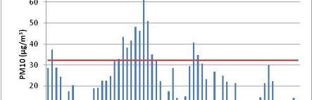

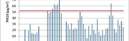


4 244 KARAGIANNIDIS et al. Figure 2. Daily PM10 concentration values, for all the available measuring stations. The red line indicates the PM10 threshold daily value of the upper 25% of the distribution
5 ANALYZING THE BASIC METEOROLOGICAL ASPECTS 245 Figure 2 (continued). Daily PM10 concentration values, for all the available measuring stations. The red line indicates the PM10 threshold daily value of the upper 25% of the distribution The studied episode starts at the 14th of November for some of the stations and ends after the 25th, showing a peak between the 22nd and the 24th of November. The exact length depends on the measuring station. This is illustrated in Figure 2, where the time evolution of the daily average PM10 concentration for all the measuring sites is depicted. The threshold value of the upper 25% of the distribution is also shown as a continuous horizontal line (daily values for the station of Oikismos B for the period were not available). In order to avoid falsely excluding part of the episode, it is considered to extend from the 14th to the end of November of The synoptic setting over the examined area is investigated based on MSLP and 500hPa synoptic charts. Southern Europe is dominated by an Omega block (Huschke 1959, Karacostas et al. 2006) from 17/11 to 20/11 as it can be seen in Figures 3a and 3b. During the 21st and 22nd the Omega block gradually transforms to a high-over-low pattern (Figure 3c) that lasts until the night of the 23rd of November. At the afternoon of the 24th (Figure 3d) a short wave embedded on the almost stagnant long wave passes over Western Macedonia and reinforces temporarily the surface wind field. Another short wave passes over the area during the afternoon of the 28 th (Figure 3e) causing light rainfall. A trough associated to a deep depression, approaches Greece during the 1st of December (Figure 3f) establishing a strong southeasterly flow and producing significant rainfall in western Macedonia during the 1st and 2nd of December.
 (b) (c) (d) (e) (f)")


 and")


 until the first days")
6 246 KARAGIANNIDIS et al. (a) (b) (c) (d) (e) (f) Figure 3. Geopotential height (in gpm) at the 500 hpa level during significant time instances of the episode Due to the Omega block that dominates the area, MSLP and therefore the associated surface wind field, is quite weak (Figure 4a), strengthening during the passing of the first short wave on the 25 th of November (Figure 4b). The horizontal wind field in the lower troposphere weakens again during the 26th of November (Figure 4c) and strengthens again due to the second short wave of the 28th (Figure 4d). The approach of the trough preserves the strong surface horizontal wind (Figure 4e) until the first days of December when the depression reaches the examined area (Figure 4f).
 (d) (e) (f) Figure 4.")


,")

7 ANALYZING THE BASIC METEOROLOGICAL ASPECTS 247 (a) (b) (c) (d) (e) (f) Figure 4. MSLP (in hpa) during significant time instances of the episode The significant strengthening of the horizontal surface wind field, directly associated to the passing of the two shortwaves, is confirmed by the model s outputs, as can be seen in the Figure 5. During days of week synoptic surface pressure field like the 22th of November (Figure 5a and 5b), the horizontal surface wind is also very week and is formulated mainly by the local circulation patterns. The passing of the upper air shortwaves on the 25th and the 28th of November increases significantly the surface wind speed and homogenizes the surface wind direction (Figures 5c and 5d respectively). Lack of significant synoptic forcing during the days of the episode is revealed through the investigation of the omega vertical velocity in the pressure level of 700 hpa. As can be seen in Figure 6a the area is dominated by week vertical motions that are usually less than 10 hpa h-1, even in the warm hours of the day. The passing of the first short wave during the afternoon of the 24 th does not change the situation significantly (Figure 6b), but the shortwave of the 28 th strengthens the vertical motions (Figure 6c), resulting in light rainfall. The vertical wind field weakens again during the following hours (Figure 6d), until the arrival of the depression during the first days of December when increased vertical wind velocity is recorded in the area (Figure 6e).


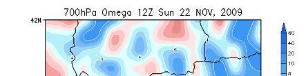


8 248 KARAGIANNIDIS et al. (a) (b) (d) (c) Figure 5. Surface wind field simulations during significant time instances of the episode (a) (b) Figure 6. The vertical velocity field (in hpa h-1) during significant time instances of the episode
 during significant time instances of the episode An almost constant increase of PM10 and PM2.")
. An analogous decrease of PM2.")


9 ANALYZING THE BASIC METEOROLOGICAL ASPECTS 249 (c) (d) (e) Figure 6 (continued). The vertical velocity field (in hpa h-1) during significant time instances of the episode An almost constant increase of PM10 and PM2.5 concentrations is recorded as the surface wind remains weak. During the 25th of November when the wind field strengthens temporarily, PM10 values at Pentavrisos drop significantly. The same pattern appears after the 28 th of November when the wind field presents another significant increase (Figure 7a). An analogous decrease of PM2.5 concentrations values is recorded at Oikismos A, following the significant strengthening of surface wind after the 27th of November (Figure 7b). Hourly mixing height values are calculated by TAPM at various sites. Figure 8 shows the diurnal variation of this parameter from 15th to 30th of November at Pentavrisos and Oikismos A. Low mixing height values are recorded during most hours of the days, increasing only around midday. Moreover, a gradual decrease of the top of the mixing height until 22nd of November is recorded. Another significant feature is the increased mixing height during the last hours of the 25th and the first ones of the 26th of November, that may be partially associated to the intensified vertical motions in the area. (a) (b) Figure 7. (a) Wind speed (m s-1) and PM10 (μg m-3) hourly values at Pentavrisos (Fig.1, measuring station 9) and, (b) Wind speed (m s-1) and PM2.5 (μg m-3) hourly values at Oikismos (Fig.1, measuring station 7) from 15th to 30th of November
 hourly values at (a) Pentavrisos and (b) Oikismos A from 15th to 30th of November The examination of the diurnal variation of the potential temperature vertical profiles produced by")

10 250 KARAGIANNIDIS et al. (a) (b) Figure 8. Mixing Height (m) hourly values at (a) Pentavrisos and (b) Oikismos A from 15th to 30th of November The examination of the diurnal variation of the potential temperature vertical profiles produced by TAPM shows a strong surface temperature inversion existing during late afternoon, night and morning hours during most of the days of the episode. Figure 9 presents as examples the vertical profiles of potential temperature at Pentavrisos and Oikismos A stations, on the 21 st of November, just before the peak days of the episode. As can be seen, the base of the inversion is lifted only around the warm hours of the day and in some cases a shallow convective boundary layer is formed. In general, it was found that the diurnal variation of the bottom of the inversion follows a pattern similar to that of the mixing height. It becomes evident that pollutants are practically trapped in the lower boundary layer. Figure 9. Vertical profiles of potential temperature at Pentavrisos and Oikimsos A Finally, sounding data of the nearest station (Macedonia airport, Thessaloniki) were acquired from the University of Wyoming. Four of the most common and scientifically acknowledged indices (TTI, LI, SI and KI) were examined for the period from 14/11 to 3/12. Figure 10 presents the time evolution of these indices during this period. Relative stability is evident during the episode period, confirming the lack of significant synoptic forcing in the area. The only exception is an indication of week instability on the 24th and 25th expressed by the increased values of TTI. After the 29th of November the instability increases significantly due to the passing of the second shortwave and the arrival of the depression at the first days of December.


11 ANALYZING THE BASIC METEOROLOGICAL ASPECTS 251 Figure 10. Time evolution of the four examined stability indices. The black and red lines illustrate the threshold values of each index. The vertical axis values are in reverse order for the two indices (LI and SI) where instability increases with the decrease of the index values CONCLUSIONS The evaluation and synthesis of the results presented in the previous section can be summarized in the following: The airborne particulate matter intensive pollution episode that was recorded in the BAPK during the last 15 days of November 2009 is the result of the synoptic setting that prevailed in the middle and lower troposphere. An Omega block followed by a high-over-low pattern in the southern Europe formed such a boundary layer structure in the area of interest, which favored high PM10 and PM2.5 concentrations. A ground based temperature inversion persisted during most of the days, except the warm hours of the day, when a shallow convective layer was developed. The lack of significant synoptic forcing allowed the lingering of the pollutants inside the boundary layer. The wind field in the surface and lower troposphere was very weak and assisted the trapping of pollutants in the lowest part of the boundary layer increasing the airborne particulate matter concentrations values. The PM10 and PM2.5 values are associated to the mixing height variation in the area, during the episode period. The change of the synoptic setting during the last days of the episode caused the development of significant synoptic forcing and the strengthening of the horizontal wind field near the surface, resulting in a significant decrease of PM10 and PM2.5 concentration. The rainfall that followed marked the end of the episode. ACKNOWLEDGMENTS The authors would like to thank the Greek Public Power Corporation for providing the data of its network in the BAPK.
12 252 KARAGIANNIDIS et al. REFERENCES Barmpadimos I., Hueglin C., Keller J., Henne S., and Prévôt A.S.H. (2011) Influence of meteorology on PM10 trends and variability in Switzerland from 1991 to 2008, Atmospheric Chemistry and Physics, 11, Blanchard D.O. (1998) Assessing the Vertical Distribution of Convective Available Potetial Energy, Weather and Forecasting, 13, Derbyshire S.H. (1990) Nieuwstadt s stable boundary layer revisited, Quarterly Journal of the Royal Meteorological Society, 116, Elminir H.K. (2005) Dependence of urban air pollutants on meteorology, Science of the Total Environment, 350, Flocas H., Kelessis A., Helmis C., Petrakakis M., Zoumakis M., Pappas K. (2009) Synoptic and local scale atmospheric circulation associated with air pollution episodes in an urban Mediterranean area, Theoretical and Applied Climatology, 95, , doi: /s Galway J.G. (1956) The lifted index as a predictor of latent instability, Bulletin of the American Meteorological Society, 37, George J.J. (1960) Weather forecasting for Aeronautics. Academic Press, New York, Hurley P. (1997) An evaluation of several turbulence schemes for the prediction of mean and turbulent fields in complex terrain, Boundary Layer Meteorology, 83, Hurley P., Blockley A., Rayner K. (2001) Verification of a prognostic meteorological and air pollution model for year-long predictions in the Kwinana region of Western Australia, Atmospheric Environment, 35, , doi: /s (00) Hurley P. (2002) The Air Pollution Model (TAPM) Version 2 Part1: technical description, CSIRO Atmospheric Research Technical Paper No.55. Hurley P., Physick W., Luhar A. (2005) TAPM-A practical approach to prognostic meteorological and air pollution modeling, Environmental Modeling and Software, 20, , doi: /j.envsoft Hurley P. (2008) The Air Pollution Model (TAPM) Version 4 Part1: technical description, CSIRO Atmospheric Research Technical Paper No.25. Huschke R.E. (1959) Glossary of Meteorology, American Meteorological Society, Boston. Kallos G., Kassomenos P., Pielke R.A. (1993) Synoptic and mesoscale weather conditions during air pollution episodes in Athens, Greece, Boundary Layer Meteorology, 62, doi: /BF Karacostas Th., Kontogianni P., Roupa P., Lysitsa E., Brikas D., Mitas C. (2006) Study of the characteristics of omega blocking episodes over the major area of south-east Europe, Proceedings of the 8th Panhellenic Conference of Meteorology, Climatology and Atmospheric Physics, Athens, Greece, Hellenic Meteorological Society, Katzfey J.J. and Ryan B.F. (1997) Modification of the thermodynamic structure of the lower troposphere by the evaporation of precipitation: A GEWEX cloud system study, Monthly Weather Review, 125, Larissi I.K., Antoniou A., Nastos P.T., Paliatsos A.G. (2010) The role of wind in the configuration of the ambient air quality in Athens, Greece, Fresenius Environmental Bulletin, 19, Miller R.C. (1967) Notes on analysis and severe storm forecasting procedures of the Military Weather Warning Center. AWS Technical Report 200 (revised). McKendry I.G. (2000) PM10 Levels in the Lower Fraser Valley, British Columbia, Canada: An Overview of Spatiotemporal Variations and Meteorological Controls, Journal of the Air and Waste Management, 50:3, Proias G.T., Moustris K.P., Larissi I.K., Nastos P.T. Paliatsos A.G. (2012) Ambient PM10 concentrations and the impact of wind at an urban site in Central Greece. Fresenius Environmental Bulletin, 21, Rodríguez S., Querola X., Alastueya A., Mantilla E. (2002) Origin of high summer PM10 and TSP concentrations at rural sites in Eastern Spain, Atmospheric Environment, 36, Showalter A.K. (1953) A stability index for thunderstorm forecasting, Bulletin of the American Meteorological Society, 34, Triantafyllou A.G. (2001) PM10 pollution episodes as a function of synoptic climatology in a mountainous industrial area, Environmental Pollution, 112/3, , doi: /s (00) Triantafyllou A.G. (2003) Levels and trend of suspended particles around large lignite power stations, Environmental Monitoring and Assessment, 89, doi: /A:
13 ANALYZING THE BASIC METEOROLOGICAL ASPECTS 253 Triantafyllou A.G., Krestou A., Hurley P. and Thatcher M. (2011) An operational high resolution localscale meteorological and air quality forecasting system for Western Macedonia, Greece: Some first results, Proceedings of the 12th International Conference on Environmental Science & Technology (CEST2011), 8 10 September 2011, A, Wyoming Weather Web, URL: last accessed on November 1, Zoras S., Triantafyllou A.G, Hurley P.J. (2007) Grid sensitivity analysis for the calibration of a prognostic meteorological model in complex terrain by a screening experiment, Environmental Modeling and Software, 22,
EVALUATION OF A HIGH RESOLUTION ATMOSPHERIC URBAN-SCALE (CANOPY) MODEL FOR ENERGY APPLICATIONS IN STRUCTURED AREAS
 MODEL FOR ENERGY APPLICATIONS IN STRUCTURED AREAS") Proceedings of the 14 th International Conference on Environmental Science and Technology Rhodes, Greece, 3-5 September 2015 EVALUATION OF A HIGH RESOLUTION ATMOSPHERIC URBAN-SCALE (CANOPY) MODEL FOR ENERGY
Proceedings of the 14 th International Conference on Environmental Science and Technology Rhodes, Greece, 3-5 September 2015 EVALUATION OF A HIGH RESOLUTION ATMOSPHERIC URBAN-SCALE (CANOPY) MODEL FOR ENERGY
Proceedings of the 13 th International Conference on Environmental Science and Technology Athens, Greece, 5-7 September 2013
 Proceedings of the 13 th International Conference on Environmental Science and Technology Athens, Greece, 5-7 September 2013 PERFORMANCE AND VERIFICATION OF A DOWNSCALING APPROACH FOR METEOROLOGY AND LAND
A GRID SENSITIVITY ANALYSIS METHOD FOR THE CALIBRATION OF PROGNOSTIC METEOROLOGICAL MODELS IN AIR POLLUTION MODELING
 A GRID SENSITIVITY ANALYSIS METHOD FOR THE CALIBRATION OF PROGNOSTIC METEOROLOGICAL MODELS IN AIR POLLUTION MODELING Stamatis Zoras and Athanasios G. Triantafyllou Laboratory of Atmospheric Pollution and
A NEW WEB - BASED AIR QUALITY FORECASTING AND ENVIRONMENTAL DATA ACQUISITION SYSTEM
 A NEW WEB - BASED AIR QUALITY FORECASTING AND ENVIRONMENTAL DATA ACQUISITION SYSTEM Stamatis Zoras, Athanasios G. Triantafyllou and Vasilis Evagelopoulos Laboratory of Atmospheric pollution and Environmental
INVESTIGATION FOR A POSSIBLE INFLUENCE OF IOANNINA AND METSOVO LAKES (EPIRUS, NW GREECE), ON PRECIPITATION, DURING THE WARM PERIOD OF THE YEAR
, ON PRECIPITATION, DURING THE WARM PERIOD OF THE YEAR") Proceedings of the 13 th International Conference of Environmental Science and Technology Athens, Greece, 5-7 September 2013 INVESTIGATION FOR A POSSIBLE INFLUENCE OF IOANNINA AND METSOVO LAKES (EPIRUS,
Proceedings of the 13 th International Conference of Environmental Science and Technology Athens, Greece, 5-7 September 2013 INVESTIGATION FOR A POSSIBLE INFLUENCE OF IOANNINA AND METSOVO LAKES (EPIRUS,
Weather and Wind Modeling in Egypt Meso-scale Meteorological (Weather Forecast) Modeling
 Modeling") Weather and Wind Modeling in Egypt Meso-scale Meteorological (Weather Forecast) Modeling Presented By; Atef O. Sherif Aerospace Department Faculty of Engineering Cairo University Collaborators Hamada Sultan
Weather and Wind Modeling in Egypt Meso-scale Meteorological (Weather Forecast) Modeling Presented By; Atef O. Sherif Aerospace Department Faculty of Engineering Cairo University Collaborators Hamada Sultan
Application and verification of ECMWF products 2011
 Application and verification of ECMWF products 2011 National Meteorological Administration 1. Summary of major highlights Medium range weather forecasts are primarily based on the results of ECMWF and
THE DEVELOPMENT OF A MODEL-ALGORITHM FOR PREDICTING HAILSTORMS IN CENTRAL MACEDONIA, GREECE
 THE DEVELOPMENT OF A MODEL-ALGORITHM FOR PREDICTING HAILSTORMS IN CENTRAL MACEDONIA, GREECE DOI: http://dx.doi.org/10.18509/gbp.2018.07 UDC: 551.501:551.578.7(495) Tzeni Antoniou Theodore Karacostas Department
Mesoscale meteorological models. Claire L. Vincent, Caroline Draxl and Joakim R. Nielsen
 Mesoscale meteorological models Claire L. Vincent, Caroline Draxl and Joakim R. Nielsen Outline Mesoscale and synoptic scale meteorology Meteorological models Dynamics Parametrizations and interactions
Synoptic situations of severe local convective storms during the pre-monsoon season in Bangladesh
 INTERNATIONAL JOURNAL OF CLIMATOLOGY Int. J. Climatol. 33: 725 734 (2013) Published online 13 March 2012 in Wiley Online Library (wileyonlinelibrary.com) DOI: 10.1002/joc.3460 Synoptic situations of severe
Impact of different cumulus parameterizations on the numerical simulation of rain over southern China
 Impact of different cumulus parameterizations on the numerical simulation of rain over southern China P.W. Chan * Hong Kong Observatory, Hong Kong, China 1. INTRODUCTION Convective rain occurs over southern
Modeling Study of Atmospheric Boundary Layer Characteristics in Industrial City by the Example of Chelyabinsk
 Modeling Study of Atmospheric Boundary Layer Characteristics in Industrial City by the Example of Chelyabinsk 1. Introduction Lenskaya Olga Yu.*, Sanjar M. Abdullaev* *South Ural State University Urbanization
Keywords: lightning climatology; lightning flashes; Macedonia Greece.
 International Scientific Conference GEOBALCANICA 2018 A 10-YEAR CLIMATOLOGY OF LIGHTNING FOR MACEDONIA, GREECE Paraskevi Roupa 1 Theodore Karacostas 2 1 Hellenic National Meteorological Service, Greece
Application and verification of the ECMWF products Report 2007
 Application and verification of the ECMWF products Report 2007 National Meteorological Administration Romania 1. Summary of major highlights The medium range forecast activity within the National Meteorological
THE LOW-LEVEL JET FOR BUCHAREST S AIRPORTS - A STUDY OF ITS CHARACTERISTICS IN WINTER SEASON BETWEEN 1959 AND 1982
 Romanian Reports in Physics, Vol. 67. No. 2, P. 638 652, 2015 THE LOW-LEVEL JET FOR BUCHAREST S AIRPORTS - A STUDY OF ITS CHARACTERISTICS IN WINTER SEASON BETWEEN 1959 AND 1982 M. BALMEZ 1,2, F. GEORGESCU
ABSTRACT 1.-INTRODUCTION
 Characterization of wind fields at a regional scale calculated by means of a diagnostic model using multivariate techniques M.L. Sanchez, M.A. Garcia, A. Calle Laboratory of Atmospheric Pollution, Dpto
Abstract. 1 Introduction
 Nested dispersion simulation over the Lisbon region R. Kunz,* M. Coutinho,^ C. Borrego^ N. Moussiopoulos' "Institute for Technical Thermodynamics, University of Karlsruhe, 76128 Karlsruhe, Germany ^Department
Romanian Contribution in Quantitative Precipitation Forecasts Project
 3 Working Group on Physical Aspects 29 Romanian Contribution in Quantitative Precipitation Forecasts Project Rodica Dumitrache, Victor Pescaru, Liliana Velea, Cosmin Barbu National Meteorological Administration,
Multiscale Analyses of Inland Tropical Cyclone Midlatitude Jet Interactions: Camille (1969) and Danny (1997)
 and Danny (1997)") Multiscale Analyses of Inland Tropical Cyclone Midlatitude Jet Interactions: Camille (1969) and Danny (1997) Matthew Potter, Lance Bosart, and Daniel Keyser Department of Atmospheric and Environmental
Multiscale Analyses of Inland Tropical Cyclone Midlatitude Jet Interactions: Camille (1969) and Danny (1997) Matthew Potter, Lance Bosart, and Daniel Keyser Department of Atmospheric and Environmental
5. General Circulation Models
 5. General Circulation Models I. 3-D Climate Models (General Circulation Models) To include the full three-dimensional aspect of climate, including the calculation of the dynamical transports, requires
The Contribution Of Fine Scale Atmospheric Numerical Models In Improving The Quality Of Hydraulic Modelling Outputs
 City University of New York (CUNY) CUNY Academic Works International Conference on Hydroinformatics 8-1-2014 The Contribution Of Fine Scale Atmospheric Numerical Models In Improving The Quality Of Hydraulic
Application and verification of ECMWF products 2013
 Application and verification of EMWF products 2013 Hellenic National Meteorological Service (HNMS) Flora Gofa and Theodora Tzeferi 1. Summary of major highlights In order to determine the quality of the
ABSTRACT INTRODUCTION
 Application of a non-hydrostatic mesoscale meteorological model to the Aveiro Region, Portugal M. Coutinho," T. Flassak,* C. Borrego" ^Department of Environmental and Planning, University of Aveiro, 3800
REGIONAL AIR QUALITY FORECASTING OVER GREECE WITHIN PROMOTE
 REGIONAL AIR QUALITY FORECASTING OVER GREECE WITHIN PROMOTE Poupkou A. (1), D. Melas (1), I. Kioutsioukis (2), I. Lisaridis (1), P. Symeonidis (1), D. Balis (1), S. Karathanasis (3) and S. Kazadzis (1)
Inflow and Outflow through the Sea-to-Sky Corridor in February 2010: Lessons Learned from SNOW-V10 *
 Inflow and Outflow through the Sea-to-Sky Corridor in February 2010: Lessons Learned from SNOW-V10 * Ruping Mo National Laboratory for Coastal and Mountain Meteorology, Environment Canada, Vancouver, BC,
Climatic Classification of an Industrial Area of Eastern Mediterranean (Thriassio Plain: Greece)
") Climatic Classification of an Industrial Area of Eastern Mediterranean (Thriassio Plain: Greece) A. Mavrakis Abstract The purpose of this work is to investigate the possible differentiations of the climatic
Climatic Classification of an Industrial Area of Eastern Mediterranean (Thriassio Plain: Greece) A. Mavrakis Abstract The purpose of this work is to investigate the possible differentiations of the climatic
A SEVERE WEATHER EVENT IN ROMANIA DUE TO MEDITERRANEAN CYCLONIC ACTIVITY
 A SEVERE WEATHER EVENT IN ROMANIA DUE TO MEDITERRANEAN CYCLONIC ACTIVITY Florinela Georgescu, Gabriela Bancila, Viorica Dima National Meteorological Administration, Bucharest, Romania Abstract Mediterranean
Creating Meteorology for CMAQ
 Creating Meteorology for CMAQ Tanya L. Otte* Atmospheric Sciences Modeling Division NOAA Air Resources Laboratory Research Triangle Park, NC * On assignment to the National Exposure Research Laboratory,
Air Pollution Meteorology
 Air Pollution Meteorology Government Pilots Utilities Public Farmers Severe Weather Storm / Hurricane Frost / Freeze Significant Weather Fog / Haze / Cloud Precipitation High Resolution Weather & Dispersion
AVIATION APPLICATIONS OF A NEW GENERATION OF MESOSCALE NUMERICAL WEATHER PREDICTION SYSTEM OF THE HONG KONG OBSERVATORY
 P452 AVIATION APPLICATIONS OF A NEW GENERATION OF MESOSCALE NUMERICAL WEATHER PREDICTION SYSTEM OF THE HONG KONG OBSERVATORY Wai-Kin WONG *1, P.W. Chan 1 and Ivan C.K. Ng 2 1 Hong Kong Observatory, Hong
Cyclogenesis in the Western Mediterranean causing Heavy-Rain Events (NEPTUN)
") Cyclogenesis in the Western Mediterranean causing Heavy-Rain Events (NEPTUN) A Proposal for a coordinated mission of the HALO research aircraft in the field Transport processes and atmospheric dynamics
Cyclogenesis in the Western Mediterranean causing Heavy-Rain Events (NEPTUN) A Proposal for a coordinated mission of the HALO research aircraft in the field Transport processes and atmospheric dynamics
Application of TAPM to predict photochemical air pollution over Portugal
 Air Pollution XV 25 Application of TAPM to predict photochemical air pollution over Portugal C. Ribeiro 1, C. Borrego 1,2 & M. Coutinho 1 1 IDAD - Institute of Environment and Development, Aveiro, Portugal
Boundary layer equilibrium [2005] over tropical oceans
![Boundary layer equilibrium [2005] over tropical oceans](/thumbs/96/128963638.jpg "Boundary layer equilibrium [2005] over tropical oceans") Boundary layer equilibrium [2005] over tropical oceans Alan K. Betts [akbetts@aol.com] Based on: Betts, A.K., 1997: Trade Cumulus: Observations and Modeling. Chapter 4 (pp 99-126) in The Physics and Parameterization
Boundary layer equilibrium [2005] over tropical oceans Alan K. Betts [akbetts@aol.com] Based on: Betts, A.K., 1997: Trade Cumulus: Observations and Modeling. Chapter 4 (pp 99-126) in The Physics and Parameterization
Abstract. 1 Introduction
 Application of transilient turbulence theory to a mesoscale dispersion model M. Coutinho,* C. Bon-ego,* A.I. Miranda* "IDAD - Institute of Environment and Development, 3810 Aveiro, Portugal ^Department
Meteorological and Dispersion Modelling Using TAPM for Wagerup
 Meteorological and Dispersion Modelling Using TAPM for Wagerup Phase 1: Meteorology Appendix A: Additional modelling details Prepared for: Alcoa World Alumina Australia, P. O. Box 252, Applecross, Western
Severe weather. Some case studies for medium-range forecasting. T. La Rocca, Department of Synoptic Meteorology, Italian Met. Service, Rome.
 Severe weather. Some case studies for medium-range forecasting T. La Rocca, Department of Synoptic Meteorology, Italian Met. Service, Rome. The Met Alert Messages by the Watch Office of the Public Safety
ESCI 344 Tropical Meteorology Lesson 7 Temperature, Clouds, and Rain
 ESCI 344 Tropical Meteorology Lesson 7 Temperature, Clouds, and Rain References: Forecaster s Guide to Tropical Meteorology (updated), Ramage Tropical Climatology, McGregor and Nieuwolt Climate and Weather
AFFORESTATION FOR IMPROVING VALLEY URBAN AIR-QUALITY
 AFFORESTATION FOR IMPROVING VALLEY URBAN AIR-QUALITY Peter C Chu, Yuchun Chen*, and Shihua Lu* Naval Ocean- Atmospheric Prediction Laboratory, Oceanography Department Naval Postgraduate School, Monterey,
MAURITIUS METEOROLOGICAL SERVICES
 MAURITIUS METEOROLOGICAL SERVICES CLIMATE FEBRUARY 2019 Introduction February 2019 was in mostly warm and dry. ENSO conditions and the Indian Ocean Dipole were neutral. However, the Inter Tropical Convergence
PERFORMANCE OF THE WRF-ARW IN THE COMPLEX TERRAIN OF SALT LAKE CITY
 P2.17 PERFORMANCE OF THE WRF-ARW IN THE COMPLEX TERRAIN OF SALT LAKE CITY Jeffrey E. Passner U.S. Army Research Laboratory White Sands Missile Range, New Mexico 1. INTRODUCTION The Army Research Laboratory
Influence of 3D Model Grid Resolution on Tropospheric Ozone Levels
 Influence of 3D Model Grid Resolution on Tropospheric Ozone Levels Pedro Jiménez nez, Oriol Jorba and José M. Baldasano Laboratory of Environmental Modeling Technical University of Catalonia-UPC (Barcelona,
MODEL TYPE (Adapted from COMET online NWP modules) 1. Introduction
 1. Introduction") MODEL TYPE (Adapted from COMET online NWP modules) 1. Introduction Grid point and spectral models are based on the same set of primitive equations. However, each type formulates and solves the equations
MODEL TYPE (Adapted from COMET online NWP modules) 1. Introduction Grid point and spectral models are based on the same set of primitive equations. However, each type formulates and solves the equations
Graduate Courses Meteorology / Atmospheric Science UNC Charlotte
 Graduate Courses Meteorology / Atmospheric Science UNC Charlotte In order to inform prospective M.S. Earth Science students as to what graduate-level courses are offered across the broad disciplines of
Logistics. Goof up P? R? Can you log in? Requests for: Teragrid yes? NCSA no? Anders Colberg Syrowski Curtis Rastogi Yang Chiu
 Logistics Goof up P? R? Can you log in? Teragrid yes? NCSA no? Requests for: Anders Colberg Syrowski Curtis Rastogi Yang Chiu Introduction to Numerical Weather Prediction Thanks: Tom Warner, NCAR A bit
Severe Freezing Rain in Slovenia
 Severe Freezing Rain in Slovenia Janez Markosek, Environmental Agency, Slovenia Introduction At the end of January and at the beginning of February 2014, severe and long-lasting freezing rain affected
7th EMS Annual Meeting and 8th European Conference on Applications of Meteorology 2007
 Adv. Sci. Res., 2, 127 131, 8 www.adv-sci-res.net/2/127/8/ Author(s) 8. This work is distributed under the Creative Commons Attribution 3. License. A study of the flood events in Cyprus K. Savvidou, K.
Reprint 850. Within the Eye of Typhoon Nuri in Hong Kong in C.P. Wong & P.W. Chan
 Reprint 850 Remote Sensing Observations of the Subsidence Zone Within the Eye of Typhoon Nuri in Hong Kong in 2008 C.P. Wong & P.W. Chan 8 th International Symposium on Tropospheric Profiling: Integration
Investigating the urban climate characteristics of two Hungarian cities with SURFEX/TEB land surface model
 Investigating the urban climate characteristics of two Hungarian cities with SURFEX/TEB land surface model Gabriella Zsebeházi Gabriella Zsebeházi and Gabriella Szépszó Hungarian Meteorological Service,
Numerical Simulation of a Severe Cold and Rainy Event over the East Mediterranean
 JKAU: Met., Env. & Arid Land Agric. Sci., Vol. 20, No. 2, pp: 95-109 (2009 A.D. / 1430 A.H.) Numerical Simulation of a Severe Cold and Rainy Event over the East Mediterranean Department of Meteorology,
AROME Nowcasting - tool based on a convective scale operational system
 AROME Nowcasting - tool based on a convective scale operational system RC - LACE stay report Supervisors (ZAMG): Yong Wang Florian Meier Christoph Wittmann Author: Mirela Pietrisi (NMA) 1. Introduction
MxVision WeatherSentry Web Services Content Guide
 MxVision WeatherSentry Web Services Content Guide July 2014 DTN 11400 Rupp Drive Minneapolis, MN 55337 00.1.952.890.0609 This document and the software it describes are copyrighted with all rights reserved.
Inner core dynamics: Eyewall Replacement and hot towers
 Inner core dynamics: Eyewall Replacement and hot towers FIU Undergraduate Hurricane Internship Lecture 4 8/13/2012 Why inner core dynamics is important? Current TC intensity and structure forecasts contain
Impacts of the April 2013 Mean trough over central North America
 Impacts of the April 2013 Mean trough over central North America By Richard H. Grumm National Weather Service State College, PA Abstract: The mean 500 hpa flow over North America featured a trough over
WINTER NIGHTTIME TEMPERATURE INVERSIONS AND THEIR RELATIONSHIP WITH THE SYNOPTIC-SCALE ATMOSPHERIC CIRCULATION
 Proceedings of the 14 th International Conference on Environmental Science and Technology Rhodes, Greece, 3-5 September 2015 WINTER NIGHTTIME TEMPERATURE INVERSIONS AND THEIR RELATIONSHIP WITH THE SYNOPTIC-SCALE
Fronts in November 1998 Storm
 Fronts in November 1998 Storm Much of the significant weather observed in association with extratropical storms tends to be concentrated within narrow bands called frontal zones. Fronts in November 1998
Development of a computer system for control and prevention of air pollution in the Valencia Port (Spain)
") Development of a computer system for control and prevention of air pollution in the Valencia Port (Spain) S.N. Crespí,, I. Palomino, B. Aceña,, F. Martín, Atmospheric Pollution Modelling Group, Department
Development of a computer system for control and prevention of air pollution in the Valencia Port (Spain) S.N. Crespí,, I. Palomino, B. Aceña,, F. Martín, Atmospheric Pollution Modelling Group, Department
RELATION BETWEEN AIR POLLUTION EPISODES AND DISCOMFORT INDEX IN THE GREATER ATHENS AREA, GREECE
 91 Global Nest: the Int. J. Vol 1, No 2, pp 91-97, 1999 Copyright 1998 GLOBAL NEST Printed in Greece. All rights reserved RELATION BETWEEN AIR POLLUTION EPISODES AND DISCOMFORT INDEX IN THE GREATER ATHENS
Introduction to Meteorology and Weather Forecasting
 Introduction to Meteorology and Weather Forecasting ENVI1400 : Meteorology and Forecasting : lecture 1 2 040909 ENVI1400 : Meteorology and Forecasting : lecture 1 3 040914 ENVI1400 : Meteorology and Forecasting
Appalachian Lee Troughs and their Association with Severe Thunderstorms
 Appalachian Lee Troughs and their Association with Severe Thunderstorms Daniel B. Thompson, Lance F. Bosart and Daniel Keyser Department of Atmospheric and Environmental Sciences University at Albany/SUNY,
Type of storm viewed by Spotter A Ordinary, multi-cell thunderstorm. Type of storm viewed by Spotter B Supecell thunderstorm
 ANSWER KEY Part I: Locating Geographical Features 1. The National Weather Service s Storm Prediction Center (www.spc.noaa.gov) has issued a tornado watch on a warm spring day. The watch covers a large
2.1 Temporal evolution
 15B.3 ROLE OF NOCTURNAL TURBULENCE AND ADVECTION IN THE FORMATION OF SHALLOW CUMULUS Jordi Vilà-Guerau de Arellano Meteorology and Air Quality Section, Wageningen University, The Netherlands 1. MOTIVATION
Nerushev A.F., Barkhatov A.E. Research and Production Association "Typhoon" 4 Pobedy Street, , Obninsk, Kaluga Region, Russia.
 DETERMINATION OF ATMOSPHERIC CHARACTERISTICS IN THE ZONE OF ACTION OF EXTRA-TROPICAL CYCLONE XYNTHIA (FEBRUARY 2010) INFERRED FROM SATELLITE MEASUREMENT DATA Nerushev A.F., Barkhatov A.E. Research and
Synoptic Analysis of Total Rainfall Patterns at Azerbaijan District.
 Synoptic Analysis of Total Rainfall Patterns at Azerbaijan District Samad Vahdati 1, Shahrokh Shahrokhi Shirvani 2, Abolfazl Nazari Giglou 3 1,3 Department of Civil Engineering, Parsabad Moghan Branch,
MSG FOR NOWCASTING - EXPERIENCES OVER SOUTHERN AFRICA
 MSG FOR NOWCASTING - EXPERIENCES OVER SOUTHERN AFRICA Estelle de Coning and Marianne König South African Weather Service, Private Bag X097, Pretoria 0001, South Africa EUMETSAT, Am Kavalleriesand 31, D-64295
The PRECIS Regional Climate Model
 The PRECIS Regional Climate Model General overview (1) The regional climate model (RCM) within PRECIS is a model of the atmosphere and land surface, of limited area and high resolution and locatable over
Development and validation of a novel-based combination operational air quality forecasting system in Greece
 Meteorol Atmos Phys (2010) 106:127 133 DOI 10.1007/s00703-010-0058-z ORIGINAL PAPER Development and validation of a novel-based combination operational air quality forecasting system in Greece Stamatis
ESCI 241 Meteorology Lesson 19 Tropical Cyclones Dr. DeCaria
 ESCI 241 Meteorology Lesson 19 Tropical Cyclones Dr. DeCaria READING: Chapter 16 GENERAL A tropical cyclone is a large, low-pressure system that forms over the tropical oceans. Tropical cyclones are classified
MAURITIUS METEOROLOGICAL SERVICES
 MAURITIUS METEOROLOGICAL SERVICES CLIMATE DECEMBER 2018 Introduction December 2018 was warm and wet. The mean monthly rainfall recorded islandwise was 261 mm which is 151 % of the normal. ENSO conditions
NOTES AND CORRESPONDENCE. Seasonal Variation of the Diurnal Cycle of Rainfall in Southern Contiguous China
 6036 J O U R N A L O F C L I M A T E VOLUME 21 NOTES AND CORRESPONDENCE Seasonal Variation of the Diurnal Cycle of Rainfall in Southern Contiguous China JIAN LI LaSW, Chinese Academy of Meteorological
Module 9 Weather Systems
 Module 9 Weather Systems In this module the theory of atmospheric dynamics is applied to different weather phenomena. The first section deals with extratropical cyclones, low and high pressure areas of
Charles A. Doswell III, Harold E. Brooks, and Robert A. Maddox
 Charles A. Doswell III, Harold E. Brooks, and Robert A. Maddox Flash floods account for the greatest number of fatalities among convective storm-related events but it still remains difficult to forecast
Predicting Tropical Cyclone Formation and Structure Change
 Predicting Tropical Cyclone Formation and Structure Change Patrick A. Harr Department of Meteorology Naval Postgraduate School Monterey, CA 93943-5114 phone: (831)656-3787 fax: (831)656-3061 email: paharr@nps.navy.mil
Atmospheric patterns for heavy rain events in the Balearic Islands
 Adv. Geosci., 12, 27 32, 2007 Author(s) 2007. This work is licensed under a Creative Commons License. Advances in Geosciences Atmospheric patterns for heavy rain events in the Balearic Islands A. Lana,
Meteorological Modeling using Penn State/NCAR 5 th Generation Mesoscale Model (MM5)
") TSD-1a Meteorological Modeling using Penn State/NCAR 5 th Generation Mesoscale Model (MM5) Bureau of Air Quality Analysis and Research Division of Air Resources New York State Department of Environmental
TSD-1a Meteorological Modeling using Penn State/NCAR 5 th Generation Mesoscale Model (MM5) Bureau of Air Quality Analysis and Research Division of Air Resources New York State Department of Environmental
Atmospheric circulation patterns associated with extreme precipitation amounts in Greece
 Adv. Geosci., 17, 5 11, 2008 Author(s) 2008. This work is distributed under the Creative Commons Attribution 3.0 License. Advances in Geosciences Atmospheric circulation patterns associated with extreme
THE INFLUENCE OF HIGHLY RESOLVED SEA SURFACE TEMPERATURES ON METEOROLOGICAL SIMULATIONS OFF THE SOUTHEAST US COAST
 THE INFLUENCE OF HIGHLY RESOLVED SEA SURFACE TEMPERATURES ON METEOROLOGICAL SIMULATIONS OFF THE SOUTHEAST US COAST Peter Childs, Sethu Raman, and Ryan Boyles State Climate Office of North Carolina and
Application and verification of ECMWF products: 2010
 Application and verification of ECMWF products: 2010 Hellenic National Meteorological Service (HNMS) F. Gofa, D. Tzeferi and T. Charantonis 1. Summary of major highlights In order to determine the quality
CHAPTER 13 WEATHER ANALYSIS AND FORECASTING MULTIPLE CHOICE QUESTIONS
 CHAPTER 13 WEATHER ANALYSIS AND FORECASTING MULTIPLE CHOICE QUESTIONS 1. The atmosphere is a continuous fluid that envelops the globe, so that weather observation, analysis, and forecasting require international
Weather report 28 November 2017 Campinas/SP
 Weather report 28 November 2017 Campinas/SP Summary: 1) Synoptic analysis and pre-convective environment 2) Verification 1) Synoptic analysis and pre-convective environment: At 1200 UTC 28 November 2017
Atmospheric Processes
 Atmospheric Processes Atmospheric prognostic variables Wind Temperature Humidity Cloud Water/Ice Atmospheric processes Mixing Radiation Condensation/ Evaporation Precipitation Surface exchanges Friction
J2.20 URBAN AND REGIONAL AIR QUALITY MODELLING IN THE PACIFIC NORTHWEST
 J2.20 URBAN AND REGIONAL AIR QUALITY MODELLING IN THE PACIFIC NORTHWEST Xin Qiu*, Mike Lepage, J. Wayne Boulton, and Martin Gauthier RWDI West Inc. 650 Woodlawn Rd. West Guelph, Ontario, Canada, N1K 1B8
2. What are the four most common gasses in the atmosphere and their percentages?
 Meteorology Review Directions: Answer the following open ended review questions. Utilize a diagram where appropriate and do make sure that you label and describe the drawing. Atmospheric Composition 1.
MAURITIUS METEOROLOGICAL SERVICES
 MAURITIUS METEOROLOGICAL SERVICES CLIMATE NOVEMBER 2018 Introduction Climatologically speaking, November is a relatively dry month for Mauritius with a long term monthly mean rainfall of 78 mm. However,
REGIONAL VARIABILITY OF CAPE AND DEEP SHEAR FROM THE NCEP/NCAR REANALYSIS ABSTRACT
 REGIONAL VARIABILITY OF CAPE AND DEEP SHEAR FROM THE NCEP/NCAR REANALYSIS VITTORIO A. GENSINI National Weather Center REU Program, Norman, Oklahoma Northern Illinois University, DeKalb, Illinois ABSTRACT
POLLUTION DISPERSION MODELING AT CHANIA, GREECE, UNDER VARIOUS METEOROLOGICAL CONDITIONS
 POLLUTION DISPERSION MODELING AT CHANIA, GREECE, UNDER VARIOUS METEOROLOGICAL CONDITIONS K. PHILIPPOPOULOS 1, D. DELIGIORGI 1, G. KARVOUNIS 1 and M. TZANAKOU 2 1 Department of Physics National and Kapodistrian
Chapter 1 Anatomy of a Cyclone
 Chapter 1 Anatomy of a Cyclone The Beast in the East 15-17 February 2003 Extra-tropical cyclone an area of low pressure outside of the tropics Other names for extra-tropical cyclones: Cyclone Mid-latitude
MAURITIUS METEOROLOGICAL SERVICES
 MAURITIUS METEOROLOGICAL SERVICES CLIMATE DECEMBER 2018 Introduction December 2018 was warm and wet. The mean monthly rainfall recorded islandwise was 261 mm which is 151 % of the normal. ENSO conditions
Regional Warming Related with Land Use Change during Past 135 Years in Japan
 Present and Future of Modeling Global Environmental Change: Toward Integrated Modeling, Eds., T. Matsuno and H. Kida, pp. 433 440. by TERRAPUB, 2001. Regional Warming Related with Land Use Change during
EasyChair Preprint. Sotirios Tsiougkos and Dimitrios Brikas. November 9, 2018
 EasyChair Preprint 616 Calculation of dynamic and thermodynamic parameters from spatial data of high spatial resolution of a weather event s specific case study event that occurred on the 16th and 17th
6.13 SYSTEMATIC ANALYSIS OF METEOROLOGICAL CONDITIONS CAUSING SEVERE URBAN AIR POLLUTION EPISODES IN THE CENTRAL PO VALLEY
 6.13 SYSTEMATIC ANALYSIS OF METEOROLOGICAL CONDITIONS CAUSING SEVERE URBAN AIR POLLUTION EPISODES IN THE CENTRAL PO VALLEY Sandro Finardi 1, and Umberto Pellegrini 2 1 ARIANET, via Gilino 9, 2128 Milano,
Weather Related Factors of the Adelaide floods ; 7 th to 8 th November 2005
 Weather Related Factors of the Adelaide floods ; th to th November 2005 Extended Abstract Andrew Watson Regional Director Bureau of Meteorology, South Australian Region 1. Antecedent Weather 1.1 Rainfall
p = ρrt p = ρr d = T( q v ) dp dz = ρg
 dp dz = ρg") Chapter 1: Properties of the Atmosphere What are the major chemical components of the atmosphere? Atmospheric Layers and their major characteristics: Troposphere, Stratosphere Mesosphere, Thermosphere
Chapter 1: Properties of the Atmosphere What are the major chemical components of the atmosphere? Atmospheric Layers and their major characteristics: Troposphere, Stratosphere Mesosphere, Thermosphere
CHAPTER 8 NUMERICAL SIMULATIONS OF THE ITCZ OVER THE INDIAN OCEAN AND INDONESIA DURING A NORMAL YEAR AND DURING AN ENSO YEAR
 CHAPTER 8 NUMERICAL SIMULATIONS OF THE ITCZ OVER THE INDIAN OCEAN AND INDONESIA DURING A NORMAL YEAR AND DURING AN ENSO YEAR In this chapter, comparisons between the model-produced and analyzed streamlines,
STATISTICAL ANALYSIS ON SEVERE CONVECTIVE WEATHER COMBINING SATELLITE, CONVENTIONAL OBSERVATION AND NCEP DATA
 12.12 STATISTICAL ANALYSIS ON SEVERE CONVECTIVE WEATHER COMBINING SATELLITE, CONVENTIONAL OBSERVATION AND NCEP DATA Zhu Yaping, Cheng Zhoujie, Liu Jianwen, Li Yaodong Institute of Aviation Meteorology
THE IMPORTANCE OF CYCLONE FREQUENCIES IN AIR POLLUTION IN TURKEY
 THE IMPORTANCE OF CYCLONE FREQUENCIES IN AIR POLLUTION IN TURKEY Dr. Ali DENİZ Istanbul Technical University, Aeronautics and Astronautics Faculty, Department of Meteorology, 866, Maslak, İstanbul-TURKEY.
Speedwell High Resolution WRF Forecasts. Application
 Speedwell High Resolution WRF Forecasts Speedwell weather are providers of high quality weather data and forecasts for many markets. Historically we have provided forecasts which use a statistical bias
Application and verification of ECMWF products 2015
 Application and verification of ECMWF products 2015 Instituto Português do Mar e da Atmosfera, I.P. 1. Summary of major highlights At Instituto Português do Mar e da Atmosfera (IPMA) ECMWF products are
daily (0000, 0600, 1200, and 1800 UTC) National Centers for Environmental
 National Centers for Environmental") 2. Data and Methodology 2.1 Data Sources A climatology of and categorization scheme for ALTs during the warm season (defined here as May September) were developed using gridded data from the four times
2. Data and Methodology 2.1 Data Sources A climatology of and categorization scheme for ALTs during the warm season (defined here as May September) were developed using gridded data from the four times
Multi-day severe event of May 2013
 Abstract: Multi-day severe event of 18-22 May 2013 By Richard H. Grumm and Charles Ross National Weather Service State College, PA A relatively slow moving Trough over the western United States and a ridge
Dust storm variability over EGYPT By Fathy M ELashmawy Egyptian Meteorological Authority
 WMO WORKSHOP ON CLIMATE MONITORING INCLUDING THE IMPLEMENTATION OF CLIMATE WATCH SYSTEMS FOR ARAB COUNTRIES IN WEST ASIA, AMMAN, JORDAN, 27-29 MAY 2013 Dust storm variability over EGYPT By Fathy M ELashmawy