Weather and Wind Modeling in Egypt Meso-scale Meteorological (Weather Forecast) Modeling
|
|
|
- Mavis Harrell
- 6 years ago
- Views:
Transcription

 Modeling Presented")

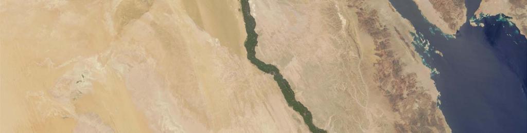
1 Weather and Wind Modeling in Egypt Meso-scale Meteorological (Weather Forecast) Modeling Presented By; Atef O. Sherif Aerospace Department Faculty of Engineering Cairo University
2 Collaborators Hamada Sultan BSc Aerospace Engineering, NARSS Mohamed Abd Elkader, Ahmed Abd Elmoaty MSc, Aerospace Engineering, NARSS Hamdi Kandil PhD, Mechanical Engineering, Alexandria University Basman El Hadidi PhD, Aerospace Engineering, Cairo University Atef Sherif PhD, Aerospace Engineering, Cairo University


3 Presentation layout


4 The unfortunate disaster by choice Economic stability Along Nile Branches a disaster What we discovered later!
5 General overview 1/3 Numerical meteorological models are used to asses air pollution o temperature inversion phenomenon o transport of pollutants/dust (sand storms) micro-climate change due to o natural causes formation of lakes, desertification, etc o man made causes: different land use categories Computational models are enhanced with remotely sensed observations for improvement of land surface modeling and accuracy
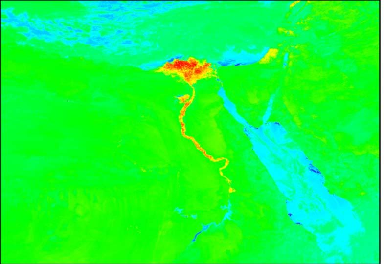
6 General overview 2/3 Climate trends in Eastern Mediterranean Recent numerical experiment suggests that severe deforestation around the Mediterranean in the last 2000 years was a major factor in current dry conditions Attributed to change in albedo, and increased evapo-transpiration Statistical trends from observations (over past 50 years) in the Eastern Mediterranean point to increased summer temperatures decreased winter temperatures reduced annual precipitation However, recent observations suggest that atmospheric sensitivity to land use change occurs locally Appreciable deviations in the semi-arid region of the Negev Desert and Gaza o Negev desert: intensive irrigation and changed albedo o Gaza: drastic population increase has led to a positive statistically significant minimum temperature increase all throughout the year
7 General overview 3/3 Different Flow Scales Meso-scale meteorology is the study of atmospheric phenomena with typical spatial scales between 10 and 1000 km Examples of meso-scale phenomena include thunderstorms, gap winds, down slope windstorms, land-sea breezes, etc Most weather phenomena that impacts human activity occur on the meso-scale Scale Length Area Locale Micro 1 m - 1 km 1 m² - 1 km² local Meso 1 km km 1 km² km² regional Macro (Synoptic) 100 km km 100 km² km² continental Mega > km > km² global
8 Long Term Objectives Aerodynamic model for airflow for Egypt Boundary layer corrections for urban cities and local land use Assimilation of remotely sensed satellite data to provide physically consistent estimates of the meteorological conditions. Meteorological assessment of air pollution Extreme air pollution events Atmospheric dispersion and transport of gases and particles Modeling long term local meteorological climate changes Due to aggressive land use/land cover change Due to formation of artificial water bodies Investigation of Wind Energy Potentials in Egypt Wind Farm Site operational Planning Statistical vs. Dynamic Forecast

9 Numerical Weather Models: MM5 & WRF The weather model for Egypt is based on the 5 th generation NCAR/Penn state meso-scale model (MM5) and The Weather Research and Forecast Model, WRF. Both are open source models, Continuously being improved by contributions from users worldwide The two models are designed to simulate and predict meso-scale and regional scale atmospheric circulations.


")


")
 Land use /")
10 Meteorological Modeling System Ground observations Assimilated in Model To improve the accuracy of the modeling results Gridded Data obtained from the global solvers to provide Initial and Boundary conditions with resolution up to 1 degree (111 km 2 ) Global Meteorological Data Terrestrial Data & Global Topology MM5 Model Updating The Model Post Processing Boundary Conditions High Resolution Data (One km or Less) Frequently updated (4-6 times daily) Land use / Land Cover Vegetation Fraction Terrain Elevation Soil Type
11 MODEL ENHANCEMENT AND VALIDATION

12 Satellite Data Assimilation of Surface Data NDVI Albedo LST/SST


13 Satellite Data Four Dimensional Data Assimilation ATOVS Temperature Retrieval ATOVS Water-Vapor Retrieval


14 Four Test Cases Four sets of simulations were performed; FDDA0: The reference case FDDA1: Grid FDDA from FNL. FDDA2: Grid FDDA from ATOVS FDDA3: Grid FDDA from FNL + ATOVS. Comparison of simulations results with surface observations at nine monitoring locations and soundings at five monitoring locations.

15 Results Vertical temperature profile for the different FDDA Techniques: at Helwan Station Percentage Change in X for FDDA i = 100 X ( FDDAi ) X ( FDDA0 ) X ( FDDA ) 0 FDDA1 is more efficient for research where FNL datasets are available FDDA2 can be used for dynamic analysis of operational predictions. FDDA3 has the maximum time cost and similar gains like FDDA1.
16 Results and Discussions

17 AIR POLLUTION ASSESSMENT
 Black cloud period (September, October and November) Khamasin Sand Storm WHO limits Black Cloud Monthly")
18 Air Pollution over Greater Cairo The PM10 exceeded the international limits over the year PM10 increases over Greater Cairo: Khamasin period (April, May) Black cloud period (September, October and November) Khamasin Sand Storm WHO limits Black Cloud Monthly average concentrations of PM 10 (data from 2000 to 2003), EEAA and Sivertsen, 2004
19 Air Pollution and Temperature Inversion The subsidence temperature inversion is defined as a temperature increase with height produced by the adiabatic warming of a layer of subsiding air. Layer just above subsidence inversions is usually relatively dry compared to the humid, stagnant and polluted layer below the inversion layer. Megacities in valleys in tropical zones are typical culprits High-pressure area north of Egypt, and low wind speed and high humidity are cause of this strong inversion
20 Parameters Affecting Temperature Inversion GTI (Your morning fog) STI Local topology and land use (affects surface heat fluxes) Surface heat fluxes and land surface type Regional must atmospheric be considered circulations for accurate High pressure system temperature inversion modeling by Water vapor content atmosphere Local topology and land use using a suitable land surface model Four norms to quantify temperature inversion Strength (average temperature gradient across inversion layer) Elevation (from bottom of inversion layer) Thickness Lifetime


21 Modeling of Temperature Inversion Inversion layer Latitude cross section at Cairo International Airport shows trapped water vapor under inversion layers Water vapor

22 Evaluation of Temperature Inversion During Air Pollution Episode over Cairo OOOOOOps Longitude Cross section Correlation Coefficient : 0.87 Latitude Cross section Inversion strength versus PM 10 at El Abbassya station EEAA & EIMP operated 42 air quality stations over Egypt to monitor NO 2, SO 2, O 3, CO, PM 10 and total suspended particulate. Inversion elevation versus PM 10 at El Abbassya station
23 Comparison Between GTI and PM10 over Greater Cairo
 particles suspended in")


24 Aerosol Optical Depth AOD is used to relative amount of aerosols (solid or liquid) particles suspended in the atmosphere. The MODIS aerosol optical depth product is a measure of how much light airborne particles prevent from passing through a column of atmosphere. AOD AOD Elevation Inversion strength 1 Inversion elevation
25 Evaluation of Subsidence Temperature Inversion using AOD 25
26 LOCAL CLIMATE CHANGES


27 Effects of Land Cover Changes on Egypt Weather Land cover changes modifies fluxes of momentum, heat, water, aerosols, and gases, as well as near surface radiation balances. Each flux modifications affect atmospheric circulation then cause variations in Temperature, Humidity, and Precipitation. Observations suggest that atmospheric sensitivity to land cover change also occurs locally. The Presence Urbanization of Lakes Sprawl in Toshka over Region Delta Northern Sinai After Reclamation

28 History of Toshka Lakes The Aswan High Dam constructed in Egypt in , created Lake Nasser, with a maximum water level of 183m above sea level. In 1978 Egypt began digging the draining Canal through Toshka valley to allow water levels higher than 178m to be drained off. In the late 1990s, water began flowing through Toshka Valley forming a group of lakes called Toshka lakes. Aswan High Dam Toshka Kalabsha Lakes Embayment Toshka Depression Toshka Valley Nasser Lake Satellite Image represent Showing for Aswan Toshka High Lakes Dam Valley MODIS IKONOS Satellite
29 Formation of Toshka Lakes


30 The Effective Distance of the Lakes 530 km 450 km Morning Noon Night

31 Percentage Change in Water Vapor Content after Adding the Lakes %

32 _ Relation between Water Vapor and precipitations mm Increases in water vapor at 2.5 km elevation induced by Toshka lakes The precipitations amount measured by the TRMM satellite March 2005

33 Urban Encroachment in Nile Delta Cairo 1965 Cairo 1998
34 Effect of Urban Sprawl on Vegetated Areas Urban sprawl creates "Urban Heat Islands" Elevated air temperatures over urban areas is retained by man-made materials such as asphalt which store much of the sun's energy Satellite observations indicate average temperature increase in cities from 2.7 to 5.6 o C than surrounding areas. source: U.S. Environmental Protection Agency (
35 Cross Sectional Temperature Changes after Taking the Urban Areas Effects Latitude cross section (B-B) Longitude cross section (A-A)


36 IMPACT OF THE NILE DELTA URBANIZATION ON THE TEMPERATURE INVERSION OOOOOOps The increase in heat capacity over urban areas and decrease in soil thermal conductivity and soil moisture, increased the total heat flux over urban areas. Land use


37 Land Reclamation in North of Sinai The trend in the eastern Mediterranean is, increased summer temperature, decreased winter temperature, and reduced annual precipitation. This trend however, exhibits appreciable deviations in semi-arid region of the Negev Desert, and the Gaza strip The NSADP plan to reclaim 400,000 acres
38 Changes in Temperature and Water Vapor after Adding the Vegetation Temperature differences Water vapor differences (%)
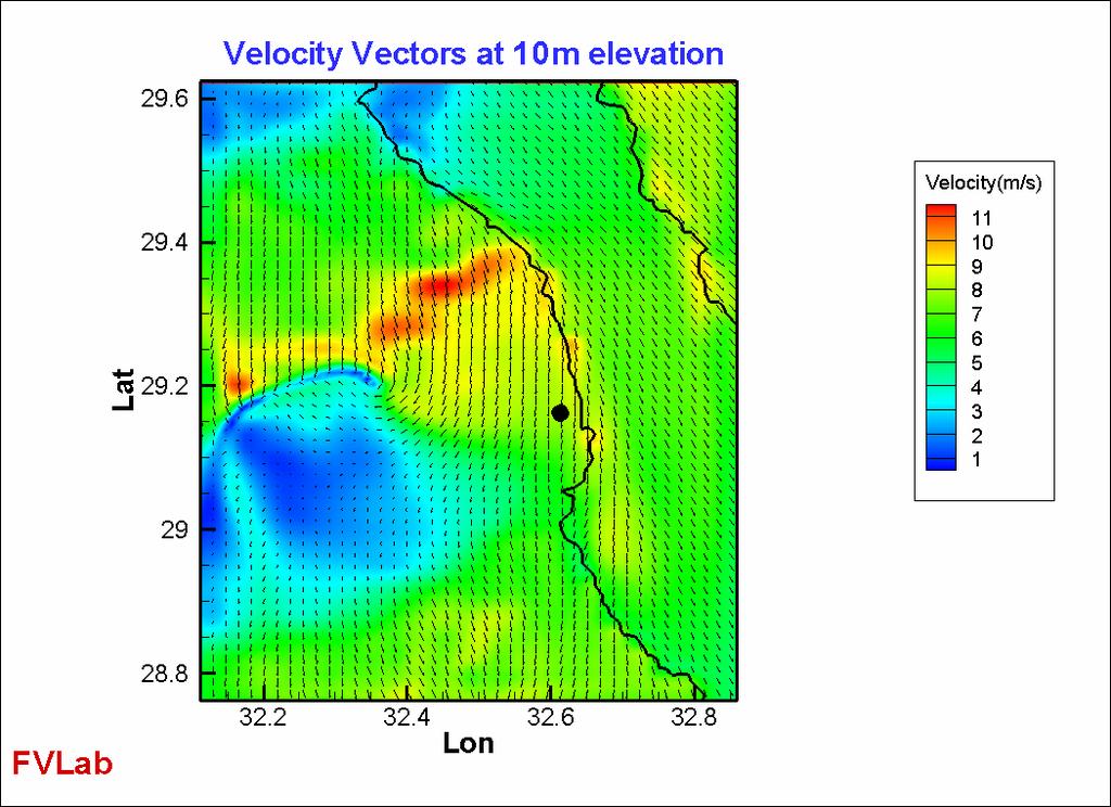
39 Changes in Velocity at 10m Elevation after adding The Vegetations


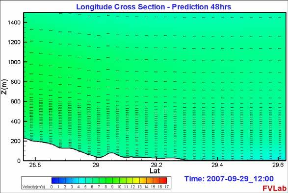
40 Regional Weather modeling: Africa Velocity Vectors


41 Regional Weather Modeling, MENA: Combined Velocity Vectors and Humidity Distribution

42 Regional Weather Modeling: Nile Basin Grid : 420x540x32 10Km Grid Pts : 8.6 M Cell Atef O. Sherif Nov.. 12, 2005

43 Velocity Vector At Elevation 2.7Km National Weather Modeling: Velocity Vectors

44 National Weather Modeling: Relative Humidity Atef O. Sherif Nov.. 12, 2005

45 Preliminary investigation at a Wind Farm Site 4- Levels model

46 Velocity and Power Density
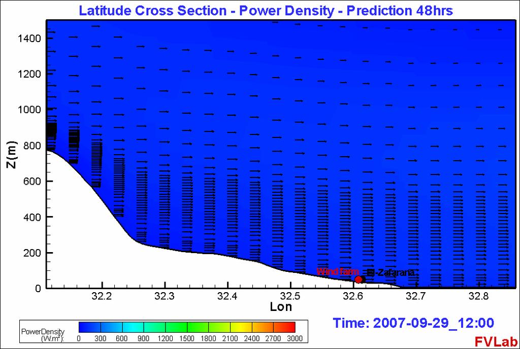
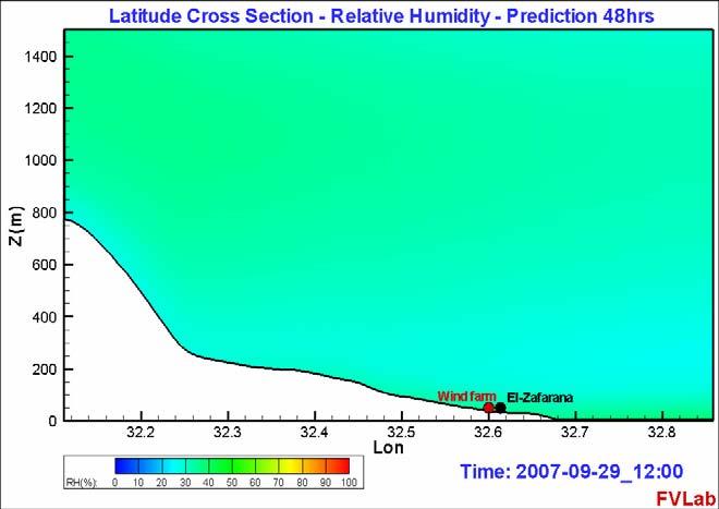
47 2-Days Simulation Latitude Cross Section

48 2-Days Simulation Longitudinal Cross Section
49 Wind Roses At a Wind Farm Site: A Demonstration of Possible Failure of the Statistical Planning Approach 3 days average Operations probable every day Day 1 Operation not an option Day 2 Operation probable Day 3 Operation probable
50 Conclusions Data assimilation in meteorological models improves accuracy of surface and aloft variables and are essential to predict thermal inversion Prediction of extreme pollution events has been validated Land cover change significantly impacts local meteorological conditions Along the lake shore, diurnal variations decreased by 2 o C with significant sea-breeze around the lake. Velocity is up to 5 m/s. Relative humidity increase by 90% along the lake shores. Urban encroachment in Delta increases average daily temperature by 0.28 degrees Intensive irrigation in North Sinai, results in significant temperature reduction in the cultivated areas Potential for Wind Energy Site Select, Operational Planning is Promising


51 Future Work
52 Thank You Thank you for Attention and Patience
Areas of the World with high Insolation
 Areas of the World with high Insolation 22 /43 Africa Annual Average Global Horizontal Solar Radiation Map 19 Jul 2006 A map depicting model estimates of monthly average daily total radiation using inputs
Dust storm variability over EGYPT By Fathy M ELashmawy Egyptian Meteorological Authority
 WMO WORKSHOP ON CLIMATE MONITORING INCLUDING THE IMPLEMENTATION OF CLIMATE WATCH SYSTEMS FOR ARAB COUNTRIES IN WEST ASIA, AMMAN, JORDAN, 27-29 MAY 2013 Dust storm variability over EGYPT By Fathy M ELashmawy
What is Climate? Understanding and predicting climatic changes are the basic goals of climatology.
 What is Climate? Understanding and predicting climatic changes are the basic goals of climatology. Climatology is the study of Earth s climate and the factors that affect past, present, and future climatic
Simulation of Air Quality Using RegCM Model
 Simulation of Air Quality Using RegCM Model The Regional Climate Model (RegCM) The Regional Climate Model (RegCM) is one of the RCMs that was originally developed at the National Center for Atmospheric
Making Rain on Arid Regions The GESHEM Rain System
 Making Rain on Arid Regions The GESHEM Rain System Pr. L.BRENIG. Physics Department Université Libre de Bruxelles (ULB) Brussels. Belgium. lbrenig@ulb.ac.be WEX-2007 Sevilla The project consists in using
LECTURE #14: Extreme Heat & Desertification
 GEOL 0820 Ramsey Natural Disasters Spring, 2018 LECTURE #14: Extreme Heat & Desertification Date: 27 February 2018 (lecturer: Dr. Shawn Wright) I. Start of Part 2 of the Course weather-related disasters
Energy Systems, Structures and Processes Essential Standard: Analyze patterns of global climate change over time Learning Objective: Differentiate
 Energy Systems, Structures and Processes Essential Standard: Analyze patterns of global climate change over time Learning Objective: Differentiate between weather and climate Global Climate Focus Question
WMO technical conference on climate services building on clips legacy
 WMO technical conference on climate services building on clips legacy conjunction with the Sixteenth Session of WMO Commission for Climatology (CCl-16) and the 35 th Meeting of the Joint Scientific Committee
SEASONAL AND DAILY TEMPERATURES
 1 2 3 4 5 6 7 8 9 10 11 12 SEASONAL AND DAILY TEMPERATURES Chapter 3 Earth revolves in elliptical path around sun every 365 days. Earth rotates counterclockwise or eastward every 24 hours. Earth closest
Chapter 3 Climate and the General Circulation
 Chapter 3 Climate and the General Circulation 1. Climate Defined 1.1. Weather and Climate When we talk about the weather, we are talking about the condition of the atmosphere at any particular time and
Name the surface winds that blow between 0 and 30. GEO 101, February 25, 2014 Monsoon Global circulation aloft El Niño Atmospheric water
 GEO 101, February 25, 2014 Monsoon Global circulation aloft El Niño Atmospheric water Name the surface winds that blow between 0 and 30 What is the atmospheric pressure at 0? What is the atmospheric pressure
ESCI 344 Tropical Meteorology Lesson 7 Temperature, Clouds, and Rain
 ESCI 344 Tropical Meteorology Lesson 7 Temperature, Clouds, and Rain References: Forecaster s Guide to Tropical Meteorology (updated), Ramage Tropical Climatology, McGregor and Nieuwolt Climate and Weather
JOURNAL OF INTERNATIONAL ACADEMIC RESEARCH FOR MULTIDISCIPLINARY Impact Factor 1.393, ISSN: , Volume 2, Issue 4, May 2014
 Impact Factor 1.393, ISSN: 3583, Volume, Issue 4, May 14 A STUDY OF INVERSIONS AND ISOTHERMALS OF AIR POLLUTION DISPERSION DR.V.LAKSHMANARAO DR. K. SAI LAKSHMI P. SATISH Assistant Professor(c), Dept. of
Graduate Courses Meteorology / Atmospheric Science UNC Charlotte
 Graduate Courses Meteorology / Atmospheric Science UNC Charlotte In order to inform prospective M.S. Earth Science students as to what graduate-level courses are offered across the broad disciplines of
Why the Earth has seasons. Why the Earth has seasons 1/20/11
 Chapter 3 Earth revolves in elliptical path around sun every 365 days. Earth rotates counterclockwise or eastward every 24 hours. Earth closest to Sun (147 million km) in January, farthest from Sun (152
DEPARTMENT OF EARTH & CLIMATE SCIENCES Name SAN FRANCISCO STATE UNIVERSITY Nov 29, ERTH 360 Test #2 200 pts
 DEPARTMENT OF EARTH & CLIMATE SCIENCES Name SAN FRANCISCO STATE UNIVERSITY Nov 29, 2018 ERTH 360 Test #2 200 pts Each question is worth 4 points. Indicate your BEST CHOICE for each question on the Scantron
UNIT 12: THE HYDROLOGIC CYCLE
 UNIT 12: THE HYDROLOGIC CYCLE After Unit 12 you should be able to: o Effectively use the charts Average Chemical Composition of Earth s Crust, Hydrosphere and Troposphere, Selected Properties of Earth
Analysis of meteorological measurements made over three rainy seasons in Sinazongwe District, Zambia.
 Analysis of meteorological measurements made over three rainy seasons in Sinazongwe District, Zambia. 1 Hiromitsu Kanno, 2 Hiroyuki Shimono, 3 Takeshi Sakurai, and 4 Taro Yamauchi 1 National Agricultural
CLIMATE. UNIT TWO March 2019
 CLIMATE UNIT TWO March 2019 OUTCOME 9.2.1Demonstrate an understanding of the basic features of Canada s landscape and climate. identify and locate major climatic regions of Canada explain the characteristics
DROUGHT ASSESSMENT USING SATELLITE DERIVED METEOROLOGICAL PARAMETERS AND NDVI IN POTOHAR REGION
 DROUGHT ASSESSMENT USING SATELLITE DERIVED METEOROLOGICAL PARAMETERS AND NDVI IN POTOHAR REGION Researcher: Saad-ul-Haque Supervisor: Dr. Badar Ghauri Department of RS & GISc Institute of Space Technology
Regional offline land surface simulations over eastern Canada using CLASS. Diana Verseghy Climate Research Division Environment Canada
 Regional offline land surface simulations over eastern Canada using CLASS Diana Verseghy Climate Research Division Environment Canada The Canadian Land Surface Scheme (CLASS) Originally developed for the
Tropical Climates Zone
 Tropical Climates Zone RAIN FOREST CENTRAL AFRICA, SOUTH AMERICA (AMAZON), CENTRAL AMERICA, S.E. ASIA HUMID/WARM ANNUAL RAINFALL 200 CM TYPE #1: TROPICAL DESERT N. AFRICA (SAHARA) & S.W. ASIA < 25 CM
L.O Students will learn about factors that influences the environment
 Name L.O Students will learn about factors that influences the environment Date 1. At the present time, glaciers occur mostly in areas of A) high latitude or high altitude B) low latitude or low altitude
Atmospheric Processes
 Atmospheric Processes Atmospheric prognostic variables Wind Temperature Humidity Cloud Water/Ice Atmospheric processes Mixing Radiation Condensation/ Evaporation Precipitation Surface exchanges Friction
Climates of NYS. Definitions. Climate Regions of NYS. Storm Tracks. Climate Controls 10/13/2011. Characteristics of NYS s Climates
 Definitions Climates of NYS Prof. Anthony Grande 2011 Weather and Climate Weather the state of the atmosphere at one point in time. The elements of weather are temperature, air pressure, wind and moisture.
8.1 Attachment 1: Ambient Weather Conditions at Jervoise Bay, Cockburn Sound
 8.1 Attachment 1: Ambient Weather Conditions at Jervoise Bay, Cockburn Sound Cockburn Sound is 20km south of the Perth-Fremantle area and has two features that are unique along Perth s metropolitan coast
Urban heat island in the metropolitan area of São Paulo and the influence of warm and dry air masses during summer
 Urban heat island in the metropolitan area of São Paulo and the influence of warm and dry air masses during summer Flavia N. D. Ribeiro1, Arissa S. umezaki1, Jhonathan F. T. de Souza1, Jacyra Soares2,
Atmospheric Composition and Structure
 Atmospheric Composition and Structure Weather and Climate What is weather? The state of the atmosphere at a specific time and place. Defined by: Humidity, temperature, wind speed, clouds, precipitation,
Logistics. Goof up P? R? Can you log in? Requests for: Teragrid yes? NCSA no? Anders Colberg Syrowski Curtis Rastogi Yang Chiu
 Logistics Goof up P? R? Can you log in? Teragrid yes? NCSA no? Requests for: Anders Colberg Syrowski Curtis Rastogi Yang Chiu Introduction to Numerical Weather Prediction Thanks: Tom Warner, NCAR A bit
Analysis on Climate Change of Guangzhou in Nearly 65 Years
 , pp.111-117 http://dx.doi.org/10.14257/astl.2016.138.24 Analysis on Climate Change of Guangzhou in Nearly 65 Years Wenzheng Yu, Haitao Liu, Chunyong Yin, Jin Wang College of Environmental Science and
Dust prediction models
 Dust prediction models Sara Basart 1 (sara.basart@bsc.es), E. Terradellas 2, E. Cuevas 3, O. Jorba 1, J.M. Baldasano 1 and F. Benincasa 1 1 Earth Sciences Department, BSC, Barcelona, Spain 2 AEMET, Barcelona,
The Contribution Of Fine Scale Atmospheric Numerical Models In Improving The Quality Of Hydraulic Modelling Outputs
 City University of New York (CUNY) CUNY Academic Works International Conference on Hydroinformatics 8-1-2014 The Contribution Of Fine Scale Atmospheric Numerical Models In Improving The Quality Of Hydraulic
GEOGRAPHY EYA NOTES. Weather. atmosphere. Weather and climate
 GEOGRAPHY EYA NOTES Weather and climate Weather The condition of the atmosphere at a specific place over a relatively short period of time Climate The atmospheric conditions of a specific place over a
Meteorology B Wright State Invite Team Name Team # Student Members: &
 1 Meteorology B Team Name Team # Student Members: & Raw Score: / 126 Rank: Part I. Multiple Choice. Answer the following questions by selecting the best answer. 2 points each. 1. All of the following are
Climate Change or Climate Variability?
 Climate Change or Climate Variability? Key Concepts: Greenhouse Gas Climate Climate change Climate variability Climate zones Precipitation Temperature Water cycle Weather WHAT YOU WILL LEARN 1. You will
ATMOSPHERIC CIRCULATION AND WIND
 ATMOSPHERIC CIRCULATION AND WIND The source of water for precipitation is the moisture laden air masses that circulate through the atmosphere. Atmospheric circulation is affected by the location on the
Prentice Hall EARTH SCIENCE
 Prentice Hall EARTH SCIENCE Tarbuck Lutgens Chapter 21 Climate 21.1 Factors That Affect Climate Factors That Affect Climate Latitude As latitude increases, the intensity of solar energy decreases. The
Seasonal & Diurnal Temp Variations. Earth-Sun Distance. Eccentricity 2/2/2010. ATS351 Lecture 3
 Seasonal & Diurnal Temp Variations ATS351 Lecture 3 Earth-Sun Distance Change in distance has only a minimal effect on seasonal temperature. Note that during the N. hemisphere winter, we are CLOSER to
Spatial Variability of Aerosol - Cloud Interactions over Indo - Gangetic Basin (IGB)
") Spatial Variability of Aerosol - Cloud Interactions over Indo - Gangetic Basin (IGB) Shani Tiwari Graduate School of Environmental Studies Nagoya University, Nagoya, Japan Email: pshanitiwari@gmail.com
Spatial Variability of Aerosol - Cloud Interactions over Indo - Gangetic Basin (IGB) Shani Tiwari Graduate School of Environmental Studies Nagoya University, Nagoya, Japan Email: pshanitiwari@gmail.com
Guided Notes: Atmosphere Layers of the Atmosphere
 Guided Notes: Atmosphere Layers of the Atmosphere Atmosphere: Absorbs solar radiation, Burns up meteors, transports and recycles water, and other chemicals, and moderates climate Main Components: o Meteorology
Impact of aerosol on air temperature in Baghdad
 Journal of Applied and Advanced Research 2017, 2(6): 317 323 http://dx.doi.org/10.21839/jaar.2017.v2i6.112 http://www.phoenixpub.org/journals/index.php/jaar ISSN 2519-9412 / 2017 Phoenix Research Publishers
Central Ohio Air Quality End of Season Report. 111 Liberty Street, Suite 100 Columbus, OH Mid-Ohio Regional Planning Commission
 217 218 Central Ohio Air Quality End of Season Report 111 Liberty Street, Suite 1 9189-2834 1 Highest AQI Days 122 Nov. 217 Oct. 218 July 13 Columbus- Maple Canyon Dr. 11 July 14 London 11 May 25 New Albany
5B.1 DEVELOPING A REFERENCE CROP EVAPOTRANSPIRATION CLIMATOLOGY FOR THE SOUTHEASTERN UNITED STATES USING THE FAO PENMAN-MONTEITH ESTIMATION TECHNIQUE
 DEVELOPING A REFERENCE CROP EVAPOTRANSPIRATION CLIMATOLOGY FOR THE SOUTHEASTERN UNITED STATES USING THE FAO PENMAN-MONTEITH ESTIMATION TECHNIQUE Heather A. Dinon*, Ryan P. Boyles, and Gail G. Wilkerson
Manfred A. Lange Energy, Environment and Water Research Center The Cyprus Institute. M. A. Lange 11/26/2008 1
 Manfred A. Lange Energy, Environment and Water Research Center The Cyprus Institute M. A. Lange 11/26/2008 1 Background and Introduction Mediterranean Climate Past and Current Conditions Tele-Connections
Climatic Classification of an Industrial Area of Eastern Mediterranean (Thriassio Plain: Greece)
") Climatic Classification of an Industrial Area of Eastern Mediterranean (Thriassio Plain: Greece) A. Mavrakis Abstract The purpose of this work is to investigate the possible differentiations of the climatic
Climatic Classification of an Industrial Area of Eastern Mediterranean (Thriassio Plain: Greece) A. Mavrakis Abstract The purpose of this work is to investigate the possible differentiations of the climatic
Creating Meteorology for CMAQ
 Creating Meteorology for CMAQ Tanya L. Otte* Atmospheric Sciences Modeling Division NOAA Air Resources Laboratory Research Triangle Park, NC * On assignment to the National Exposure Research Laboratory,
b) occurs before the anvil shape at the top of the cloud has formed. c) is marked by an absence of significant downdrafts.
 occurs before the anvil shape at the top of the cloud has formed. c) is marked by an absence of significant downdrafts.") Thunderstorms Question 1 The only requirement for a thunderstorm is: a) sinking air. b) upper level convergence. c) still air. d) rising air. Question 2 The mature stage of air-mass thunderstorms: a) is
Thunderstorms Question 1 The only requirement for a thunderstorm is: a) sinking air. b) upper level convergence. c) still air. d) rising air. Question 2 The mature stage of air-mass thunderstorms: a) is
Chapter outline. Reference 12/13/2016
 Chapter 2. observation CC EST 5103 Climate Change Science Rezaul Karim Environmental Science & Technology Jessore University of science & Technology Chapter outline Temperature in the instrumental record
Definitions Weather and Climate Climates of NYS Weather Climate 2012 Characteristics of Climate Regions of NYS NYS s Climates 1.
 Definitions Climates of NYS Prof. Anthony Grande 2012 Weather and Climate Weather the state of the atmosphere at one point in time. The elements of weather are temperature, t air pressure, wind and moisture.
A severe dust event over the Mongolian Gobi in 3-5 March, 2016
 A severe dust event over the Mongolian Gobi in 3-5 March, 2016 Dr.D.Jugder and E.Munkhjargal Information and Research Institute of Meteorology, Hydrology and Environment The 4 th Session of East Asia winter
Egyptian Meteorological Authority Cairo Numerical Weather prediction centre
 JOINT WMO TECHNICAL PROGRESS REPORT ON THE GLOBAL DATA PROCESSING AND FORECASTING SYSTEM AND NUMERICAL WEATHER PREDICTION RESEARCH ACTIVITIES FOR 2016 Egyptian Meteorological Authority Cairo Numerical
Numerical simulation of relationship between climatic factors and ground ozone concentration over Kanto area using the MM5/CMAQ Model
 251 Numerical simulation of relationship between climatic factors and ground ozone concentration over Kanto area using the MM5/CMAQ Model Mai Van KHIEM, Ryozo OOKA, Hong HUANG and Hiroshi HAYAMI In recent
MPCA Forecasting Summary 2010
 MPCA Forecasting Summary 2010 Jessica Johnson, Patrick Zahn, Natalie Shell Sonoma Technology, Inc. Petaluma, CA Presented to Minnesota Pollution Control Agency St. Paul, MN June 3, 2010 aq-ppt2-01 907021-3880
p = ρrt p = ρr d = T( q v ) dp dz = ρg
 dp dz = ρg") Chapter 1: Properties of the Atmosphere What are the major chemical components of the atmosphere? Atmospheric Layers and their major characteristics: Troposphere, Stratosphere Mesosphere, Thermosphere
Chapter 1: Properties of the Atmosphere What are the major chemical components of the atmosphere? Atmospheric Layers and their major characteristics: Troposphere, Stratosphere Mesosphere, Thermosphere
NIDIS Intermountain West Drought Early Warning System November 21, 2017
 NIDIS Drought and Water Assessment NIDIS Intermountain West Drought Early Warning System November 21, 2017 Precipitation The images above use daily precipitation statistics from NWS COOP, CoCoRaHS, and
GEO1010 tirsdag
 GEO1010 tirsdag 31.08.2010 Jørn Kristiansen; jornk@met.no I dag: Først litt repetisjon Stråling (kap. 4) Atmosfærens sirkulasjon (kap. 6) Latitudinal Geographic Zones Figure 1.12 jkl TØRR ATMOSFÆRE Temperature
Ch. 3: Weather Patterns
 Ch. 3: Weather Patterns Sect. 1: Air Mass & Fronts Sect. 2: Storms Sect. 3: Predicting the Weather Sect. 4: Weather forecasters use advanced technologies Ch. 3 Weather Fronts and Storms Objective(s) 7.E.1.3
Lab Activity: Climate Variables
 Name: Date: Period: Water and Climate The Physical Setting: Earth Science Lab Activity: Climate Variables INTRODUCTION:! The state of the atmosphere continually changes over time in response to the uneven
Weather and Climate. Weather the condition of the Earth s atmosphere at a particular time and place
 Weather and Climate Weather the condition of the Earth s atmosphere at a particular time and place Climate the average year-after-year conditions of temperature, precipitation, winds and clouds in an area
1 What Is Climate? TAKE A LOOK 2. Explain Why do areas near the equator tend to have high temperatures?
 CHAPTER 17 1 What Is Climate? SECTION Climate BEFORE YOU READ After you read this section, you should be able to answer these questions: What is climate? What factors affect climate? How do climates differ
D15: Simulation of a Dust Event over Cyprus
 D15: Simulation of a Dust Event over Cyprus An episode of low visibility was observed over Cyprus in late September 2011. It appears that it was caused by an increase in the atmospheric dust concentration
Climate and the Atmosphere
 Climate and Biomes Climate Objectives: Understand how weather is affected by: 1. Variations in the amount of incoming solar radiation 2. The earth s annual path around the sun 3. The earth s daily rotation
Page 1. Name:
 Name: 1) As the difference between the dewpoint temperature and the air temperature decreases, the probability of precipitation increases remains the same decreases 2) Which statement best explains why
Investigating the urban climate characteristics of two Hungarian cities with SURFEX/TEB land surface model
 Investigating the urban climate characteristics of two Hungarian cities with SURFEX/TEB land surface model Gabriella Zsebeházi Gabriella Zsebeházi and Gabriella Szépszó Hungarian Meteorological Service,
Prentice Hall EARTH SCIENCE
 Prentice Hall EARTH SCIENCE Tarbuck Lutgens Chapter 21 Climate 21.1 Factors That Affect Climate Factors That Affect Climate Latitude As latitude increases, the intensity of solar energy decreases. The
Weather and the Atmosphere. RAP Short Course
 Weather and the Atmosphere RAP Short Course Syllabus 1) Vertical structure and composition of the atmosphere, basic weather variables 2) Warming Earth and its atmosphere the diurnal and seasonal cycles
«Action Thématique Incitative sur Programme» CNRS/INSU
 Development and validation of a regional model of desert dust for the study of seasonal and interannual variations over Sahara and Sahel coupling with satellite observations «Action Thématique Incitative
Near-surface weather prediction and surface data assimilation: challenges, development, and potential data needs
 Near-surface weather prediction and surface data assimilation: challenges, development, and potential data needs Zhaoxia Pu Department of Atmospheric Sciences University of Utah, Salt Lake City, Utah,
NIDIS Intermountain West Drought Early Warning System September 4, 2018
 NIDIS Drought and Water Assessment NIDIS Intermountain West Drought Early Warning System September 4, 2018 Precipitation The images above use daily precipitation statistics from NWS COOP, CoCoRaHS, and
Week: Dates: 3/2 3/20 Unit: Climate
 clementaged.weebly.com Name: EVEN Period: Week: 28 30 Dates: 3/2 3/20 Unit: Climate Monday Tuesday Wednesday Thursday Friday 2 O 3 E *Vocabulary *Water in the Atmosphere and Clouds Notes *Cloud Drawings
Final Exam: Monday March 17 3:00-6:00 pm (here in Center 113) Slides from Review Sessions are posted on course website:
 Slides from Review Sessions are posted on course website:") Final Exam: Monday March 17 3:00-6:00 pm (here in Center 113) 35% of total grade Format will be all multiple choice (~70 questions) Final exam will cover entire course - material since 2 nd midterm weighted
Final Exam: Monday March 17 3:00-6:00 pm (here in Center 113) 35% of total grade Format will be all multiple choice (~70 questions) Final exam will cover entire course - material since 2 nd midterm weighted
Final Weather Unit Study Guide
 Name: Atmospheric Composition and Layers Altitude Atmosphere Composition Troposphere Air Pressure Stratosphere Mesosphere Thermosphere Exosphere Ionosphere Sample Questions: Final Weather Unit Study Guide
Name: Regents Earth Science. Weather and Climate - Review Questions
 Name: Regents Earth Science Weather and Climate - Review Questions Date: Thayer - 279 1. People sometimes release substances into the atmosphere to increase the probability of rain by A) raising the air
25.1 Air Masses. Section 25.1 Objectives
 Section 25.1 Objectives Explain how an air mass forms. List the four main types of air masses. Describe how air masses affect the weather of North America. Air Masses 25.1 Air Masses Differences in air
Page 1. Name: 4) State the actual air pressure, in millibars, shown at Miami, Florida on the given weather map.
 State the actual air pressure, in millibars, shown at Miami, Florida on the given weather map.") Name: Questions 1 and 2 refer to the following: A partial station model and meteorological conditions table, as reported by the weather bureau in the city of Oswego, New York, are shown below. 1) Using
Name: Questions 1 and 2 refer to the following: A partial station model and meteorological conditions table, as reported by the weather bureau in the city of Oswego, New York, are shown below. 1) Using
Unit 9: Climate & Meteorology. Vocabulary
 Unit 9: Climate & Meteorology Vocabulary Weather Temperature Dew Point Relative Humidity Psychrometer Air Pressure Barometer Isobars Wind Anemometer condensation Sea Breeze Land Breeze Coriolis Effect
PERFORMANCE OF THE WRF-ARW IN THE COMPLEX TERRAIN OF SALT LAKE CITY
 P2.17 PERFORMANCE OF THE WRF-ARW IN THE COMPLEX TERRAIN OF SALT LAKE CITY Jeffrey E. Passner U.S. Army Research Laboratory White Sands Missile Range, New Mexico 1. INTRODUCTION The Army Research Laboratory
Chapter 2: Physical Geography
 Chapter 2: Physical Geography Pg. 39-68 Learning Goals for Chp2: q q q q q Explain how the Earth moves in space and why seasons change. Outline the factors that influence climate and recognize different
Plan for operational nowcasting system implementation in Pulkovo airport (St. Petersburg, Russia)
") Plan for operational nowcasting system implementation in Pulkovo airport (St. Petersburg, Russia) Pulkovo airport (St. Petersburg, Russia) is one of the biggest airports in the Russian Federation (150
Plan for operational nowcasting system implementation in Pulkovo airport (St. Petersburg, Russia) Pulkovo airport (St. Petersburg, Russia) is one of the biggest airports in the Russian Federation (150
La circulation atmosphérique dans le sud du Portugal et l'effet du réservoir d'alqueva. Cas d étude ALEX 2014
 8th Meso-NH user's meeting La circulation atmosphérique dans le sud du Portugal et l'effet du réservoir d'alqueva. Cas d étude ALEX 2014, Carlos Policarpo et Miguel Potes Instituto de Ciências da Terra
Observed Climate Variability and Change: Evidence and Issues Related to Uncertainty
 Observed Climate Variability and Change: Evidence and Issues Related to Uncertainty David R. Easterling National Climatic Data Center Asheville, North Carolina Overview Some examples of observed climate
Simulation studies for Lake Taihu effect on local meteorological environment. Ren Xia
 Simulation studies for Lake Taihu effect on local meteorological environment Ren Xia 2017.05.12 1 Outline Background Experimental design Result and discussion Next work Background Taihu Lake is the largest
SIO15 Midterm 2, Friday Dec. 1, 2017 TEST VARIATION: 2
 SIO15 Midterm 2, Friday Dec. 1, 2017 TEST VARIATION: 2 1) Why does San Diego have flood control channels? a) many hurricanes make landfall and bring devastating floods b) strong winter storms can bring
INVESTIGATION OF SAHARAN DUST TRANSPORT ON THE BASIS OF AEROLOGICAL MEASUREMENTS
 INVESTIGATION OF SAHARAN DUST TRANSPORT ON THE BASIS OF AEROLOGICAL MEASUREMENTS R. TÓTH 1, L. NYITRAI 1 ABSTRACT. Investigation of Saharan dust transport on the basis of aerological measurements. The
Mesoscale meteorological models. Claire L. Vincent, Caroline Draxl and Joakim R. Nielsen
 Mesoscale meteorological models Claire L. Vincent, Caroline Draxl and Joakim R. Nielsen Outline Mesoscale and synoptic scale meteorology Meteorological models Dynamics Parametrizations and interactions
Fog Hazards in Punjab
 Pakistan Journal of Meteorology Vol. 8, Issue 16: Jan, 2012 Fog Hazards in Punjab Aslam, M. 1 Abstract Using 30-year (1976-2005) real meteorological data of 10-weather stations, four dense fog years (1998-1999,
Lecture #14 March 29, 2010, Monday. Air Masses & Fronts
 Lecture #14 March 29, 2010, Monday Air Masses & Fronts General definitions air masses source regions fronts Air masses formation types Fronts formation types Air Masses General Definitions a large body
El Niño / Southern Oscillation
 El Niño / Southern Oscillation Student Packet 2 Use contents of this packet as you feel appropriate. You are free to copy and use any of the material in this lesson plan. Packet Contents Introduction on
ROLE OF CLOUD RADIATION INTERACTION IN THE DIURNAL VARIATION OF PRECIPITATION
 ROLE OF CLOUD RADIATION INTERACTION IN THE DIURNAL VARIATION OF PRECIPITATION SETHU RAMAN AND ADRIENNE WOOTTEN DEPARTMENT OF MARINE, EARTH AND ATMOSPHERIC SCIENCES NORTH CAROLINA STATE UNIVERSITY, RALEIGH,
Quiz 2 Review Questions
 Quiz 2 Review Questions Chapter 7 Lectures: Winds and Global Winds and Global Winds cont 1) What is the thermal circulation (thermal wind) and how does it form? When we have this type of circulation, how
ATMOSPHERIC ENERGY and GLOBAL TEMPERATURES. Physical Geography (Geog. 300) Prof. Hugh Howard American River College
 Prof. Hugh Howard American River College") ATMOSPHERIC ENERGY and GLOBAL TEMPERATURES Physical Geography (Geog. 300) Prof. Hugh Howard American River College RADIATION FROM the SUN SOLAR RADIATION Primarily shortwave (UV-SIR) Insolation Incoming
ATMOSPHERIC ENERGY and GLOBAL TEMPERATURES Physical Geography (Geog. 300) Prof. Hugh Howard American River College RADIATION FROM the SUN SOLAR RADIATION Primarily shortwave (UV-SIR) Insolation Incoming
May 3, :41 AOGS - AS 9in x 6in b951-v16-ch13 LAND SURFACE ENERGY BUDGET OVER THE TIBETAN PLATEAU BASED ON SATELLITE REMOTE SENSING DATA
 Advances in Geosciences Vol. 16: Atmospheric Science (2008) Eds. Jai Ho Oh et al. c World Scientific Publishing Company LAND SURFACE ENERGY BUDGET OVER THE TIBETAN PLATEAU BASED ON SATELLITE REMOTE SENSING
Earth is tilted (oblique) on its Axis!
 on its Axis!") MONDAY AM Radiation, Atmospheric Greenhouse Effect Earth's orbit around the Sun is slightly elliptical (not circular) Seasons & Days Why do we have seasons? Why aren't seasonal temperatures highest at
MONDAY AM Radiation, Atmospheric Greenhouse Effect Earth's orbit around the Sun is slightly elliptical (not circular) Seasons & Days Why do we have seasons? Why aren't seasonal temperatures highest at
Treatment of Land-Use and Urbanization
 Treatment of Land-Use and Urbanization LECTURE 9 Alexander Mahura Danish Meteorological Institute, DMI, Copenhagen, Denmark NetFAM Summer School on Integrated Modelling 7-12 July 2008, Zelenogorsk, Russia
Topic 1 The Atmosphere and Atmospheric Variables
 Name Notes: Topic 1 The Atmosphere Regents Earth Science Topic 1 The Atmosphere and Atmospheric Variables What is the atmosphere? Meteorology is the study of A. Structure of the Atmosphere: What two gases
NIDIS Intermountain West Drought Early Warning System April 18, 2017
 1 of 11 4/18/2017 3:42 PM Precipitation NIDIS Intermountain West Drought Early Warning System April 18, 2017 The images above use daily precipitation statistics from NWS COOP, CoCoRaHS, and CoAgMet stations.
Meteorology. Circle the letter that corresponds to the correct answer
 Chapter 3 Worksheet 1 Meteorology Name: Circle the letter that corresponds to the correct answer 1) If the maximum temperature for a particular day is 26 C and the minimum temperature is 14 C, the daily
Analysis of TRMM Precipitation Radar Measurements over Iraq
 International Journal of Scientific and Research Publications, Volume 6, Issue 12, December 2016 1 Analysis of TRMM Precipitation Radar Measurements over Iraq Munya F. Al-Zuhairi, Kais J. AL-Jumaily, Ali
3) What is the difference between latitude and longitude and what is their affect on local and world weather and climate?
 What is the difference between latitude and longitude and what is their affect on local and world weather and climate?") www.discoveryeducation.com 1) Describe the difference between climate and weather citing an example of each. Describe how water (ocean, lake, river) has a local effect on weather and climate and provide
www.discoveryeducation.com 1) Describe the difference between climate and weather citing an example of each. Describe how water (ocean, lake, river) has a local effect on weather and climate and provide
Use of Nowcasting tools, developed in SAF for the diagnosis of fogs in the South Plateau of the Iberian Peninsula.
 Use of Nowcasting tools, developed in SAF for the diagnosis of fogs in the Darío Cano and Ignacio Palacios Meteorological Regional Centre in Madrid and Castilla-La Mancha Objective: To obtain a vision