Town Hall Meeting on Individual and Family Disaster Preparedness
|
|
|
- Noah Charles
- 5 years ago
- Views:
Transcription


1 Town Hall Meeting on Individual and Family Disaster Preparedness Tuesday, 28 May 2013, Auditorium Zones B & C, Asian Development Bank, Mandaluyong City Susan R. Espinueva, Ph. D. Chief, Hydrometeorology Division, PAGASA-DOST


2 OUTLINE OF PRESENTATION Introduction: Understanding the hazards Impacts of tropical cyclones & flooding Preparedness measures


3 Introduction El Niño La Niña Semi-permanent cyclones & anti-cyclones Air streams SW & NE monsoon Ocean currents Linear systems ITCZ, cold front, easterly wave Tropical cyclones ENSO phenomena (El Niño & La Niña) Climatic controls that influence Philippine climate. Geography & topography
 Land area: 300,000 sq. km.")
4 Introduction Topographic map Major river basins Average annual rainfall: - 2,400 mm (50% comes from Tropical Cyclones) Land area: 300,000 sq. km. The Philippines has principal river basins - 18 are major river basins
5 1. Understanding the hazards
 - 45 to 63 KPH Tropical Storm (TS) - 64 to 118 KPH Typhoon (TY)")
.")
6 What is a tropical cyclone? A tropical cyclone is classified based on its wind strength: Tropical Depression (TD) - 45 to 63 KPH Tropical Storm (TS) - 64 to 118 KPH Typhoon (TY) - greater than 118 KPH 25,120 21,120 15,115 5,115 25,135 5,135 Visited by an average 19 to 20 Tropical cyclones EVERY YEAR Cinco, et al, 2010 For Manila, we experience 1 TC every year. From 1948 to 2010: 1228 tropical cyclones have crossed the Philippine Area of Responsibility (PAR). Wind speed ranges from 40 KPH to about 300 KPH. Diameter ranges from 300 to 1,000 kms. Tropical Cyclone Frequency using 1 x1 ( )


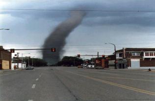


7 Hazards associated with tropical cyclones Strong Winds Tornadoes Storm Surges Flashfloods/Floods Landslides/Mudflows
8 2. Impacts of tropical cyclones & flooding


")

9 IMPACTS of Weather Phenomena in the PH : Ty Feria Jul 2001 TS Ondoy 26 Sep 2009 Landslide : Ginsaugon, Feb 2006 Affected families 26,978,106 Affected persons 136,543,259 Casualties 23,892 Cost of Damages: Agriculture: PhP billion Infrastructure: PhP billion Private properties: PhP billion Total cost of damages: PhP265.5 billion Source: Office of Civil Defense Ty Frank June 21, (MV Princess of the Stars) Ty Milenyo Sep 25-29, 2006 Ty Reming Nov Dingalan, Aurora, Dec Dec. 2003, Brgy. Pinutan, San Ricardo, Panaon Island, Southern Leyte.
10 2. Impacts of tropical cyclones & flooding


11 Map of Greater Metro Manila Administration Areas in GMMA River Basins, Lake Basin, and Drainage Basins in GMMA
 of the")


12 Effective Flood Control Operation System (EFCOS) of the Pasig-Marikina- Laguna Lake Complex Psig-Marikina Laguna Lake River Basin Main river: Marikina & Pasig Tributaries: Political subdivisions Nangka river in San Mateo, San Juan river Napindan river

13 Effective Flood Control Operation System (EFCOS) of the Pasig-Marikina- Laguna Lake Complex Originally, EFCOS was under DPWH but in 2003, after its expansion by JICA, it was turned over to MMDA. Operation of EFCOS The forecast flood in the Upper Marikina river will be the basis to operate the Rosario weir & divert flow to Laguna Lake thru the Manggahan Floodway. PAGASA & DPWH act as monitoring agencies. When flood in Pasig river subsides, temporary detained water from Laguna Lake will be discharged to Manila Bay thru the Napindan Channel.
 in Greater Metro")
14 Impacts of flooding due to passage of TS Ondoy (Sep 26, 2009) in Greater Metro Manila


15 Signatures of a Flood Disaster Flash Flood in Metro Manila due to TS Ondoy In 2003, Bankoff described in depth that Metro Manila s vulnerability to flooding has evolved as a result of the degree of interplay between climate, topography, resource use, and culture over time. The flood due to TS Ondoy in Sep 2009 proved it. Intense rainfall Insufficient carrying capacities High/dense population High urbanization level Unabated/rampant development Deforestation Insufficient warnings Informal settlers


16 Flood depth and duration maps of GMMA due to passage of TS Ondoy in 2009 Flood Depth Map of Ondoy Flood in 2009 Flood Duration Map of Ondoy Flood in 2009


17 Landslide & Flood hazard Map of Metro Manila after Ondoy All Rights Reserved (July 2000, modified September 2009) Flood Prone Areas for 2- to 10-year flood cycle Miranda, 1994: DENR- EMB/CDPWH Flood Prone Areas for year flood cycle Punongbayan, 1987 & Balce, et al., 1994 Flood Prone Areas adjacent to creeks Metro manila Boundary Landslide and Flood Susceptibility Map of Metro Manila


18 Impacts of Habagat Casualties: 51, injured: 35; & missing: 6 Damages: P406.2 million Duration of continuous rainfall: July 16 Aug 8 = 24 days Date Rainfall % Monthly TC in PAR Remarks (mm) Normal Rainfall 26 Sep % TS Ondoy TS crossed C. Luzon 2009 (Sep 24-27) 7 Aug % No TC TS Haikui far N near China 7 Jun % No TC TY S of Japan 6 Aug % No TC TS Haikui far N near China 8 Aug % No TC TS Haikui over China 2 Sep % TS Norming (Sep 2-8) 4 Sep % TS Maring (Sep 2-8) NE of Luzon to Taiwan E-NE-W of Luzon NLEX E. Rodriguez NLEX


 Non-TC events: 52 (48.")


19 Rainfall & Thunderstorm Warning System for Metro Manila Max 1-hr for TC events: 75.1 mm Max 1-hr for Non-TC events: 97 mm TC events: 55 (51.4%) Non-TC events: 52 (48.6%) Rainfall Warning System Source: HMD, PAGASA Subic Thunderstorm Warning System Tagaytay be website Innovations in PAGASA s Warning Services 1. Rainfall Warning System launched: on 10 Jun Thunderstorm Warning System
 - MMDA KOICA - PAGASA")
 Water level stations (10 KOICA; 1 CIDA; --")


20 Integrated Flood Warning System for Metro Manila Integrated Network & Warning System EFCOS (JICA) - MMDA KOICA - PAGASA CIDA - PAGASA Facilities: Rainfall stations (10 KOICA; 6 EFCOS; 22 CIDA) Water level stations (10 KOICA; 1 CIDA; -- EFCOS) Automatic Weather Station (AWS): 4 KOICA Warning Stations (20 along Pasig-Marikina KOICA; 4 along Manggahan Floodway EFCOS) Launched: 06 Jul 2012 in Marikina City Real-time access of Radar data, AWS, Rainfall & Water Level Data & Rainfall Forecasts
21 EWS for flood carried out on a river basin approach. Threshold for Flood Warnings: 1. Rainfall intensities Rainfall Values Meaning Flood Warning Rainfall observation of 5 to 9 mm per hour Rainfall observation 10 to 19 mm/hour Rainfall observation of 20 mm/hour or more Awareness Preparedness Response READY GET SET GO Station Name Gauge Datum Assessment Levels Alert Alarm Critical 1. Burgos San Mateo Mindanao Tumana Sto. Niño Marcos Highway Rosario L.S Rosario J.S Napindan I Napindan II Threshold for Flood Warnings: 2. Assessment Water Levels Actual Water Level (m) Meaning Flood Warning Alert m Awareness READY Alarm m Preparedness GET SET Critical m Response GO Note: Values are arbitrary and will be modified when sufficient data becomes available.
22 3. Preparedness measures


23 Typical tropical cyclone damage 4 Widespread damage to infrastructure and agriculture. 3 2 Heavy damage to agriculture; Some large tress uprooted; Majority of nipa and cogon houses unroofed or destroyed, considerable damage to structures of light to medium construction; Moderate to heavy disruption of electrical power and communication services; Travel by land, sea and air is dangerous. Moderate damage to agriculture; Rice and corn adversely affected; Few large tress uprooted; Large number of nipa and cogon house partially or totally unroofed; Travel by land, sea and air is dangerous. PSWS 1 Rice in flowering stage may suffer significant damage. Some nipa and cogon houses may be partially unroofed. Sea travel of small sea crafts and fishing boats is risky.

 houses may be partially unroofed. Very light or no damage at all may be sustained by exposed communities. What to do?")

24 3. Preparedness measures Public Storm Warning Signal Number 1 A tropical cyclone may threaten or affect the locality. Winds of not more than 60 KPH may be expected in at least 36 hours. Potential Impacts Twigs and branches of small trees may be broken. Some banana plants may tilt or land flat on the ground. Rice in flowering stage may suffer significant damage. Some houses of very light materials (nipa and cogon) houses may be partially unroofed. Very light or no damage at all may be sustained by exposed communities. What to do? Listen to your radio for more information about the weather disturbance. Check the capacity of the house to withstand strong winds and strengthen the house if necessary. Prepare flashlights, batteries, matches, kerosene lamps or candles and charcoal in anticipation of power failure. Listen to the latest PAGASA s Severe Weather Bulletin issued by every 6 hours. In the meantime, business may be carried out as. usual except when flood occurs Disaster preparedness plan is activated to alert status.


25 3. Preparedness measures Public Storm Warning Signal Number 2 A moderate tropical cyclone may affect the locality. Winds of not more than 61 to 100 KPH may be expected in at least 24 hours. Potential Impacts Some coconut trees maybe tilted with few others broken. Few big trees maybe uprooted. Many banana plants maybe downed. Rice and corn maybe adversely affected. Large number of nipa and cogon houses maybe partially or totally unroofed. Some old galvanized iron roofing maybe peeled off. Light to moderate damage to the exposed communities. What to do? Special attention should be given to the latest position, the direction and speed of movement as it may intensify and move towards the locality. The general public, especially people traveling by sea and air are cautioned to avoid unnecessary risks. Secure properties before the signal are upgraded. Board up windows or put storm shutters in place and securely fastened. Stay at home. Disaster preparedness agencies must alert their communities.


26 3. Preparedness measures Public Storm Warning Signal Number 3 A strong tropical will affect the locality. Winds of 101 to 180 KPH may be expected in at least 18 hours. Potential Impacts Many coconut trees may be broken or destroyed. Almost all banana plants may be downed and a large number of trees may be uprooted. Majority of nipa and cogon houses maybe unroofed or destroyed and considerable damage to structures of light to medium construction. Widespread disruption of electrical power and communication services. Moderate to heavy damage maybe experienced in the industrial sectors. What to do? Keep your radio on and listen to the latest news about typhoon. Everybody is advised to stay indoors. People are advised to stay in strong buildings. Evacuate from low-lying areas. Stay away from coastal areas and riverbanks. Watch out for the passage of the Eye Wall and the Eye of the typhoon. Disaster preparedness and response agencies are in action with appropriate response to actual emergency.


27 3. Preparedness measures Public Storm Warning Signal Number 4 A very strong tropical cyclone will affect the locality. Very strong winds of more than 180 KPH may be expected in at least 12 hours. Potential Impacts Coconut plantations may suffer extensive damage. Many large trees may be uprooted. Most residential and institutional buildings of mixed construction material may be severely damaged. Electrical power distribution and communication services may be severely disrupted. Damage to affected communities can be very heavy. What to do? The situation is potentially very destructive to the community. Stay in safe houses or evacuation centers!!! All travels and outdoor activities should be cancelled. Generally, damage to affected communities can be very heavy. The National Disaster Risk Reduction Office and other disaster response organizations are now fully responding to emergencies and in full readiness to immediately respond to possible calamity.
28 FLOOD SAFETY RULES BEFORE THE FLOOD: Find out how often your location is likely to be flooded. Know the flood warning system in your community and be sure your family knows it. Keep informed of daily weather condition. Designate an evacuation area for the family and livestock. Assign family members instructions and responsibilities according to an evacuation plan. Keep a stock of food which requires little cooking and refrigeration; electric power may be interrupted. Keep a transistorized radio and flashlight with spare batteries, emergency cooking equipment, candies, matches and first aid kit handy in case of emergency. Store supplies and other household effects above expected flood water level. Securely anchor weak dwellings and items
29 FLOOD SAFETY RULES WHEN WARNED OF FLOOD: Watch for rapidly rising flood waters. Listen to your radio for emergency instructions. If you find it necessary to evacuate, move to a safe area before access is cut off by flood waters. Store drinking water in containers, water service may be interrupted. Move household belongings to upper levels. Get livestock to higher grounds. Turn off electricity at the main switch in the building before evacuating and also lock your house.
30 FLOOD SAFETY RULES DURING THE FLOOD: Avoid areas subject to sudden flooding. Do not attempt to cross rivers of flowing streams where water is above the knee. Beware of water-covered roads and bridges. Avoid unnecessary exposure to the elements. Do not go swimming or boating in swollen rivers. Eat only well-cooked food. Protect leftovers against contamination. Drink clean or preferably boiled water ONLY.
31 FLOOD SAFETY RULES AFTER THE FLOOD: Re-enter the dwellings with caution using flashlights, not lanterns or torches. Flammables may be inside. Be alert for fire hazards like broken wires. Do not eat food and drink water until they have been checked for flood water contamination. Report broken utility lines (electricity, water, gas and telephone) to appropriate agencies authorities. Do not turn on the main switch or use appliances and other equipment until they have been checked by a competent electrician. Consult health authorities for immunization requirements. Do not go in disaster areas. Your presence might hamper rescue and other emergency operations.


32 NOAH Screenshots Coverage of Subic & Tagaytay Doppler Radars % Chance of Rain Extent of a 10-year return period flood in Marikina Extent of a 25-year return period flood in Marikina Extent of a 50-year return period flood in Marikina Real-time Stream gage data


33 VISIT US AT OUR WEBSITE: DIAL-A-WEATHER: 433 ULAN (8526) FOLLOW US ON TWITTER LIKE US ON FACEBOOK Thank you for your attention. The source of man's unhappiness is his ignorance of Nature. - Paul Henry Thiry d'holbach
Tropical Cyclone Warning System in the Philippines
 Republic of the Philippines Department of Science and Technology PHILIPPINE ATMOSPHERIC GEOPHYSICAL AND ASTRONOMICAL SERVICES ADMINISTRAION (PAGASA) Science Garden Compound, Agham Road, Diliman, Quezon
An Application of Hydrometeorological Information
 An Application of Hydrometeorological Information Weather-proof Café: Hydro-meteorological information in managing weather risks 17 19 November 2012 National Taiwan University, Chinese Taipei Nikos Viktor
The Philippines modified its Tropical Cyclone Warning System
 The Philippines modified its Tropical Cyclone Warning System Historical Background As an archipelago in Western North Pacific, the Philippines is exposed to tropical cyclones of varying intensity and impacts
While all thunderstorms are dangerous, the National Weather Service (NWS) defines a severe thunderstorm as one that:
 defines a severe thunderstorm as one that:") While all thunderstorms are dangerous, the National Weather Service (NWS) defines a severe thunderstorm as one that: Produces hail at least three-quarters of an inch in diameter. Has winds of 58 miles
While all thunderstorms are dangerous, the National Weather Service (NWS) defines a severe thunderstorm as one that: Produces hail at least three-quarters of an inch in diameter. Has winds of 58 miles
Tornadoes Module 2. - Tornado Watch -
 1 2 - Tornado Watch - Issued by the National Weather Service when tornadoes are possible in an area Remain alert for approaching storms Remind family/employees of location of safest places Listen to the
Development of Tropical Storm Falcon (Meari) over the Philippines
 over the Philippines") Development of Tropical Storm Falcon (Meari) over the Philippines June 20-27, 2011 At the end of June, 2011, the Philippines were struck again by Tropical storm Falcon (Meari). After gaining strength over
Development of Tropical Storm Falcon (Meari) over the Philippines June 20-27, 2011 At the end of June, 2011, the Philippines were struck again by Tropical storm Falcon (Meari). After gaining strength over
Where Do Hurricanes Occur?
 Where Do Hurricanes Occur? How Often Do Hurricanes Hit the U.S.? Hurricane Return Periods Hurricane return periods are the frequency at which a certain intensity of hurricane can be expected within a
Hurricanes. Environmental Geology Mr. Paul Lowrey. Stacey Singleton, Cassandra Combs, Dwight Stephenson, Matt Smithyman
 Environmental Geology Mr. Paul Lowrey Stacey Singleton, Cassandra Combs, Dwight Stephenson, Matt Smithyman Hurricanes EMPACTS Project, Spring 2017 Northwest Arkansas Community College, Bentonville, AR
Typhoon Preparation Tips
 Typhoon Preparation Tips The Pacific Ocean can generate some of the most intense storms in the world, and Guam s location makes it a target for typhoons. Here are some ways you can make yourself typhoon-ready.
Community-Based Flood Early Warning System (CBFEWS)
") Community-Based Flood Early Warning System (CBFEWS) Prepared by: Eng r. Hilario G. Esperanza Eng r.. Socrates F. Paat,, Jr. Flood Forecasting Branch PAGASA Weather Bureau Department of Science and Technology
Community-Based Flood Early Warning System (CBFEWS) Prepared by: Eng r. Hilario G. Esperanza Eng r.. Socrates F. Paat,, Jr. Flood Forecasting Branch PAGASA Weather Bureau Department of Science and Technology
PAGASA s Expectations of New-generation Satellites for Hazard Monitoring
 Country Report Philippines PAGASA s Expectations of New-generation Satellites for Hazard Monitoring VICENTE P. PALCON, JR. (Assistant Weather Services Chief) Weather Division- PAGASA DOST Email: vppalconjr@pagasa.dost.gov.ph
Severe Thunderstorms
 Severe Thunderstorms Severe Thunderstorms Explain that, while all thunderstorms are dangerous, the National Weather Service (NWS) defines a severe thunderstorm as one that: Display Slide Th-0 Produces
Hurricanes and coastal storms pose a risk because powerful winds and storm surges can:
 HURRICANES A hurricane is a violent area of low pressure forming in the tropical Atlantic Ocean from June to November. August and September are peak months. (Similar Western Pacific Ocean storms are called
Emergency Preparedness Questions
 Emergency Preparedness Questions 1. A family emergency plan should NOT include which of the following? a) Information about your children's school(s) b) The name and phone number of an out-of-town contact
Overview of Philippine Geohazards Programs
 Overview of Philippine Geohazards Programs 53 rd CCOP Annual Session CCOP-IUGS Task Group on Geohazards Joint Seminar Cebu City, PHILIPPINES October 18, 2017 Renato U. Solidum, Jr. Department of Science
EDNA L. JUANILLO Philippines
 Typhoon GLEnDA [RAMMASUN] EDNA L. JUANILLO Philippines TY GLENDA (RAMMASUN) (July 13-17, 2014) OTHER RELATED INFO It formed as a Tropical Depression (TD) over the Caroline Islands, Pacific Ocean, moving
Complete Weather Intelligence for Public Safety from DTN
 Complete Weather Intelligence for Public Safety from DTN September 2017 White Paper www.dtn.com / 1.800.610.0777 From flooding to tornados to severe winter storms, the threats to public safety from weather-related
FEMA Hurricane Fact Sheet
 PIA Doc. No. 90191 FEMA Hurricane Fact Sheet The information contained within this Resource kit is provided by the Federal Emergency Management Agency and is provided as a PIA member service. To contact
The Magnitude 7.2 Earthquake from the West Valley Fault: Implications for Metro Manila and Nearby Provinces
 The Magnitude 7.2 Earthquake from the West Valley Fault: Implications for Metro Manila and Nearby Provinces First DRI Collegiate Conference in the Philippines 16 March 2017 Renato U. Solidum, Jr. Department
Hurricanes and Coastal Storms
 Hurricanes and Coastal Storms Hurricanes and Coastal Storms Display Slide Hu-0 What is the difference between a hurricane and a coastal storm? Allow the participants time to respond before displaying the
IN VEHICLES: Do not try to outrun a tornado. Abandon your vehicle and hide in a nearby ditch or depression and cover your head.
 TORNADO SAFETY TORNADO! The very word strikes fear in many people. While a tornado is perhaps nature's most destructive storm, deaths and injuries can be prevented. By following Tornado Safety Rules, lives
COMMUNITY EMERGENCY RESPONSE TEAM FLOODS INTRODUCTION
 INTRODUCTION Floods are one of the most common hazards in the United States. A flood occurs any time a body of water rises to cover what is usually dry land. Flood effects can be local, impacting a neighborhood
Hurricane Basics and Preparedness. Jim Weyman Director, Central Pacific Hurricane Center Phone Office:
 Hurricane Basics and Preparedness Jim Weyman Director, Central Pacific Hurricane Center Phone Office: 973-5270 james.weyman@noaa.gov United States Hurricane/Typhoon Centers National Hurricane Center, Miami
Wildfire Preparedness
 Wildfire Preparedness Wildfires are common disasters that can spread quickly, especially during dry conditions. More than 100,000 wildfires clear 4-5 million acres of land in the US every year. Wildfires
Hurricane Matthew Threats and Impacts Briefing for Eastern NC
 Hurricane Matthew Threats and Impacts Briefing for Eastern NC October 6 th, 2016 Date/Time Created: 10/6/2016, Noon EDT National Weather Service Newport/Morehead City, NC Hurricane Matthew Key Points Changes
HURRICANE PREPAREDNESS GUIDE
 HURRICANE PREPAREDNESS GUIDE BE PREPARED! TABLE OF CONTENTS Basic Preparedness Tips... 3 Preparing Your Home... 4 What To Do... 5 Make a Hurricane Plan... 6 Important Information... 7 pacu.com 800.433.7228
COUNTRY PRESENTATION ON MR JAYNAL ABEDIN JOINT SECRETARY ( WORKS & DEVELOPMENT ) MINISTRY OF DEFENCE
 MINISTRY OF DEFENCE") COUNTRY PRESENTATION ON By MR JAYNAL ABEDIN JOINT SECRETARY ( WORKS & DEVELOPMENT ) MINISTRY OF DEFENCE Bangladesh Geographical Location of Bangladesh Bangladesh Country at a Glance Physical Features 1,230
COUNTRY PRESENTATION ON By MR JAYNAL ABEDIN JOINT SECRETARY ( WORKS & DEVELOPMENT ) MINISTRY OF DEFENCE Bangladesh Geographical Location of Bangladesh Bangladesh Country at a Glance Physical Features 1,230
Floods. Floods COMMUNITY EMERGENCY RESPONSE TEAM FLOODS CONTENT INSTRUCTOR GUIDANCE
 Floods Floods Introduce this topic by explaining that floods are one of the most common hazards in the United States. A flood occurs any time a body of water rises to cover what is usually dry land. Display
New Pig Corporation newpig.com HOT-HOGS Page 1 of 10
 Develop a Disaster Preparedness Plan Assess your risks of natural and manmade disasters Purchase adequate insurance and ensure that you have the types of coverage you may need Keep employee contact information
JOINT BRIEFING TO THE MEMBERS. El Niño 2018/19 Likelihood and potential impact
 JOINT BRIEFING TO THE MEMBERS El Niño 2018/19 Likelihood and potential impact CURRENT EL NIÑO OUTLOOK (SEPTEMBER 2018) CPC/IRI ENSO Forecast from September. Red bars denote probability of an El Nino developing
Residents Emergency Response Checklist
 COMMUNITY RESILIENCE PLAN Residents Emergency Response Checklist A helpful guide in the event of extreme weather or bushfire events. < PREVIOUS I NEXT > 02 Purchasing an existing property or building a
Asia. Africa. Antarctica. Europe. North America. AdventureHomeschool.com. South America. Australia
 North America Europe Asia Africa South America Australia Antarctica AdventureHomeschool.com Use the map on the 1 st page to determine the answers Storms that are 75 200 mph which form in the Atlantic Ocean
COLORING & ACTIVITY BOOK
 COLORING & ACTIVITY BOOK Here are some important tips for hurricane season. Broward County wants you and your family to be during hurricane season June 1st through November 30th. Let s get started! 2 Hurricane
Hurricane Preparedness and Awareness!
 Hurricane Preparedness and Awareness! Check these out Time to begin executing the evacuation plan What kind of damage are we talking about here? What Exactly Is a Hurricane? A hurricane can best be described
"STUDY ON THE VARIABILITY OF SOUTHWEST MONSOON RAINFALL AND TROPICAL CYCLONES FOR "
 "STUDY ON THE VARIABILITY OF SOUTHWEST MONSOON RAINFALL AND TROPICAL CYCLONES FOR 2001 2010" ESPERANZA O. CAYANAN, Ph.D. Chief, Climatology & Agrometeorology R & D Section Philippine Atmospheric Geophysical
Recent development of the National Hydro-Meteorological Service (NHMS) of Viet Nam for disaster risk reduction
 of Viet Nam for disaster risk reduction") Ministry of Natural Resources and Environment National Hydro-Meteorological Service Recent development of the National Hydro-Meteorological Service (NHMS) of Viet Nam for disaster risk reduction Tran Van
Ministry of Natural Resources and Environment National Hydro-Meteorological Service Recent development of the National Hydro-Meteorological Service (NHMS) of Viet Nam for disaster risk reduction Tran Van
TORNADO/high winds *
 TORNADO/high winds * WATCH Bring people inside. Secure outside objects. Clear window ledges & wall hangings Close drapes Protect windows Assemble and check supplies Call in applicable staff Pre-Storm:
City of Punta Gorda Community Emergency Management Plan 2013
 City of Punta Gorda Community Emergency Management Plan 2013 Hurricane Andrew- August 24, 1992 Category 5 hurricane. The second-most-destructive hurricane in U.S. history. The first named storm of the
Assessing Hazards and Risk
 Page 1 of 6 EENS 204 Tulane University Natural Disasters Prof. Stephen A. Nelson Assessing Hazards and Risk This page last updated on 07-Jan-2004 As discussed before, natural disasters are produced by
Tornado Preparedness. Monthly Safety Meeting
 Tornado Preparedness Monthly Safety Meeting Introduction Tornadoes can occur anywhere and at any time during the year. In an average year, 800 tornadoes are reported throughout the nation. The most violent
Storm Surge Forecasting and Warning in the Philippines
 Storm Surge Forecasting and Warning in the Philippines 3 rd Masterclass on Disaster Mitigation APAN46 Asia Pacific Advanced Network Meeting 08 August 2018 Jehan Fe S. Panti PAGASA-DOST jspanti@pagasa.dost.gov.ph
Role of Hydro-Met Services in Disaster Risk Management
 Role of Hydro-Met Services in Disaster Risk Management Tshewang Rigzin (Mr) National Centre for Hydrology and Meteorology, Bhutan 30 th November 2017 Outline Vision and Mission Functions related to Disaster
Key Concept Weather results from the movement of air masses that differ in temperature and humidity.
 Section 2 Fronts and Weather Key Concept Weather results from the movement of air masses that differ in temperature and humidity. What You Will Learn Differences in pressure, temperature, air movement,
Frank Revitte National Weather Service. Weather Forecast Office New Orleans/Baton Rouge
 Frank Revitte National Weather Service Weather Forecast Office New Orleans/Baton Rouge Above normal activity 17 Total Named Storms 7 Tropical Storms 4 Hurricanes 6 Major Hurricanes Not the most active,
TORNADO PREPAREDNESS AND INFORMATION MANUAL
 TORNADO PREPAREDNESS AND INFORMATION MANUAL What is a Tornado? A tornado is defined as a violently rotating column of air extending from a thunderstorm to the ground. The most violent tornadoes are capable
Response and Lesson Learned from Typhoon YOLANDA (HAIYAN)
") 9 th NARBO IWRM Training Tagaytay City May 12-19, 2014 Response and Lesson Learned from Typhoon YOLANDA (HAIYAN) Rene B. Paciente Weather Division, PAGASA Philippines OUTLINE 1. Meteorological Informations
9 th NARBO IWRM Training Tagaytay City May 12-19, 2014 Response and Lesson Learned from Typhoon YOLANDA (HAIYAN) Rene B. Paciente Weather Division, PAGASA Philippines OUTLINE 1. Meteorological Informations
Table G - 6. Mitigation Actions Identified for Implementation by the City of Kent ( ) (From Wilkin County Master Mitigation Action Chart)
 (From Wilkin County Master Mitigation Action Chart)") Table G - 6. Actions Identified by the () (From Master Action Chart) Multi-Hazard Plan, 2017 Action Comments 5 All-Hazards Local Planning & Regulations Update the Operations Plan on an annual basis. Work
Table G - 6. Actions Identified by the () (From Master Action Chart) Multi-Hazard Plan, 2017 Action Comments 5 All-Hazards Local Planning & Regulations Update the Operations Plan on an annual basis. Work
ready get QUEENSLAND PREPARE YOUR EMERGENCY PLAN OUR LOCAL EMERGENCY CONTACTS
 STORM CYCLONE TSUNAMI FLOOD PREPARE YOUR EMERGENCY PLAN get ready QUEENSLAND www.qld.gov.au/getready Don t wait for a disaster to happen before you think about how you and your family are going to survive
GENERAL. CHAPTER 1 BACKGROUND AND PURPOSE OF THE GUIDELINES Background of the Guidelines Purpose of the Guidelines...
 GENERAL CHAPTER 1 BACKGROUND AND PURPOSE OF THE GUIDELINES... 1 1.1 Background of the Guidelines... 1 1.2 Purpose of the Guidelines... 3 CHAPTER 2 APPLICATION OF THE GUIDELINES... 3 2.1 Potential Users
Rainfall-Flood Hazard along the Cagayan River in Carmen
 -Flood Hazard along the Cagayan River in Carmen Things to watch out for when rain falls intensity 12 December 2013, Cagayan de Oro City Hall 3 +1 main questions I What do we need to understand about rainfall
Hurricane Preparedness
 Hurricane Preparedness Hurricanes can be dangerous killers. A hurricane is a tropical storm with winds that have reached a constant speed of 74 mph or more. Hurricane winds blow in a large spiral around
Hurricane Preparedness
 TAKING THE WIND OUT OF HURRICANE DAMAGE National Oceanic and Atmospheric Administration is predicting another near or above average season in 2018, expecting up to 16 storms and nine hurricanes, several
READY WRIGLEY PREPARES FOR HURRICANES
 READY WRIGLEY PREPARES FOR HURRICANES NAME: Note to Parents, Guardians, and Teachers The Centers for Disease Control and Prevention has created Ready Wrigley to provide parents, guardians, teachers, and
Marshall Alexander Forecaster Commonwealth of Dominica
 Marshall Alexander Forecaster Commonwealth of Dominica Dominica 2015 Impacts Tropical Storm Danny (August 24 th ) Tropical Storm Erika (August 27 th ) Tropical Storm Grace (Remnants) (September 10 th -11
Proposal Report On Flood Hazards Mapping Project In Xebangfai River
 Proposal Report On Flood Hazards Mapping Project In Xebangfai River Prepared By Mr. Boualaythong KOUMPHONH Climate Division Department of Meteorology and Hydrology Water Resources and Environment Administration
HURRICANE SURVIVAL KIT
 HURRICANE SURVIVAL KIT DEFINITION-A hurricane is a very vast and powerful storm that originates in the tropics of the Atlantic Ocean. They become hurricanes when the sustained winds associated with it
Annex B Natural No-Notice Event
 Annex B Natural No-Notice Event Version: 1.0 Effective: 10/01/2015 Revision Date: 10/01/2015 Approved By: John Pitcher Purpose The purpose of Natural No-Notice Event Annex is to ensure the safety of BHCC
Section 12. Winter Storms
 Section 12. Winter Storms Contents Why Winter Storms are a Threat...12-1 Hazard Profile...12-1 History of Winter Storms...12-4 People and Property at Risk...12-7 Potential Damages and Losses...12-7 Why
Natural Disasters PASSAGE 5
 PASSAGE 5 Name Directions: Read Natural Disasters. Then answer questions 1 8. Natural Disasters Our planet can be a calm place, but weather conditions often change rapidly. Gentle breezes can blow into
Activities and Outlook related to Disaster Reduction in CMA
 Activities and Outlook related to Disaster Reduction in CMA WANG Bangzhong China Meteorological Administration March 15-17 2006 ADENDA Situation about MD and related disasters in CHINA Guidance for MD/RD
The Role of PAGASA in Disaster Mitigation
 The Role of PAGASA in Disaster Mitigation Christopher F. Perez 2017 ACTS Workshop on Extreme Weather Forecast and Water Resource Management Hanoi, Vietnam September 26-27, 2017 Tropical Storm AMANG(Mekkhala),
Risk Assessment and Mitigation. Hurricane Checklist
 Risk Assessment and Mitigation Hurricane Checklist Hurricane Checklist Hurricanes are severe tropical storms with sustained winds of at least 74 miles per hour. Hurricane winds can reach 160 miles per
Hurricanes ARE YOU READY? 33 FEDERAL EMERGENCY MANAGEMENT AGENCY
 ARE YOU READY? 33 Hurricanes A hurricane is a type of tropical cyclone, the generic term for a low pressure system that generally forms in the tropics. The ingredients for a hurricane include a pre-existing
Progress Report. Flood Hazard Mapping in Thailand
 Progress Report Flood Hazard Mapping in Thailand Prepared By: Mr. PAITOON NAKTAE Chief of Safety Standard sub-beuro Disaster Prevention beuro Department of Disaster Prevention and Mitigation THAILAND E-mail:
WEATHER SYSTEMS IMPACTING THE CAYMAN ISLANDS Prepared by the staff of the Cayman Islands National Weather Service
 WEATHER SYSTEMS IMPACTING THE CAYMAN ISLANDS 2008 Prepared by the staff of the Cayman Islands National Weather Service TROPICAL STORM DOLLY Formed 194 miles west of Grand Cayman July 19 th. The tropical
1879-LDG-E. Leader s Guide
 ERI Safety Videos Videos for Safety Meetings 1879-LDG-E SEVERE WEATHER ALERT: ARE YOU PREPARED? Leader s Guide 2003, ERI Safety Videos SEVERE WEATHER ALERT: ARE YOU PREPARED? This easy-to-use Leader s
CYCLONE POLICY & PROCEDURE
 CYCLONE POLICY & PROCEDURE Last updated Oct 2016 Rationale St Mary s Catholic Primary School is committed to providing a safe and healthy working environment for all persons who could be at risk in the
Hazard Resilience Index (HRI) Earthquakes, Tsunamis, and Volcanoes
 Earthquakes, Tsunamis, and Volcanoes") Hazard Index (HRI) Earthquakes, Tsunamis, and Volcanoes Earthquakes Tsunamis Volcano-Ash Falls, Projectiles and Lateral Blasts, Pyroclastic Flows and Lava Flows Earthquakes, Tsunamis and Volcanoes Please
Hazard Index (HRI) Earthquakes, Tsunamis, and Volcanoes Earthquakes Tsunamis Volcano-Ash Falls, Projectiles and Lateral Blasts, Pyroclastic Flows and Lava Flows Earthquakes, Tsunamis and Volcanoes Please
Summary of the Presentation
 CBMS & GIS Utilization in Planning for Disaster Risk Reduction & Management (DRRM) and Climate Change Adaptation (CCA) Presented by: ENGR. MARIVIC J. NIERRAS, EnP Planning Officer IV and Officer-In-Charge
ALL TENANTS BRENNER REAL ESTATE GROUP
 TO: FROM: ALL TENANTS BRENNER REAL ESTATE GROUP RE: EMERGENCY NATURAL DISASTER PROCEDURES & PREP Brenner Real Estate Group, in an effort to better prepare it s properties and tenants, has compiled this
Contingency & Emergency Plan
 Petticoat-Schmitt Civil Contractors Inc. Contingency & Emergency Plan The existing contingency and emergency plan is designed to provide emergency contacts and resources in the event of disaster situations.
Hurricanes form over warm ocean water.
 KEY CONCEPT Low-pressure systems can become storms. BEFORE, you learned Moving air masses cause changes in weather A low-pressure system brings stormy weather NOW, you will learn How hurricanes develop
Pacific Catastrophe Risk Assessment And Financing Initiative
 Pacific Catastrophe Risk Assessment And Financing Initiative PALAU September is expected to incur, on average,.7 million USD per year in losses due to earthquakes and tropical cyclones. In the next 5 years,
National Public Weather and Warning Services in the Swaziland Meteorological Service Dennis S.Mkhonta /
 National Public Weather and Warning Services in the Swaziland Meteorological Service Dennis S.Mkhonta dennis.mkhonta@gmail.com / dennis@swazimet.gov.sz Introduction Swaziland s geographical position exposes
Key Takeaways: - Rain: Coastal NC: ; isolated totals to 40 Central, Western, & Northeastern NC: 5-10 ; isolated totals to 20
 Key Takeaways: - Life-Threatening Impacts Will Extend Far From The Storm s Center: Despite the southward shift in track, widespread and extreme impacts from heavy rain, storm surge, and wind are still
End-To-End Approach in Early Warning: The Hong Kong Experience
 End-To-End Approach in Early Warning: The Hong Kong Experience M.C. Wong Hong Kong Observatory Hong Kong, China A container vessel collided with the Star Ferry pier during the passage of Typhoon Hope in
Inclement Weather Preparedness. Tornadoes and Severe Thunderstorms
 Inclement Weather Preparedness Tornadoes and Severe Thunderstorms Let s find out How do we prepare ahead of time? What is the difference between a watch and a warning? What are the severe weather communications
COMMUNITY EMERGENCY RESPONSE TEAM TORNADOES
 Tornadoes are powerful, circular windstorms that may be accompanied by winds in excess of 200 miles per hour. Tornadoes typically develop during severe thunderstorms and may range in width from several
Hazardous Weather and Flooding Preparedness. Hazardous Weather and Flooding Preparedness
 Hazardous Weather and Flooding Preparedness 1 A Cooperative Effort 2 Administrative Information Emergency exits and procedures Location of restrooms Mobile devices Procedure for questions Course materials
Hurricanes 1. Thunderclouds. cool, dry air falls. warm, moist air rises
 Hurricanes 1 Hurricanes are gigantic tropical storms that can be hundreds of kilometres wide. They bring along very strong winds and a lot of rainfall. They often cause flooding near the coasts and sea
South African Weather Service. Description of Public Weather and Warning Services. Tshepho Ngobeni. 18 November 2013
 South African Weather Service Description of Public Weather and Warning Services Tshepho Ngobeni 18 November 2013 SAWS-SWFDP_PRES_18-22_Nov_2013 1 Outline Forecasting Descriptions and Processes Severe
教育啓蒙への利活用を考慮した防災技術情報アーカイブシステムの開発 (2013)
") Title Program 1 : Preparedness Program fo Impact Author(s) SOE, Aye Aye Citation 教育啓蒙への利活用を考慮した防災技術情報アーカイブシステムの開発 (2013) Issue Date 2013-06 URL http://hdl.handle.net/2433/175523 Right Type Article Textversion
Title Program 1 : Preparedness Program fo Impact Author(s) SOE, Aye Aye Citation 教育啓蒙への利活用を考慮した防災技術情報アーカイブシステムの開発 (2013) Issue Date 2013-06 URL http://hdl.handle.net/2433/175523 Right Type Article Textversion
Tornadoes pose a high risk because the low atmospheric pressure, combined with high wind velocity, can:
 Tornadoes are powerful, circular windstorms that may be accompanied by winds in excess of 200 miles per hour. Tornadoes typically develop during severe thunderstorms and may range in width from several
Vulnerability of Bangladesh to Cyclones in a Changing Climate
 Vulnerability of Bangladesh to Cyclones in a Changing Climate Susmita Dasgupta Kiran Pandey Mainul Huq Zahirul Huq Khan M.M. Zahid Ahmed Nandan Mukherjee Malik Fida Khan 2010 Bangladesh: Tropical Cyclone
TORNADOES. DISPLAY VISUAL A Tornado Is... Tornadoes can: Rip trees apart. Destroy buildings. Uproot structures and objects.
 TORNADOES Introduce tornadoes by explaining what a tornado is. DISPLAY VISUAL A Tornado Is... A powerful, circular windstorm that may be accompanied by winds in excess of 250 miles per hour. Tell the participants
Hurricane Matthew. National Weather Service Wilmington NC. Steven Pfaff, WCM.
 Hurricane Matthew Threat Assessment for northeast South Carolina & southeast North Carolina National Weather Service Wilmington NC 730 AM EDT Tuesday October 4, 2016 Steven Pfaff, WCM Steven.Pfaff@noaa.gov
Ms. Latoya Regis. Meteorologist Hydrometeorological Service, Guyana
 Ms. Latoya Regis Meteorologist Hydrometeorological Service, Guyana Background Ninety percent (90%) of Guyana s population resides along the (Atlantic) Coast, which is below mean sea level and accounts
Alignments of Master of Disaster (MoD) Lessons for Grades K-2 with the Next Generation Science Standards (NGSS) X X X X X X X X X X
 Lessons for Grades K-2 with the Next Generation Science Standards (NGSS) X X X X X X X X X X") Alignments of Master of Disaster (MoD) Lessons for Grades K-2 with the Next Generation Science Standards (NGSS) Relevant Next Generation Science Standards Performance Expectations* MoD Lesson Purpose K-PS2-1
Alignments of Master of Disaster (MoD) Lessons for Grades K-2 with the Next Generation Science Standards (NGSS) Relevant Next Generation Science Standards Performance Expectations* MoD Lesson Purpose K-PS2-1
Flood Scenario Worksheet
 Flood Scenario Worksheet Scenario adapted from: http://www.epa.gov/watersecurity/tools/trainingcd/simple/source/scenario-8/ssc8-0.pdf Simple Tabletop Exercise, Interdependency Natural Disaster Scenario,
Identify levees and dams in your area and determine whether they pose a hazard to you.
 Courtesy of The Insurance Exchange Hurricanes are capable of producing winds in excess of 155 miles per hour and causing catastrophic damage to coastlines and several hundred miles inland. Additionally,
Pacific Catastrophe Risk Assessment And Financing Initiative
 Pacific Catastrophe Risk Assessment And Financing Initiative TIMOR-LESTE September Timor-Leste is expected to incur, on average, 5.9 million USD per year in losses due to earthquakes and tropical cyclones.
ESCI 241 Meteorology Lesson 19 Tropical Cyclones Dr. DeCaria
 ESCI 241 Meteorology Lesson 19 Tropical Cyclones Dr. DeCaria READING: Chapter 16 GENERAL A tropical cyclone is a large, low-pressure system that forms over the tropical oceans. Tropical cyclones are classified
Tornadoes. Tornadoes COMMUNITY EMERGENCY RESPONSE TEAM TORNADOES
 Tornadoes Tornadoes Tell the participants that tornadoes are powerful, circular windstorms that may be accompanied by winds in excess of 200 miles per hour. Tornadoes typically develop during severe thunderstorms
Table-Top Exercise for Emergency Preparedness Evaluation: Little Anse, Isle Madame
 Table-Top Exercise for Emergency Preparedness Evaluation: Little Anse, Isle Madame Alexander Chung, M.Sc. Candidate C-Change Student Research Associate May 2013 The Community of Little Anse Coastal community
Hurricanes. Cause: a low pressure storm system over warm ocean water. Effect: potential massive widespread destruction and flooding.
 Hurricanes Hurricanes Cause: a low pressure storm system over warm ocean water. Effect: potential massive widespread destruction and flooding. Hurricanes also known as: cyclone (Indian Ocean) or typhoon
Forecast- Financing. El Niño in Peru. Changing the paradigm, acting faster
 Forecast- Financing Changing the paradigm, acting faster El Niño in Peru WHAT IS EL NIÑO? El Niño and rainfall 2 El Niño is a complex interaction of the tropical Pacific and the atmosphere, resulting in
Emerging Needs, Challenges and Response Strategy
 Emerging Needs, Challenges and Response Strategy Development of Integrated Observing Systems in China JIAO Meiyan Deputy Administrator China Meteorological Administration September 2011 Geneva Outline
Guided Notes Weather. Part 2: Meteorology Air Masses Fronts Weather Maps Storms Storm Preparation
 Guided Notes Weather Part 2: Meteorology Air Masses Fronts Weather Maps Storms Storm Preparation The map below shows North America and its surrounding bodies of water. Country borders are shown. On the
Tornado Safety: 2013 Practical Steps for Weather-Related Emergencies
 Tornado Safety: 2013 Practical Steps for Weather-Related Emergencies Campbell County Public Safety One County, One Mission, One Call Away Tornado Preparedness Day March 12, 2013 As 62 tornadoes struck
Landslide Disaster Management in Sri Lanka and Nichola Oya as a Case study. Group 16 Gamini Jayathissa Udeni Nawagamuwa
 Landslide Disaster Management in Sri Lanka and Nichola Oya as a Case study Group 16 Gamini Jayathissa Udeni Nawagamuwa Taiwan Sri lanka >2582 mm, max >5000mm NE= Nov. to Feb 1750 2500 mm >2500 mm Central