KCCI SchoolNet8 Workshop
|
|
|
- Marcus McLaughlin
- 5 years ago
- Views:
Transcription
1 KCCI SchoolNet8 Workshop Daryl Herzmann Iowa Environmental Mesonet Iowa State University
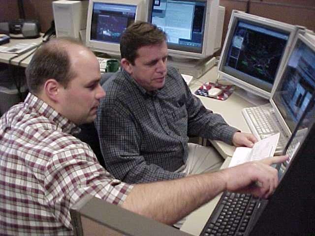
2 The Rundown CIPCO/IEM/KCCI/NWS partnership Who is using your data? IEM Tracker (a.k.a. spam generator) Downloading Data Website Demo Java Viewer Demo

3 Our Partnership Process Feedback NWS IEM ov ed Pr od uc ts pp Su ns Im rt po up pr ts ec s ce vi er oj O pe ra tio Pr as at D or t Custom Data Products KCCI -TV
4 Iowa Environmental Mesonet 411 What does mesonet mean? meso - Spatial scale, net - network Why environmental? We are interested in air quality, water quality and other non-weather datasets Where is Iowa? It is the current state you are in, soon you will all be asleep. Abbreviated 'IEM'
5 More on the IEM Project of the Department of Agronomy at Iowa State University We are data pigs. Look to meet the growing data needs of users in the State and elsewhere. KCCI SchoolNet is one of the many networks that send data to us.
6 Data Flow
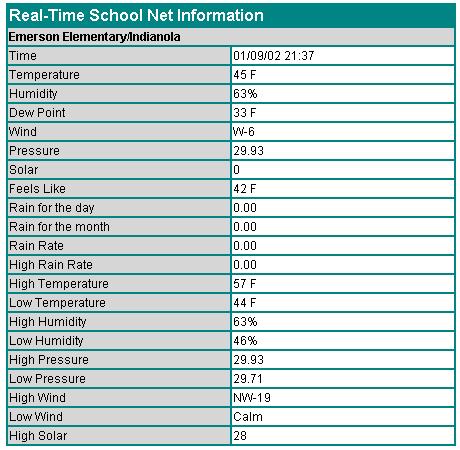
7 Data Formatting C 074 Min 02/17/03 ENE 00MPH 000K 460F 007F 084% 30.08" 00.00"D 00.07"M 00.00"R D 074 Max 02/17/03 ENE 10MPH 050K 460F 021F 100% 30.20" 00.00"D 00.07"M 00.00"R E :01 02/17/03 ENE 03MPH 046K 460F 020F 099% 30.09F 00.00"D 00.07"M 00.00"R Your site produces roughly 6 obs per minute!
8 Converted Data Formats METAR SAUS43 KDMX METAR QJEI Z 05004KT M13/M14 A3009 RMK T P = Comma Delimited SAEI4,2003/02/17 15:35:00,-11.7, 13.3,2,180,0.0,0.0,30.09 SHEF.B DMX 0221 C DH22/TA/PPH/PPT/PPQRS/PPDRS/PCIRP SADI4 35 / 0.00 / 0.00 / 0.00 / 0.00 / 0.68
9 SchoolNet8 Data Users

10 KCCI uses it!
11 SchoolNet8 Data Users Storm Prediction Center [SPC] Norman, Oklahoma In charge of providing timely forecasts of extreme weather. Use schoolnet8 data to help identify mesoscale boundaries critical in severe weather forecasting
12 SchoolNet8 Data Users River Forecast Center [RFC] Chanhassen, MN In charge of analyzing and forecasting river flood conditions. Hydrological data. Use SchoolNet8 precipitation totals for their water analysis. The SchoolNet8 network has doubled the hydrological observing sensors in Central Iowa.
13 SchoolNet8 Data Users Forecast Systems Laboratory [FSL] Boulder, Colorado Data collected under the MADIS project. Data is used in very detailed and heavily quality controlled surface analysis programs. This data is then included in some operational weather forecasting models run in D.C.
14 SchoolNet8 Data Users National Weather Service [NWS] Des Moines, IA Receiving data in three different formats Use data in hydrological applications, surface analysis, severe weather awareness, winter weather awareness. Are automatically alerted of 50+ MPH wind gusts and heavy rainfall.
15 NWS Auto Alerts Previously, KCCI would have to manually relay observations to the weather service. Now, the IEM automatically generates warnings that appear on forecaster workstations.

16 NWS AWIPS alerts
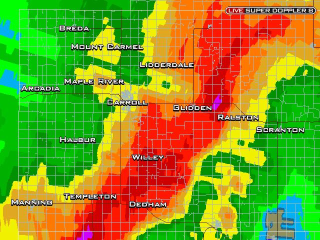
17 18 June 2003: Nevada SchoolNet A good example of how data from your school can make a difference in your community.

18 RADAR Loop
19 At 1:34 PM, an alert is generated ======================= KCCI SchoolNet8 Wind Gust Alert Time: 01:34 pm June 2003 Site: NEVADA COMMUN Gust: 58 MPH
20 At 1:37 PM, the NWS warns 137 PM CDT WED JUN THE NATIONAL WEATHER SERVICE IN DES MOINES HAS ISSUED A * SEVERE THUNDERSTORM WARNING FOR... EASTERN STORY COUNTY IN CENTRAL IOWA * UNTIL 230 PM CDT 7 MILES WEST OF COLLINS AROUND 150 PM AND NEAR MAXWELL AROUND 155 PM. DAMAGING WINDS OF 60 TO 70 MILES AN HOUR ARE LIKELY IN THE WARNED AREA. THE KCCI SCHOOLNET SITE IN NEVADA REPORTED 58 MPH WINDS AT 134 PM.
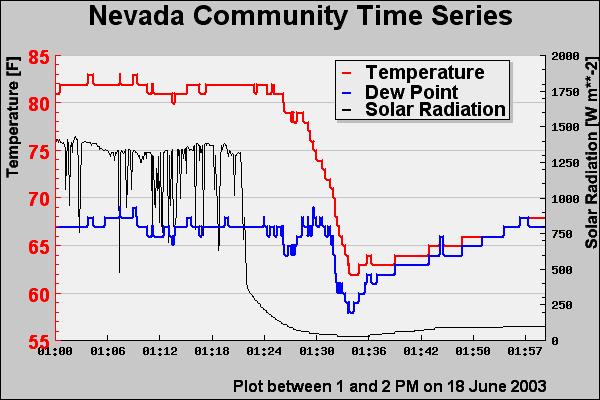
21 Temperature Trace

22 Wind Trace

23 Pressure/Rainfall Trace
24 IEM Tracker
25 IEM Tracker System to manage metadata about sites Most of you have probably gotten the s from Iowa Environ Mesonet Since the system came online on 25 June 2002, it has generated over 11,000 tickets Most of these tickets are generated from the automated data tracking system
26 What are offline alerts? When online, your site is streaming observations to the Internet at roughly 6 obs per minute. A process on the IEM server monitors this feed and once the most recent ob is 30 minutes old, a trouble ticket is generated and site contacts are ed.
27 Understanding the Ticket *** IEM TRACKER REPORT *** ID : SCOI4 Station Name : COLO ELEM _ COLO Status Change : [OFFLINE] Site is NOT reporting to the IEM Trouble Ticket# : 3704 Last Observation : :53:00.00
28 More about the tickets Probably 50% of the tickets are network related and out of your hands. 5% of the tickets are responded to with further information IEM tracker has improved network performance for each of the networks it monitors.
29 SchoolNet8 Performance Fewest Tickets Most Tickets 5 Bedford 89 Colo 5 Bloomfield 88 Adel 10 NW Webster 70 Panora Highest Online % 93 Jefferson Scranton 92 Afton 92 River Woods DSM Lowest Online % 61 Clarion 69 Murray 73 Pella
30 Keep those clocks set! Data on the IEM website is given a timestamp of the current IEM system clock and NOT the timestamp on the observation. The precipitation counters are adversely impacted by drifting clocks. It makes it a bit more difficult to calculate daily precipitation totals.
31 Download Data Archive
32 Data Archives 1 minute data archive exists since 12 Feb 2002, this is available on-line Since 10 Jul 2002, every observation is archived, but not readily available. I can fill these data requests if you send me an .
33 8/ 10 /0 8/ :0 0 /0 2 8/ 10 2:0 0 /0 2 8/ 10 4:0 0 /0 2 8/ 10 6:0 0 / 8/ /0 :00 8/ 2 1 0: /0 2 8/ 10 12: 00 /0 2 8/ 10 14: 00 /0 2 8/ 10 16: 00 /0 2 8/ 10 18: 00 /0 2 8/ 10 20: 00 / :0 0 Hourly data Temperature Dew Point Solar Radation
34 8/10/02 23:04 8/10/02 21:47 8/10/02 20:29 8/10/02 19:12 8/10/02 17:55 8/10/02 16:38 8/10/02 15:22 8/10/02 14:05 8/10/02 12:48 8/10/02 11:31 8/10/02 10:14 8/10/02 8:57 8/10/02 7:41 8/10/02 6: /10/02 5:07 8/10/02 3:50 8/10/02 2:33 8/10/02 1:16 8/10/02 0:00 Minute Data Temperature Dew Point Solar Radation
35 8/10/02 10:29 8/10/02 10:18 8/10/02 10:08 8/10/02 9:57 8/10/02 9:47 8/10/02 9:36 8/10/02 9:26 8/10/02 9:15 8/10/02 9:05 8/10/02 8:54 8/10/02 8:44 8/10/02 8:33 8/10/02 8:23 8/10/02 8: /10/02 8:02 8/10/02 7:51 8/10/02 7:41 8/10/02 7:30 10 second data! Temperature Dew Point Solar Radation
36 WWW Resources

37 Circa 2001

38 Circa 2002

39 Circa 2003


40 Which website is which?


41 Questions? Daryl Herzmann 3010 Agronomy Hall Ames, IA Cell:
KCCI SchoolNet8 and the Iowa Mesonet
 KCCI SchoolNet8 and the Iowa Mesonet Daryl Herzmann Iowa State University Iowa Environmental Mesonet 411 What does mesonet mean? meso - Spatial scale, net - network Why environmental? We are interested
Weather can change quickly...are you on top of the changes?
 Weather Access Bob Glancy NOAA National Weather Service, Boulder, CO Near Cedar Point, CO May 9, 2004 Weather can change quickly...are you on top of the changes? National Weather Service Local offices:
Deploying the Winter Maintenance Support System (MDSS) in Iowa
 in Iowa") Deploying the Winter Maintenance Support System (MDSS) in Iowa Dennis A. Kroeger Center for Transportation Research and Education Iowa State University Ames, IA 50010-8632 kroeger@iastate.edu Dennis Burkheimer
Deploying the Winter Maintenance Support System (MDSS) in Iowa Dennis A. Kroeger Center for Transportation Research and Education Iowa State University Ames, IA 50010-8632 kroeger@iastate.edu Dennis Burkheimer
National Weather Service Flood Forecast Needs: Improved Rainfall Estimates
 National Weather Service Flood Forecast Needs: Improved Rainfall Estimates Weather Forecast Offices Cleveland and Northern Indiana Ohio River Forecast Center Presenter: Sarah Jamison, Service Hydrologist
CLIMATE CHANGE ADAPTATION BY MEANS OF PUBLIC PRIVATE PARTNERSHIP TO ESTABLISH EARLY WARNING SYSTEM
 CLIMATE CHANGE ADAPTATION BY MEANS OF PUBLIC PRIVATE PARTNERSHIP TO ESTABLISH EARLY WARNING SYSTEM By: Dr Mamadou Lamine BAH, National Director Direction Nationale de la Meteorologie (DNM), Guinea President,
The illusion of Storm Based Warnings. Daryl Herzmann Iowa State University
 The illusion of Storm Based Warnings Daryl Herzmann Iowa State University Don t agree with something you see? Do what this guy did! I ll act indignant and ignore you. Why am I so bitter? 1. Old Age 2.
The Climate of Marshall County
 The Climate of Marshall County Marshall County is part of the Crosstimbers. This region is a transition region from the Central Great Plains to the more irregular terrain of southeastern Oklahoma. Average
Charles Kuster Leadville, CO. Personal Overview
 Charles Kuster Leadville, CO Personal Overview Personal Overview Charles Kuster Leadville, CO OU to study meteorology Charles Kuster Leadville, CO Personal Overview OU to study meteorology Graduated in
IEM Potpourri. Daryl Herzmann. (combine a bunch of unrelated stuff and see if it smells good at the end)
") IEM Potpourri (combine a bunch of unrelated stuff and see if it smells good at the end) Daryl Herzmann Department of Agronomy, ISU akrherz@iastate.edu The next 50 minutes of your life will consist of:
IEM Potpourri (combine a bunch of unrelated stuff and see if it smells good at the end) Daryl Herzmann Department of Agronomy, ISU akrherz@iastate.edu The next 50 minutes of your life will consist of:
The Kentucky Mesonet: Entering a New Phase
 The Kentucky Mesonet: Entering a New Phase Stuart A. Foster State Climatologist Kentucky Climate Center Western Kentucky University KCJEA Winter Conference Lexington, Kentucky February 9, 2017 Kentucky
The Climate of Pontotoc County
 The Climate of Pontotoc County Pontotoc County is part of the Crosstimbers. This region is a transition region from the Central Great Plains to the more irregular terrain of southeast Oklahoma. Average
CoCoRaHS. Community Collaborative Rain, Hail, & Snow Network. Ashley Wolf Meteorologist NWS Green Bay Northeast Wisconsin CoCoRaHS Coordinator
 CoCoRaHS Community Collaborative Rain, Hail, & Snow Network Ashley Wolf Meteorologist NWS Green Bay Northeast Wisconsin CoCoRaHS Coordinator What is CoCoRaHS Who, What, Where and Whys of CoCoRaHS What?
NWS Resources For Public Works
 NWS Resources For Public Works August 28th, 2016 Shawn DeVinny shawn.devinny@noaa.gov Meteorologist National Weather Service Twin Cities/Chanhassen, MN 1 APWA 2016 PWX 8/28/2016 National Weather Service
Center for Transportation Research and Education. Winter Maintenance Operations & Maintenance Decision Support System TRANS 691 Seminar March 5, 2004
 Center for Transportation Research and Education Winter Maintenance Operations & Maintenance Decision Support System TRANS 691 Seminar March 5, 2004 1 Why Winter Maintenance? Weather related traffic accidents
Sources of Hourly Surface Data and Weather Maps for the U.S.
 Sources of Hourly Surface Data and Weather Maps for the U.S. Weather Underground Weather Underground http://www.wunderground.com/history/ maintains a deep archive of hourly reports for around the world.
The Climate of Payne County
 The Climate of Payne County Payne County is part of the Central Great Plains in the west, encompassing some of the best agricultural land in Oklahoma. Payne County is also part of the Crosstimbers in the
A Comparison of Iowa Flash Flood Events and Eight Common Features of Excessive Rainfall for BRITTANY A. KONRADI 1
 1 A Comparison of Iowa Flash Flood Events and Eight Common Features of Excessive Rainfall for 2006-2011 BRITTANY A. KONRADI 1 Mentors: Melinda Beerends 2, Dr. Kristie Franz 1 Department of Geological and
Sources of Hourly Surface Data and Weather Maps for the U.S.
 Sources of Hourly Surface Data and Weather Maps for the U.S. Weather Underground Weather Underground http://www.wunderground.com/history/ maintains a deep archive of hourly reports for around the world.
The Long-lived eastern US tornadic supercell of 20 July 2017
 1. Overview The Long-lived eastern US tornadic supercell of 20 July 2017 By Richard H. Grumm and Elissa A Smith National Weather Service State College, PA A long lived supercell developed near the eastern
The Climate of Bryan County
 The Climate of Bryan County Bryan County is part of the Crosstimbers throughout most of the county. The extreme eastern portions of Bryan County are part of the Cypress Swamp and Forest. Average annual
Texas Statewide Mesonet Network (TexMesonet) Dr. Kantave Greene 11/15/17
 Dr. Kantave Greene 11/15/17") Texas Statewide Mesonet Network (TexMesonet) Dr. Kantave Greene 11/15/17 1 Observe weather features Why Mesonets? Thunderstorms Squall lines Dry-lines Sea breezes Improve weather & flood forecasts Drought
Texas Statewide Mesonet Network (TexMesonet) Dr. Kantave Greene 11/15/17 1 Observe weather features Why Mesonets? Thunderstorms Squall lines Dry-lines Sea breezes Improve weather & flood forecasts Drought
CHAPTER 13 WEATHER ANALYSIS AND FORECASTING MULTIPLE CHOICE QUESTIONS
 CHAPTER 13 WEATHER ANALYSIS AND FORECASTING MULTIPLE CHOICE QUESTIONS 1. The atmosphere is a continuous fluid that envelops the globe, so that weather observation, analysis, and forecasting require international
We Had No Warning An Overview of Available Forecast Products Before and During Severe Weather Events
 We Had No Warning An Overview of Available Forecast Products Before and During Severe Weather Events Two main sources for severe weather info NOAA/NWS Storm Prediction Center (SPC) Convective Outlooks
MAXIMUM WIND GUST RETURN PERIODS FOR OKLAHOMA USING THE OKLAHOMA MESONET. Andrew J. Reader Oklahoma Climatological Survey, Norman, OK. 2.
 J3.14 MAXIMUM WIND GUST RETURN PERIODS FOR OKLAHOMA USING THE OKLAHOMA MESONET Andrew J. Reader Oklahoma Climatological Survey, Norman, OK 1. Introduction It is well known that Oklahoma experiences convective
Severe Weather Watches, Advisories & Warnings
 Severe Weather Watches, Advisories & Warnings Tornado Watch Issued by the Storm Prediction Center when conditions are favorable for the development of severe thunderstorms and tornadoes over a larger-scale
The Climate of Murray County
 The Climate of Murray County Murray County is part of the Crosstimbers. This region is a transition between prairies and the mountains of southeastern Oklahoma. Average annual precipitation ranges from
Memo. I. Executive Summary. II. ALERT Data Source. III. General System-Wide Reporting Summary. Date: January 26, 2009 To: From: Subject:
 Memo Date: January 26, 2009 To: From: Subject: Kevin Stewart Markus Ritsch 2010 Annual Legacy ALERT Data Analysis Summary Report I. Executive Summary The Urban Drainage and Flood Control District (District)
icast: A Severe Thunderstorm Forecasting, Nowcasting and Alerting Prototype Focused on Optimization of the Human-Machine Mix
 icast: A Severe Thunderstorm Forecasting, Nowcasting and Alerting Prototype Focused on Optimization of the Human-Machine Mix 1Cloud Physics and Severe Weather Research Section, Toronto, ON 2Meteorological
The Climate of Seminole County
 The Climate of Seminole County Seminole County is part of the Crosstimbers. This region is a transition region from the Central Great Plains to the more irregular terrain of southeastern Oklahoma. Average
The Climate of Texas County
 The Climate of Texas County Texas County is part of the Western High Plains in the north and west and the Southwestern Tablelands in the east. The Western High Plains are characterized by abundant cropland
SAMPLE. SITE SPECIFIC WEATHER ANALYSIS Wind Report. Robinson, Smith & Walsh. John Smith. July 1, 2017 REFERENCE: 1 Maple Street, Houston, TX 77034
 SAMPLE SITE SPECIFIC WEATHER ANALYSIS Wind Report PREPARED FOR: Robinson, Smith & Walsh John Smith July 1, 2017 REFERENCE: JACK HIGGINS / 4151559-01 1 Maple Street, Houston, TX 77034 CompuWeather Sample
Severe Weather Hazards Are Real
 Severe Weather Hazards Are Real In the past 10 years, more than 40 people have died and dozens more injured as a result of weatherrelated events in Minnesota (not including motor vehicles.) The top severe
Snow Measurement Guidelines for National Weather Service Snow Spotters
 Snow Measurement Guidelines for National Weather Service Snow Spotters National Weather Service Forecast Office Northern Indiana October 2004 Table of Contents Introduction 3 Definitions.. 3 Relaying Real
The Climate of Kiowa County
 The Climate of Kiowa County Kiowa County is part of the Central Great Plains, encompassing some of the best agricultural land in Oklahoma. Average annual precipitation ranges from about 24 inches in northwestern
Colorado State University, Fort Collins, CO Weather Station Monthly Summary Report
 Colorado State University, Fort Collins, CO Weather Station Monthly Summary Report Month: January Year: 2019 Temperature: Mean T max was 47.2 F which is 3.0 above the 1981-2010 normal for the month. This
The Climate of Haskell County
 The Climate of Haskell County Haskell County is part of the Hardwood Forest. The Hardwood Forest is characterized by its irregular landscape and the largest lake in Oklahoma, Lake Eufaula. Average annual
Radar Network for Urban Flood and Severe Weather Monitoring
 Radar Network for Urban Flood and Severe Weather Monitoring V. Chandrasekar 1 and Brenda Philips 2 Colorado State University, United States University of Massachusetts, United States And the full DFW team
Seeley Burn Scar SR-31, Region 4 UDOT Weather Response Summer 2013
 Seeley Burn Scar SR-31, Region 4 UDOT Weather Response Summer 2013 Seeley Burn Scar Information June 26 July 18, 2012 48,050 acres burned Lightning caused fire 8 miles of SR-31 impacted Huntington Creek
Tropical Storm Colin Briefing Last Briefing on this System
 Tropical Storm Colin Briefing Last Briefing on this System NWS WFO Jacksonville, Florida Tuesday, June 07, 2016 6:00 a.m. EDT Tropical Storm Colin s Impacts SE Georgia & North Florida Local Watches & Warnings:
Complete Weather Intelligence for Public Safety from DTN
 Complete Weather Intelligence for Public Safety from DTN September 2017 White Paper www.dtn.com / 1.800.610.0777 From flooding to tornados to severe winter storms, the threats to public safety from weather-related
Introduction to Weather Analytics & User Guide to ProWxAlerts. August 2017 Prepared for:
 Introduction to Weather Analytics & User Guide to ProWxAlerts August 2017 Prepared for: Weather Analytics is a leading data and analytics company based in Washington, DC and Dover, New Hampshire that offers
The Climate of Grady County
 The Climate of Grady County Grady County is part of the Central Great Plains, encompassing some of the best agricultural land in Oklahoma. Average annual precipitation ranges from about 33 inches in northern
APRSWXNET/CWOP - a beneficial partnership of NOAA, Amateur Radio, And Other Good Citizens
 APRSWXNET/CWOP - a beneficial partnership of NOAA, Amateur Radio, And Other Good Citizens Russ Chadwick, KBOTVJ NOAA Forecast Systems Laboratory Boulder, Colorado Abstract APRSWXNET/CWOP is a group of
Monitoring Extreme Weather Events. February 8, 2010
 Monitoring Extreme Weather Events February 8, 2010 Extensive network of over 800 stations across the Prairies Good coverage across entire agriculture production region Network of networks strategy includes
Linked Environments for Atmospheric Discovery: Web Services for Meteorological Research and Education
 Linked Environments for Atmospheric Discovery: Web Services for Meteorological Research and Education What Would YOU Do if These Were About to Occur? What THEY Do to Us!!! Each year in the US, mesoscale
Arizona Climate Summary
 Arizona Climate Summary April 2014 Summary of conditions for March 2014 March 2014 Temperature and Precipitation Summary March 1 st 16 th : We started off the month of March with a significant precipitation
Kentucky Weather Hazards: What is Your Risk?
 Kentucky Weather Hazards: What is Your Risk? Stuart A. Foster State Climatologist for Kentucky 2010 Kentucky Weather Conference Bowling Green, Kentucky January 16, 2010 Perspectives on Kentucky s Climate
Weather versus Climate: What is the difference? Sources of Weather Information
 Joel O. Paz, Extension Agrometerologist and Gerrit Hoogenboom, Professor & REI Coordinator Department of Biological and Agricultural Engineering Weather versus Climate: What is the difference? The difference
Issued by: National Weather Service San Joaquin Valley - Hanford CA. Issue time: 409 AM PST Wed Jan
 Forecast Information Location: New_Exchequer_Dam Updated: January 16, 2019, 11:45 am NWS Weather Discussion: Issued by: National Weather Service San Joaquin Valley - Hanford CA Issue time: 409 AM PST Wed
IWT Scenario 2 Integrated Warning Team Workshop National Weather Service Albany, NY October 31, 2014
 IWT Scenario 2 Integrated Warning Team Workshop National Weather Service Albany, NY October 31, 2014 09 10 11 12 13 Scenario 2 Timeline December 9-13 Tue Wed Thu Fri Sat Tue, Dec. 9 @ 5 am 2014 2014 2014
Unit 5: NWS Hazardous Weather Products. Hazardous Weather and Flooding Preparedness
 Unit 5: NWS Hazardous Weather Products Objectives Describe the mission of the NWS Describe the basic organizational structure of the NWS Explain the purpose of various NWS products Explain how Probability
LOCAL CLIMATOLOGICAL DATA Monthly Summary July 2013
 Deg. Days Precip Ty Precip Wind Solar Hu- Adj. to Sea Level mid- ity Avg Res Res Peak Minute 1 fog 2 hvy fog 3 thunder 4 ice plt 5 hail 6 glaze 7 duststm 8 smk, hz 9 blw snw 1 2 3 4A 4B 5 6 7 8 9 12 14
Significant Flooding Expected
 Significant Flooding Expected Decision Support Briefing #5 As of: 9:00 AM September 14, 2018 What Has Changed? Flash Flood Watch now in effect for part of area, will be expanded later today 9/14/2018 9:23
Tropical Weather Briefing
 Tropical Weather Briefing August 28, 2012 700 AM CDT National Weather Service Weather Forecast Office Slidell, LA Current Satellite Tropical Storm Isaac Watches/Warnings Tropical Storm Isaac Track Guidance
DAVE LEVIN AARON SCHULMAN
 YOUNDO LEE DAVE LEVIN NEIL SPRING RAMAKRISHNA PADMANABHAN University of Maryland AARON SCHULMAN Stanford Weather causes residential link failures Lightning destroys equipment and causes interference Water
IEM Update: From pollen to rivers to pavements to soils and a whole lot more. Daryl Herzmann ISU Meteorology Seminar 10 Oct 2006
 IEM Update: From pollen to rivers to pavements to soils and a whole lot more Daryl Herzmann ISU Meteorology Seminar 10 Oct 2006 Motivation for the IEM Spring 2001: To build a centralized clearing house
Event Date(s): 12:01 AM December 8th, 2013 through 2:00 PM December 12th, 2013
: 12:01 AM December 8th, 2013 through 2:00 PM December 12th, 2013") CLAIM Location: 123 Sample Road, Duluth, MN Event Date(s): 12:01 AM December 8th, 2013 through 2:00 PM December 12th, 2013 Prepared for: Sample Enterprises, Inc. Scope: Review best available records of
CLAIM Location: 123 Sample Road, Duluth, MN Event Date(s): 12:01 AM December 8th, 2013 through 2:00 PM December 12th, 2013 Prepared for: Sample Enterprises, Inc. Scope: Review best available records of
The Impact of 2007 Atlantic Hurricane Season on Dominica
 The Impact of 2007 Atlantic Hurricane Season on Dominica DOMINICA November 2007 Main Activities Freak Twister on June 21st 2007. Hurricane Dean on August 16th to 17th 2007 Active Tropical Wave on September
WEATHER SYSTEMS IMPACTING THE CAYMAN ISLANDS Prepared by the staff of the Cayman Islands National Weather Service
 WEATHER SYSTEMS IMPACTING THE CAYMAN ISLANDS 2008 Prepared by the staff of the Cayman Islands National Weather Service TROPICAL STORM DOLLY Formed 194 miles west of Grand Cayman July 19 th. The tropical
A Cloud-Based Flood Warning System For Forecasting Impacts to Transportation Infrastructure Systems
 A Cloud-Based Flood Warning System For Forecasting Impacts to Transportation Infrastructure Systems Jon Goodall Associate Professor, Civil and Environmental Engineering Associate Director, Link Lab April
SAMPLE. SITE SPECIFIC WEATHER ANALYSIS Wind Report. Robinson, Smith & Walsh. John Smith REFERENCE:
 SAMPLE SITE SPECIFIC WEATHER ANALYSIS Wind Report PREPARED FOR: Robinson, Smith & Walsh John Smith REFERENCE: JACK HIGGINS / 4151559-01 CompuWeather Sample Report Please note that this report contains
ERTH 365 Homework #2: Hurricane Harvey. 100 points
 ERTH 365 Homework #2: Hurricane Harvey 100 points Due by 6pm, Tuesday 30 October 2018, ELECTRONIC SUBMISSON BY EMAIL ONLY BY 6PM (send to klevey@sfsu.edu) (acceptable formats: MS Word, Google Doc, plain
Thunderstorm Forecasting and Warnings in the US: Applications to the Veneto Region
 Thunderstorm Forecasting and Warnings in the US: Applications to the Veneto Region Bill Conway Vice President Weather Decision Technologies Norman, Oklahoma, USA Andrea Rossa ARPAV Lead Scientist Centre
Arizona Climate Summary
 Arizona Climate Summary March 2014 Summary of conditions for February 2014 February 2014 Temperature and Precipitation Summary February 1 st 16 th : We started off the month of February with some moisture
Low-end derecho of 19 August 2017
 Low-end derecho of 19 August 2017 By Richard H. Grumm and Charles Ross National Weather Service State College, PA 1. Overview A cluster of thunderstorms developed in eastern Ohio around 1800 UTC on 19
National Public Weather and Warning Services in the Swaziland Meteorological Service Dennis S.Mkhonta /
 National Public Weather and Warning Services in the Swaziland Meteorological Service Dennis S.Mkhonta dennis.mkhonta@gmail.com / dennis@swazimet.gov.sz Introduction Swaziland s geographical position exposes
University of Maryland. Tuesday, February 7, 12
 AARON SCHULMAN NEIL SPRING University of Maryland Measuring weather-related failures Identify residential IPs that will be subject to weather Ping before, during, and after a weather event Analyze the
Friday, September 7, :30 a.m. EDT
 Friday, September 7, 2018 8:30 a.m. EDT Tropical Depression Gordon - Final Situation (Advisory #20 as of 5:00 a.m. EDT) Located 30 miles S of Little Rock, AR Moving N at 5 mph; this motion expected to
 Hazard Warnings GE 4150 Natural Hazards September 17, 2007 http://www.sdr.gov/ndis_rev_oct27.pdf Sorensen, J.H. (2000) Hazard warning systems: Review of 20 years of progress. Natural Hazards Review, May,
BARON END-TO-END HYDROLOGICAL MODELING SOLUTION NOW AVAILABLE IN NEW BARON LYNX DISPLAY
 4930 Research Drive Huntsville, AL 35805 (256)-881-8811 www.baronweather.com FOR IMMEDIATE RELEASE BARON END-TO-END HYDROLOGICAL MODELING SOLUTION NOW AVAILABLE IN NEW BARON LYNX DISPLAY Powerful scientific
Dr. Amanda Schroeder. NWS Weather Forecast Office Fort Worth, TX. Sustainable Urban Water Workshop University of Texas-Arlington June 4-5, 2015
 Dr. Amanda Schroeder NWS Weather Forecast Office Fort Worth, TX Sustainable Urban Water Workshop University of Texas-Arlington June 4-5, 2015 Outline Communicating the message - official Flood and Flash
National Weather Service Greenville-Spartanburg, Forecast Office
 National Weather Service Greenville-Spartanburg, Forecast Office CoCoRaHS Presentation: NC CERT Conference May, 2017 Introduction- who we are. Federal Agency Within the U.S. Dept. of Commerce Introduction-
Tropical Update. 5 AM EDT Tuesday, September 12, 2017 Post-Tropical Cyclone Irma, Hurricane Jose, & Tropical Wave (10%)
") Tropical Update 5 AM EDT Tuesday, September 12, 2017 Post-Tropical Cyclone Irma, Hurricane Jose, & Tropical Wave (10%) This update is intended for government and emergency response officials, and is provided
Tropical Update 5 AM EDT Tuesday, September 12, 2017 Post-Tropical Cyclone Irma, Hurricane Jose, & Tropical Wave (10%) This update is intended for government and emergency response officials, and is provided
London Heathrow Field Site Metadata
 London Heathrow Field Site Metadata Field Site Information Name: Heathrow src_id (Station ID number): 708 Geographic Area: Greater London Latitude (decimal ): 51.479 Longitude (decimal ): -0.449 OS Grid
The Hydrologic Cycle: How Do River Forecast Centers Measure the Parts?
 The Hydrologic Cycle: How Do River Forecast Centers Measure the Parts? Greg Story Meteorologist National Weather Service Fort Worth, TX Overview n Introduction What is the mission of an RFC? n The Hydrologic
Significant Coastal Storm Today through Thursday, 11/7-8. Weather Briefing
 Significant Coastal Storm Today through Thursday, 11/7-8 Weather Briefing Prepared 10:00 am EST Wednesday, November 7, 2012 Presented by Gary Conte, Warning Coordination Meteorologist NOAA s National Weather
2013 Tornado and Severe Weather Awareness Drill
 2013 Tornado and Severe Weather Awareness Drill Scheduled for Thursday April 18, 2013 The 2013 Tornado Drill will consist of a mock tornado watch and a mock tornado warning for all of Wisconsin. This is
NWS Resources For School Districts
 NWS Resources For School Districts January 23rd, 2017 Shawn DeVinny shawn.devinny@noaa.gov Meteorologist National Weather Service Twin Cities/Chanhassen, MN Outline Watches/Warnings/Advisories Example
Observations from Plant City Municipal Airport during the time period of interest are summarized below:
 December 3, 2014 James A. Murman Barr, Murman & Tonelli 201 East Kennedy Boulevard Suite 1700 Tampa, FL 33602 RE: Case No. 166221; BMT Matter No.: 001.001007 Location of Interest: 1101 Victoria Street,
Hurricane Harvey: SE Texas Impacts. 10 AM CDT UPDATE Saturday, August 26, 2017 Prepared by: Dan Reilly, Brian Kyle
 Hurricane Harvey: SE Texas Impacts 10 AM CDT UPDATE Saturday, August 26, 2017 Prepared by: Dan Reilly, Brian Kyle Latest Observations and Radar Hurricane Harvey centered near Victoria and weakening Wind
P1.7 FORECASTER USAGE PATTERNS OF AWIPS D2D AND GFESUITE DURING 2005
 P1.7 FORECASTER USAGE PATTERNS OF AWIPS D2D AND GFESUITE DURING 2005 Leigh K. Cheatwood* and William F. Roberts NOAA Research-Earth System Research Laboratory, Boulder, CO [In collaboration with the Cooperative
Arizona Climate Summary June 2013
 Arizona Climate Summary June 2013 Summary of conditions for May 2013 May 2013 Temperature and Precipitation Summary May 1 st 16 th : May began with above normal daily temperatures and breezy conditions
Aeronautical Information Service
 , St. Maarten and The Netherlands EFFECTIVE DATE: 31 MARCH 2016 KNMI Meteorological Services Information for TNCB, TNCE and TNCS Page: GEN 2.7-1 Sunrise / sunset tables 1. The tables on the following pages
SPEARFISH FIRE DEPARTMENT POLICIES AND PROCEDURES
 SPEARFISH FIRE DEPARTMENT POLICIES AND PROCEDURES Page 1 of 5 Volume: Operation Section: 20.00 Number: 20.09 Subject: Weather Watches, Warnings, Advisory s and Spotter Activation Date Issued: 28 March
THE SKYWARN NET SCRIPT FOLLOWS SEVERE STORM-SUMMER
 WATCH mode READ EVERY 15 MINUTES on 146.94 Repeater Is the frequency in use? (to break into a conversation, use the Proword SKYWARN ) National Weather Service San Antonio/Austin. All SKYWARN spotters are
P1.11 NWS CLOUD-TO-GROUND LIGHTNING THREAT ANALYSIS. Nicole M. Kempf* and Glenn E. Wiley National Weather Service, Tulsa, Oklahoma
 P1.11 NWS CLOUD-TO-GROUND LIGHTNING THREAT ANALYSIS Nicole M. Kempf* and Glenn E. Wiley National Weather Service, Tulsa, Oklahoma 1. INTRODUCTION The 25 million cloud-to-ground (CG) lightning flashes each
CASA WX DFW URBAN DEMONSTRATION NETWORK
 CASA WX DFW URBAN DEMONSTRATION NETWORK Goals Background on Regional CASA WX Project Explain the capabilities, structure of the Radar Network Present the CASA WX DFW Test Bed will be rolled out Describe
Unidata Policy Committee NOAA/NWS Update
 Unidata Policy Committee NOAA/NWS Update October 27, 2011 LeRoy Spayd Chief Training Division Office of Climate, Water, and Weather Services NOAA s National Weather Service 1 2 Outline NOAA Budget NOAA
DEPARTMENT OF EARTH & CLIMATE SCIENCES SAN FRANCISCO STATE UNIVERSITY. Metr Fall 2014 Test #1 September 30, 2014
 DEPARTMENT OF EARTH & CLIMATE SCIENCES SAN FRANCISCO STATE UNIVERSITY NAME Metr 302.02 Fall 2014 Test #1 September 30, 2014 200 pts (4 pts each answer) Part I. Surface Chart Interpretation. Questions 1
SPC Mission Statement. Tornado in Miami, FL Photo: Miami Herald. What is SPC s Responsibility? More SPC Products. SPC Products
 The NOAA/NWS Storm Prediction Center Adapted from a presentation to UNCA atmospheric science students by David Imy SPC Mission Statement SPC exists to protect life and property of the American people through
Kane County Amateur Radio Emergency Service
 This script is to be used when severe weather is approaching or has reached Kane County. The script is divided into three parts. Part One is for use when the National Weather Service has issued a WATCH
Daily Operations Briefing Friday, May 8, :30 a.m. EDT
 Daily Operations Briefing Friday, May 8, 2015 8:30 a.m. EDT Significant Activity: May 7-8 Significant Events: Severe weather Central/Southern Plains Tropical Activity: Atlantic: Subtropical Storm Ana Western
Real-Time Meteorological Gridded Data: What s New With HEC-RAS
 Real-Time Meteorological Gridded Data: What s New With HEC-RAS Acquisition and Application of Gridded Meteorological Data in Support of the USACE s Real-Time Water Management Mission Fauwaz Hanbali, Tom
New Forecast Section. connection. Volume 3 Issue 4 April 2012
 Volume 3 Issue 4 April 2012 connection www.mesonet.org New Forecast Section Spring has arrived, and so has storm season. For many, that means monitoring the weather and forecast more. To help users prepare
COOP Modernization: NOAA s Environmental Real-time Observation Network in New England, the Southeast and Addressing NIDIS in the West
 COOP Modernization: NOAA s Environmental Real-time Observation Network in New England, the Southeast and Addressing NIDIS in the West Ken Crawford NWS Office of Science and Technology Special Presentation
LOCAL CLIMATOLOGICAL DATA Monthly Summary September 2016
 Deg. Days Precip Ty Precip Wind Solar Hu- Adj. to Sea Level mid- ity Avg Res Res Peak 2 Minute 1 fog 2 hvy fog 3 thunder 4 ice plt 5 hail 6 glaze 7 duststm 8 smk, hz 9 blw snw 1 2 3 4A 4B 5 6 7 8 9 11
University of Maryland. Monday, November 7, 11
 AARON SCHULMAN NEIL SPRING University of Maryland Residential links may fail Links are not redundant Equipment updates are rare Equipment operates in an uncontrolled environment photo credit: Ode Street
J4.6 UNDERSTANDING THE MESOSCALE PROCESSES OF FLASH FLOODS: IMPACTS ON PREDICTION AND RESPONSE
 J4.6 UNDERSTANDING THE MESOSCALE PROCESSES OF FLASH FLOODS: IMPACTS ON PREDICTION AND RESPONSE Matthew Kelsch Cooperative Program for Operational Meteorology, Education and Training (COMET ) University
Real-Time Flood Forecasting Modeling in Nashville, TN utilizing HEC-RTS
 Real-Time Flood Forecasting Modeling in Nashville, TN utilizing HEC-RTS Brantley Thames, P.E. Hydraulic Engineer, Water Resources Section Nashville District, USACE August 24, 2017 US Army Corps of Engineers