CEGRN Consortium. A first campaign took place in Since 1997, each two years, a weekly campaign has been observed, normally in June.
|
|
|
- Hilda Pope
- 5 years ago
- Views:
Transcription
1 CEGRN 2015 Campaign A. Caporali (1), J. Zurutuza (1), O. Khoda (2), G. Stangl (3), M. Becker (4), M. Bertocco (1), L. Gerhatova (5), M. Mojzes (5), M. Mulic (6), Yu. Stopkhay (7), C. Nagorneac (8), A. Mihailov (8), S. Lazić (9), J. Papčo (5), B. Stopar (10) (1) University of Padua, Italy; (2) Main Astronomical Observatory National Academy of Sciences of Ukraine, Kiev, Ukraine; (3) Space Research Institute, Austrian Academy of Sciences, Graz, Austria; (4) Technical University of Darmstadt, Germany; (5) Slovak University of Technology, Bratislava, Slovakia; (6) University of Sarajevo, Bosnia and Herzegovina; (7) System Solutions, Kiev, Ukraine; (8) Institute of Geodesy, Engineering Research and Cadastre "INGEOCAD", Chisinau, Moldova; (9) Republic Geodetic Authority, Belgrade, Serbia; (10) University of Ljubljana, Slovenia
2 CEGRN Consortium The CEGRN Consortium serves the operation, maintenance and development of the CEGRN network, coordinates the measurements, data processing, and collaboration in different research topics. The Consortium also serves as the institutional background of the CERGOP-2/Environment Project, supported by the EU 5th Framework Programme under contract EVK2-CT A first campaign took place in Since 1997, each two years, a weekly campaign has been observed, normally in June.
3 Motivation and Goals (extract from the EUREF CEGRN MoU signed in Chisinau, 2011) 3. Objectives The objective of this Memorandum of Understanding is, in general, to create the conditions to facilitate the data exchange and to promote the increase in the co-operation between the two parties, for the benefit of both, and in particular, to facilitate the densification of the European GNSS network for reference frame definition and geokinematical applications. It is expected that a closer co-operation between EUREF and CEGRN will increase the level of support to the IAG Dense Velocity Field Project, and the availability of a combined solution with respect to a denser network. Moreover, the co-operation will contribute to: provide better and more consistent data for geokinematics, by the optimization of guidelines for approval of networks with position and velocities and the improvement of offset treatment in time series; stimulate reprocessing of old EPN data, taking into account the foreseen realization of CEGRN 2011 and the completion of the reprocessing of the EPN; involve more nations into the INSPIRE initiative, in particular with the CRS (Coordinate Reference Systems) Implementing Rules.
4 CEGRN campaigns CAMPAIGN PERIOD COUNTRIES SITES CEGRN' May, CEGRN'95 29 May 3 June, CEGRN' June, CEGRN' June, CEGRN' June, (extended network) 57 (29P+28E) CEGRN' June, (extended network) 51 (28P+23E) CEGRN' June, (extended network) 51 (28P+23E) CEGRN' June, (extended network) 94 CEGRN' June, 2006 only CGPS 44 CEGRN' June, (extended network) 95 CEGRN' June, (extended network) 85 CEGRN' June, (extended network) 74 CEGRN' June, CEGRN' June, (UPA+MAO)

5 CEGRN 2015 stations (22 UKR stations removed from the list)
6 CEGRN 2015 Network
7 Processing of a weekly campaign (EUREF guidelines) EPN_A Class stations A priori coordinates RINEX files Prepare data Daily GNSS analysis Campaign weekly stacking (MC) Remove oultiers Check residuals Export weekly normal equations, coordinates, Orbits, ERP: repro2 PCVs, DCBs, HOI,
8 Stacking of weekly campaigns (EUREF guidelines) EPN_A Class stations A priori coordinates and velocities Normal equations Prepare data Remove oultiers Add setups of CEGRN sites (STA) Multiyear stacking (MC on coordinates and velocities constrained) Check residuals Final products: Coordinates, velocities, SNX file, STA file to introduce set ups according to EPN_A C1830
9 CEGRN 2015 Solution The CEGRN 2015 Solution is a combination of two solutions at the NEQ level. 1. UPA University of Padua, Italy: A. Former CEGRN network. B. 32 new stations in the Western Ukraine. C. 2 new sites in BIH. D. 6 new Moldavian sites. 2. MAO Main Astronomical Observatory of the National Academy of Sciences of Ukraine, Kiev, Ukraine (stations located in Ukraine and in the Eastern Europe).
10 Weekly results (mean repeatibilities) Repeatibility (mm) Computed Sites N E U CEGRN CEGRN CEGRN CEGRN CEGRN CEGRN CEGRN CEGRN CEGRN CEGRN CEGRN 2015 (UPA) CEGRN 2015 (MAO) REPRO2 implies consistent quality for years GLONASS was included Guidelines for densification strictly implemented Class A EPN sites for datum definition; solution numbers of EPN_A and B sites implemented
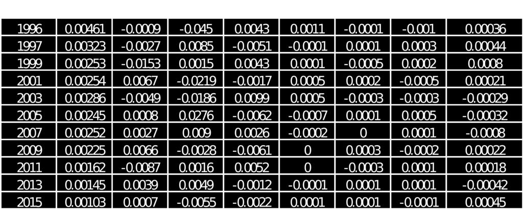
11 UPA vs MAO: Helmert Transformation Parameters With Respect to Combined Solution
12 Cummulative results (combined vs individual)
 of proposed class")
13 Horizontal Velocities (ETRF2000) of proposed class A sites
14 Vertical Velocities of proposed class A sites
15 Conclusions (I) We have completed 12 CEGRN campaigns bringing data spanning DOMES numbers and IGS log files are required for number of CEGRN sites. Increasing data in 2015 thanks to Ukraine, Moldova, and Serbia contributed new sites. The velocities of old CEGRN sites become more reliable and more accurate velocities from the Ukrainian, Moldovian, and Serbian sites are expected in the near future. Likewise for Bosnia and Herzegovina, for example, that contributed with considerable number of stations in 2013.
16 Conclusions (II) Grateful for successful cooperation with the Main Astronomical Observatory of the National Academy of Sciences of Ukraine (Kiev, Ukraine). We acknowledge to the System Solutions (Kiev, Ukraine), the Institute of Geodesy, Engineering Research and Cadastre "INGEOCAD" (Chisinau, Moldova), and Republic Geodetic Authority (Belgrade, Serbia) for providing data for new GNSS stations.
MEMORANDUM OF UNDERSTANDING
 MEMORANDUM OF UNDERSTANDING between A: EUREF, the Reference Frame Sub-Commission for Europe of the International Association of Geodesy (IAG) and B: EUMETNET, the Network of European Meteorological Services.
THREE SEASONAL BEHAVIOUR OF THE BALKAN PENINSULA GNSS PERMANENT STATIONS FROM GPS SOLUTIONS
 Доклади на Българската академия на науките Comptes rendus de l Académie bulgare des Sciences Tome 66, No 1, 2013 GEOPHYSIQUE Sismologie THREE SEASONAL BEHAVIOUR OF THE BALKAN PENINSULA GNSS PERMANENT STATIONS
APPLICATION OF SATELLITE NAVIGATION SYSTEMS IN GEODETIC AND GEODYNAMIC PROGRAMMES OF THE CEI (Central European Initiative)
") APPLICATION OF SATELLITE NAVIGATION SYSTEMS IN GEODETIC AND GEODYNAMIC PROGRAMMES OF THE CEI (Central European Initiative) Janusz Sledzinski International Coordinator of the CEI WG&ST Section C Geodesy
APPLICATION OF SATELLITE NAVIGATION SYSTEMS IN GEODETIC AND GEODYNAMIC PROGRAMMES OF THE CEI (Central European Initiative) Janusz Sledzinski International Coordinator of the CEI WG&ST Section C Geodesy
Publ. Astron. Obs. Belgrade No. 91 (2012), REALIZATION OF ETRF2000 AS A NEW TERRESTRIAL REFERENCE FRAME IN REPUBLIC OF SERBIA
, REALIZATION OF ETRF2000 AS A NEW TERRESTRIAL REFERENCE FRAME IN REPUBLIC OF SERBIA") Publ. Astron. Obs. Belgrade No. 91 (2012), 199-206 Contributed paper REALIZATION OF ETRF2000 AS A NEW TERRESTRIAL REFERENCE FRAME IN REPUBLIC OF SERBIA D. BLAGOJEVIĆ and V. VASILIĆ Faculty of Civil Engineering,
Publ. Astron. Obs. Belgrade No. 91 (2012), 199-206 Contributed paper REALIZATION OF ETRF2000 AS A NEW TERRESTRIAL REFERENCE FRAME IN REPUBLIC OF SERBIA D. BLAGOJEVIĆ and V. VASILIĆ Faculty of Civil Engineering,
Contribution of CERGOP-2/Environment project to geokinematics of Central Europe
 Contribution of CERGOP-2/Environment project to geokinematics of Central Europe J. Hefty, A. Caporali and the CERGOP team: M. Becker, I. Fejes, L. Gerhatova, D. Ghitau, Gy. Grenerczy, D. Medac, G. Milev,
Status Report on the Working Group on "European Dense Velocities" Simon Lutz, Elmar Brockmann and members of the EUREF Working Group
 Status Report on the Working Group on "European Dense Velocities" Simon Lutz, Elmar Brockmann and members of the EUREF Working Group Outline Introduction Contributing solutions First results from the combination
Data base of Italian velocities and strain rates at permanent GNSS sites. A. Caporali, M. Bertocco, J. Zurutuza, University of Padova
 Data base of Italian velocities and strain rates at permanent GNSS sites A. Caporali, M. Bertocco, J. Zurutuza, University of Padova Outlook Part 1: GNSS data reduction and organization Italian permanent
SESSION 1.2 REGIONAL AND NATIONAL REFERENCE SYSTEMS. Rome
 SESSION 1.2 REGIONAL AND NATIONAL REFERENCE SYSTEMS João Agria Torres International Association of Geodesy (jatorres@iol.pt) 1 SUMMARY 8 About Sub-commission 1.3 Regional Reference Frames 8 Similarity
Dealing with significant differential tectonic plate velocities within an RTK-network: The case of HEPOS
 Dealing with significant differential tectonic plate velocities within an RTK-network: The case of HEPOS M. Gianniou, E. Mitropoulou, I. Stavropoulou National Cadastre and Mapping Agency S.A. Mesogion
Realizing a geodetic reference frame using GNSS in the presence of crustal deformations: The case of Greece
 Realizing a geodetic reference frame using GNSS in the presence of crustal deformations: The case of Greece M. Gianniou National Cadastre and Mapping Agency S.A. Outline 1. Introduction 2. Deformation
Influence of the Reference Frame Alignment on Station Positions and Velocities: Global or Regional?
 AGU Fall Meeting, San Francisco, USA, 15 19 December 2008 Influence of the Reference Frame Alignment on Station Positions and Velocities: Global or Regional? J. Legrand(1), N. Bergeot(1), C. Bruyninx(1),
Evaluation of the impact of atmospheric pressure loading modeling on GNSS data analysis
 Evaluation of the impact of atmospheric pressure loading modeling on GNSS data analysis R. Dach a, J. Böhm b, S. Lutz a, and P. Steigenberger c a Astronomical Institute, University of Bern, Bern, Switzerland
National report of Slovakia 2017
 National report of Slovakia 2017 Branislav Droščák, Karol Smolík, Pavol Ceizel, Ján Bublavý, Miroslav Steinhubel, et al. 1) Juraj Papčo, Ľubomíra Gerhátová, Marcel Mojzeš, Martin Imrišek, et al. 2) Katarína
GGSP: Realisation of the Galileo Terrestrial Reference Frame
 Galileo Geodetic Service Provider Prototype GGSP: Realisation of the Galileo Terrestrial Reference Frame Wolfgang Söhne, Johannes Ihde Federal Agency for Cartography and Geodesy Gerd Gendt, Markus Rothacher
COST Action ES1206 Advanced Global Navigation Satellite Systems tropospheric products for monitoring severe weather events and climate (GNSS4SWEC)
") COST Action ES1206 Advanced Global Navigation Satellite Systems tropospheric products for monitoring severe weather events and climate (GNSS4SWEC) R. Pacione, J. Jones, G. Guerova, J. Dousa, G. Dick, S.
COST Action ES1206 Advanced Global Navigation Satellite Systems tropospheric products for monitoring severe weather events and climate (GNSS4SWEC) R. Pacione, J. Jones, G. Guerova, J. Dousa, G. Dick, S.
Report for 15th PCGIAP Meeting at 18th UNRCC-AP Working Group 1 Regional Geodesy
 Report for 15th PCGIAP Meeting at 18th UNRCC-AP Working Group 1 Regional Geodesy Chairman Shigeru Matsuzaka, Japan - shigeru@gsi.go.jp Vice Chairman Prof. Pengfei Cheng, China - chengpf@casm.ac.cn John
NEW GEODETIC REFERENCE FRAME KOSOVAREV 01
 Bashkim IDRIZI Ismail KABASHI NEW GEODETIC REFERENCE FRAME KOSOVAREV 01 Overview: Basic data of the Republic of Kosova Geodetic referent frame before year 2001 KOSOVAREF 01 KOSOVAREF 01 1 st order Observations
The International Terrestrial Reference System and ETRS89: Part II : ITRS & ETRS89 relationship
 The International Terrestrial Reference System and ETRS89: Part II : ITRS & ETRS89 relationship Zuheir ALTAMIMI Laboratoire de Recherche en Géodésie Institut national de l information géographique et forestière
GEO-KINEMATICS OF CENTRAL AND SOUTH-EAST EUROPE RESULTING FROM COMBINATION OF VARIOUS REGIONAL GPS VELOCITY FIELDS
 Acta Geodyn. Geomater., Vol. 4, No. 4 (148, 173-189, 2007 GEO-KINEMATICS OF CENTRAL AND SOUTH-EAST EUROPE RESULTING FROM COMBINATION OF VARIOUS REGIONAL GPS VELOCITY FIELDS Ján HEFTY Department of Theoretical
Tectonic deformations in Greece and the operation of HEPOS network
 Tectonic deformations in Greece and the operation of HEPOS network M. Gianniou KTIMATOLOGIO S.A. (Hellenic Cadastre) Abstract Today, networks of permanent reference stations are broadly used for the realization
Brussels, BELGIUM. Bojan Stopar. Faculty of Civil and Geodetic Engineering
 EUREF 2008 Symposium Brussels, BELGIUM June 18-20, 2008 NATIONAL REPORT OF SLOVENIA Bojan Stopar University of Ljubljana University of Ljubljana Faculty of Civil and Geodetic Engineering ADOPTION OF THE
REGIONAL REFERENCE FRAMES: THE IAG PERSPECTIVE
 REGIONAL REFERENCE FRAMES: THE IAG PERSPECTIVE João Agria Torres SPUIAGG IAG Sub-commission 1.3: Regional Reference Frames jatorres@iol.pt 1. About the IAG CONTENT 2. Objectives and organization of SC
Impact of the SRP model on CODE's 5- system orbit and clock solution for the MGEX
 Impact of the SRP model on CODE's 5- system orbit and clock solution for the MGEX L. Prange, E. Orliac, R. Dach, D. Arnold, G. Beutler, S. Schaer, A. Jäggi Astronomical Institute, University of Bern, Switzerland
GGOS, ECGN and NGOS: Global and regional geodetic observing systems. Markku Poutanen Finish Geodetic Institute
 GGOS, ECGN and NGOS: Global and regional geodetic observing systems Markku Poutanen Finish Geodetic Institute Contents GGOS, ECGN, NGOS Why? How? Future? (geodesy) GGOS Structure GGOS Structure European
Development of the Czech National Geodetic Control
 252 National Reports Development of the Czech National Geodetic Control J. KOSTELECKÝ 1,2, J. IMEK 1, F. BENEš 3, J. PROVŠZEK 3 1. Densification of EUREF in the Czech Republic, DGPS method In the years
CODE's multi-gnss orbit and clock solution
 source: https://doi.org/10.7892/boris.68193 downloaded: 13.3.2017 CODE's multi-gnss orbit and clock solution L. Prange, E. Orliac, R. Dach, D. Arnold, G. Beutler, S. Schaer, A. Jäggi Astronomical Institute,
EUREF Technical Note 1: Relationship and Transformation between the International and the European Terrestrial Reference Systems
 EUREF Technical Note 1: Relationship and Transformation between the International and the European Terrestrial Reference Systems Zuheir Altamimi Institut National de l Information Géographique et Forestière
A Strategic Plan for Geodesy in Sweden. Mikael Lilje Lars E. Engberg Geodesy Department Lantmäteriet Sweden
 A Strategic Plan for Geodesy in Sweden Mikael Lilje Lars E. Engberg Geodesy Department Lantmäteriet Sweden Our vision is to be able to meet Swedish society s needs for a homogeneous, sustainable geodetic
HARMONIZATION OF SEISMIC HAZARD MAPS FOR THE WESTERN BALKAN COUNTRIES : Overview of main BSHAP results
 Zagreb, Croatia Hotel Sheraton 12-13 May 2011 NATO SfP Project no. 983054 HARMONIZATION OF SEISMIC HAZARD MAPS FOR THE WESTERN BALKAN COUNTRIES : Overview of main BSHAP results Prof. Branislav Glavatović,
National report of Slovakia 2016
 National report of Slovakia 2016 Branislav Droščák, Ivan Horváth, Karol Smolík 1), Marcel Mojzeš, Juraj Papčo, Ľubomíra Gerhátová, Martina Minariková 2) 1) Geodetic and Cartographic Institute Bratislava
EUREF 2014 Resolutions. Z. Altamimi, C. Bruyninx, R. Dach, M. Lidberg, M. Poutanen, W. Sohne, J. Torres, M. Greaves
 EUREF 2014 Resolutions Z. Altamimi, C. Bruyninx, R. Dach, M. Lidberg, M. Poutanen, W. Sohne, J. Torres, M. Greaves Resolution 1 considering the United Nations Committee of Experts on Global Geospatial
Title: Impact of Regional Reference Frame Definition on Geodynamic Interpretations
 Author manuscript, published in "Journal of Geodynamics 49, 3-4 (2010) 116" DOI : 10.1016/j.jog.2009.10.002 Title: Impact of Regional Reference Frame Definition on Geodynamic Interpretations Authors: J.
Preparation for the ITRF2013. Zuheir Altamimi Xavier Collilieux Laurent Métivier IGN, France
 Preparation for the ITRF2013 Zuheir Altamimi Xavier Collilieux Laurent Métivier IGN, France 1 Outline Introduction Solicited solutions Analysis Strategy Preparation for the ITRF2013: Combination tests
SIRGAS: Basis for Geosciences, Geodata, and Navigation in Latin America
 SIRGAS: Basis for Geosciences, Geodata, and Navigation in Latin America Claudio Brunini President of SIRGAS Universidad Nacional de La Plata, Argentina María Virginia Mackern President of SIRGAS/WG-I:
UN Resolution on GGRF ( and its implementation in Europe)
") Presented at the FIG Working Week 2017, UN Resolution on GGRF ( and its implementation in Europe) May 29 - June 2, 2017 in Helsinki, Finland Markku Poutanen, FGI Contents Global Geodetic Reference Frame
Presented at the FIG Working Week 2017, UN Resolution on GGRF ( and its implementation in Europe) May 29 - June 2, 2017 in Helsinki, Finland Markku Poutanen, FGI Contents Global Geodetic Reference Frame
Status. EUREF TWG Meeting November 8 9, 2004, Praha
 ECGN was initiated by IAG Sub-Commission for Europe EUREF (SC1.3a) and IAG Sub-Commission for Europe of the International Gravity and Geoid Commission (IGGC) with relationship to Joint Research Centre
AD HOC DRAFTING GROUP ON TRANSNATIONAL ORGANISED CRIME (PC-GR-COT) STATUS OF RATIFICATIONS BY COUNCIL OF EUROPE MEMBER STATES
 STATUS OF RATIFICATIONS BY COUNCIL OF EUROPE MEMBER STATES") Strasbourg, 29 May 2015 PC-GR-COT (2013) 2 EN_Rev AD HOC DRAFTING GROUP ON TRANSNATIONAL ORGANISED CRIME (PC-GR-COT) STATUS OF RATIFICATIONS BY COUNCIL OF EUROPE MEMBER STATES TO THE UNITED NATIONS CONVENTION
Strasbourg, 29 May 2015 PC-GR-COT (2013) 2 EN_Rev AD HOC DRAFTING GROUP ON TRANSNATIONAL ORGANISED CRIME (PC-GR-COT) STATUS OF RATIFICATIONS BY COUNCIL OF EUROPE MEMBER STATES TO THE UNITED NATIONS CONVENTION
Estimation of polar motion, polar motion rates, and GNSS orbits in the IGS
 Estimation of polar motion, polar motion rates, and GNSS orbits in the IGS G. Beutler, M. Meindl, S. Lutz, R. Dach, S. Scaramuzza, A. Sušnik, D. Arnold, A. Jäggi IGS Analysis Center Workshop Plenary #03
Reference Systems Realization for the Territory of Bulgaria - Status and Perspectives
 Conference and plenary meeting of the Permanent Committee on Cadastre in the European Union 13-15 March 2018, Sofia Reference Systems Realization for the Territory of Bulgaria - Status and Perspectives
IGS Reprocessing. and First Quality Assessment
 IGS Reprocessing Summary of Orbit/Clock Combination and First Quality Assessment Gerd Gendt, GeoForschungsZentrum Potsdam Jake Griffiths, NOAA/National Geodetic Survey Thomas Nischan, GeoForschungsZentrum
UN-GGIM: Europe GRF-Europe. Markku Poutanen
 UN-GGIM: Europe GRF-Europe Markku Poutanen Global Geodetic Reference Frame GGRF The UN Committee of Experts on Global Geospatial Information Management (UN-GGIM) decided in July 2013 to formulate and facilitate
Tide Gauge Benchmark Monitoring Need for Reprocessing in Europe. Tilo Schöne & the IGS TIGA Working Group
 Tide Gauge Benchmark Monitoring Need for Reprocessing in Europe Tilo Schöne & the IGS TIGA Working Group Vertical Tide Gauge Control Long-term stable and consistent frame to relate globally distributed
National GPS Network of Romania
 National GPS Network of Romania Dumitru GHITAU, Romania Key words: GPS, positioning, geodesy, network SUMMARY Starting with year 2001, National Office of Cadastre, Geodesy and Cartography (ONCGC) installed,
NATO SfP HARMONIZATION OF SEISMIC HAZARD MAPS FOR THE WESTERN BALKAN COUNTRIES (BSHAP)
") Information Day NATO Science for Peace and Security (SPS) Programme: Enhancing Partnership through Cooperation 4 February 2010, Istanbul/Turkey Suleyman Demirel Cultural Centre / Istanbul Technical University
Information Day NATO Science for Peace and Security (SPS) Programme: Enhancing Partnership through Cooperation 4 February 2010, Istanbul/Turkey Suleyman Demirel Cultural Centre / Istanbul Technical University
An analysis of the Kefalonia seismic sequence of Jan Feb. 3, 2014
 An analysis of the Kefalonia seismic sequence of Jan. 26 - Feb. 3, 2014 Alessandro Caporali 1),Carine Bruyninx 2),Rui Fernandes 3),Athanassios Ganas 4),Ambrus Kenyeres 5),Martin Lidberg 6), Guenter Stangl
National report for Slovakia
 National report for Slovakia Branislav Droščák, Karol Smolík, Ján Bublavý, Martin Ferianc, Miroslav Roháček, et al. 1) Juraj Papčo, Branislav Hábel, Martin Imrišek, Martina Mináriková, Peter Špánik, Richard
European Vertical Reference System (EVRS) 2007 a Combination of UELN and ECGN
 2007 a Combination of UELN and ECGN") European Vertical Reference System (EVRS) 2007 a Combination of UELN and ECGN Johannes Ihde, Martina Sacher, Jaakko Mäkinen EUREF Symposium 2006 Riga, June 2006 EUREF Symposium 2006 2 I. Objectives of
European Vertical Reference System (EVRS) 2007 a Combination of UELN and ECGN Johannes Ihde, Martina Sacher, Jaakko Mäkinen EUREF Symposium 2006 Riga, June 2006 EUREF Symposium 2006 2 I. Objectives of
Definition and Realization of the EVRS: How do we want to proceed?
 Definition and Realization of the EVRS: How do we want to proceed? Gunter Liebsch, Axel Rülke, Martina Sacher, Johannes Ihde EUREF Symposium 2014 June 04-06, 2014, Vilnius, Lithuania Content Introduction,
Status of spatial information in the Republic of Moldova
 AGENCY FOR LAND RELATIONS AND CADASTRE OF MOLDOVA Status of spatial information in the Republic of Moldova Vasile GRAMA, Maria OVDII, Agency for Land Relations and Cadastre ovdii@agency.cadastre.md CONTENTS
The European height reference system and its realizations
 The European height reference system and its realizations Martina Sacher, Gunter Liebsch EUREF symposium 2015 Tutorial Height & Gravity June 02, Leipzig, Germany Contents 1. UELN-forerunner - Steps of
Assistant Professor, University of Zagreb (Faculty of Mining, Geology and Petroleum Engineering)
") Proposal of Adriatic-Balkan ICL Network 1. Name of Network Adriatic-Balkan ICL Network 2. Name of Proposer Dr. Snježana Mihalić and Prof. Željko Arbanas Affiliation: position Dr. Snježana Mihalić Assistant
Proposal of Adriatic-Balkan ICL Network 1. Name of Network Adriatic-Balkan ICL Network 2. Name of Proposer Dr. Snježana Mihalić and Prof. Željko Arbanas Affiliation: position Dr. Snježana Mihalić Assistant
Management of Sediment Quality and Quantity in the Danube River Basin
 Management of Sediment Quality and Quantity in the Danube River Basin 5 th SedNet Conference 27-29 May 2008 Oslo (N) Igor Liska ICPDR igor.liska@unvienna.org CONTENT ICPDR & EU WFD implementation Sediment
CHILEAN PART OF SIRGAS REFERENCE FRAME, REALIZATION, ADOPTION, MAINTENANCE AND ACTUAL STATUS. Geodesy for Planet Earth IAG 2009, Buenos Aires
 CHILEAN PART OF SIRGAS REFERENCE FRAME, REALIZATION, ADOPTION, MAINTENANCE AND ACTUAL STATUS Geodesy for Planet Earth IAG 2009, Buenos Aires Ing. Héctor Parra hparra@igm.cl, IGM Chile Dr. Juan Báez jbaez@udec.cl,
Telescopes donation under International Scientific Optical Network (ISON) Project
 Project") Telescopes donation under International Scientific Optical Network (ISON) Project Igor Molotov Keldysh Institute of Applied Mathematics, Russian Academy of Sciences United Nations / Austria Symposium on
Telescopes donation under International Scientific Optical Network (ISON) Project Igor Molotov Keldysh Institute of Applied Mathematics, Russian Academy of Sciences United Nations / Austria Symposium on
Drawing the European map
 Welcome in Europe Objectif: mieux connaitre l'espace géographique et civilisationnel européen Opérer la distinction entre pays d'europe et pays de l'union Européenne Tâche intermédiaire: restitution de
Estimation of tectonic velocities using GPS Precise Point Positioning: The case of Hellenic RTK network HEPOS
 Estimation of tectonic velocities using GPS Precise Point Positioning: The case of Hellenic RTK network HEPOS M. Gianniou, I. Stavropoulou National Cadastre and Mapping Agency S.A. Mesogion Ave. 288, 15562
Workshop on the Use of Satellite data for Climate Applications
 Workshop on the Use of Satellite data for Climate Applications Ivan Čačić Zagreb, Croatia Zagreb, Croatia, 11-15 December 2006 1st EUMETSAT Workshop Ivan Čačić cacic @ cirus. dhz.hr Zagreb, Croatia, 11-15
EuroGeoSurveys & ASGMI The Geological Surveys of Europe and IberoAmerica
 EuroGeoSurveys & ASGMI The Geological Surveys of Europe and IberoAmerica Geological Surveys, what role? Legal mandate for data & information: Research Collection Management Interpretation/transformation
National Report of Sweden to the EUREF 2004 Symposium
 1 National Report of Sweden to the EUREF 2004 Symposium - geodetic activities at Lantmäteriet, the National Land Survey of Sweden Edited by Dan Norin Lantmäteriet, SE-801 82 Gävle, Sweden, dan.norin@lm.se
A new transformation including deformation model for the Nordic. and Baltic countries
 A new transformation including deformation model for the Nordic Presented at the FIG Working Week 2017, May 29 - June 2, 2017 in Helsinki, Finland and Baltic countries P. Häkli, M. Lidberg, L. Jivall,
Regional quasigeoid solution for the Moldova area from GPS/levelling data
 Regional quasigeoid solution for the Moldova area from GPS/levelling data A. MARCHENKO 1 I. MONIN 1 National University Lviv Polytechnic Institute of Geodesy Lviv Ukraine email: march@polynet.lviv.ua The
The BIFROST Project: 21 years of search for the true crustal deformation in Fennoscandia
 The BIFROST Project: 21 years of search for the true crustal deformation in Fennoscandia Martin Lidberg and Holger Steffen Lantmäteriet, Sweden Jan Johansson Chalmers University of Technology Halfdan Kierulf
IGS10, Newcastle upon Tyne England, 28 June 2 July, 2010 Combination of the reprocessed IGS Analysis Center SINEX solutions
 Combination of the reprocessed IGS Analysis Center SINEX solutions Rémi Ferland Geodetic Survey Division Contents Introduction Contribution Combined Products: Coordinates ERP s Apparent Geocenter Summary
GGOS. Global Geodetic Observing System. Carey Noll NASA GSFC (on behalf of GGOS) WDS Forum September 11, 2016
 WDS Forum September 11, 2016") https://ntrs.nasa.gov/search.jsp?r=20160011397 2018-12-07T18:04:29+00:00Z GGOS Global Geodetic Observing System Carey Noll NASA GSFC (on behalf of GGOS) WDS Forum September 11, 2016 Global Geodetic Observing
https://ntrs.nasa.gov/search.jsp?r=20160011397 2018-12-07T18:04:29+00:00Z GGOS Global Geodetic Observing System Carey Noll NASA GSFC (on behalf of GGOS) WDS Forum September 11, 2016 Global Geodetic Observing
Reference frames and positioning
 The APREF Project: an Improved Geodetic Infrastructure for Asia and the Pacific (4861) John Dawson (Australia), Graeme Blick (New Zealand), Manoj Deo, Guorong Hu and Gary Johnston (Australia) Reference
IGS-related multi-gnss activities at CODE
 IGS-related multi-gnss activities at CODE Lars Prange (1), Rolf Dach (1) Simon Lutz (1), Stefan Schaer (2), Adrian Jäggi (1) (1) Astronomical Institute, University of Bern, Switzerland source: http://boris.unibe.ch/57698/
What does EUREF considers as a realisation of EVRS?
 1 (1) DRAFT PM 2010-05-24 previous versions: 2010-03-08 2010-02-15 What does EUREF considers as a realisation of EVRS? Contents Contents...1 Purpose of document...1 Short review on activities towards a
INTEROPERABILITY AND DATA HOMOGENIZATION
 Page 1 of 5 The Transnational Geo-portal Italian-Slovenian of the Cross-Border Park Area Eva Savina Malinverni DARDUS Università Politecnica delle Marche Ancona, IT e.s.malinverni@univpm.it INTRODUCTION
40 Years Listening to the Beat of the Earth
 EuroGeoSurveys The role of EuroGeoSurveys in Europe-Africa geoscientific cooperation 40 Years Listening to the Beat of the Earth EuroGeoSurveys 32 Albania Lithuania Austria Luxembourg Belgium The Netherlands
arxiv:physics/ v1 [physics.geo-ph] 29 Jul 2004
![arxiv:physics/ v1 [physics.geo-ph] 29 Jul 2004](/thumbs/94/119448888.jpg "arxiv:physics/ v1 [physics.geo-ph] 29 Jul 2004") Computation of a homogeneous coordinate time series for European GPS stations by reprocessing of the weekly EPN solutions arxiv:physics/713v1 [physics.geo-ph] 9 Jul Natalia Panafidina, Zinovy Malkin Institute
Computation of a homogeneous coordinate time series for European GPS stations by reprocessing of the weekly EPN solutions arxiv:physics/713v1 [physics.geo-ph] 9 Jul Natalia Panafidina, Zinovy Malkin Institute
WHO EpiData. A monthly summary of the epidemiological data on selected Vaccine preventable diseases in the European Region
 A monthly summary of the epidemiological data on selected Vaccine preventable diseases in the European Region Table : Reported measles cases for the period January December 207 (data as of 02 February
National Report of Greece to EUREF 2016
 National Report of Greece to EUREF 2016 M.Gianniou, E. Mitropoulou, D. Mastoris National Cadastre and Mapping Agency S.A. Mesogion Ave. 288, 15562 Athens, Greece 1. Introduction During the last months
Exploitation of ground based GPS for Climate and Numerical Weather Prediction applications COST action 716
 Exploitation of ground based GPS for Climate and Numerical Weather Prediction applications COST action 716 COST Objectives and status of COST 716 Overview of work packages / projects Near real-time demonstration
The European Surveying Plot A surveying map of land property: A proposal and it s perspectives
 The European Surveying Plot A surveying map of land property: A proposal and it s perspectives Nikolaos KALAMAKIS, Greece Key words: INSPIRE, Interoperability, National Geographic Organizations, technical
WHO EpiData. A monthly summary of the epidemiological data on selected Vaccine preventable diseases in the WHO European Region
 A monthly summary of the epidemiological data on selected Vaccine preventable diseases in the WHO European Region Table : Reported cases for the period November 207 October 208 (data as of 30 November
WHO EpiData. A monthly summary of the epidemiological data on selected Vaccine preventable diseases in the European Region
 A monthly summary of the epidemiological data on selected Vaccine preventable diseases in the European Region Table : Reported cases for the period June 207 May 208 (data as of 0 July 208) Population in
Operational weather Prediction(SEECOP)
") South-East European Consortium for Operational weather Prediction(SEECOP) S. Nickovic Republic Hydrometeorological Service of Serbia (RHMSS), Belgrade, Serbia 37 th EWGLAM and 22 th SRNWP Meeting, 5-8
South-East European Consortium for Operational weather Prediction(SEECOP) S. Nickovic Republic Hydrometeorological Service of Serbia (RHMSS), Belgrade, Serbia 37 th EWGLAM and 22 th SRNWP Meeting, 5-8
Geodesy on the move. Craig Allinson. Dealing with dynamic coordinate reference systems. IOGP Geodesy Subcommittee. EPUG London, November 2017
 Geodesy on the move Dealing with dynamic coordinate reference systems Craig Allinson IOGP Geodesy Subcommittee EPUG London, November 2017 Why the concern? A bridge too far Historic geodesy mental image
WHO EpiData. A monthly summary of the epidemiological data on selected Vaccine preventable diseases in the WHO European Region
 A monthly summary of the epidemiological data on selected Vaccine preventable diseases in the WHO European Region Table 1: Reported cases for the period January December 2018 (data as of 01 February 2019)
Geodetic Department KTIMATOLOGIO S.A. (Hellenic Cadastre) K. Katsampalos, C. Kotsakis Department of Geodesy and Surveying
 K. Katsampalos, C. Kotsakis Department of Geodesy and Surveying") Realization of ETRS89 in Greece by the HEPOS network M. Gianniou i Geodetic Department KTIMATOLOGIO S.A. (Hellenic Cadastre) mgianniu@ktimatologio.gr K. Katsampalos, C. Kotsakis Department of Geodesy and
Realization of ETRS89 in Greece by the HEPOS network M. Gianniou i Geodetic Department KTIMATOLOGIO S.A. (Hellenic Cadastre) mgianniu@ktimatologio.gr K. Katsampalos, C. Kotsakis Department of Geodesy and
Geodetic applications of GNSS in the Black Sea region
 BALGEOS II - Balkan countries integration into GGOS Second workshop, 27-29 January, 2010 Vienna - AUSTRIA Geodetic applications of GNSS in the Black Sea region Lyubka Pashova CENTRAL LABORATORY OF GEODESY
A Study on Precise Local Gravity Field Modelling
 A Study on Precise Local Gravity Field Modelling R. Čunderlík 1, J. Papčo 2, P. Záhorec 3 cunderli@svf.stuba.sk, juraj.papco@stuba.sk, zahorec@savbb.sk 1 Dept. of Mathematics and Descriptive Geometry,
2008 Men's 20 European Championship / Qualification
 GROUP 1 ( 2 teams) matches won draw lost goal difference points 1. SRB Serbia 0 0 0 0 0 : 0 0 0 1. EST Estonia 0 0 0 0 0 : 0 0 0 1. NED Netherlands 0 0 0 0 0 : 0 0 0 1. LAT Latvia 0 0 0 0 0 : 0 0 0 001
WHO EpiData. A monthly summary of the epidemiological data on selected Vaccine preventable diseases in the European Region
 A monthly summary of the epidemiological data on selected Vaccine preventable diseases in the European Region Table : Reported measles cases for the period July 207 June 208 (data as of August 208) Population
Monitoring and Analysis
 Monitoring and Analysis of the Italian Permanent Network RDN of GNSS stations G. Farolfi Symposium EUREF 2010 Gävle, Sweden 2th - 5th june 1 Outlook Data and features of the RDN network Processing Strategy
Report on the establishment of UN GGIM: Europe Item 14. 4th session of the Committee of Experts on UN-GGIM
 Report on the establishment of UN GGIM: Europe Item 14 1 Why regional European committees of UN GGIM? In the ECOSOC resolution 2011/24 on the UN GGIM: Emphasizes the importance of promoting national, regional
WHO EpiData. A monthly summary of the epidemiological data on selected vaccine preventable diseases in the European Region
 A monthly summary of the epidemiological data on selected vaccine preventable diseases in the European Region Table 1: Reported measles cases for the 12-month period February 2016 January 2017 (data as
Interaction between subdaily Earth rotation parameters and GPS orbits Natalia Panafidina, Urs Hugentobler, Manuela Seitz
 Interaction between subdaily Earth rotation parameters and GPS orbits Natalia Panafidina, Urs Hugentobler, Manuela Seitz Deutsches Geodätisches Forschungsinstitut (DGFI) Centrum für Geodätische Erdsystemforschung
WHO EpiData. A monthly summary of the epidemiological data on selected Vaccine preventable diseases in the European Region
 A monthly summary of the epidemiological data on selected Vaccine preventable diseases in the European Region Table : Reported cases for the period September 207 August 208 (data as of 0 October 208) Population
EuroGeoSurveys An Introduction
 EGS -ASGMI Workshop, Madrid, 2015 EuroGeoSurveys An Introduction 40 Years Listening to the Beat of the Earth Click to edit Master title Albania style EuroGeoSurveys Austria Lithuania Luxembourg Belgium
About E-GVAP and the collaboration between geodesy and meteorology
 EIG EUMETNET GNSS Water Vapour Programme E-GVAP About E-GVAP and the collaboration between geodesy and meteorology Henrik Vedel, hev@dmi.dk, DMI and E-GVAP team Siebren de Haan, siebren.de.haan@knmi.nl
Working Group 1. Geodetic Reference Frame. Activity Report. for. The UN-GGIM-AP Plenary Meeting
 Regional Committee of United Nations Global Geospatial Information Management for Asia and the Pacific (UN-GGIM-AP) Established by a United Nations Resolution Working Group 1 Geodetic Reference Frame Activity
Economic and Social Council
 United Nations Economic and Social Council Distr.: General 30 August 2012 Original: English Economic Commission for Europe Inland Transport Committee Working Party on Rail Transport Sixty-sixth session
Strategy for the Realization of the International Height Reference System (IHRS)
") Deutsches Geodätisches Forschungsinstitut (DGFI-TUM) Technische Universität München Strategy for the Realization of the International Height Reference System (IHRS) Laura Sánchez 1, Johannes Ihde 2, Roland
Deutsches Geodätisches Forschungsinstitut (DGFI-TUM) Technische Universität München Strategy for the Realization of the International Height Reference System (IHRS) Laura Sánchez 1, Johannes Ihde 2, Roland
Seasonal Forecast for the area of the east Mediterranean, Products and Perspectives
 Seasonal Forecast for the area of the east Mediterranean, Products and Perspectives Dr Kleanthis Nicolaides Senior Meteorological Officer Department of Meteorology The need for weather forecasts from where
Modernization of National Geodetic Datum in China *
 UNITED NATIONS E/CONF.102/IP.16 ECONOMIC AND SOCIAL COUNCIL Nineteenth United Nations Regional Cartographic Conference for Asia and the Pacific Bangkok, 29 October 1 November 2012 Item 6(b) of the provisional
On the use of meteo data. How to raise the value of EPN s
 On the use of meteo data or How to raise the value of EPN s ZTD product? Jan Dousa & Wolfgang Söhne 50th EUREF TWG, Florence, 2009-05-26 Introduction Last TWG (Jan Dousa's presentation): ti Towards more
A New Transformation Including Deformation Model for the Nordic and Baltic Countries
 A New Transformation Including Deformation Model for the Nordic and Baltic Countries Pasi HÄKLI, Finland, Martin LIDBERG, Sweden, Lotti JIVALL, Sweden, Torbjørn NØRBECH, Norway, Oddvar TANGEN, Norway,
Background Document: Report of the Regional Committee of United Nations Global Geospatial Information Management for Asia and the Pacific
 Background Document: Report of the Regional Committee of United Nations Global Geospatial Information Management for Asia and the Pacific 1. Summary 1. This report highlights the activities carried out
GNSS METEOROLOGY AND WATER VAPOUR ESTIMATION IN TURKEY
 GNSS METEOROLOGY AND WATER VAPOUR ESTIMATION IN TURKEY DR. CETIN MEKIK ASSOC. PROF., THE DEPT. OF GEOMATICS ENGINEERING BULENT ECEVIT UNIVERSITY, ZONGULDAK/TURKEY GNSS4SWEC MC&WG Meeting, Varna, Bulgaria,