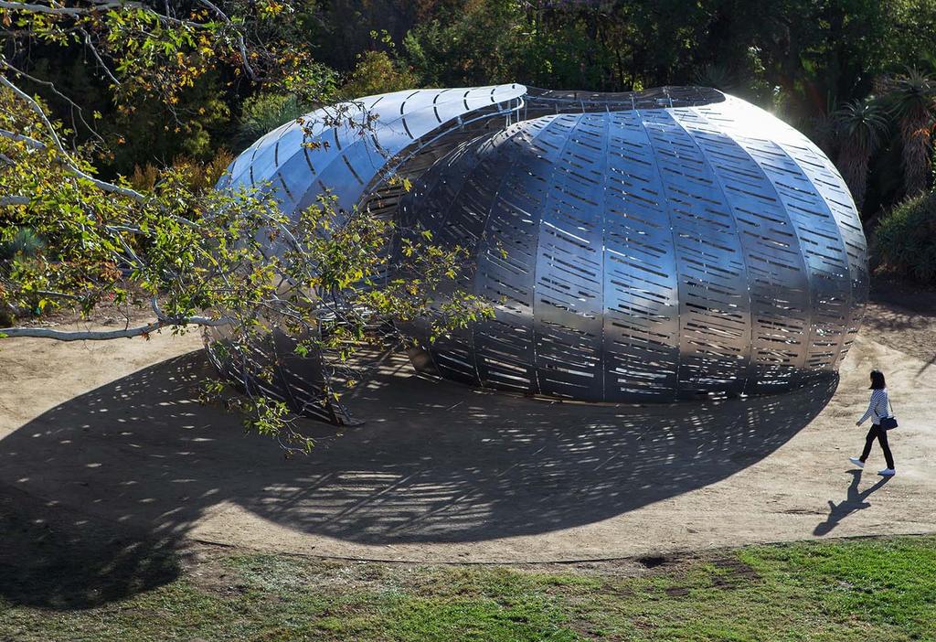
Do you remember putting a shell to your ear to listen to the ocean? What if you could walk into a shell and listen to the sounds of space?
|
|
|
- Erika McCarthy
- 5 years ago
- Views:
Transcription

1 Category: Small Project / Object Location: San Marino, CA Completed: 2016 SQ FT: 1100 Do you remember putting a shell to your ear to listen to the ocean? What if you could walk into a shell and listen to the sounds of space?
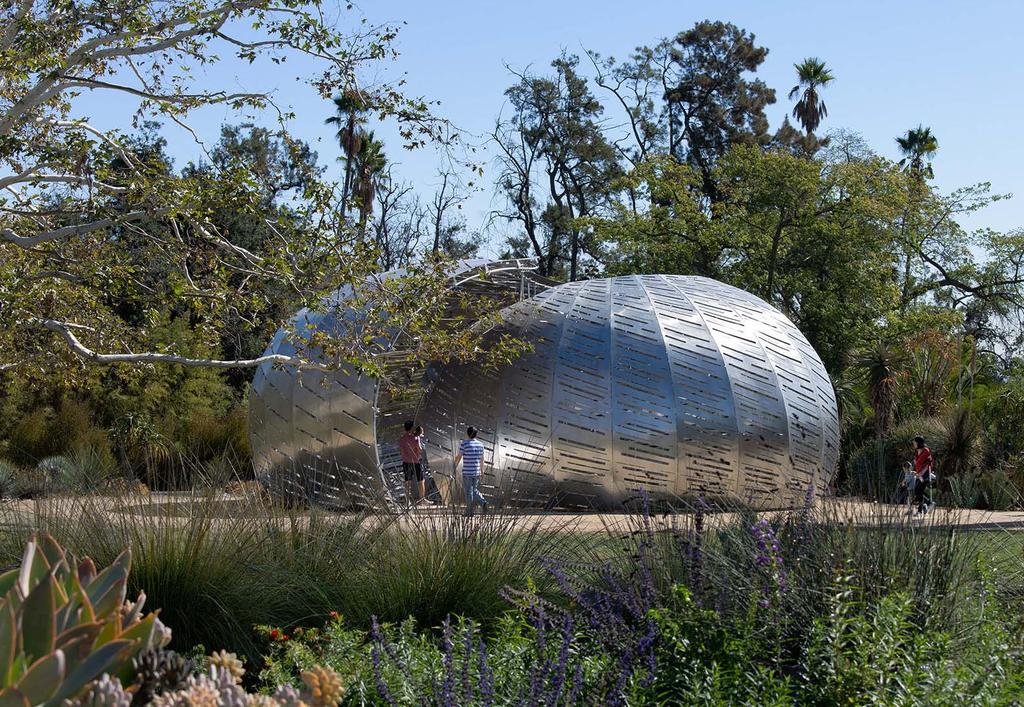
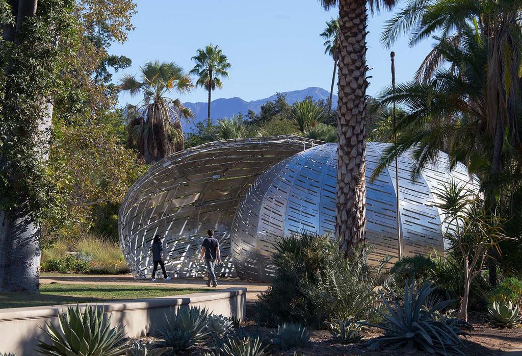
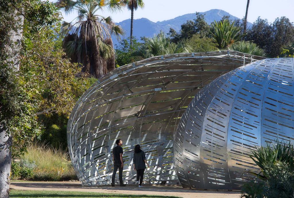
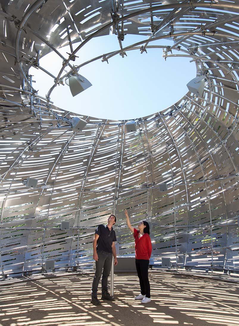
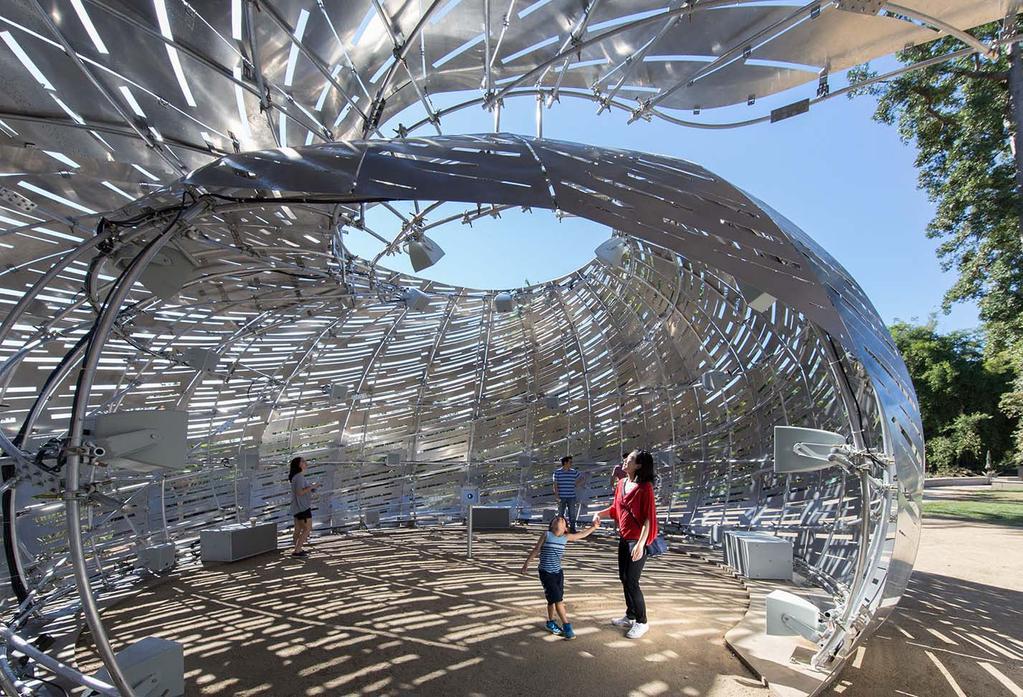
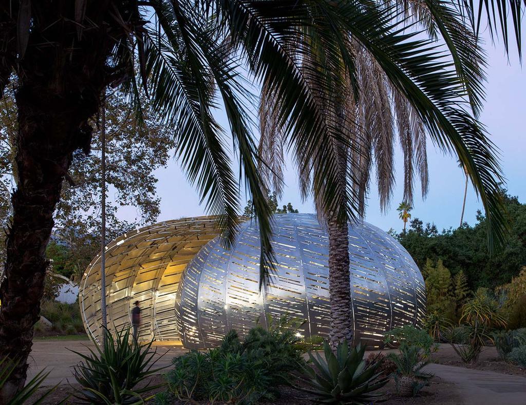
2 Project Narrative: Do you remember putting a shell up to your ear to listen to the ocean? What if you could walk into a shell and listen to the sounds of space- or rather, a symphony built out of the sounds of satellites in space? This was what we proposed when approached by NASA to design a traveling pavilion where the invisible sounds and trajectories of 19 NASA satellites orbiting and monitoring the Earth, could be experienced. Building on this childhood memory, a nautilus-shaped structure was created using 3,500 square feet of waterjet cut aluminum panels scribed with over 100 orbital paths fitted together and bolted to a curved framework of aluminum tubes. The shell defi nes a 30 diameter inner interior, open to the sky at its center. By employing an array of speakers within this space, programmed by a sound artist to map, translate, and then broadcast the sounds of these satellites, the team created a 3D sound chamber visitors can enter into and be immersed in the sounds of NASA s satellites as they fl y over, under and around them, in real time. The surface perforations echo the trajectories of the satellites high overhead, while mitigating exterior noise and decreasing wind loads on the relatively light structure. Using a simple set of connections, and numbered components that break down flat, the pavilion packs into a small cargo bin, and can be assembled or disassembled in 3 days on site. The Orbit Pavilion in the shape of a nautilus shell and filled with the sounds of satellites in space, has been a successful teaching tool, helping to spread the word about NASA s missions to understand the Earth. Visitors can enter into the shell, immerse themselves in the light and sounds of the inner chamber and experience the invisible trajectories of satellites (overhead but out of sight), leaving with a new awareness of the vastness of space, the complexity of the earth, and our place in it. Sustainability Objectives: In creating the pavilion, our goal was to use a material that was lightweight and compact to ship, but resilient enough to be reused multiple times, and in varying weather conditions. To that end, the panels and structure that make up the pavilion are made from aluminum that packs flat for shipping. All of the lengths of curved tube are less than 20 long, and nest into each other to make transportation easier and more cost effective. All of the connections are bolted and can be assembled and disassembled multiple times. Utilizing a light footing and stakes, we avoided the need for a larger, more substantial footing, minimizing the pavilon s impact on the site and the environment.
3 Performancy Data Worksheet - Project Category: Small Project / Object 1. Energy Efficiency Projects in California Projects Outside of California Modeled Performance for California Projects Energy Budget of Baseline Modeled Performance Of Percent Savings Beyond Bldg (Code Min) Your Design Code Minimum Year of Title 24 Standard kbtu/sf/yr kbtu/sf/year % N/A N/A N/A N/A Measured Performance for California Projects N/A Rated Performance - Low rise residential projects only N/A Modeled Performance for Non-California Projects Energy Budget of Baseline Bldg (Code Min) Modeled Performance Of Your Design Standard and Year of Standard kbtu/sf/yr kbtu/sf/year % N/A N/A N/A N/A Measured Performance N/A Rated Performance - Low rise residential projects only N/A Percent Savings Beyond Code Minimum 2. Renewable Energy & Net Energy Use Renewable Source Annual Renewable Energy Production Net Energy Consumption Modeled or Actual Data N/A N/A N/A N/A 3.Water Use & Reuse Water Efficient Fixture Selection Water Efficient Landscape Design On-Site Water Reuse Systems Total Annual Potable Water Savings Flow Rates: GPF/GPM % Saved & GPY % Saved & GPY % Saved & GPY N/A N/A N/A N/A 4. Material Use & Selection For Resource Efficiency & Health Structure Enclosure Finishes Reduction of toxics Promotion of product transparency Deconstruction methods Construction material recycling Y Y Y Y Y Y Y Y Y Y Y Y Y Y Y Y Y Y Y Y Y

 8. OSTM / JASON 2 15. EO-1 2. SMAP 9. Landsat 8 (USGS) 16. QuikSCAT 3. RapidSCAT (ISS) 10. CALIPSO 17. Aqua 4. CATS (ISS) 11. CloudSat 18.")
4 2PM Aluminum Shell Surface 72 water-jet cut aluminum panels tied together and bolted to the structural frame to create a double-curved shell. Structural Frame 1,300 linear feet of curved aluminum tubes connected together to create a structural spiral diagrid. 4PM 3D Sound Chamber 24 speaker array arranged within a 30 foot diameter inner chamber, allows visitors to have the sensation of standing in the orbital path of 1 of 19 NASA satellites as it orbits the Earth. 8AM 7PM NASA Satellite Paths 1. DSCOVR (NOAA) 8. OSTM / JASON EO-1 2. SMAP 9. Landsat 8 (USGS) 16. QuikSCAT 3. RapidSCAT (ISS) 10. CALIPSO 17. Aqua 4. CATS (ISS) 11. CloudSat 18. Terra 5. OCO Aura 19. Landsat7 6. Suomi NPP 13. SORCE (USGS) 7. GPM 14. GRACE (2) Footing 163 feet of CNC milled mirrored panels connected together to create a continous base for the pavilion. Axonometric Diagram


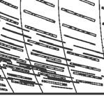

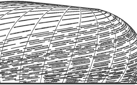
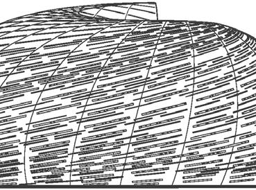
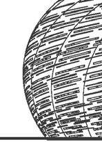
5 3,500 sf of aluminum becomes a perforated, curved nautilus shell West North South East Elevations
 10. CALIPSO 11. CloudSat 12. Aura 13. SORCE 14. GRACE (2) 15. EO-1 16. QuikSCAT 17. Aqua 18. Terra 19.")
6 A shell big enough to walk into and listen to SPACE (Listen to the sounds of satellites in space, in real time) NASA Satellites 1. DSCOVR (NOAA) 2. SMAP 3. RapidSCAT (ISS) 4. CATS (ISS) 5. OCO-2 6. Suomi NPP 7. GPM 8. OSTM / JASON 2 9. Landsat 8 (USGS) 10. CALIPSO 11. CloudSat 12. Aura 13. SORCE 14. GRACE (2) 15. EO QuikSCAT 17. Aqua 18. Terra 19. Landsat7 (USGS) 3D Sound Chamber The Orbit Pavilion uses satellite tracking data provided by NASA to determine the orbital location of each of it s 19 earth-focused satellites, in relation to the Pavilion s location on planet earth. This positional data is updated in real time. As a satellite orbits around the earth, the sound associated with it, seems to move through the Pavilion s inner chamber via the hemisphere of speakers positioned within the space, echoing the trajectory of the satellite 500 miles above in Earth s low orbit. Speaker Diagram
7 Made to travel, on site assembly takes 5 people, 3 days Aluminum Shell Surface ,500 sf of aluminum sheeting is water-jet cut and riveted together to created 28 panels. These panels are stitched together on site using removable ties and then bolted to the curved aluminum frame to create the double curved shell surface of the Pavilion. The surface perforations echo the orbital paths of the satellites, mitigate exterior noise and decrease wind loads on the relatively light structure Panelizaton Diagram
8
9
10
11

12
13


14 On site assembly in 3 days Diagrid Frame: 20 sections, numbered, clamp together on site Tabbed Connection: Panel to Panel, 1 per 18 Tabbed Connection (exterior condition) Waterjet, folded 90 deg. inward Panel (exterior condition) numbered, align on tabs North Elevation
15
Current and Upcoming NASA Hurricane Measurement Missions National Hurricane Conference
 NASA Science Mission Directorate Earth Science Division Applied Sciences Program Current and Upcoming NASA Hurricane Measurement Missions National Hurricane Conference April 18, 2017 Formulation Implementation
National Aeronautics and Space Administration. Earth Day is everyday at NASA. activity booklet
 National Aeronautics and Space Administration Earth Day is everyday at NASA activity booklet Earth Day is everyday at NASA NASA s Fleet of Earth Observing Satellites ACRIMSAT Landsat 7 Aqua SORCE Terra
Interpretation of Polar-orbiting Satellite Observations. Atmospheric Instrumentation
 Interpretation of Polar-orbiting Satellite Observations Outline Polar-Orbiting Observations: Review of Polar-Orbiting Satellite Systems Overview of Currently Active Satellites / Sensors Overview of Sensor
Earth Science Flight Mission Overview
 Earth Science Flight Mission Overview Nand Topiwala Science Mission Directorate NASA Headquarters April 25, 2007 Earth Science Missions Afternoon Constellation, or A-Train, Multi-Satellite Observatory
23 rd Annual CQSDI Gregory L. Robinson, Deputy Associate Administrator for Programs March 2016
 23 rd Annual CQSDI Gregory L. Robinson, Deputy Associate Administrator for Programs March 2016 Achieving Alignment for Pioneering Space HUMAN EXPLORATION & OPERATIONS (HEOMD) OFFICE OF COMMUNICATIONS SCIENCE
NASA Operating Missions
 NASA WGCV38 Update K. Thome Based on charts from M. Freilich, H. Maring, B. Markham, S. Volz Earth Science Division, Science Mission Directorate September 2014 NASA Operating Missions Feb. 2013 Feb. 2014
Proposal for Regent Street Public Art Project Ned Kahn, September 1, Salt/Lake
 Proposal for Regent Street Public Art Project Ned Kahn, September 1, 2015 Salt/Lake For the last 30 years, I have been creating large-scale public artworks that increase people s awareness of natural phenomena.
How does NASA study hurricanes? 17 August 2015, by Max Gleber
 How does NASA study hurricanes? 17 August 2015, by Max Gleber Hurricanes are the most powerful weather event on Earth. NASA's expertise in space and scientific exploration contributes to essential services
New NASA Ocean Observations and Coastal Applications
 New NASA Ocean Observations and Coastal Applications Duane Armstrong Chief, Applied Science & Technology Project Office August 20, 2014 1 Outline NASA s new Earth Science Ocean Science Missions for 2014
Your web browser (Safari 7) is out of date. For more security, comfort and the best experience on this site: Update your browser Ignore
 is out of date. For more security, comfort and the best experience on this site: Update your browser Ignore") Your web browser (Safari 7) is out of date. For more security, comfort and the best experience on this site: Update your browser Ignore ALTIMETER altitude meter For the complete encyclopedic entry with
Your web browser (Safari 7) is out of date. For more security, comfort and the best experience on this site: Update your browser Ignore ALTIMETER altitude meter For the complete encyclopedic entry with
REMOTE SENSING TEST!!
 REMOTE SENSING TEST!! This is a really ugly cover page I m sorry. Name. Score / 100 Directions: (idk if I need to put this???) You have 50 minutes to take this test. You may use a cheatsheet (2 pages),
Measuring Carbon Dioxide from the A-Train: The OCO-2 Mission
 Measuring Carbon Dioxide from the A-Train: The OCO-2 Mission David Crisp, OCO-2 Science Team Leader for the OCO-2 Science Team Jet Propulsion Laboratory, California Institute of Technology March 2013 Copyright
The Probabilistic Risk Assessment of the CloudSat Profiling Radar
 The Probabilistic Risk Assessment of the CloudSat Profiling Radar Todd Paulos, Alejo Engineering, Simi Valley, CA John Klohoker,,, Pasadena, CA May 2008 What is CloudSat? Launched on April 28, 2006 with
Lab 20. Predicting Hurricane Strength: How Can Someone Predict Changes in Hurricane Wind Speed Over Time?
 Predicting Hurricane Strength How Can Someone Predict Changes in Hurricane Wind Speed Over Time? Lab Handout Lab 20. Predicting Hurricane Strength: How Can Someone Predict Changes in Hurricane Wind Speed
NES: Weather and Climate: Satellite Meteorology
 LIVE INTERACTIVE LEARNING @ YOUR DESKTOP NES: Weather and Climate: Satellite Meteorology Presented by: Rudo Kashiri January 23, 2012 Weather and Climate: Satellite Meteorology Presented by Rudo Kashiri
Weather and Climate: Satellite Meteorology
 LIVE INTERACTIVE LEARNING @ YOUR DESKTOP Weather and Climate: Satellite Meteorology Presented by: Rudo Kashiri April 4, 2013 6:30 p.m. 8:00 p.m. Eastern time 1 2 http://learningcenter.nsta.org NSTA Learning
NASA WGCV37 Update. K. Thome Based on charts from M. Freilich and H. Maring Earth Science Division, Science Mission Directorate February 2014
 NASA WGCV37 Update K. Thome Based on charts from M. Freilich and H. Maring Earth Science Division, Science Mission Directorate February 2014 NASA On-Orbit Operating Flight Missions Missions Partnerships
The Orbiting Carbon Observatory (OCO)
") GEMS 2006 Assembly The Orbiting Carbon Observatory (OCO) http://oco.jpl.nasa.gov David Crisp, OCO PI (JPL/Caltech) February 2006 1 of 13, OCO Dec 2005 Page 1 The Orbiting Carbon Observatory (OCO) OCO will
GEMS 2006 Assembly The Orbiting Carbon Observatory (OCO) http://oco.jpl.nasa.gov David Crisp, OCO PI (JPL/Caltech) February 2006 1 of 13, OCO Dec 2005 Page 1 The Orbiting Carbon Observatory (OCO) OCO will
The Moon s relationship with Earth The formation of the Moon The surface of the Moon Phases of the Moon Travelling to the Moon
 The Moon The Moon s relationship with Earth The Moon orbits the Earth every 27.3 days. The tides on Earth are caused mostly by the gravitational pull of the Moon and the Sun. The Moon's gravitational pull
NASA Report on the Status of Current and Future Earth Satellite Systems
 NASA Report on the Status of Current and Future Earth Satellite Systems Presented to CGMS-46 Plenary Session, Agenda Item D.10 Presenter: Jack Kaye, NASA Headquarters Report prepared based on inputs from
A tribute to Eero Saarinen and the North Chirstian Church
 orphosis A tribute to Eero Saarinen and the North Chirstian Church ero mit chapel inspiration I have always remembered one night on my travels as a student when I sat in a mountain village in Sparta.
MAR 110 LECTURE #9 Earth s Heat Budget / Atmosphere Dynamics
 MAR 110: Lecture 9 Outline Heat Budget / Atmosphere Dynamics 1 MAR 110 LECTURE #9 Earth s Heat Budget / Atmosphere Dynamics External Energy Source-the Sun The portion of the sun s energy that is intercepted
IOAG Mission Model. Meeting: IOAG 21. Last Updated by IOAG Secretariat on Mar 3, 2018
 IOAG Mission Model Meeting: IOAG 21 Last Updated by IOAG Secretariat on Mar 3, 2018 1 Earth Missions (1) AGILE COSMO SkyMed #1 COSMO SkyMed #2 COSMO SkyMed #3 COSMO SkyMed #4 Extended ASI COSMO SkyMed
HOLT PHYSICS Test A Two-Dimensional Motion and Vectors
 Chapter 3 HOLT PHYSICS Test A Two-Dimensional Motion and Vectors MULTIPLE CHOICE On the line at the left of each statement, write the letter of the choice that best completes the statement or answers the
cheops Assemble your own planet watcher cheops Paper Model Scale 1:15
 cheops cheops Assemble your own planet watcher Paper Model Scale 1:15 About CHEOPS The CHaracterising ExOPlanet Satellite, or CHEOPS, is a space science mission dedicated to the study of known exoplanets
NASA REPORT ON THE STATUS OF CURRENT AND FUTURE SATELLITE SYSTEMS. Brian D. Killough NASA Langley Research Center, Hampton, Virginia
 12 June 2013 Prepared by Agenda Item: D.2.5 Discussed in Plenary REPORT ON THE STATUS OF CURRENT AND FUTURE SATELLITE SYSTEMS Brian D. Killough Langley Research Center, Hampton, Virginia Executive summary
2nd Grade. Earth and Moon Cycles. Slide 1 / 133 Slide 2 / 133. Slide 3 / 133. Slide 4 / 133. Slide 5 / 133. Slide 6 / 133.
 Slide 1 / 133 Slide 2 / 133 2nd Grade Changing of Earth 2015-11-23 www.njctl.org Slide 3 / 133 Slide 4 / 133 Table of Contents: Changing of Earth Earth and Moon Cycles Click on the topic to go to that
2017 Near Space Balloon Competition (NSBC) Proposal Submission Form
 Proposal Submission Form") The North Dakota Space Grant Consortium (NDSGC) and the University of North Dakota (UND) will be holding the sixth annual Near Space Balloon Competition in the fall of 2016. We invite all interested North
The North Dakota Space Grant Consortium (NDSGC) and the University of North Dakota (UND) will be holding the sixth annual Near Space Balloon Competition in the fall of 2016. We invite all interested North
Unlocking a New Era in Biodiversity Science Keck Institute for Space Studies, Pasadena, CA, October 1-5, Dreaming of 2026
 Unlocking a New Era in Biodiversity Science Keck Institute for Space Studies, Pasadena, CA, October 1-5, 2018 Dreaming of 2026 Woody Turner Earth Science Division NASA Headquarters October 2, 2018 (Pre)Formulation
Interannual variability of top-ofatmosphere. CERES instruments
 Interannual variability of top-ofatmosphere albedo observed by CERES instruments Seiji Kato NASA Langley Research Center Hampton, VA SORCE Science team meeting, Sedona, Arizona, Sep. 13-16, 2011 TOA irradiance
Orbit and Transmit Characteristics of the CloudSat Cloud Profiling Radar (CPR) JPL Document No. D-29695
 JPL Document No. D-29695") Orbit and Transmit Characteristics of the CloudSat Cloud Profiling Radar (CPR) JPL Document No. D-29695 Jet Propulsion Laboratory California Institute of Technology Pasadena, CA 91109 26 July 2004 Revised
Orbit and Transmit Characteristics of the CloudSat Cloud Profiling Radar (CPR) JPL Document No. D-29695 Jet Propulsion Laboratory California Institute of Technology Pasadena, CA 91109 26 July 2004 Revised
GPSRO and GNSS in the Context of NASA s Earth Science Program
 GPSRO and GNSS in the Context of NASA s Earth Science Program Dr. Jack Kaye* Associate Director for Research Earth Science Division Science Mission Directorate NASA Headquarters * This talk is prepared
Q25: Record the wavelength of each colored line according to the scale given.
 C. Measurement Errors and Uncertainties The term "error" signifies a deviation of the result from some "true" value. Often in science, we cannot know what the true value is, and we can only determine estimates
GRACE Cloudsat CALIPSO Aqua. Metop TRMM TOPEX. Meteor/ SAGE GIFTS NOAA/ POES. Landsat GOES MTSAT. SeaWiFS. Aura. Terra MSG. Jason ICESat SORCE
 TRMM Metop GRACE Cloudsat CALIPSO Aqua TOPEX Meteor/ SAGE GIFTS NOAA/ POES Landsat GOES SeaWiFS MTSAT Terra Aura Jason ICESat SORCE MSG THE EARTH SYSTEM SCIENCE It is the science that studies the whole
Exploring Geography. Chapter 1
 Exploring Geography Chapter 1 The Study of Geography Geography is the study of where people, places, and things are located and how they relate to each other. Greek meaning writing about or describing
2nd Grade Changing of Earth
 Slide 1 / 133 Slide 2 / 133 2nd Grade Changing of Earth 2015-11-23 www.njctl.org Slide 3 / 133 Table of Contents: Changing of Earth Earth and Moon Cycles Weather Cycles The Rock Cycle Defined Events Gradual
EARTH SCIENCE. Glen Phelan
 EARTH SCIENCE Glen Phelan WALCH EDUCATION The classroom teacher may reproduce materials in this book for classroom use only. The reproduction of any part for an entire school or school system is strictly
REMOTE SENSING KEY!!
 REMOTE SENSING KEY!! This is a really ugly cover page I m sorry. Name Key. Score / 100 Directions: You have 50 minutes to take this test. You may use a cheatsheet (2 pages), a non-graphing calculator,
Chapter 3 - RATE IN MECHANICAL SYSTEMS. Graphing Foldable /10
 1 NAME PERIOD Chapter 3 - RATE IN MECHANICAL SYSTEMS ACTIVITY LESSON DESCRIPTION SCORE/POINTS 1. NT FILL IN NOTE GUIDE SCORE /20 Graphing Foldable /10 2. TX PP. 122-135 WORKSHEET /53 3. MATH Math formula
Final Exam Review. Multiple Choice Identify the choice that best completes the statement or answers the question.
 ( Final Exam Review Multiple hoice Identify the choice that best completes the statement or answers the question. 1. is an isosceles triangle. is the longest side with length. = and =. Find. 4 x + 4 7
EARTH SCIENCE KEY UNIT 2-H
 EARTH SCIENCE KEY UNIT 2-H UNIT 2 MODELS & DIMENSIONS OF EARTH I. Model = ANYTHING THAT REPRESENTS THE PROPERTIES OF AN OBJECT OR SYSTEM A. Types and examples of models: 1. PHYSICAL Provides us with information
Talk Overview. Concepts. Climatology. Monitoring. Applications
 Atmospheric Rivers Talk Overview Concepts Climatology Monitoring Applications Satellite View Where is the storm? Where is the impact? Atmospheric Rivers Plume or fire hose of tropical moisture Heavy precipitation
Your Task: Read each slide then use the underlined red or underlined information to fill in your organizer.
 Severe Weather: Tornadoes and Hurricanes Thunderstorms and Lightning S6E4 d. Construct an explanation of the relationship between air pressure, weather fronts, and air masses and meteorological events
Maps and Globes. By Kennedy s Korner
 Maps and Globes By Kennedy s Korner Map Key or Symbols Maps use symbols to show places and things on Earth. Symbols are drawings that stand for something real. A map key tells you what each symbol stands
LAB 19. Lab 19. Differences in Regional Climate: Why Do Two Cities Located at the Same Latitude and Near a Body of Water Have Such Different Climates?
 Lab Handout Lab 19. Differences in Regional Climate: Why Do Two Cities Located at the Same Latitude and Near a Body of Water Have Such Different Climates? Introduction Weather describes the current atmospheric
POLAR WEEKEND SHRINKING ICE SHEETS AND RISING SEA LEVEL
 POLAR WEEKEND SHRINKING ICE SHEETS AND RISING SEA LEVEL TOPIC: Shrinking Ice Sheets and Rising Sea Levels PROJECT PERSONNEL: Dr. Robert Bindschadler, Glaciologist, NASA Scientists provide information on
Lab 21. Forecasting Extreme Weather: When and Under What Atmospheric Conditions Are Tornadoes Likely to Develop in the Oklahoma City Area?
 Forecasting Extreme Weather When and Under What Atmospheric Conditions Are Tornadoes Likely to Develop in the Oklahoma City Area? Lab Handout Lab 21. Forecasting Extreme Weather: When and Under What Atmospheric
2 Mapping Earth Reading Essentials. 2. Contrast What is the difference between a map view and a profile view?
 Mapping Earth Maps What do you think? Read the three statements below and decide whether you agree or disagree with them. Place an A in the Before column if you agree with the statement or a D if you disagree.
(What do you want to know)
") K (What do you know) W (What do you want to know) L (What have you learned) Flow of Energy Activity Sheet Purpose: Students will learn that there is more energy in warm/hot water than in cold water. This
K (What do you know) W (What do you want to know) L (What have you learned) Flow of Energy Activity Sheet Purpose: Students will learn that there is more energy in warm/hot water than in cold water. This
Introduction to Kinematics. Motion, Forces and Energy
 Introduction to Kinematics Motion, Forces and Energy Mechanics: The study of motion Kinematics The description of how things move 1-D and 2-D motion Dynamics The study of the forces that cause motion Newton
A Living Planet. The Earth Inside and Out
 A Living Planet The Earth Inside and Out Planet Earth Earth s Rotation, Revolution, and Tilt Most of Earth s energy comes from the Sun, which we call solar energy. Imagine that the Earth has an imaginary
How we made the maps. By Chris Walker. Map US Coast Survey
 How we made the maps By Chris Walker Map 1-1856 US Coast Survey Map 2-1856 US Coast Survey registered to Open Street Map, with landmark and historical resource boundaries. We started with a map that was
Community Involvement in Research Monitoring Pollinator Populations using Public Participation in Scientific Research
 Overview Community Involvement in Research Monitoring Pollinator Populations using Public Participation in Scientific Research Public Participation in Scientific Research (PPSR) is a concept adopted by
QuikSCAT High Precision Wind Speed Cross Sections
 QuikSCAT High Precision Wind Speed Cross Sections 2010-2017 Bryan Stiles, Alexander Fore, and Alexander Wineteer Jet Propulsion Laboratory, California Institute of Technology Ocean Vector Wind Science
The Future of NOAA Satellite Systems and Data
 The Future of NOAA Satellite Systems and Data -- H.R. 353 Weather Research & Forecasting Innovation Act of 2017 Committee on Earth Science & Applications from Space (CESAS) Washington, DC March 28, 2017
MAY 5, Noise Barrier Presentation SE Quadrant Noyes Street and Lincoln Street NOISE BARRIER ABUTTER MEETING. Tech Environmental, Inc.
 MAY 5, 2011 Noise Barrier Presentation SE Quadrant Noyes Street and Lincoln Street Jacobs Engineering Group Group Inc. Inc. 1 Introductions Agenda Overview of Interchange Project Overview of noise barrier
How Will Melting Ice Sheets Affect Us?
 PASSAGE 4 How Will Melting Ice Sheets Affect Us? Variation is normal. During the last ice age, for example, ice sheets also covered much of North America and Scandinavia. Why is what s happening now different
Bob Rettig Construction and Consulting
 1 Client: Sample A, Code Home: (714) 345-4265 Property: Main St. Anytown, Ca. 90000 Operator Info: Operator: JOE Estimator: 2 Company: Bob Rettig Construction Consulting Business: 30262 Crown Valley Parkway,
SMAP Winds. Hurricane Irma Sep 5, AMS 33rd Conference on Hurricanes and Tropical Meteorology Ponte Vedra, Florida, 4/16 4/20, 2018
 Intensity and Size of Strong Tropical Cyclones in 2017 from NASA's SMAP L-Band Radiometer Thomas Meissner, Lucrezia Ricciardulli, Frank Wentz, Remote Sensing Systems, Santa Rosa, USA Charles Sampson, Naval
3. This room is located in a building in New York State. On which side of the building is the window located? (1) north (3) east (2) south (4) west
 north (3) east (2) south (4) west") 1. The planetary winds in Earth s Northern Hemisphere generally curve to the right due to Earth s (1) orbit around the Sun (2) spin on its axis (3) magnetic field (4) force of gravity Base your answers
1. The planetary winds in Earth s Northern Hemisphere generally curve to the right due to Earth s (1) orbit around the Sun (2) spin on its axis (3) magnetic field (4) force of gravity Base your answers
Analysis of Change in Land Use around Future Core Transit Corridors: Austin, TX, Eric Porter May 3, 2012
 Analysis of Change in Land Use around Future Core Transit Corridors: Austin, TX, 1990-2006 PROBLEM DEFINITION Eric Porter May 3, 2012 This study examines the change in land use from 1990 to 2006 in the
Waves and Weather. 1. Where do waves come from? 2. What storms produce good surfing waves? 3. Where do these storms frequently form?
 Waves and Weather 1. Where do waves come from? 2. What storms produce good surfing waves? 3. Where do these storms frequently form? 4. Where are the good areas for receiving swells? Where do waves come
CHAPTER 2 SKILL SHEET 2: CELESTIAL NAVIGATION
 CHAPTER 2 SKILL SHEET 2: CELESTIAL NAVIGATION Before the invention of GPS technology, how were people on ships far at sea, out of the sight of land, able to tell where they were? For thousands of years
Name Earth Science Pd. Hurricanes. Directions: Read the information, view diagrams and answer the questions in the worksheet.
 Hurricanes Directions: Read the information, view diagrams and answer the questions in the worksheet. Hurricane Basics The ingredients for a hurricane include a pre-existing weather disturbance, warm tropical
F o l l o w i n g t h e F a l l i n g Meteorite
 Teachersʼ Guide F o l l o w i n g t h e F a l l i n g Meteorite Follow the falling Meteorite - Teachersʼ Guide - 2 Follow the Falling Meteorite Background Triangulation is a geometric technique for locating
World Space Week. Age 5-11 A FREE RESOURCE PACK FROM EDUCATIONCITY. Topical Teaching Resources. Suitability
 A FREE RESOURCE PACK FROM EDUCATIONCITY World Space Week Age 5-11 Topical Teaching Resources Suitability Free school resources by EducationCity. This may be reproduced for class use. World Space Week Topical
Galileo Telescope Solar Viewer Joseph Hora, Elizabeth Hora 2017/09/18
 Galileo Telescope Solar Viewer Joseph Hora, Elizabeth Hora 2017/09/18 17 7.75 5 2 1.5 3 2 1.5 Materials: (all dimensions in inches) 3x plywood sheet 17 x 7.75 x ½ 3x wood block cut from 2x4: 5 x 2 x 1.5
Chapter 22: Uses of Solar Energy
 Chapter 22: Uses of Solar Energy Goals of Period 22 Section 22.1: To describe three forms of energy derived from solar energy water power, wind power, and biomass Section 22.2: To illustrate some uses
Amita Mehta and Ana Prados
 Building Capacity in Utilizing NASA Remote Sensing Observations in SWAT for Water Resources and Agricultural Management Applications Amita Mehta and Ana Prados NASA - University of Maryland Baltimore County
ASTRONOMY. Chapter 24 BLACK HOLES AND CURVED SPACETIME PowerPoint Image Slideshow
 ASTRONOMY Chapter 24 BLACK HOLES AND CURVED SPACETIME PowerPoint Image Slideshow FIGURE 24.1 Stellar Mass Black Hole. On the left, a visible-light image shows a region of the sky in the constellation of
USA Space Debris Environment, Operations, and Policy Updates
 USA Space Debris Environment, Operations, and Policy Updates Presentation to the 48 th Session of the Scientific and Technical Subcommittee Committee on the Peaceful Uses of Outer Space United Nations
McKinley Presidential Library & Museum Planetarium Show Ohio Science Standards Fifth Grade
 Fifth Grade-Interconnections Within Systems: Cycles on, such as those occurring in ecosystems, in the solar system, and in the movement of light and sound result in describable patterns. Speed is a measurement
Chapter 2: 1-D Kinematics. Paul E. Tippens, Professor of Physics Southern Polytechnic State University Editing by Mr. Gehman
 Chapter 2: 1-D Kinematics Paul E. Tippens, Professor of Physics Southern Polytechnic State University Editing by Mr. Gehman 2007 The Cheetah: A cat that is built for speed. Its strength and agility allow
The Contribution of Locally Generated MTSat-1R Atmospheric Motion Vectors to Operational Meteorology in the Australian Region
 The Contribution of Locally Generated MTSat-1R Atmospheric Motion Vectors to Operational Meteorology in the Australian Region John Le Marshall Director, JCSDA 2004-2007 CAWCR 2007-2008 J. Le Marshall,
Relative and Absolute Directions
 Relative and Absolute Directions Purpose Learning about latitude and longitude Developing math skills Overview Students begin by asking the simple question: Where Am I? Then they learn about the magnetic
Kimberly J. Mueller Risk Management Solutions, Newark, CA. Dr. Auguste Boissonade Risk Management Solutions, Newark, CA
 1.3 The Utility of Surface Roughness Datasets in the Modeling of United States Hurricane Property Losses Kimberly J. Mueller Risk Management Solutions, Newark, CA Dr. Auguste Boissonade Risk Management
Lecture 4b: Meteorological Satellites and Instruments. Acknowledgement: Dr. S. Kidder at Colorado State Univ.
 Lecture 4b: Meteorological Satellites and Instruments Acknowledgement: Dr. S. Kidder at Colorado State Univ. US Geostationary satellites - GOES (Geostationary Operational Environmental Satellites) US
Moon. Grade Level: 1-3. pages 1 2 pages 3 4 pages 5 page 6 page 7 page 8 9
 Moon Grade Level: 1-3 Teacher Guidelines Instructional Pages Activity Page Practice Page Homework Page Answer Key pages 1 2 pages 3 4 pages 5 page 6 page 7 page 8 9 Classroom Procedure: Approximate Grade
NOAA S Arctic Program in 2017
 NOAA S Arctic Program in 2017 NOAA s Arctic Mission To determine how the Arctic system is changing on time scales of weeks to decades, particularly with respect to the consequences that the loss of sea
The Origin of Large and Small Science Satellites at NASA. Paul Hertz Chief Scientist, Science Mission Directorate, NASA August 2010
 The Origin of Large and Small Science Satellites at NASA Paul Hertz Chief Scientist, Science Mission Directorate, NASA August 2010 Overview NASA s Science Mission Directorate (SMD) is currently operating
Seismic Recording Station AZ_PFO Summary Report
 Seismic Recording Station AZ_PFO Summary Report Thank you for hosting station AZ_PFO on your property. We hope that you find the enclosed report interesting. Your station is one of the 2000 USArray seismic
Promoting Resilience to Changing Weather
 Promoting Resilience to Changing Weather Harpswell Neck Harpswell Sound Orr s Island Basin Cove Pott s Point Harpswell Conservation Commission March 30, 2017 What Does This Mean for Harpswell? Topography
Day 6: Angles of Depression and Elevation. Unit 5: Trigonometric Functions
 + Day 6: Angles of Depression and Elevation Unit 5: Trigonometric Functions Warm Up + n Find the missing side length 1) 2) n Find the missing angle 10 minutes 3) 4) End + Homework Check + Today s Objective
Lesson 3: Locating Plots on the Ground
 Review and Introduction Lesson 3: Locating Plots on the Ground So far, you have identified individual stands in the forest, learned about plot sampling, and marked locations on a map of where your inventory
Earth rotates on a tilted axis and orbits the Sun.
 Page of 7 KY CONCPT arth rotates on a tilted axis and orbits the Sun. BFOR, you learned Stars seem to rise, cross the sky, and set because arth turns The Sun is very large and far from arth arth orbits
GOES-16 & GOES-S: Natalia Donoho. Preparing Users for New Generation Satellites. WMO IPET-SUP-4 Geneva, Switzerland 26 February, 2018
 GOES-16 & GOES-S: Preparing Users for New Generation Satellites Natalia Donoho Satellite Products and Services Division (NOAA/NESDIS) WMO IPET-SUP-4 Geneva, Switzerland 26 February, 2018 GOES-R series
Introduction to Astronomy
 Introduction to Astronomy AST0111-3 (Astronomía) Semester 2014B Prof. Thomas H. Puzia Venus Venus The atmosphere of Venus is very dense and an opaque layer of clouds covers the planet, such that we cannot
Butte County Fire Department
 Butte County Fire Department Basic Land Navigation Verification Sheet I verify that Print Supervisor's name Print Employee's name has completed the Basic Land Navigation self study guide on Date Attached
MODULAR AND CUSTOM EXHIBIT SOLUTIONS
 2018 MODULAR AND CUSTOM EXHIBIT SOLUTIONS KLIK MAGNETIC DISPLAYS Crown Molding Finish off any pillow case box shape with our crown molding for a tight, architectural look. Artwork Framed artwork or just
NASA Earth Science Data Systems Program. Martha Maiden Program Executive, Earth Science Data Systems Earth Science Subcommittee November 28, 2012
 NASA Earth Science Data Systems Program Martha Maiden Program Executive, Earth Science Data Systems Earth Science Subcommittee November 28, 2012 NASA s Earth Observing System Data and Information System
U.S. Department of the Interior U.S. Geological Survey. Krista Karstensen Mark Drummond
 USGS Land-Cover Trends: A focus on contemporary land-use and land-cover change within the LCCs U.S. Department of the Interior U.S. Geological Survey Krista Karstensen Mark Drummond The Challenge Land
Butte County Fire Department
 Butte County Fire Department Basic Land Navigation Verification Sheet I verify that Print Supervisor s name has completed the Print Employee s name Basic Land Navigation self study guide on. Date Attached
Student Exploration: Hurricane Motion
 Name: Date: Student Exploration: Hurricane Motion Vocabulary: air pressure, Coriolis effect, eye, hurricane, knot, meteorologist, precipitation Prior Knowledge Questions (Do these BEFORE using the Gizmo.)
Directed Reading. Section: Viewing the Universe THE VALUE OF ASTRONOMY. Skills Worksheet. 1. How did observations of the sky help farmers in the past?
 Skills Worksheet Directed Reading Section: Viewing the Universe 1. How did observations of the sky help farmers in the past? 2. How did observations of the sky help sailors in the past? 3. What is the
SIMPLE LOW CONCENTRATING MODULE DESIGN INCRESES SOLAR CELL OUTPUT 25%
 SIMPLE LOW CONCENTRATING MODULE DESIGN INCRESES SOLAR CELL OUTPUT 25% Daniel Simon 3D Solar, Inc. 5555 N. Sheridan Rd. #1003 Chicago, IL 60640 e-mail: daniel@3dsolar.com ABSTRACT We present a simple low
By Helen and Mark Warner
 By Helen and Mark Warner Teaching Packs - Space - Page 1 In this section, you will learn about... 1. About the objects in the Solar System. 2. How the Solar System formed. 3. About the Asteroid Belt, Kuiper
Using Units of Measure
 Using Units of Measure Connections Have you ever... Calculated what time you would arrive somewhere? Converted temperatures from Fahrenheit to Celsius? Measured quantities for a recipe? Whenever you are
Learning Lab Seeing the World through Satellites Eyes
 Learning Lab Seeing the World through Satellites Eyes ESSENTIAL QUESTION What is a satellite? Lesson Overview: Engage students will share their prior knowledge about satellites and explore what satellites
Thunderstorms, Hurricanes, Tornados
 Thunderstorms, Hurricanes, Tornados Vocabulary Surface Winds typical west wind at this latitude prevailing wind from east below Florida's latitude high altitude, high speed river of air path of a storm
Thank you for your purchase!
 Thank you for your purchase! Please be sure to save a copy this document to your local computer. This activity is copyrighted by the AIMS Education Foundation. All rights reserved. No part of this work