Software Systems Adaptation by Composition. Lin Liu Information Systems Engineering Group, School of Software, Tsinghua University, China
|
|
|
- Roderick Perry
- 5 years ago
- Views:
Transcription

1 Software Systems Adaptation by Composition Lin Liu Information Systems Engineering Group, School of Software, Tsinghua University, China

2 Adaptive mechanism in natural world } Different chameleon species are able to vary their coloration and pattern through specialized cells contain pigments in three layers below their transparent outer skin. } Color change in chameleons has functions in social signaling and in reactions to temperature and other conditions, as well as in camouflage. } The relative importance of these functions varies with the circumstances, as well as the species.
3 Why Engineering Adaptive software? } Control the developmental process of software } Control the behavior of software } Control the quality of software I: Desired Satisfaction level of Goals Difference Calculator (Controller?) Heuristic rules, guidelines for improvement Adaptation Process Engine (Actuator?) O: Adaptation Action Execution Engine (System?) Current Satisfaction level of Goals Monitor / Evaluator (Sensors?) C: interactions with Feedback loop in goal-oriented RE (Liu, et al, IWSC, 2007) 3

4 A Typology of Systems with Goal Models with Yunsong Jian, Tong Li, Eric Yu
5 Static Systems Scenario } the system requirements remain unchanged at run-time. } It means that the system responds to the operating environment and users requests in a fixed and predefined way. } In the requirements model for static systems, the goal set G is fixed, goal refinement and operationalization is determined at design time. } Environment variables associated to the goal model take constant value.

![::={Rpulse[i],Gpulse[i]} b ::={Stop[i],Go[i]}](/docs-images/87/96066038/images/6-1.jpg "i::{left,right} (Jackson, 2001) Under Construction")
6 Traffic Light Control Example } static Lights Controller a Light Units b Lights Sequence a ::={Rpulse[i],Gpulse[i]} b ::={Stop[i],Go[i]} i::{left,right} (Jackson, 2001) Under Construction R G R G left right

7 Goal Model for the static Traffic Light System

![Stop[left],Stop[right] for 50 seconds; Stop[left],Go[right]](/docs-images/87/96066038/images/8-1.jpg "for 75seconds; Stop[left],Stop[right] for 50 seconds;")
![Go[left],Stop[right] for 150 seconds; Observe the](/docs-images/87/96066038/images/8-2.jpg "environment at deployment time, change the setting when")
8 Reconfigured One-way Traffic Light System Reconfigured Traffic light Under Construction R G R Left G Stop[left],Stop[right] for 50 seconds; Stop[left],Go[right] for 75seconds; Stop[left],Stop[right] for 50 seconds; Go[left],Stop[right] for 150 seconds; Observe the environment at deployment time, change the setting when necessary Right Tsinghua University

9 The Sensitive/Reactive Systems Scenario } the system does change its behavior at run-time and the system could respond to certain predefined operating environmental changes and users requests. } This kind of systems has some adaptation ability but the ability is limited by a set of predefined rules. } The adaptation is the result of nondeterministic goal refinements at design time. } The achievement of goals depends on the states of the run-time environmental variables. This is a vivid example of gradually adding uncertainty into requirements analysis and system development.
10 Sensitive One-way Traffic Light System a Light Units b Lights Controller Lights Sequence c Road Sensors d Vehicle Traffic e a ::={Rpulse[i],Gpulse[i]} d ::={VehiclePassSensor[i]} b ::={Stop[i],Go[i]} e ::={VehicleTraversing[v]} c ::={SensorOn[i]} i::{left,right} Under Construction Sensor Sensor R G R G left Tsinghua University right

11

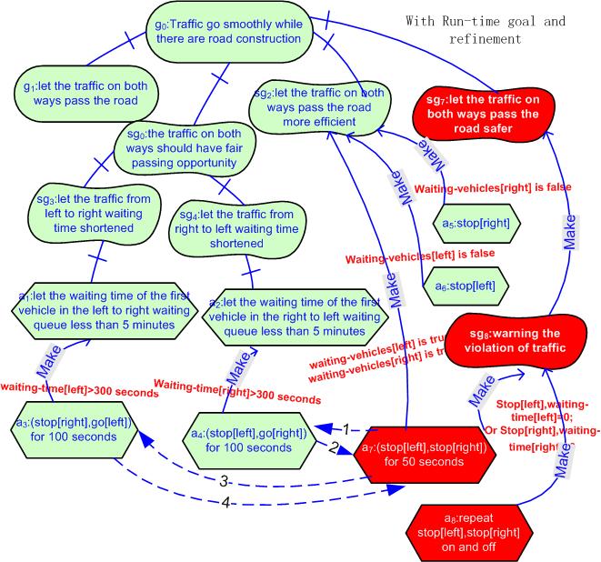
12 The Run-Time Adaptation Scenario } the system requirements changes and the system adaptation actions and the adaptation rules are not completely predefined, there is greater uncertainty at the design time. } At first the adaptation rules set R only contain some predefined rules. } When the system is running, in order to handle the changes of the operational environment and the users needs, new goals, new environment conditions, new activities and new rules are added to the sets G, E, A and R at run-time respectively.
13 Adaptive One-Way Traffic Light System } Under Construction Sensor Sensor R G R G left right Tsinghua University
14
15 Collaborative One-way Traffic Light System } Under Construction Sensor Sensor R G R G left right Tsinghua University

16
17
18 Collaboration } The software collaboration means that the software entities are being aware of the existence of others, and could collaborate to achieve a common goal. } There are delegation and informing activities between them. } The states of other components are partially observable by other components, as environment variables. } An abstract collaboration model for components has associated goal-action refinement structures, interconnected, and maintained through protocols supporting the requesting, publication, searching, binding, delegation and revoking relationships among individual components.
19 Adaptive Design in Response to Changing Requirements } Systems as organisations } Framework that facilitates the development of adaptive rolebased system structure, with role-role contracts } Contracts define (rich) interaction protocols and measure performance implemented with association aspects } Strict separation of role from player roles define the function, players do the work: role-player bindings } A role is stateful and is defined as a set of provided/ required service interfaces } Organisation (system) is a recursive hierarchy of selfmanaged composites, with each having an organiser role } Roles can be filled by players of different capabilities } Services, Objects, Self-managed composites, Agents, Humans
20 Summary } Composition-based development of software systems from a set of software components distributed over the Internet. } ideally, the software components, are autonomous, self-contained and distributed. } It is able to respond to the perceived changes in the environment by means of reconfiguration and reorganization } It collaborates with one another on demand, which adopts an iterative composition process turning various disordered resources into an ordered software system. } brings promptness, flexibility and reusability in building distributed software systems. } As a new requirement emerges, or a new software technology becomes available, or an unexpected change happens, existing requirements-solutions bindings can be adjusted for optimization purpose.

21 An Analogue:Software vs. Data } Software are like the pipes and pumps and storage tanks in a plumbing system } Data is like the water flowing through those pipes } And there is also data about the requirements, design and run-time status of the software } If you suspected that your water was poisoned, Would you call the plumber? What if you saw water leaking, or reduction of water volume,?

22 Call for Papers and Panel Proposals 11th International Workshop on Software Cybernetics IWSC 2014 In conjunction with COMPSAC 2014, July 21-25, 2014 Vasteras, Sweden, July 21, 2014 Thanks!
Copernicus Big Data Workshop, Brussels, Belgium
 Copernicus Big Data Workshop, Brussels, Belgium 13 th March 2014 Bart De Lathouwer 2013 Open Geospatial Consortium Agenda Geospatial Big Data Open Geospatial Consortium s and Big Data Conclusions 2014
DECISION SUPPORT SYSTEMS FOR PARTICIPATORY FLOOD RISK AND DISASTER MANAGEMENT
 DECISION SUPPORT SYSTEMS FOR PARTICIPATORY FLOOD RISK AND DISASTER MANAGEMENT PhD Thesis Panayiotis Sophronides, Dipl.-Ing., MSc & DIC, PhD Candidate Advisory committee: Prof. Maria Giaoutzi (Supervisor),
Multi agent Evacuation Simulation Data Model for Disaster Management Context
 Multi agent Evacuation Simulation Data Model for Disaster Management Context Mohamed Bakillah, Alexander Zipf, J. Andrés Domínguez, Steve H. L. Liang GI4DM 2012 1 Content Context Requirements for Enhanced
Research on the Architecture of Urban Emergency System Based on GIS Zhe Li1,a, Xiang Teng2,b
 3rd International Conference on Materials Engineering, Manufacturing Technology and Control (ICMEMTC 2016) Research on the Architecture of Urban Emergency System Based on GIS Zhe Li1,a, Xiang Teng2,b 1
Ontology Summit Framing the Conversation: Ontologies within Semantic Interoperability Ecosystems
 Ontology Summit 2016 Framing the Conversation: Ontologies within Semantic Interoperability Ecosystems GeoSciences Track: Semantic Interoperability in the GeoSciences Gary Berg-Cross and Ken Baclawski Co-Champions
An object-oriented design process. Weather system description. Layered architecture. Process stages. System context and models of use
 An object-oriented design process Process stages Structured design processes involve developing a number of different system models. They require a lot of effort for development and maintenance of these
Engineering Self-Organization and Emergence: issues and directions
 5/0/ Engineering Self-Organization and Emergence: issues and directions Franco Zambonelli franco.zambonelli@unimore.it Agents and Pervasive Computing Group Università di Modena e Reggio Emilia SOAS 005
The Swedish National Geodata Strategy and the Geodata Project
 The Swedish National Geodata Strategy and the Geodata Project Ewa Rannestig, Head of NSDI Co-ordination Unit, Lantmäteriet, ewa.rannstig@lm.se Ulf Sandgren, Project Manager Geodata Project, Lantmäteriet,
Optimum Repartition of Transport Capacities in the Logistic System using Dynamic Programming
 Theoretical and Applied Economics Volume XVIII (011), No. 8(561), pp. 17-0 Optimum Repartition of Transport Capacities in the Logistic System using Dynamic Programming Gheorghe BĂŞANU Bucharest Academy
Changes in the Spatial Distribution of Mobile Source Emissions due to the Interactions between Land-use and Regional Transportation Systems
 Changes in the Spatial Distribution of Mobile Source Emissions due to the Interactions between Land-use and Regional Transportation Systems A Framework for Analysis Urban Transportation Center University
Object Modeling Approach! Object Modeling Approach!
 Object Modeling Approach! 1 Object Modeling Approach! Start with a problem statement! High-level requirements! Define object model! Identify objects and classes! Prepare data dictionary! Identify associations
GOVERNMENT GIS BUILDING BASED ON THE THEORY OF INFORMATION ARCHITECTURE
 GOVERNMENT GIS BUILDING BASED ON THE THEORY OF INFORMATION ARCHITECTURE Abstract SHI Lihong 1 LI Haiyong 1,2 LIU Jiping 1 LI Bin 1 1 Chinese Academy Surveying and Mapping, Beijing, China, 100039 2 Liaoning
A Price-Based Approach for Controlling Networked Distributed Energy Resources
 A Price-Based Approach for Controlling Networked Distributed Energy Resources Alejandro D. Domínguez-García (joint work with Bahman Gharesifard and Tamer Başar) Coordinated Science Laboratory Department
Global Workspace Theory Inspired Architecture for Autonomous Structural Health Monitoring
 Global Workspace Theory Inspired Architecture for Autonomous Structural Health Monitoring 31 July 12 A Framework for Incorporating Contextual Information to Improve Decision Making Multifunctional Materials
Spatially Enabled Society
 International Seminar on Land Administration Trends and Issues in Asia and the Pacific Region Spatially Enabled Society Abbas Rajabifard Vice Chair PCGIAP-WG3 Vice-President (President Elect), GSDI Association
THE DESIGN AND IMPLEMENTATION OF A WEB SERVICES-BASED APPLICATION FRAMEWORK FOR SEA SURFACE TEMPERATURE INFORMATION
 THE DESIGN AND IMPLEMENTATION OF A WEB SERVICES-BASED APPLICATION FRAMEWORK FOR SEA SURFACE TEMPERATURE INFORMATION HE Ya-wen a,b,c, SU Fen-zhen a, DU Yun-yan a, Xiao Ru-lin a,c, Sun Xiaodan d a. Institute
Testing of Geoportals: INSPIRE demands and challenges
 Testing of Geoportals: INSPIRE demands and challenges Imad Abugessaisa & Solgerd Tanzilli Lantmäteriet - Swedish Mapping, Cadastre and Land Registration Authority / Future Position X, Gävle INSPIRE 2010
ITIL and DevOps Kaimar Karu Head of Product Strategy and Development, AXELOS
 ITIL and DevOps Kaimar Karu Head of Product Strategy and Development, AXELOS THE CHALLENGE P R O C E S S M A N A G E M E N T C O M M O N A N T I - PAT T E R N S» By-the-book ITIL implementations» Ideal
EXPECTATIONS OF TURKISH ENVIRONMENTAL SECTOR FROM INSPIRE
 EXPECTATIONS OF TURKISH ENVIRONMENTAL SECTOR FROM INSPIRE June, 2010 Ahmet ÇİVİ Tuncay DEMİR INSPIRE in the Eyes of MoEF Handling of Geodata by MoEF Benefits Expected TEIEN First Steps for INSPIRE Final
SWEDISH SDI DEVELOPMENT & IMPLEMENTATION OF INSPIRE
 SWEDISH SDI DEVELOPMENT & IMPLEMENTATION OF INSPIRE Christina Wasström, Lantmäteriet, 801 82 Gävle, Sweden, christina.wasstrom@lm.se ABSTRACT The Swedish Government and Parliament has given Lantmäteriet
Development of the system for automatic map generalization based on constraints
 Development of the system for automatic map generalization based on constraints 3rd Croatian NSDI and INSPIRE Day and 7th Conference Cartography and Geoinformation Marijan Grgić, mag. ing. Prof. dr. sc.
Transactions on Information and Communications Technologies vol 18, 1998 WIT Press, ISSN
 GIS in the process of road design N.C. Babic, D. Rebolj & L. Hanzic Civil Engineering Informatics Center, University ofmaribor, Faculty of Civil Engineering, Smetanova 17, 2000 Maribor, Slovenia. E-mail:
Traffic Simulation Toolbox User s Manual
 User s Manual Jesse Haber-Kucharsky Shreyas Sundaram University of Waterloo Department of Electrical and Computer Engineering May 31, 2011 Contents 1 Introduction 1 2 Basic Use 2 2.1 Quick-Start Example.......................
Performance Evaluation of Anti-Collision Algorithms for RFID System with Different Delay Requirements
 Performance Evaluation of Anti-Collision Algorithms for RFID System with Different Delay Requirements Warakorn Srichavengsup Computer Engineering, Robotics and Technology Laboratory Faculty of Engineering,
Modeling Smart Growth in the Southeast Using Smart-SLEUTH. November 20, 2014 SOUTH ATLANTIC LCC WEB FORUM Monica A. Dorning
 Modeling Smart Growth in the Southeast Using Smart-SLEUTH November 20, 2014 SOUTH ATLANTIC LCC WEB FORUM Monica A. Dorning (Sub)Urbanization in the Southeast November 20, 2014 SOUTH ATLANTIC LCC WEB FORUM
SPIMA Spatial dynamics and strategic planning in metropolitan areas
 Targeted Analysis SPIMA Spatial dynamics and strategic planning in metropolitan areas Executive Summary Conference version 1 February 2018 0 1. Background To address the challenges of metropolitan development
Western States Rural Transportation Consortium Meeting. June 14, 2011
 Western States Rural Transportation Consortium Meeting June 14, 2011 1 Overview/Agenda Welcome / Introductions / Recent ITS Activities General Status of the WSRTC Clarus One Stop Shop Update Year 1 Incubator
Components for Accurate Forecasting & Continuous Forecast Improvement
 Components for Accurate Forecasting & Continuous Forecast Improvement An ISIS Solutions White Paper November 2009 Page 1 Achieving forecast accuracy for business applications one year in advance requires
GEOGRAPHIC INFORMATION SYSTEMS Session 8
 GEOGRAPHIC INFORMATION SYSTEMS Session 8 Introduction Geography underpins all activities associated with a census Census geography is essential to plan and manage fieldwork as well as to report results
Overview of Control System Design
 Overview of Control System Design General Requirements 1. Safety. It is imperative that industrial plants operate safely so as to promote the well-being of people and equipment within the plant and in
The purpose of this report is to recommend a Geographic Information System (GIS) Strategy for the Town of Richmond Hill.
 Strategy for the Town of Richmond Hill.") Staff Report for Committee of the Whole Meeting Department: Division: Subject: Office of the Chief Administrative Officer Strategic Initiatives SRCAO.18.12 GIS Strategy Purpose: The purpose of this report
Staff Report for Committee of the Whole Meeting Department: Division: Subject: Office of the Chief Administrative Officer Strategic Initiatives SRCAO.18.12 GIS Strategy Purpose: The purpose of this report
US National Spatial Data Infrastructure A Spatial Framework for Governance and Policy Development to Enable a Location-Based Digital Ecosystem
 GeoPlatform Workshop 7 Dec 2016, Department of the Interior Washington, D.C. US National Spatial Infrastructure A Spatial Framework for Governance and Policy Development to Enable a Location-Based Digital
The Inter-Agency Space Debris Coordination Committee (IADC)
") The Inter-Agency Space Debris Coordination Committee (IADC) An overview of the IADC annual activities Holger Krag, ESA IADC Chair www.iadc-online.org 54 th Session of the Scientific and Technical Subcommittee
The Inter-Agency Space Debris Coordination Committee (IADC) An overview of the IADC annual activities Holger Krag, ESA IADC Chair www.iadc-online.org 54 th Session of the Scientific and Technical Subcommittee
Urban Geo-Informatics John W Z Shi
 Urban Geo-Informatics John W Z Shi Urban Geo-Informatics studies the regularity, structure, behavior and interaction of natural and artificial systems in the urban context, aiming at improving the living
Background Document: Report of the Regional Committee of United Nations Global Geospatial Information Management for Asia and the Pacific
 Background Document: Report of the Regional Committee of United Nations Global Geospatial Information Management for Asia and the Pacific 1. Summary 1. This report highlights the activities carried out
GLOBAL SPATIAL DATA INFRASTRUCTURES and. International Cartographic Association.
 FIG-InterGeo, 11 October 2006 Munich, Germany GLOBAL SPATIAL DATA INFRASTRUCTURES and International Cartographic Association Milan KONECNY President; International Cartographic Association(ICA) Vice-President;
Space research. Horizon Work Programme. "Countdown to Horizon 2020 Space" Earth Observation topics. Brussels, 12 December 2013
 Space research Horizon 2020 - Work Programme "Countdown to Horizon 2020 Space" Earth Observation topics Brussels, 12 December 2013 richard.gilmore@ec.europa.eu Table of contents FP/Copernicus - general
Real-Time Scheduling and Resource Management
 ARTIST2 Summer School 2008 in Europe Autrans (near Grenoble), France September 8-12, 2008 Real-Time Scheduling and Resource Management Lecturer: Giorgio Buttazzo Full Professor Scuola Superiore Sant Anna
UML. Design Principles.
 .. Babes-Bolyai University arthur@cs.ubbcluj.ro November 20, 2018 Overview 1 2 3 Diagrams Unified Modeling Language () - a standardized general-purpose modeling language in the field of object-oriented
Kansas Next Generation 911 Data Remediation Program. Esri Imagery Forum June 26, 2016
 Kansas Next Generation 911 Data Remediation Program Esri Imagery Forum June 26, 2016 Kansas NextGen 911 Project Overview Development of statewide Emergency Services IP Network (ESINet) GIS database development,
Ocean model, Interconnections within the climate model
 Ocean model, Interconnections within the climate model Vladimir Djurdjevic and Bora Rajkovic EXPERT WORKSHOP SEE RESEARCH FRAMEWORK IN REGIONAL CLIMATE MODELING FOR 2012-2017 Belgrade, Serbia, April 11-13,
Creation of an Internet Based Indiana Water Quality Atlas (IWQA)
") Department of Environmental Management Creation of an Internet Based Water Quality Atlas (IWQA) May 4, 2005 IUPUI 1200 Waterway Blvd., Suite 100 polis, 46202-5140 Water Quality Atlas John Buechler, Neil
Department of Environmental Management Creation of an Internet Based Water Quality Atlas (IWQA) May 4, 2005 IUPUI 1200 Waterway Blvd., Suite 100 polis, 46202-5140 Water Quality Atlas John Buechler, Neil
Response of the London Volcanic Ash Advisory Centre to the Eyjafjallajökull Eruption
 Paper 1B.3 Response of the London Volcanic Ash Advisory Centre to the Eyjafjallajökull Eruption Ian Lisk, Volcanic Ash Programme Manager, Met Office, UK 1. INTRODUCTION The Met Office is home to the London
Formalization of Self-Organizing Multi- Agent Systems with Event-B and Design Patterns (Tool usage)
") Formalization of Self-Organizing Multi- Agent Systems with Event-B and Design Patterns (Tool usage) Zeineb GRAJA zeineb.graja@irit.fr Frédéric MIGEON, Christine MAUREL, Marie-Pierre GLEIZES, Ahmed HADJ
Formalization of Self-Organizing Multi- Agent Systems with Event-B and Design Patterns (Tool usage) Zeineb GRAJA zeineb.graja@irit.fr Frédéric MIGEON, Christine MAUREL, Marie-Pierre GLEIZES, Ahmed HADJ
Planning in a Geospatially Enabled Society. Michael F. Goodchild University of California Santa Barbara
 Planning in a Geospatially Enabled Society Michael F. Goodchild University of California Santa Barbara What is a geospatially enabled society? Knowing the locations of all points of interest and their
BOXA-II ON-STREAM X-RAY FLUORESCENCE ANALYZER. Technical Description Version 2 BGRIMM AUTOMATION
 BOXA-II ON-STREAM X-RAY FLUORESCENCE ANALYZER Technical Description Version 2 BGRIMM AUTOMATION, South 4th Ring Road West, Beijing, China TEL: +86(10)59069762 Fax: +86(10)68360101 Contents BGRIMM AUTOMATION
Crowd Behavior Modeling in COMBAT XXI
 Crowd Behavior Modeling in COMBAT XXI Imre Balogh MOVES Research Associate Professor ilbalogh@nps.edu July 2010 831-656-7582 http://movesinstitute.org Report Documentation Page Form Approved OMB No. 0704-0188
TXWARN Tabletop Exercise: Hurricane Helen
 TXWARN Tabletop Exercise: Hurricane Helen July 31, 2015 Administrative Details In-studio participants and remote participants Situation manual Evaluations Training hours 1 In Studio: Welcome and Introductions
GIS Based Transit Information System for Metropolitan Cities in India
 PAPER REFERENCE NO.: PN-250 GIS Based Transit Information System for Metropolitan Cities in India Pal, Sarvjeet. a and Singh, Varun. b a M. Tech. (GIS & Remote Sensing); GIS Cell; Motilal Nehru National
EBS IT Meeting July 2016
 EBS IT Meeting 18 19 July 2016 Conference Call Details Conference call: UK Numbers Tel: 0808 238 9819 or Tel: 0207 950 1251 Participant code: 4834 7876... Join online meeting https://meet.nationalgrid.com/antonio.delcastillozas/hq507d31
MULTI-AGENT TRACKING OF A HIGH-DIMENSIONAL ACTIVE LEADER WITH SWITCHING TOPOLOGY
 Jrl Syst Sci & Complexity (2009) 22: 722 731 MULTI-AGENT TRACKING OF A HIGH-DIMENSIONAL ACTIVE LEADER WITH SWITCHING TOPOLOGY Yiguang HONG Xiaoli WANG Received: 11 May 2009 / Revised: 16 June 2009 c 2009
A REPRESENTATIONAL FRAMEWORK FOR BUILDING SYSTEMS CONTROL. Carnegie Mellon University, Pittsburgh PA USA
 Eighth International IBPSA Conference Eindhoven, Netherlands August -4, 23 A REPRESENTATIONAL FRAMEWORK FOR BUILDING SYSTEMS CONTROL Kristie Bosko Mertz and Ardeshir Mahdavi 2 Center for Building Performance
MOST control systems are designed under the assumption
 2076 IEEE TRANSACTIONS ON AUTOMATIC CONTROL, VOL. 53, NO. 9, OCTOBER 2008 Lyapunov-Based Model Predictive Control of Nonlinear Systems Subject to Data Losses David Muñoz de la Peña and Panagiotis D. Christofides
Roundabout Level of Service
 Roundabout Level of Service Rahmi Akçelik Director Akcelik & Associates Pty Ltd email: rahmi.akcelik@sidrasolutions.com web: www.sidrasolutions.com 8 January 2009 Contents 1. Introduction... 1 2. Fundamental
Mitigation planning in Epirus- The case of frost and snowfalls. Thematic seminar Epirus September 2011
 Mitigation planning in Epirus- The case of frost and snowfalls Thematic seminar Epirus September 2011 1 Structure of Mitigation Planning in Greece First Level: General Plan for Civil Protection Ksenokratis
2007 IEEE. Personal use of this material is permitted. However, permission to reprint/republish this material for advertising or promotional purposes
 2007 IEEE. Personal use of this material is permitted. However, permission to reprint/republish this material for advertising or promotional purposes or for creating new collective works for resale or
Interactive Visualization Tool (InViTo)
") Interactive Visualization Tool (InViTo) Stefano Pensa To cite this report: Stefano Pensa (2012) Interactive Visualization Tool (InViTo), in Angela Hull, Cecília Silva and Luca Bertolini (Eds.) Accessibility
Interactive Visualization Tool (InViTo) Stefano Pensa To cite this report: Stefano Pensa (2012) Interactive Visualization Tool (InViTo), in Angela Hull, Cecília Silva and Luca Bertolini (Eds.) Accessibility
The Inter-Agency Space Debris Coordination Committee (IADC)
") The Inter-Agency Space Debris Coordination Committee (IADC) An overview of IADC s annual activities Mitsuru Ohnishi, JAXA, Japan IADC Chair www.iadc-online.org 55 th Session of the Scientific and Technical
The Inter-Agency Space Debris Coordination Committee (IADC) An overview of IADC s annual activities Mitsuru Ohnishi, JAXA, Japan IADC Chair www.iadc-online.org 55 th Session of the Scientific and Technical
AIBO experiences change of surface incline.
 NW Computational Intelligence Laboratory AIBO experiences change of surface incline. Decisions based only on kinesthetic experience vector ICNC 07, China 8/27/07 # 51 NW Computational Intelligence Laboratory
Educational Objectives
 MDSS and Anti-Icing: How to Anti-Ice with Confidence Wilf Nixon, Ph.D., P.E. IIHR Hydroscience and Engineering University of Iowa Iowa City And Asset Insight Technologies, LLC Educational Objectives At
GeoWorlds: Integrated Digital Libraries and Geographic Information Systems
 GeoWorlds: Integrated Digital Libraries and Geographic Information Systems http://www.isi.edu/geoworlds Robert Neches In-Young Ko, Robert MacGregor, Ke-Thia Yao Distributed Scalable Systems Division USC
Modeling disruption and dynamic response of water networks. Sifat Ferdousi August 19, 2016
 Modeling disruption and dynamic response of water networks Sifat Ferdousi August 19, 2016 Threat to water networks The main threats to water infrastructure systems can be classified in three different
University of Lusaka
 University of Lusaka BSPH 315 Health Mapping & GIS Topic: Background of GIS Content: 1. Aim of the course 2. What do you know about GIS? 3. Difference between geographic data and geographic information
Physics-Aware Informative Coverage Planning for Autonomous Vehicles
 Physics-Aware Informative Coverage Planning for Autonomous Vehicles Michael J. Kuhlman 1, Student Member, IEEE, Petr Švec2, Member, IEEE, Krishnanand N. Kaipa 2, Member, IEEE, Donald Sofge 3, Member, IEEE,
Introduction to the Geographical Sciences Committee. AAG Annual Meeting April 2017
 Introduction to the Geographical Sciences Committee AAG Annual Meeting April 2017 The National Academies of Sciences, Engineering, and Medicine Inform decision making and public policy Provide independent
Lecture 7 Synthesis of Reactive Control Protocols
 Lecture 7 Synthesis of Reactive Control Protocols Richard M. Murray Nok Wongpiromsarn Ufuk Topcu California Institute of Technology AFRL, 25 April 2012 Outline Review: networked control systems and cooperative
A Model of GIS Interoperability Based on JavaRMI
 A Model of GIS Interoperability Based on Java Gao Gang-yi 1 Chen Hai-bo 2 1 Zhejiang University of Finance & Economics, Hangzhou 310018, China 2 College of Computer Science and Technology, Zhejiang UniversityHangzhou
Complexity Metrics. ICRAT Tutorial on Airborne self separation in air transportation Budapest, Hungary June 1, 2010.
 Complexity Metrics ICRAT Tutorial on Airborne self separation in air transportation Budapest, Hungary June 1, 2010 Outline Introduction and motivation The notion of air traffic complexity Relevant characteristics
We provide two sections from the book (in preparation) Intelligent and Autonomous Road Vehicles, by Ozguner, Acarman and Redmill.
 Intelligent and Autonomous Road Vehicles, by Ozguner, Acarman and Redmill.") We provide two sections from the book (in preparation) Intelligent and Autonomous Road Vehicles, by Ozguner, Acarman and Redmill. 2.3.2. Steering control using point mass model: Open loop commands We consider
We provide two sections from the book (in preparation) Intelligent and Autonomous Road Vehicles, by Ozguner, Acarman and Redmill. 2.3.2. Steering control using point mass model: Open loop commands We consider
Comprehensive Winter Maintenance Management System BORRMA-web MDSS inside to increase Road Safety and Traffic Flow
 Thorsten Cypra 1 Comprehensive Winter Maintenance Management System BORRMA-web MDSS inside to increase Road Safety and Traffic Flow American Public Works Association (APWA) Monday, 04/14/2008 3:30 4:30
Smart Cities and Urban Governance. The urbanapi Project: Bologna Case Study David C. Ludlow, Maria Paola Mauri, Chiara Caranti
 1 ABSTRACT Smart Cities and Urban Governance. The urbanapi Project: Bologna Case Study David C. Ludlow, Maria Paola Mauri, Chiara Caranti (David C. Ludlow, UWE University of the West of England, Bristol-
Entropy and Self Organizing in Edge Organizations
 Entropy and Self Organizing in Edge Organizations Yan Jin and Qianyu Liu Dept of Aerospace & Mechanical Engineering University of Southern California 14 th ICCRTS, June 15 17, 2009 Washington D.C. Background
The Next Generation of Traffic Management Systems
 AASHTO CTSO ITS Working Group Meeting The Next Generation of Traffic Management Systems What Resources Do Agencies Need & Is There Interest to Collaborate With TRB Technical Committees & Other Groups?
INCA-CE achievements and status
 INCA-CE achievements and status Franziska Strauss Yong Wang Alexander Kann Benedikt Bica Ingo Meirold-Mautner INCA Central Europe Integrated nowcasting for the Central European area This project is implemented
2 nd Semester. Core Courses. C 2.1 City and Metropolitan Planning. Module 1: Urban Structure and Growth Implications
 2 nd Semester Core Courses C 2.1 City and Metropolitan Planning Module 1: Urban Structure and Growth Implications Growth of cities; cities as engine of growth; urban sprawl; land value, economic attributes
Preparing a PDB File
 Figure 1: Schematic view of the ligand-binding domain from the vitamin D receptor (PDB file 1IE9). The crystallographic waters are shown as small spheres and the bound ligand is shown as a CPK model. HO
Framework Contract for Copernicus Service in Support to EU External Action Geospatial Production
 Framework Contract for Copernicus Service in Support to EU External Action Geospatial Production ANNEX E to the Tender Specifications SEA Portfolio Invitation to tender SATCEN-OP-01/17 Page 1 of 11 1.
The Geodetic Infrastructure Management Via Web-Based Mapping Technology in Morocco
 The Geodetic Infrastructure Management Via Web-Based Mapping Technology in Morocco Moha EL-AYACHI, Khalid EL HAJARI, Said ALAOUI, and Omar JELLABI, Morocco Key words: infrastructure, web mapping, governance,
Draft Model Memorandum of Understanding to promote voluntary cooperation between Government and Chemical Industry to enhance Precursors Chemicals
 Draft Model Memorandum of Understanding to promote voluntary cooperation between Government and Chemical Industry to enhance Precursors Chemicals Control 1 Introduction There has been growing recognition
Web GIS Deployment for Administrators. Vanessa Ramirez Solution Engineer, Natural Resources, Esri
 Web GIS Deployment for Administrators Vanessa Ramirez Solution Engineer, Natural Resources, Esri Agenda Web GIS Concepts Web GIS Deployment Patterns Components of an On-Premises Web GIS Federation of Server
ACCESSIBILITY TO SERVICES IN REGIONS AND CITIES: MEASURES AND POLICIES NOTE FOR THE WPTI WORKSHOP, 18 JUNE 2013
 ACCESSIBILITY TO SERVICES IN REGIONS AND CITIES: MEASURES AND POLICIES NOTE FOR THE WPTI WORKSHOP, 18 JUNE 2013 1. Significant differences in the access to basic and advanced services, such as transport,
A Framework for Dynamic O-D Matrices for Multimodal transportation: an Agent-Based Model approach
 A Framework for Dynamic O-D Matrices for Multimodal transportation: an Agent-Based Model approach Nuno Monteiro - FEP, Portugal - 120414020@fep.up.pt Rosaldo Rossetti - FEUP, Portugal - rossetti@fe.up.pt
OPEN GOVERNMENT - BENEFITS OF INSPIRE IN THE PUBLIC SECTOR
 Brussels, 04th March 2013 - Daniela Hogrebe and André Caffier from GDI-DE 1 OPEN GOVERNMENT - BENEFITS OF INSPIRE IN THE PUBLIC SECTOR Powered by INSPIRE Open Government 2 SDI is a fundament of transparent
SPATIAL INFORMATION GRID AND ITS APPLICATION IN GEOLOGICAL SURVEY
 SPATIAL INFORMATION GRID AND ITS APPLICATION IN GEOLOGICAL SURVEY K. T. He a, b, Y. Tang a, W. X. Yu a a School of Electronic Science and Engineering, National University of Defense Technology, Changsha,
Modeling forest insect infestation: GIS and agentbased
 Modeling forest insect infestation: GIS and agentbased approaches Taylor Anderson and Suzana Dragićević 2014 Esri Canada s Annual User Conference October 7 th, Toronto, Canada Presentation Overview Emerald
By Lillian Ntshwarisang Department of Meteorological Services Phone:
 By Lillian Ntshwarisang Department of Meteorological Services Phone: +267 3612200 Email: lntshwarisang@gov.bw/ lntshwarisang@gmail.com Introduction Mandate of DMS Function of the Department Services to
Telecommunication Services Engineering (TSE) Lab. Chapter IX Presence Applications and Services.
 Lab. Chapter IX Presence Applications and Services.") Chapter IX Presence Applications and Services http://users.encs.concordia.ca/~glitho/ Outline 1. Basics 2. Interoperability 3. Presence service in clouds Basics 1 - IETF abstract model 2 - An example of
Chapter IX Presence Applications and Services http://users.encs.concordia.ca/~glitho/ Outline 1. Basics 2. Interoperability 3. Presence service in clouds Basics 1 - IETF abstract model 2 - An example of
Clojure Concurrency Constructs, Part Two. CSCI 5828: Foundations of Software Engineering Lecture 13 10/07/2014
 Clojure Concurrency Constructs, Part Two CSCI 5828: Foundations of Software Engineering Lecture 13 10/07/2014 1 Goals Cover the material presented in Chapter 4, of our concurrency textbook In particular,
Securing the Web of Things
 Securing the Web of Things A COMPOSE Perspective Daniel Schreckling University of Passau 1 st W3C WoT IG F2F Open Day April 20, 2015 High- Level COMPOSE Architecture 2 Main Design Decision The situation
GENERAL RECOMMENDATIONS. Session 7. Breakout discussion. discuss on regional and interregional. proposals 1. COLLABORATION BETWEEN PROGRAMMES
 Session 7 24 July 2016, 9.00-11.00 Breakout discussion on regional and interregional joint project proposals Mr Shahbaz Khan summarized the two days of presentations and exchanges and requested the participants
transportation research in policy making for addressing mobility problems, infrastructure and functionality issues in urban areas. This study explored
 ABSTRACT: Demand supply system are the three core clusters of transportation research in policy making for addressing mobility problems, infrastructure and functionality issues in urban areas. This study
ECMWF Web re-engineering project
 ECMWF Web re-engineering project Baudouin Raoult Peter Bispham, Andy Brady, Jose Louis Casado, Ricardo Correa, Sylvie Lamy-Thepaut, Tim Orford, David Richardson, Cihan Sahin, Stephan Siemen, Carlos Valiente,
Effect of Pre-magnetization on Quasistatic Force Characteristics in a Space Superconducting Interface Structure Adopting High T c Superconductors
 Effect of Pre-magnetization on Quasistatic Force Characteristics in a Space Superconducting Interface Structure Adopting High T c Superconductors Wenjiang Yang, Long Yu, Weijia Yuan & Yu Liu Journal of
Design Patterns part I. Design Patterns part I 1/32
 Design Patterns part I Design Patterns part I 1/32 Design Patterns part I 2/32 History Design Patterns: are derived from design patterns from architecture their name was introduced to the software engineering
European Commission STUDY ON INTERIM EVALUATION OF EUROPEAN MARINE OBSERVATION AND DATA NETWORK. Executive Summary
 European Commission STUDY ON INTERIM EVALUATION OF EUROPEAN MARINE OBSERVATION AND DATA NETWORK Executive Summary by NILOS Netherlands Institute for the Law of the Sea June 2011 Page ii Study on Interim
Overview of Control System Design
 Overview of Control System Design Introduction Degrees of Freedom for Process Control Selection of Controlled, Manipulated, and Measured Variables Process Safety and Process Control 1 General Requirements
Implementing the Sustainable Development Goals: The Role of Geospatial Technology and Innovation
 Fifth High Level Forum on UN Global Geospatial Information Management Implementing the Sustainable Development Goals: The Role of Geospatial Technology and Innovation 28-30 November 2017 Sheraton Maria
GEOGRAPHIC INFORMATION SYSTEM ANALYST I GEOGRAPHIC INFORMATION SYSTEM ANALYST II
 CITY OF ROSEVILLE GEOGRAPHIC INFORMATION SYSTEM ANALYST I GEOGRAPHIC INFORMATION SYSTEM ANALYST II DEFINITION To perform professional level work in Geographic Information Systems (GIS) management and analysis;
OECD QSAR Toolbox v.4.1. Tutorial on how to predict Skin sensitization potential taking into account alert performance
 OECD QSAR Toolbox v.4.1 Tutorial on how to predict Skin sensitization potential taking into account alert performance Outlook Background Objectives Specific Aims Read across and analogue approach The exercise
Scenario development for reaching urban and environmental planning integration in the context of climate change*.
 Scenario development for reaching urban and environmental planning integration in the context of climate change*. PhD (cand) Verónica Zagare (TUDelft, ) Dr. Diego Sepúlveda Carmona (TUDelft) September