Development of the system for automatic map generalization based on constraints
|
|
|
- Clifford Casey
- 5 years ago
- Views:
Transcription

1 Development of the system for automatic map generalization based on constraints 3rd Croatian NSDI and INSPIRE Day and 7th Conference Cartography and Geoinformation Marijan Grgić, mag. ing. Prof. dr. sc. Nada Vučetić, Geodetski fakultet, Zagreb Dragan Divjak, dipl. ing., Geofoto d.o.o. Split, 2011
2 Content Automated cartographic generalization Multi-agent systems in cartography Developed system for automatic map generalization
3 Automated generalization The development of conceptual models of cartographic generalization The development of algorithms to perform transformations in the generalization The development of information technology and multi-agent systems
4 Automated generalization the creation of cartographic representations in different scales from the same spatial database reducing the impact of cartographers in creating cartographic products (standardization)
5 Automated generalization Why generalization is hard to automate? the process of design is complex, different phenomena at different levels of detail (different scale) should be easy to explore, seeing generalization as a something you do at the end, interaction during map generalization is not standardized.
6 Multi agent systems (MAS) a system composed of multiple interacting intelligent agents, in the field of artificial intelligence, an agent - autonomous entity that within a system monitors the other elements of the system and directs its activities to achieving predefined goals, decentralization autonomy agent local views
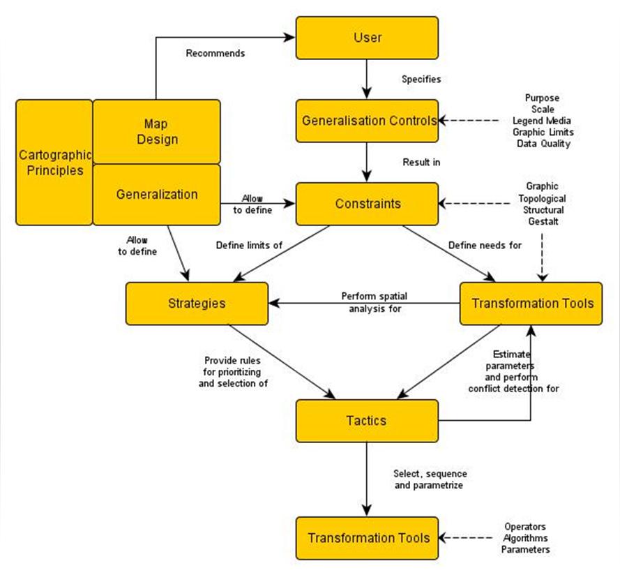
7 Map generalization based on constraints Key aspects of constraints: A constraint can be specified as something to maintain or something to avoid, Aconstraintcanbeabsolute, something to optimize or both, A constraint has an application scope or extent, Aconstraintcanbeintrinsic or extrinsic, Aconstraintcanbeindependent or contextual, Constraints may operate differently at different scales of spatial analysis, Violations of constraints can be detected and evaluated by analyzing micro-, meso- and macroscale data using one or more measures.
8 Map generalization based on constraints AGENT project (Automated GEneralisation and New Technology) 1 A B 2 3 B D C 4 5 A hypothetical network of constraints in a generalization process
9
10
11
12 Task: Topology of map objects must be maintained, roads must maintain its spatial position, roads may be generalized using algorithms for generalization, buildings depending on their surface should be displayed or omitted from the map view, system should assign a cartographic sign to a building if it meets the minimum area request, buildings should be set at a constant distance from roads, buildings should be set parallel to the direction of roads which are nearest to them, roads should not cross buildings, cartographic signs should not be overlap in the map view.

13 Safe Software FME Desktop primarily intended for conversion, transformation, and modifying the spatial raster and vector data FME Workbench, FME Universal Viewer, FME Universal Translator, FME Command-Line Engine interoperability, centralization and retaining attribute data
14 Smoothing using McMaster s algorithm
15 Minor and major roads - a problem in connecting
16 Minor and major roads - a problem in connecting

17 Original data
18 Buildings represented by cartographic signs
19 Buffered roads

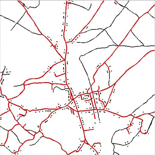
20 Buildings represented by points set on a constant distance from roads
21 Buildings represented by cartographic signs set on a constant distance from roads
22 Buildings set parallel to the direction of roads

23 Buildings crossed by roads
24 Buildings crossed by roads
25 Problem with overlapping
26 Problem with overlapping
27 Vlastiti sustav za automatsku generalizaciju
28 Vlastiti sustav za automatsku generalizaciju

29 Vlastiti sustav za automatsku generalizaciju
30 Vlastiti sustav za automatsku generalizaciju
31
32
33
34
35
36
37 MAS systems and map generalization Advantages: efficiency and effectiveness, robustness and reliability, flexibility and adaptability of the system, reduced costs (in the long run), opportunities for development and reusability of the system. Shortcomings: problem of the assessment of the quality of the final product, large initial investment, some procedures can not be automated at this moment.
38 MAS systems and map generalization Future directions: developing of new and better algorithms for generalization, facilitating quality assessment, post-editing, and representation refinement, creating an adaptive standardized system that automatically derives scale-based settings for generalization operators, parameters, priorities, and other preferences that govern the generalization processes and decisions, integration of more powerful algorithms in commercial software, creating of Web services for generalization and standalone applications for the generalization.
39 MAS systems and map generalization Conclusion: many NMAs and commercial map publishers need generalization in order to derive multiple products from a master database, map generalization using MAS systems and generalization systems has many advantages compared to traditional methods, MAS systems will be able to almost completely replace the manual generalization in the future.
40 Thank you for your attention.
GENERALIZATION IN THE NEW GENERATION OF GIS. Dan Lee ESRI, Inc. 380 New York Street Redlands, CA USA Fax:
 GENERALIZATION IN THE NEW GENERATION OF GIS Dan Lee ESRI, Inc. 380 New York Street Redlands, CA 92373 USA dlee@esri.com Fax: 909-793-5953 Abstract In the research and development of automated map generalization,
Exploring representational issues in the visualisation of geographical phenomenon over large changes in scale.
 Institute of Geography Online Paper Series: GEO-017 Exploring representational issues in the visualisation of geographical phenomenon over large changes in scale. William Mackaness & Omair Chaudhry Institute
Key Words: geospatial ontologies, formal concept analysis, semantic integration, multi-scale, multi-context.
 Marinos Kavouras & Margarita Kokla Department of Rural and Surveying Engineering National Technical University of Athens 9, H. Polytechniou Str., 157 80 Zografos Campus, Athens - Greece Tel: 30+1+772-2731/2637,
FUNDAMENTALS OF GEOINFORMATICS PART-II (CLASS: FYBSc SEM- II)
") FUNDAMENTALS OF GEOINFORMATICS PART-II (CLASS: FYBSc SEM- II) UNIT:-I: INTRODUCTION TO GIS 1.1.Definition, Potential of GIS, Concept of Space and Time 1.2.Components of GIS, Evolution/Origin and Objectives
FUNDAMENTALS OF GEOINFORMATICS PART-II (CLASS: FYBSc SEM- II) UNIT:-I: INTRODUCTION TO GIS 1.1.Definition, Potential of GIS, Concept of Space and Time 1.2.Components of GIS, Evolution/Origin and Objectives
GIS-T 2010 Building a Successful Geospatial Data Sharing Framework: A Ohio DOT Success Story
 GIS-T 2010 Building a Successful Geospatial Data Sharing Framework: A Ohio DOT Success Story ODOT District 2 GIS John Puente District 1 GIS Coordinator\ Planning Administrator 2 Interoperability 3 District
A Summary of State DOT GIS Activities. Presented at the 1999 AASHTO GIS-T Symposium San Diego, CA
 A Summary of State DOT GIS Activities Presented at the 1999 AASHTO GIS-T Symposium San Diego, CA Information Sources Telephone survey of state DOT GIS managers 49 State DOTs surveyed in 1999 Results compared
ArcGIS for Desktop. ArcGIS for Desktop is the primary authoring tool for the ArcGIS platform.
 ArcGIS for Desktop ArcGIS for Desktop ArcGIS for Desktop is the primary authoring tool for the ArcGIS platform. Beyond showing your data as points on a map, ArcGIS for Desktop gives you the power to manage
An Introduction to the Community Maps Information Model
 Esri International User Conference July 23 27 San Diego Convention Center An Introduction to the Community Maps Information Model Seth Sarakaitis Agenda Overview of Community Maps Program Information Models
Solving the European Data Puzzle Simplifying INSPIRE Challenges and Usage. con terra GmbH Dipl.-Ing. Mark Döring
 Solving the European Data Puzzle Simplifying INSPIRE Challenges and Usage con terra GmbH Dipl.-Ing. Mark Döring INSPIRE Reference Projects GeoBAK 2.0 Project // INSPIRE Data & Services The Project Evolution
Cell-based Model For GIS Generalization
 Cell-based Model For GIS Generalization Bo Li, Graeme G. Wilkinson & Souheil Khaddaj School of Computing & Information Systems Kingston University Penrhyn Road, Kingston upon Thames Surrey, KT1 2EE UK
Creating Basemaps to Manage Buildings and Facilities
 Esri International User Conference San Diego, California Technical Workshops July 26, 2012 Creating Basemaps to Manage Buildings and Facilities Mark Stewart and Tamara Yoder Topics for this Session Overview
Esri Production Mapping: Map Automation & Advanced Cartography MADHURA PHATERPEKAR JOE SHEFFIELD
 Esri Production Mapping: Map Automation & Advanced Cartography MADHURA PHATERPEKAR JOE SHEFFIELD Traditional Cartography What you really want Cartographic Workflow Output Cartographic Data Symbology Layout
Automated Generation of Geometrically- Precise and Semantically-Informed Virtual Geographic Environments Populated with Spatially-Reasoning Agents
 Automated Generation of Geometrically- Precise and Semantically-Informed Virtual Geographic Environments Populated with Spatially-Reasoning Agents Mehdi Mekni DISSERTATION.COM Boca Raton Automated Generation
QUALITY CONTROL ROLE IN PROCESS OF ESTABLISHMENT OF NSDI
 QUALITY CONTROL ROLE IN PROCESS OF ESTABLISHMENT OF NSDI S. Lemajić a,lj. Rašić b a Croatian Geodetic Institute, Savska 41/XVI, Zagreb, Croatia slavko.lemajic@cgi.hr b State Geodetic Administration, Lastovska
CARTOGRAPHY in a Web World
 CARTOGRAPHY in a Web World SENSE Research Cluster XIII meeting: Concepts and tools for spatial data visualization BAREND KÖBBEN kobben@itc.nl b.j.kobben@utwente.nl Agenda Short introduction to ITC and
Object-field relationships modelling in an agent-based generalisation model
 11 th ICA workshop on Generalisation and Multiple Representation, 20-21 June 2008, Montpellier, France Object-field relationships modelling in an agent-based generalisation model Julien Gaffuri, Cécile
Imagery and the Location-enabled Platform in State and Local Government
 Imagery and the Location-enabled Platform in State and Local Government Fred Limp, Director, CAST Jim Farley, Vice President, Leica Geosystems Oracle Spatial Users Group Denver, March 10, 2005 TM TM Discussion
British Standard 7666:2006 (parts 0, 1 and 2) its impact & use within local government
 its impact & use within local government") British Standard 7666:2006 (parts 0, 1 and 2) its impact & use within local government geoplace.co.uk Background to British Standard (BS) 7666 BS7666:2006 is one of around 27,000 British Standards. BS7666:2006
British Standard 7666:2006 (parts 0, 1 and 2) its impact & use within local government geoplace.co.uk Background to British Standard (BS) 7666 BS7666:2006 is one of around 27,000 British Standards. BS7666:2006
Paper UC1351. Conference: User Conference Date: 08/10/2006 Time: 8:30am-9:45am Room: Room 23-B (SDCC)
") Conference: User Conference Date: 08/10/2006 Time: 8:30am-9:45am Room: Room 23-B (SDCC) Title of Paper: Increasing the Use of GIS in the Federal Government Author Name: Miss Abstract This presentation
Conference: User Conference Date: 08/10/2006 Time: 8:30am-9:45am Room: Room 23-B (SDCC) Title of Paper: Increasing the Use of GIS in the Federal Government Author Name: Miss Abstract This presentation
Research on Topographic Map Updating
 Research on Topographic Map Updating Ivana Javorovic Remote Sensing Laboratory Ilica 242, 10000 Zagreb, Croatia Miljenko Lapaine University of Zagreb, Faculty of Geodesy Kaciceva 26, 10000 Zagreb, Croatia
ELF products in the ArcGIS platform
 ELF products in the ArcGIS platform Presentation to: Author: Date: NMO Summit 2016, Dublin, Ireland Clemens Portele 18 May 2016 The Building Blocks 18 May, 2016 More ELF users through affiliated platforms
Geographic Analysis of Linguistically Encoded Movement Patterns A Contextualized Perspective
 Geographic Analysis of Linguistically Encoded Movement Patterns A Contextualized Perspective Alexander Klippel 1, Alan MacEachren 1, Prasenjit Mitra 2, Ian Turton 1, Xiao Zhang 2, Anuj Jaiswal 2, Kean
Building a National Data Repository
 Building a National Data Repository Mladen Stojic, Vice President - Geospatial 1/30/2013 2012 Intergraph Corporation 1 Information has meaning and gives power only when shared and distributed. Information,
TERMS OF REFERENCE FOR PROVIDING THE CONSULTANCY SERVICES OF
 1 Cartographic Database and TM100 Product Specifications TERMS OF REFERENCE FOR PROVIDING THE CONSULTANCY SERVICES OF Production and establishment of cartographic database for scale 1:100,000 and production
ArcGIS Web Tools, Templates, and Solutions for Defence & Intelligence. Renee Bernstein Esri Solutions Engineer
 ArcGIS Web Tools, Templates, and Solutions for Defence & Intelligence Renee Bernstein Esri Solutions Engineer ArcGIS Solutions Includes 450+ Industry Focused Apps and Capabilities Organized by 9 Primary
CPSC 695. Future of GIS. Marina L. Gavrilova
 CPSC 695 Future of GIS Marina L. Gavrilova The future of GIS Overview What is GIS now How GIS was viewed before Current trends and developments Future directions of research What is GIS? Internet's definition
Model Generalisation in the Context of National Infrastructure for Spatial Information
 Model Generalisation in the Context of National Infrastructure for Spatial Information Tomas MILDORF and Vaclav CADA, Czech Republic Key words: NSDI, INSPIRE, model generalization, cadastre, spatial planning
Coordination of Humanitarian Assistance: Implications of GIS-based Analysis & Data Modeling for the UNSDI
 Coordination of Humanitarian Assistance: Implications of GIS-based Analysis & Data Modeling for the UNSDI Firoz Verjee UNGIWG Seventh Meeting, Santiago, Chile November 2-4, 2006 EU-STREAM About the ICDRM
Canadian Board of Examiners for Professional Surveyors Core Syllabus Item C 5: GEOSPATIAL INFORMATION SYSTEMS
 Study Guide: Canadian Board of Examiners for Professional Surveyors Core Syllabus Item C 5: GEOSPATIAL INFORMATION SYSTEMS This guide presents some study questions with specific referral to the essential
Learning Computer-Assisted Map Analysis
 Learning Computer-Assisted Map Analysis by Joseph K. Berry* Old-fashioned math and statistics can go a long way toward helping us understand GIS Note: This paper was first published as part of a three-part
Geometric Algorithms in GIS
 Geometric Algorithms in GIS GIS Visualization Software Dr. M. Gavrilova GIS Software for Visualization ArcView GEO/SQL Digital Atmosphere AutoDesk Visual_Data GeoMedia GeoExpress CAVE? Visualization in
LRS Task Force June 13, REVISION HISTORY
 North Carolina Department of Transportation Geographic Information Systems (GIS) Unit LINEAR REFERENCING SYSTEM (LRS) PROJECT DEFINITION Version 1.0 REVISION HISTORY Date Document Manager Revision Purpose
Understanding Geographic Information System GIS
 Understanding Geographic Information System GIS What do we know about GIS? G eographic I nformation Maps Data S ystem Computerized What do we know about maps? Types of Maps (Familiar Examples) Street Maps
Bentley Map Advancing GIS for the World s Infrastructure
 Bentley Map Advancing GIS for the World s Infrastructure Presentation Overview Why would you need Bentley Map? What is Bentley Map? Where is Bentley Map Used? Why would you need Bentley Map? Because your
Development of a Cartographic Expert System
 Development of a Cartographic Expert System Research Team Lysandros Tsoulos, Associate Professor, NTUA Constantinos Stefanakis, Dipl. Eng, M.App.Sci., PhD 1. Introduction Cartographic design and production
Welcome to NR502 GIS Applications in Natural Resources. You can take this course for 1 or 2 credits. There is also an option for 3 credits.
 Welcome to NR502 GIS Applications in Natural Resources. You can take this course for 1 or 2 credits. There is also an option for 3 credits. The 1st credit consists of a series of readings, demonstration,
MODELING ACTIVE DATABASE-DRIVEN CARTOGRAPHY WITHIN GIS DATABASES
 Page 1 of 7 MODELING ACTIVE DATABASE-DRIVEN CARTOGRAPHY WITHIN GIS DATABASES Abstract Charlie Frye and Cory L. Eicher ESRI, 380 New York Street, Redlands, CA 92373 GIS databases contain classes of features
Smart Data Collection and Real-time Digital Cartography
 Smart Data Collection and Real-time Digital Cartography Yuji Murayama and Ko Ko Lwin Division of Spatial Information Science Faculty of Life and Environmental Sciences University of Tsukuba IGU 2013 1
Features and Benefits
 Autodesk LandXplorer Features and Benefits Use the Autodesk LandXplorer software family to help improve decision making, lower costs, view and share changes, and avoid the expense of creating physical
Geospatial capabilities, spatial data and services provided by Military Geographic Service
 Geospatial capabilities, spatial data and services provided by Military Geographic Service LtC Mariyan Markov PhD CONTENTS 1. INTRODUCTION - Workflow - Data sources remote sensing, direct field observation.
Automated generalisation in production at Kadaster
 Automated generalisation in production at Kadaster NL Vincent van Altena 1, Ron Nijhuis 1, Marc Post 1, Ben Bruns 1, Jantien Stoter 1,2 1 Kadaster, The Netherlands, email: firstname.secondname@kadaster.nl
INSPIRATION RESULTS AND BENEFITS ALBANIA
 INSPIRATION RESULTS AND BENEFITS ALBANIA By Eng. Besnik Çomo Paper prepared for E&I Workshop: Support to INSPIRE Implementation in enlargement and EWP Countries JRC ISPRA Central Office of Immovable Property
PC ARC/INFO and Data Automation Kit GIS Tools for Your PC
 ESRI PC ARC/INFO and Data Automation Kit GIS Tools for Your PC PC ARC/INFO High-quality digitizing and data entry Powerful topology building Cartographic design and query Spatial database query and analysis
Multiple Representations with Overrides, and their relationship to DLM/DCM Generalization. Paul Hardy Dan Lee
 Multiple Representations with Overrides, and their relationship to DLM/DCM Generalization Paul Hardy Dan Lee phardy@esri.com dlee@esri.com 1 Context This is a forward-looking presentation, and much of
GIS FOR MAZOWSZE REGION - GENERAL OUTLINE
 GIS FOR MAZOWSZE REGION - GENERAL OUTLINE S. Bialousz 1), K Mączewski 2), E. Janczar 2), K. Osinska-Skotak 1) 1) Warsaw University of Technology, Warsaw, Poland 2) Office of the Surveyor of the Mazowieckie
THE EVOLUTION OF RASTER PROCESSING TECHNOLOGY WITHIN THE CARTOGRAPHIC ENVIRONMENT
 THE EVOLUTION OF RASTER PROCESSING TECHNOLOGY WITHIN THE CARTOGRAPHIC ENVIRONMENT David A. Kolassa Synectics Corporation 310 E. Chestnut Street Rome, NY 13440 BIOGRAPHICAL SKETCH Mr. Kolassa received a
QGIS COURSE - ROUTE ANALYSIS, FINDING THE SHORT PATH IN QGIS ONLINE TRAINING. GIS Training. Course. .com
 Q COURSE - ROUTE ANALYSIS, FINDING THE SHORT PATH IN Q ONLINE TRAINING Training Course.com TYC COURSE GOALS The objective of this course is to initiate the student in route analysis using Q. The training
Transformationof buildings from BDOT10k to ELF
 Transformationof buildings from BDOT10k to ELF Marcin Lebiecki Head Office of Geodesy and Cartography Praha 16-17.04.2015 1 PRESENTATION CONTAINS: Short presentation of source data- BDOT10k Transformation
Using OGC standards to improve the common
 Using OGC standards to improve the common operational picture Abstract A "Common Operational Picture", or a, is a single identical display of relevant operational information shared by many users. The
GIS Generalization Dr. Zakaria Yehia Ahmed GIS Consultant Ain Shams University Tel: Mobile:
 GIS Generalization Dr. Zakaria Yehia Ahmed GIS Consultant Ain Shams University Tel: 24534976 Mobile: 01223384254 zyehia2005@yahoo.com Abstract GIS Generalization makes data less-detailed and less-complex
INTELLIGENT GENERALISATION OF URBAN ROAD NETWORKS. Alistair Edwardes and William Mackaness
 INTELLIGENT GENERALISATION OF URBAN ROAD NETWORKS Alistair Edwardes and William Mackaness Department of Geography, University of Edinburgh, Drummond Street, EDINBURGH EH8 9XP, Scotland, U.K. Tel. 0131
UNIT 4: USING ArcGIS. Instructor: Emmanuel K. Appiah-Adjei (PhD) Department of Geological Engineering KNUST, Kumasi
 Department of Geological Engineering KNUST, Kumasi") UNIT 4: USING ArcGIS Instructor: Emmanuel K. Appiah-Adjei (PhD) Department of Geological Engineering KNUST, Kumasi Getting to Know ArcGIS ArcGIS is an integrated collection of GIS software products ArcGIS
UNIT 4: USING ArcGIS Instructor: Emmanuel K. Appiah-Adjei (PhD) Department of Geological Engineering KNUST, Kumasi Getting to Know ArcGIS ArcGIS is an integrated collection of GIS software products ArcGIS
Open Contextual Cartographic Visualization
 J. Kozel 223 Open Contextual Cartographic Visualization Jiří Kozel Laboratory on Geoinformatics and Cartography, Insitute of Geography, Faculty of Science, Masaryk University, Czech Republic jirikozel@centrum.cz
Production Line Tool Sets
 Production Line Tool Sets Tools for high-quality database production and cartographic output Production Line Tool Sets Production Line Tool Sets (PLTS) by ESRI are a collection of software applications
Innovation in Land Management: Integrated Solutions For National Cadastre Projects
 Success With GIS Innovation in Land Management: Integrated Solutions For National Cadastre Projects XXIII International FIG Congress Munich These documents are only complete, when used in connection with
Enabling ENVI. ArcGIS for Server
 Enabling ENVI throughh ArcGIS for Server 1 Imagery: A Unique and Valuable Source of Data Imagery is not just a base map, but a layer of rich information that can address problems faced by GIS users. >
NR402 GIS Applications in Natural Resources
 NR402 GIS Applications in Natural Resources Lesson 1 Introduction to GIS Eva Strand, University of Idaho Map of the Pacific Northwest from http://www.or.blm.gov/gis/ Welcome to NR402 GIS Applications in
Generalized map production: Italian experiences
 Generalized map production: Italian experiences FIG Working Week 2012 Knowing to manage the territory, protect the environment, evaluate the cultural heritage Rome, Italy, 6-10 May 2012 Gabriele GARNERO,
Comprehensive Winter Maintenance Management System BORRMA-web MDSS inside to increase Road Safety and Traffic Flow
 Thorsten Cypra 1 Comprehensive Winter Maintenance Management System BORRMA-web MDSS inside to increase Road Safety and Traffic Flow American Public Works Association (APWA) Monday, 04/14/2008 3:30 4:30
Spatial Analysis in CyberGIS
 Spatial Analysis in CyberGIS towards a spatial econometrics workbench Luc Anselin, Sergio Rey and Myunghwa Hwang GeoDa Center School of Geographical Sciences and Urban Planning Arizona State University
Improving Map Generalisation of Buildings by Introduction of Urban Context Rules
 Improving Map Generalisation of Buildings by Introduction of Urban Context Rules S. Steiniger 1, P. Taillandier 2 1 University of Zurich, Department of Geography, Winterthurerstrasse 190, CH 8057 Zürich,
CARTOGRAPHIC WEB SERVICES AND CARTOGRAPHIC RULES A NEW APPROACH FOR WEB CARTOGRAPHY
 CARTOGRAPHIC WEB SERVICES AND CARTOGRAPHIC RULES A NEW APPROACH FOR WEB CARTOGRAPHY 1. Introduction Ionut Iosifescu, Marco Hugentobler, Lorenz Hurni ETH Zurich, Institute of Cartography Wolfgang-Pauli-Str.
Increasing GI awareness in local authorities in Poland experiences from the INSPIRE Academy training programme
 Increasing GI awareness in local authorities in Poland experiences from the INSPIRE Academy training programme http://www.akademiainspire.pl Maria Andrzejewska, Monika Rusztecka UNEP/GRID-Warsaw Centre,
Enhancing Parcel Data In Colleton County. February 10, 2009
 Enhancing Parcel Data In Colleton County GIS & CAMA Conference February 10, 2009 Introductions Bruce T. Harper Technology Director Colleton County, SC Bill Wetzel National GIS Account Manager The Sidwell
Karsten Vennemann, Seattle. QGIS Workshop CUGOS Spring Fling 2015
 Karsten Vennemann, Seattle 2015 a very capable and flexible Desktop GIS QGIS QGIS Karsten Workshop Vennemann, Seattle slide 2 of 13 QGIS - Desktop GIS originally a GIS viewing environment QGIS for the
The Road to Improving your GIS Data. An ebook by Geo-Comm, Inc.
 The Road to Improving your GIS Data An ebook by Geo-Comm, Inc. An individual observes another person that appears to be in need of emergency assistance and makes the decision to place a call to 9-1-1.
Oakland County Parks and Recreation GIS Implementation Plan
 Oakland County Parks and Recreation GIS Implementation Plan TABLE OF CONTENTS 1.0 Introduction... 3 1.1 What is GIS? 1.2 Purpose 1.3 Background 2.0 Software... 4 2.1 ArcGIS Desktop 2.2 ArcGIS Explorer
Interactions between Levels in an Agent Oriented Model for Generalisation
 Interactions between Levels in an Agent Oriented Model for Generalisation Adrien Maudet Université Paris-Est, IGN, COGIT, Saint-Mandé, France adrien.maudet@ign.fr Abstract. Generalisation is a complex
Lecture 9: Geocoding & Network Analysis
 Massachusetts Institute of Technology - Department of Urban Studies and Planning 11.520: A Workshop on Geographic Information Systems 11.188: Urban Planning and Social Science Laboratory Lecture 9: Geocoding
GEOGRAPHICAL NAMES ONTOLOGY
 GEOGRAPHICAL NAMES ONTOLOGY Željka JAKIR, Željko HEĆIMOVIĆ, Zvonko ŠTEFAN zeljka.jakir@cgi.hr, zeljko.hecimovic@cgi.hr, zvonko.stefan@cgi.hr 1 CONTENTS: I. About semantic and semantic web of data II. About
Government GIS and its Application for Decision Support
 Government GIS and its Application for Decision Support Zhang Qingpu (Chinese Academy of Surveying and Mapping, Email: zhangqp@casm.ac.cn) Abstract: Application of GIS in government agencies is called
How to Pick a GIS. GIS Software Chapter 8 in Longley, Goodchild, Maguire, and Rhind,, 2001
 How to Pick a GIS GIS Software Chapter 8 in Longley, Goodchild, Maguire, and Rhind,, 2001 How to Pick a GIS Evolution of GIS software Architecture of GIS software Types of software Example products The
Outline. Chapter 1. A history of products. What is ArcGIS? What is GIS? Some GIS applications Introducing the ArcGIS products How does GIS work?
 Outline Chapter 1 Introducing ArcGIS What is GIS? Some GIS applications Introducing the ArcGIS products How does GIS work? Basic data formats The ArcCatalog interface 1-1 1-2 A history of products Arc/Info
SITMUN: Cooperating to Build Local SDIs in the Barcelona Region
 SITMUN: Cooperating to Build Local SDIs in the Barcelona Region Diputació de Barcelona Territory and Sustainability Area Territorial Information Systems Department INSPIRE CONFERENCE Barcelona, September
Atlas of Map Projections: the technology of creation on the basis of program-analytical complex
 Atlas of Map Projections: the technology of creation on the basis of program-analytical complex Zagrebin G.I.* * Moscow State University of Geodesy and Cartography, Science and Education Center of Geoinformation
MEU A cartographic-based web-platform for urban energy management and planning
 MEU A cartographic-based web-platform for urban energy management and planning Massimiliano Capezzali 1, Gaëtan Cherix 2, 1 Energy Center, Ecole Polytechnique Fédérale de Lausanne (EPFL), 1015 Lausanne
Strategies for Integrating CAD and BIM in ArcGIS. Don Kuehne Esri 3D Product Manager: CAD/BIM/AEC
 Strategies for Integrating CAD and BIM in ArcGIS Don Kuehne Esri 3D Product Manager: CAD/BIM/AEC CAD Digital Drawing CAD in ArcGIS Desktop CAD in Desktop CAD as Data CAD as a Map EXPORT TO CAD Create and
Children s Understanding of Generalisation Transformations
 Children s Understanding of Generalisation Transformations V. Filippakopoulou, B. Nakos, E. Michaelidou Cartography Laboratory, Faculty of Rural and Surveying Engineering National Technical University
Fundamental Base of Topographic Data of Czech Land Survey Office as a Source for Database Cartography and other applications.
 Fundamental Base of Topographic Data of Czech Land Survey Office as a Source for Database Cartography and other applications. Pavel Šidlichovský, Head of ZABAGED Administration Section Zeměměřický úřad
Flood Hazard Zone Modeling for Regulation Development
 Flood Hazard Zone Modeling for Regulation Development By Greg Lang and Jared Erickson Pierce County GIS June 2003 Abstract The desire to blend current digital information with government permitting procedures,
EuroSDR (European Spatial Data Research)
") EuroSDR (European Spatial Data Research) ROLLING RESEARCH PLAN 2015-2018 EuroSDR Secretariat Public Governance Institute KU Leuven Parkstraat 45 bus 3609 3000 Leuven Belgium Tel.: +32 16 32 31 80 Fax:
EuroSDR (European Spatial Data Research) ROLLING RESEARCH PLAN 2015-2018 EuroSDR Secretariat Public Governance Institute KU Leuven Parkstraat 45 bus 3609 3000 Leuven Belgium Tel.: +32 16 32 31 80 Fax:
presents challenges related to utility infrastructure planning. Many of these challenges
 1 Introduction: - a. Purpose According to U.S. Census Bureau the population of stark county was 367,585 in 1990, and in 2000 it was increase to 378,098. Thus County is experiencing a growth that presents
AN ATTEMPT TO AUTOMATED GENERALIZATION OF BUILDINGS AND SETTLEMENT AREAS IN TOPOGRAPHIC MAPS
 AN ATTEMPT TO AUTOMATED GENERALIZATION OF BUILDINGS AND SETTLEMENT AREAS IN TOPOGRAPHIC MAPS M. Basaraner * and M. Selcuk Yildiz Technical University (YTU), Department of Geodetic and Photogrammetric Engineering,
Models to carry out inference vs. Models to mimic (spatio-temporal) systems 5/5/15
 systems 5/5/15") Models to carry out inference vs. Models to mimic (spatio-temporal) systems 5/5/15 Ring-Shaped Hotspot Detection: A Summary of Results, IEEE ICDM 2014 (w/ E. Eftelioglu et al.) Where is a crime source?
Models to carry out inference vs. Models to mimic (spatio-temporal) systems 5/5/15 Ring-Shaped Hotspot Detection: A Summary of Results, IEEE ICDM 2014 (w/ E. Eftelioglu et al.) Where is a crime source?
ISO Series Standards in a Model Driven Architecture for Landmanagement. Jürgen Ebbinghaus, AED-SICAD
 ISO 19100 Series Standards in a Model Driven Architecture for Landmanagement Jürgen Ebbinghaus, AED-SICAD 29.10.2003 The Company 100% SIEMENS PTD SIEMENS Business Services Shareholder & Strategic Business
CyberGIS: What Still Needs to Be Done? Michael F. Goodchild University of California Santa Barbara
 CyberGIS: What Still Needs to Be Done? Michael F. Goodchild University of California Santa Barbara Progress to date Interoperable location referencing coordinate transformations geocoding addresses point-of-interest
3D BUILDING MODELS IN GIS ENVIRONMENTS
 A. N. Visan 3D Building models in GIS environments 3D BUILDING MODELS IN GIS ENVIRONMENTS Alexandru-Nicolae VISAN, PhD. student Faculty of Geodesy, TUCEB, alexvsn@yahoo.com Abstract: It is up to us to
AN OBJECT-ORIENTED DATA MODEL FOR DIGITAL CARTOGRAPHIC OBJECT
 AN OBJECT-ORIENTED DATA MODEL FOR DIGITAL CARTOGRAPHIC OBJECT Chen Yijin China University of Mining Technology (Beijing) 100083 Email :Y.J.Chen@263.net GuBin 1521,No.15 XinXingDongXiang XiZhiMenWai Beijing
Geographic Systems and Analysis
 Geographic Systems and Analysis New York University Robert F. Wagner Graduate School of Public Service Instructor Stephanie Rosoff Contact: stephanie.rosoff@nyu.edu Office hours: Mondays by appointment
Digitization in a Census
 Topics Connectivity of Geographic Data Sketch Maps Data Organization and Geodatabases Managing a Digitization Project Quality and Control Topology Metadata 1 Topics (continued) Interactive Selection Snapping
14.2 Weather impacts and routing services in support of airspace management operations. David I. Knapp, Jeffrey O. Johnson, David P.
 14.2 Weather impacts and routing services in support of airspace management operations David I. Knapp, Jeffrey O. Johnson, David P. Sauter U.S. Army Research Laboratory, Battlefield Environment Division,
Application of GIS in Public Transportation Case-study: Almada, Portugal
 Case-study: Almada, Portugal Doutor Jorge Ferreira 1 FSCH/UNL Av Berna 26 C 1069-061 Lisboa, Portugal +351 21 7908300 jr.ferreira@fcsh.unl.pt 2 FSCH/UNL Dra. FCSH/UNL +351 914693843, leite.ines@gmail.com
Perseverance. Experimentation. Knowledge.
 2410 Intuition. Perseverance. Experimentation. Knowledge. All are critical elements of the formula leading to breakthroughs in chemical development. Today s process chemists face increasing pressure to
Oregon Department of Transportation. Geographic Information Systems Strategic Plan
 Oregon Department of Transportation Geographic Information Systems Strategic Plan Adopted May, 2000 By the GIS Steering Committee Last printed 10/2/2012 4:20:00 PM Page Geographic Information Systems Strategic
Open spatial data infrastructure
 Open spatial data infrastructure a backbone for digital government Thorben Hansen Geomatikkdagene 2018 Stavanger 13.-15. mars Spatial Data Infrastructure definition the technology, policies, standards,
Research on Object-Oriented Geographical Data Model in GIS
 Research on Object-Oriented Geographical Data Model in GIS Wang Qingshan, Wang Jiayao, Zhou Haiyan, Li Bin Institute of Information Engineering University 66 Longhai Road, ZhengZhou 450052, P.R.China Abstract
Towards Automatic Nanomanipulation at the Atomic Scale
 Towards Automatic Nanomanipulation at the Atomic Scale Bernd Schütz Department of Computer Science University of Hamburg, Germany Department of Computer Science Outline Introduction System Overview Workpackages
Ready for INSPIRE.... connecting worlds. European SDI Service Center
 Ready for INSPIRE Consultancy SOFTWARE T r a i n i n g Solutions... connecting worlds European SDI Service Center Increasing Added Value with INSPIRE and SDI Components INSPIRE In 2007, the European Commission
Esri Training by Microcenter Prepare to Innovate. Microcenter Course Catalog
 Esri Training by Microcenter Prepare to Innovate 2015 Instructor-Led Courses Microcenter Course Catalog ArcGIS Foundational Courses Designed to meet the learning needs of professionals whose GIS experience
"GIS-Sofia" Ltd. geospatial data integration in SOFCAR geographic information system and providing services March 2018, Sofia
 "GIS-Sofia" Ltd. geospatial data integration in SOFCAR geographic information system and providing services Geographical Information System Sofia " Ltd....the beginning... Established in 1999, as a Sofia