Carat: Collaborative Energy Diagnosis on Mobile Devices
|
|
|
- Aleesha Wilkerson
- 6 years ago
- Views:
Transcription
1 Carat: Collaborative Energy Diagnosis on Mobile Devices Adam J. Oliner Kuro Labs AMP Lab, UC Berkeley Anand P. Iyer and Ion Stoica AMP Lab, UC Berkeley Eemil Lagerspetz and Sasu Tarkoma U of Helsinki


2 Mobile is Hot... sometimes, literally: 2

3 A Day in the Life 3
4 A Day in the Life 3

5 A Day in the Life 3

6 A Day in the Life 3
7 A Day in the Life 3

8 A Day in the Life 3

9 A Day in the Life 3
10 A Day in the Life 3

11 A Day in the Life 3
12 Users Questions Why is my battery draining? Is that normal? What can I do about it? 4
13 Today 1. Carat 2. Sampling to Diagnosis 3. Dealing with Uncertainty 4. Implementation 5. Deployment 5
14 1. Carat
15 Prior Approaches Ad hoc e.g., no-sleep bug Intrusive Generic Kill all background apps Dim the screen 7

16 Prior Approaches Ad hoc e.g., no-sleep bug Intrusive Generic Kill all background apps Dim the screen 7
17 the crowd the cloud big data instrumentation data raw and derived data Spark on EC2 DynamoDB and S3 actions and reports statistical analysis Our Approach
18 the crowd the cloud big data instrumentation data raw and derived data Spark on EC2 DynamoDB and S3 actions and reports statistical analysis First collaborative approach for diagnosing energy problems. Our Approach
19 Why Collaborative? Enables diagnosis Nearly impossible on a single device Normal? Trigger? Severity? Frequency? Distribute instrumentation overhead Compensate for biases and uncertainty 9
20 Design Goals Most invasive method that works on both Android and ios Eligible for Apple s App Store Investigate how far we can take diagnosis 10
21 Carat Mobile app for ios and Android Personalized energy debugging What is misbehaving Whether that is normal What you can do about it How much it will help 11
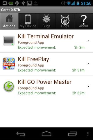

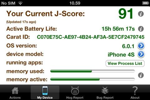

22 Carat
23 Operating Instructions Install Carat on your ios/android device Open daily+ for about a week Perform the actions it suggests Open occasionally for new actions 13

24 Privacy Concerns Opt-in EULA, prior to installation Nothing personally identifying Sampled data shown within the app 14
25 Open Source Both apps are on github FreeBSD license Analysis code is proprietary carat.cs.berkeley.edu 15
26 2. Sampling to Diagnosis
27 t 1 WiFi? ios 5.1?... Carat Sampling
28 t 1 WiFi? ios 5.1?... t 2 WiFi? ios 5.1?... Carat Sampling
29 t 1 WiFi? ios 5.1?... t 2 WiFi? ios 5.1?... t 3 WiFi? ios 5.1?... Carat Sampling

30 t 1 WiFi? ios 5.1?... t 2 WiFi? ios 5.1?... t 3 WiFi? ios 5.1?... t 4 WiFi? ios 5.1?... Carat Sampling
31 t 1 WiFi? ios 5.1?... t 2 WiFi? ios 5.1?... Computing Rates
32 t 1 WiFi? ios 5.1?... t t 2 WiFi? ios 5.1?... t Computing Rates
33 t 1 WiFi? ios 5.1?... % t 2 WiFi? ios 5.1?... % = discharge rate (%/s) t Computing Rates
34 t 1 WiFi? ios 5.1?... F t 2 WiFi? ios 5.1?... % = discharge rate (%/s) t F Computing Rates
35 F Probability Energy Rate (% / s) Energy Anomalies
36 F Probability Energy Rate (% / s) Energy Anomalies
37 F Probability Energy Rate (% / s) Energy Anomalies
38 energy hog F Probability Energy Rate (% / s) Energy Anomalies
39 Probability Energy Rate (% / s) Energy Anomalies
40 Probability Energy Rate (% / s) Without the crowd, there is no way to Energy Anomalies know whether this use is normal.
41 (Given is not a Hog.) Probability Energy Rate (% / s) Energy Anomalies
42 (Given is not a Hog.) energy bug Probability Energy Rate (% / s) Energy Anomalies
43 Original Distribution Probability Energy Rate (% / s) 21
44 Original Distribution E[reference] E[subject] Probability Energy Rate (% / s) 21
45 Original Distribution E[reference] E[subject] Probability D Energy Rate (% / s) 21
46 Mean Distribution E[subject] E[reference] Probability E[Energy Rate] (% / s) 22
47 Error and Confidence EV Probability E[Energy Rate] (% / s) 23
48 Error and Confidence EV ± e %/s 50% confidence Probability E[Energy Rate] (% / s) 23
49 Error and Confidence EV ± E %/s 95% confidence Probability E[Energy Rate] (% / s) 23
50 Probability Confidence Factors Energy Rate (% / s) EV 24
51 Probability Confidence Factors Energy Rate (% / s) EV 24
52 Probability Confidence Factors Energy Rate (% / s) EV 24
53 Significant Probability μ 2 μ 1 ε 2 d' ε 1 Subject Reference E[Battery Drain (% / s)] 25
54 Probability Probability Probability Classification Energy Rate (% / s) not-f F Energy Rate (% / s) Energy Rate (% / s) 26
55 Probability Probability Probability Classification Energy Rate (% / s) not-f F Energy Rate (% / s) Energy Rate (% / s) 26
56 Probability Probability Probability Classification Energy Rate (% / s) not-f F Energy Rate (% / s) Energy Rate (% / s) 26
57 Diagnosis a not-v x 27
58 Diagnosis a Killing app a will give x±e of battery life not-v (95% confidence), as would upgrading the x OS to version v. 27
59 3. Dealing with Uncertainty
60 Trigger Measured % Actual % BatteryLevelChanged x x else x (x-5, x] Measurement Uncertainty
61 Trigger Measured % Actual % BatteryLevelChanged x x else x (x-5, x] 85% 85% Measurement Uncertainty
62 Trigger Measured % Actual % BatteryLevelChanged x x else x (x-5, x] 85% 85% 85% (80%,85%] Measurement Uncertainty
63 Trigger Measured % Actual % BatteryLevelChanged x x else x (x-5, x] 85% 85% Prior 85% (80%,85%] Measurement Uncertainty
64 Probability Prior Energy Rate (% / s) Measurement Uncertainty
65 Battery % Time actual Probability Prior Energy Rate (% / s) Measurement Uncertainty
66 Battery % x x x x actual samples Time Probability Prior Energy Rate (% / s) Measurement Uncertainty
67 Battery % x x x x actual samples Time Probability Prior Energy Rate (% / s) Measurement Uncertainty
68 Battery % x x x x actual samples x Time y Probability Prior Energy Rate (% / s) Measurement Uncertainty
69 Battery % x x x x actual samples x Time y y Probability x Prior Energy Rate (% / s) Measurement Uncertainty


70 Ground Truth Does sampling match reality? What does sampling cost? 31
71 Ground Truth iphone 4S + Monsoon Power Monitor Galaxy Tab Leyden Energy Usage scripts 32
72 Customer Service
73 Ground Truth Battery indicator agrees with the monitor :00 00:30 01:00 01:30 02:00 02:30 03:00 03:30 04:00 Battery level (%) On-Screen Battery Indicator [Redacted] Carat Samples Samples Power Monitor with Carat [Redacted] Samples Power Monitor with Weather Time (HH:MM) 34
74 Ground Truth Good accuracy with low overhead Density Power Monitor (w/ Carat) Power Monitor (w/out Carat) Carat Energy Discharge Rate (%/s) 35
75 Ground Truth Discharge rate estimation Android: %/sec ios: %/sec Overhead 3.5% of the battery less than Weather Less than experimental imprecision 36
76 4. Implementation
77 the crowd the cloud big data instrumentation data raw and derived data Spark on EC2 DynamoDB and S3 actions and reports statistical analysis Carat Infrastructure
78 Spark Cluster computing framework Resilient Distributed Datasets (RDDs) Read-only in-memory data structures Parallel operations (e.g., reduce) Iterative or interactive workloads 39
79 Rates to Distributions Rate RDDs from sample pairs Compute conditional distributions Leverage Spark parallelism r 1 ĉ map c r {0,1} r n ĉ c r {0,1} reduce map c c r... count r count groupby c c {{r,count}}... {{r,count}} 40
80 Server Traffic Bandwidth (bytes/s) Actual 1 byte/sec/client Number of Clients 41
81 Parallelization 42
82 5. Deployment
83 Initial Deployment TestFlight over-the-air beta 100 sign-ups (Apple s max) 75 installs Collected 10,000+ samples 44
84 Initial Results Found 35 apps exhibiting energy bugs e.g., Facebook, Kindle, Flipboard Corroborated with forum posts, news articles, and data correlations Injected three bugs in Wikipedia Detected all of them 45
85 Suddenly...
86 Suddenly...
87 Suddenly...
88 Suddenly...
89 Suddenly...
90 Carat went viral. In 24 hours, there were dozens of articles and we had more than 100,000 users. Suddenly...
91 Carat Today 450,000+ devices 60% ios 40% Android Tens of millions of samples 47
92 Energy Anomalies Hogs 11,256 hogs (9.4%) e.g., Pandora and Skype Bugs 483,354 buggy instances (5.3%) e.g., Kindle, Facebook, and YouTube 48

93 Kindle Bug (ios) E-book reader Bug on 3.9% of clients Forum: WhisperSync Confirmed by our data Turn on WiFi 36m improvement 49
94 Kindle Diagnosis Network Off 12.5 h With Kindle 8.4 h 3G 6.3 h Wi-Fi 6.9 h Without Kindle 7.7 h 50

95 Twitter Bug (Android) Microblogging app Bug on 14.9% of clients MCAD implicates OS WiFi also helps Upgrade to ICS m improvement 51
96 Battery Life +10% after 10 days +30% after 90+ days Relative Battery Life Days Since First Report 52
97 Error Convergence Error bounds converge in practice Relative EV and Error Sample Count Expected Value Error Upper Bound Error Lower Bound 53
98 Prediction Accuracy 95.4% within confidence bounds Empirical Slope Perfect Prediction Within 95% Confidence Bounds Outside 95% Confidence Bounds Projected Slope 54
99 Positive Feedback Carat has given me control of my phone in a way I never had before. Thank you! :-D In closing, I just want to say thank you & keep up the great work w/carat. It has to be one favorite apps on my Droid. I ve been measuring my battery with and without its recommendations for the past month, and I m getting about extra minutes of battery life from my phone just wanted to tell you that I love your app - in fact, it s the only one that I keep running all the time on my iphone 5. I absolutely love the app. Very, very useful. I love this app. Very very very useful. 55
100 the crowd the cloud big data instrumentation data raw and derived data Spark on EC2 DynamoDB and S3 actions and reports statistical analysis Our Approach
101 the crowd the cloud big data link structure A links-to B The Google Model

102 the crowd the cloud big data link structure A links-to B search PageRank The Google Model
103 the crowd the cloud big data A friends-with B social platform The Facebook Model
104 the crowd the cloud big data personal data A friends-with B social platform The Facebook Model
105 the crowd the cloud big data To define and build the layer between the crowd and big data. This layer extracts data and computation from the crowd, and extracts value from big data for the crowd. AMP Lab Vision
106 the crowd the cloud big data instrumentation data raw and derived data dsa gfdg gfdg gfdg gfdw hy dsa gfdg gfdg gfdg gfdw hy dsa gfdg gfdg gfdg gfdw hy dsa gfdg gfdg gfdg gfdw hy actions and reports statistical analysis Kuro Labs
107 the crowd the cloud big data instrumentation data raw and derived data dsa gfdg gfdg gfdg gfdw hy dsa gfdg gfdg gfdg gfdw hy dsa gfdg gfdg gfdg gfdw hy dsa gfdg gfdg gfdg gfdw hy actions and reports statistical analysis Kuro Labs
108 the crowd the cloud big data instrumentation data raw and derived data X actions and reports statistical analysis dsa gfdg gfdg gfdg gfdw hy dsa gfdg gfdg gfdg gfdw hy dsa gfdg gfdg gfdg gfdw hy dsa gfdg gfdg gfdg gfdw hy Kuro Labs
109 the crowd the cloud big data instrumentation data raw and derived data X actions and reports statistical analysis dsa gfdg gfdg gfdg gfdw hy dsa gfdg gfdg gfdg gfdw hy dsa gfdg gfdg gfdg gfdw hy dsa gfdg gfdg gfdg gfdw hy Kuro Labs
110 the crowd the cloud big data instrumentation data raw and derived data X actions and reports statistical analysis dsa gfdg gfdg gfdg gfdw hy dsa gfdg gfdg gfdg gfdw hy dsa gfdg gfdg gfdg gfdw hy dsa gfdg gfdg gfdg gfdw hy Kuro Labs
111 the crowd the cloud big data instrumentation data raw and derived data X actions and reports statistical analysis dsa gfdg gfdg gfdg gfdw hy dsa gfdg gfdg gfdg gfdw hy dsa gfdg gfdg gfdg gfdw hy dsa gfdg gfdg gfdg gfdw hy Kuro Labs
112 the crowd the cloud big data instrumentation data raw and derived data X actions and reports statistical analysis dsa gfdg gfdg gfdg gfdw hy dsa gfdg gfdg gfdg gfdw hy dsa gfdg gfdg gfdg gfdw hy dsa gfdg gfdg gfdg gfdw hy Kuro Labs

113 the crowd the cloud big data instrumentation data raw and derived data X actions and reports statistical analysis dsa gfdg gfdg gfdg gfdw hy dsa gfdg gfdg gfdg gfdw hy dsa gfdg gfdg gfdg gfdw hy dsa gfdg gfdg gfdg gfdw hy Stats as a Service Kuro Labs
114 Next Steps API for developers New application domains Deploy to the crowd; diagnose in the cloud Platform for collaborative diagnosis Statistics as a service kuro-labs.com 61
115 Fin You have reached the end of the presentation. Please turn back. 62
Mobility Analytics through Social and Personal Data. Pierre Senellart
 Mobility Analytics through Social and Personal Data Pierre Senellart Session: Big Data & Transport Business Convention on Big Data Université Paris-Saclay, 25 novembre 2015 Analyzing Transportation and
personal weather station
 personal weather station Master your own climate measurements on your smartphone TRAINING BOOK Pitch The Netatmo Personal Weather Station helps you master your own climate measurements on your smartphone.
Introduction to Portal for ArcGIS
 Introduction to Portal for ArcGIS Derek Law Product Management March 10 th, 2015 Esri Developer Summit 2015 Agenda Web GIS pattern Product overview Installation and deployment Security and groups Configuration
ArcGIS is Advancing. Both Contributing and Integrating many new Innovations. IoT. Smart Mapping. Smart Devices Advanced Analytics
 ArcGIS is Advancing IoT Smart Devices Advanced Analytics Smart Mapping Real-Time Faster Computing Web Services Crowdsourcing Sensor Networks Both Contributing and Integrating many new Innovations ArcGIS
Portal for ArcGIS: An Introduction
 Portal for ArcGIS: An Introduction Derek Law Esri Product Management Esri UC 2014 Technical Workshop Agenda Web GIS pattern Product overview Installation and deployment Security and groups Configuration
Introduction to Portal for ArcGIS. Hao LEE November 12, 2015
 Introduction to Portal for ArcGIS Hao LEE November 12, 2015 Agenda Web GIS pattern Product overview Installation and deployment Security and groups Configuration options Portal for ArcGIS + ArcGIS for
Portal for ArcGIS: An Introduction. Catherine Hynes and Derek Law
 Portal for ArcGIS: An Introduction Catherine Hynes and Derek Law Agenda Web GIS pattern Product overview Installation and deployment Configuration options Security options and groups Portal for ArcGIS
ArcGIS Enterprise: What s New. Philip Heede Shannon Kalisky Melanie Summers Sam Williamson
 ArcGIS Enterprise: What s New Philip Heede Shannon Kalisky Melanie Summers Sam Williamson ArcGIS Enterprise is the new name for ArcGIS for Server What is ArcGIS Enterprise ArcGIS Enterprise is powerful
SOCIAL MEDIA IN THE COMMUNICATIONS CENTRE
 SOCIAL MEDIA IN THE COMMUNICATIONS CENTRE Karen Gordon Gordon Strategy www.gordonstrategy.ca v 1 WHAT WE ARE GOING TO TALK ABOUT TODAY T h e s o c i a l m e d i a i n c i d e n t W h a t c a n h a p p
Web GIS Administration: Tips and Tricks
 EdUC 2017 July 8 th, 2017 Web GIS Administration: Tips and Tricks Geri Miller Agenda Concerns Acknowledged User Management Content Management Monitoring Licensing and logins Sophistication of IT support
Arcgis Enterprise Performance And Scalability Best Practices
 Arcgis Enterprise Performance And Scalability Best Practices We have made it easy for you to find a PDF Ebooks without any digging. And by having access to our ebooks online or by storing it on your computer,
What Would John Snow Do (Today)? Part 1
? Part 1") What Would John Snow Do (Today)? Part 1 Tanya Bigos and Derek Law @Tanyabigos @GIS_Bandit Thurs Oct 19 th, 2017 Outline Overview of the ArcGIS Platform Whiteboard discussion Summary Questions A Whole New
What Would John Snow Do (Today)? Part 1 Tanya Bigos and Derek Law @Tanyabigos @GIS_Bandit Thurs Oct 19 th, 2017 Outline Overview of the ArcGIS Platform Whiteboard discussion Summary Questions A Whole New
Reimaging GIS: Geographic Information Society. Clint Brown Linda Beale Mark Harrower Esri
 Reimaging GIS: Geographic Information Society Clint Brown Linda Beale Mark Harrower Esri 8 billion = Number of basemap requests per month on AGOL 14,000 = Unique requests per second 12,000 = New Items
ITIL and DevOps Kaimar Karu Head of Product Strategy and Development, AXELOS
 ITIL and DevOps Kaimar Karu Head of Product Strategy and Development, AXELOS THE CHALLENGE P R O C E S S M A N A G E M E N T C O M M O N A N T I - PAT T E R N S» By-the-book ITIL implementations» Ideal
Trends, Helpouts and Hidden Gems: Additional Google Tools to Strengthen Your Brand
 Trends, Helpouts and Hidden Gems: Additional Google Tools to Strengthen Your Brand a bit about me Father, husband of Kathy, Milan and Savannah Head of Social Strategy at WCG, a W2O Company Adjunct Professor,
Leveraging ArcGIS Online Elevation and Hydrology Services. Steve Kopp, Jian Lange
 Leveraging ArcGIS Online Elevation and Hydrology Services Steve Kopp, Jian Lange Topics An overview of ArcGIS Online Elevation Analysis Using Elevation Analysis Services in ArcGIS for Desktop Using Elevation
Leveraging Web GIS: An Introduction to the ArcGIS portal
 Leveraging Web GIS: An Introduction to the ArcGIS portal Derek Law Product Management DLaw@esri.com Agenda Web GIS pattern Product overview Installation and deployment Configuration options Security options
Web GIS & ArcGIS Pro. Zena Pelletier Nick Popovich
 Web GIS & ArcGIS Pro Zena Pelletier Nick Popovich Web GIS Transformation of the ArcGIS Platform Desktop Apps GIS Web Maps Web Scenes Layers Evolution of the modern GIS Desktop GIS (standalone GIS) GIS
Esri Overview for Mentor Protégé Program:
 Agenda Passionate About Helping You Succeed Esri Overview for Mentor Protégé Program: Northrop Grumman CSSS Jeff Dawley 3 September 2010 Esri Overview ArcGIS as a System ArcGIS 10 - Map Production - Mobile
Web GIS Deployment for Administrators. Vanessa Ramirez Solution Engineer, Natural Resources, Esri
 Web GIS Deployment for Administrators Vanessa Ramirez Solution Engineer, Natural Resources, Esri Agenda Web GIS Concepts Web GIS Deployment Patterns Components of an On-Premises Web GIS Federation of Server
Exploring Human Mobility with Multi-Source Data at Extremely Large Metropolitan Scales. ACM MobiCom 2014, Maui, HI
 Exploring Human Mobility with Multi-Source Data at Extremely Large Metropolitan Scales Desheng Zhang & Tian He University of Minnesota, USA Jun Huang, Ye Li, Fan Zhang, Chengzhong Xu Shenzhen Institute
Degree (k)
") 0 1 Pr(X k) 0 0 1 Degree (k) Figure A1: Log-log plot of the complementary cumulative distribution function (CCDF) of the degree distribution for a sample month (January 0) network is shown (blue), along
0 1 Pr(X k) 0 0 1 Degree (k) Figure A1: Log-log plot of the complementary cumulative distribution function (CCDF) of the degree distribution for a sample month (January 0) network is shown (blue), along
Generative Models for Discrete Data
 Generative Models for Discrete Data ddebarr@uw.edu 2016-04-21 Agenda Bayesian Concept Learning Beta-Binomial Model Dirichlet-Multinomial Model Naïve Bayes Classifiers Bayesian Concept Learning Numbers
RainMachine Mini- 8 Quick- Start Guide
 RainMachine Mini- 8 Quick- Start Guide Table of Contents Inside the Box... 3 Wiring Diagram... 4 Hardware Installation... 5 Initial Setup... 6 How it works... 13 Operation... 8 Program Properties... 10
Collaborative WRF-based research and education enabled by software containers
 Collaborative WRF-based research and education enabled by software containers J. Hacker, J. Exby, K. Fossell National Center for Atmospheric Research Contributions from Tim See (U. North Dakota) 1 Why
ArcGIS Enterprise: What s New. Philip Heede Shannon Kalisky Melanie Summers Shreyas Shinde
 ArcGIS Enterprise: What s New Philip Heede Shannon Kalisky Melanie Summers Shreyas Shinde ArcGIS Enterprise is the new name for ArcGIS for Server ArcGIS Enterprise Software Components ArcGIS Server Portal
DANIEL WILSON AND BEN CONKLIN. Integrating AI with Foundation Intelligence for Actionable Intelligence
 DANIEL WILSON AND BEN CONKLIN Integrating AI with Foundation Intelligence for Actionable Intelligence INTEGRATING AI WITH FOUNDATION INTELLIGENCE FOR ACTIONABLE INTELLIGENCE in an arms race for artificial
Weather for the Road: a Mobile Solution
 Weather for the Road: a Mobile Solution Philippe Tissot & Darius Stephen Conrad Blucher Institute David Fonseca, Hoang Chau, Duc Tran, Laura Pulgarin & Selvy Letlora The Innovation Center Texas A&M University-Corpus
The Infinite Dial 2019
 The Infinite Dial 2019 Study Overview The Infinite Dial is the longest-running survey of digital media consumer behavior in America The annual reports in this series have covered a wide range of digital
D2D SALES WITH SURVEY123, OP DASHBOARD, AND MICROSOFT SSAS
 D2D SALES WITH SURVEY123, OP DASHBOARD, AND MICROSOFT SSAS EDWARD GAUSE, GISP DIRECTOR OF INFORMATION SERVICES (ENGINEERING APPS) HTC (HORRY TELEPHONE COOP.) EDWARD GAUSE, GISP DIRECTOR OF INFORMATION
The File Geodatabase API. Craig Gillgrass Lance Shipman
 The File Geodatabase API Craig Gillgrass Lance Shipman Schedule Cell phones and pagers Please complete the session survey we take your feedback very seriously! Overview File Geodatabase API - Introduction
SpyMeSat Mobile App. Imaging Satellite Awareness & Access
 SpyMeSat Mobile App Imaging Satellite Awareness & Access Imaging & Geospatical Technology Forum ASPRS Annual Conference March 12-16, 2017 Baltimore, MD Ella C. Herz 1 Orbit Logic specializes in software
Working with ArcGIS Online
 Esri International User Conference San Diego, CA Technical Workshops July 12, 2011 Working with ArcGIS Online Bern Szukalski, Deane Kensok Topics for this Session ArcGIS Online Overview ArcGIS Online Content
Introduction to Google Mapping Tools
 Introduction to Google Mapping Tools Google s Mapping Tools Explore geographic data. Organize your own geographic data. Visualize complex data. Share your data with the world. Tell your story and educate
GIS Workshop Data Collection Techniques
 GIS Workshop Data Collection Techniques NOFNEC Conference 2016 Presented by: Matawa First Nations Management Jennifer Duncan and Charlene Wagenaar, Geomatics Technicians, Four Rivers Department QA #: FRG
PI SERVER 2012 Do. More. Faster. Now! Copyr i g h t 2012 O S Is o f t, L L C. 1
 PI SERVER 2012 Do. More. Faster. Now! Copyr i g h t 2012 O S Is o f t, L L C. 1 AUGUST 7, 2007 APRIL 14, 2010 APRIL 24, 2012 Copyr i g h t 2012 O S Is o f t, L L C. 2 PI Data Archive Security PI Asset
Not All Apps Are Created Equal:
 Not All Apps Are Created Equal: Analysis of Spatiotemporal Heterogeneity in Nationwide Mobile Service Usage Cristina Marquez and Marco Gramaglia (Universidad Carlos III de Madrid); Marco Fiore (CNR-IEIIT);
Designing Information Devices and Systems I Summer 2017 D. Aranki, F. Maksimovic, V. Swamy Homework 5
 EECS 16A Designing Information Devices and Systems I Summer 2017 D. Aranki, F. Maksimovic, V. Swamy Homework 5 This homework is due on Sunday, July 23, 2017, at 23:59. Self-grades are due on Monday, July
inaturalist Training AOP inaturalist Training May 21, 2016 Slide 1
 inaturalist Training AOP inaturalist Training May 21, 2016 Slide 1 What is inaturalist? inaturalist is a free tool that allows people to record, share, and discuss their observations inaturalist is designed
Overview of ArcGIS Enterprise August 24, Dan Haag ESRI
 Overview of ArcGIS Enterprise August 24, 2017 Dan Haag ESRI Sharing to a portal ArcGIS 10.3 portal Central destination for all of your geospatial assets in Web GIS - ArcGIS Online organization and/or Portal
Introduction to Google Drive Objectives:
 Introduction to Google Drive Objectives: Learn how to access your Google Drive account Learn to create new documents using Google Drive Upload files to store on Google Drive Share files and folders with
Build relationships not link. Scott Wyden Kivowitz
 Digital Agency Build relationships not link. Scott Wyden Kivowitz Company book yoursocialnoise.digital #progettinoise Digital Agency Hi! #progettinoise We are yoursocialnoise! A young Digital Agency that
One Optimized I/O Configuration per HPC Application
 One Optimized I/O Configuration per HPC Application Leveraging I/O Configurability of Amazon EC2 Cloud Mingliang Liu, Jidong Zhai, Yan Zhai Tsinghua University Xiaosong Ma North Carolina State University
ArcGIS GeoAnalytics Server: An Introduction. Sarah Ambrose and Ravi Narayanan
 ArcGIS GeoAnalytics Server: An Introduction Sarah Ambrose and Ravi Narayanan Overview Introduction Demos Analysis Concepts using GeoAnalytics Server GeoAnalytics Data Sources GeoAnalytics Server Administration
Changes in Esri GIS, practical ways to be ready for the future
 Changes in Esri GIS, practical ways to be ready for the future John Sharrard, Esri April 16, 2015 The only thing that is constant is change. Heraclitus, ca. 500 B.C. My story (of experiencing change) Changes
Wireless Network Security Spring 2015
 Wireless Network Security Spring 2015 Patrick Tague Class #20 IoT Security & Privacy 1 Class #20 What is the IoT? the WoT? IoT Internet, WoT Web Examples of potential security and privacy problems in current
Advanced Weather Technology
 Advanced Weather Technology Tuesday, October 16, 2018, 1:00 PM 2:00 PM PRESENTED BY: Gary Pokodner, FAA WTIC Program Manager Agenda Overview Augmented reality mobile application Crowd Sourcing Visibility
Web GIS: Architectural Patterns and Practices. Shannon Kalisky Philip Heede
 Web GIS: Architectural Patterns and Practices Shannon Kalisky Philip Heede Web GIS Transformation of the ArcGIS Platform Desktop Apps Server GIS Web Maps Web Scenes Layers Web GIS Transformation of the
Incremental and adaptive learning for online monitoring of embedded software
 Incremental and adaptive learning for online monitoring of embedded software Monica Loredana Angheloiu Supervisors: Marie-Odile Cordier Laurence Rozé 20/06/2012 1 Outline Introduction Context of the internship
Metropolitan Wi-Fi Research Network at the Los Angeles State Historic Park
 Metropolitan Wi-Fi Research Network at the Los Angeles State Historic Park Vidyut Samanta vids@remap.ucla.edu Chase Laurelle Alexandria Knowles chase@remap.ucla.edu Jeff Burke jburke@remap.ucla.edu Fabian
The Challenge of Geospatial Big Data Analysis
 288 POSTERS The Challenge of Geospatial Big Data Analysis Authors - Teerayut Horanont, University of Tokyo, Japan - Apichon Witayangkurn, University of Tokyo, Japan - Shibasaki Ryosuke, University of Tokyo,
ArcGIS Earth for Enterprises DARRON PUSTAM ARCGIS EARTH CHRIS ANDREWS 3D
 ArcGIS Earth for Enterprises DARRON PUSTAM ARCGIS EARTH CHRIS ANDREWS 3D ArcGIS Earth is ArcGIS Earth is a lightweight globe desktop application that helps you explore any part of the world and investigate
CALIOPE EU: Air Quality
 CALIOPE EU: Air Quality CALIOPE EU air quality forecast application User Guide caliope@bsc.es Version 30/09/2015 TABLE OF CONTENTS 1. Description... 1 2. Installation... 1 3. User Guide... 2 3.1 Air quality
CS246 Final Exam, Winter 2011
 CS246 Final Exam, Winter 2011 1. Your name and student ID. Name:... Student ID:... 2. I agree to comply with Stanford Honor Code. Signature:... 3. There should be 17 numbered pages in this exam (including
EAS 535 Laboratory Exercise Weather Station Setup and Verification
 EAS 535 Laboratory Exercise Weather Station Setup and Verification Lab Objectives: In this lab exercise, you are going to examine and describe the error characteristics of several instruments, all purportedly
TreesCount! NYC Innovation & Emerging Technologies Workgroup. Culture of Innovation in NYC Government Series. Session will begin at 1:00 pm
 NYC Innovation & Emerging Technologies Workgroup NYC Innovation & Emerging Technologies Workgroup Presents: Culture of Innovation in NYC Government Series TreesCount! Session will begin at 1:00 pm 1 NYC
Geo-enabling a Transactional Real Estate Management System A case study from the Minnesota Dept. of Transportation
 Geo-enabling a Transactional Real Estate Management System A case study from the Minnesota Dept. of Transportation Michael Terner Executive Vice President Co-author and Project Manager Andy Buck Overview
TRAITS to put you on the map
 TRAITS to put you on the map Know what s where See the big picture Connect the dots Get it right Use where to say WOW Look around Spread the word Make it yours Finding your way Location is associated with
DEVELOPMENT OF A FORECAST EARLY WARNING SYSTEM ethekwini Municipality, Durban, RSA. Clint Chrystal, Natasha Ramdass, Mlondi Hlongwae
 DEVELOPMENT OF A FORECAST EARLY WARNING SYSTEM ethekwini Municipality, Durban, RSA Clint Chrystal, Natasha Ramdass, Mlondi Hlongwae LOCATION DETAILS AND BOUNDARIES ethekwini Municipal Area = 2297 km 2
Network Analysis with ArcGIS Online. Deelesh Mandloi Dmitry Kudinov
 Deelesh Mandloi Dmitry Kudinov Introductions Who are we? - Network Analyst Product Engineers Who are you? - Network Analyst users? - ArcGIS Online users? - Trying to figure out what is ArcGIS Online? Slides
Machine Learning to Automatically Detect Human Development from Satellite Imagery
 Technical Disclosure Commons Defensive Publications Series April 24, 2017 Machine Learning to Automatically Detect Human Development from Satellite Imagery Matthew Manolides Follow this and additional
GPS Mapping with Esri s Collector App. What We ll Cover
 GPS Mapping with Esri s Collector App Part 1: Overview What We ll Cover Part 1: Overview and requirements Part 2: Preparing the data in ArcGIS for Desktop Part 3: Build a web map in ArcGIS Online Part
You are Building Your Organization s Geographic Knowledge
 You are Building Your Organization s Geographic Knowledge And Increasingly Making it Available Sharing Data Publishing Maps and Geo-Apps Developing Collaborative Approaches Citizens Knowledge Workers Analysts
Data Aggregation with InfraWorks and ArcGIS for Visualization, Analysis, and Planning
 Data Aggregation with InfraWorks and ArcGIS for Visualization, Analysis, and Planning Stephen Brockwell President, Brockwell IT Consulting, Inc. Join the conversation #AU2017 KEYWORD Class Summary Silos
Introduction to ArcGIS Maps for Office. Greg Ponto Scott Ball
 Introduction to ArcGIS Maps for Office Greg Ponto Scott Ball Agenda What is Maps for Office? Platform overview What are Apps for the Office? ArcGIS Maps for Office features - Visualization - Geoenrichment
Richard Butgereit Florida Division of Emergency Management
 1 There s An App for That! Emergency Management Apps and Resources http://floridaevacuates.com/locator for You and the Public Richard Butgereit richard.butgereit@em.myflorida.com g @ y Florida Division
ArcGIS Data Reviewer: Quality Assessment for Elevation Raster Datasets. Roslyn Dunn
 ArcGIS Data Reviewer: Quality Assessment for Elevation Raster Datasets Roslyn Dunn What is ArcGIS Data Reviewer? Data Quality Management for ArcGIS Provides - Rule-based validation - Interactive tools
Introduction to Spatial Big Data Analytics. Zhe Jiang Office: SEC 3435
 Introduction to Spatial Big Data Analytics Zhe Jiang zjiang@cs.ua.edu Office: SEC 3435 1 What is Big Data? Examples Internet data (images from the web) Earth observation data (nasa.gov) wikimedia.org www.me.mtu.edu
Why GIS & Why Internet GIS?
 Why GIS & Why Internet GIS? The Internet bandwagon Internet mapping (e.g., MapQuest) Location-based services Real-time navigation (e.g., traffic) Real-time service dispatch Business Intelligence Spatial
Geographical Bias on Social Media and Geo-Local Contents System with Mobile Devices
 212 45th Hawaii International Conference on System Sciences Geographical Bias on Social Media and Geo-Local Contents System with Mobile Devices Kazunari Ishida Hiroshima Institute of Technology k.ishida.p7@it-hiroshima.ac.jp
Personalized Social Recommendations Accurate or Private
 Personalized Social Recommendations Accurate or Private Presented by: Lurye Jenny Paper by: Ashwin Machanavajjhala, Aleksandra Korolova, Atish Das Sarma Outline Introduction Motivation The model General
Point-of-Interest Recommendations: Learning Potential Check-ins from Friends
 Point-of-Interest Recommendations: Learning Potential Check-ins from Friends Huayu Li, Yong Ge +, Richang Hong, Hengshu Zhu University of North Carolina at Charlotte + University of Arizona Hefei University
Spatial Extension of the Reality Mining Dataset
 R&D Centre for Mobile Applications Czech Technical University in Prague Spatial Extension of the Reality Mining Dataset Michal Ficek, Lukas Kencl sponsored by Mobility-Related Applications Wanted! Urban
SocViz: Visualization of Facebook Data
 SocViz: Visualization of Facebook Data Abhinav S Bhatele Department of Computer Science University of Illinois at Urbana Champaign Urbana, IL 61801 USA bhatele2@uiuc.edu Kyratso Karahalios Department of
Account Setup. STEP 1: Create Enhanced View Account
 SpyMeSatGov Access Guide - Android DigitalGlobe Imagery Enhanced View How to setup, search and download imagery from DigitalGlobe utilizing NGA s Enhanced View license Account Setup SpyMeSatGov uses a
CHAPTER 22 GEOGRAPHIC INFORMATION SYSTEMS
 CHAPTER 22 GEOGRAPHIC INFORMATION SYSTEMS PURPOSE: This chapter establishes the administration and use of to improve the quality and accessibility of Department s spatial information and support graphical
MeteoGroup RoadMaster. The world s leading winter road weather solution
 MeteoGroup RoadMaster The world s leading winter road weather solution Discover why RoadMaster is the world s leading winter road weather solution. Managing winter road maintenance means that you carry
ARIES HOROSCOPE 2016 By Lisa Lazuli
 ARIES HOROSCOPE 2016 By Lisa Lazuli If searched for a ebook by Lisa Lazuli ARIES HOROSCOPE 2016 in pdf format, in that case you come on to loyal website. We present the utter variation of this ebook in
United States Forest Service Makes Use of Avenza PDF Maps App to Reduce Critical Time Delays and Increase Response Time During Natural Disasters
 CASE STUDY For more information, please contact: Christine Simmons LFPR Public Relations www.lfpr.com (for Avenza) 949.502-7750 ext. 270 Christines@lf-pr.com United States Forest Service Makes Use of Avenza
Telecommunication Services Engineering (TSE) Lab. Chapter IX Presence Applications and Services.
 Lab. Chapter IX Presence Applications and Services.") Chapter IX Presence Applications and Services http://users.encs.concordia.ca/~glitho/ Outline 1. Basics 2. Interoperability 3. Presence service in clouds Basics 1 - IETF abstract model 2 - An example of
Chapter IX Presence Applications and Services http://users.encs.concordia.ca/~glitho/ Outline 1. Basics 2. Interoperability 3. Presence service in clouds Basics 1 - IETF abstract model 2 - An example of
Making Geo-Replicated Systems Fast when Possible, Consistent if Necessary
 Making Geo-Replicated Systems Fast when Possible, Consistent if Necessary Rodrigo Rodrigues NOVA University of Lisbon Joint work with Allen Clement, Johannes Gehrke, Cheng Li, Daniel Porto and Nuno Preguiça
Satellite Data and Information for the Masses: RealEarth, Mobile Apps, and Social Media Resources from CIMSS
 Satellite Data and Information for the Masses: RealEarth, Mobile Apps, and Social Media Resources from CIMSS Dave Santek, Nick Bearson Scott Bachmeier, Sam Batzli, Russ Dengel, Tommy Jasmin, Scott Lindstrom,
12/07/2017. Flash Flood Warning Service, an advanced approach towards flood resilient cities Floodplain Management Association Conference, Newcastle
 12/07/2017 Worldwide problem: Flash Floods Flash Floods are a Global Problem Flash Flood Warning Service, an advanced approach towards flood resilient cities Floodplain Management Association Conference,
Enabling ENVI. ArcGIS for Server
 Enabling ENVI throughh ArcGIS for Server 1 Imagery: A Unique and Valuable Source of Data Imagery is not just a base map, but a layer of rich information that can address problems faced by GIS users. >
Hierarchical Anomaly Detection in Load Testing with StormRunner Load
 White Paper Application Development, Test & Delivery Hierarchical Anomaly Detection in Load Testing with StormRunner Load A fresh approach to cloud-based website load testing is proving more effective
ARGUS.net IS THREE SOLUTIONS IN ONE
 OVERVIEW H i g h l y c o n f i g u r a b l e s o f t w a r e a c c o m m o d a t e s a w i d e r a n g e o f c o l l e c t i o n s T h r e e s o l u t i o n s c o v e r P o r t a l s, C o l l e c t i o
Weather Company Energy and Power Products
 Service Weather Company Energy and Power Products This Service (SD) describes the Cloud Service IBM provides to Client. Client means the contracting party and its authorized users and recipients of the
Dust Storms in Arizona: The Challenge to Ensure Motorist Safety Jennifer Toth, P.E. Deputy Director for Transportation
 Dust Storms in Arizona: The Challenge to Ensure Motorist Safety Jennifer Toth, P.E. Deputy Director for Transportation Arizona Department of Transportation AASHTO Extreme Weather Event Symposium May 21,
ESRI Survey Summit August Clint Brown Director of ESRI Software Products
 ESRI Survey Summit August 2006 Clint Brown Director of ESRI Software Products Cadastral Fabric How does Cadastral fit with Survey? Surveyors process raw field observations Survey measurements define high-order
ArcGIS Enterprise: Administration Workflows STUDENT EDITION
 ArcGIS Enterprise: Administration Workflows STUDENT EDITION Copyright 2019 Esri All rights reserved. Course version 1.1. Version release date April 2019. Printed in the United States of America. The information
hour measure EAEB982F7159B828A5FC96872A0C2392 Hour Measure
 Hour Measure Thank you very much for reading. As you may know, people have search hundreds times for their favorite novels like this, but end up in malicious downloads. Rather than enjoying a good book
CS 188: Artificial Intelligence Spring Announcements
 CS 188: Artificial Intelligence Spring 2011 Lecture 18: HMMs and Particle Filtering 4/4/2011 Pieter Abbeel --- UC Berkeley Many slides over this course adapted from Dan Klein, Stuart Russell, Andrew Moore
1m 100cm=1m =1 100cm 1m 89cm = 0.89m 100cm
 Units and Measurement Physics 40 Lab 1: Introduction to Measurement One of the most important steps in applying the scientific method is experiment: testing the prediction of a hypothesis. Typically we
European Location Framework data in the ArcGIS platform
 European Location Framework data in the ArcGIS platform Presentation to: Author: Date: INSPIRE Conference 2016 Clemens Portele 26 September 2016 Why ELF? Global (e.g. UN GGIM) Regional Europe (INSPIRE
The Underutilization of GIS & How to Cure It. Adam Carnow Esri
 The Underutilization of GIS & How to Cure It Adam Carnow Esri What is GIS? A framework to organize, communicate, and understand the science of our world Business Intelligence (BI) is the set of
I N T R O D U C T I O N : G R O W I N G I T C O M P L E X I T Y
 Global Headquarters: 5 Speen Street Framingham, MA 01701 USA P.508.872.8200 F.508.935.4015 www.idc.com W H I T E P A P E R I n v a r i a n t A n a l y z e r : A n A u t o m a t e d A p p r o a c h t o
Weather Technology in the Cockpit (WTIC) Program Applying Cloud Technology and Crowd Sourcing to Enhance Cockpit Weather
 Program Applying Cloud Technology and Crowd Sourcing to Enhance Cockpit Weather") Weather Technology in the Cockpit (WTIC) Program Applying Cloud Technology and Crowd Sourcing to Enhance Cockpit Weather Friends and Partners of Aviation Weather Summer Meeting Date: August 26, 2015 What
Weather Technology in the Cockpit (WTIC) Program Applying Cloud Technology and Crowd Sourcing to Enhance Cockpit Weather Friends and Partners of Aviation Weather Summer Meeting Date: August 26, 2015 What
ntopic Organic Traffic Study
 ntopic Organic Traffic Study 1 Abstract The objective of this study is to determine whether content optimization solely driven by ntopic recommendations impacts organic search traffic from Google. The
The Emerging Role of Enterprise GIS in State Forest Agencies
 The Emerging Role of Enterprise GIS in State Forest Agencies Geographic Information System (GIS) A geographic information system (GIS) is a computer software system designed to capture, store, manipulate,
WEATHER & AIR QUALITY MONITORING
 T H E F I R S T P E R S O N A L W E AT H E R S TAT I O N F O R i P H O N E, i P A D & i P O D T O U C H WEATHER & AIR QUALITY MONITORING PRESS RELEASE - 08/2012 N E T A T M O D E B U T S I T S U R B A