Introduction to Spatial Big Data Analytics. Zhe Jiang Office: SEC 3435
|
|
|
- Matilda Lester
- 6 years ago
- Views:
Transcription
1 Introduction to Spatial Big Data Analytics Zhe Jiang Office: SEC


")


2 What is Big Data? Examples Internet data (images from the web) Earth observation data (nasa.gov) wikimedia.org vision.cloudera.com Manufacture sensor data Copyright of logos belong to the companies. ibmbigdatahub.com dataconomy.com Healthcare data 2


3 What is Big Data? Subjective, but some popular def. Volume, velocity, variety, value High dimensionality Data characteristics exceed capability of existing computational techniques! Illusion or reality? Business: mobile ads, personalization Manufacture: driverless car Health: diagnosis, personalized medicine Science: bioinformatics, GIScience Shortage of skilled people in big data! 3


4 Spatial Big Data (SBD) Geo-referenced big data Examples: GPS trajectories Check-in records Earth observation imagery Spatial events, e.g., crimes, accidents Climate model simulations Why spatial matters? Impact everyday life Computational challenges Beijing Taxi GPS trajectories Fbi.gov Microsoft.com Spatial events: highway serial killing Image from the web Mobile app data Nasa.gov Earth imagery Nooa.gov Climate model simulation 4
5 Spatial Big Data Analytics SBD analytics Process of identifying useful patterns or making predictions from SBD Types of patterns: Spatial prediction: earth image classification Colocation: crime and bars Descriptive v.s. Predictive? Hotspot: disease outbreak Spatial summarization, change, outlier, etc. Wetland mapping Spatial.cs.umn.edu Colocation patterns irregulartimes.com Crime hotspot 5 Trajectory summarization


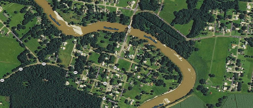
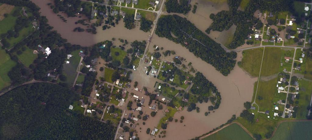
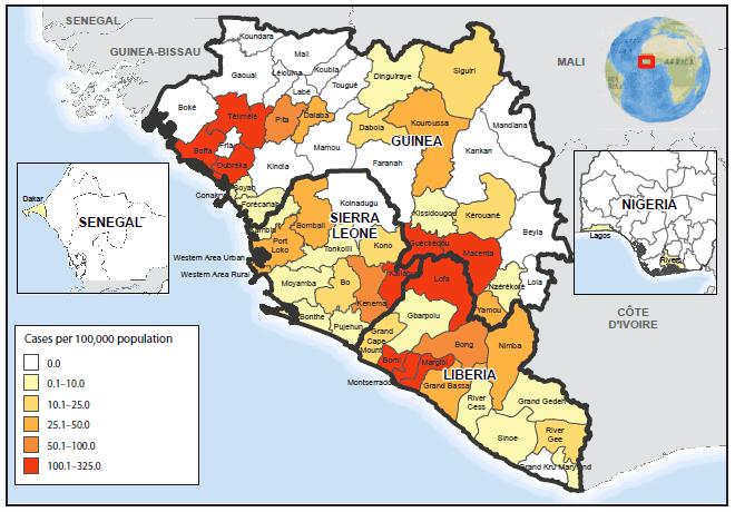


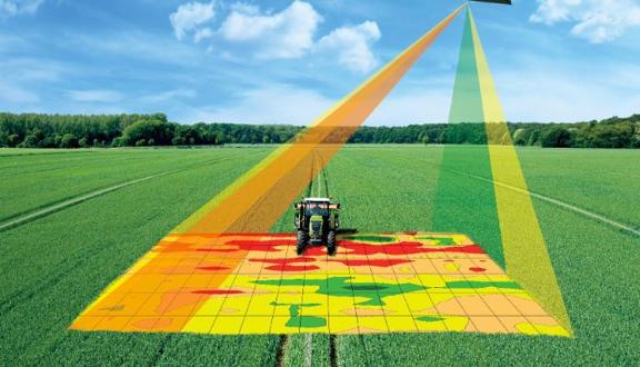
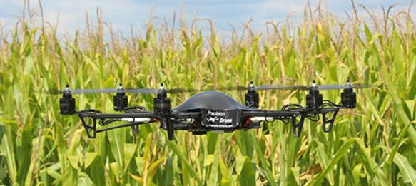
6 Spatial Big Data Analytics Applications sustainableamerica.org Location based services gps4us.com arcgis.com Disaster response (before and after flood) Precision agriculture cdc.gov innovationtoronto.com Image from the web Disease outbreak detection 6

7 Spatial Big Data Analytics: Challenges Volume Velocity Variety Value Huge dataset sizes High update rate Heterogeneous data Special challenges for spatial big data: source and types Autocorrelation: interdependency across nearby locations Anisotropy: dependency varying across directions Heterogeneity: similar feature different classes Scales: multiple resolutions; local, regional, global scales Addressing societal issues 7
 Aerial photo (R,G,B) in summer (c) Ground truth wetland")


8 Spatial Big Data Analytics: Challenges (a) Aerial photo (NIR,G,B) in spring (b) Aerial photo (R,G,B) in summer (c) Ground truth wetland map (d) Decision tree prediction Wetland Dry land Need novel spatial models, e.g., spatial decision trees o Salt-and-pepper noise in decision tree prediction o Require labor intensive pre/post-processing o General issue for many models: random forest, SVM, neural network. 8


9 Spatial Data Scientist sparsity distribution high dimension patient symptoms doctor appropriate treatment A specialized doctor, e.g., Cardiologist Images in this slide are from the web noise data characteristics data scientist data mining methods Spatial data scientist? 9
10 Process of Spatial Big Data Analytics domain expert interpretation Input data Preprocessing, Exploratory data analysis Spatial Data Mining Output patterns Spatial statistics Computational infrastructure 10
11 Technical View of Spatial Big Data Spatial statistics Machine Learning Spatial Data Mining Pattern Recognition SBD Spatial database Geographic Information System Hadoop, Spark, GPU Data analytics (effectiveness) Question: what are the differences between statistics, machine learning and data mining? Domain Knowledge Understand the problem Interpret results E.g., biology, agriculture Data models and management, computational efficiency The main focus of this course is spatial data analytics! 11
12 Prerequisite Database Algorithm Basic statistic and probability Programming skills Additional data mining or machine learning background is preferred 12
13 Topics Covered in This Course Spatial data models Spatial statistics Spatial big data analytics tasks Spatial big data platforms Recent trends 13


14 Topics Covered in This Course Spatial data models Field model Google map Object model Mississippi River Spatial reference system Des Moines River Spatial operations 14


 dnainfo.")
15 Topics Covered in This Course Spatial data models Spatial statistics ( source Visualeconomics ) Areal data model Geostatistics, e.g., Kriging (arcgis.com) dnainfo.com Spatial point process (shooting in Chicago) 15


16 Topics Covered in This Course Spatial data models Spatial statistics Spatial big data analytics tasks Spatial prediction Colocation Spatial outliers Spatial hotspot Spatial summarization Spatial change Spatial outliers Wetland mapping Colocation patterns Crime hotspot 16 Trajectory summarization


17 Topics Covered in This Course Spatial data models Spatial statistics Spatial big data analytics tasks Spatial big data platforms Recent trends 17
18 Topics Covered in This Course Spatial data models Spatial statistics Spatial big data analytics tasks Spatial big data platforms Recent trends 18
19 Course Website and Course website: Data/ Class schedule, notes, homework, announcement, etc. Course Homework submission, questions Please put CS491/591: Spatial Big Data in title 19
20 Assignments Four question-and-answer homework One course project (see next slide) One news presentation 5 minutes at the beginning of each lecture Topic related to geospatial (big) data analytic Notes: All assignments are done in teams of two. Find a partner Due by the beginning of the first lecture in each week 20
21 Course Project Topic Real world spatial (big) data analytic problem Students are welcome to bring their own topics We provide some candidate topics Discuss with the instructor in office hours to decide topics Progress management Project assignments (deliverables) Decide project topic and datasets Literature survey (data preprocessing) Proposed approach (implementation) Experimental evaluation Final report (w/ source codes, dataset) Midterm project presentation Final project presentation Come to my office hours often for feedback and guidance! 21
22 Exams One close-book midterm exam (Possibly one close-book final exam) Some questions will be different between CS 491 and CS
23 Grading Policy News presentation: 5% Question and answer assignment: 30% Project assignments: 40% (or 35% if two exams) Exams: 25% (or 30% if two exams) 23
24 Homework 0 Due Next Week A background survey Not graded 24
25 Questions? Introduce yourself to other people, and team up! 25
Spatial Decision Tree: A Novel Approach to Land-Cover Classification
 Spatial Decision Tree: A Novel Approach to Land-Cover Classification Zhe Jiang 1, Shashi Shekhar 1, Xun Zhou 1, Joseph Knight 2, Jennifer Corcoran 2 1 Department of Computer Science & Engineering 2 Department
ENVIRONMENT AND NATURAL RESOURCES 3700 Introduction to Spatial Information for Environment and Natural Resources. (2 Credit Hours) Semester Syllabus
 Semester Syllabus") ENVIRONMENT AND NATURAL RESOURCES 3700 Introduction to Spatial Information for Environment and Natural Resources COURSE INSTRUCTOR: Dr. Kris Jaeger Assistant Professor 359 Kottman Hall (Mondays and Tuesdays)
ENVIRONMENT AND NATURAL RESOURCES 3700 Introduction to Spatial Information for Environment and Natural Resources COURSE INSTRUCTOR: Dr. Kris Jaeger Assistant Professor 359 Kottman Hall (Mondays and Tuesdays)
Spatial Data Science. Soumya K Ghosh
 Workshop on Data Science and Machine Learning (DSML 17) ISI Kolkata, March 28-31, 2017 Spatial Data Science Soumya K Ghosh Professor Department of Computer Science and Engineering Indian Institute of Technology,
geographic patterns and processes are captured and represented using computer technologies
 Proposed Certificate in Geographic Information Science Department of Geographical and Sustainability Sciences Submitted: November 9, 2016 Geographic information systems (GIS) capture the complex spatial
CAS GE 365 Introduction to Geographical Information Systems. The Applications of GIS are endless
 Spring 2007 CAS GE 365 Introduction to Geographical Information Systems Boston University Department of Geography and Environment The Applications of GIS are endless images from www.esri.com CAS GE 365
Introduction to GIS (GEOG 401) Spring 2014, 3 credit hours
 Spring 2014, 3 credit hours") Introduction to GIS (GEOG 401) Spring 2014, 3 credit hours Instructors: Guangxing Wang, Ph.D. Email: gxwang@siu.edu Phone: (618) 453-6017 Office: 4442 Faner Hall Office hours: M& W&F 9:00am-11:00am or
Introduction to GIS (GEOG 401) Spring 2014, 3 credit hours Instructors: Guangxing Wang, Ph.D. Email: gxwang@siu.edu Phone: (618) 453-6017 Office: 4442 Faner Hall Office hours: M& W&F 9:00am-11:00am or
The Changing Landscape of Land Administration
 The Changing Landscape of Land Administration B r e n t J o n e s P E, PLS E s r i World s Largest Media Company No Journalists No Content Producers No Photographers World s Largest Hospitality Company
SYLLABUS SEFS 540 / ESRM 490 B Optimization Techniques for Natural Resources Spring 2017
 SYLLABUS SEFS 540 / ESRM 490 B Optimization Techniques for Natural Resources Spring 2017 Lectures: Winkenwerder Hall 107, 4:50-5:50pm, MW Labs: Mary Gates Hall 030, 1:30-2:50pm, Th Course Web Site: http://faculty.washington.edu/toths/course.shtml
GIST 4302/5302: Spatial Analysis and Modeling
 GIST 4302/5302: Spatial Analysis and Modeling Spring 2014 Lectures: Tuesdays & Thursdays 2:00pm-2:50pm, Holden Hall 00038 Lab sessions: Tuesdays or Thursdays 3:00pm-4:50pm or Wednesday 1:00pm-2:50pm, Holden
Esri and GIS Education
 Esri and GIS Education Organizations Esri Users 1,200 National Government Agencies 11,500 States & Regional Agencies 30,800 Cities & Local Governments 32,000 Businesses 8,500 Utilities 12,600 NGOs 11,000
IV Course Spring 14. Graduate Course. May 4th, Big Spatiotemporal Data Analytics & Visualization
 Spatiotemporal Data Visualization IV Course Spring 14 Graduate Course of UCAS May 4th, 2014 Outline What is spatiotemporal data? How to analyze spatiotemporal data? How to visualize spatiotemporal data?
Spatial Analysis and Modeling (GIST 4302/5302) Guofeng Cao Department of Geosciences Texas Tech University
 Guofeng Cao Department of Geosciences Texas Tech University") Spatial Analysis and Modeling (GIST 4302/5302) Guofeng Cao Department of Geosciences Texas Tech University TTU Graduate Certificate Geographic Information Science and Technology (GIST) 3 Core Courses and
Spatial Analysis and Modeling (GIST 4302/5302) Guofeng Cao Department of Geosciences Texas Tech University TTU Graduate Certificate Geographic Information Science and Technology (GIST) 3 Core Courses and
Geography 1103: Spatial Thinking
 Geography 1103: Spatial Thinking Lecture: T\TH 8:00-9:15 am (McEniry 401) Lab: Wed 2:00-4:30 pm (McEniry 420) Instructor: Dr. Elizabeth C. Delmelle Email: edelmell@uncc.edu Office: McEniry 419 Phone: 704-687-5932
Techniques for Science Teachers: Using GIS in Science Classrooms.
 Techniques for Science Teachers: Using GIS in Science Classrooms. After ESRI, 2008 GIS A Geographic Information System A collection of computer hardware, software, and geographic data used together for
CE 200 Surveying Fall 2017
 Department of Civil and Environmental Engineering CE 200 Surveying Fall 2017 Instructor: Dr. Laramie Potts Contact: email lpotts@njit.edu Office Hours in 2510 GITC: Monday 4:00 5:30 pm Classroom: CULM
https://u.osu.edu/miller.81/ Texts 1. Required Worboys, M. and Duckham, M. (2004) GIS: A Computing Perspective. Other readings see course schedule.
 GIS: A Computing Perspective. Other readings see course schedule.") GEOGR 5212 Geospatial Databases for GIS - Spring Instructor Harvey J. Miller Lecture/lab meeting time Tuesdays 3:55PM - 5:15PM, Denney Hall 238 and location (classroom) Thursdays 3:55PM - 5:15PM Derby
GEOGR 5212 Geospatial Databases for GIS - Spring Instructor Harvey J. Miller Lecture/lab meeting time Tuesdays 3:55PM - 5:15PM, Denney Hall 238 and location (classroom) Thursdays 3:55PM - 5:15PM Derby
GIST 4302/5302: Spatial Analysis and Modeling
 GIST 4302/5302: Spatial Analysis and Modeling Spring 2016 Lectures: Tuesdays & Thursdays 12:30pm-1:20pm, Science 234 Labs: GIST 4302: Monday 1:00-2:50pm or Tuesday 2:00-3:50pm GIST 5302: Wednesday 2:00-3:50pm
Welcome to Physics 161 Elements of Physics Fall 2018, Sept 4. Wim Kloet
 Welcome to Physics 161 Elements of Physics Fall 2018, Sept 4 Wim Kloet 1 Lecture 1 TOPICS Administration - course web page - contact details Course materials - text book - iclicker - syllabus Course Components
Geography (GEOG) Introduction to Geography Global Change and Natural Disasters and Environmental Change
 Introduction to Geography Global Change and Natural Disasters and Environmental Change") Geography (GEOG) Head of Department: Professor Jeffrey P. Osleeb Department Office: Room 422, Philip E. Austin Building For major requirements, see the College of Liberal Arts and Sciences section of this
Geography (GEOG) Head of Department: Professor Jeffrey P. Osleeb Department Office: Room 422, Philip E. Austin Building For major requirements, see the College of Liberal Arts and Sciences section of this
CS 6375 Machine Learning
 CS 6375 Machine Learning Nicholas Ruozzi University of Texas at Dallas Slides adapted from David Sontag and Vibhav Gogate Course Info. Instructor: Nicholas Ruozzi Office: ECSS 3.409 Office hours: Tues.
GIS FOR PLANNING. Course Overview. Schedule. Instructor. Prerequisites. Urban Planning 792 Thursday s 5:30-8:10pm SARUP 158
 GIS FOR PLANNING Urban Planning 792 Thursday s 5:30-8:10pm SARUP 158 Schedule Class/Lab - SARUP 158 Thursdays 5:30pm - 8:10pm Office Hours - By Appointment Project Ideas - Week 4 Final - 5/10/2018 Instructor
PHYS 480/580 Introduction to Plasma Physics Fall 2017
 PHYS 480/580 Introduction to Plasma Physics Fall 2017 Instructor: Prof. Stephen Bradshaw (302 Herman Brown Hall, ext. 4045) Email: stephen.bradshaw {at} rice.edu Class Website: Owl Space Lectures: Tuesday
MATH 251 Ordinary and Partial Differential Equations Summer Semester 2017 Syllabus
 MATH 251 Ordinary and Partial Differential Equations Summer Semester 2017 Syllabus Course Description: Ordinary and Partial Differential Equations. First and second order equations; series solutions; Laplace
(Spatial) Big Data Debates: Infrastructure, Analytics & Science
 Big Data Debates: Infrastructure, Analytics & Science") (Spatial) Big Data Debates: Infrastructure, Analytics & Science OSU/IPR Workshop on Big Data and Demography May 9 th, 2013. Shashi Shekhar McKnight Distinguished University Professor Department of Computer
(Spatial) Big Data Debates: Infrastructure, Analytics & Science OSU/IPR Workshop on Big Data and Demography May 9 th, 2013. Shashi Shekhar McKnight Distinguished University Professor Department of Computer
Machine Learning CSE546
 http://www.cs.washington.edu/education/courses/cse546/17au/ Machine Learning CSE546 Kevin Jamieson University of Washington September 28, 2017 1 You may also like ML uses past data to make personalized
Department of Civil and Environmental Engineering. CE Surveying
 Department of Civil and Environmental Engineering CE 200 - Surveying Instructor: Dr. Laramie Potts Contact: email lpotts@njit.edu Office Hours in 2510 GITC: Wednesday 10:00 12:00 pm Classroom: CULM LEC
GIST 4302/5302: Spatial Analysis and Modeling
 GIST 4302/5302: Spatial Analysis and Modeling Fall 2015 Lectures: Tuesdays & Thursdays 2:00pm-2:50pm, Science 234 Lab sessions: Tuesdays or Thursdays 3:00pm-4:50pm or Friday 9:00am-10:50am, Holden 204
https://sites.google.com/a/pdx.edu/gis-2-applications/home
 Page 1 of 5 GIS 2: APPLICATIONS Search this site GEOG 492/592: GIS 2 Syllabus Academic Guidelines Rubrics Presentation Rubric Project Poster Project Proposal Syllabus (PDF) Sitemap GEOG 492/592: GIS 2
Geo Business Gis In The Digital Organization
 We have made it easy for you to find a PDF Ebooks without any digging. And by having access to our ebooks online or by storing it on your computer, you have convenient answers with geo business gis in
Midterm: CS 6375 Spring 2015 Solutions
 Midterm: CS 6375 Spring 2015 Solutions The exam is closed book. You are allowed a one-page cheat sheet. Answer the questions in the spaces provided on the question sheets. If you run out of room for an
Your web browser (Safari 7) is out of date. For more security, comfort and. the best experience on this site: Update your browser Ignore
 is out of date. For more security, comfort and. the best experience on this site: Update your browser Ignore") Your web browser (Safari 7) is out of date. For more security, comfort and Activityengage the best experience on this site: Update your browser Ignore Introduction to GIS What is a geographic information
Your web browser (Safari 7) is out of date. For more security, comfort and Activityengage the best experience on this site: Update your browser Ignore Introduction to GIS What is a geographic information
Welcome. C o n n e c t i n g
 Welcome C o n n e c t i n g YOU D i s c i p l i n e s Why is This Meeting......So Important Now? OUR WORLD Is Increasingly Challenged The Evidence Is Clear We Need Better Understanding and More Collaboration
School of Public Service and Health EDMG240 Chemistry of Hazardous Materials 3 Credit Hours 8 weeks Prerequisite(s): None
: None") School of Public Service and Health EDMG240 Chemistry of Hazardous Materials 3 Credit Hours 8 weeks Prerequisite(s): None Instructor Information Course Description Course Scope Course Objectives Course
School of Public Service and Health EDMG240 Chemistry of Hazardous Materials 3 Credit Hours 8 weeks Prerequisite(s): None Instructor Information Course Description Course Scope Course Objectives Course
Introduction. Elevation Data Strategy. Status and Next Steps
 1 2 Introduction Elevation Data Strategy Status and Next Steps 3 Canada is the 2nd largest country in the world - 9.9 million sq km Surrounded by 3 oceans with 202 000 km of coastline Population over 35
DANIEL WILSON AND BEN CONKLIN. Integrating AI with Foundation Intelligence for Actionable Intelligence
 DANIEL WILSON AND BEN CONKLIN Integrating AI with Foundation Intelligence for Actionable Intelligence INTEGRATING AI WITH FOUNDATION INTELLIGENCE FOR ACTIONABLE INTELLIGENCE in an arms race for artificial
Statewide Topographic Mapping Program
 Statewide Topographic Mapping Program February 28, 2018 www.dotd.la.gov Outline Purpose of the Statewide Topographic Mapping Program History Breakdown of R.S. 48:36 - Topographic Mapping Statewide Topographic
Advancing Machine Learning and AI with Geography and GIS. Robert Kircher
 Advancing Machine Learning and AI with Geography and GIS Robert Kircher rkircher@esri.com Welcome & Thanks GIS is expected to do more, faster. see where find where predict where locate, connect WHERE route
XXIII CONGRESS OF ISPRS RESOLUTIONS
 XXIII CONGRESS OF ISPRS RESOLUTIONS General Resolutions Resolution 0: Thanks to the Czech Society commends: To congratulate The Czech Society, its president and the Congress Director Lena Halounová, the
Machine Learning (CS 567) Lecture 2
 Lecture 2") Machine Learning (CS 567) Lecture 2 Time: T-Th 5:00pm - 6:20pm Location: GFS118 Instructor: Sofus A. Macskassy (macskass@usc.edu) Office: SAL 216 Office hours: by appointment Teaching assistant: Cheol
Machine Learning (CS 567) Lecture 2 Time: T-Th 5:00pm - 6:20pm Location: GFS118 Instructor: Sofus A. Macskassy (macskass@usc.edu) Office: SAL 216 Office hours: by appointment Teaching assistant: Cheol
Geo-Enabling Mountain Bike Trail Maintenance:
 Title Slide Geo-Enabling Mountain Bike Trail Maintenance: Enhanced Stewardship of the Fountainhead Mountain Bike Trail through GIS Technology Ruthann Ligon Follow the Trail Fountainhead Mountain Bike
Health and Medical Geography (GEOG 222)
") Spring 2019 Class meets: Tuesdays and Thursdays 12:30-1:45pm Carolina Hall Room 220 Instructor: Michael Emch Email: emch@unc.edu Course Objectives Health and Medical Geography (GEOG 222) This course is
Spring 2019 Class meets: Tuesdays and Thursdays 12:30-1:45pm Carolina Hall Room 220 Instructor: Michael Emch Email: emch@unc.edu Course Objectives Health and Medical Geography (GEOG 222) This course is
Introduction to Geographic Information Systems
 Geog 58 Introduction to Geographic Information Systems, Fall, 2003 Page 1/8 Geography 58 Introduction to Geographic Information Systems Instructor: Lecture Hours: Lab Hours: X-period: Office Hours: Classroom:
Key Points Sharing fosters participation and collaboration Metadata has a big role in sharing Sharing is not always easy
 Sharing Resources Geoff Mortson esri, Inc. SDI Solutions Team Key Points Sharing fosters participation and collaboration Metadata has a big role in sharing Sharing is not always easy Data Sharing is Good
Syllabus Reminders. Geographic Information Systems. Components of GIS. Lecture 1 Outline. Lecture 1 Introduction to Geographic Information Systems
 Syllabus Reminders Geographic Information s Lecture Introduction to Geographic Information s. Class Info: www.saigis.com/class/ 2. Office T / TH (8:00-9:30 a.m.) and (2:30 3:30pm) or Appt 3. Email: burgerpr@unk.edu
1.1 Administrative Stuff
 601.433 / 601.633 Introduction to Algorithms Lecturer: Michael Dinitz Topic: Introduction, Karatsuba/Strassen Date: 9/4/18 1.1 Administrative Stuff Welcome to Algorithms! In this class you will learn the
Office Hours: Dr. Kruse: Tue, 14:30-15:30 & Fri, 10:30-11:30 in ABB 142 (Chemistry Help Centre) TA's: tutorial time
 TA's: tutorial time") Chem 2P03 & ChemBio 2P03 Course Outline - Fall 2016 Applications of Physical Chemistry Prof. P. Kruse, ABB-263, x23480, pkruse@mcmaster.ca http://www.chemistry.mcmaster.ca/kruse/ version 16 August 2016
Chem 2P03 & ChemBio 2P03 Course Outline - Fall 2016 Applications of Physical Chemistry Prof. P. Kruse, ABB-263, x23480, pkruse@mcmaster.ca http://www.chemistry.mcmaster.ca/kruse/ version 16 August 2016
AE 200 Engineering Analysis and Control of Aerospace Systems
 Instructor Info Credit Class Days / Time Office Location: ENG 272C Office Hours: Monday 4:00pm 6:30pm Email: kamran.turkoglu@sjsu.edu 3 units Tuesday, 6:00pm 8:45pm Classroom CL 222 Prerequisites TA: Contact
MOLECULAR MODELING IN BIOLOGY (BIO 3356) SYLLABUS
 SYLLABUS") New York City College of Technology School of Arts and Sciences Department of Biological Sciences MOLECULAR MODELING IN BIOLOGY (BIO 3356) SYLLABUS Course Information Course Title: Molecular Modeling in
New York City College of Technology School of Arts and Sciences Department of Biological Sciences MOLECULAR MODELING IN BIOLOGY (BIO 3356) SYLLABUS Course Information Course Title: Molecular Modeling in
8/28/2011. Contents. Lecture 1: Introduction to GIS. Dr. Bo Wu Learning Outcomes. Map A Geographic Language.
 Contents Lecture 1: Introduction to GIS Dr. Bo Wu lsbowu@polyu.edu.hk Department of Land Surveying & Geo-Informatics The Hong Kong Polytechnic University 1. Learning outcomes 2. GIS definition 3. GIS examples
Part : General Situation of Surveying and Mapping. The Development of Surveying and Mapping in China. The contents
 The Development of Surveying and Mapping in China Dr. Ping Xiao China.P.R The contents Part : General Situation of Surveying and Mapping 1. The legal systems of surveying and mapping 2. The technologies
Spatial Data, Spatial Analysis and Spatial Data Science
 Spatial Data, Spatial Analysis and Spatial Data Science Luc Anselin http://spatial.uchicago.edu 1 spatial thinking in the social sciences spatial analysis spatial data science spatial data types and research
CHEM 333 Spring 2016 Organic Chemistry I California State University Northridge
 CHEM 333 Spring 2016 Organic Chemistry I California State University Northridge Lecture: Instructor: Thomas Minehan Office: Science 2314 Office hours: MW 12:00-1:00 pm E.mail: thomas.minehan@csun.edu Class
EOS-310 Severe & Unusual Weather Spring, 2009 Associate Prof. Zafer Boybeyi 1/20/09
 EOS-310 Spring, 2009 Associate Prof. Zafer Boybeyi 1/20/09 1 Instructor and Contact information Associate Prof. Zafer Boybeyi Research I, Room 217 Mail Stop 6A2 Email: zboybeyi@gmu.edu Phone: (703) 993-1560
Geography for the 2020 Round of Census
 Boundaries Key Census Data EA Id Population Male Female EA Id Area EA Id Num HH Avg HH size Geography for the 2020 Round of Census Linda Peters, Esri lpeters@esri.com Integration of Statistical and Geospatial
Regional Centre for Mapping of Resources for Development (RCMRD), Nairobi, Kenya
, Nairobi, Kenya") Regional Centre for Mapping of Resources for Development (RCMRD), Nairobi, Kenya Introduction to GIS (2 weeks: 10 days) Intakes: 8 th January, 6 th February, 5th March, 3 rd. April 9 th, May 7 th, June
Regional Centre for Mapping of Resources for Development (RCMRD), Nairobi, Kenya Introduction to GIS (2 weeks: 10 days) Intakes: 8 th January, 6 th February, 5th March, 3 rd. April 9 th, May 7 th, June
GEOG 410: SPATIAL ANALYSIS SPRING 2016
 GEOG 410: SPATIAL ANALYSIS SPRING 2016 Instructor: Christopher Bone Lectures: 2 x 1-hour lectures/week Labs: 1 x 2-hour lecture/week TEXTBOOKS McGrew Jr, J. C., & Monroe, C. B. (2000). An Introduction
GEOMATICS. Shaping our world. A company of
 GEOMATICS Shaping our world A company of OUR EXPERTISE Geomatics Geomatics plays a mayor role in hydropower, land and water resources, urban development, transport & mobility, renewable energy, and infrastructure
No. of Days. Building 3D cities Using Esri City Engine ,859. Creating & Analyzing Surfaces Using ArcGIS Spatial Analyst 1 7 3,139
 Q3 What s New? Creating and Editing Data with ArcGIS Pro Editing and Maintaining Parcels Using ArcGIS Spatial Analysis Using ArcGIS Pro User Workflows for ArcGIS Online Organizations Q3-2018 ArcGIS Desktop
Regional Centre for Mapping of Resources for Development (RCMRD), Nairobi, Kenya
, Nairobi, Kenya") Regional Centre for Mapping of Resources for Development (RCMRD), Nairobi, Kenya Introduction GIS ( 2 weeks: 10 days) Intakes: 7 th Jan, 4 th Feb,4 th March, 1 st April 6 th May, 3 rd June, 1 st July,
Regional Centre for Mapping of Resources for Development (RCMRD), Nairobi, Kenya Introduction GIS ( 2 weeks: 10 days) Intakes: 7 th Jan, 4 th Feb,4 th March, 1 st April 6 th May, 3 rd June, 1 st July,
COURSE INTRODUCTION & COURSE OVERVIEW
 week 1 COURSE INTRODUCTION & COURSE OVERVIEW topics of the week Instructor introduction Students introductions Course logistics Course objectives Definition of GIS The story of GIS introductions Who am
University of Houston-Clear Lake PHYS Modern Physics (Summer 2015) Syllabus 3:00-5:50pm Bayou 3324
 Syllabus 3:00-5:50pm Bayou 3324") University of Houston-Clear Lake PHYS 3303-01 Modern Physics (Summer 2015) Syllabus 3:00-5:50pm (TWR) @ Bayou 3324 Quality Enhancement Plan (QEP) Applied Critical Thinking for Lifelong Learning and Adaptability
University of Houston-Clear Lake PHYS 3303-01 Modern Physics (Summer 2015) Syllabus 3:00-5:50pm (TWR) @ Bayou 3324 Quality Enhancement Plan (QEP) Applied Critical Thinking for Lifelong Learning and Adaptability
My Map Activity MINNESOTA SOCIAL STUDIES STANDARDS & BENCHMARKS
 My Map Activity OVERVIEW & OBJECTIVES Students will learn the basics of Google Maps while using geospatial data to create their neighborhood map with the places they spend time. They will also collect
Dr. Stephen J. Walsh Department of Geography, UNC-CH Fall, 2007 Monday 3:30-6:00 pm Saunders Hall Room 220. Introduction
 Geographic Information Systems Geography 491 Dr. Stephen J. Walsh Department of Geography, UNC-CH Fall, 2007 Monday 3:30-6:00 pm Saunders Hall Room 220 Introduction Organizations that have a planning,
PHYS100 General Physics - Mechanics and Thermodynamics Fall
 PHYS100 General Physics - Mechanics and Thermodynamics Fall 2014-2015 Assoc. Prof. Dr. O. Özgür Eğilmez Civil Engineering Department Room: A-523 Email: ozgur.egilmez@ieu.edu.tr Phone: (232) 488-8214 Textbook:
Integrating Globus into a Science Gateway for Cryo-EM
 Integrating Globus into a Science Gateway for Cryo-EM Michael Cianfrocco Life Sciences Institute Department of Biological Chemistry University of Michigan Globus World 2018 Impact & growth of Executive
Lesson Plan 3 Google Earth Tutorial on Land Use for Middle and High School
 An Introduction to Land Use and Land Cover This lesson plan builds on the lesson plan on Understanding Land Use and Land Cover Using Google Earth. Please refer to it in terms of definitions on land use
Don t Trust Atoms, they Make Up Everything High School Chemistry
 Don t Trust Atoms, they Make Up Everything High School Chemistry Grades: 9 th 12 th Day of Week: Thursday Time of Class: 1:00 pm 2:30 pm EST Length of Class: 30 weeks Semester: Fall 2019, Winter 2020,
Compact guides GISCO. Geographic information system of the Commission
 Compact guides GISCO Geographic information system of the Commission What is GISCO? GISCO, the Geographic Information System of the COmmission, is a permanent service of Eurostat that fulfils the requirements
UPDATING THE MINNESOTA NATIONAL WETLAND INVENTORY
 UPDATING THE MINNESOTA NATIONAL WETLAND INVENTORY An Integrated Approach Using Object-Oriented Image Analysis, Human Air-Photo Interpretation and Machine Learning AARON SMITH EQUINOX ANALYTICS INC. FUNDING
An Introduction to Using Geographic Information Systems (GIS) in the Classroom
 in the Classroom") Georgia Southern University Digital Commons@Georgia Southern Interdisciplinary STEM Teaching & Learning Conference Mar 24th, 10:00 AM - 11:30 AM An Introduction to Using Geographic Information Systems
Georgia Southern University Digital Commons@Georgia Southern Interdisciplinary STEM Teaching & Learning Conference Mar 24th, 10:00 AM - 11:30 AM An Introduction to Using Geographic Information Systems
Regional Centre for Mapping of Resources for Development (RCMRD), Nairobi, Kenya. Introduction GIS ( 2 weeks: 10 days)
, Nairobi, Kenya. Introduction GIS ( 2 weeks: 10 days)") Regional Centre for Mapping of Resources for Development (RCMRD), Nairobi, Kenya Introduction GIS ( 2 weeks: 10 days) Intakes: 8 th Jan, 6 th Feb,5 th March, 3 rd April 9 th, May 7 th, June 4 th, July
Regional Centre for Mapping of Resources for Development (RCMRD), Nairobi, Kenya Introduction GIS ( 2 weeks: 10 days) Intakes: 8 th Jan, 6 th Feb,5 th March, 3 rd April 9 th, May 7 th, June 4 th, July
PHYSICS 206, Spring 2019
 PHYSICS 206, Spring 2019 Instructor: Gregory Christian Lecture times: TR 9:35 10:50, room MPHY 203 Office: MIST M320 Phone: 979-845-1411 Email: gchristian@tamu.edu Homepage: http://faculty.physics.tamu.edu/christian/teaching.html
Science : Introduction to Astronomy Course Syllabus
 Science 3210 001: Introduction to Astronomy Course Syllabus Instructor : Dr. Robert Fisher Spring, 2008 OFFICE HOURS : By Appointment OFFICE PHONE : 773-834-3506 (University of Chicago), 708-574-5368 (cell)
GIS certificate; 24th 28th September and 3rd 7th December University of Venda
 ;, TARGET Delegates; Town planners. Geologist, Hydrologist, Hydro-Geologists Botanists Conservationists Land Surveyors, Educators, Researchers, Undergraduate and post-graduate students, companies, Local
CCHEMISTRY 366. Inorganic Chemistry with Emphasis on Bioinorganic, Medicinal & Materials Chemistry
 CCHEMISTRY 366 Inorganic Chemistry with Emphasis on Bioinorganic, Medicinal & Materials Chemistry Instructor: North Building Office Hours: to be decided by class, probably Tuesday after class or by appointment.
Today s Menu. Administrativia Two Problems Cutting a Pizza Lighting Rooms
 Welcome! L01 Today s Menu Administrativia Two Problems Cutting a Pizza Lighting Rooms Administrativia Course page: https://www.cs.duke.edu/courses/spring13/compsci230/ Who we are: Instructor: TA: UTAs:
HGP 470 GIS and Advanced Cartography in Social Science
 HGP 470 GIS and Advanced Cartography in Social Science Fall 2012 Instructor: Dr Sinisa J. Vukicevic Office: Tory 3-115 Telephone: 780-248-5758 E-mail: vukicevi@ualberta.ca Office hours: Wednesday 10:00
CURRICULUM DESIGN FOR A UNIVERSITY GRADUATE COURSE ON ADVANCED TOPICS IN GIS FOR NATURAL RESOURCES MANAGEMENT
 CURRICULUM DESIGN FOR A UNIVERSITY GRADUATE COURSE ON ADVANCED TOPICS IN GIS FOR NATURAL RESOURCES MANAGEMENT Yousif Ali Hussin Department of Natural Resources, International Institute for Geoinformation
Anoka Hennepin K 12 Curriculum Unit Plan
 Anoka Hennepin K 12 Curriculum Unit Plan Department: Social Studies Grade Level: 4 Unit Title: Geographic Investigations Trimester: 2 and 3 (16) 55 minute lessons (can be (32) 25 minute lessons) Unit Summary:
MATH-3150H-A: Partial Differential Equation 2018WI - Peterborough Campus
 MATH-3150H-A: Partial Differential Equation 2018WI - Peterborough Campus Instructor: Instructor: Kenzu Abdella Email Address: kabdella@trentu.ca Phone Number: 705-748-1011 x7327 Office: GSC 339 Office
Course Staff. Textbook
 Course Staff CS311H: Discrete Mathematics Intro and Propositional Logic Instructor: Işıl Dillig Instructor: Prof. Işıl Dillig TAs: Jacob Van Geffen, Varun Adiga, Akshay Gupta Class meets every Monday,
Petrology Spring Please grab a syllabus. Introductions
 Petrology Spring 2012 Please grab a syllabus Introductions Instructor: Dr Jasper Konter Office: GEOL 404a Office hours: TBA, or by appointment Phone: x5507 Email: jgkonter@utep.edu * *Note: Email is the
COURSE OUTLINE GEOL204 MINING COMPUTING 3 CREDITS
 COURSE OUTLINE GEOL204 MINING COMPUTING 3 CREDITS PREPARED BY: Joel Cubley, Instructor DATE: June 1, 2018 APPROVED BY: Margaret Dumkee, Dean DATE: June 1, 2018 APPROVED BY ACADEMIC COUNCIL: May 2014 GEOL204
Regional Centre for Mapping of Resources for Development (RCMRD), Nairobi, Kenya. Introduction GIS (2 weeks: 10 days)
, Nairobi, Kenya. Introduction GIS (2 weeks: 10 days)") Regional Centre for Mapping of Resources for Development (RCMRD), Nairobi, Kenya Introduction GIS (: 10 days) Intake Dates: 9 th Jan, 6 th Feb, 6 th Mar, 3 rd April, 8 th May, 5 th June, 3 rd July, 2017
Regional Centre for Mapping of Resources for Development (RCMRD), Nairobi, Kenya Introduction GIS (: 10 days) Intake Dates: 9 th Jan, 6 th Feb, 6 th Mar, 3 rd April, 8 th May, 5 th June, 3 rd July, 2017
SYLLABUS FORM WESTCHESTER COMMUNITY COLLEGE Valhalla, NY lo CURRENT DATE: Please indicate whether this is a NEW COURSE or a REVISION:
 SYLLABUS FORM WESTCHESTER COMMUNITY COLLEGE Valhalla, NY lo595 l. Course #: 2. NAME OF ORIGINATOR /REVISOR: PHYSC 143 Laurel Senft, Rob Applebaum, Eryn Klosko NAME OF COURSE Earth Science 3. CURRENT DATE:
Physics 112 Spring 2014
 Physics 112 Spring 2014 Phys 112 (S12) Syllabus/introduction 1 Goals Deeper understanding of concepts: less mysterious Entropy Free energy Chemical potential Statistical mechanics fluctuations kinetic
MIDTERM: CS 6375 INSTRUCTOR: VIBHAV GOGATE October,
 MIDTERM: CS 6375 INSTRUCTOR: VIBHAV GOGATE October, 23 2013 The exam is closed book. You are allowed a one-page cheat sheet. Answer the questions in the spaces provided on the question sheets. If you run
Innovation and modernization of national statistical systems through trusted data collaboratives
 Innovation and modernization of national statistical systems through trusted data collaboratives Carlos Felipe Prada Deputy Director Bogotá, Colombia November 2017 www.dane.gov.co The Colombian National
REVIEW MAPWORK EXAM QUESTIONS 31 JULY 2014
 REVIEW MAPWORK EXAM QUESTIONS 31 JULY 2014 Lesson Description In this lesson we: Focus on key concepts and exam questions relating to GIS. Question 1 Test Yourself The most important component of a GIS
STEREO ANALYST FOR ERDAS IMAGINE Stereo Feature Collection for the GIS Professional
 STEREO ANALYST FOR ERDAS IMAGINE Stereo Feature Collection for the GIS Professional STEREO ANALYST FOR ERDAS IMAGINE Has Your GIS Gone Flat? Hexagon Geospatial takes three-dimensional geographic imaging
Integrating Official Statistics and Geospatial Information NBS Experience
 Integrating Official Statistics and Geospatial Information NBS Experience Presented by Eng. Reda AL Sabbagh Director of IT Dept. Prepared by Eng. Adham Makky GIS Specialist Topics to be covered: Background
GEOGRAPHIC INFORMATION SYSTEMS Session 8
 GEOGRAPHIC INFORMATION SYSTEMS Session 8 Introduction Geography underpins all activities associated with a census Census geography is essential to plan and manage fieldwork as well as to report results
Cartographic and Geospatial Futures
 Cartographic and Geospatial Futures 1. Web Cartography, WebGIS, & Virtual Globes--New Roles for Maps, GIS, and GIS professionals 2. Map Mashups, the Neo Neo-geography Movement, & Crowd-sourcing Geospatial
Disaster Management in Republic of Korea
 The Third UN-GGIM-AP Plenary Meeting Disaster Management in Republic of Korea ~Coordination among NGIA & Other Related Organizations and Recommendations~ Bali Indonesia 10 November 2014 Sanghoon Lee, Ph.D.
Commercialisation. Lessons learned from Dutch weather market
 Commercialisation Lessons learned from Dutch weather market Where information comes together weather traffic public transport Weather, traffic and public transport. Daily actual information that influences
GEOG 3340: Introduction to Human Geography Research
 GEOG 3340: Introduction to Human Geography Research Lecture 1: Course Overview Guofeng Cao www.myweb.ttu.edu/gucao Department of Geosciences Texas Tech University guofeng.cao@ttu.edu Fall 2015 Course Description
GEOG 508 GEOGRAPHIC INFORMATION SYSTEMS I KANSAS STATE UNIVERSITY DEPARTMENT OF GEOGRAPHY FALL SEMESTER, 2002
 GEOG 508 GEOGRAPHIC INFORMATION SYSTEMS I KANSAS STATE UNIVERSITY DEPARTMENT OF GEOGRAPHY FALL SEMESTER, 2002 Course Reference #: 13210 Meeting Time: TU 2:05pm - 3:20 pm Meeting Place: Ackert 221 Remote
USING GIS CARTOGRAPHIC MODELING TO ANALYSIS SPATIAL DISTRIBUTION OF LANDSLIDE SENSITIVE AREAS IN YANGMINGSHAN NATIONAL PARK, TAIWAN
 CO-145 USING GIS CARTOGRAPHIC MODELING TO ANALYSIS SPATIAL DISTRIBUTION OF LANDSLIDE SENSITIVE AREAS IN YANGMINGSHAN NATIONAL PARK, TAIWAN DING Y.C. Chinese Culture University., TAIPEI, TAIWAN, PROVINCE
ENV208/ENV508 Applied GIS. Week 1: What is GIS?
 ENV208/ENV508 Applied GIS Week 1: What is GIS? 1 WHAT IS GIS? A GIS integrates hardware, software, and data for capturing, managing, analyzing, and displaying all forms of geographically referenced information.