CASE STUDY: BIM AND GEOTECHNICAL PROJECT IN URBAN AREA INFINITY TOWER, LISBON, PORTUGAL
|
|
|
- Aubrey Welch
- 5 years ago
- Views:
Transcription


1 CASE STUDY: BIM AND GEOTECHNICAL PROJECT IN URBAN AREA INFINITY TOWER, LISBON, PORTUGAL Parallel Session 10 Underground Construction 14 th August 14:00-16:00 Room 03/28 João Gondar, JETsj Geotecnia Alexandre Pinto, JETsj Geotecnia Catarina Fartaria, JETsj Geotecnia CHINA-EUROPE CONFERENCE ON GEOTECHNICAL ENGINEERING VIENNA, AUSTRIA 2018

2 TABLE OF CONTENTS 1. Introduction 2. Infinity Tower Project 3. Proposed Earth Retaining Solution 4. Design Methodology 5. Final Remarks
3 1. INTRODUCTION


4 1. INTRODUCTION LOCATION WW Drainage Tunnel Site area 4.600m 2
5 TABLE OF CONTENTS 1. Introduction 2. Infinity Tower Project 3. Proposed Earth Retaining Solution 4. Design Methodology 5. Final Remarks
6 2. INFINITY TOWER PROJECT

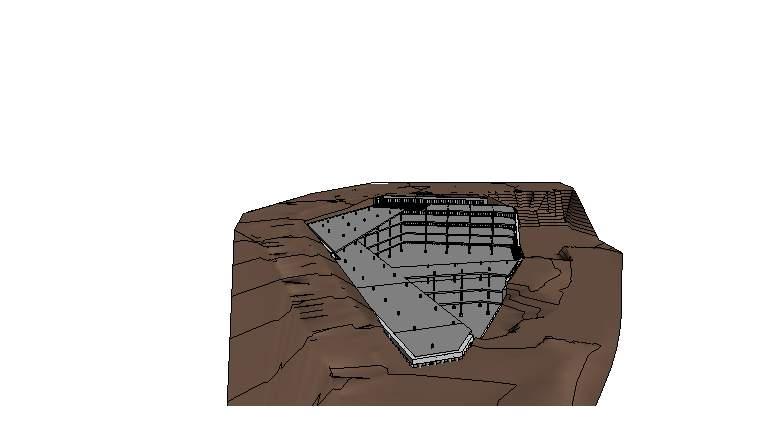
7

8

9 ARCHITECTURAL FEATURES The future tallest modern building of Lisbon will feature 26 floors and 4 basements. An iconic building in Lisbon s skyline with an impressive contemporary architecture.


10 GEOTECHNICAL FEATURES Heterogeneous Urban Fills. About 20m excavation depth intersecting Urban Fills and the Lisbon Volcanic Complex: mainly basalts and clay tuffs Lisbon Volcanic Complex: formed 72 million years ago by several important volcanic episodes, showing mainly basaltic sheets, volcanic tuffs, pyroclasts, volcanic breccias, etc,

11 Basalts Tuffs Landfills
12 TABLE OF CONTENTS 1. Introduction 2. Infinity Tower Project 3. Proposed Earth Retaining Solution 4. Design Methodology 5. Final Remarks
13 3. PROPOSED EARTH RETAINIG SOLUTION


14 MAIN RESTRAINTS Geotechnical and Geological: Landfills + Lisbon Volcanic Complex. Topographic: small hill. Surrounding Infrastructures: Alcantara WW Drainage Tunnel. Surrounding Infrastructures: Roads + Roadway Viaduct. Surrounding Infrastructures: Railway Line. WW Drainage Tunnel
15 GEOTECHNICAL AND GEOLOGICAL The ground characterization was made through 9 boreholes with SPT tests, continuous sampling collection for laboratory tests and piezometers. The area is covered by a landfill deposit layer, over the Lisbon Volcanic Complex (LVC). 4 main geotechnical Zones were established: ZG1, regarding the landfill layer; ZG2 for pyroclastic tuffs and low-quality basalts; ZG3 and ZG4 for medium to high-quality basalts.

16 GEOTECHNICAL AND GEOLOGICAL 9 boreholes location
17 GEOTECHNICAL ZONES - ZG Geotechnical Zone Description γ (kn/m 3 ) Ø (º) c (kpa) Es (MPa) ZG1 Landfill (5 NSPT 17) Pyroclastic tuffs and low-quality ZG2 ZG3 ZG4 basalts W4 to W3-4; F5 to F4-5 with recovery ranging from 60% e 100% e RQD=0% Basalts W3 to W3-2, F4 to F4-5, with 90% recovery ranging and 20% RQD 75%, interbedded with basalts W3-2, F4-5 with 100% recover and 47% RQD 74% Basalts W3-2 to F4-3, with 100% recovery and 56% RQD 76%

18 TOPOGRAPHY The existing topography, with the building location laying over a small hill, leads to an excavation depth ranging from 18m to 7m at the opposite alignments Railway line

19 MAIN RESTRAINTS Topography Railway Line + Roadway Viaduct Viaduct

20 MAIN RESTRAINTS Surrounding Infrastructures Alcantara Stream, 1912

21 MAIN RESTRAINTS Surrounding Infrastructures Alcantara Waste Water Drainage Tunnel, 1945
22 MAIN RESTRAINTS Surrounding Infrastructures Alcantara Waste Water Drainage Tunnel, close to excavation pit WW Drainage Tunnel Excavation pit
23 PROPOSED SOLUTION The solution was proposed considering the existing restraints, with the following purposes:
24 PROPOSED SOLUTION The solution was proposed considering the existing restraints, with the following purposes: Control the ground deformation; To minimize the interferences with the surrounding infrastructures and services; Improve Safety + Decrease Schedule + Decrease Costs.
25 PROPOSED SOLUTION The solution was proposed considering the existing restraints, with the following purposes: Control the ground deformation; To minimize the interferences with the surrounding infrastructures and services; Improve Safety + Decrease Schedule + Decrease Costs. Bored Pilled Wall solution with 600mm diameter pile and a plan space ranging between 0.80m and 1.20m. The total pile s depth ranges from 21.60m to 10.30m, all with a minimum embedment length of 4.00m.


26 PROPOSED SOLUTION The ground between the piles will be lined by a shotcrete layer of 150mm minimum thickness Geodrain pipes with 3m length will be installed with a minimum of 3.60m plan distance in order to ensure the ground drainage. Geodrain pipes 1,2m 1,2m Piles Ø0,60m Lining layer Solution plan Ventilation and drainage box
27 PROPOSED SOLUTION In the west view, the wall will be braced by one level of temporary ground anchors to be installed at level -2 with 3.60m plan space. The remaining excavation alignments will be stabilized with slab bands of 12m width and 0.35m minimum thickness, compatible with both the architecture and structural solutions.
28 PROPOSED SOLUTION The slab bands will be supported by vertical steel profiles HEB260 embed in 600mm bored piles, 4m below the excavation final level.

29 PROPOSED SOLUTION The slab bands will be supported by vertical steel profiles HEB260 embed in 600mm bored piles, 4.00m below the bottom level of excavation. The slab bands above level -2 will be supported by slimmer slab strips of aboute 7m width that will react against the piles wall at the west view.
30 TABLE OF CONTENTS 1. Introduction 2. Infinity Tower Project 3. Proposed Earth Retaining Solution 4. Design Methodology 5. Final Remarks
31 4. DESIGN METHODOLOGY


32 Preparation Topography Structure Analysis CHINA-EUROPE CONFERENCE ON GEOTECHNICAL ENGINEERING, VIENNA 2018 DESIGN METHODOLOGY Units Phasing Levels Earthworks quantities Restraints Bored Piles Slab bands RC beams Plaxis SAP2000 Geolocation Steel profiles Ground anchors
, Budget (5D), Sustainability and n D Models facility management (6D and 7D).")
 Interoperability Collaboration Promotes an early stage design team-up.")
33 DESIGN METHODOLOGY Information Centralized in the 3D objects. Information n D Models Time (4D), Budget (5D), Sustainability and n D Models facility management (6D and 7D). Interoperability BIM Capacity to seamlessly exchange information within different platforms. Level of Development (LoD) Interoperability Collaboration Promotes an early stage design team-up. Collaboration Level of Development Level of information associated with the objects.
34 DESIGN METHODOLOGY Among the elements received was the architecture project geometry in a 3D BIM model. The existing topography was modeled in the BIM software.

35 DESIGN METHODOLOGY Among the elements received was the architecture project geometry in a 3D BIM model. The existing topography was modeled in the BIM software. The architecture model was linked to the file and the geographic position of the surface was coordinated with the architecture model and the existing lot boundary and topography.


36 DESIGN METHODOLOGY The modeling of the bored piles wall was done according to the architecture 3D BIM model.
37 DESIGN METHODOLOGY

38 DESIGN METHODOLOGY The solution was evaluated using the geotechnical software (PLAXIS2D) Displacements and efforts were estimated and analyzed considering the geotechnical zones and correspondent parameters. Plaxis Output

39 SAP2000 MODEL IMPORTED FROM A 3D BIM FILE The geometry of the slabs were exported to a structural analysis software (SAP2000) using an IFC file type. Loads obtained from the PLAXIS2D were introduced on the SAP2000 model and the deformations compatibility was checked on a iterative way SAP2000 Model
40 TABLE OF CONTENTS 1. Introduction 2. Infinity Tower Project 3. Proposed Earth Retaining Solution 4. Design Methodology 5. Final Remarks
41 5. FINAL REMARKS
42 FINAL REMARKS The use of BIM methodology allowed an accurate coordination with the architecture and others engineering projects and promoted efficiency in terms of project documentation, especially when changes were needed. The interoperability among software allowed that the geometry from the 3D BIM model could be exported. The 3D visualization of the project and the restrains helped to find out the best engineering solutions, including the compatibility check between the several architecture and engineering solutions. The BIM model will be a very useful at both the construction and the building maintenance / management under operation phases


43 CHINA-EUROPE CONFERENCE ON GEOTECHNICAL ENGINEERING, VIENNA 2018 THE GROUND IS OUR CHALENGE THANK YOU FOR YOUR ATTENTION VIELEN DANK
Carlos Baião Cenorgeo DESIGN AND CONSTRUCTION OF THE MACHICO-CANIÇAL CANIÇAL EXPRESSWAY TUNNELS
 Carlos Baião Cenorgeo carlos.baiao@cenor.pt DESIGN AND CONSTRUCTION OF THE MACHICO-CANIÇAL CANIÇAL EXPRESSWAY TUNNELS PRESENTATION LAYOUT Overall considerations Geological conditions Geological-geotechnical
Engineer. Engineering. Engineering. (in-ja-neer ) A person trained and skilled in any of the various branches of engineering: a civil engineer
 A person trained and skilled in any of the various branches of engineering: a civil engineer") Engineer (in-ja-neer ) A person trained and skilled in any of the various branches of engineering: a civil engineer (Random House Webster s College Dictionary, 1991) CE100 Introduction to Civil Geotechnical
Engineer (in-ja-neer ) A person trained and skilled in any of the various branches of engineering: a civil engineer (Random House Webster s College Dictionary, 1991) CE100 Introduction to Civil Geotechnical
SITE INVESTIGATION 1
 SITE INVESTIGATION 1 Definition The process of determining the layers of natural soil deposits that will underlie a proposed structure and their physical properties is generally referred to as site investigation.
Talić Z. et al: Geotechnical characteristics... Archives for Technical Sciences 2014, 11(1), 33-39
, 33-39") Review paper UDC: 624.131.537 DOI: 10.7251/afts.2014.0611.033T COBISS.RS-ID 4572184 GEOTECHNICAL CHARACTERISTICS OF THE TERRAIN AND CALCULATION OF BEARING CAPACITY FOR BRIDGE No. 1 OF MOTORWAY LAŠVA DONJI
Review paper UDC: 624.131.537 DOI: 10.7251/afts.2014.0611.033T COBISS.RS-ID 4572184 GEOTECHNICAL CHARACTERISTICS OF THE TERRAIN AND CALCULATION OF BEARING CAPACITY FOR BRIDGE No. 1 OF MOTORWAY LAŠVA DONJI
Minimization Solutions for Vibrations Induced by Underground Train Circulation
 Minimization Solutions for Vibrations Induced by Underground Train Circulation Carlos Dinis da Gama 1, Gustavo Paneiro 2 1 Professor and Head, Geotechnical Center of IST, Technical University of Lisbon,
Innovative Underground Works at Madeira Island, Portugal
 Innovative Underground Works at Madeira Island, Portugal Paulo Cafofo 1, L. Ribeiro e Sousa 2, Francisco Moura 3 1 Electricity of Madeira, Funchal, Portugal 2 University of Porto, Porto, Portugal 3 University
PRO GEO GEOTECHNICAL CONSULTANTS SHORT PRESENTATION BARCELONA, SPAIN
 PRO GEO GEOTECHNICAL CONSULTANTS SHORT PRESENTATION BARCELONA, SPAIN Address: Benet Mateu 30, Bajos 2ª. 08034 Barcelona (Spain) Phone: +34 93 534 01 23 Web: www.progeo-cga.com e-mail: direccion@progeo-cga.com
Geological Models for Infrastructure Design:
 Geological Models for Infrastructure Design: Reducing Geotechnical Risk and Supporting Sustainability Alan Keith Turner Emeritus Professor of Geological Engineering CSM Visiting Research Associate - British
Introduction to Soil Mechanics Geotechnical Engineering
 Introduction to Soil Mechanics Geotechnical Engineering Dr. Attaullah Shah ground SIVA 1 Soil Mechanics= Soil+Mechanics Branch of Science dealing with the structure, Engineering properties and reactions
Challenge to the tunnel construction that supports national resilience
 Technical Seminar on Road Transportation Infrastructure for ASEAN Integration Tunnel Session Challenge to the tunnel construction that supports national resilience Teppei Tomita Project Manager Department
High-precision NATM tunnelling through advanced surveying and monitoring technology. Klaus Rabensteiner
 High-precision NATM tunnelling through advanced surveying and monitoring technology Klaus Rabensteiner Introduction to Geodata www.geodata.com Activities o o o o Surveying Monitoring Instrumentation Software
IAEA SAFETY STANDARDS Geotechnical Aspects of Site Evaluation and Foundations in NPPs, NS-G-3.6
 IAEA SAFETY STANDARDS Geotechnical Aspects of Site Evaluation and Foundations in NPPs, NS-G-3.6 Regional Workshop on Volcanic, Seismic, and Tsunami Hazard Assessment Related to NPP Siting Activities and
INTI COLLEGE MALAYSIA
 EGC373 (F) / Page 1 of 5 INTI COLLEGE MALAYSIA UK DEGREE TRANSFER PROGRAMME INTI ADELAIDE TRANSFER PROGRAMME EGC 373: FOUNDATION ENGINEERING FINAL EXAMINATION : AUGUST 00 SESSION This paper consists of
Gotechnical Investigations and Sampling
 Gotechnical Investigations and Sampling Amit Prashant Indian Institute of Technology Gandhinagar Short Course on Geotechnical Investigations for Structural Engineering 12 14 October, 2017 1 Purpose of
GEOTECHNICAL ENGINEERING II. Subject Code : 06CV64 Internal Assessment Marks : 25 PART A UNIT 1
 GEOTECHNICAL ENGINEERING II Subject Code : 06CV64 Internal Assessment Marks : 25 PART A UNIT 1 1. SUBSURFACE EXPLORATION 1.1 Importance, Exploration Program 1.2 Methods of exploration, Boring, Sounding
Department of National Defence B-Jetty Reconstruction
 Department of National Defence B-Jetty Reconstruction CFB Esquimalt, BC Presented by: Stantec & Golder Associates February 2, 2016 Agenda 1 B-Jetty Project Background 2 Distinguishing Project Features
Introduction to Geotechnical Engineering. ground
 Introduction to Geotechnical Engineering ground 1 Typical Geotechnical Project Geo-Laboratory ~ for testing soil properties Design Office ~ for design & analysis construction site 2 Shallow Foundations
SOIL INVESTIGATION REPORT. PROPOSED HOUSING DEVELOPMENT PROJECT Coral Spring, Trelawny, Jamaica.
 SOIL INVESTIGATION REPORT PROPOSED HOUSING DEVELOPMENT PROJECT Coral Spring, Trelawny, Jamaica. Prepared for: FCS Consultants 7a Barbados Avenue Kingston 5, Jamaica Prepared by: NHL Engineering Limited
GEOMATICS SURVEYING AND MAPPING EXPERTS FOR OVER 35 YEARS
 GEOMATICS SURVEYING AND MAPPING EXPERTS FOR OVER 35 YEARS 2 GEOMATICS AND SURVEYING SOLUTIONS SPANNING THE ENTIRE PROJECT LIFECYCLE 1,000+ 250+ 24 Surveying professionals Active field crews Geomatics offices
Your Perfect 3D World (BIM and GIS Integrated)
") Your Perfect 3D World (BIM and GIS Integrated) June 2015 Larisa Kruger Background Larisa Kruger- Enterprise GIS Manager FITS- Facilities Information Technology Services 2 years (GIS for 15) 2 FTE, 4 students
Your Perfect 3D World (BIM and GIS Integrated) June 2015 Larisa Kruger Background Larisa Kruger- Enterprise GIS Manager FITS- Facilities Information Technology Services 2 years (GIS for 15) 2 FTE, 4 students
Appendix 6 Geotechnical report
 Page 56 Appendix 6 Geotechnical report 1. Introduction The following provides an initial and preliminary description/assessment of the overall geology, the likely ground conditions and preliminary geotechnical
General. DATE December 10, 2013 PROJECT No TO Mary Jarvis Urbandale/Riverside South Development Corporation
 DATE December 10, 201 PROJECT No. 10-1121-0260- TO Mary Jarvis Urbandale/Riverside South Development Corporation CC Justin Robitaille, Urbandale Jonathan Párraga, J.L. Richards & Associates Limited FROM
Landslide FE Stability Analysis
 Landslide FE Stability Analysis L. Kellezi Dept. of Geotechnical Engineering, GEO-Danish Geotechnical Institute, Denmark S. Allkja Altea & Geostudio 2000, Albania P. B. Hansen Dept. of Geotechnical Engineering,
10. GEOTECHNICAL EXPLORATION PROGRAM
 Geotechnical site investigations should be conducted in multiple phases to obtain data for use during the planning and design of the tunnel system. Geotechnical investigations typically are performed in
REGARDING SOME DYNAMIC CHARACTERISTICS OF THE SOILS AND THE LIQUIFACTION POTENTIAL OF SANDS IN SOFIA
 REGARDING SOME DYNAMIC CHARACTERISTICS OF THE SOILS AND THE LIQUIFACTION POTENTIAL OF SANDS IN SOFIA Chief Ass. Prof. Ivailo Ivanov University of Architecture, Civil Engineering and Geodesy Department
Influences of material dilatancy and pore water pressure on stability factor of shallow tunnels
 Influences of material dilatancy and pore water pressure on stability factor of shallow tunnels YANG Xiao-li( ), HUANG Fu( ) School of Civil and Architectural Engineering, Central South University, Changsha
Investigating the practical relationship between GIS and BIM; then relating that to a 3D cadastre. J. Gabriel van Wyk, Johan Nel
 Investigating the practical relationship between GIS and BIM; then relating that to a 3D cadastre. J. Gabriel van Wyk, Johan Nel Overview So exactly what is BIM? Available BIM offerings in the market Traditional
Boreholes. Implementation. Boring. Boreholes may be excavated by one of these methods: 1. Auger Boring 2. Wash Boring 3.
 Implementation Boreholes 1. Auger Boring 2. Wash Boring 3. Rotary Drilling Boring Boreholes may be excavated by one of these methods: 4. Percussion Drilling The right choice of method depends on: Ground
Practical long-term planning in narrow vein mines a case study
 Underground Design Methods 2015 Y Potvin (ed.) 2015 Australian Centre for Geomechanics, Perth, ISBN 978-0-9924810-3-2 https://papers.acg.uwa.edu.au/p/1511_31_khani/ Practical long-term planning in narrow
Geoscientific Instrumentation in River Valley Projects
 J. Ind. Geophys. Union ( July 2008 ) Vol.12, No.3, pp.141-147 Geoscientific Instrumentation in River Valley Projects G.C.Pargaien Energy Infratech Private Limited, 145-146, Udyog Vihar, Phase IV, Gurgaon
UNDP HARARE HOSPITAL PROPOSED NATPHARM WAREHOUSE
 UNDP HARARE HOSPITAL PROPOSED NATPHARM WAREHOUSE January 17 2016 TO CARRY OUT IN-SITU SOIL SURVEY, LABORATORY TESTS AND GEOTECHNICAL REPORTING. GEOTECHNICAL INVESTIGATIONS REPORT 1 2 Re: GEOTECHNICAL INVESTIGATIONS
BIM and INSPIRE, for a better integration of built infrastructures in their environment : the MINnD project
 BIM and INSPIRE, for a better integration of built infrastructures in their environment : the MINnD project François ROBIDA Christophe CASTAING Strasbourg, > 1 8 septembre 2017 ABOUT BIM Building Information
An Introduction to Field Explorations for Foundations
 An Introduction to Field Explorations for Foundations J. Paul Guyer, P.E., R.A. Paul Guyer is a registered mechanical engineer, civil engineer, fire protection engineer and architect with over 35 years
Information System for Large Projects in Underground Space Development
 Information System for Large Projects in Underground Space Development Prof. Dr.-Ing. Monika Jarosch University of Siegen, Germany Prof. Dr.-Ing. O.K. Postolskaya Prof. Dr.-Ing. S. Yufin Dipl.-Ing. A.V.
Seepage experiences for deep urban excavation at the TBM Malatesta shaft, Rome
 Geotechnical Aspects of Underground Construction in Soft Ground Viggiani (ed) 2012 Taylor & Francis Group, London, ISBN 978-0-415-68367-8 Seepage experiences for deep urban excavation at the TBM Malatesta
SHEET PILE WALLS. Mehdi Mokhberi Islamic Azad University
 SHEET PILE WALLS Mehdi Mokhberi Islamic Azad University Lateral Support In geotechnical engineering, it is often necessary to prevent lateral soil movements. Tie rod Anchor Sheet pile Cantilever retaining
Verification of a Micropile Foundation
 Engineering manual No. 36 Update 02/2018 Verification of a Micropile Foundation Program: File: Pile Group Demo_manual_en_36.gsp The objective of this engineering manual is to explain the application of
Notes Week 1 Engineering Geology Problems
 Notes Week 1 Engineering Geology Problems The Big Three of Engineering Geology 1. Will the ground bear the weight? (i.e. Subsurface materials? Rock or soft soil and sediment? Differential settlement?)
Deep Mill Level Zone, PT Freeport Indonesia From Feasibility to Production. May 2016
 Deep Mill Level Zone, PT Freeport Indonesia From Feasibility to Production May 2016 Contents Location and Topography Geology and History Reserves and Strategic Timing Timeline/Mine Overview Conveyor Decline
Tipologia e dimensionamento estrutural das fundações de Torres de Linhas de Alta Tensão em diferentes condições geotécnicas
 Tipologia e dimensionamento estrutural das fundações de Torres de Linhas de Alta Tensão em diferentes condições geotécnicas Typology and structural design of High Tension Electric Lines foundations for
Analysis of the horizontal bearing capacity of a single pile
 Engineering manual No. 16 Updated: 07/2018 Analysis of the horizontal bearing capacity of a single pile Program: Soubor: Pile Demo_manual_16.gpi The objective of this engineering manual is to explain how
Appraisal of Soil Nailing Design
 Indian Geotechnical Journal, 39(1), 2009, 81-95 Appraisal of Soil Nailing Design G. L. Sivakumar Babu * and Vikas Pratap Singh ** Introduction Geotechnical engineers largely prefer soil nailing as an efficient
SI Planning & Laboratory Testing for Hill-Site Development
 SI Planning & Laboratory Testing for Hill-Site Development 21 April 2009 IEM Penang Ir. Tan Yean Chin G&P Geotechnics Sdn Bhd Cameron Highlands, 1961 Genting Highland Tower 1993 Bukit Antarabangsa, 1999
GEOTECHNICAL ENGINEERING ECG 503 LECTURE NOTE ANALYSIS AND DESIGN OF RETAINING STRUCTURES
 GEOTECHNICAL ENGINEERING ECG 503 LECTURE NOTE 07 3.0 ANALYSIS AND DESIGN OF RETAINING STRUCTURES LEARNING OUTCOMES Learning outcomes: At the end of this lecture/week the students would be able to: Understand
KDOT Geotechnical Manual Edition. Table of Contents
 KDOT Geotechnical Manual 2007 Edition The KDOT Geotechnical Manual is available two volumes. Both volumes are very large electronic (pdf) files which may take several minutes to download. The table of
Omaroro Lower Playing Field - Geotechnical Interpretive Report
 Report Omaroro Lower Playing Field - Geotechnical Interpretive Report Prepared for Wellington Water Limited Prepared by Beca Limited 1 December 2017 Omaroro Lower Playing Field - Geotechnical Interpretive
Rock slope rock wedge stability
 Engineering manual No. 28 Updated: 02/2018 Rock slope rock wedge stability Program: Rock stability File: Demo_manual_28.gsk The aim of the chapter of this engineering manual is to explain a rock slope
Structural reliability analysis of deep excavations
 Timo Schweckendiek, TU Delft, Wim Courage, TNO Built Environment and Geosciences Introduction The Finite Element Method is nowadays widely used in structural design, both for the Servicebility Limit State
TOPOGRAPHIC MONITORING OF A WATER TANK IN THE WIDENING WORKS OF EIXO NORTE-SUL HIGHWAY IN LISBON
 TOPOGRAPHIC MONITORING OF A WATER TANK IN THE WIDENING WORKS OF EIXO NORTE-SUL HIGHWAY IN LISBON João HENRIQUES 1 and Ana Paula FALCÃO 2 1 Geóide, Empresa de Serviços Topográficos,Leiria - Portugal 2 Departamento
Underground Excavation Design Classification
 Underground Excavation Design Underground Excavation Design Classification Alfred H. Zettler alfred.zettler@gmx.at Rock Quality Designation Measurement and calculation of RQD Rock Quality Designation index
Internal C Unit Dilatanc y
 2 Grimsby Sub was not at any time definitively established. The preliminary analysis provided by Thurber Engineering Ltd indicates the slope should be stable with a factor of safety of 1.23 for a deep
DUGALD RIVER. Expected mine life: 16 + years Resource (contained metal): 5.8 million tonnes zinc 1.0 million tonnes lead 67.8 million ounces silver
: 5.8 million tonnes zinc 1.0 million tonnes lead 67.8 million ounces silver") DUGALD RIVER Location: Queensland, Australia Ore body type: Sediment-hosted zinc lead silver mineralisation Primary metal: Zinc Proposed mining method: Mechanised underground open stoping Expected mine
DUGALD RIVER Location: Queensland, Australia Ore body type: Sediment-hosted zinc lead silver mineralisation Primary metal: Zinc Proposed mining method: Mechanised underground open stoping Expected mine
Integrating Geographic Information System and Building Information Model for Real Estate Valuation
 Integrating Geographic Information System and Building Information Model for Real Estate Valuation Haicong YU and Ying LIU, China Key words: GIS, BIM, Real estate valuation SUMMARY In the past decades,
THE MINISTRY OF ENERGY AND ENERGY INDUSTRIES MINERALS DIVISION MINE DESIGN TEMPLATE OPERATOR NAME: OPERATOR ADDRESS: PHONE NUMBER: FACSIMILE:
 THE MINISTRY OF ENERGY AND ENERGY INDUSTRIES MINERALS DIVISION MINE DESIGN TEMPLATE 1.0 GENERAL INFORMATION OPERATOR NAME: OPERATOR ADDRESS: PHONE NUMBER: FACSIMILE: NAME OF CONTACT: CELLULAR PHONE: EMAIL
GIS data classes used within the November 2013 Environmental Statement Engineering Maps
 LWM-HS2-EN-DAT-000-000001 P01 22 January 2014 GIS data classes used within the November 2013 Environmental Statement Engineering Maps Document No.:LWM-HS2-EN-DAT-000-000001 Revision Author Checked by Approved
PILE-SUPPORTED RAFT FOUNDATION SYSTEM
 PILE-SUPPORTED RAFT FOUNDATION SYSTEM Emre Biringen, Bechtel Power Corporation, Frederick, Maryland, USA Mohab Sabry, Bechtel Power Corporation, Frederick, Maryland, USA Over the past decades, there has
Building on Past Experiences Worker Safety
 EOSC433: Geotechnical Engineering Practice & Design Lecture 11: Rock Stabilization Principles 1 of 43 Erik Eberhardt UBC Geological Engineering EOSC 433 (2016) Building on Past Experiences Worker Safety
AUCKLAND MOTORWAY EXTENSION NORTHLAND REGION, NEW ZEALAND
 LEAPFROG WORKS 1 CASE STUDY Case Study: Tonkin & Taylor and Beca Design JV Puhoi to Warkworth motorway AUCKLAND MOTORWAY EXTENSION NORTHLAND REGION, NEW ZEALAND 2 The 3D subsurface model encompasses the
Foundations of High Rise Buildings
 Foundations of High Rise Buildings Prof. Dr.-Ing. Yasser El-Mossallamy Professor of Geotechnical Engineering Ain Shams Univ. Cairo, Egypt c/o Arcadis Consult, Germany y.el-mossallamy@arcadis.de Slide:
LANDSLIDES IN THE WHITE MOUNTAIN (GEOTECHNICAL STUDIES AND ENGINEERING TESTS)
") J. Al Azhar University Gaza 2004, Vol. 7, NO. 2 P 15-26 LANDSLIDES IN THE WHITE MOUNTAIN (GEOTECHNICAL STUDIES AND ENGINEERING TESTS) Isam G. Jardaneh (1), Jalal Al-Dabeek (2), Abdel hakeem Al-Jawhari
J. Al Azhar University Gaza 2004, Vol. 7, NO. 2 P 15-26 LANDSLIDES IN THE WHITE MOUNTAIN (GEOTECHNICAL STUDIES AND ENGINEERING TESTS) Isam G. Jardaneh (1), Jalal Al-Dabeek (2), Abdel hakeem Al-Jawhari
CALCULATION OF A SHEET PILE WALL RELIABILITY INDEX IN ULTIMATE AND SERVICEABILITY LIMIT STATES
 Studia Geotechnica et Mechanica, Vol. XXXII, No. 2, 2010 CALCULATION OF A SHEET PILE WALL RELIABILITY INDEX IN ULTIMATE AND SERVICEABILITY LIMIT STATES JERZY BAUER Institute of Mining, Wrocław University
EA (kn/m) EI (knm 2 /m) W (knm 3 /m) v Elastic Plate Sheet Pile
 EI (knm 2 /m) W (knm 3 /m) v Elastic Plate Sheet Pile") 1. Introduction Nowadays, the seismic verification of structures has dramatically evolved. Italy is surrounded many great earthquakes; hence it would be unwise to totally ignore the effects of earthquakes
1. Introduction Nowadays, the seismic verification of structures has dramatically evolved. Italy is surrounded many great earthquakes; hence it would be unwise to totally ignore the effects of earthquakes
Calculation and analysis of internal force of piles excavation supporting. based on differential equation. Wei Wang
 International Conference on Energy and Environmental Protection (ICEEP 016) Calculation and analysis of internal force of piles excavation supporting based on differential equation Wei Wang School of Prospecting
An integrated approach to Geotechnics and Geophysics on the Electrification Programme in Denmark
 NGM 2016 Reykjavik Proceedings of the 17 th Nordic Geotechnical Meeting Challenges in Nordic Geotechnic 25 th 28 th of May An integrated approach to Geotechnics and Geophysics on the Electrification Programme
Overview of CityGML. Dave Capstick, Ordnance Survey Research Department
 Overview of CityGML Dave Capstick, Ordnance Survey Research Department Introduction Why is citygml necessary CityGML development who is responsible? Ordnance Surveys interest 3D modelling basic concepts
Japan Construction Information Center
 Japan Construction Information Center A Framework for Data Coordination Method of Maintenance Data and 3D Conceptual Model on CIM Based Database July 2016 Japan Construction Information Center Foundation
Engineeringmanuals. Part2
 Engineeringmanuals Part2 Engineering manuals for GEO5 programs Part 2 Chapter 1-12, refer to Engineering Manual Part 1 Chapter 13. Pile Foundations Introduction... 2 Chapter 14. Analysis of vertical load-bearing
Chapter 12 Subsurface Exploration
 Page 12 1 Chapter 12 Subsurface Exploration 1. The process of identifying the layers of deposits that underlie a proposed structure and their physical characteristics is generally referred to as (a) subsurface
Integrating Geographic Information System and. Building Information Model for Real Estate Valuation. Haicong Yu Ying Liu
 Integrating Geographic Information System and Presented at the FIG Working Week 2016, May 2-6, 2016 in Christchurch, New Zealand TS02H - Mass Appraisal & Real Estate Taxation in a Changing World Building
South Toulon tunnel: Analysis of an instrumented section
 Geotechnical Aspects of Underground Construction in Soft Ground Viggiani (ed) 212 Taylor & Francis Group, London, ISBN 978--415-68367-8 South Toulon tunnel: Analysis of an instrumented section J.P. Janin,
Application of Core Logging Data to generate a 3D Geotechnical Block Model
 Application of Core Logging Data to generate a 3D Geotechnical Block Model Engineering Geology and Innovation: Research Infrastructure - Sustainable Development (I.A.E.G) Eleftheria Vagkli, M.Sc. Senior
NUMERICAL MODELLING OF THE BRUSNICE TUNNEL
 NUMERICAL MODELLING OF THE BRUSNICE TUNNEL Matouš Hilar 1, Jakub Nosek 2 1 D2 Consult Prague and FCE CTU, Zelený pruh 95/97, Prague 4, 140 00, Czech Republic 2 D2 Consult Prague, Zelený pruh 95/97, Prague
Paolo Perazzelli Pini Swiss Engineers, Zurich Bolt reinforcement of the tunnel face
 Paolo Perazzelli Pini Swiss Engineers, Zurich Bolt reinforcement of the tunnel face Kolloquium Bauhilfsmassnahmen im Tunnelbau ETH Zürich Outline Introduction Analysis method On the effect of the design
Ground settlement due to shield tunneling through gravelly soils in Hsinchu
 Japanese Geotechnical Society Special Publication The 15th Asian Regional Conference on Soil Mechanics and Geotechnical Engineering Ground settlement due to shield tunneling through gravelly soils in Hsinchu
TheEuropean Location Framework
 TheEuropean Location Framework Presentation to: Author: Date: TN-ITS/INSPIRE session at INSPIRE Conference Olaf Magnus Østensen, ELF co-ordinator 18 June2014 The ELF project 15 national mapping authorities
Getting to Know Data Interoperability Extension for ArcGIS
 Getting to Know Data Interoperability Extension for ArcGIS Do More with Less - Improve and Automate Data Integration, the Quality Control Process, and Reporting Alexander Stepanov, GIS Architect, AFS Niels
1 of 46 Erik Eberhardt UBC Geological Engineering ISRM Edition
 Rock Engineering Practice & Design Lecture 12: Rock Stabilization Principles 1 of 46 Erik Eberhardt UBC Geological Engineering ISRM Edition Author s Note: The lecture slides provided here are taken from
ON THE FACE STABILITY OF TUNNELS IN WEAK ROCKS
 33 rd 33 Annual rd Annual General General Conference conference of the Canadian of the Canadian Society for Society Civil Engineering for Civil Engineering 33 e Congrès général annuel de la Société canadienne
ANALYSIS OF LATERALLY LOADED FIXED HEADED SINGLE FLOATING PILE IN MULTILAYERED SOIL USING BEF APPROACH
 INDIAN GEOTECHNICAL SOCIETY, KOLKATA CHAPTER GEOTECHNICS FOR INFRASTRUCTURE DEVELOPMENT KOLKATA 11 th 12 th March 2016, Kolkata, West Bengal, India ANALYSIS OF LATERALLY LOADED FIXED HEADED SINGLE FLOATING
Foreseen Challenges In Underground Tunneling For Mumbai Metro Line 3. S.K.GUPTA Director (Projects)/MMRCL
/MMRCL") Foreseen Challenges In Underground Tunneling For Mumbai Metro Line 3 S.K.GUPTA Director (Projects)/MMRCL 25.05.2018 CONTENTS OF PRESENTATION Project Route Project Overview Challenges MML 3 Geology, Mumbai
Foreseen Challenges In Underground Tunneling For Mumbai Metro Line 3 S.K.GUPTA Director (Projects)/MMRCL 25.05.2018 CONTENTS OF PRESENTATION Project Route Project Overview Challenges MML 3 Geology, Mumbai
Finite element simulation of a tunnel excavation in an urban environment: case study of the CEVA project
 Finite element simulation of a tunnel excavation in an urban environment: case study of the CEVA project M. Monfared, L. Fournier Bidoz, E. Rigaud, E. Garin,T. Kazerani 1 Outline Introduction of CEVA/Pinchat
Study of Soft Rock Roadway Support Technique
 Available online at www.sciencedirect.com Procedia Engineering 26 (2011) 321 326 First International Symposium on Mine Safety Science and Engineering Study of Soft Rock Roadway Support Technique Haifeng
IV. ENVIRONMENTAL IMPACT ANALYSIS G. GEOLOGY AND SOILS
 IV. ENVIRONMENTAL IMPACT ANALYSIS G. GEOLOGY AND SOILS The following section is a summary of the geotechnical report conducted for the proposed project. The Report of Geotechnical Investigation Proposed
Lateral responses of piles due to excavation-induced soil movements
 Geotechnical Aspects of Underground Construction in Soft Ground Ng, Huang & Liu (eds) 2009 Taylor & Francis Group, London, ISBN 978-0-415-48475-6 Lateral responses of piles due to excavation-induced soil
RESULTS OF THE SITE CHARACTERISATION OBTAINED AT THE TARIFA EXPERIMENTAL GALLERY
 RESULTS OF THE SITE CHARACTERISATION OBTAINED AT THE TARIFA EXPERIMENTAL GALLERY Pliego, J.M. 1 ; Esteras, M. 1 ; Celada B. 2 ; Galera J.M. 2 ABSTRACT The 570 m long Tarifa Experimental Gallery has allowed
Global Monitoring of Changes in the Rock Mass Arising as a Result of Filling the Mining Workings with Wastes.
 Global Monitoring of Changes in the Rock Mass Arising as a Result of Filling the Mining Workings with Krzysztof PIETRUSZKA, Poland Key words: rock mass deformations, FEM modeling, geoinformatics SUMMARY
CHRACTERISTICS OF LANDSLIDE OCCURRED IN LOPARE, BOSNIA AND HERZEGOVINA
 CHRACTERISTICS OF LANDSLIDE OCCURRED IN LOPARE, BOSNIA AND HERZEGOVINA Jun Sugawara 1 and Takao Aizawa 2 1 WorleyParsons, Australia 2 Suncoh Consultants, Japan ABSTRACT This paper presents results of detailed
Introduction to the Gozo & Comino Local Plan
 Introduction to the Gozo & Comino Local Plan What is a Local Plan? A Local Plan is a land use document with written text (policies and justifications) and maps; Reconciles local needs with strategic considerations;
GIS-based Smart Campus System using 3D Modeling
 GIS-based Smart Campus System using 3D Modeling Smita Sengupta GISE Advance Research Lab. IIT Bombay, Powai Mumbai 400 076, India smitas@cse.iitb.ac.in Concept of Smart Campus System Overview of IITB Campus
Tuesday 6 June 2017 Afternoon
 Oxford Cambridge and RSA Tuesday 6 June 2017 Afternoon A2 GCE GEOLOGY F794/01 Environmental Geology *6783378785* Candidates answer on the Question Paper. OCR supplied materials: None Other materials required:
Collaborating partners Smet Tunnelling
 Second shaft The construction of a second access shaft Type of test: Technical feasibility construction of a shaft. Study of the geomechanical behaviour of Boom Clay Collaborating partners Smet Tunnelling
30/03/2011. Eurocode 7 Today and Tomorrow. Ground structures t Slope and Retaining wall design in the Netherlands. Contents
 Eurocode 7 Today and Tomorrow Ground structures t Slope and Retaining wall design in the Netherlands Adriaan van Seters Hein Jansen Fugro Ingenieursbureau BV The Netherlands Contents Design Approach 3
Background. Valley fills Sites in the Area. Construction over Mine Spoil Fills
 Construction over Mine Spoil Fills Wayne A. Karem, PhD, PE, PG, D.GE 2014 KSPE Annual Conference Background Strip mining; mountaintop and contour mining Creates huge quantities of mine spoil The mine spoil
Subsurface dynamic evaluation to identify old quarries in urban areas: Lisbon city case study.
 Available online at www.sciencedirect.com ScienceDirect Procedia Engineering 209 (2017) 195 201 Urban Subsurface Planning and Management Week, SUB-URBAN 2017, 13-16 March 2017, Bucharest, Romania Subsurface
LWB4 to LWB7 Coal Resource Recovery Plan. September 2017
 LWB4 to LWB7 Coal Resource Recovery Plan September 2017 DOCUMENT CONTROL DOCUMENT DETAILS Title LWB4 LWB7 Coal Resource Recovery Plan Reference Document Status Austar Coal Mine Longwalls B4 B7 Extraction
Annual Report for Research Work in the fiscal year 2005
 JST Basic Research Programs C R E S T (Core Research for Evolutional Science and Technology) Annual Report for Research Work in the fiscal year 2005 Research Area : High Performance Computing for Multi-scale
CHAPTER GEOLOGICALLY HAZARDOUS AREAS Applicability Regulations.
 CHAPTER 19.07 GEOLOGICALLY HAZARDOUS AREAS 19.07.010 Applicability. Geologically hazardous areas may pose a threat to the health and safety of citizens when incompatible development is sited in areas of
GEOTECHNICAL INVESTIGATION REPORT INFRASTRUCTURE PVT LTD
 GEOTECHNICAL INVESTIGATION REPORT Client : TAEIN CONSTRUCTION & INFRASTRUCTURE PVT LTD Office address : Flat No.104, A -Wing,1st floor,gloria Park, Paranjape Scheme, Bavdhan Khurd, Chandni Chowk, Pune
Tunnelling through volcaniclastic grit; monitoring and management of groundwater effects on the Waterview Connection Project
 France, S. (2017) Tunnelling through volcaniclastic grit; monitoring and management of groundwater effects on the Waterview Connection Project Proc. 20 th NZGS Geotechnical Symposium. Eds. GJ Alexander
UNCERTAINTY MODELLING AND LIMIT STATE RELIABILITY OF TUNNEL SUPPORTS UNDER SEISMIC EFFECTS
 UNCERTAINTY MODELLING AND LIMIT STATE RELIABILITY OF TUNNEL SUPPORTS UNDER SEISMIC EFFECTS Mallika S 1, Srividya. A, Venkatachalam. G 3 1 Research Scholar, Reliability Engineering Group, IIT Bombay, Powai,