JUAN DE FUCA PROVINCIAL PARK
|
|
|
- Lindsay Cox
- 5 years ago
- Views:
Transcription
1 JUAN DE FUCA PROVINCIAL PARK PURPOSE STATEMENT AND ZONING PLAN March
2 JUAN DE FUCA PROVINCIAL PARK Purpose Statement and Zoning Plan Primary Role The primary role of Juan de Fuca Provincial Park is to protect a highly scenic and unique shoreline area between Sooke and Port Renfrew along the Strait of Juan de Fuca. The park encompasses a wide spectrum of natural values from forests to wildlife that must be protected and managed to reflect the purpose for which it was created. Juan de Fuca Provincial Park provides a protected habitat and natural corridor for many larger species of west coast mammals such as cougar, deer, black bear, wolf, otter, seal and sea lions. Secondary Role The secondary role is to provide a wide range of recreational opportunities and facilities including a 47 km trail, various other small trails and a number of day-use areas with picnic tables, pit toilets, information shelters, signage and parking lots. Several camping areas dot the length of the Juan de Fuca Trail providing opportunities for both wilderness beach camping and upland camping. The most recent development in the park is located 2 kilometres north of Jordan River, where a 87 unit vehicle campground was constructed at China Beach in People are drawn to the area to enjoy the park s outstanding vistas, rocky headlands, coastal Douglas-fir forests and spectacular displays of marine life in tidal pools and along the rugged shoreline. Hikers, campers and day users can experience old growth rainforests, seal grottos, marine life, wide pebble/gravel beaches and roaring surf headlands as they walk on the popular Juan de Fuca Trail. The most significant of these areas is at Botanical Beach at the western end of the park. This park also supplies a variety of coastal and nature appreciation activities in a significant part of the rugged Pacific coast of Vancouver Island. Tertiary Role The tertiary role is to protect significant cultural values associated with Juan de Fuca Park. Located within part of the Dididaht/Pacheedaht and T Souke First Nations territory, the park protects shell middens, village sites, shark-fishing camps and traditional marine harvesting areas. The Juan de Fuca Trail is part of a legacy from the historic lifesaving trail that was first established along the rugged west coast to provide mariners, fishermen and adventurers with a safety route in an area known for violent storms and shipwrecks. Quaternary Role The quaternary role is to provide research opportunities at Botanical Beach s internationally significant intertidal pools. The diversity and abundance of wildlife ranges from specialist species such as the gooseneck barnacle and sea palm to the more common urchins and anemones. Botanical Beach has been a research site for marine studies for over a century due to its exceptional marine and wildlife viewing and study opportunities. 2
3 Known Management Issues Protection of intertidal life at Botanical Beach. There are issues around the loss or perceived loss of organisms within tide pools and the shoreline in general. Recreational and commercial harvesting restrictions may be needed to restore depleted shellfish stocks. Protection of red and blue-listed species Vegetation poaching in various areas of the park (e.g. salal, cedar, mushrooms, bonsai trees). Invasive species, such as Scotch broom and ivy, need to be better managed. Parkinson Creek seal grotto. A decision needs to be made on type of access to be allowed. Potential for oil spills from passing marine traffic. Lack of protected foreshore. Enforcement issues at Sombrio Beach. Response More scientific data needs to be collected to make rational scientific decisions based on fact rather than notions. Continued support is needed for photomonitoring of tidepools and species. More information is needed on human impacts including trampling, removal and poaching. Pursue harvesting restrictions and/or closures with DFO. Botanical Beach already has a no take zone. Undertake inventories to identify all site locations. Clearly marked boundaries and increased management presence required. Develop a Vegetation Management Plan to address strategy for the removal of invasive plant species. More knowledge/research needed on marine mammal/human interaction to determine appropriate type of access and suitable location for wildlife viewing. Ensure oil spill plan is in place. Pursue acquisition of additional foreshore areas for inclusion in the park to improve/complete protection of marine component. Formally add the recently acquired lands to the park to facilitate enforcement efforts. Access roads to Sombrio and Parkinson Creek parking lots are not in park. First Nations current and traditional values such as various middens in park and village site at Sombrio are threatened. Unauthorized access across private land and non-compliance for camping fees. Lack of current management direction for entire park. Lack of knowledge of commercial uses occurring in park. Vandalism at some locations. Need formalized agreement or acquire. Ensure middens and cultural values are protected. Increased management presence required. Complete the draft management plan for this park in 2004/05. More monitoring needed and ensure that such activities are under park use permit. Increased enforcement, community support and signage needed. 3
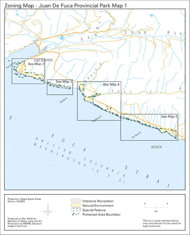
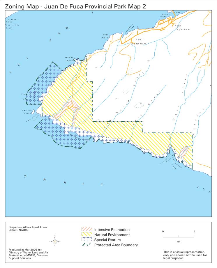
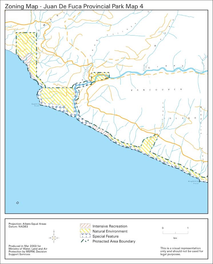
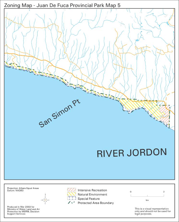
4 Inadequate sani facilities along the Juan de Fuca Trail. Mice, rats and bears may damage visitors equipment and eat human food. Need to upgrade and provide additional facilities to minimize environmental damage and enhance visitors experiences. Install additional pit toilets. Install rodent traps and provide food caches at appropriate wilderness campsites. Facilities are failing. Replacement and additional facilities such as boardwalk are required. Zoning Botanical Beach area, marine foreshore and significant natural and cultural features (such as old growth forests, sandstone formations, rocky headlands, seal grotto, middens, First Nations village site at Sombrio Beach) are zoned Special Features (approximately 32% of the park). The Intensive Recreation Zone comprises the trailheads, vehicle and wilderness campgrounds and day use areas (approximately 8% of the park). The remainder of the park (approximately 60% of the park) is zoned Natural Environment. 4
5 Conservation Representation - ecosection Situated in the well represented Windward Island Mountains Ecosection (17.42%); Juan de Fuca Park contributes only 0.66% of overall protected area representation of this ecosection. The park contributes 9.8% to the protection of the Juan de Fuca Marine Ecosection of which 1.36% is protected provincially. It is ranked 3rd out of 3 in the protection of this marine ecosection. biogeoclimatic subzone/variant Special Feature Rare/Endangered Values Contributes to representation of two subzone/variants; CWHvh1 is well represented (19.34%) in the protected areas system; Juan de Fuca contributes only 0.68% to the protection of this variant. CWHvm1 variant is moderately represented in the protected areas system (7.01%); Juan de Fuca Park contributes only 0.55% of the overall representation of this ecosystem. Botanical Beach is of international significance for marine diversity and protection of tidal pools. There is also a seal grotto at Parkinson Creek. Remnant old growth Douglas-fir and cedar forests are found throughout the park. Cutthroat trout, Nodding semaphore grass and Smith s fairybells blue listed; Northern abalone, marine algae (non vascular plants) in lower intertidal zone: Herposiphonia verticillata, Chiharaea bodegensis, Hollenbergia nigricans red listed. Scientific/Research Opportunities Marine intertidal research since early 1900s. Representation backcountry destination Recreation A popular linear marine trail system with wilderness campsites. Campground/day use at China Beach; Botanical Beach tidal pools, Juan de Fuca trail and wilderness campsites; Sombrio Beach popular with surfers. 5
6 travel corridor local recreation Special Opportunities Education/Interpretation Opportunities Access along popular West Coast Road from Sooke to Port Renfrew and is major tourist attraction. Regional day use and destination use. 47 km of wilderness hiking along coastal trail, camping; nature appreciation, photography and marine life viewing. Botanical Beach renowned for marine life interpretation. Cultural Heritage Representation Special Feature Middens and First Nations village site at Sombrio; West Coast Trail part of old Life Saving emergency route (for mariners). Other Management Considerations Other Designations Relationship to other PAs Part of West Coast wilderness experience; adjacent to Pacific Rim National Park. Co-operative Management Arrangements Partnerships Vulnerability Relationship to other Strategies Local RCMP detachment; Park Watch program; volunteer Emergency Services. Fire and vandalism; loss of marine values from unauthorized recreational and commercial activities. Marine Protected Areas Strategy Area: 1,277 hectares Date of establishment: April 4,
7 7
8 8
9 9
10 10
11 11
Relatively little hard substrate occurs naturally in the
 CHAPTER FIVE Rock Habitats Relatively little hard substrate occurs naturally in the estuary, owing mainly to the vast quantities of fine sediment that have been deposited by the rivers. Rock habitat is
Naturally. Westport... Wet and Wild...
 Westport... Wet and Wild... Naturally A revitalization concept for the City of Westport and Port of Grays Harbor presented by FOGH (Friends of Grays Harbor), Wildlife Forever of Grays Harbor and other
The Problem. Which ecosystems are the most sensitive? Where will ecosystems be migrating? Where will investments be overwhelmed?
 BC Parks BC Parks is responsible for the designation, management and conservation of a system of ecological reserves, provincial parks and recreation areas located throughout the province. British Columbia
Coastal Environment. Introduction. 4.1 Coastal Environment. Extent of Coastal Environment
 4 The primary objective (set out in Chapter 2) to be implemented by this Chapter is Objective 2.4 ; the following objectives are also relevant due to the objectives integrated nature: 2.1 Tāngata whenua
[Leveraging & Improving Neighborhood Connections] Area E Cedar Creek
![[Leveraging & Improving Neighborhood Connections] Area E Cedar Creek](/thumbs/86/93508963.jpg "[Leveraging & Improving Neighborhood Connections] Area E Cedar Creek") Community Charrette LINC Dallas [Leveraging & Improving Neighborhood Connections] Area E Cedar Creek 06.02.12 LINC Workshop Area E Area E has the unique distinction of at-grade frontage to the Trinity
Community Charrette LINC Dallas [Leveraging & Improving Neighborhood Connections] Area E Cedar Creek 06.02.12 LINC Workshop Area E Area E has the unique distinction of at-grade frontage to the Trinity
Chapter 1: Introduction to Safety and Ethics
 Core Curriculum Standards Met by Each Chapter On the Right Trail meets Utah s Social Studies Core Curriculum Standards for grades 3-7. Each chapter has specific standard objectives, which are met by the
Module 10: Resources and Virginia Geology Topic 4 Content: Virginia Geology Notes
 Virginia is composed of a very diverse landscape that extends from the beaches and barrier islands all of the way to the highly elevated Appalachian Plateau. Geologists have discovered ancient shallow
Columbia Estuary Province
 Rolling Provincial Review: Implementation 2001-2004 Province 73 Columbia Basin Fish & Wildlife Authority Province FY 2001-2004 Spending Summaries NPCC Recommendations and BPA Spending by Project Category,
Stabilization Study. Prepared For: The Town of Bethlehem. Henry Hudson Park Shoreline Stabilization Study. June 2011
 Henry Hudson Park Shoreline Stabilization Study Prepared For: The Town of Bethlehem 1 Company Introduction - OCC Ocean and Coastal Consultants (OCC) is a 50 person engineering consulting firm that specializes
Application #: TEXT
 TOWN OF FORT MYERS BEACH 2008 PROPOSED COMPREHENSIVE PLAN AMENDMENTS Application #: 2008-13-TEXT Description: Modify the Coastal Management and Future Land Use Elements to reflect the state s new definition
NORTH VANCOUVER ISLAND MARINE PLAN: OVERVIEW 2015
 NORTH VANCOUVER ISLAND MARINE PLAN: OVERVIEW 2015 North Vancouver Island Marine Plan Overview Refers to: Marine Planning Partnership Initiative. 2015. North Vancouver Island Marine Plan. Copyright 2015
Appendix D ORV Assessment for Clarion River
 Introduction The following ORV assessment criteria were utilized in making WSR eligibility determinations for the 2007 ANF LRMP. These criteria will also be used to assess resource values for the Clarion
Marine Geomorphology as a Determinant for Essential Life Habitat III
 Marine Geomorphology as a Determinant for Essential Life Habitat III marinecoastalgis.net/aag08 10:10 Dawn Wright, Oregon 10:30 Will McClintock, California 10:50 Daniel Sampson, Massachusetts 11:10 Gary
Presentation Outline. Project Overview. Sea Level Rise Assessment & Decision Tools. Community Engagement. Tina Whitman, Friends of the San Juans
 Healthy Beaches for People & Fish Sea Level Rise Adaptation Tools for San Juan County, WA Tina Whitman & Andrea MacLennan December 10, 2015 Presentation Outline Project Overview Tina Whitman, Friends of
Overview of Methods. Terrestrial areas that are most important for conservation Conservation
 Overview of Methods The goal of the Western Lake Erie Coastal Conservation Vision project (WLECCV) is to define where we should be working locally to optimally achieve regional conservation impact. The
Vancouver Island and Coast
 Places in B.C. This handout package provides students with a brief overview of one of seven regions in B.C. These descriptions will help students audit the different types of energy (see the Energy Primers)
Ocean Zones How are the intertidal, neritic, and oceanic zones different?
 Ocean Zones How are the intertidal, neritic, and oceanic zones different? How deep does sunlight travel into the ocean and how does that affect plants and animals? What technology is used to explore the
Weather and Climate in Canada. October 2 nd, 2017
 Weather and Climate in Canada October 2 nd, 2017 Big Ideas How are climate and weather in Canada influenced by geography? How do weather and climate affect the lives of Canadians? Weather and Climate
1. Which of these is an abiotic factor in the tropical rainforest?
 1. Which of these is an abiotic factor in the tropical rainforest? a. fungi b. rain c. bacteria d. fruit 2. The biome is the largest on earth. a. terrestrial b. polar c. freshwater d. marine 3. An aquatic
BISTI / DE-NA-ZIN WILDERNESS
 BISTI / DE-NA-ZIN WILDERNESS Activities: Facilities: Season / Hours: Description: Hiking and photography. No electrical hookups, water, or restrooms are available. Open year-round. The Bisti/De-Na-Zin
The Arctic Landscape Conservation Cooperative Conservation Goals
 The Arctic Landscape Conservation Cooperative Conservation Goals Adopted by the Arctic LCC Steering Committee, 24 August 2010 Background : Landscape Conservation Cooperatives and Climate Science Centers
THE GOVERNOR OF SVALBARD
 Human- Polar Bear conflict reduction workshop 2013 By Espen Stokke, Senior Adviser Nature Management THE GOVERNOR OF SVALBARD Topics Svalbard Environmental Protection Act - New rules on protection in the
EXISTING CONDITIONS : EAST SEGMENT
 EXISTING CONDITIONS : Area of Natural and Interest (ANSI) Environmentally Waterfront Trail Wetlands Hazard Setback Dunes Private Shoreline road ends Unsafe shoreline access Waterfront Trail on route FISH
Map 39 SECTION E: OUTSTANDING COASTAL NATURAL CHARACTER. Legend. Outstanding Coastal Natural Character Areas. Extent of Coastal Environment
 8 289 Legend 1 2 2 3 Extent of Coastal Environment Outstanding Coastal Natural Character Areas 5 Tapuaetahi Bay and Coastline Adjacent Outstanding Coastal Natural Character Areas 4 7 5 6 SECTION E: OUTSTANDING
4.2 Tidal Wetlands. Phragmites Australis
 4.2 Tidal Wetlands Few topics elicit such strong emotions in Guilford as the current state of salt marshes. These marshes, more broadly known as tidal wetlands, are undergoing a transformation as sea level
Opening their Shells Getting commercial clammers involved in marine spatial planning
 Opening their Shells Getting commercial clammers involved in marine spatial planning Ed Lewandowski Coastal Communities Development Specialist University of Delaware/Delaware Sea Grant Highlights Background
Sri Lanka has a coastline of km excluding the shoreline of bays and inlets.
 Defining and Demarcating Coastal zones in Sri Lanka Procedure, Challenges and What needs to be done? Dr. Anil Premaratne Director General Coast Conservation Coast Conservation Department Sri Lanka 1 Sri
5 Coastal Management
 5 Coastal Management 5 C O A S T A L M A N A G E M E N T 5.1 Introduction Otago s coastal marine area extends from the Waitaki River southwards to Wallace Beach (see Figure 1-1). While the land adjacent
Role of Geotourism in Australia s Nature Based Tourism Strategy GlobalEco Angus M Robinson Geotourism Forum, Ecotourism Australia
 Role of Geotourism in Australia s Nature Based Tourism Strategy 2025 - GlobalEco 2016 Angus M Robinson Geotourism Forum, Ecotourism Australia Today s Agenda Nature Based Tourism Strategy 2025 Natural &
Priority areas for grizzly bear conservation in western North America: an analysis of habitat and population viability INTRODUCTION METHODS
 Priority areas for grizzly bear conservation in western North America: an analysis of habitat and population viability. Carroll, C. 2005. Klamath Center for Conservation Research, Orleans, CA. Revised
Kootenai River Habitat Restoration Program Update
 Kootenai River Habitat Restoration Program Update Kootenai Tribe of Idaho Kootenai Valley Resource Initiative November 19, 2012 Bonners Ferry, Idaho Changes to Kootenai Basin Beaver trapping Floodplain
Arizona Recreation Map By Benchmark Maps READ ONLINE
 Arizona Recreation Map By Benchmark Maps READ ONLINE Families can come and see what the Sierra Montana Recreation Center has to offer. The center has a game room with Xbox 360s on high definition TV's,
UNIT 4. ECOSYSTEMS ACTIVITIES
 UNIT 4. ECOSYSTEMS ACTIVITIES Tania Ostolaza Fernández sharpandsavvy.es CHECK YOUR LEARNING Answer the following questions. Use full sentences and be careful with your handwriting. ELEMENTS OF AN ECOSYSTEM
Unit 7: What is an ecosystem?
 Unit 7: What is an ecosystem? Lesson 20 An ecosystem is an area or habitat that contains living and non-living things. The living and non-living things depend on each other in many different ways. An ecosystem
NOAA Nautical Charts and Coastal and Marine Spatial Planning. Meredith Westington Chief Geographer NOAA/NOS/Office of Coast Survey
 NOAA Nautical Charts and Coastal and Marine Spatial Planning Meredith Westington Chief Geographer NOAA/NOS/Office of Coast Survey Ocean Policy Task Force What is CMSP? A comprehensive, adaptive, integrated,
Big Bend National Park Visitor Study
 Big Bend National Park Visitor Study The Visitor Services Project 2 OMB Approval 1024-0099 Expiration Date: 08-15-92 3 DIRECTIONS One adult in your group should complete the questionnaire. It should only
Chapter 7 Case study. Sand dune coastal environment: Studland Bay
 Sand dune coastal environment: Studland Bay Sand dunes are common features of low-lying stretches of coastline in the UK and elsewhere in the world. They form in places where there is a plentiful supply
Moreton Bay and Key Geographic Concepts Worksheet
 Moreton Bay and Key Geographic Concepts Worksheet The Australian Curriculum: Geography draws on seven key geographic concepts: place scale space environment change interconnection sustainability They are
Quantifying effects of oil on coastal dune vegetation. Thomas Miller and Elise Gornish Biological Science, Florida State University
 Quantifying effects of oil on coastal dune vegetation Thomas Miller and Elise Gornish Biological Science, Florida State University Natural History of Barrier Islands in the Northern Gulf Make up ~70% of
Geologic Management. Contents
 Geologic Management Contents Introduction... GM-3 Definitions... GM-3 Legislation and Other Guidance... GM-3 Policy Management for Representation... GM-5... GM-5 Inventory of Significant Geologic Features
Fieldwork at Buffalo Creek Reserve and Sugarloaf Point. A Local Ecosystem NORTH RYDE EAST RYDE. P Mangrove
 A Local Ecosystem Fieldwork at Buffalo Creek Reserve and Sugarloaf Point Map of Buffalo Creek Reserve and Sugarloaf Point NORTH RYDE EAST RYDE C T P Map: Walking Tracks of the Lane Cove Valley, STEP Inc
Marine Spatial Data for Marine Spatial Planning. Ocean Leadership 2010 Public Policy Forum
 Marine Spatial Data for Marine Spatial Planning Ocean Leadership 2010 Public Policy Forum March 10, 2010 Edward Saade President, Fugro EarthData, Inc 1 Marine Spatial Data What is Marine Spatial Data?
Topographic Recreational Map Of New Mexico: Detailed Travel Map By GTR Mapping
 Topographic Recreational Map Of New Mexico: Detailed Travel Map By GTR Mapping Biological Assessment for Proposed Reconstruction of New Mexico Forest Highway 12. Cuba and Jemez Recreation Opportunity Spectrum
Mapping on the Edge: shoreline mapping for regulation and voluntary stewardship
 Western Washington University Western CEDAR Salish Sea Ecosystem Conference 2016 Salish Sea Ecosystem Conference (Vancouver, BC) Mapping on the Edge: shoreline mapping for regulation and voluntary stewardship
Evaluation of Environmental Effects on Tourism Development in Penghu Islands
 Evaluation of Environmental Effects on Tourism Development in Penghu Islands Dr. Shui-Liang Yu, Professor of National Penghu University of Science and Technology, Taiwan Ying-Chien Chu, Corresponding Author,
Paper Reference. Paper Reference(s) 1312/2F Edexcel GCSE Geography A Foundation Tier. Monday 11 June 2007 Afternoon Time: 1 hour 15 minutes
 1312/2F Edexcel GCSE Geography A Foundation Tier. Monday 11 June 2007 Afternoon Time: 1 hour 15 minutes") Centre No. Paper Reference Surname Initial(s) Candidate No. 1 3 1 2 2 F Signature Paper Reference(s) 1312/2F Edexcel GCSE Geography A Foundation Tier Paper 2F Monday 11 June 2007 Afternoon Time: 1 hour
Centre No. Paper Reference Surname Initial(s) Candidate No. 1 3 1 2 2 F Signature Paper Reference(s) 1312/2F Edexcel GCSE Geography A Foundation Tier Paper 2F Monday 11 June 2007 Afternoon Time: 1 hour
Sediment Management in the Coastal Bays
 Sediment Management in the Coastal Bays Introduction Need for ecosystem view of sediment management in Coastal Bays Island loss and restoration Navigation needs Habitat Trade offs Living Shoreline Requirements
Biomes of the World What is a Biome?
 Biomes of the World What is a Biome? A large, relatively distinct terrestrial region with characteristic Climate Soil Plants Animals Interacting landscapes 1 Terrestrial Biomes Using Precipitation And
Catastrophic Events Impact on Ecosystems
 Catastrophic Events Impact on Ecosystems Hurricanes Hurricanes An intense, rotating oceanic weather system with sustained winds of at least 74 mph and a welldefined eye Conditions for formation: Warm water
TOWARDS CLIMATE-RESILIENT COASTAL MANAGEMENT: OPPORTUNITIES FOR IMPROVED ICZM IN BELIZE
 TOWARDS CLIMATE-RESILIENT COASTAL MANAGEMENT: OPPORTUNITIES FOR IMPROVED ICZM IN BELIZE CHANTALLE SAMUELS Coastal Zone Management Authority and Institute The Caribbean Community Climate Change Centre VULNERABILITY
Cross Boundary Issues
 6 Cross Boundary Issues 6 C R O S S B O U N D A R Y I S S U E S 6.1 Introduction The effects of an activity within the coastal marine area are often felt in adjacent areas, outside of the immediate vicinity
2 Georgia: Its Heritage and Its Promise
 TERMS region, erosion, fault, elevation, Fall Line, aquifer, marsh, climate, weather, precipitation, drought, tornado, hurricane, wetland, estuary, barrier island, swamp PLACES Appalachian Mountains, Appalachian
Most people used to live like this
 Urbanization Most people used to live like this Increasingly people live like this. For the first time in history, there are now more urban residents than rural residents. Land Cover & Land Use Land cover
Groups of organisms living close enough together for interactions to occur.
 Community ecology: First, let's define a community: Groups of organisms living close enough together for interactions to occur. First we probably want to describe the community a bit, so we look at: Biodiversity
Haida Gwaii Queen Charlotte Islands
 Haida Gwaii Queen Charlotte Islands H E R I T A G E T O U R I S M STRATE GY January 2003 Haida Gwaii/Queen Charlotte Islands Heritage Tourism Strategy Working Group The Haida Gwaii/Queen Charlotte Islands
An Introduction to Day Two. Linking Conservation and Transportation Planning Lakewood, Colorado August 15-16, 16, 2006
 An Introduction to Day Two Linking Conservation and Transportation Planning Lakewood, Colorado August 15-16, 16, 2006 1 Agenda Day One Transportation Planning Heritage Program State Wildlife Action Plan
Lassen Volcanic National Park Visitor Study
 Lassen Volcanic National Park Visitor Study The Visitor Services Project OMB Approval 1024-0224 Expiration Date: 02/29/2000 United States Department of the Interior NATIONAL PARK SERVICE Lassen Volcanic
1.1 What is Site Fingerprinting?
 Site Fingerprinting Utilizing GIS/GPS Technology 1.1 What is Site Fingerprinting? Site fingerprinting is a planning tool used to design communities where protection of natural resources is the primary
PROPOSED UNESCO FUNDY BIOSPHERE RESERVE
 OVERVIEW PROPOSED UNESCO FUNDY BIOSPHERE RESERVE NEW BRUNSWICK, CANADA NOMINATION DOCUMENT April 10, 2007 The United Nations Educational, Scientific and Cultural Organization (UNESCO) Man and the Biosphere
Great California Delta Trail Blueprint for Contra Costa and Solano Counties GIS AND MAPPING MEMORANDUM JULY 2010
 Great California Delta Trail Blueprint for Contra Costa and Solano Counties GIS AND MAPPING MEMORANDUM JULY 2010 {DRAFT} July 2010 Introduction Geographic Information Systems (GIS) are computer-based
HELSINKI COMMISSION Baltic Marine Environment Protection Commission
 HELSINKI COMMISSION Baltic Marine Environment Protection Commission HELCOM RECOMMENDATION 24/10 Adopted 25 June 2003, having regard to Article 20, Paragraph 1 b) of the 1992 Helsinki Convention IMPLEMENTATION
[LLAZC X.L EA0000; AZ SRP ] Notice of Temporary Closures: Selected Public Lands in La Paz County, AZ
![[LLAZC X.L EA0000; AZ SRP ] Notice of Temporary Closures: Selected Public Lands in La Paz County, AZ](/thumbs/89/100188672.jpg "[LLAZC X.L EA0000; AZ SRP ] Notice of Temporary Closures: Selected Public Lands in La Paz County, AZ") This document is scheduled to be published in the Federal Register on 12/29/2017 and available online at https://federalregister.gov/d/2017-28217, and on FDsys.gov 4310-32 DEPARTMENT OF THE INTERIOR Bureau
This document is scheduled to be published in the Federal Register on 12/29/2017 and available online at https://federalregister.gov/d/2017-28217, and on FDsys.gov 4310-32 DEPARTMENT OF THE INTERIOR Bureau
Lesson 3: Protecting Ocean Hotspots
 Lesson 3: Protecting Ocean Hotspots Name: Date: Engage Think about the ocean and the seafloor. 1. Draw a sketch of what you picture when you think about the seafloor. Explore 2. When your teacher projects
Plate 51. Site 035. Collection of remains. Scale is in cm. Plate 50. Site 034. Collection of remains. Scale is in cm
 Plate 48. Site 033. View facing north west Plate 49. Site 034. View facing north Pottery Pottery Ostrich eggshell Plate 50. Site 034. Collection of remains. Scale is in cm Plate 51. Site 035. Collection
ESTIMATING THE SOCIAL & ENVIRONMENTAL EFFECTS OF ADVENTURE TOURISM AND RECREATION ON CROWN LAND IN BRITISH COLUMBIA
 ESTIMATING THE SOCIAL & ENVIRONMENTAL EFFECTS OF ADVENTURE TOURISM AND RECREATION ON CROWN LAND IN BRITISH COLUMBIA Wolfgang Haider School of Resource and Environmental Mgt. Simon Fraser University Burnaby,
V E R M E J O P A R K R A N C H
 V E R M E J O P A R K R A N C H ABOUT TED TURNER EXPEDITIONS Ted Turner Expeditions is rooted in two million acres of wild, private North American landscape acquired by Ted Turner as a pioneering investment
Northland Regional Landscape Assessment Worksheet
 Northland Regional Landscape Assessment Worksheet DESCRIPTION AND CHARACTERISATION Component Land Types (refer to list overleaf) Ranges; high relief Unit name HEREKINO BUSH-CLAD HILLS Comment A large,
Table-Top Exercise for Emergency Preparedness Evaluation: Little Anse, Isle Madame
 Table-Top Exercise for Emergency Preparedness Evaluation: Little Anse, Isle Madame Alexander Chung, M.Sc. Candidate C-Change Student Research Associate May 2013 The Community of Little Anse Coastal community
Abiotic Dominant Dominant Factors Plants Animals
 TERRESTRIAL BIOMES Abiotic Dominant Dominant Factors Plants Animals Tropical Rain Forest Hot & wet year round Ferns Woody vines Broad leaved evergreen trees Sloths Jaguars Monkeys Toucans Tropical Dry
CHAPTER 4 HIGH LEVEL SPATIAL DEVELOPMENT FRAMEWORK (SDF) Page 95
 Page 95") CHAPTER 4 HIGH LEVEL SPATIAL DEVELOPMENT FRAMEWORK (SDF) Page 95 CHAPTER 4 HIGH LEVEL SPATIAL DEVELOPMENT FRAMEWORK 4.1 INTRODUCTION This chapter provides a high level overview of George Municipality s
CHAPTER 4 HIGH LEVEL SPATIAL DEVELOPMENT FRAMEWORK (SDF) Page 95 CHAPTER 4 HIGH LEVEL SPATIAL DEVELOPMENT FRAMEWORK 4.1 INTRODUCTION This chapter provides a high level overview of George Municipality s
BOARD OF COUNTY COMMISSIONERS AGENDA ITEM SUMMARY
 7H BOARD OF COUNTY COMMISSIONERS AGENDA ITEM SUMMARY PLACEMENT: REQUESTS AND PRESENTATIONS PRESET: TITLE: PARKS FY 2012 CAPITAL IMPROVEMENT PLAN (CIP) AGENDA ITEM DATES: MEETING DATE: 4/26/2011 COMPLETED
Auckland Council District Plan Hauraki Gulf Islands Section Operative 2013 Proposed plan modification no. 1: Plan Change
 Page 1 Auckland Council District Plan Hauraki Gulf Islands Section Operative 2013 Proposed plan modification no. 1: Plan Change Date of public notification: 31 May 2013 Closing date for submission: 1 July
A Comparison of the Social Valuation of Ecosystem Services in Urban and Rural Contexts
 A Comparison of the Social Valuation of Ecosystem Services in Urban and Rural Contexts Jarrod L. Loerzel College of Charleston Zachary D. Cole University of Florida Presentation Map 1. What is SolVES?
Your web browser (Safari 7) is out of date. For more security, comfort and the best experience on this site: Update your browser Ignore
 is out of date. For more security, comfort and the best experience on this site: Update your browser Ignore") Your web browser (Safari 7) is out of date. For more security, comfort and the best experience on this site: Update your browser Ignore ISTHMU S tombolo For the complete encyclopedic entry with media resources,
Your web browser (Safari 7) is out of date. For more security, comfort and the best experience on this site: Update your browser Ignore ISTHMU S tombolo For the complete encyclopedic entry with media resources,
Alamito Creek Preserve Ranches for Sale Marfa, Presidio County, Texas
 Alamito Creek Preserve Ranches for Sale Marfa, Presidio County, Texas James King, Agent Office 432 426.2024 Cell 432 386.2821 James@KingLandWater.com Alamito Creek Preserve Various size Ranch Properties,
Long Term Plan What is planned for Murchison?
 Long Term Plan 2018-2028 What is planned for Murchison? 1.0 Introduction The following information provides an overview of significant projects Council has planned for the Murchison settlement in the Long
NATURE AND EXTENT OF PROPOSED DEVELOPMENT. Amount of Development Development Zones Distribution of Density Policies
 NATURE AND EXTENT OF PROPOSED DEVELOPMENT Amount of Development Development Zones Distribution of Density Policies DRAFT POOLBEG PLANNING SCHEME Amount of Development 78 4.1 The rationale for the overall
Shoreline and Climate Change Adaptation Alternatives for The Letter Parcel, Bolinas Lagoon
 Shoreline and Climate Change Adaptation Alternatives for The Letter Parcel, Bolinas Lagoon Scenic shoreline vista of Bolinas Lagoon and ridges, from Letter Parcel, March 2016 Peter Baye, Coastal Ecologist
BIOMES. Copyright Cmassengale
 BIOMES Biogeography - study of where organisms live Continental drift - slow motion of continents Dispersal of organisms Movement of organisms from 1 place to another Dispersal is usually caused by wind,
Scenarios for the NI coast in the 21 st Century
 Scenarios for the NI coast in the 21 st Century Prof Julian Orford Geography, Archaeology & Palaeoecology Queen s University, Belfast Challenging perspective Living by the coast is good for your health!
Mapping Maine s Working Waterfront: for Our Heritage and Economy
 Mapping Maine s Working Waterfront: for Our Heritage and Economy Abstract Mapping Maine s Working Waterfronts is a collaborative project led by the Island Institute that inventories the state s current
CRITERIA FOR THE ASSESSMENT OF OUTSTANDING UNIVERSAL VALUE
 CRITERIA FOR THE ASSESSMENT OF OUTSTANDING UNIVERSAL VALUE Workshop of National Focal Points of Central, South-East and Eastern European Countries on the Preparation of the Second Cycle of the Periodic
Delta Flood Protection Strategy Update. May 16, 2016
 Delta Flood Protection Strategy Update May 16, 2016 Presentation Overview 1. Background 2. Understanding the Dike Reaches/Issues 3. Future Dike Improvements 4. Next Steps Boundary Bay Village March 10,
Resolution XIII.23. Wetlands in the Arctic and sub-arctic
 13th Meeting of the Conference of the Contracting Parties to the Ramsar Convention on Wetlands Wetlands for a Sustainable Urban Future Dubai, United Arab Emirates, 21-29 October 2018 Resolution XIII.23
Multiple services provided by protected-areas in times of crises and implication for socio-ecological systems resilience
 Multiple services provided by protected-areas in times of crises and implication for socio-ecological systems resilience Insights from Hwange SES in Zimbabwe by Chloé Guerbois, Carli Bunding-Venter & Hervé
Canada Land Inventory (CLI) CANADA LAND INVENTORY LEVEL-I LAT/LONG DIGITAL DATA LAND CAPABILITY FOR RECREATION. 1.0 Coverage Specifications
 CANADA LAND INVENTORY LEVEL-I LAT/LONG DIGITAL DATA LAND CAPABILITY FOR RECREATION. 1.0 Coverage Specifications") Canada Land Inventory (CLI) CANADA LAND INVENTORY LEVEL-I LAT/LONG DIGITAL DATA LAND CAPABILITY FOR RECREATION 1.0 Coverage Specifications Original Map Scale: 1:250,000 Resolution :.00024414 of a degree
Canada Land Inventory (CLI) CANADA LAND INVENTORY LEVEL-I LAT/LONG DIGITAL DATA LAND CAPABILITY FOR RECREATION 1.0 Coverage Specifications Original Map Scale: 1:250,000 Resolution :.00024414 of a degree
Beaches Carrying Capacity Assessment in Kuwait Based on Photointerpretation and Ground Survey
 Technical Session: TS 07B - GIS Applications (Number # 5463) Beaches Carrying Capacity Assessment in Kuwait Based on Photointerpretation and Ground Survey Prof. Mohamed AIT BELAID Shaikh Hamad Bin Khalifa
WELCOME & INTRODUCTION
 MPA Management Capacity Building Training Module 1: WELCOME & INTRODUCTION Participants Distinguished Guests Welcome Site Overviews of MPAs represented Overview of Training Program What are Today s Objectives?
Coastal Impacts of Climate Change in the Northwest: A Summary of the Findings of the upcoming National Climate Assessment
 Western Washington University Western CEDAR Salish Sea Ecosystem Conference 2014 Salish Sea Ecosystem Conference (Seattle, Wash.) May 1st, 3:30 PM - 5:00 PM Coastal Impacts of Climate Change in the Northwest:
Food Web and Ecological Relationships Quiz
 Biology II Ms. Chen Name: Food Web and Ecological Relationships Quiz Date: Multiple Choice (2 pts each) Directions: Circle the best answer. 1. The loss of the producers in an ecosystem would most likely
Background. North Cascades Ecosystem Grizzly Bear Restoration Plan/ Environmental Impact Statement. Steve Rochetta
 Grizzly Bear Restoration Plan/ Environmental Impact Statement Steve Rochetta Background Situated in the core of the North Cascades ecosystem (NCE), the North Cascades National Park Complex is surrounded
How to Read These Flood Hazard Maps
 How to Read These Flood Hazard Maps The United States Geological Survey (USGS) has developed the Coastal Storms Modeling System (CoSMoS), which projects coastal flooding and erosion from coastal storms,
EXPLORER S GUIDE FOR A SELF-GUIDED VISIT. Welcome to the Arizona-Sonora Desert Museum!
 EXPLORER S GUIDE FOR A SELF-GUIDED VISIT Welcome to the Arizona-Sonora Desert Museum! Instructions: Review the questions in this guide before you visit the Desert Museum. You should be able to find all
Hiking the Bold Coast, Cutler, Maine
 Maine Geologic Facts and Localities June, 2010 Hiking the Bold Coast, Cutler, Maine 44 o 39 36.34 N, 67 o 12 46.99 W Text by Robert A. Johnston, Department of Agriculture, Conservation & Forestry 1 Map
Spatial Decision-Support for National Marine Conservation Areas in the Southern Strait of Georgia and Gwaii Haanas
 Spatial Decision-Support for National Marine Conservation Areas in the Southern Strait of Georgia and Gwaii Haanas Lindsay McBlane Krista Royle Greg MacMillan Photo: Mark Hiebert Western and Northern Service
Designing Networks of Marine Protected Areas in DFO s Three Atlantic Bioregions
 Designing Networks of Marine Protected Areas in DFO s Three Atlantic Bioregions Presentation for Indigenous Protected Areas Workshop Max Westhead, DFO and Adrian Gerhartz-Abraham, Dalhousie March 29, 2017
Gespe gewaq Mi gmaq. Resource Council. Coastal Erosion Awareness. Ugpi ganjig Sitmug Eel River Bar Beach
 Gespe gewaq Mi gmaq Resource Council Coastal Erosion Awareness Ugpi ganjig Sitmug Eel River Bar Beach 2 Table of Contents Introduction...1 Driving Force 1:...2 Sensitivity to Sea-Level Rise Driving Force
Senja. A guide to exploring Norway s wild northern coast
 Senja A guide to exploring Norway s wild northern coast About Senja 4 When to go 5 Permits 8 Good to know 8 Outtt for Android and ios 9 Getting to and from Senja 10 Oslo 10 Lofoten and Vesterålen via Andøya
GRIZZLY AND BLACK BEARS
 . Grizzly and Black Bear Management Project Statement From s Resource Management Plan August, 1998 GRIZZLY AND BLACK BEARS PROJECT CODE: DENA-N-364.2 SERVICEWIDE ISSUES: N18 Visitor Use Impacts on Backcountry
PARC NATUREL DE LA MER DE CORAIL. The planned management project. with 15 objectives. Jean-Michel Boré - IRD
 Jean-Michel Boré - IRD PARC NATUREL DE LA MER DE CORAIL The planned management project with 15 objectives 1 CHAPTER 1 Protected natural and cultural heritage OBJECTIVE 1 Carefully protect the ecosystems