Flood Hazard Map - a tool for comprehensive flood management-
|
|
|
- Bernadette Bryan
- 5 years ago
- Views:
Transcription
1 Flood Hazard Map - a tool for comprehensive flood management- Kenzo Hiroki National Institute for Land and Infrastructure Management Ministry of Land, Infrastructure and Transport
2 Flood Hazard (Awareness) Map is defined as : a map that provides with geographical information that is essential for local residents to conduct safe & smooth evacuation
3 When flood comes Residents : are not aware of possible flooding at their home are not willing to move even when danger is coming close do not know how to react to warnings do not know where to evacuate
4 When flood comes Flood response (civil defense) officials : are immersed with (mis-)information & cry for help have to triage various needs for actions may not know what are actually happening in the field Flood Hazard Map is a tool to mitigate recurrent tragedies by addressing lack and/or confusion of essential information for evacuation
5 Dilemma of Disaster Managers Disaster response is struggle against confused information Disaster managers have much less time to gather/analyze/transmit emergency information Information is necessarily confused during disasters Trade-off between accuracy & collection time of information

6 Example Abukuma River Flooding in :00 August 26 to 9:00 September 1 (total precipitation in six days) Rainfall map Pacific Ocean Mafune Rainfall Ganging Station: maximum hourly precipitation of 90 mm total precipitation of 1,268 mm in a week
 Water level (Sukagawa River) Water level August 26 August 27 August 28 August 29 August 30 August 31 September 1 6 days of flooding above")
7 Precipitation and change in water level 14:00 Precipitation 15:00 Maximum hourly precipitation 時間最大 90mm of 90 mm Warning stage Specified stage Water level (m) Precipitation (at Mafune) Water level (Sukagawa River) Water level August 26 August 27 August 28 August 29 August 30 August 31 September 1 6 days of flooding above specified alert level

8 Overflow of the river Sukagawa City Main stream Shakado River

9 Overflow of the river Koriyama City Ose River Main stream
10 Disaster Response Manager has to in this case give appropriate response directives to critical areas communicate with local mayors on residents evacuation discuss with supervising organizations manage media relations to ensure accurate disaster news coverage Priority of tasks have to be changed according to the disaster status
11 Measures taken when the bank collapsed in the Arakawa District (Top priority given to the communication with the head of the municipal government) 8:30 The patrol staff reported that the bank had started to break off and was highly likely to collapse. 8:40 The office judged that the bank would collapse, and asked the mayor to issue the evacuation order. Setting up of hotline between the Mayor and the Flood office 9:00 About 500 households received the evacuation order. 9:02 The bank collapsed. 11:20 The office requested the dispatch of the Defense Force. 13:00 The office started to repair the broken section of the bank after the water level dropped below the specified level. 2:00 on the next day The broken section was sealed.

12 Start of bank breaching at 8:29 a.m.
13 8:30 a.m.
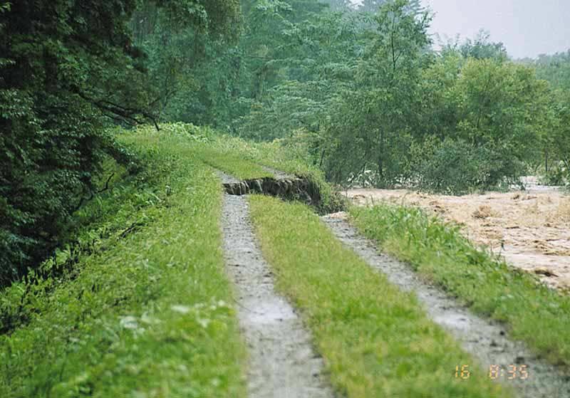
14 8:35 a.m.
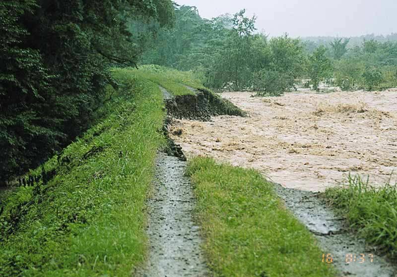
15 8:37 a.m.

16 Collapsed at 9:02 a.m.
17 Flood Hazard Map is a tool to help disaster response officials ; to train themselves for flood response actions ; to take appropriate actions in emergency
18 People are not willing to move even when actual danger is drawing near Number of people who have (not) evacuated and their reason in Section a : Voluntarily evacuated Section b : Evacuated when directives issued Section c : Not evacuated because they judged evacuation was not necessary Section d : Not evacuated because they did not know how to do Section e : Not evacuated because necessary information was not available Section f : Not evacuated because the area was already flooded
19 It is often too late when people decide to evacuate (case of Ise-Wan Typhoon in 1959) Water depth in which evacuation is possible Water depth (assumption) 70cm Adults 30cm 20 Children Male Number of persons cm cm 20 Female Water depth when adults lost the accompanying children 45cm 25 Water depth when children lost the accompanying adults 60cm
20 Status of belongings when evacuating Evacuated without belongings 12% Evacuated with belongings 88% Have thrown away their belongings 46% Have not thrown away their belongings 42%
21 Flood Hazard Map is a tool to help residents to be preliminarily prepared for flooding ; to be alert when flood occurs ; to safely evacuate in emergency
22 How effective are Flood Hazard Maps? Result of research in Koriyama City in 1998 flooding Survey by Prof. Katada, Gunma Univ. 1 Quicker evacuation 2 Higher evacuation ratio 3 Correct direction to evacuate
23 Effectiveness of flood hazard maps In case of Koriyama City in 1998 flooding Peak of evacuation after order to evacuate Approximately One hour Those who saw the Hazard Map Those who did not see the Hazard Map Advice to Order to evacuate evacuate Source: Survey Report on Local Residents Reactions in the Rainstorm in Koriyama at the End of August 1998 Katada Laboratory, Faculty of Engineering, Gunma Univ.
24 Effectiveness of flood hazard maps In case of Koriyama City in 1998 flooding Rate of evacuation 30% 20% 10% Rate of evacuation six hours after advice to evacuate 1.5 times 0% Those who did not see the Hazard Map Those who saw the Hazard Map Source: Survey Report on Local Residents Reactions in the Rainstorm in Koriyama at the End of August 1998 Katada Laboratory, Faculty of Engineering, Gunma Univ.
25 Number of Flood Hazard Maps in Japan 400 by march Number in the year Total number estimate till summer of 2003
26 Legal framework of Flood Hazard Mapping in Japan River authorities (Central / Prefectural governments) Information on possible inundation areas (Technical advice when map planning) Flood Hazard Map planners (Local governments) Planning Committee Draft Maps Inquiry to community information Local governments Advisers (researchers, experts, etc.) Residents Residents Feedbacks to draft maps Community information


27 Flood Hazard Map (example of Koriyama City) Akutsu bridge Ause River Koriyama Central Gymnasium Umeda punping station Yokotsuka punping station Enjuji Temple Yasuhara bridge Yamazaki community hall River Abukuma Yata River Otakine River
28 Process of Production and Distribution of the Flood Hazard Map 1 Collect and classify information 2 Set-up Basic Conditions 3 Draw-up Historical Flood Map 4 Draw-up Predicted Flood Area Map 5 Draw-up Evacuation Scenarios 6 Establish Evacuation Criteria 7 Produce Flood Hazard Map 8 Distribute and Dissemination among residents 7 Use in Municipalities

29 Inundation area by the Ise-Wan Typhoon in 1959
30 Flood Simulation Hydrological data Hydrograph of the target flood Data on Dike-collapse Meshed data of Floodplain (mesh size about 250m for calculation) Ground level Ground roughness (according to land use) Other data of Floodplain Drainage channels Banks Pumps etc. FLOOD SIMULATION MODEL 1D or 2D model based on the equation of continuity and the equation of motion Time variation of inundation depth, velocity, etc. Hazard mapping Info. on evacuation, etc.

31 Flood Simulation Cases Levee break point Draw the flooding boundary from the calculation at all levee break points
32 Additional information in the Flood Hazard Map Guidance to the Flood Hazard Map Information source to residents Emergency take-out kit checklist Flooding mechanism Guidance to warning
33 Guidance to Flood Hazard Map Flooding mechanism Topographic features and flooding types Real danger of flood, Predicted extent of damage Meteorological information Past flood records (rainfall, inundation, and damage) Rules to follow in cases of flood Explanation and directions to use Flood Hazard Maps Preparedness against flood

34 Information source for residents

35 Emergency take-out kit checklist

36 Flooding mechanism
37 The evaluation items in Hazard-Map by citizens Location of shelters Past flood records Information flow of flooding / warning 150 Family In the flood of torrential rain (26,Aug.~1,Sep.in1998) Dangerous places when evacuating Check list when evacuating Expected water depth Actions to be taken when evacuation directive is issued Evacuation kit check list useful not useful
38 Be careful! - Inadvertent effect of Flood Hazard Map 1. Fixation problem (a) Residents tend to think the flood size described in Flood Hazard Map will be the same as that of the coming flood It should be more or less, but not the same maximum depth (by Prof. Katada)

39 (b) Flood Hazard Map can be interpreted as Flood-Free Area Map Dangerous Never be inundated! (by Prof. Katada)
40 2. Interpretation problem People may not understand how difficult it is to evacuate in flooded roads even though they are shallow Water depth (assumption) 70cm Adults Male Number of persons 70cm Female Water depth in which evacuation is possible 30cm 20 Children cm
41 Thank you for your attention!
42 Set-up Basic Condition (1) Magnitude of Target Flood Design flood The largest flood recorded in the past Flood that may occur once in several years (2) Areas to be mapped Inundation areas and their surrounding areas should be mapped The neighboring areas should be included in a map when the potential flood areas include neighboring municipalities.
43 Set-up Basic Condition (3) Scale and Size of Base Maps Standard scale of base maps should be 1/10,000 to 1/15,000 because identification of not only individual houses but evacuation routes and the extent of inundation are necessary Standard size of base maps : A0 to A1 as they are easy to handle
44 Drawing-up of Historical Flood Map old residents in the area
45 Drawing-up Predicted Flood Area Map Identify current status of levees Identify existing crosssection al areas of river channel Identify current status of river m anagem ent facilities such as flood control facilities, their annexed dikes, etc. Identify w ater levels on various spots along the river channel that allow discharge w ithout flooding W ater levels in river channel through the w ater level ca lcu lation m eth od used in cases of channel im provem ent. Identify flood discharge, on the basis of target rainfall Identify discharge at the start of flooding Id en tify p ossible hydrograph on various spots along the river channel Identify possible flooding spots D efine the target flood plain Identify topographical features of the target flood plain D efin e p rem ises for Flood Sim ulation Analysis b y lev ee b rea k a n d sp ill overtop p in g F lood S im u la tion A n a ly sis D efin e flood -p ron e area Represent inundation depth D raw -up Flood-prone Area M ap
46 Guide to warning

47 Collapse of the bank in Arakawa District
Rebuilding Flood-Conscious Society
 A zone where strong flood flow or river bank erosion by levee breach are anticipated, which likely to occur collapsing/washing away of house. Set up the joint councils by relative stakeholders(river managers,
Progress Report. Flood Hazard Mapping in Thailand
 Progress Report Flood Hazard Mapping in Thailand Prepared By: Mr. PAITOON NAKTAE Chief of Safety Standard sub-beuro Disaster Prevention beuro Department of Disaster Prevention and Mitigation THAILAND E-mail:
Flood Management in Japan
 Flood Management in Japan 1. Comprehensive Flood Control Measures 2. Provision of River information 3. Responses to the Niigata Torrential Rain Disaster 4. About ICHARM 5. Responses to 2011 Thailand Floods
GENERAL. CHAPTER 1 BACKGROUND AND PURPOSE OF THE GUIDELINES Background of the Guidelines Purpose of the Guidelines...
 GENERAL CHAPTER 1 BACKGROUND AND PURPOSE OF THE GUIDELINES... 1 1.1 Background of the Guidelines... 1 1.2 Purpose of the Guidelines... 3 CHAPTER 2 APPLICATION OF THE GUIDELINES... 3 2.1 Potential Users
Outline of Guideline for Development and Utilization of Tsunami Disaster Management Map
 Outline of Guideline for Development and Utilization of Tsunami Disaster Management Map Port and Airport Research Institute, Japan The Overseas Coastal Area Development Institute of Japan Ports and Harbours
FLOOD HAZARD MAPPING OF DHAKA-NARAYANGANJ-DEMRA (DND) PROJECT USING GEO-INFORMATICS TOOLS
 PROJECT USING GEO-INFORMATICS TOOLS") FLOOD HAZARD MAPPING OF DHAKA-NARAYANGANJ-DEMRA (DND) PROJECT USING GEO-INFORMATICS TOOLS Md. Aminul Islam MEE07178 Supervisor: Prof. Kuniyoshi TAKEUCHI ABSTRACT Dhaka-Narayanganj-Demra (DND) Project is
FLOOD HAZARD MAPPING OF DHAKA-NARAYANGANJ-DEMRA (DND) PROJECT USING GEO-INFORMATICS TOOLS Md. Aminul Islam MEE07178 Supervisor: Prof. Kuniyoshi TAKEUCHI ABSTRACT Dhaka-Narayanganj-Demra (DND) Project is
What Are Disasters? The Rescue Kids Trio!
 The Rescue Kids Trio! What Are Disasters? This manual was made possible through funding by the Council of Local Authorities for International Relations. Disasters and emergency preparedness Emergency preparedness
HISTORY OF HEAVY RAINFALL DISASTER INFORMATION IN JAPAN
 transmission, for a state-of-the-art review. In addition, issues expected to arise in the future are discussed. HISTORY OF HEAVY RAINFALL DISASTER INFORMATION IN JAPAN Progress of Rainfall Observation
THE 3D SIMULATION INFORMATION SYSTEM FOR ASSESSING THE FLOODING LOST IN KEELUNG RIVER BASIN
 THE 3D SIMULATION INFORMATION SYSTEM FOR ASSESSING THE FLOODING LOST IN KEELUNG RIVER BASIN Kuo-Chung Wen *, Tsung-Hsing Huang ** * Associate Professor, Chinese Culture University, Taipei **Master, Chinese
HYDRAULIC MODELLING OF NENJIANG RIVER FLOODPLAIN IN NORTHEAST CHINA
 HYDRAULIC MODELLING OF NENJIANG RIVER FLOODPLAIN IN NORTHEAST CHINA Xiao Fei MEE08181 Supervisor: A.W. Jayawardena ABSTRACT In 1998, the worst flood recorded for over 200 years hit the Songhua River Basin
Appendix E Guidance for Shallow Flooding Analyses and Mapping
 Appendix E Guidance for Shallow Flooding Analyses and Mapping E.1 Introduction Different types of shallow flooding commonly occur throughout the United States. Types of flows that result in shallow flooding
GUIDELINES FOR CONSTRUCTION TECHNOLOGY TRANSFER DEVELOPMENT OF WARNING AND EVACUATION SYSTEM AGAINST SEDIMENT DISASTERS IN DEVELOPING COUNTRIES
 GUIDELINES FOR CONSTRUCTION TECHNOLOGY TRANSFER DEVELOPMENT OF WARNING AND EVACUATION SYSTEM AGAINST SEDIMENT DISASTERS IN DEVELOPING COUNTRIES MARCH 2004 Ministry of Land, Infrastructure and Transport
Slope Management Planning for the Mitigation of Landslide Disaster in Urban Areas
 Slope Management Planning for the Mitigation of Landslide Disaster in Urban Areas Keiko Inagaki* 1 and Satoru Sadohara 2 1 Research Associate, Graduate School of Environment and Information Sciences, Yokohama
Striving Sufficient Lead Time of Flood Forecasts via Integrated Hydro-meteorological Intelligence
 Striving Sufficient Lead Time of Flood Forecasts via Integrated Hydro-meteorological Intelligence Dong-Sin Shih Assistant Professor, National Chung Hsing University, Taiwan, Sep. 6, 2013 Outlines Introductions
Earth Science Floods
 Non-fiction: Earth Science - Floods Earth Science Floods When dry land is covered by water, we call it a flood. Floods are very dangerous. If they are very bad, homes can be destroyed, and people can die.
EIT-Japan Symposium 2011 on Human Security Engineering
 EIT-Japan Symposium 2011 on Human Security Engineering 2011 Disastrous Landslides at Khao Panom, Krabi, Thailand Suttisak Soralump Geotechnical Engineering Research and Development Center (GERD) Faculty
Flash Flood Guidance System On-going Enhancements
 Flash Flood Guidance System On-going Enhancements Hydrologic Research Center, USA Technical Developer SAOFFG Steering Committee Meeting 1 10-12 July 2017 Jakarta, INDONESIA Theresa M. Modrick Hansen, PhD
Risk-based land use and spatial planning
 Risk-based land use and spatial planning Miho OHARA International Centre for Water Hazards and Risk Management (ICHARM) Public Works Research Institute PWRI), Japan Under the auspices of UNESCO Introduction
FLOOD HAZARD AND RISK ASSESSMENT IN MID- EASTERN PART OF DHAKA, BANGLADESH
 FLOOD HAZARD AND RISK ASSESSMENT IN MID- EASTERN PART OF DHAKA, BANGLADESH Muhammad MASOOD MEE07180 Supervisor: Prof. Kuniyoshi TAKEUCHI ABSTRACT An inundation simulation has been done for the mid-eastern
United States Multi-Hazard Early Warning System
 United States Multi-Hazard Early Warning System Saving Lives Through Partnership Lynn Maximuk National Weather Service Director, Central Region Kansas City, Missouri America s s Weather Enterprise: Protecting
Heavy Rainfall Disaster in Eastern Japan Caused by Typhoon 0206 from July 9 to 12, 2002
 Journal of Natural Disaster Science, Volume 25, Number 2, 2003, pp57-63 Heavy Rainfall Disaster in Eastern Japan Caused by Typhoon 0206 from July 9 to 12, 2002 Motoyuki USHIYAMA Disaster Control Research
Mitigation planning in Epirus- The case of frost and snowfalls. Thematic seminar Epirus September 2011
 Mitigation planning in Epirus- The case of frost and snowfalls Thematic seminar Epirus September 2011 1 Structure of Mitigation Planning in Greece First Level: General Plan for Civil Protection Ksenokratis
Geography Education Challenges Regarding Disaster Mitigation in Japan
 Geography Education Challenges Regarding Disaster Mitigation in Japan Koji OHNISHI 1 University of Toyama, Toyama, JAPAN Hiroshi MITSUHASHI 2 Ministry of Education, Culture, Sports, Science & Technology,
Emergency Preparedness Questions
 Emergency Preparedness Questions 1. A family emergency plan should NOT include which of the following? a) Information about your children's school(s) b) The name and phone number of an out-of-town contact
ILO Assessment Report: Community Based Emergency Employment Nabulini, Manu and Naibita Village.
 ILO Assessment Report: Community Based Emergency Employment Nabulini, Manu and Naibita Village. Back ground: The category 5 tropical cyclone Winston (TCW) which made landfall in Fiji on 20th February 2016
Proposal Report On Flood Hazards Mapping Project In Xebangfai River
 Proposal Report On Flood Hazards Mapping Project In Xebangfai River Prepared By Mr. Boualaythong KOUMPHONH Climate Division Department of Meteorology and Hydrology Water Resources and Environment Administration
3/3/2013. The hydro cycle water returns from the sea. All "toilet to tap." Introduction to Environmental Geology, 5e
 Introduction to Environmental Geology, 5e Running Water: summary in haiku form Edward A. Keller Chapter 9 Rivers and Flooding Lecture Presentation prepared by X. Mara Chen, Salisbury University The hydro
This report was produced and issued by OCHA Pakistan. It provides an overview of the monsoon flood situation as of 22 July 2015.
 Pakistan: Monsoon 2015 Update No. 1 (as of 22 July 2015) This report was produced and issued by OCHA Pakistan. It provides an overview of the monsoon flood situation as of 22 July 2015. Heavy monsoon rains,
WHAT S CIVIL DEFENCE?
 WHAT S CIVIL DEFENCE? The Civil Protection Department was found in 1982 in order to prevent, forecast and supervise the natural disasters in agreement with regional and local governments. It also cooperates
Overview of Early Warning Systems and the role of National Meteorological and Hydrological Services
 Overview of Early Warning Systems and the role of National Meteorological and Hydrological Services South Africa Second Experts Symposium on Multi-Hazard Early Warning Systems With focus on the Role of
Flood Scenario Worksheet
 Flood Scenario Worksheet Scenario adapted from: http://www.epa.gov/watersecurity/tools/trainingcd/simple/source/scenario-8/ssc8-0.pdf Simple Tabletop Exercise, Interdependency Natural Disaster Scenario,
COMMUNITY EMERGENCY RESPONSE TEAM FLOODS INTRODUCTION
 INTRODUCTION Floods are one of the most common hazards in the United States. A flood occurs any time a body of water rises to cover what is usually dry land. Flood effects can be local, impacting a neighborhood
Application of high-resolution (10 m) DEM on Flood Disaster in 3D-GIS
 DEM on Flood Disaster in 3D-GIS") Risk Analysis V: Simulation and Hazard Mitigation 263 Application of high-resolution (10 m) DEM on Flood Disaster in 3D-GIS M. Mori Department of Information and Computer Science, Kinki University, Japan
Risk Analysis V: Simulation and Hazard Mitigation 263 Application of high-resolution (10 m) DEM on Flood Disaster in 3D-GIS M. Mori Department of Information and Computer Science, Kinki University, Japan
Table G - 6. Mitigation Actions Identified for Implementation by the City of Kent ( ) (From Wilkin County Master Mitigation Action Chart)
 (From Wilkin County Master Mitigation Action Chart)") Table G - 6. Actions Identified by the () (From Master Action Chart) Multi-Hazard Plan, 2017 Action Comments 5 All-Hazards Local Planning & Regulations Update the Operations Plan on an annual basis. Work
Table G - 6. Actions Identified by the () (From Master Action Chart) Multi-Hazard Plan, 2017 Action Comments 5 All-Hazards Local Planning & Regulations Update the Operations Plan on an annual basis. Work
Utilization of Satellite Precipitation Data for Flood Management
 Utilization of Satellite Precipitation Data for Flood Management Toshiro SUZUKI Director, Water and Environment Research Department Infrastructure Development Institute (IDI) Japan 1 Contents 1. Global
KNOWLEDGE NOTE 5-1. Risk Assessment and Hazard Mapping. CLUSTER 5: Hazard and Risk Information and Decision Making. Public Disclosure Authorized
 Public Disclosure Authorized Public Disclosure Authorized Public Disclosure Authorized Public Disclosure Authorized KNOWLEDGE NOTE 5-1 CLUSTER 5: Hazard and Risk Information and Decision Making Risk Assessment
Internationales Symposion INTERPRAEVENT 2004 RIVA / TRIENT
 APPLICATION TO PAST DISASTERS OF A METHOD OF SETTING APPLICATION THE RANGE TO OF PAST DEBRIS DISASTERS FLOW OF DAMAGE A METHOD TO HOUSES OF SETTING THE RANGE OF DEBRIS FLOW DAMAGE TO HOUSES Hideaki Mizuno
Recent development of the National Hydro-Meteorological Service (NHMS) of Viet Nam for disaster risk reduction
 of Viet Nam for disaster risk reduction") Ministry of Natural Resources and Environment National Hydro-Meteorological Service Recent development of the National Hydro-Meteorological Service (NHMS) of Viet Nam for disaster risk reduction Tran Van
Ministry of Natural Resources and Environment National Hydro-Meteorological Service Recent development of the National Hydro-Meteorological Service (NHMS) of Viet Nam for disaster risk reduction Tran Van
Use of Geospatial data for disaster managements
 Use of Geospatial data for disaster managements Source: http://alertsystemsgroup.com Instructor : Professor Dr. Yuji Murayama Teaching Assistant : Manjula Ranagalage What is GIS? A powerful set of tools
Republic of Mozambique
 Republic of Mozambique Second Expert's Symposium on Multi-Hazard Early Warning Systems with focus on the Role of National Meteorological and Hydrological Services 5-7 May 2009, Toulouse France 1. Background
The Three Things You Need to Know About Tsunami Preparedness Patrick Corcoran, Oregon Sea Grant,
 The Three Things You Need to Know About Tsunami Preparedness Patrick Corcoran, Oregon Sea Grant, 10.11.13 NSF/CEETEP Workshop for Coastal Educators, October 11-14, Astoria, OR The Bottom Line Giant Earthquakes
Disaster RISK Management : Bhutanese Scenario
 Disaster RISK Management : Bhutanese Scenario Expert Group Meeting (EGM) on Geo-referenced Information Systems for Disaster Risk Management (Geo-DRM) and sustaining the Community of Practice (COP), Bangkok,
Residents Emergency Response Checklist
 COMMUNITY RESILIENCE PLAN Residents Emergency Response Checklist A helpful guide in the event of extreme weather or bushfire events. < PREVIOUS I NEXT > 02 Purchasing an existing property or building a
From Vulnerability to Resilience And the Tools to Get There. Out of Harm s Way Partnership for the Delaware Estuary August 1, 2012
 From Vulnerability to Resilience And the Tools to Get There Out of Harm s Way Partnership for the Delaware Estuary August 1, 2012 Today s Presentation Tour of New Jersey Challenges Definitions so we re
TRANSBOUNDARY FLOOD FORECASTING THROUGH DOWNSCALING OF GLOBAL WEATHER FORECASTING AND RRI MODEL SIMULATION
 TRANSBOUNDARY FLOOD FORECASTING THROUGH DOWNSCALING OF GLOBAL WEATHER FORECASTING AND RRI MODEL SIMULATION Rashid Bilal 1 Supervisor: Tomoki Ushiyama 2 MEE15624 ABSTRACT The study comprise of a transboundary
Interpretive Map Series 24
 Oregon Department of Geology and Mineral Industries Interpretive Map Series 24 Geologic Hazards, and Hazard Maps, and Future Damage Estimates for Six Counties in the Mid/Southern Willamette Valley Including
Severe Storm Response Version # 1-0-1
 Severe Storm Response Version # 1-0-1 Weather Warnings Environment Canada issues severe weather warnings, watches and advisories Weather Watch Severe weather may develop. Weather Warning Severe weather
September 13, 2018 MEDIA RELEASE. Waynesboro Department of Emergency Management Waynesboro Police Department Waynesboro Fire Department
 MEDIA RELEASE September 13, 2018 The City continues to prepare for and monitor the track and potential impacts of Hurricane Florence. Current guidance from the National Weather Service, the National Hurricane
A More Comprehensive Vulnerability Assessment: Flood Damage in Virginia Beach
 A More Comprehensive Vulnerability Assessment: Flood Damage in Virginia Beach By Raj Shah GIS in Water Resources Fall 2017 Introduction One of the most obvious effects of flooding events is death. Humans
Use of big data, crowdsourcing and GIS in assessment of weather-related impact
 Use of big data, crowdsourcing and GIS in assessment of weather-related impact HK (Photo courtesy : GFS) PAN Chi-kin, Hong Kong Observatory (Photo courtesy : Roy Liu/China Daily) November 2017, KMA/WMO
Rainwater storage facilities
 Rainwater storage facilities Development of facilities for target rainfall Planned discharge in pump drainage areas City Yokohama Kawasaki Total Discharge area Tsuzuki Kouhoku Hokubu Kase Planned discharge
Floodplain Modeling and Mapping Using The Geographical Information Systems (GIS) and Hec-RAS/Hec-GeoRAS Applications. Case of Edirne, Turkey.
 and Hec-RAS/Hec-GeoRAS Applications. Case of Edirne, Turkey.") Floodplain Modeling and Mapping Using The Geographical Information Systems (GIS) and Hec-RAS/Hec-GeoRAS Applications. Case of Edirne, Turkey. Fuad Hajibayov *1, Basak Demires Ozkul 1, Fatih Terzi 1 1 Istanbul
Floodplain Modeling and Mapping Using The Geographical Information Systems (GIS) and Hec-RAS/Hec-GeoRAS Applications. Case of Edirne, Turkey. Fuad Hajibayov *1, Basak Demires Ozkul 1, Fatih Terzi 1 1 Istanbul
ANALYSIS OF EVACUATION BEHAVIORS IN DIFFERENT AREAS BEFORE AND AFTER THE GREAT EAST JAPAN EARTHQUAKE
 Fifth International Conference on Geotechnique, Construction Materials and Environment, Osaka, Japan, Nov. 16-18, 2015, ISBN: 978-4-9905958-4-5 C3051 ANALYSIS OF EVACUATION BEHAVIORS IN DIFFERENT AREAS
MEDIA RELEASE FOR IMMEDIATE RELEASE March 17, 2014 Preparing for the Spring Thaw
 BRACEBRIDGE, ONT Springtime is fast approaching and flooding in low lying areas of the Town is a potential risk due to melting snow and spring rain fall. Flooding can also be experienced during extreme
Roles of natural levees in the Ara River alluvial fan on flood management
 368 Floods: From Risk to Opportunity (IAHS Publ. 357, 2013). Roles of natural levees in the Ara River alluvial fan on flood management SHIGERU SAITO 1 & S. FUKUOKA 2 1 Department of Civil Engineering,
SEISMIC RISK ASSESSMENT IN ARMENIA
 SEISMIC RISK ASSESSMENT IN ARMENIA Hovhannes Khangeldyan Head of National Crisis Management Center Rescue Service Ministry of Emergency Situations of the Republic of Armenia Tokyo, 2016 ARMENIA: GEOGRAPHICAL
Floods. Floods COMMUNITY EMERGENCY RESPONSE TEAM FLOODS CONTENT INSTRUCTOR GUIDANCE
 Floods Floods Introduce this topic by explaining that floods are one of the most common hazards in the United States. A flood occurs any time a body of water rises to cover what is usually dry land. Display
Chantale Bijoux Meteorological Officer
 Chantale Bijoux Meteorological Officer Introduction The Seychelles s National Meteorological Services plays a vital role in providing weather and climate information including severe weather changes, therefore
City of Punta Gorda Community Emergency Management Plan 2013
 City of Punta Gorda Community Emergency Management Plan 2013 Hurricane Andrew- August 24, 1992 Category 5 hurricane. The second-most-destructive hurricane in U.S. history. The first named storm of the
A Simple Procedure for Estimating Loss of Life from Dam Failure. Wayne J. Graham, P.E. 1
 A Simple Procedure for Estimating Loss of Life from Dam Failure Wayne J. Graham, P.E. 1 INTRODUCTION Evaluating the consequences resulting from a dam failure is an important and integral part of any dam
Utilization of satellite precipitation data for flood management
 Utilization of satellite precipitation data for flood management Tetsuya IKEDA Infrastructure Development Institute (IDI) Japan Typhoon Committee Integrated Workshop November 7, 2011 Nha Trang, Vietnam,
Local Flood Hazards. Click here for Real-time River Information
 Local Flood Hazards Floods of the White River and Killbuck Creek are caused by runoff from general, and/or intense rainfall. Other areas of flooding concern are from the Boland Ditch and Pittsford Ditch.
The Development of the Slope Failure Management System
 FANG Ji, Akiyuki KAWASAKI, Satoru SADOHARA The Development of the Slope Failure Management System There are many incidents of slope failure across Japan. The measures are required. Recently soft-measures
MEGACITIES AND DISASTER RISK - THE CASE OF MUMBAI
 Municipal Corporation of Greater Mumbai, India MEGACITIES AND DISASTER RISK - THE CASE OF MUMBAI Presentation by S S KSHATRIYA Municipal Commissioner MUMBAI Largest city in India 6 th Largest metropolis
Predicting Tsunami Inundated Area and Evacuation Road Based On Local Condition Using GIS
 IOSR Journal of Environmental Science, Toxicology and Food Technology (IOSR-JESTFT) ISSN: 2319-2402, ISBN: 2319-2399. Volume 1, Issue 4 (Sep-Oct. 2012), PP 05-11 Predicting Tsunami Inundated Area and Evacuation
Accommodating spatial correlation in local-interaction formation model under a heavy rain disaster
 Accommodating spatial correlation in local-interaction formation model under a heavy rain disaster The University of Tokyo Junji URATA Summer School for Advanced activity model and assignment theory BinN
Report on the Damage Survey Caused by Hurricane Katrina (Tentative Report)
") Report on the Damage Survey Caused by Hurricane Katrina (Tentative Report) November 1, 2005 Coastal Disaster Prevention Technology Survey Team 1. Introduction Hurricane Katrina struck the United States
Report on the Damage Survey Caused by Hurricane Katrina (Tentative Report) November 1, 2005 Coastal Disaster Prevention Technology Survey Team 1. Introduction Hurricane Katrina struck the United States
PUBLIC SAFETY POWER SHUTOFF POLICIES AND PROCEDURES
 PACIFIC GAS AND ELECTRIC COMPANY PUBLIC SAFETY POWER SHUTOFF POLICIES AND PROCEDURES SEPTEMBER 2018 1 PACIFIC GAS AND ELECTRIC COMPANY PUBLIC SAFETY POWER SHUTOFF POLICIES AND PROCEDURES SEPTEMBER 2018
Landslide monitoring system in Iceland. Harpa Grímsdóttir Jón Kristinn Helgason NVE, Oslo, October
 Landslide monitoring system in Iceland Harpa Grímsdóttir Jón Kristinn Helgason NVE, Oslo, October 26 2016 History Avalanches and landslides have caused extensive damages and loss of human lives in Iceland
Prevention Tsunami wall 10m high (breached by the tsunami due to land level falling by 3m)
") Plate margin Plates Causes Sendai, Japan Convergent plate margin Pacific and Eurasian Plates Convergent plate margin Sima (Pacific plate) moves towards the sial (Eurasian plate) Sima (Pacific plate) is
Plate margin Plates Causes Sendai, Japan Convergent plate margin Pacific and Eurasian Plates Convergent plate margin Sima (Pacific plate) moves towards the sial (Eurasian plate) Sima (Pacific plate) is
Southington. Challenges
 Southington Southington, similar to its next-door neighbor Berlin, is a suburban community in the southeast part of the region. Originally an agricultural community, Southington has also hosted industry
Innovative Ways to Monitor Land Displacement
 ARTICLE Innovative Ways to Monitor Land Displacement When people think about landslides, they usually imagine large mud streams which cause considerable loss of life. Whereas such large-scale disasters
Like other coastal cities, Honolulu s
 Worst-Case Scenarios: Flooding and Evacuation Plans in Honolulu Karl Kim, Pradip Pant, Eric Yamashita Like other coastal cities, Honolulu s long-term viability depends on how well it can adapt to climate
UGRC 144 Science and Technology in Our Lives/Geohazards
 UGRC 144 Science and Technology in Our Lives/Geohazards Flood and Flood Hazards Dr. Patrick Asamoah Sakyi Department of Earth Science, UG, Legon College of Education School of Continuing and Distance Education
Preparing for Eruptions What will happen in future eruptions and how can we be prepared?
 Lesson Plan 12 Activities 1. Read or listen to Matt s Volcano Story from What s the Plan Stan Stories on: http://www.whatstheplanstan.govt.nz/teacher.html#disasters Discuss what Matt saw and did before,
Role of Hydro-Met Services in Disaster Risk Management
 Role of Hydro-Met Services in Disaster Risk Management Tshewang Rigzin (Mr) National Centre for Hydrology and Meteorology, Bhutan 30 th November 2017 Outline Vision and Mission Functions related to Disaster
In Issue of International Sabo News Letter
 In Issue of International Sabo News Letter I had an opportunity to make a keynote speech on March 18 2003 at the session on Sedimentrelated Issues at the 3rd World Water Forum held in (Kyoto) Japan. Chairing
Hurricanes. Environmental Geology Mr. Paul Lowrey. Stacey Singleton, Cassandra Combs, Dwight Stephenson, Matt Smithyman
 Environmental Geology Mr. Paul Lowrey Stacey Singleton, Cassandra Combs, Dwight Stephenson, Matt Smithyman Hurricanes EMPACTS Project, Spring 2017 Northwest Arkansas Community College, Bentonville, AR
Analysis of catastrophic floods affecting Croatia in May 2014 Meteorological and Hydrological Service Zagreb, Croatia
 Analysis of catastrophic floods affecting Croatia in May 2014 Meteorological and Hydrological Service Zagreb, Croatia http://meteo.hr Branka Ivančan-Picek e-mail: picek@cirus.dhz.hr Overview The most affected
Public Disclosure Copy
 Public Disclosure Authorized EAST ASIA AND PACIFIC Vanuatu Social, Urban, Rural and Resilience Global Practice Global Practice Recipient Executed Activities Technical Assistance Loan FY 2013 Seq No: 7
A Survey of Refuge and Evacuation Path on Seoul Flood Disaster Information Map
 , pp.142-146 http://dx.doi.org/10.14257/astl.2015.89.29 A Survey of Refuge and Path on Seoul Flood Disaster Information Map Ji-Eun Sun 1, Ji-Soo Lee 2, Won-Hwa Hong 3, 1 Graduate Student, Department of
Core Curriculum Supplement
 Core Curriculum Supplement Academic Unit / Office EAS Catalog Year of Implementation 2018-2019 Course (Prefix / Number) GEOL / 1370 Core Proposal Request Add to Core Curriculum Course Title Natural Disasters
New Pig Corporation newpig.com HOT-HOGS Page 1 of 10
 Develop a Disaster Preparedness Plan Assess your risks of natural and manmade disasters Purchase adequate insurance and ensure that you have the types of coverage you may need Keep employee contact information
Applying Hazard Maps to Urban Planning
 Applying Hazard Maps to Urban Planning September 10th, 2014 SAKAI Yuko Disaster Management Expert JICA Study Team for the Metro Cebu Roadmap Study on the Sustainable Urban Development 1 Contents 1. Outline
Careful, Cyclones Can Blow You Away!
 Title: Careful, Cyclones Can Blow You Away! (Meteorology) Grade(s): 6-8 Introduction: Most people associate twisters with tornadoes, but in fact tropical twisters come from hurricanes. Hurricanes are what
Impacts of Climate Change and Water-Related Disaster Reduction Management in the Asia-Pacific Region
 Impacts of Climate Change and Water-Related Disaster Reduction Management in the Asia-Pacific Region Katumi MUSIAKE Professor, Fukushima University Secretary General, Asia Pacific Association of Hydrology
12/07/2017. Flash Flood Warning Service, an advanced approach towards flood resilient cities Floodplain Management Association Conference, Newcastle
 12/07/2017 Worldwide problem: Flash Floods Flash Floods are a Global Problem Flash Flood Warning Service, an advanced approach towards flood resilient cities Floodplain Management Association Conference,
DRAFT - Tsunami Response Plan Playbook Santa Cruz Harbor Maritime Community
 DRAFT - Tsunami Response Plan Playbook Santa Cruz Harbor Maritime Community Page 1 Best to display on 11X17 paper Purpose and Use of this Real-time Tsunami Response Plan Playbook PURPOSE: This product
4.17 Spain. Catalonia
 4.17 Spain Catalonia In Spain, inundation studies are the responsibility of the respective Hydrographic Confederations of each river basin (River Basin Authorities). The actual status of inundation studies
Copernicus Overview. Major Emergency Management Conference Athlone 2017
 Copernicus Overview Major Emergency Management Conference Athlone 2017 Copernicus is a European programme implemented by the European Commission. The services address six thematic areas: land, marine,
Steering Committee on Global Flash Flood Guidance 29 November 2016, Inter-Continental Hotel, Phnom Penh. Cambodia National Weather Services
 Steering Committee on Global Flash Flood Guidance 29 November 2016, Inter-Continental Hotel, Phnom Penh Cambodia National Weather Services Activities and Responsibilities of Research and Flood Forecasting
Trainee Manual C02 CITY OF SASKATOON. Water and Sewer Section. Severe Storm Response Trainee Manual. Version # 1-0-3
 Trainee Manual C02 CITY OF SASKATOON Water and Sewer Section Severe Storm Response Trainee Manual CITY OF SASKATOON Severe Storm Response Trainee Manual City of Saskatoon Severe Storm Response Trainees
Hurricanes 1. Thunderclouds. cool, dry air falls. warm, moist air rises
 Hurricanes 1 Hurricanes are gigantic tropical storms that can be hundreds of kilometres wide. They bring along very strong winds and a lot of rainfall. They often cause flooding near the coasts and sea
READY WRIGLEY PREPARES FOR HURRICANES
 READY WRIGLEY PREPARES FOR HURRICANES NAME: Note to Parents, Guardians, and Teachers The Centers for Disease Control and Prevention has created Ready Wrigley to provide parents, guardians, teachers, and
Oregon APA Legal Issues Workshop December 7, Tricia Sears, DLCD With information from Bill Burns, DOGAMI
 Oregon APA Legal Issues Workshop December 7, 2018 Tricia Sears, DLCD With information from Bill Burns, DOGAMI How this Topic Arrived WE FREQUENTLY HEAR CONCERNS ABOUT LIABILITY AND TAKINGS. Current federal
Vulnerability of Bangladesh to Cyclones in a Changing Climate
 Vulnerability of Bangladesh to Cyclones in a Changing Climate Susmita Dasgupta Kiran Pandey Mainul Huq Zahirul Huq Khan M.M. Zahid Ahmed Nandan Mukherjee Malik Fida Khan 2010 Bangladesh: Tropical Cyclone
Semester Project Final Report. Logan River Flood Plain Analysis Using ArcGIS, HEC-GeoRAS, and HEC-RAS
 Semester Project Final Report Logan River Flood Plain Analysis Using ArcGIS, HEC-GeoRAS, and HEC-RAS Kedric Curtis, Josh Hogge, Jordan Jarrett, Jared Justensen May 6, 2016 CEE 6190 GIS for Civil Engineers
ICE STORM! a mini tabletop exercise for home care agencies
 1 ICE STORM! a mini tabletop exercise for home care agencies HCA Education and Research Winter 2010 2011 2 What is a tabletop exercise? People come together to review and discuss a hypothetical emergency
Page G Crow Wing County Multi-Hazard Mitigation Plan, 2017
 Table G - 10. s Identified by the () (From Crow Wing County Master Chart) 1 5 All- Hazards All- Hazards Work to ensure that all Crow Wing County residents are aware of and sign-up for the County s Emergency
4-3-1 Earthquake and Tsunami Countermeasures of Tokyo s
 4-3-1 Earthquake and Tsunami Countermeasures of Tokyo s Sewerage Masahiro Hikino* and Gaku Sato** *Planning Section, Planning and Coordinating Division, Bureau of Sewerage, Tokyo Metropolitan Government