Lecture 19: Volcanoes II. GEOS 655 Tectonic Geodesy Jeff Freymueller
|
|
|
- Winfred Page
- 5 years ago
- Views:
Transcription


1 Lecture 19: Volcanoes II GEOS 655 Tectonic Geodesy Jeff Freymueller

2 July-August 2008 Photo J. Larsen, AVO
3 Volume Change Inferred from Model
4 GPS Site Time Series Average rate from subtracted
5 Eruption Time Period in Detail Large scatter in vertical from signals delayed by heavy ash plume.

6 Eruptive Displacements + Model ' ' ' ' ' ' ' ' ' ' ' ' 21' 24' 27' 30' ' ' ' ' ' ' ' ' ' ' ' ' 21' 24' 27' 30' ' ' ' ' ' ' ' ' ' ' ' ' 21' 24' 27' 30' ' ' ' ' ' ' ' ' ' ' ' ' 21' 24' 27' 30' ' ' ' ' ' ' ' ' ' ' ' ' 21' 24' 27' 30' OKSO OKCE OK13 OK31 OK ' ' ' ' ' ' ' ' ' ' ' ' 21' 24' 27' 30' OKSO OK13 OK31 OK ' ' ' ' ' ' ' ' ' ' ' ' 21' 24' 27' 30' OKCE ' ' ' ' ' ' ' ' ' ' ' ' 21' 24' 27' 30' ' ' ' ' ' ' ' ' ' ' ' ' 21' 24' 27' 30' ' ' ' ' ' ' ' ' ' ' ' ' 21' 24' 27' 30' 500 mm ' ' ' ' ' ' ' ' ' ' ' ' 21' 24' 27' 30'
7 Residuals (except for OKCE) ' 39' 36' ' ' ' ' ' ' ' ' mm 3 33' 30' OK37 OK31 OK13 27' 24' OKSO 21' 18' 3 2 NWFT OKFG FTGL 2 BRCT KETL 15' 12' ' ' ' ' ' ' ' ' ' ' '
8 Time History of Eruption Deflation (%) Deflation History Time The three continuous sites show similar time history OKFG record (green) scaled up based on total displacement Also higher scatter from plume OKCE (blue) and OKSO (red) show onset of reinflation within days to weeks after eruption
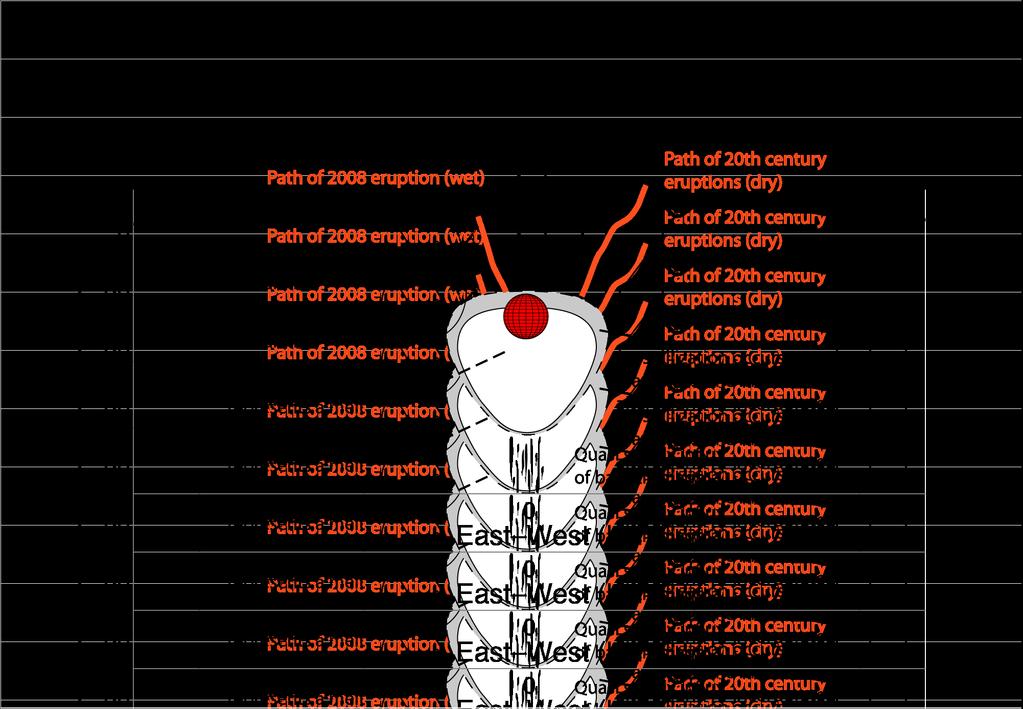
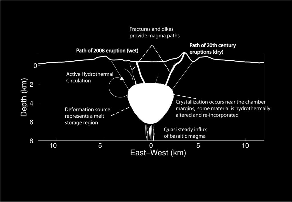
9 Interpretive Cross-Section
10 Re-inflation afterward (4 mo) ' 39' ' ' ' ' ' ' ' ' 3 36' 33' ' 3 5 cm 3 30' 3 OK37 OK31 OK13 27' 2 OKCE OKFG 24' 2 OKSO 21' 18' 15' 12' ' ' ' ' ' ' ' ' ' '

11 Examples from Hawaii Mike Poland, USGS
12 Mike Poland, USGS
13 Continuous Pros > Excellent temporal resolution > After installation, no personnel required (except for maintenance) > Expensive Cons > Low spatial resolution Campaign > High spatial resolution > Inexpensive (equipment is not dedicated to a specific site) > Low temporal resolution > Relatively time-intensive for few data points Kinematic > Can cover a lot of ground in a day > Inexpensive > Excellent spatial resolution in small networks > Low temporal resolution > Requires continuous GPS site as a local reference > Centimeter accuracy (as opposed to millimeter) Mike Poland, USGS
 Magnitude of measureable ground")
 Assuming ~1 mm/km for a 10 km line.")

14 10 cm Magnitude of Measureable Ground Deformation vs. Repeat Time Typical values (may be higher or lower in practice) Magnitude of measureable ground deformation 1 cm Notes (1) Not measuring displacement (2) Vertical only (3) For horizontal displacements (4) Assuming ~1 mm/km for a 10 km line. Uncertainty is for change in line length; uncertainty in horizontal displacements will depend on network geometry, etc. Crack Measurements Continuous GPS (3) InSAR EDM (4) Campaign GPS (3) 1 mm 1 sec Borehole Tilt (1) Leveling (2) 1 hour 1 day 1 week 1 month 1 year 10 years Repeat time Mike Poland, USGS

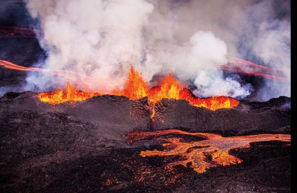
15 ' ' ' ' range change (cm) ' Kīlauea caldera Pu u Ō ō ' Kamoamoa fissure 5 cm 10 km Mike Poland, USGS
 3 0 5 0 2 4 6 8 10 12 14 easting (km) Combining different types of geodetic")
16 0 z (km) disp. magnitude (m) easting (km) Combining different types of geodetic data allows you to image magma sources and transport Lundgren et al., 2013

17 Kinematic GPS

18 The Pu u Ō ō kinematic GPS network Mike Poland, USGS

19 Mike Poland, USGS
20

21 Deformation Through Time Sigmundsson et al. (2015)

22 Sigmundsson et al. (2015)
 2000")

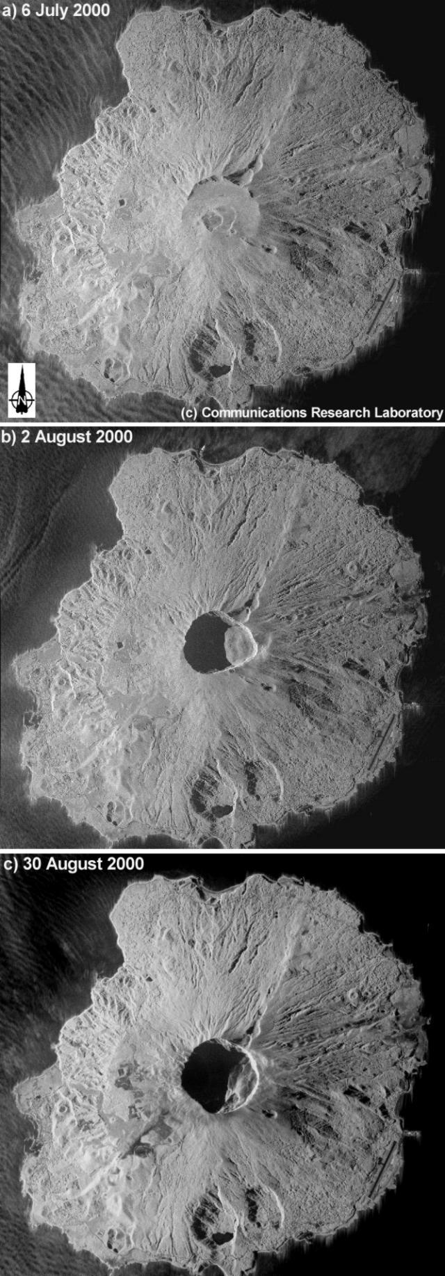
23 Miyakejima (Japan) 2000 Results from GSI, Japan and several papers


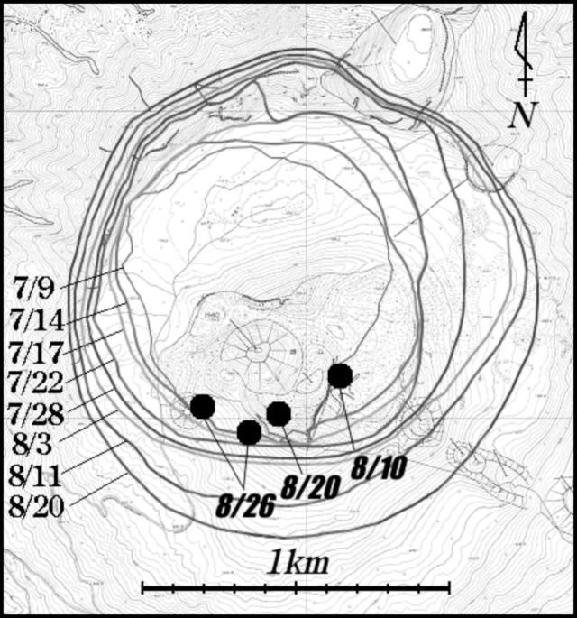
24 GPS Vectors and Time Series Nishimura et al. (2001, GRL)

25 Deformation Model Eruption at Miyakejima was accompanied by Submarine eruption Intrusion of a large dike ~40 km long with meters of opening Collapse of summit after magma drained out Intense seismicity swarm Magma in dike was >> magma removed from Miyakejima

26 Collapse of Summit Caldera

27 Time History of Seismicity

28 Geodetic Model for Dike


29 Stress Change to EQ Rate
30 Montserrat

31 Vulcanian Explosions, Oct No Surface Flux Explosions -> Renewed Dome Growth <-Dome Growth ~13 km <- Subsidence Subsidence Again! -> Inflation -> Photo credits: G. Mattioli Data from: Mattioli et al., 2001; Sparks et al., 1998
32 CALIPSO Borehole Observatory Sacks-Evertson single component dilatometer (10-9 strain) Nearly broadband 3 component seismometer (~2 Hz to 1 khz) Pinnacle Systems short-baseline electronic tiltmeter Ashtech µ-z code-phase CGPS w/ choke ring antenna

33 CALIPSO BH sites and existing CGPS/Telemetry infrastructure
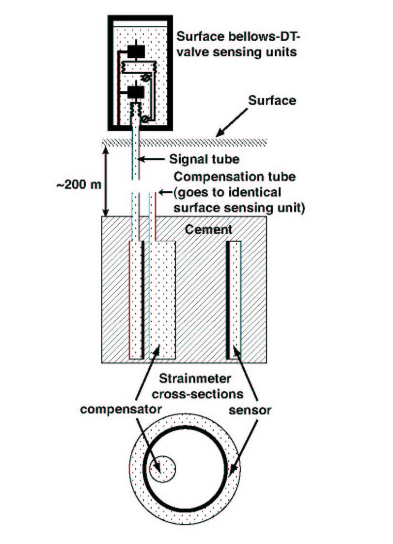
34 Sacks-Evertson single-component dilatometer schematic
35 A. Linde s models of single-component dilatometer data from Iceland NB that strain signal preceded Surface eruption by several hours!

36 Photo of dome in Dec. 02 on a rare clear day. By July 2003 the dome had grown to >230 M m 3 and had not collapsed significantly for 2 years!! Photo credit: G. Mattioli

37 July 12th, Dome collapse begins at 9 AM AST By sunset, pyroclastic flows are getting more energetic and now routinely reach the sea at the Tar River delta. NB white is steam while gray is co-ignimbrite ash cloud. Photo credit: G. Mattioli
 Although Trants site was impacted by ash during the culminating event of the July12th dome collapse, the CALIPSO BH instruments functioned throughout the eruption. Photo credit: G.")
38 Trants Borehole Seismic and Strain Records for July 12th Dome Collapse and Vulcanian event at ~11 PM AST Seismometer 200 Hz (8:03 PM to 12:13AM AST) Strainmeter 50 Hz (8:42 PM to 12:42AM AST) Although Trants site was impacted by ash during the culminating event of the July12th dome collapse, the CALIPSO BH instruments functioned throughout the eruption. Photo credit: G. Mattioli


39 First visit to Air Studios on July 14th cm of ash and 6 cm mud in crypt; NB infrasound microphone under ash, but CALIPSO was still up! Photo credits: G. Mattioli

40 CALIPSO Air Studios site after cleanup on July 14th Photo credit: G. Mattioli
41 Long Valley Interferogram , from Fialko et al. (2001b)
42 An Alternative Source Model Penny-Shaped Crack Use condition of uniform pressure, not uniform displacement
43 Comparison of crack to Mogi Equations are rather complicated If radius is small compared to depth, then Compared to Mogi source that produces same vertical, produces less horizontal (panel b). Cylindrical pipes produce more horizontal than vertical relative to Mogi source Fialko et al. (2001)

44 Long Valley Interferogram , from Fialko et al. (2001b)

45 Sill vs. Prolate Spheroid Both can fit InSAR data
46 Horizontal 2-color laser data InSAR data fit equally well by sill or prolate spheroid Because you can get almost the same vertical profile from different source models Horizontal data fit by spheroid, not sill 7 km depth 2.3:1 vertical:horizontal Nearly vertical long axis (97 )
")
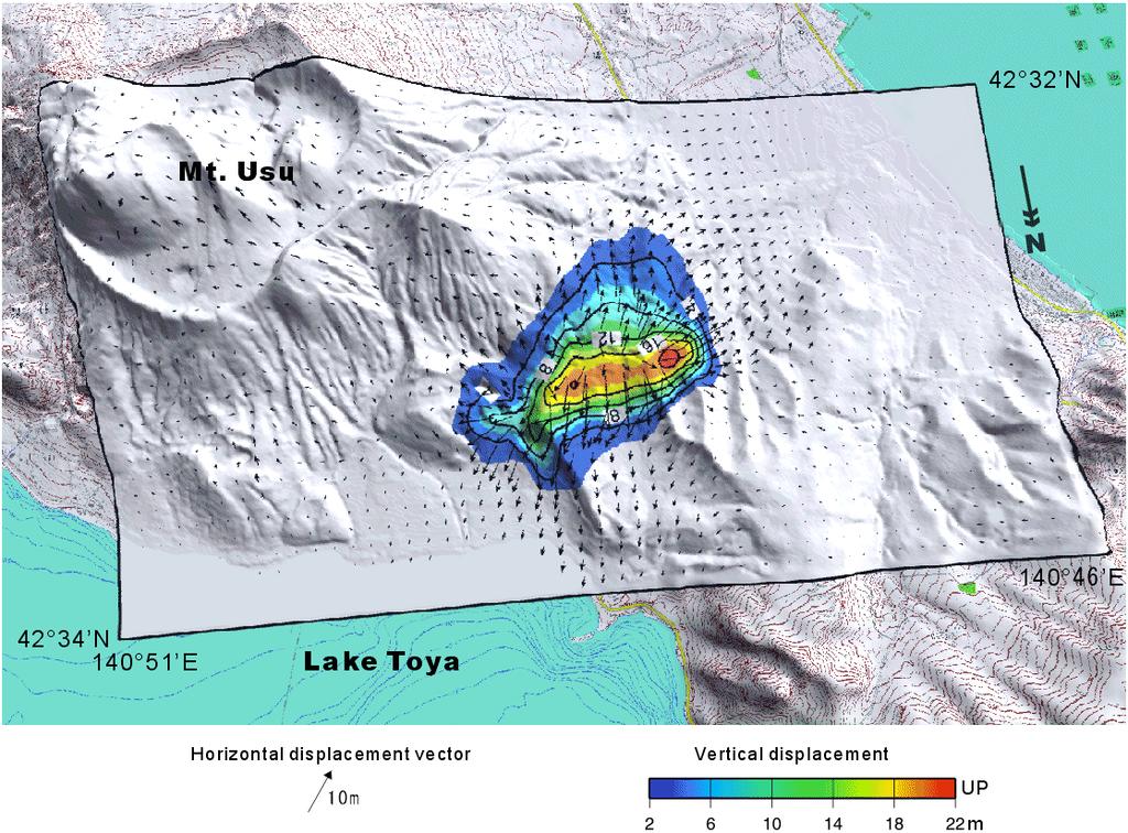
47 Usu (Japan) 2000
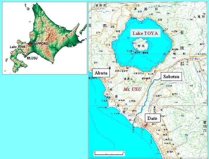
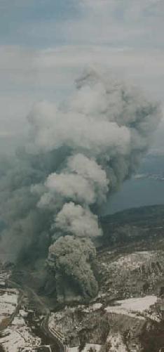
48 No Stratocone
49 Key observations Adjacent to Lake Toya caldera Usu vent not associated with topography New eruptive vent Enormous ground deformation (meters) Data from GPS and from InSAR Complex source to explain Broad area deflation Inflation near vent


50 Sources of Data GPS Baselines InSAR and SAR image correlation

51 GPS Time series

52 Standard InSAR Result

53 Image Correlation (two tracks)
54 Horizontal (2D motions)
55
Supporting the response to the 2018 lower East Rift Zone and summit collapse at Kīlauea Volcano, Hawaiʻi
 Hawaiʻi Supersite success story Supporting the response to the 2018 lower East Rift Zone and summit collapse at Kīlauea Volcano, Hawaiʻi Since 1983, Kīlauea Volcano, on the Island of Hawaiʻi, has actively
EAS 116 Earthquakes and Volcanoes
 EAS 116 Earthquakes and Volcanoes J. Haase Forecasting Volcanic Eruptions Assessment of Volcanic Hazard Is that volcano active? Mount Lassen: 12000 BP and 1915 Santorini, IT: 180,000 BP, 70,000 BP, 21000
What is the Relationship between Pressure & Volume Change in a Magma Chamber and Surface Deformation at Active Volcanoes?
 SSAC-pv2007.QE522.PL1.1 What is the Relationship between Pressure & Volume Change in a Magma Chamber and Surface Deformation at Active Volcanoes? What factors control the magnitude of surface deformation?
Photo credit: S Dumont
 Satellite Monitoring of the 2014 Dyke Intrusion and Eruption within the Bárðarbunga Volcanic System, facilitated by the CEOS Icelandic SUPERSITE M Parks, S Dumont, V Drouin, F Sigmundsson, K Spaans, A
Monthly Volcanic Activity Report (March 2013)
") Monthly Volcanic Activity Report (March 2013) Hakoneyama (Alert Level: 1) Shallow earthquake activity from the area near Mt. Komagatake to Sengokuhara has largely remained at low levels since the middle
Monthly Volcanic Activity Report (March 2013) Hakoneyama (Alert Level: 1) Shallow earthquake activity from the area near Mt. Komagatake to Sengokuhara has largely remained at low levels since the middle
Volcano Seismicity and Tremor. Geodetic + Seismic
 Volcano Seismicity and Tremor Seismic Imaging Geodetic + Seismic Model based joint inversion Geodetic Monitoring How is magma stored in the crust? geometry, volume and physical state of crustal melts.
Monthly Volcanic Activity Report (April 2013)
") Monthly Volcanic Activity Report (April 2013) Zaozan (Calm) Small-amplitude volcanic tremors were recorded on April 7 (duration: 3 min 20 sec), 9 (4 min 20 sec) and 21 (5 min 40 sec). These were the first
Monthly Volcanic Activity Report (April 2013) Zaozan (Calm) Small-amplitude volcanic tremors were recorded on April 7 (duration: 3 min 20 sec), 9 (4 min 20 sec) and 21 (5 min 40 sec). These were the first
GEOS 606 Physical Volcanology GEOS 606 CRN credits
 GEOS 606 Physical Volcanology GEOS 606 CRN 74060 3 credits September 1th December 17 th, 2011 Mondays, Wednesdays and Fridays MWF 10:30-11:30 Irving 208 and Elvey 101 Dr. Jonathan Dehn office: WRRB 108G,
Diverse deformation patterns of Aleutian volcanoes from InSAR
 Diverse deformation patterns of Aleutian volcanoes from InSAR Zhong Lu 1, Dan Dzurisin 1, Chuck Wicks 2, and John Power 3 U.S. Geological Survey 1 Cascades Volcano Observatory, Vancouver, Washington 2
Monthly Volcanic Activity Report (July, 2012)
") Monthly Volcanic Activity Report (July, 2012) Tokachidake [Alert Level: 1] Volcanic glows have been observed in the Taisho crater with a high-sensitivity camera at night from the night of June 30th to
Monthly Volcanic Activity Report (July, 2012) Tokachidake [Alert Level: 1] Volcanic glows have been observed in the Taisho crater with a high-sensitivity camera at night from the night of June 30th to
Monthly Volcanic Activity Report (February, 2011)
") Monthly Volcanic Activity Report (February, 2011) Japan Meteorological Agency Izu-Oshima[ Alert Level : 1] Earthquakes at the western offshore areas of Izu-Oshima increased on 9 th temporarily in this
Monthly Volcanic Activity Report (February, 2011) Japan Meteorological Agency Izu-Oshima[ Alert Level : 1] Earthquakes at the western offshore areas of Izu-Oshima increased on 9 th temporarily in this
Monthly Volcanic Activity Report (March, 2011)
") Monthly Volcanic Activity Report (March, 2011) Japan Meteorological Agency Yakedake[ Alert Level : 1] Just after "The 2011 off the Pacific coast of Tohoku Earthquake" on 11th March, seismicity became higher
Monthly Volcanic Activity Report (March, 2011) Japan Meteorological Agency Yakedake[ Alert Level : 1] Just after "The 2011 off the Pacific coast of Tohoku Earthquake" on 11th March, seismicity became higher
Advanced Workshop on Evaluating, Monitoring and Communicating Volcanic and Seismic Hazards in East Africa.
 2053-11 Advanced Workshop on Evaluating, Monitoring and Communicating Volcanic and Seismic Hazards in East Africa 17-28 August 2009 Seismic monitoring on volcanoes in a multi-disciplinary context Jürgen
to: Interseismic strain accumulation and the earthquake potential on the southern San
 Supplementary material to: Interseismic strain accumulation and the earthquake potential on the southern San Andreas fault system by Yuri Fialko Methods The San Bernardino-Coachella Valley segment of the
Activity Flour box volcano deformation model
 Activity Flour box volcano deformation model A balloon and a box of flour model a magma chamber and overlying rock Some volcanic craters form by the violent expulsion of magma (liquid rock) when it reaches
GSNL - Geohazard Supersites and Natural Laboratories. Biennial report for Candidate/Permanent Supersite. Hawaiʻi Supersite. Annex to report
 Introduction Biennial report for Candidate/Permanent Supersite Hawaiʻi Supersite Annex to 2014 2016 report During 2014 2016, the Hawaiʻi Supersite achieved a number of noteworthy results. This annex details
Monitoring Volcanoes & Predicting Eruptions. I.G Kenyon
 Monitoring Volcanoes & Predicting Eruptions I.G Kenyon Why Monitor? At least 200,000 people killed by volcanoes over the last 500 years Why Monitor? 500 active volcanoes on land 10% of world population
Yellowstone Hotspot Component of the Plate Boundary Observatory
 Yellowstone Hotspot Component of the Plate Boundary Observatory (Investigators: Smith, Thatcher, Meertens, Humphreys, Dzurisin, Oldow Co-Investigators: Christiansen, Doss, Schwartz, Machette, Wong, Olig,
MIGRATING SWARMS OF BRITTLE-FAILURE EARTHQUAKES IN THE LOWER CRUST BENEATH MAMMOTH MOUNTAIN, CALIFORNIA
 MIGRATING SWARMS OF BRITTLE-FAILURE EARTHQUAKES IN THE LOWER CRUST BENEATH MAMMOTH MOUNTAIN, CALIFORNIA David Shelly and David Hill GRL, October 2011 Contents Tectonic Setting Long Valley Caldera Mammoth
A - Piton de la Fournaise activity
 OVPF-IPGP September 2018 Page 1/10 Monthly bulletin of the Piton de la Fournaise Volcanological Observatory ISSN ISSN 2610-5101 A - Piton de la Fournaise activity PITON DE LA FOURNAISE (VNUM #233020) Latitude:
Applied Terrestrial Laser Scanner in active volcano crater: correction to velocity and geometry
 Applied Terrestrial Laser Scanner in active volcano crater: correction to velocity and geometry Nia HAERANI, Hasanuddin Z. ABIDIN, SURONO, Dudy D. WIJAYA, Indonesia FIG Working Week 2015 From the Wisdom
Hands-on Activity Predicting Eruptions on Montserrat
 Hands-on Activity Predicting Eruptions on Montserrat Predicting Eruptions No one can predict exactly when a volcano might explode. There are, however, common clues to look for to let people know that the
3D temporal evolution of displacements recorded on Mt. Etna from the 2007 to 2010 through the SISTEM method
 3D temporal evolution of displacements recorded on Mt. Etna from the 2007 to 2010 through the SISTEM method Bonforte A., Guglielmino F.,, Puglisi G. INGV Istituto Nazionale di Gofisica e vulcanologia Osservatorio
Geophysical Classification of Strombolian Explosive eruption
 Geophysical Classification of Strombolian Explosive eruption Ripepe M. and E. Marchetti Department of Earth Sciences, University of Firenze, Firenze - Italy Monitoring Centre for Civil Protection - Italian
Introduction to Volcanic Seismology
 Introduction to Volcanic Seismology Second edition Vyacheslav M. Zobin Observatorio Vulcanolo'gico, Universidad de Colima, Colima, Col., Mexico ELSEVIER AMSTERDAM BOSTON HEIDELBERG LONDON * NEW YORK OXFORD
Estimating plumes from seismic data: What we can and cannot do
 Estimating plumes from seismic data: What we can and cannot do Matt Haney 1, Stephanie Prejean 1,2, and David Fee 3 1 AVO-USGS, 2 VDAP, 3 AVO-UAFGI Seismic monitoring in Alaska Outline Review of plume
FOUNDATIONS OF GEOLOGY CHAPTER 2
 FOUNDATIONS OF GEOLOGY CHAPTER 2 2.3A- VOLCANOES Volcanoes all share common characteristics. Vent- a central channel through which gases, ash and rock are ejected. Magma- molten rock which lies several
REFERENCE: The Blue Planet An Introduction to Earth System Science. Brian J. Skinner and Barbara W. Murck (2011) Third Edition. John Wiley and Sons
 Third Edition. John Wiley and Sons") REFERENCE: The Blue Planet An Introduction to Earth System Science. Brian J. Skinner and Barbara W. Murck (2011) Third Edition. John Wiley and Sons Inc. PLATE BOUNDARIES OCEAN FLOOR SEISMIC ACTIVITY WORLD'S
REFERENCE: The Blue Planet An Introduction to Earth System Science. Brian J. Skinner and Barbara W. Murck (2011) Third Edition. John Wiley and Sons Inc. PLATE BOUNDARIES OCEAN FLOOR SEISMIC ACTIVITY WORLD'S
A - Piton de la Fournaise activity
 OVPF-IPGP August 2018 Page 1/7 Monthly bulletin of the Piton de la Fournaise Volcanological Observatory ISSN ISSN 2610-5101 A - Piton de la Fournaise activity PITON DE LA FOURNAISE (VNUM #233020) Latitude:
The Santorini Inflation Episode, Monitored by InSAR and GPS
 The Santorini Inflation Episode, Monitored by InSAR and GPS Ioannis Papoutsis 1,2, Xanthos Papanikolaou 2, Michael Floyd 3, Kang Hyeun Ji 4, Charalampos Kontoes 1, Demitris Paradissis 2, Demitris Anastasiou
! Profile of Mauna Loa in Hawaii. Mauna Loa is one of five huge shield volcanoes that make up the island of Hawaii.
 - Shield Volcanoes - Low, rounded profiles; slope angles 2-10 ; composed of numerous flows of mafic composition and little explosive activity - Largest of all volcanoes! Shield volcanoes consist of numerous
FINAL EXAM December 20 th, here at 1:00 3:00 pm
 FINAL EXAM December 20 th, here at 1:00 3:00 pm REVIEW SESSION December 11 th at 6:00-7:30 pm Morrill I Auditorium (Room N375) Same as last time Don t forget your online course evaluations! Major Volcanic
Effects of Eruptions. Most active in the world Kilauea, Hawaii.
 Inside of Old Smokey, All covered with snow, Lurk tons of hot magma, Getting ready to blow, Objectives: From deep in the chamber, Describe how volcanoes can affect people. Up a vent to the top, Describe
Introduction to Earth s s Spheres The Benchmark
 Introduction to Earth s s Spheres The Benchmark Volcanism Volcanic eruptions Effusive: lavas (e.g., Kilauea) Volcanism Volcanic eruptions Explosive: pyroclastic rocks (e.g., Krakatau) Factors Governing
From Punchbowl to Panum: Long Valley Volcanism and the Mono-Inyo Crater Chain
 From Punchbowl to Panum: Leslie Schaffer E105 2002 Final Paper Long Valley Volcanism and the Mono-Inyo Crater Chain Figure 1. After a sequence of earthquakes during the late 1970 s to the early 1980 s
V. Pinel, A. Hooper, S. de la Cruz-Reyna, G. Reyes-Davila, M.P. Doin
 !"#$%&'(&")*&$*('+,-".'/&(.*0$&'(&"1'&-2".3*&4*5.2-/& 6"+-"'3'02-/'*6 78'9'2-"*9*"0 -/$&&:'0.,- ;'02-/'
Falk Amelung. Sang-Ho Yun. Thomas Walter. Asta Miklius. now at GFZ Potsdam. Hawaii Volcano Observatory. Stanford University
 Falk Amelung RSMAS - University of Miami Thomas Walter now at GFZ Potsdam Sang-Ho Yun Stanford University Asta Miklius Hawaii Volcano Observatory Pinatubo 1991 Bautista et al., 98 Mount Pinatubo erupted
Overview of Ch. 4. I. The nature of volcanic eruptions 9/19/2011. Volcanoes and Other Igneous Activity Chapter 4 or 5
 Overview of Ch. 4 Volcanoes and Other Igneous Activity Chapter 4 or 5 I. Nature of Volcanic Eruptions II. Materials Extruded from a Volcano III.Types of Volcanoes IV.Volcanic Landforms V. Plutonic (intrusive)
Living in the shadow of Italy's volcanoes
 Living in the shadow of Italy's volcanoes Where is Mount Etna? Mount Etna is located on the east coast of Sicily roughly midway between Messina and Catania (Figure 1). It is the largest and tallest volcano
Volcanic Monitoring in Long Valley, California. creating a ten-mile by twenty-mile caldera in the Eastern Sierra Nevada region of
 Jensen Grimmer G188 6/6/2013 Volcanic Monitoring in Long Valley, California Abstract: Around 760,000 years ago an explosive eruption shook the western United States creating a ten-mile by twenty-mile caldera
Objectives: Describe how volcanoes can affect people. Describe conditions that cause volcanoes. Describe the relationship between volcanoes and Earth
 Objectives: Describe how volcanoes can affect people. Describe conditions that cause volcanoes. Describe the relationship between volcanoes and Earth s moving plates. Inside of Old Smokey, All covered
Prototype PBO Instrumentation of CALIPSO Project Captures World- Record Lava Dome Collapse of July 2003 on Soufrière Hills Volcano, Montserrat
 Prototype PBO Instrumentation of CALIPSO Project Captures World- Record Lava Dome Collapse of July 2003 on Soufrière Hills Volcano, Montserrat This article is an update on the status of an innovative new
The Geohazard Supersites and Natural Laboratories (GSNL).
.") The Geohazard Supersites and Natural Laboratories (GSNL). Falk Amelung, University of Miami Mike Poland, Hawaii Volcano Observatory Scott Baker, U of Miami, Unavco Outline: Overview over GSNL (Phase 2)
The Geohazard Supersites and Natural Laboratories (GSNL). Falk Amelung, University of Miami Mike Poland, Hawaii Volcano Observatory Scott Baker, U of Miami, Unavco Outline: Overview over GSNL (Phase 2)
Daniel Frost & Stefan Lachowycz
 Daniel Frost & Stefan Lachowycz Studying the Colima active volcano, Mexico 2009 Daniel and Stefan studied Earth Science at Oxford University. For their project they went to Mexico to work as field assistants
MAGMATIC, ERUPTIVE AND TECTONIC PROCESSES IN THE ALEUTIAN ARC, ALASKA
 MAGMATIC, ERUPTIVE AND TECTONIC PROCESSES IN THE ALEUTIAN ARC, ALASKA Introduction The Aleutian Arc contains roughly ten percent of the world s active volcanoes. Hardly a year goes by without a major eruption
A bowl shaped depression formed by the collapse of a volcano is called a. Magma that has left the vent of a volcano is known as. Lava.
 Magma that has left the vent of a volcano is known as Lava A bowl shaped depression formed by the collapse of a volcano is called a Caldera This can form in a caldera when magma starts to come back up
Name Date Class. Answer the following questions. Use your textbook and the ideas above. 1. If a volcano collapses, it leaves a huge hole called a(an).
.") Volcanic Landforms (pages 217 223) Landforms From Lava and Ash (pages 218 220) Key Concept: Volcanic eruptions create landforms made of lava, ash, and other materials. These landforms include shield volcanoes,
Volcanic Landforms (pages 217 223) Landforms From Lava and Ash (pages 218 220) Key Concept: Volcanic eruptions create landforms made of lava, ash, and other materials. These landforms include shield volcanoes,
Geophysical Research Letters
 Geophysical Research Letters 16 FEBRUARY 2006 Volume 33 Number 3 American Geophysical Union Sudden pressure increase in magma reservoir triggered by gigantic lava dome collapse on Montserrat History of
Evolution of the 2007 earthquake swarm, Tanzania: Envisat and ALOS interferometry, ground observations and elastic modeling
 Evolution of the 2007 earthquake swarm, Tanzania: Envisat and ALOS interferometry, ground observations and elastic modeling Gidon Baer, Yariv Hamiel, Gadi Shamir, Ran Nof Geological Survey of Israel East
ASAR IMAGES A DIVERSE SET OF DEFORMATION PATTERNS AT KĪLAUEA VOLCANO, HAWAI`I
 ASAR IMAGES A DIVERSE SET OF DEFORMATION PATTERNS AT KĪLAUEA VOLCANO, HAWAI`I Michael P. Poland (1) (1) U.S. Geological Survey, Hawaiian Volcano Observatory, 51 Crater Rim Road, Hawai`i National Park,
Prototype PBO Instrumentation of CALIPSO Project Captures World- Record Lava Dome Collapse of July 2003 on Soufrière Hills Volcano, Montserrat
 Prototype PBO Instrumentation of CALIPSO Project Captures World- Record Lava Dome Collapse of July 2003 on Soufrière Hills Volcano, Montserrat This article is an update on the status of an innovative new
Tectonics of Magma. From partial melting of mantle Occurs at oceanic ridges and mantle plumes More dense: makes oceanic crust
 VOLCANOES Tectonics of Magma Basaltic magma From partial melting of mantle Occurs at oceanic ridges and mantle plumes More dense: makes oceanic crust Granitic magma From melting of crust, with water as
Structural Geology tectonics, volcanology and geothermal activity. Kristján Saemundsson ÍSOR Iceland GeoSurvey
 Structural Geology tectonics, volcanology and geothermal activity Kristján Saemundsson ÍSOR Iceland GeoSurvey Discussion will be limited to rift zone geothermal systems with sidelook on hot spot environment.
MEASUREMENT OF SURFACE DEFORMATION ASSOCIATED WITH HYDROFRACTURE
 Proceedings, 11 th FIG Symposium on Deformation Measurements, Santorini, Greece, 2003. MEASUREMENT OF SURFACE DEFORMATION ASSOCIATED WITH HYDROFRACTURE Bassam Saleh 1, Balqies Sadoun 1 and Pierre Antoine
Bryson Extra Credit Reading
 VOLCANOES New homework due next Tuesday, Nov 23 Extra Credit Chapter 14 The Fire Below due next Tuesday, Nov 23 Bryson Extra Credit Reading A Short History of Nearly Everything Chapter 14: The Fire Below
Volcanic plume height correlated with magma pressure change at Grímsvötn volcano, Iceland
 SUPPLEMENTARY INFORMATION DOI: 10.1038/NGEO2044 Volcanic plume height correlated with magma pressure change at Grímsvötn volcano, Iceland 1 Supplementary Methods 1.1 Mt. Grímsfjall research station 1.2
NSF-MARGINS Expedition to Anatahan Volcano March 2005
 1 NSF-MARGINS Expedition to Anatahan Volcano March 2005 According to the Emergency Management Office (EMO) report distributed in February 2005, the third historical eruption of Anatahan began on January
A - Piton de la Fournaise activity
 OVPF-IPGP November 2018 Page 1/7 Monthly bulletin of the Piton de la Fournaise Volcanological Observatory ISSN ISSN 2610-5101 A - Piton de la Fournaise activity PITON DE LA FOURNAISE (VNUM #233020) Latitude:
( ) USGS (United States Geological Survey) Watch Green. Normal. alert level 1 Normal
 USGS (United States Geological Survey) Watch Green. Normal. alert level 1 Normal") (200610.1) USGS (United States Geological Survey) 1014 alert level 1 Normal Watch Green Normal USGS WARNING WATCH ADVISORY NORMAL SUMMARY OF VOLCANIC-ALERT LEVELS Highly hazardous eruption underway or
(200610.1) USGS (United States Geological Survey) 1014 alert level 1 Normal Watch Green Normal USGS WARNING WATCH ADVISORY NORMAL SUMMARY OF VOLCANIC-ALERT LEVELS Highly hazardous eruption underway or
Operational use of InSAR for volcano observatories : experience from Montserrat
 Operational use of InSAR for volcano observatories : experience from Montserrat G.Wadge 1, B.Scheuchl 1,5, L.Cabey 1,2, M.D.Palmer 3, C. Riley 3, A. Smith 4, N.F.Stevens 1 1. ESSC, University of Reading,
Foundations of Earth Science, 6e Lutgens, Tarbuck, & Tasa
 Foundations of Earth Science, 6e Lutgens, Tarbuck, & Tasa Fires Within: Igneous Activity Foundations, 6e - Chapter 7 Stan Hatfield Southwestern Illinois College The nature of volcanic eruptions Characteristics
3.2 Notes: Volcanoes Form as Molten Rock Erupts
 3.2 Notes: Volcanoes Form as Molten Rock Erupts Think about What happens when a volcano erupts? Volcanoes erupt many types of material Earth s thin outer layer is, but most of Earth is extremely hot rock
Aira/Sakura-jima. Kyushu, Japan N, E; summit elev m. All times are local (= UTC + 9 hours)
") Aira/Sakura-jima Kyushu, Japan 31.593 N, 130.657 E; summit elev. 1117 m All times are local (= UTC + 9 hours) 2012-2013 Ongoing frequent explosions; ashfall on Kagoshima City This report summarizes activity
Aira/Sakura-jima Kyushu, Japan 31.593 N, 130.657 E; summit elev. 1117 m All times are local (= UTC + 9 hours) 2012-2013 Ongoing frequent explosions; ashfall on Kagoshima City This report summarizes activity
Continuously Monitored by JMA. Latitude: 34 23'49" N, Longitude: '13" E, Elevation: 432 m (Miyatsukayama) (Spot elevation measured by JMA)
 (Spot elevation measured by JMA)") 60. Niijima Continuously Monitored by JMA Latitude: 34 23'49" N, Longitude: 139 16'13" E, Elevation: 432 m (Miyatsukayama) (Spot elevation measured by JMA) Overview of Niijima taken from southeast side
60. Niijima Continuously Monitored by JMA Latitude: 34 23'49" N, Longitude: 139 16'13" E, Elevation: 432 m (Miyatsukayama) (Spot elevation measured by JMA) Overview of Niijima taken from southeast side
INTRODUCTION TO VOLCANIC SEISMOLOGY
 INTRODUCTION TO VOLCANIC SEISMOLOGY V.M. Zobin Observatorio Vulcanologico, Colima, Mexico ELSEVIER Amsterdam - Boston - Heidelberg - London - New York - Oxford Paris - San Diego - San Francisco - Singapore
Problems Associated with Activity Assessment, Dissemination of Information, and Disaster Response During the 2000 Eruption of Miyakejima
 Problems Associated with Activity Assessment, Dissemination of Information, and Disaster Response During the 2000 Eruption of Miyakejima Hidefumi WATANABE * 1. Introduction Volcanic hazard mitigation requires
3-Dimension Deformation Mapping from InSAR & Multiaperture. Hyung-Sup Jung The Univ. of Seoul, Korea Zhong Lu U.S. Geological Survey, U.S.A.
 3-Dimension Deformation Mapping from InSAR & Multiaperture InSAR Hyung-Sup Jung The Univ. of Seoul, Korea Zhong Lu U.S. Geological Survey, U.S.A. Outline Introduction to multiple-aperture InSAR (MAI) 3-D
Pavlof. Alaska Peninsula N, W; summit elev. 2,519 m. All times are local (= UTC - 9 hours)
") Pavlof Alaska Peninsula 55.42 N, 161.887 W; summit elev. 2,519 m All times are local (= UTC - 9 hours) Eruption in May-June 2013 with lava flows and ash emissions to ~8.5 km a.s.l. Pavlof, the most active
Pavlof Alaska Peninsula 55.42 N, 161.887 W; summit elev. 2,519 m All times are local (= UTC - 9 hours) Eruption in May-June 2013 with lava flows and ash emissions to ~8.5 km a.s.l. Pavlof, the most active
Monthly Volcanic Activity Report (November 2015)
") Monthly Volcanic Activity Report (November 2015) Japan Meteorological Agency Meakandake (Alert Level: 1) Alert level downgrade from 2 to 1 on 13 November A field survey conducted from 2 to 5 November showed
Monthly Volcanic Activity Report (November 2015) Japan Meteorological Agency Meakandake (Alert Level: 1) Alert level downgrade from 2 to 1 on 13 November A field survey conducted from 2 to 5 November showed
Annual Report:
 Annual Report for Period:04/2002-04/2003 Submitted on: 10/01/2002 Principal Investigator: Jansma, Pamela E. Award ID: 0116485 Organization: U of Arkansas Title: Collaborative research: magma reservoir-conduit
Study guide chapter 9
 Study guide chapter 9 1. What are the three ways solid mantle material can change phase to a liquid? Associate a boundary/hot spot to each way mantle material changes phase. 1. A decrease in pressure which
The Quaternary and Pliocene Yellowstone Plateau Volcanic Field of Wyoming, Idaho and Montana Robert L. Christenson, USGS PP 729-G
 The Quaternary and Pliocene Yellowstone Plateau Volcanic Field of Wyoming, Idaho and Montana Robert L. Christenson, USGS PP 729-G Three Volcanic Cycles of Yellowstone Three extraordinarily large explosive
VOLCANO MONITORING PRACTICAL. Hazard alert levels established for communication at Mt. Pinatubo
 VOLCANO MONITORING PRACTICAL Predicting volcanic eruptions is a hazardous and stressful business. If an eruption has occurred and was not predicted then the volcanologists get the blame for not giving
Chapter 5 9/10/2011. Introduction. Volcanoes and Volcanism. Volcanism. Introduction. Introduction. Introduction
 Introduction Chapter 5 Volcanism is the eruption of magma, and associated gases at the surface. Some magma erupts explosively as pyroclastic (fire-broken) rock and other erupts as lava flows. Volcanoes
PUBLICATIONS. Geochemistry, Geophysics, Geosystems
 PUBLICATIONS Geochemistry, Geophysics, Geosystems RESEARCH ARTICLE Key Points: Strain data analysis from explosions/ degassing events at Soufriere Hills Volcano Pressure release deep within the magmatic
Engineering Geology ECIV 2204
 Engineering Geology ECIV 2204 2017-2016 Chapter (4) Volcanoes Chapter 4: Volcanoes and Other Igneous Activity cataclysmic relating to or denoting a violent natural even Eventually the entire
VOLCANOES. Homework due Wed./Thurs. I have a few copies left, or get by moodle or webpage
 VOLCANOES Homework due Wed./Thurs. I have a few copies left, or get by moodle or webpage Bowen s Reaction Series Oceanic basin tectonics http://my.execpc.com/~acmelasr/mountains/geogramsnf.html Icelandic
Volcanoes. Table of Contents Volcanoes and Plate Tectonics Volcanic Eruptions Volcanic Landforms
 Volcanoes Table of Contents Volcanoes and Plate Tectonics Volcanic Eruptions Volcanic Landforms What is a volcano? cone Conduit Or Pipe vent Side vent Central vent Crater A volcano is a vent or 'chimney'
Study Guide: Unit 1. 1) Take careful notes in class during the lectures as well as the information given in the slides presented during class
 Take careful notes in class during the lectures as well as the information given in the slides presented during class") Geology 101 Study Guide: Unit 1 The purpose of this study guide is to help you prepare for the first unit exam by focusing your studying and providing example essay questions. You will not be asked to
Geology 101 Study Guide: Unit 1 The purpose of this study guide is to help you prepare for the first unit exam by focusing your studying and providing example essay questions. You will not be asked to
Case History: Mt. St. Helens
 Case History: Mt. St. Helens EAS 458 Volcanology Introduction 1980 eruption of Mt. St. Helens was particularly interesting and violent eruption with an unusual lateral blast. In the 1970 s, the USGS (Crandell(
Monthly Volcanic Activity Report (April 2015)
") Monthly Volcanic Activity Report (April 2015) Japan Meteorological Agency Meakandake (Alert Level: 1) The number of small shallow earthquakes occurring near the Ponmachineshiri crater increased from 15
Monthly Volcanic Activity Report (April 2015) Japan Meteorological Agency Meakandake (Alert Level: 1) The number of small shallow earthquakes occurring near the Ponmachineshiri crater increased from 15
GEOL1 Physical Geology Laboratory Manual College of the Redwoods Lesson Five: Volcanoes Background Reading: Volcanoes Volcanic Terms: Silca:
 Name: Date: GEOL1 Physical Geology Laboratory Manual College of the Redwoods Lesson Five: Volcanoes Background Reading: Volcanoes Volcanic Terms: Silca: SiO 2 silicon dioxide. This is quartz when it crystallizes.
Journal of Volcanology and Geothermal Research
 Journal of Volcanology and Geothermal Research 278 279 (24) 59 85 Contents lists available at ScienceDirect Journal of Volcanology and Geothermal Research journal homepage: www.elsevier.com/locate/jvolgeores
Spatiotemporal gravity changes at Miyakejima Volcano, Japan: Caldera collapse, explosive eruptions and magma movement
 JOURNAL OF GEOPHYSICAL RESEARCH, VOL. 108, NO. B4, 2219, doi:10.1029/2002jb001989, 2003 Spatiotemporal gravity changes at Miyakejima Volcano, Japan: Caldera collapse, explosive eruptions and magma movement
Journal Publications (current reporting period , not reported below)
") Journal Publications (2005 to 2011) A number of papers have been published related to CALIPSO, SEA-CALIPSO, and the CALIPSO Facility, including many recently. Seven papers were presented at the Soufriere
Journal Publications (2005 to 2011) A number of papers have been published related to CALIPSO, SEA-CALIPSO, and the CALIPSO Facility, including many recently. Seven papers were presented at the Soufriere
MVO Activity Reports 2009
 MVO Activity Reports 2009 Ash from the 3 January 2009 explosions Open File Report OFR 13-04 8 March 2013 Montserrat Volcano Observatory - P.O. Box 318 - Flemmings Montserrat Tel : +1 (664) 491-5647 Fax:
Determining the relationship between the summit and Pu u Ō ō on Kilauea
 Name: Determining the relationship between the summit and Pu u Ō ō on Kilauea After completing this activity, you will be able to: 1. summarize the physical events that produce the data volcanologists
Effect of mechanical heterogeneity in arc crust on volcano deformation with application to Soufrière Hills Volcano, Montserrat, West Indies
 JOURNAL OF GEOPHYSICAL RESEARCH, VOL. 115,, doi:10.1029/2009jb006909, 2010 Effect of mechanical heterogeneity in arc crust on volcano deformation with application to Soufrière Hills Volcano, Montserrat,
Detecting the Source Location of Recent Summit Inflation via Three-Dimensional InSAR Observation of Kīlauea Volcano
 Remote Sens. 2015, 7, 14386-14402; doi:10.3390/rs71114386 Article OPEN ACCESS remote sensing ISSN 2072-4292 www.mdpi.com/journal/remotesensing Detecting the Source Location of Recent Summit Inflation via
Case Study of Japan: Crustal deformation monitoring with GNSS and InSAR
 Technical Seminar Reference Frame in Practice, Case Study of Japan: Crustal deformation monitoring with GNSS and InSAR Basara Miyahara miyahara-b96ip@milt.go.jp Geospatial Information Authority of Japan
Continuously Monitored by JMA. Latitude: 34 13'10" N, Longitude: '11" E, Elevation: 572 m (Tenjosan) (Triangulation Point - Kozushima)
 (Triangulation Point - Kozushima)") 61. Kozushima Continuously Monitored by JMA Latitude: 34 13'10" N, Longitude: 139 09'11" E, Elevation: 572 m (Tenjosan) (Triangulation Point - Kozushima) Overview of Kozushima taken from south-southeast
61. Kozushima Continuously Monitored by JMA Latitude: 34 13'10" N, Longitude: 139 09'11" E, Elevation: 572 m (Tenjosan) (Triangulation Point - Kozushima) Overview of Kozushima taken from south-southeast
About Volcanoes Volcanology IMPORTANT TERMS
 About Volcanoes IMPORTANT TERMS magma Rock that is molten (in liquid form due to heating). When magma reaches the surface, it is called lava. lava magma reservoir An underground pool that is filled with
Characteristics of Volcanic Activity at Sakurajima Volcanoʼs Showa Crater During the Period 2006 to 2011
 Article Bull. Volcanol. Soc. Japan Vol. 58 (2013) No. 1, pp. 115-135 Characteristics of Volcanic Activity at Sakurajima Volcanoʼs Showa Crater During the Period 2006 to 2011 Masato IGUCHI, Takeshi TAMEGURI
Volcano: a weak spot in the crust where molten material or magma comes to the surface
 Chapter 7 Volcano: a weak spot in the crust where molten material or magma comes to the surface Magma: a molten mixture of rock forming substances, gases and H 2 O from the mantle Volcanic Belts: Form
Global Positioning System(GPS) Global Positioning System(GPS) is a new surveying technique applying space technology designed by the United States
 Global Positioning System(GPS) is a new surveying technique applying space technology designed by the United States") IV/317 Crustal deformations in the Japanese islands observed with the nationwide continuous GPS observation system Takashi TADA (Crustal Dynamics Department, Geographical Survey Institute, Tsukuba, Ibaraki,
IV/317 Crustal deformations in the Japanese islands observed with the nationwide continuous GPS observation system Takashi TADA (Crustal Dynamics Department, Geographical Survey Institute, Tsukuba, Ibaraki,
USGS Volcano Hazards Program
 USGS Volcano Hazards Program NAS Board on Earth Sciences and Resources May 12, 2014 Charlie Mandeville USGS Program Coordinator cmandeville@usgs.gov www.volcanoes.usgs.gov Volcano Hazards Program Mission:
Deep magma storage at Hekla volcano, Iceland, revealed by InSAR time series analysis
 JOURNAL OF GEOPHYSICAL RESEARCH, VOL. 116,, doi:10.1029/2010jb007576, 2011 Deep magma storage at Hekla volcano, Iceland, revealed by InSAR time series analysis Benedikt G. Ofeigsson, 1 Andrew Hooper, 2
Magma flux at Okmok Volcano, Alaska, from a joint inversion of continuous GPS, campaign GPS, and interferometric synthetic aperture radar
 JOURNAL OF GEOPHYSICAL RESEARCH, VOL. 115,, doi:10.1029/2010jb007577, 2010 Magma flux at Okmok Volcano, Alaska, from a joint inversion of continuous GPS, campaign GPS, and interferometric synthetic aperture
GEODETIC EVIDENCE FOR SLOW INFLATION OF THE SANTORINI CALDERA
 Proceedings, 11 th FIG Symposium on Deformation Measurements, Santorini, Greece, 2003. GEODETIC EVIDENCE FOR SLOW INFLATION OF THE SANTORINI CALDERA Stathis Stiros 1, Aris Chasapis 2 and Villy Kontogianni
Why was this eruption important?
 Mount St. Helens Mount St. Helens has a long geological history (>3,000 yrs) of explosive eruptions. The 1980 Events: Initial relatively mild steam and ash (Vulcanian) eruptions. Sustained plinian eruption